Bridge Statistics for Woodbridge, New Jersey (NJ)
Condition, Traffic, Stress, Structural Evaluation, Project Costs
- National Bridge Inventory (NBI) Statistics
- 53Number of bridges
- 531ft / 162mTotal length
- $5,305,000Total costs
- 2,355,062Total average daily traffic
- 187,718Total average daily truck traffic
- National Bridge Inventory (NBI) Registered Bridges for Woodbridge
- No street view available for this location
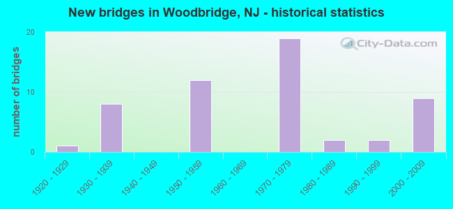
- New bridges - historical statistics
- 11920-1929
- 81930-1939
- 121950-1959
- 191970-1979
- 21980-1989
- 21990-1999
- 92000-2009
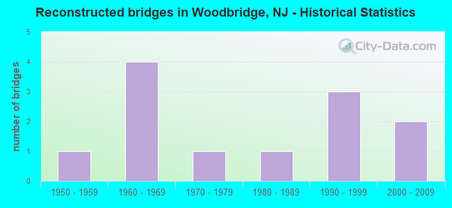
- Reconstructed bridges - Historical Statistics
- 11950-1959
- 41960-1969
- 11970-1979
- 11980-1989
- 31990-1999
- 22000-2009
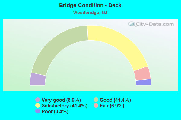
- Bridge Condition - Deck
- 6.9%Very good
- 41.4%Good
- 41.4%Satisfactory
- 6.9%Fair
- 3.4%Poor
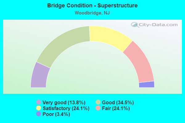
- Bridge Condition - Superstructure
- 13.8%Very good
- 34.5%Good
- 24.1%Satisfactory
- 24.1%Fair
- 3.4%Poor
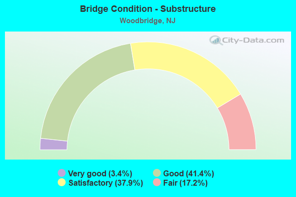
- Bridge Condition - Substructure
- 3.4%Very good
- 41.4%Good
- 37.9%Satisfactory
- 17.2%Fair
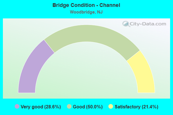
- Bridge Condition - Channel
- 28.6%Very good
- 50.0%Good
- 21.4%Satisfactory
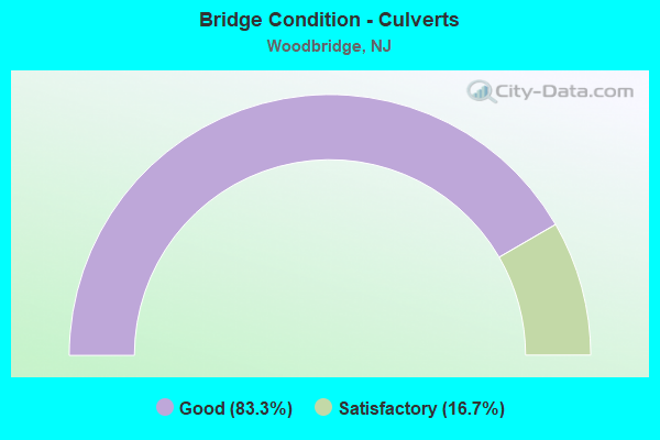
- Bridge Condition - Culverts
- 83.3%Good
- 16.7%Satisfactory
Find on map >> Show street view
Structure Number: 361287N, Location: .75 MI N OF GSP&RT440 JCT (Lat: 40.529967, Lng: -74.298064), Route carried "under" structure: US 9, Year Built: 1953, Structure Length: 0. m, Average Daily Traffic: 45,512 (year 2021), Truck Traffic: 4%, Features Intersected: US ROUTE 9 (SB), Facility Carried by Structure: GSP (NORTH BOUND)
Minimum Vertical Clearance: 5.05m (16.57ft), Kilometerpoint: 215.169, Lanes on structure: 5, Lanes under structure: 3, Material/Design: Steel, Design/Construction: Stringer/Multi-beam, Length of Maximum Span: 51.2m (168.0ft)
Find on map >> Show street view
Structure Number: M09102A, Location: 0.25 MI W OF ROUTE 9 (Lat: 40.543797, Lng: -74.294281), Route carried "under" structure: Ramp Other road 95, Year Built: 1970, Structure Length: 0. m, Average Daily Traffic: 5,200 (year 2021), Truck Traffic: 1%, Features Intersected: NJ TPK INTER.11 RAMP TSO, Facility Carried by Structure: NJTPK NSO ROADWAY
Minimum Vertical Clearance: 4.82m (15.81ft), Kilometerpoint: 73.467, Lanes on structure: 3, Lanes under structure: 1, Toll: On toll road, Material/Design: Steel, Design/Construction: Stringer/Multi-beam, Length of Maximum Span: 27.4m (89.9ft)
Find on map >> Show street view
Structure Number: M09113, Location: .9 MI E RTE 444 & NJ TPK (Lat: 40.543519, Lng: -74.291600), Route carried "under" structure: Interstate 95, Year Built: 1951, Structure Length: 0. m, Average Daily Traffic: 117,000 (year 2021), Features Intersected: NJ TPK NSI-SNI-SNO RWYS, Facility Carried by Structure: US RTE 9
Minimum Vertical Clearance: 8.38m (27.49ft), Kilometerpoint: 73.692, Lanes on structure: 6, Lanes under structure: 9, Toll: On toll road, Material/Design: Steel, Design/Construction: Stringer/Multi-beam, Length of Maximum Span: 25.3m (83.0ft)
Find on map >> Show street view
Structure Number: M09115S, Location: .9 MI E RTE 444 & NJ TPK (Lat: 40.545000, Lng: -74.291667), Route carried "under" structure: US 9, Year Built: 1951, Structure Length: 0. m, Average Daily Traffic: 97,442 (year 2021), Truck Traffic: 4%, Features Intersected: US RTE 9, Facility Carried by Structure: NJ TPK NSO RWY
Minimum Vertical Clearance: 4.65m (15.26ft), Kilometerpoint: 216.972, Lanes on structure: 3, Lanes under structure: 6, Toll: On toll road, Material/Design: Steel, Design/Construction: Stringer/Multi-beam, Length of Maximum Span: 18.9m (62.0ft)
Find on map >> Show street view
Structure Number: M09132A, Location: 1.1 MI E RTE 444 & NJ TPK (Lat: 40.543333, Lng: -74.288333), Route carried "under" structure: Interstate 95, Year Built: 1970, Structure Length: 0. m, Average Daily Traffic: 158,477 (year 2021), Truck Traffic: 17%, Features Intersected: NJ TURNPIKE, Facility Carried by Structure: NJTPK INT.11 R.N0T
Minimum Vertical Clearance: 8.38m (27.49ft), Kilometerpoint: 73.965, Lanes on structure: 2, Lanes under structure: 12, Toll: On toll road, Material/Design: Steel, Design/Construction: Stringer/Multi-beam, Length of Maximum Span: 23.2m (76.1ft)
Find on map >> Show street view
Structure Number: M09136A, Location: 1.15 MI E RT. 444 & NJTPK (Lat: 40.545533, Lng: -74.286153), Route carried "under" structure: Interstate 95, Year Built: 1970, Structure Length: 0. m, Average Daily Traffic: 117,600 (year 2021), Truck Traffic: 9%, Features Intersected: NJTPK NSI-SNI-SNO RWYS, Facility Carried by Structure: NJTPK INT.11 R.NIT
Minimum Vertical Clearance: 9.02m (29.59ft), Kilometerpoint: 73.965, Lanes on structure: 2, Lanes under structure: 9, Toll: On toll road, Material/Design: Steel, Design/Construction: Stringer/Multi-beam, Length of Maximum Span: 23.8m (78.1ft)
Find on map >> Show street view
Structure Number: M09137A, Location: 1.2 MI E RTE 444 & NJ TPK (Lat: 40.545000, Lng: -74.286667), Route carried "under" structure: Interstate 95, Year Built: 1970, Structure Length: 0. m, Average Daily Traffic: 40,576 (year 2021), Truck Traffic: 9%, Features Intersected: NJ TURNPIKE SNO RWY, Facility Carried by Structure: NJTPK INT.11 R.TNI
Minimum Vertical Clearance: 5.05m (16.57ft), Kilometerpoint: 73.965, Lanes on structure: 2, Lanes under structure: 3, Toll: On toll road, Material/Design: Steel, Design/Construction: Stringer/Multi-beam, Length of Maximum Span: 37.2m (122.0ft)
Find on map >> Show street view
Structure Number: M09189, Location: 1.65 MI E RT 444 & NJ TPK (Lat: 40.548333, Lng: -74.280000), Route carried "under" structure: Interstate 95, Year Built: 1950, Structure Length: 0. m, Average Daily Traffic: 191,036 (year 2021), Truck Traffic: 9%, Features Intersected: NJ TURNPIKE, Facility Carried by Structure: NJ 35-AMBOY AVENUE
Minimum Vertical Clearance: 6.74m (22.11ft), Kilometerpoint: 74.883, Lanes on structure: 4, Lanes under structure: 16, Toll: On toll road, Material/Design: Steel, Design/Construction: Stringer/Multi-beam, Length of Maximum Span: 24.1m (79.1ft)
Find on map >> Show street view
Structure Number: M09208W, Location: 1.8 MI E RTE.444 & NJ TPK (Lat: 40.551528, Lng: -74.276639), Route carried "under" structure: City street , Year Built: 1950, Structure Length: 0. m, Average Daily Traffic: 333 (year 2021), Truck Traffic: 1%, Features Intersected: LEGION PLACE, Facility Carried by Structure: FULTON STREET
Minimum Vertical Clearance: 4.67m (15.32ft), Kilometerpoint: 0.000, Lanes on structure: 2, Lanes under structure: 2, Material/Design: Steel, Design/Construction: Stringer/Multi-beam, Length of Maximum Span: 17.1m (56.1ft)
Find on map >> Show street view
Structure Number: M09211A, Location: 1.86 MI E RT.444 & NJ TPK (Lat: 40.550853, Lng: -74.275661), Route carried "under" structure: Interstate 95, Year Built: 1991, Structure Length: 0. m, Average Daily Traffic: 199,550 (year 2021), Truck Traffic: 15%, Features Intersected: NJ TURNPIKE, Facility Carried by Structure: NJ TPK MP 92 U-TRN
Minimum Vertical Clearance: 5.21m (17.09ft), Kilometerpoint: 75.253, Lanes on structure: 2, Lanes under structure: 14, Toll: On toll road, Material/Design: Steel continuous, Design/Construction: Stringer/Multi-beam, Length of Maximum Span: 21.6m (70.9ft)
Find on map >> Show street view
Structure Number: M09251, Location: 0.6 MI NORTH OF NJ 35 (Lat: 40.553333, Lng: -74.270000), Route carried "under" structure: Interstate 95, Year Built: 1970, Structure Length: 0. m, Average Daily Traffic: 196,710 (year 2021), Truck Traffic: 9%, Features Intersected: NJ TPK RWYS & RAMPS, Facility Carried by Structure: WOODBRIDGE AVENUE
Minimum Vertical Clearance: 5.82m (19.09ft), Kilometerpoint: 75.881, Lanes on structure: 2, Lanes under structure: 17, Toll: On toll road, Material/Design: Steel, Design/Construction: Stringer/Multi-beam, Length of Maximum Span: 42.1m (138.1ft)