Bridge Statistics for Worcester, Massachusetts (MA)
Condition, Traffic, Stress, Structural Evaluation, Project Costs
- National Bridge Inventory (NBI) Statistics
- 124Number of bridges
- 2,149ft / 655mTotal length
- $518,007,000Total costs
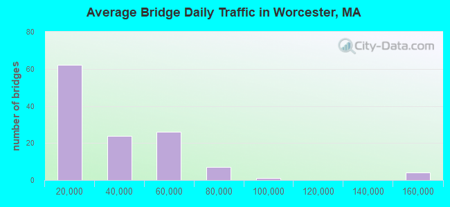
- 3,635,557Total average daily traffic
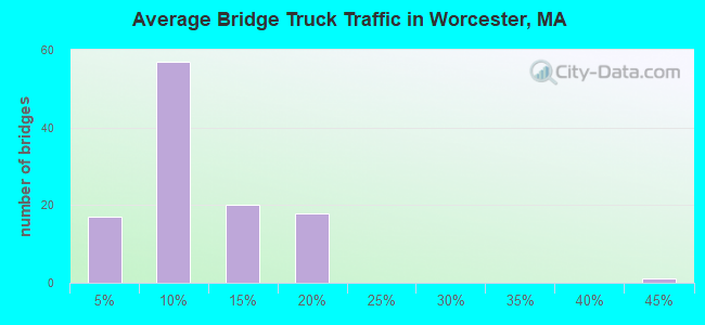
- 291,168Total average daily truck traffic
- National Bridge Inventory (NBI) Registered Bridges for Worcester
- No street view available for this location
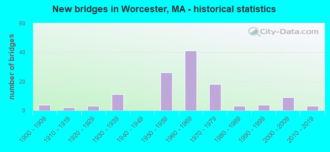
- New bridges - historical statistics
- 41900-1909
- 21910-1919
- 31920-1929
- 111930-1939
- 261950-1959
- 411960-1969
- 181970-1979
- 31980-1989
- 41990-1999
- 92000-2009
- 32010-2019
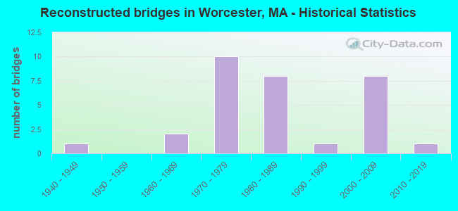
- Reconstructed bridges - Historical Statistics
- 11940-1949
- 01950-1959
- 21960-1969
- 101970-1979
- 81980-1989
- 11990-1999
- 82000-2009
- 12010-2019
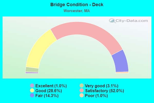
- Bridge Condition - Deck
- 1.0%Excellent
- 3.1%Very good
- 28.6%Good
- 52.0%Satisfactory
- 14.3%Fair
- 1.0%Poor
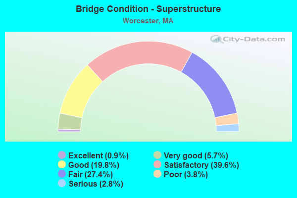
- Bridge Condition - Superstructure
- 0.9%Excellent
- 5.7%Very good
- 19.8%Good
- 39.6%Satisfactory
- 27.4%Fair
- 3.8%Poor
- 2.8%Serious
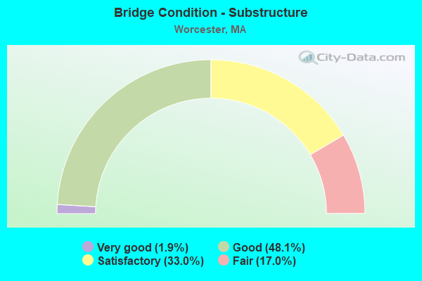
- Bridge Condition - Substructure
- 1.9%Very good
- 48.1%Good
- 33.0%Satisfactory
- 17.0%Fair
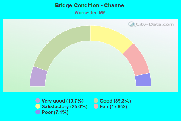
- Bridge Condition - Channel
- 10.7%Very good
- 39.3%Good
- 25.0%Satisfactory
- 17.9%Fair
- 7.1%Poor
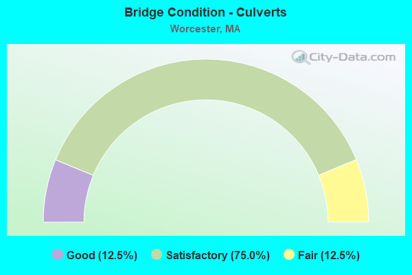
- Bridge Condition - Culverts
- 12.5%Good
- 75.0%Satisfactory
- 12.5%Fair
Find on map >> Show street view
Structure Number: W440011DNMUNNBI, Location: .1 MI. W. OF TATNUCK SQ. (Lat: 42.279692, Lng: -71.855872), Route carried "on" structure: City street , Year Built: 1920, Status: Open, Structure Length: 0.77m (2.53ft), Average Daily Traffic: 4,644 (year 2019), Truck Traffic: 6%, Average Future Daily Traffic: 10,739 (year 2031), Features Intersected: WATER TATNUCK BROOK, Facility Carried by Structure: HWY MOWER ST
Minimum Vertical Clearance: 30+ m (98+ ft), Kilometerpoint: 1.867, Lanes on structure: 2, Owner: City or Municipal Highway Agency, Approaching Roadway Width: 10.7m (35.1ft), Skew: 1 degrees, Material/Design: Concrete, Design/Construction: Arch - Deck, Number Of Spans In Main Unit: 1, Length of Maximum Span: 7.7m (25.3ft), Curb or Sidewalk Widths: Left: 2.7m (8.9ft), Right: 2.9m (9.5ft), Curb-To-Curb Width: 10.6m (34.8ft), Out-to-Out Width: 16.8m (55.1ft)
Condition: Superstructure: Fair, Substructure: Good, Channel: Satisfactory, Operating Rating: 68.3 metric tons, Method Used To Determine Operating Rating: Load Factor (LF), Inventory Rating: 40.9 metric tons, Method Used To Determine Inventory Rating: Load Factor (LF), Structural Evaluation: Somewhat better than minimum adequacy, Deck Geometry: Somewhat better than minimum adequacy, Waterway Adequacy: Better than present minimum criteria, Approach Roadway Alignment: Better than present minimum criteria, Length Of Structure Improvement: 0.80m (2.62ft), Designated Inspection Frequency: Every 24 months, Inspection Date: December 2020, Bridge Improvement Cost: $528,000, Roadway Improvement Cost: $53,000, Total Project Cost: $793,000 ( Estimate for 2022)
Find on map >> Show street view
Structure Number: W440021DPMUNNBI, Location: 500 FT S OF CHANDLER ST (Lat: 42.274758, Lng: -71.854158), Route carried "on" structure: City street , Year Built: 1992, Status: Open, Structure Length: 1.40m (4.59ft), Average Daily Traffic: 10,529 (year 2019), Truck Traffic: 6%, Average Future Daily Traffic: 15,635 (year 2031), Design Load: HS 20, Features Intersected: WATER TATNUCK BROOK, Facility Carried by Structure: HWY MILL ST
Minimum Vertical Clearance: 30+ m (98+ ft), Kilometerpoint: 3.219, Lanes on structure: 2, Owner: City or Municipal Highway Agency, Approaching Roadway Width: 13.4m (44.0ft), Material/Design: Prestressed concrete, Design/Construction: Slab, Number Of Spans In Main Unit: 1, Length of Maximum Span: 13.1m (43.0ft), Curb or Sidewalk Widths: Left: 1.8m (5.9ft), Right: 1.8m (5.9ft), Curb-To-Curb Width: 13.4m (44.0ft), Out-to-Out Width: 17.9m (58.7ft)
Condition: Deck: Fair, Superstructure: Fair, Substructure: Satisfactory, Channel: Good, Operating Rating: 60.4 metric tons, Method Used To Determine Operating Rating: Allowable Stress (AS), Inventory Rating: 36.5 metric tons, Method Used To Determine Inventory Rating: Allowable Stress (AS), Structural Evaluation: Somewhat better than minimum adequacy, Deck Geometry: Equal to present minimum criteria, Waterway Adequacy: Equal to present desirable criteria, Approach Roadway Alignment: Equal to present desirable criteria, Length Of Structure Improvement: 1.50m (4.92ft), Designated Inspection Frequency: Every 24 months, Inspection Date: November 2020, Bridge Improvement Cost: $1,055,000, Roadway Improvement Cost: $106,000, Total Project Cost: $1,583,000 ( Estimate for 2022), Deck Structure Type: Concrete Precast Panels, Wearing Surface/Protective System: Wearing Surface: Bituminous, Membrane: Built-up, Deck Protection: Epoxy Coated Reinforcing
Find on map >> Show street view
Structure Number: W440031DQMUNNBI, Location: .1 MI. E. OF MILL ST (Lat: 42.262217, Lng: -71.848200), Route carried "on" structure: City street , Year Built: 1905, Status: Open, Structure Length: 1.74m (5.71ft), Average Daily Traffic: 4,633 (year 2020), Truck Traffic: 5%, Average Future Daily Traffic: 15,003 (year 2031), Features Intersected: WATER TATNUCK BROOK, Facility Carried by Structure: HWY JUNE ST
Minimum Vertical Clearance: 30+ m (98+ ft), Kilometerpoint: 0.274, Lanes on structure: 2, Owner: City or Municipal Highway Agency, Approaching Roadway Width: 8.2m (26.9ft), Skew: 3 degrees, Material/Design: Masonry, Design/Construction: Arch - Deck, Number Of Spans In Main Unit: 2, Length of Maximum Span: 7.9m (25.9ft), Curb or Sidewalk Widths: Left: 1.6m (5.2ft), Right: 1.8m (5.9ft), Curb-To-Curb Width: 8.4m (27.6ft), Out-to-Out Width: 12.2m (40.0ft)
Condition: Superstructure: Serious, Substructure: Satisfactory, Channel: Satisfactory, Structural Evaluation: High priority of corrective action, Deck Geometry: High priority of corrective action, Waterway Adequacy: Better than present minimum criteria, Approach Roadway Alignment: Equal to present minimum criteria, Length Of Structure Improvement: 1.80m (5.91ft), Designated Inspection Frequency: Every 6 months, Other Special Inspection Frequency: Every 6 months, Inspection Date: June 2020, Other Special Inspection Date: December 2021, Bridge Improvement Cost: $863,000, Roadway Improvement Cost: $87,000, Total Project Cost: $1,295,000 ( Estimate for 2022)
Find on map >> Show street view
Structure Number: W440061JFMUNNBI, Location: .25 MI W OF PARK AVE (Lat: 42.258336, Lng: -71.826944), Route carried "on" structure: City street , Year Built: 1908, Status: Open, Structure Length: 0.91m (2.99ft), Average Daily Traffic: 8,300 (year 2019), Truck Traffic: 5%, Average Future Daily Traffic: 24,637 (year 2031), Features Intersected: WATER BEAVER BRK/SEWER, Facility Carried by Structure: HWY MAY ST
Minimum Vertical Clearance: 30+ m (98+ ft), Kilometerpoint: 3.009, Lanes on structure: 2, Owner: City or Municipal Highway Agency, Approaching Roadway Width: 10.4m (34.1ft), Skew: 3 degrees, Material/Design: Concrete, Design/Construction: Arch - Deck, Number Of Spans In Main Unit: 1, Length of Maximum Span: 9.1m (29.9ft), Curb or Sidewalk Widths: Left: 2.4m (7.9ft), Right: 2.4m (7.9ft), Curb-To-Curb Width: 10.4m (34.1ft), Out-to-Out Width: 12.2m (40.0ft)
Condition: Superstructure: Satisfactory, Substructure: Good, Channel: Satisfactory, Operating Rating: 24.2 metric tons, Method Used To Determine Operating Rating: Load Factor (LF), Inventory Rating: 14.5 metric tons, Method Used To Determine Inventory Rating: Load Factor (LF), Structural Evaluation: High priority of corrective action, Deck Geometry: Meets minimum limits, Waterway Adequacy: High priority of corrective action, Approach Roadway Alignment: Better than present minimum criteria, Bridge Posting: Required (Relationship of Operating Rating to Maximum Legal Load: 20.0 - 29.9% below), Length Of Structure Improvement: 1.00m (3.28ft), Designated Inspection Frequency: Every 24 months, Inspection Date: December 2020, Bridge Improvement Cost: $480,000, Roadway Improvement Cost: $49,000, Total Project Cost: $721,000 ( Estimate for 2022)
Find on map >> Show street view
Structure Number: W440071E1MUNNBI, Location: .1 MI. W OF PARK AVE (Lat: 42.253903, Lng: -71.830200), Route carried "on" structure: City street , Year Built: 1930, Status: Open, Structure Length: 0.91m (2.99ft), Average Daily Traffic: 4,619 (year 2013), Truck Traffic: 4%, Average Future Daily Traffic: 6,791 (year 2031), Features Intersected: WATER BEAVER BROOK, Facility Carried by Structure: HWY MAYWOOD ST
Minimum Vertical Clearance: 30+ m (98+ ft), Kilometerpoint: 0.209, Lanes on structure: 2, Owner: City or Municipal Highway Agency, Approaching Roadway Width: 10.1m (33.1ft), Material/Design: Concrete, Design/Construction: Arch - Deck, Number Of Spans In Main Unit: 1, Length of Maximum Span: 9.1m (29.9ft), Curb or Sidewalk Widths: Left: 2.2m (7.2ft), Right: 2.2m (7.2ft), Curb-To-Curb Width: 10.1m (33.1ft), Out-to-Out Width: 14.9m (48.9ft)
Condition: Superstructure: Fair, Substructure: Good, Channel: Fair, Operating Rating: 71.1 metric tons, Method Used To Determine Operating Rating: Load Factor (LF), Inventory Rating: 40.0 metric tons, Method Used To Determine Inventory Rating: Load Factor (LF), Structural Evaluation: Somewhat better than minimum adequacy, Deck Geometry: Meets minimum limits, Waterway Adequacy: Better than present minimum criteria, Approach Roadway Alignment: Better than present minimum criteria, Length Of Structure Improvement: 1.00m (3.28ft), Designated Inspection Frequency: Every 24 months, Inspection Date: December 2020, Bridge Improvement Cost: $586,000, Roadway Improvement Cost: $59,000, Total Project Cost: $880,000 ( Estimate for 2022)
Find on map >> Show street view
Structure Number: W440081JDMUNNBI, Location: .1 MI.EST.OF ST.12 (Lat: 42.249597, Lng: -71.830817), Route carried "on" structure: City street , Year Built: 1909, Status: Open, Structure Length: 0.82m (2.69ft), Average Daily Traffic: 1,300 (year 2013), Truck Traffic: 3%, Average Future Daily Traffic: 2,053 (year 2032), Features Intersected: WATER BEAVER BROOK, Facility Carried by Structure: HWY BEAVER ST
Minimum Vertical Clearance: 30+ m (98+ ft), Kilometerpoint: 0.064, Lanes on structure: 1, Owner: City or Municipal Highway Agency, Approaching Roadway Width: 8.2m (26.9ft), Material/Design: Concrete, Design/Construction: Arch - Deck, Number Of Spans In Main Unit: 1, Length of Maximum Span: 8.2m (26.9ft), Curb or Sidewalk Widths: Left: 1.7m (5.6ft), Right: 1.7m (5.6ft), Curb-To-Curb Width: 8.2m (26.9ft), Out-to-Out Width: 12.4m (40.7ft)
Condition: Superstructure: Satisfactory, Substructure: Good, Channel: Good, Operating Rating: 71.4 metric tons, Method Used To Determine Operating Rating: Load Factor (LF), Inventory Rating: 43.8 metric tons, Method Used To Determine Inventory Rating: Load Factor (LF), Structural Evaluation: Equal to present minimum criteria, Deck Geometry: Meets minimum limits, Waterway Adequacy: Equal to present desirable criteria, Approach Roadway Alignment: Equal to present minimum criteria, Length Of Structure Improvement: 0.90m (2.95ft), Designated Inspection Frequency: Every 24 months, Inspection Date: September 2021, Bridge Improvement Cost: $442,000, Roadway Improvement Cost: $45,000, Total Project Cost: $664,000 ( Estimate for 2022)
Find on map >> Show street view
Structure Number: W4400920BDOTNBI, Location: .1 MI N OF MAIN ST (Lat: 42.246167, Lng: -71.833317), Route carried "on" structure: State highway 12, Year Built: 1931, Year Reconstructed: 1945, Status: Open, Structure Length: 1.22m (4.00ft), Average Daily Traffic: 7,235 (year 2018), Truck Traffic: 7%, Average Future Daily Traffic: 48,485 (year 2032), Design Load: H 20, Features Intersected: WATER BEAVER BROOK
Minimum Vertical Clearance: 30+ m (98+ ft), Kilometerpoint: 0.000, Lanes on structure: 4, Owner: State Highway Agency, Approaching Roadway Width: 14.6m (47.9ft), Skew: 2 degrees, Material/Design: Steel, Design/Construction: Stringer/Multi-beam, Number Of Spans In Main Unit: 1, Length of Maximum Span: 10.2m (33.5ft), Curb or Sidewalk Widths: Left: 3.0m (9.8ft), Right: 3.0m (9.8ft), Curb-To-Curb Width: 14.7m (48.2ft), Out-to-Out Width: 24.4m (80.1ft)
Condition: Deck: Satisfactory, Superstructure: Fair, Substructure: Good, Channel: Satisfactory, Operating Rating: 42.1 metric tons, Method Used To Determine Operating Rating: Load Factor (LF), Inventory Rating: 26.6 metric tons, Method Used To Determine Inventory Rating: Load Factor (LF), Structural Evaluation: Somewhat better than minimum adequacy, Deck Geometry: High priority of replacement, Waterway Adequacy: Equal to present desirable criteria, Approach Roadway Alignment: Equal to present desirable criteria, Length Of Structure Improvement: 1.30m (4.27ft), Designated Inspection Frequency: Every 24 months, Inspection Date: September 2021, Bridge Improvement Cost: $1,246,000, Roadway Improvement Cost: $125,000, Total Project Cost: $1,870,000 ( Estimate for 2022), Deck Structure Type: Concrete Cast-file-Place, Wearing Surface/Protective System: Wearing Surface: Bituminous, Membrane: Built-up
Find on map >> Show street view
Structure Number: W44010BB2DOTNBI, Location: 300 FT. WEST OF MILL ST. (Lat: 42.243694, Lng: -71.832861), Route carried "on" structure: State highway 12, Year Built: 2013, Status: Open, Structure Length: 1.95m (6.40ft), Average Daily Traffic: 11,817 (year 2019), Truck Traffic: 5%, Design Load: HL 93, Features Intersected: WATER MIDDLE RIVER
Minimum Vertical Clearance: 30+ m (98+ ft), Kilometerpoint: 30.332, Lanes on structure: 2, Owner: State Highway Agency, Approaching Roadway Width: 10.0m (32.8ft), Material/Design: Prestressed concrete, Design/Construction: Slab, Number Of Spans In Main Unit: 1, Length of Maximum Span: 17.0m (55.8ft), Curb or Sidewalk Widths: Left: 1.9m (6.2ft), Right: 1.9m (6.2ft), Curb-To-Curb Width: 10.0m (32.8ft), Out-to-Out Width: 14.9m (48.9ft)
Condition: Deck: Very good, Superstructure: Very good, Substructure: Good, Channel: Very good, Operating Rating: 45.4 metric tons, Method Used To Determine Operating Rating: Load and Resistance Factor Rating (LRFR) rating reported by rating factor(RF) method using HL-93 loadings, Inventory Rating: 35.6 metric tons, Method Used To Determine Inventory Rating: Load and Resistance Factor Rating (LRFR) rating reported by rating factor(RF) method using HL-93 loadings, Structural Evaluation: Better than present minimum criteria, Deck Geometry: Meets minimum limits, Waterway Adequacy: Equal to present desirable criteria, Approach Roadway Alignment: Equal to present desirable criteria, Length Of Structure Improvement: 2.00m (6.56ft), Designated Inspection Frequency: Every 24 months, Inspection Date: May 2020, Bridge Improvement Cost: $642,000, Roadway Improvement Cost: $65,000, Total Project Cost: $964,000 ( Estimate for 2022), Deck Structure Type: Concrete Cast-file-Place, Wearing Surface/Protective System: Wearing Surface: Bituminous, Membrane: Built-up, Deck Protection: Epoxy Coated Reinforcing
Find on map >> Show street view
Structure Number: W440111DWMUNNBI, Location: .1 MI W OF EXETER ST (Lat: 42.241781, Lng: -71.827742), Route carried "on" structure: City street , Year Built: 1984, Status: Open, Structure Length: 2.47m (8.10ft), Average Daily Traffic: 1,984 (year 2019), Truck Traffic: 7%, Average Future Daily Traffic: 9,634 (year 2031), Design Load: HS 20, Features Intersected: WATER MIDDLE RIVER, Facility Carried by Structure: HWY FREMONT ST
Minimum Vertical Clearance: 30+ m (98+ ft), Kilometerpoint: 0.418, Lanes on structure: 2, Owner: City or Municipal Highway Agency, Approaching Roadway Width: 10.4m (34.1ft), Skew: 3 degrees, Material/Design: Prestressed concrete, Design/Construction: Box Beam or Girders - Multiple, Number Of Spans In Main Unit: 1, Length of Maximum Span: 24.1m (79.1ft), Curb or Sidewalk Widths: Left: 1.8m (5.9ft), Right: 1.8m (5.9ft), Curb-To-Curb Width: 10.4m (34.1ft), Out-to-Out Width: 14.9m (48.9ft)
Condition: Deck: Fair, Superstructure: Fair, Substructure: Fair, Channel: Good, Operating Rating: 63.0 metric tons, Method Used To Determine Operating Rating: Load Factor (LF), Inventory Rating: 37.7 metric tons, Method Used To Determine Inventory Rating: Load Factor (LF), Structural Evaluation: Somewhat better than minimum adequacy, Deck Geometry: Equal to present minimum criteria, Waterway Adequacy: Better than present minimum criteria, Approach Roadway Alignment: Better than present minimum criteria, Length Of Structure Improvement: 2.50m (8.20ft), Designated Inspection Frequency: Every 24 months, Inspection Date: November 2020, Bridge Improvement Cost: $1,464,000, Roadway Improvement Cost: $147,000, Total Project Cost: $2,197,000 ( Estimate for 2022), Deck Structure Type: Concrete Precast Panels, Wearing Surface/Protective System: Wearing Surface: Bituminous, Membrane: Built-up
Find on map >> Show street view
Structure Number: W440121E2MUNNBI, Location: UNDER I-290 AT HOLY CROSS (Lat: 42.241217, Lng: -71.812397), Route carried "on" structure: City street , Year Built: 1956, Year Reconstructed: 1993, Status: Open, Structure Length: 4.03m (13.22ft), Average Daily Traffic: 23,000 (year 1995), Truck Traffic: 10%, Average Future Daily Traffic: 18,162 (year 2031), Design Load: HS 20, Features Intersected: WATER MIDDLE RIVER, Facility Carried by Structure: HWY SOUTHBRDG ST
Minimum Vertical Clearance: 4.36m (14.30ft), Kilometerpoint: 1.432, Lanes on structure: 2, Owner: City or Municipal Highway Agency, Approaching Roadway Width: 14.0m (45.9ft), Skew: 4 degrees, Material/Design: Steel continuous, Design/Construction: Stringer/Multi-beam, Number Of Spans In Main Unit: 2, Length of Maximum Span: 19.2m (63.0ft), Curb or Sidewalk Widths: Left: 1.3m (4.3ft), Right: 3.3m (10.8ft), Curb-To-Curb Width: 14.0m (45.9ft), Out-to-Out Width: 19.8m (65.0ft)
Condition: Deck: Good, Superstructure: Satisfactory, Substructure: Fair, Channel: Poor, Operating Rating: 52.1 metric tons, Method Used To Determine Operating Rating: Allowable Stress (AS), Inventory Rating: 33.8 metric tons, Method Used To Determine Inventory Rating: Allowable Stress (AS), Structural Evaluation: Somewhat better than minimum adequacy, Deck Geometry: Somewhat better than minimum adequacy, Waterway Adequacy: Better than present minimum criteria, Approach Roadway Alignment: Better than present minimum criteria, Length Of Structure Improvement: 4.10m (13.45ft), Designated Inspection Frequency: Every 24 months, Inspection Date: November 2020, Bridge Improvement Cost: $3,189,000, Roadway Improvement Cost: $319,000, Total Project Cost: $4,784,000 ( Estimate for 2022), Deck Structure Type: Concrete Cast-file-Place, Wearing Surface/Protective System: Wearing Surface: Latex Concrete, Deck Protection: Epoxy Coated Reinforcing
Find on map >> Show street view
Structure Number: W440151DYMUNNBI, Location: .2 MI N AUBURN T.L. (Lat: 42.231522, Lng: -71.834236), Route carried "on" structure: City street , Year Built: 1935, Year Reconstructed: 1993, Status: Open, Structure Length: 1.43m (4.69ft), Average Daily Traffic: 12,261 (year 2019), Truck Traffic: 4%, Average Future Daily Traffic: 28,980 (year 2033), Design Load: HS 20, Features Intersected: WATER LEESVILLE PD OTLT, Facility Carried by Structure: HWY WEBSTER ST
Minimum Vertical Clearance: 30+ m (98+ ft), Kilometerpoint: 0.418, Lanes on structure: 2, Owner: City or Municipal Highway Agency, Approaching Roadway Width: 10.1m (33.1ft), Material/Design: Prestressed concrete, Design/Construction: Stringer/Multi-beam, Number Of Spans In Main Unit: 1, Length of Maximum Span: 12.2m (40.0ft), Curb or Sidewalk Widths: Left: 2.1m (6.9ft), Right: 2.1m (6.9ft), Curb-To-Curb Width: 10.1m (33.1ft), Out-to-Out Width: 15.2m (49.9ft)
Condition: Deck: Good, Superstructure: Good, Substructure: Satisfactory, Channel: Good, Operating Rating: 53.7 metric tons, Method Used To Determine Operating Rating: Load Factor (LF), Inventory Rating: 42.8 metric tons, Method Used To Determine Inventory Rating: Load Factor (LF), Structural Evaluation: Equal to present minimum criteria, Deck Geometry: Meets minimum limits, Waterway Adequacy: Superior to present desirable criteria, Approach Roadway Alignment: Equal to present desirable criteria, Length Of Structure Improvement: 1.50m (4.92ft), Designated Inspection Frequency: Every 24 months, Underwater Inspection Frequency: Every 36 months, Inspection Date: January 2022, Underwater Inspection Date: September 2019, Bridge Improvement Cost: $467,000, Roadway Improvement Cost: $47,000, Total Project Cost: $701,000 ( Estimate for 2022), Deck Structure Type: Concrete Cast-file-Place, Wearing Surface/Protective System: Wearing Surface: Bituminous, Membrane: Built-up, Deck Protection: Epoxy Coated Reinforcing
Find on map >> Show street view
Structure Number: W440201JEMUNNBI, Location: .2MI.WST.OF S.LUDLOW ST. (Lat: 42.228678, Lng: -71.852708), Route carried "on" structure: City street , Year Built: 1994, Status: Open, Structure Length: 0.76m (2.49ft), Average Daily Traffic: 600 (year 2013), Truck Traffic: 3%, Average Future Daily Traffic: 948 (year 2032), Design Load: HS 20, Features Intersected: WATER KETTLE BROOK, Facility Carried by Structure: HWY JAMES ST
Minimum Vertical Clearance: 30+ m (98+ ft), Kilometerpoint: 0.209, Lanes on structure: 2, Owner: City or Municipal Highway Agency, Approaching Roadway Width: 7.9m (25.9ft), Skew: 3 degrees, Material/Design: Concrete, Design/Construction: Culvert, Number Of Spans In Main Unit: 2, Length of Maximum Span: 3.7m (12.1ft)
Condition: Channel: Satisfactory, Culverts: Good, Operating Rating: 59.6 metric tons, Method Used To Determine Operating Rating: Load Factor (LF), Inventory Rating: 35.7 metric tons, Method Used To Determine Inventory Rating: Load Factor (LF), Structural Evaluation: Better than present minimum criteria, Waterway Adequacy: Better than present minimum criteria, Approach Roadway Alignment: Equal to present desirable criteria, Length Of Structure Improvement: 1.80m (5.91ft), Designated Inspection Frequency: Every 24 months, Inspection Date: Febuary 2021, Bridge Improvement Cost: $705,000, Roadway Improvement Cost: $71,000, Total Project Cost: $1,058,000 ( Estimate for 2022)
Find on map >> Show street view
Structure Number: W44022235DOT634, Location: .5 MILES N. OF AUBURN T/L (Lat: 42.235236, Lng: -71.849858), Route carried "on" structure: State highway , Year Built: 2010, Status: Open, Structure Length: 3.34m (10.96ft), Average Daily Traffic: 14,746 (year 2019), Truck Traffic: 4%, Average Future Daily Traffic: 37,114 (year 2032), Design Load: HL 93, Features Intersected: RR CSX, Facility Carried by Structure: HWY JAMES ST
Minimum Vertical Clearance: 6.07m (19.91ft), Kilometerpoint: 0.064, Lanes on structure: 3, Owner: State Highway Agency, Approaching Roadway Width: 12.2m (40.0ft), Skew: 3 degrees, Material/Design: Steel, Design/Construction: Stringer/Multi-beam, Number Of Spans In Main Unit: 1, Length of Maximum Span: 31.4m (103.0ft), Curb or Sidewalk Widths: Left: 1.9m (6.2ft), Right: 1.9m (6.2ft), Curb-To-Curb Width: 12.2m (40.0ft), Out-to-Out Width: 16.9m (55.4ft)
Condition: Deck: Very good, Superstructure: Very good, Substructure: Good, Operating Rating: 42.3 metric tons, Method Used To Determine Operating Rating: Load and Resistance Factor (LRFR), Inventory Rating: 35.0 metric tons, Method Used To Determine Inventory Rating: Load and Resistance Factor (LRFR), Structural Evaluation: Better than present minimum criteria, Deck Geometry: Meets minimum limits, Underclear: High priority of corrective action, Approach Roadway Alignment: Better than present minimum criteria, Length Of Structure Improvement: 3.40m (11.15ft), Designated Inspection Frequency: Every 24 months, Inspection Date: November 2021, Bridge Improvement Cost: $1,988,000, Roadway Improvement Cost: $199,000, Total Project Cost: $2,983,000 ( Estimate for 2022), Deck Structure Type: Concrete Cast-file-Place, Wearing Surface/Protective System: Wearing Surface: Bituminous, Membrane: Built-up, Deck Protection: Epoxy Coated Reinforcing
Find on map >> Show street view
Structure Number: W44023231DOT634, Location: .1 MI S OF STAFFORD ST (Lat: 42.238356, Lng: -71.843414), Route carried "on" structure: City street , Year Built: 1978, Status: Open, Structure Length: 2.13m (6.99ft), Average Daily Traffic: 7,904 (year 2020), Truck Traffic: 5%, Average Future Daily Traffic: 5,528 (year 2032), Design Load: H 20, Features Intersected: RR CSX, Facility Carried by Structure: HWY HEARD ST
Minimum Vertical Clearance: 7.62m (25.00ft), Kilometerpoint: 1.287, Lanes on structure: 2, Owner: State Highway Agency, Approaching Roadway Width: 10.1m (33.1ft), Skew: 1 degrees, Material/Design: Steel, Design/Construction: Stringer/Multi-beam, Number Of Spans In Main Unit: 1, Length of Maximum Span: 19.5m (64.0ft), Curb or Sidewalk Widths: Left: 1.5m (4.9ft), Right: 1.5m (4.9ft), Curb-To-Curb Width: 9.8m (32.2ft), Out-to-Out Width: 13.7m (44.9ft)
Condition: Deck: Satisfactory, Superstructure: Satisfactory, Substructure: Good, Operating Rating: 76.8 metric tons, Method Used To Determine Operating Rating: Load Factor (LF), Inventory Rating: 46.0 metric tons, Method Used To Determine Inventory Rating: Load Factor (LF), Structural Evaluation: Equal to present minimum criteria, Deck Geometry: Meets minimum limits, Underclear: Meets minimum limits, Approach Roadway Alignment: Equal to present minimum criteria, Length Of Structure Improvement: 2.20m (7.22ft), Designated Inspection Frequency: Every 24 months, Inspection Date: December 2021, Bridge Improvement Cost: $747,000, Roadway Improvement Cost: $75,000, Total Project Cost: $1,121,000 ( Estimate for 2022), Deck Structure Type: Concrete Cast-file-Place, Wearing Surface/Protective System: Wearing Surface: Bituminous, Membrane: Built-up
Find on map >> Show street view
Structure Number: W44024232DOT634, Location: 100 FT SO OF CAMBRDGE ST (Lat: 42.243083, Lng: -71.824964), Route carried "on" structure: City street , Year Built: 1915, Year Reconstructed: 2007, Status: Open, Structure Length: 1.94m (6.36ft), Average Daily Traffic: 1,050 (year 2016), Truck Traffic: 6%, Average Future Daily Traffic: 1,658 (year 2031), Design Load: HS 20, Features Intersected: RR CSX, Facility Carried by Structure: HWY EXETER ST
Minimum Vertical Clearance: 30+ m (98+ ft), Kilometerpoint: 0.080, Lanes on structure: 2, Owner: State Highway Agency, Approaching Roadway Width: 8.8m (28.9ft), Skew: 1 degrees, Material/Design: Prestressed concrete, Design/Construction: Slab, Number Of Spans In Main Unit: 1, Length of Maximum Span: 17.3m (56.8ft), Curb or Sidewalk Widths: Left: 2.0m (6.6ft), Right: 2.0m (6.6ft), Curb-To-Curb Width: 8.0m (26.2ft), Out-to-Out Width: 12.8m (42.0ft)
Condition: Deck: Good, Superstructure: Good, Substructure: Good, Operating Rating: 65.2 metric tons, Method Used To Determine Operating Rating: Load Factor (LF), Inventory Rating: 60.9 metric tons, Method Used To Determine Inventory Rating: Load Factor (LF), Structural Evaluation: Better than present minimum criteria, Deck Geometry: Meets minimum limits, Underclear: Somewhat better than minimum adequacy, Approach Roadway Alignment: Equal to present desirable criteria, Length Of Structure Improvement: 2.00m (6.56ft), Designated Inspection Frequency: Every 24 months, Inspection Date: June 2020, Bridge Improvement Cost: $1,019,000, Roadway Improvement Cost: $102,000, Total Project Cost: $1,529,000 ( Estimate for 2022), Deck Structure Type: Concrete Precast Panels, Wearing Surface/Protective System: Wearing Surface: Latex Concrete, Deck Protection: Epoxy Coated Reinforcing
Find on map >> Show street view
Structure Number: W44025233DOT634, Location: 1 MI W OF I-290 (Lat: 42.243689, Lng: -71.823706), Route carried "on" structure: City street , Year Built: 1935, Year Reconstructed: 1979, Status: Open, Structure Length: 3.32m (10.89ft), Average Daily Traffic: 14,000 (year 2015), Truck Traffic: 10%, Average Future Daily Traffic: 29,217 (year 2032), Design Load: H 20, Features Intersected: RR CSX, Facility Carried by Structure: HWY CAMBRIDGE ST
Minimum Vertical Clearance: 30+ m (98+ ft), Kilometerpoint: 0.000, Lanes on structure: 2, Base Highway Network: Yes, Owner: State Highway Agency, Approaching Roadway Width: 12.2m (40.0ft), Skew: 4 degrees, Material/Design: Steel, Design/Construction: Girder and Floorbeam System, Number Of Spans In Main Unit: 1, Length of Maximum Span: 31.3m (102.7ft), Curb or Sidewalk Widths: Left: 2.1m (6.9ft), Right: 2.1m (6.9ft), Curb-To-Curb Width: 12.2m (40.0ft), Out-to-Out Width: 13.4m (44.0ft)
Condition: Deck: Good, Superstructure: Fair, Substructure: Fair, Operating Rating: 52.2 metric tons, Method Used To Determine Operating Rating: Allowable Stress (AS), Inventory Rating: 36.9 metric tons, Method Used To Determine Inventory Rating: Allowable Stress (AS), Structural Evaluation: Somewhat better than minimum adequacy, Deck Geometry: Somewhat better than minimum adequacy, Underclear: Meets minimum limits, Approach Roadway Alignment: Equal to present desirable criteria, Length Of Structure Improvement: 3.40m (11.15ft), Designated Inspection Frequency: Every 24 months, Critical Feature Inspection Frequency: Every 24 months, Inspection Date: January 2021, Critical Feature Inspection Date: January 2021, Bridge Improvement Cost: $1,790,000, Roadway Improvement Cost: $180,000, Total Project Cost: $2,686,000 ( Estimate for 2022), Deck Structure Type: Concrete Cast-file-Place, Wearing Surface/Protective System: Wearing Surface: Bituminous, Membrane: Built-up
Find on map >> Show street view
Structure Number: W440266BPDOT634, Location: @ CORNER OF WALPOLE ST (Lat: 42.246761, Lng: -71.818678), Route carried "on" structure: City street , Year Built: 2003, Status: Open, Structure Length: 1.89m (6.20ft), Average Daily Traffic: 1,050 (year 2013), Truck Traffic: 3%, Average Future Daily Traffic: 1,658 (year 2032), Design Load: HS 20, Features Intersected: RR CSX, Facility Carried by Structure: HWY GATES ST
Minimum Vertical Clearance: 30+ m (98+ ft), Kilometerpoint: 0.002, Lanes on structure: 2, Owner: State Highway Agency, Approaching Roadway Width: 9.1m (29.9ft), Material/Design: Prestressed concrete, Design/Construction: Box Beam or Girders - Multiple, Number Of Spans In Main Unit: 1, Length of Maximum Span: 18.0m (59.1ft), Curb or Sidewalk Widths: Left: 1.8m (5.9ft), Right: 1.8m (5.9ft), Curb-To-Curb Width: 9.1m (29.9ft), Out-to-Out Width: 13.5m (44.3ft)
Condition: Deck: Good, Superstructure: Good, Substructure: Good, Operating Rating: 73.7 metric tons, Method Used To Determine Operating Rating: Load Factor (LF), Inventory Rating: 44.6 metric tons, Method Used To Determine Inventory Rating: Load Factor (LF), Structural Evaluation: Better than present minimum criteria, Deck Geometry: Somewhat better than minimum adequacy, Underclear: Meets minimum limits, Approach Roadway Alignment: Meets minimum limits, Length Of Structure Improvement: 1.90m (6.23ft), Designated Inspection Frequency: Every 24 months, Inspection Date: July 2021, Bridge Improvement Cost: $771,000, Roadway Improvement Cost: $78,000, Total Project Cost: $1,157,000 ( Estimate for 2022), Deck Structure Type: Concrete Precast Panels, Wearing Surface/Protective System: Wearing Surface: Bituminous, Membrane: Preformed Fabric, Deck Protection: Epoxy Coated Reinforcing
Find on map >> Show street view
Structure Number: W4402723ADOT634, Location: JUST W. OF SOUTHBRIDGE ST (Lat: 42.243572, Lng: -71.814717), Route carried "on" structure: City street , Year Built: 1935, Year Reconstructed: 1977, Status: Open, Structure Length: 2.16m (7.09ft), Average Daily Traffic: 13,840 (year 2015), Truck Traffic: 15%, Average Future Daily Traffic: 28,427 (year 2031), Design Load: HS 20, Features Intersected: RR PWRR, Facility Carried by Structure: HWY CAMBRIDGE ST
Minimum Vertical Clearance: 30+ m (98+ ft), Kilometerpoint: 0.805, Lanes on structure: 2, Base Highway Network: Yes, Owner: State Highway Agency, Approaching Roadway Width: 8.2m (26.9ft), Material/Design: Steel, Design/Construction: Stringer/Multi-beam, Number Of Spans In Main Unit: 1, Length of Maximum Span: 21.0m (68.9ft), Curb or Sidewalk Widths: Left: 1.8m (5.9ft), Right: 1.8m (5.9ft), Curb-To-Curb Width: 8.1m (26.6ft), Out-to-Out Width: 12.0m (39.4ft)
Condition: Deck: Satisfactory, Superstructure: Fair, Substructure: Satisfactory, Inventory Rating: 60.6 metric tons, Method Used To Determine Inventory Rating: Load Factor (LF), Structural Evaluation: Somewhat better than minimum adequacy, Deck Geometry: High priority of replacement, Underclear: High priority of corrective action, Approach Roadway Alignment: Equal to present minimum criteria, Length Of Structure Improvement: 2.20m (7.22ft), Designated Inspection Frequency: Every 24 months, Inspection Date: July 2020, Bridge Improvement Cost: $1,037,000, Roadway Improvement Cost: $104,000, Total Project Cost: $1,556,000 ( Estimate for 2022), Deck Structure Type: Concrete Cast-file-Place, Wearing Surface/Protective System: Wearing Surface: Bituminous, Membrane: Built-up
Find on map >> Show street view
Structure Number: W44028236DOT634, Location: 50 FT N OF EAST MOUNTAIN (Lat: 42.324214, Lng: -71.793469), Route carried "on" structure: State highway 12, Year Built: 1927, Year Reconstructed: 1986, Status: Open, Structure Length: 2.38m (7.81ft), Average Daily Traffic: 12,358 (year 2017), Truck Traffic: 5%, Average Future Daily Traffic: 30,796 (year 2031), Design Load: HS 20, Features Intersected: RR BMRR
Minimum Vertical Clearance: 30+ m (98+ ft), Kilometerpoint: 0.000, Lanes on structure: 4, Owner: State Highway Agency, Approaching Roadway Width: 17.7m (58.1ft), Skew: 25 degrees, Material/Design: Concrete, Design/Construction: Arch - Deck, Number Of Spans In Main Unit: 1, Length of Maximum Span: 22.6m (74.1ft), Curb or Sidewalk Widths: Left: 1.8m (5.9ft), Right: 1.8m (5.9ft), Curb-To-Curb Width: 19.5m (64.0ft), Out-to-Out Width: 24.0m (78.7ft)
Condition: Deck: Satisfactory, Superstructure: Fair, Substructure: Fair, Operating Rating: 46.9 metric tons, Method Used To Determine Operating Rating: Load Factor (LF), Inventory Rating: 43.1 metric tons, Method Used To Determine Inventory Rating: Load Factor (LF), Structural Evaluation: Somewhat better than minimum adequacy, Deck Geometry: Better than present minimum criteria, Underclear: Somewhat better than minimum adequacy, Approach Roadway Alignment: Equal to present desirable criteria, Length Of Structure Improvement: 2.40m (7.87ft), Designated Inspection Frequency: Every 24 months, Inspection Date: October 2020, Bridge Improvement Cost: $2,263,000, Roadway Improvement Cost: $227,000, Total Project Cost: $3,395,000 ( Estimate for 2022), Deck Structure Type: Concrete Cast-file-Place, Wearing Surface/Protective System: Wearing Surface: Bituminous, Membrane: Built-up
Find on map >> Show street view
Structure Number: W4402923BDOT634, Location: .1MI WEST OF I-190 (Lat: 42.287292, Lng: -71.800208), Route carried "on" structure: City street , Year Built: 1900, Year Reconstructed: 1973, Status: Open, Structure Length: 3.44m (11.29ft), Average Daily Traffic: 12,213 (year 2019), Truck Traffic: 4%, Average Future Daily Traffic: 36,956 (year 2032), Design Load: HS 20, Features Intersected: RR PWRR/BMRR, Facility Carried by Structure: HWY MILLBROOK ST
Minimum Vertical Clearance: 7.62m (25.00ft), Kilometerpoint: 0.402, Lanes on structure: 2, Owner: State Highway Agency, Approaching Roadway Width: 9.8m (32.2ft), Material/Design: Steel, Design/Construction: Stringer/Multi-beam, Number Of Spans In Main Unit: 2, Length of Maximum Span: 23.8m (78.1ft), Curb or Sidewalk Widths: Left: 0.5m (1.6ft), Right: 1.5m (4.9ft), Curb-To-Curb Width: 9.8m (32.2ft), Out-to-Out Width: 12.6m (41.3ft)
Condition: Deck: Fair, Superstructure: Satisfactory, Substructure: Fair, Operating Rating: 57.4 metric tons, Method Used To Determine Operating Rating: Load Factor (LF), Inventory Rating: 34.4 metric tons, Method Used To Determine Inventory Rating: Load Factor (LF), Structural Evaluation: Somewhat better than minimum adequacy, Deck Geometry: Meets minimum limits, Underclear: High priority of corrective action, Approach Roadway Alignment: Equal to present desirable criteria, Length Of Structure Improvement: 3.50m (11.48ft), Designated Inspection Frequency: Every 24 months, Inspection Date: January 2021, Bridge Improvement Cost: $1,733,000, Roadway Improvement Cost: $174,000, Total Project Cost: $2,600,000 ( Estimate for 2022), Deck Structure Type: Concrete Cast-file-Place, Wearing Surface/Protective System: Wearing Surface: Bituminous, Membrane: Built-up
Find on map >> Show street view
Structure Number: W4403023DDOT634, Location: 0.1 MI S OF ST 9 (Lat: 42.272036, Lng: -71.769764), Route carried "on" structure: City street , Year Built: 1934, Year Reconstructed: 2021, Status: Open, Structure Length: 2.90m (9.51ft), Average Daily Traffic: 13,909 (year 2019), Truck Traffic: 4%, Average Future Daily Traffic: 31,586 (year 2032), Design Load: HS 20, Features Intersected: RR MBTA/CSX, Facility Carried by Structure: HWY PLANTATN ST
Minimum Vertical Clearance: 30+ m (98+ ft), Kilometerpoint: 2.736, Lanes on structure: 3, Owner: State Highway Agency, Approaching Roadway Width: 13.4m (44.0ft), Skew: 2 degrees, Material/Design: Steel, Design/Construction: Stringer/Multi-beam, Number Of Spans In Main Unit: 1, Length of Maximum Span: 27.4m (89.9ft), Curb or Sidewalk Widths: Left: 1.8m (5.9ft), Right: 1.8m (5.9ft), Curb-To-Curb Width: 13.4m (44.0ft), Out-to-Out Width: 17.9m (58.7ft)
Condition: Deck: Excellent, Superstructure: Excellent, Substructure: Very good, Operating Rating: 42.1 metric tons, Method Used To Determine Operating Rating: Assigned ratings based on Load and Resistance Factor Design (LRFD) reported by rating factor (RF) using HL93 loadings, Inventory Rating: 32.4 metric tons, Method Used To Determine Inventory Rating: Assigned ratings based on Load and Resistance Factor Design (LRFD) reported by rating factor (RF) using HL93 loadings, Structural Evaluation: Equal to present desirable criteria, Deck Geometry: Somewhat better than minimum adequacy, Underclear: Meets minimum limits, Approach Roadway Alignment: Better than present minimum criteria, Designated Inspection Frequency: Every 24 months, Inspection Date: June 2021, Deck Structure Type: Concrete Precast Panels, Wearing Surface/Protective System: Wearing Surface: Bituminous, Membrane: Built-up, Deck Protection: Epoxy Coated Reinforcing
Find on map >> Show street view
Structure Number: W4403123CDOT634, Location: 0.3 MI WEST OF LAKE AVE (Lat: 42.258983, Lng: -71.761139), Route carried "on" structure: City street , Year Built: 1931, Year Reconstructed: 1995, Status: Open, Structure Length: 1.80m (5.91ft), Average Daily Traffic: 9,067 (year 2019), Truck Traffic: 5%, Average Future Daily Traffic: 22,173 (year 2032), Design Load: HS 20, Features Intersected: RR MBTA/CSX, Facility Carried by Structure: HWY HAMILTON ST
Minimum Vertical Clearance: 30+ m (98+ ft), Kilometerpoint: 1.660, Lanes on structure: 2, Owner: State Highway Agency, Approaching Roadway Width: 12.2m (40.0ft), Skew: 1 degrees, Material/Design: Prestressed concrete, Design/Construction: Box Beam or Girders - Multiple, Number Of Spans In Main Unit: 1, Length of Maximum Span: 16.2m (53.1ft), Curb or Sidewalk Widths: Left: 0.0m, Right: 2.4m (7.9ft), Curb-To-Curb Width: 12.2m (40.0ft), Out-to-Out Width: 16.2m (53.1ft)
Condition: Deck: Satisfactory, Superstructure: Satisfactory, Substructure: Good, Operating Rating: 49.5 metric tons, Method Used To Determine Operating Rating: Allowable Stress (AS), Inventory Rating: 33.3 metric tons, Method Used To Determine Inventory Rating: Allowable Stress (AS), Structural Evaluation: Equal to present minimum criteria, Deck Geometry: Somewhat better than minimum adequacy, Underclear: High priority of corrective action, Approach Roadway Alignment: Equal to present minimum criteria, Length Of Structure Improvement: 1.90m (6.23ft), Designated Inspection Frequency: Every 24 months, Inspection Date: January 2021, Bridge Improvement Cost: $215,000, Roadway Improvement Cost: $22,000, Total Project Cost: $323,000 ( Estimate for 2022), Deck Structure Type: Concrete Precast Panels, Wearing Surface/Protective System: Wearing Surface: Bituminous, Membrane: Built-up, Deck Protection: Epoxy Coated Reinforcing
Find on map >> Show street view
Structure Number: W440321E3MUNNBI, Location: 250 FT S OF RIVERSIDE ST (Lat: 42.242344, Lng: -71.808981), Route carried "on" structure: City street , Year Built: 1924, Year Reconstructed: 1987, Status: Open, Structure Length: 2.54m (8.33ft), Average Daily Traffic: 11,167 (year 2019), Truck Traffic: 5%, Average Future Daily Traffic: 24,953 (year 2032), Design Load: HS 20, Features Intersected: WATER MIDDLE RIVER, Facility Carried by Structure: HWY MCKEON RD
Minimum Vertical Clearance: 30+ m (98+ ft), Kilometerpoint: 1.497, Lanes on structure: 2, Owner: City or Municipal Highway Agency, Approaching Roadway Width: 12.2m (40.0ft), Skew: 1 degrees, Material/Design: Prestressed concrete, Design/Construction: Stringer/Multi-beam, Number Of Spans In Main Unit: 3, Length of Maximum Span: 7.6m (24.9ft), Curb or Sidewalk Widths: Left: 3.7m (12.1ft), Right: 3.0m (9.8ft), Curb-To-Curb Width: 12.2m (40.0ft), Out-to-Out Width: 19.2m (63.0ft)
Condition: Deck: Satisfactory, Superstructure: Good, Substructure: Satisfactory, Channel: Fair, Operating Rating: 75.4 metric tons, Method Used To Determine Operating Rating: Allowable Stress (AS), Inventory Rating: 48.4 metric tons, Method Used To Determine Inventory Rating: Allowable Stress (AS), Structural Evaluation: Equal to present minimum criteria, Deck Geometry: Somewhat better than minimum adequacy, Waterway Adequacy: Better than present minimum criteria, Approach Roadway Alignment: Meets minimum limits, Length Of Structure Improvement: 2.60m (8.53ft), Designated Inspection Frequency: Every 24 months, Inspection Date: May 2021, Bridge Improvement Cost: $295,000, Roadway Improvement Cost: $30,000, Total Project Cost: $443,000 ( Estimate for 2022), Deck Structure Type: Concrete Cast-file-Place, Wearing Surface/Protective System: Wearing Surface: Bituminous, Membrane: Built-up
Find on map >> Show street view
Structure Number: W440411DRMUNNBI, Location: 500 FT S OF SOUTHBRDGE ST (Lat: 42.257578, Lng: -71.802261), Route carried "on" structure: City street , Year Built: 1958, Year Reconstructed: 2021, Status: Open, Structure Length: 2.38m (7.81ft), Average Daily Traffic: 3,954 (year 2010), Truck Traffic: 10%, Average Future Daily Traffic: 12,319 (year 2031), Design Load: HS 20, Features Intersected: ST122 A/MADISON ST, Facility Carried by Structure: HWY FRNCIS MGRTH
Minimum Vertical Clearance: 30+ m (98+ ft), Kilometerpoint: 0.000, Lanes on structure: 4, Lanes under structure: 4, Base Highway Network: Yes, Owner: City or Municipal Highway Agency, Approaching Roadway Width: 21.9m (71.9ft), Skew: 20 degrees, Material/Design: Steel, Design/Construction: Stringer/Multi-beam, Number Of Spans In Main Unit: 1, Length of Maximum Span: 22.3m (73.2ft), Curb or Sidewalk Widths: Left: 1.8m (5.9ft), Right: 0.5m (1.6ft), Curb-To-Curb Width: 21.9m (71.9ft), Out-to-Out Width: 24.8m (81.4ft)
Condition: Deck: Good, Superstructure: Satisfactory, Substructure: Good, Operating Rating: 37.6 metric tons, Method Used To Determine Operating Rating: Allowable Stress (AS), Inventory Rating: 19.0 metric tons, Method Used To Determine Inventory Rating: Allowable Stress (AS), Structural Evaluation: Somewhat better than minimum adequacy, Deck Geometry: Superior to present desirable criteria, Underclear: Somewhat better than minimum adequacy, Approach Roadway Alignment: Equal to present desirable criteria, Designated Inspection Frequency: Every 24 months, Inspection Date: October 2021, Deck Structure Type: Concrete Cast-file-Place, Wearing Surface/Protective System: Wearing Surface: Bituminous, Membrane: Built-up
Find on map >> Show street view
Structure Number: W440631LADOTNBI, Location: .3 MI. N. OF MILLBURY TL (Lat: 42.235381, Lng: -71.748939), Route carried "on" structure: State highway 122, Year Built: 1931, Status: Open, Structure Length: 2.68m (8.79ft), Average Daily Traffic: 15,700 (year 2020), Truck Traffic: 6%, Average Future Daily Traffic: 38,535 (year 2032), Design Load: H 20, Features Intersected: US 20 SW CUT OFF
Minimum Vertical Clearance: 30+ m (98+ ft), Kilometerpoint: 36.097, Lanes on structure: 2, Lanes under structure: 4, Base Highway Network: Yes, Owner: State Highway Agency, Approaching Roadway Width: 18.3m (60.0ft), Skew: 1 degrees, Material/Design: Steel, Design/Construction: Stringer/Multi-beam, Number Of Spans In Main Unit: 2, Length of Maximum Span: 12.8m (42.0ft), Curb or Sidewalk Widths: Left: 1.8m (5.9ft), Right: 1.8m (5.9ft), Curb-To-Curb Width: 18.3m (60.0ft), Out-to-Out Width: 22.9m (75.1ft)
Condition: Deck: Satisfactory, Superstructure: Serious, Substructure: Fair, Operating Rating: 47.9 metric tons, Method Used To Determine Operating Rating: Load Factor (LF), Inventory Rating: 28.7 metric tons, Method Used To Determine Inventory Rating: Load Factor (LF), Structural Evaluation: High priority of corrective action, Deck Geometry: Superior to present desirable criteria, Underclear: High priority of replacement, Approach Roadway Alignment: Equal to present desirable criteria, Length Of Structure Improvement: 3.60m (11.81ft), Designated Inspection Frequency: Every 6 months, Other Special Inspection Frequency: Every 6 months, Inspection Date: August 2021, Other Special Inspection Date: Febuary 2022, Bridge Improvement Cost: $3,395,000, Roadway Improvement Cost: $340,000, Total Project Cost: $5,093,000 ( Estimate for 2022), Deck Structure Type: Concrete Cast-file-Place, Wearing Surface/Protective System: Wearing Surface: Bituminous, Membrane: Built-up
Find on map >> Show street view
Structure Number: W44065237DOT634, Location: .2 MI E OF I-190 (Lat: 42.300000, Lng: -71.800931), Route carried "on" structure: State highway 12, Year Built: 1936, Year Reconstructed: 1978, Status: Open, Structure Length: 3.96m (12.99ft), Average Daily Traffic: 7,028 (year 2019), Truck Traffic: 10%, Average Future Daily Traffic: 34,745 (year 2031), Design Load: H 20, Features Intersected: RR PWRR/BMRR
Minimum Vertical Clearance: 30+ m (98+ ft), Kilometerpoint: 0.000, Lanes on structure: 2, Owner: State Highway Agency, Approaching Roadway Width: 7.3m (24.0ft), Skew: 3 degrees, Material/Design: Steel, Design/Construction: Girder and Floorbeam System, Number Of Spans In Main Unit: 1, Length of Maximum Span: 35.1m (115.2ft), Curb or Sidewalk Widths: Left: 0.0m, Right: 2.4m (7.9ft), Curb-To-Curb Width: 7.3m (24.0ft), Out-to-Out Width: 11.4m (37.4ft)
Condition: Deck: Satisfactory, Superstructure: Poor, Substructure: Satisfactory, Operating Rating: 52.4 metric tons, Method Used To Determine Operating Rating: Allowable Stress (AS), Inventory Rating: 32.7 metric tons, Method Used To Determine Inventory Rating: Allowable Stress (AS), Structural Evaluation: Meets minimum limits, Deck Geometry: High priority of replacement, Underclear: Somewhat better than minimum adequacy, Approach Roadway Alignment: Equal to present desirable criteria, Length Of Structure Improvement: 4.00m (13.12ft), Designated Inspection Frequency: Every 12 months, Critical Feature Inspection Frequency: Every 24 months, Other Special Inspection Frequency: Every 12 months, Inspection Date: October 2020, Critical Feature Inspection Date: October 2020, Other Special Inspection Date: October 2021, Bridge Improvement Cost: $1,792,000, Roadway Improvement Cost: $180,000, Total Project Cost: $2,689,000 ( Estimate for 2022), Deck Structure Type: Concrete Cast-file-Place, Wearing Surface/Protective System: Wearing Surface: Bituminous, Membrane: Built-up
Find on map >> Show street view
Structure Number: W44065238DOT634, Location: .2 MI.E. OF I-190 (Lat: 42.300200, Lng: -71.800939), Route carried "on" structure: State highway 12, Year Built: 1936, Year Reconstructed: 1978, Status: Open, Structure Length: 3.96m (12.99ft), Average Daily Traffic: 6,014 (year 2019), Truck Traffic: 10%, Average Future Daily Traffic: 34,745 (year 2031), Design Load: H 20, Features Intersected: RR PWRR/BMRR
Minimum Vertical Clearance: 30+ m (98+ ft), Kilometerpoint: 0.000, Lanes on structure: 1, Owner: State Highway Agency, Approaching Roadway Width: 7.3m (24.0ft), Skew: 3 degrees, Material/Design: Steel, Design/Construction: Girder and Floorbeam System, Number Of Spans In Main Unit: 1, Length of Maximum Span: 35.1m (115.2ft), Curb or Sidewalk Widths: Left: 0.2m (0.7ft), Right: 0.2m (0.7ft), Curb-To-Curb Width: 7.3m (24.0ft), Out-to-Out Width: 11.6m (38.1ft)
Condition: Deck: Satisfactory, Superstructure: Fair, Substructure: Satisfactory, Operating Rating: 52.4 metric tons, Method Used To Determine Operating Rating: Allowable Stress (AS), Inventory Rating: 32.7 metric tons, Method Used To Determine Inventory Rating: Allowable Stress (AS), Structural Evaluation: Somewhat better than minimum adequacy, Deck Geometry: High priority of replacement, Underclear: Equal to present minimum criteria, Approach Roadway Alignment: Equal to present desirable criteria, Length Of Structure Improvement: 4.00m (13.12ft), Designated Inspection Frequency: Every 24 months, Critical Feature Inspection Frequency: Every 24 months, Inspection Date: October 2020, Critical Feature Inspection Date: October 2020, Bridge Improvement Cost: $1,823,000, Roadway Improvement Cost: $183,000, Total Project Cost: $2,735,000 ( Estimate for 2022), Deck Structure Type: Concrete Cast-file-Place, Wearing Surface/Protective System: Wearing Surface: Bituminous, Membrane: Built-up
Find on map >> Show street view
Structure Number: W440721L3DOTNBI, Location: 1MI W. OF ST. 122 (Lat: 42.250372, Lng: -71.830831), Route carried "on" structure: State highway 12, Year Built: 1910, Status: Open, Structure Length: 1.13m (3.71ft), Average Daily Traffic: 36,400 (year 2014), Truck Traffic: 10%, Average Future Daily Traffic: 57,487 (year 2031), Features Intersected: WATER BEAVER BROOK
Minimum Vertical Clearance: 30+ m (98+ ft), Kilometerpoint: 0.000, Lanes on structure: 4, Base Highway Network: Yes, Owner: State Highway Agency, Approaching Roadway Width: 24.7m (81.0ft), Skew: 3 degrees, Material/Design: Concrete, Design/Construction: Arch - Deck, Number Of Spans In Main Unit: 1, Length of Maximum Span: 11.3m (37.1ft), Curb or Sidewalk Widths: Left: 3.5m (11.5ft), Right: 3.8m (12.5ft), Curb-To-Curb Width: 29.3m (96.1ft), Out-to-Out Width: 37.5m (123.0ft)
Condition: Superstructure: Fair, Substructure: Good, Channel: Satisfactory, Operating Rating: 43.9 metric tons, Method Used To Determine Operating Rating: Allowable Stress (AS), Inventory Rating: 28.8 metric tons, Method Used To Determine Inventory Rating: Allowable Stress (AS), Structural Evaluation: Somewhat better than minimum adequacy, Deck Geometry: Superior to present desirable criteria, Waterway Adequacy: Better than present minimum criteria, Approach Roadway Alignment: Better than present minimum criteria, Length Of Structure Improvement: 1.20m (3.94ft), Designated Inspection Frequency: Every 24 months, Inspection Date: July 2020, Bridge Improvement Cost: $1,768,000, Roadway Improvement Cost: $177,000, Total Project Cost: $2,653,000 ( Estimate for 2022)
Find on map >> Show street view
Structure Number: W440731LDDOTNBI, Location: 400 FT W. OF CHANDLER ST (Lat: 42.278561, Lng: -71.855633), Route carried "on" structure: State highway 122, Year Built: 1937, Status: Open, Structure Length: 0.85m (2.79ft), Average Daily Traffic: 30,000 (year 2014), Truck Traffic: 10%, Average Future Daily Traffic: 47,379 (year 2031), Design Load: H 20, Features Intersected: WATER TATNUK BROOK
Minimum Vertical Clearance: 30+ m (98+ ft), Kilometerpoint: 47.817, Lanes on structure: 4, Base Highway Network: Yes, Owner: State Highway Agency, Approaching Roadway Width: 13.0m (42.7ft), Skew: 2 degrees, Material/Design: Concrete, Design/Construction: Arch - Deck, Number Of Spans In Main Unit: 1, Length of Maximum Span: 8.5m (27.9ft), Curb or Sidewalk Widths: Left: 2.3m (7.5ft), Right: 2.3m (7.5ft), Curb-To-Curb Width: 13.0m (42.7ft), Out-to-Out Width: 18.3m (60.0ft)
Condition: Superstructure: Satisfactory, Substructure: Satisfactory, Channel: Good, Operating Rating: 65.3 metric tons, Method Used To Determine Operating Rating: Load Factor (LF), Inventory Rating: 39.5 metric tons, Method Used To Determine Inventory Rating: Load Factor (LF), Structural Evaluation: Equal to present minimum criteria, Deck Geometry: High priority of replacement, Waterway Adequacy: Equal to present desirable criteria, Approach Roadway Alignment: Equal to present desirable criteria, Length Of Structure Improvement: 0.90m (2.95ft), Designated Inspection Frequency: Every 24 months, Inspection Date: August 2020, Bridge Improvement Cost: $773,000, Roadway Improvement Cost: $78,000, Total Project Cost: $1,160,000 ( Estimate for 2022)
Find on map >> Show street view
Structure Number: W44074B99MUNNBI, Location: .2 MI. W. OF I-290 (Lat: 42.271692, Lng: -71.799247), Route carried "on" structure: City street , Year Built: 1954, Status: Open, Structure Length: 1.12m (3.67ft), Average Daily Traffic: 1,000 (year 2013), Average Future Daily Traffic: 1,579 (year 2032), Design Load: HS 20, Features Intersected: HWY HIGHLAND ST, Facility Carried by Structure: HWY CITY TUNNEL
Minimum Vertical Clearance: 4.32m (14.17ft), Kilometerpoint: 0.000, Lanes on structure: 2, Owner: City or Municipal Highway Agency, Approaching Roadway Width: 8.5m (27.9ft), Skew: 10 degrees, Material/Design: Concrete, Design/Construction: Culvert, Number Of Spans In Main Unit: 1, Length of Maximum Span: 11.2m (36.7ft), Curb or Sidewalk Widths: Left: 0.6m (2.0ft), Right: 0.6m (2.0ft), Curb-To-Curb Width: 8.5m (27.9ft), Out-to-Out Width: 140.0m (459.3ft)
Condition: Culverts: Satisfactory, Operating Rating: 79.4 metric tons, Method Used To Determine Operating Rating: Load Factor (LF), Inventory Rating: 47.6 metric tons, Method Used To Determine Inventory Rating: Load Factor (LF), Structural Evaluation: Equal to present minimum criteria, Deck Geometry: High priority of corrective action, Approach Roadway Alignment: Equal to present minimum criteria, Length Of Structure Improvement: 0.50m (1.64ft), Designated Inspection Frequency: Every 24 months, Inspection Date: May 2021, Bridge Improvement Cost: $528,000, Roadway Improvement Cost: $53,000, Total Project Cost: $793,000 ( Estimate for 2022)
Find on map >> Show street view
Structure Number: W440771DUMUNNBI, Location: @ LANCASTER AND GROVE ST. (Lat: 42.276694, Lng: -71.802317), Route carried "on" structure: City street , Year Built: 1953, Status: Open, Structure Length: 0.85m (2.79ft), Average Daily Traffic: 3,730 (year 2019), Truck Traffic: 7%, Average Future Daily Traffic: 15,793 (year 2032), Features Intersected: WATER SALISBURY PD OTLT, Facility Carried by Structure: HWY LANCASTER ST
Minimum Vertical Clearance: 30+ m (98+ ft), Kilometerpoint: 0.129, Lanes on structure: 2, Owner: City or Municipal Highway Agency, Approaching Roadway Width: 16.5m (54.1ft), Skew: 1 degrees, Material/Design: Concrete, Design/Construction: Culvert, Number Of Spans In Main Unit: 3, Length of Maximum Span: 2.4m (7.9ft), Curb or Sidewalk Widths: Left: 2.4m (7.9ft), Right: 1.3m (4.3ft)
Condition: Channel: Good, Culverts: Satisfactory, Inventory Rating: 75.6 metric tons, Method Used To Determine Inventory Rating: Load Factor (LF), Structural Evaluation: Equal to present minimum criteria, Waterway Adequacy: Equal to present desirable criteria, Approach Roadway Alignment: Better than present minimum criteria, Length Of Structure Improvement: 1.80m (5.91ft), Designated Inspection Frequency: Every 24 months, Inspection Date: April 2021, Bridge Improvement Cost: $117,000, Roadway Improvement Cost: $12,000, Total Project Cost: $176,000 ( Estimate for 2022)
Find on map >> Show street view
Structure Number: W440781E6MUNNBI, Location: .1 MI.WST.OF I-290 (Lat: 42.271569, Lng: -71.796706), Route carried "on" structure: City street 9, Year Built: 1953, Year Reconstructed: 1973, Status: Open, Structure Length: 1.62m (5.31ft), Average Daily Traffic: 30,500 (year 2004), Truck Traffic: 5%, Average Future Daily Traffic: 41,378 (year 2032), Design Load: HS 20, Features Intersected: HWY GOLDSBERRY ST
Minimum Vertical Clearance: 30+ m (98+ ft), Kilometerpoint: 0.161, Lanes on structure: 5, Lanes under structure: 2, Base Highway Network: Yes, Owner: City or Municipal Highway Agency, Approaching Roadway Width: 16.8m (55.1ft), Skew: 21 degrees, Material/Design: Steel, Design/Construction: Stringer/Multi-beam, Number Of Spans In Main Unit: 1, Length of Maximum Span: 15.2m (49.9ft), Curb or Sidewalk Widths: Left: 3.0m (9.8ft), Right: 3.7m (12.1ft), Curb-To-Curb Width: 16.8m (55.1ft), Out-to-Out Width: 26.5m (86.9ft)
Condition: Deck: Satisfactory, Superstructure: Satisfactory, Substructure: Satisfactory, Operating Rating: 65.8 metric tons, Method Used To Determine Operating Rating: Allowable Stress (AS), Inventory Rating: 40.6 metric tons, Method Used To Determine Inventory Rating: Allowable Stress (AS), Structural Evaluation: Equal to present minimum criteria, Deck Geometry: High priority of replacement, Underclear: High priority of corrective action, Approach Roadway Alignment: Better than present minimum criteria, Length Of Structure Improvement: 1.70m (5.58ft), Designated Inspection Frequency: Every 24 months, Inspection Date: Febuary 2021, Bridge Improvement Cost: $1,155,000, Roadway Improvement Cost: $116,000, Total Project Cost: $1,733,000 ( Estimate for 2022), Deck Structure Type: Concrete Cast-file-Place, Wearing Surface/Protective System: Wearing Surface: Bituminous
Find on map >> Show street view
Structure Number: W44078239DOT634, Location: FROM SCHOOL STREET NORTH (Lat: 42.270222, Lng: -71.796933), Route carried "on" structure: Other road , Year Built: 1953, Status: Open, Structure Length: 1.28m (4.20ft), Average Daily Traffic: 9,619 (year 2017), Truck Traffic: 5%, Average Future Daily Traffic: 18,004 (year 2032), Design Load: HS 20, Features Intersected: HWY GOLDSBRY ST & ETC, Facility Carried by Structure: RR P&W/B&M/TNL
Minimum Vertical Clearance: 4.29m (14.07ft), Kilometerpoint: 0.000, Lanes on structure: 2, Owner: State Highway Agency, Approaching Roadway Width: 9.8m (32.2ft), Skew: 9 degrees, Material/Design: Steel, Design/Construction: Culvert, Number Of Spans In Main Unit: 2, Length of Maximum Span: 6.1m (20.0ft), Curb or Sidewalk Widths: Left: 1.8m (5.9ft), Right: 1.8m (5.9ft), Curb-To-Curb Width: 30.4m (99.7ft), Out-to-Out Width: 30.4m (99.7ft)
Condition: Culverts: Fair, Operating Rating: 65.9 metric tons, Method Used To Determine Operating Rating: Allowable Stress (AS), Inventory Rating: 34.6 metric tons, Method Used To Determine Inventory Rating: Allowable Stress (AS), Structural Evaluation: Somewhat better than minimum adequacy, Deck Geometry: Meets minimum limits, Approach Roadway Alignment: Better than present minimum criteria, Length Of Structure Improvement: 3.10m (10.17ft), Designated Inspection Frequency: Every 24 months, Inspection Date: October 2020, Bridge Improvement Cost: $1,559,000, Roadway Improvement Cost: $156,000, Total Project Cost: $2,339,000 ( Estimate for 2022)
Find on map >> Show street view
Structure Number: W440801DTMUNNBI, Location: .1 MI. W. OF I-290 (Lat: 42.274119, Lng: -71.797208), Route carried "on" structure: City street , Year Built: 1953, Status: Open, Structure Length: 1.37m (4.49ft), Average Daily Traffic: 27,038 (year 2019), Truck Traffic: 10%, Average Future Daily Traffic: 44,378 (year 2031), Features Intersected: RR PWRR/BMRR, Facility Carried by Structure: HWY LINCOLN ST
Minimum Vertical Clearance: 30+ m (98+ ft), Kilometerpoint: 0.306, Lanes on structure: 6, Base Highway Network: Yes, Owner: City or Municipal Highway Agency, Approaching Roadway Width: 29.0m (95.1ft), Skew: 22 degrees, Material/Design: Concrete, Design/Construction: Culvert, Number Of Spans In Main Unit: 2, Length of Maximum Span: 6.7m (22.0ft), Curb or Sidewalk Widths: Left: 3.0m (9.8ft), Right: 2.1m (6.9ft), Curb-To-Curb Width: 29.0m (95.1ft), Out-to-Out Width: 35.0m (114.8ft)
Condition: Culverts: Satisfactory, Inventory Rating: 95.7 metric tons, Method Used To Determine Inventory Rating: Load Factor (LF), Structural Evaluation: Equal to present minimum criteria, Deck Geometry: Superior to present desirable criteria, Underclear: High priority of corrective action, Approach Roadway Alignment: Equal to present minimum criteria, Length Of Structure Improvement: 3.40m (11.15ft), Designated Inspection Frequency: Every 24 months, Inspection Date: October 2020, Bridge Improvement Cost: $321,000, Roadway Improvement Cost: $33,000, Total Project Cost: $482,000 ( Estimate for 2022)
Find on map >> Show street view
Structure Number: W440811DVMUNNBI, Location: @ INT. LANC AND GROVE ST. (Lat: 42.276531, Lng: -71.801833), Route carried "on" structure: City street , Year Built: 1953, Status: Open, Structure Length: 1.04m (3.41ft), Average Daily Traffic: 16,725 (year 2018), Truck Traffic: 3%, Average Future Daily Traffic: 27,322 (year 2032), Features Intersected: WATER SALISBURY PND OTLT, Facility Carried by Structure: HWY GROVE ST
Minimum Vertical Clearance: 30+ m (98+ ft), Kilometerpoint: 0.145, Lanes on structure: 2, Base Highway Network: Yes, Owner: City or Municipal Highway Agency, Approaching Roadway Width: 13.4m (44.0ft), Material/Design: Concrete, Design/Construction: Culvert, Number Of Spans In Main Unit: 3, Length of Maximum Span: 2.4m (7.9ft), Curb or Sidewalk Widths: Left: 2.3m (7.5ft), Right: 2.3m (7.5ft), Curb-To-Curb Width: 13.4m (44.0ft), Out-to-Out Width: 55.0m (180.4ft)
Condition: Channel: Good, Culverts: Satisfactory, Inventory Rating: 76.6 metric tons, Method Used To Determine Inventory Rating: Load Factor (LF), Structural Evaluation: Equal to present minimum criteria, Deck Geometry: Equal to present minimum criteria, Waterway Adequacy: Equal to present desirable criteria, Approach Roadway Alignment: Better than present minimum criteria, Length Of Structure Improvement: 1.40m (4.59ft), Designated Inspection Frequency: Every 24 months, Inspection Date: April 2021, Bridge Improvement Cost: $115,000, Roadway Improvement Cost: $12,000, Total Project Cost: $173,000 ( Estimate for 2022)
Find on map >> Show street view
Structure Number: W440821T7DOTNBI, Location: 1000 FT N OF HARRISON ST (Lat: 42.260778, Lng: -71.793400), Route carried "on" structure: Interstate 290, Year Built: 1958, Year Reconstructed: 2007, Status: Open, Structure Length: 47.40m (155.51ft), Average Daily Traffic: 64,769 (year 2019), Truck Traffic: 7%, Average Future Daily Traffic: 173,723 (year 2031), Design Load: HS 20, Features Intersected: COMB 4 CITY STS & CSX
Minimum Vertical Clearance: 30+ m (98+ ft), Kilometerpoint: 8.932, Lanes on structure: 4, Lanes under structure: 10, Base Highway Network: Yes, Owner: State Highway Agency, Approaching Roadway Width: 16.2m (53.1ft), Skew: 29 degrees, Material/Design: Steel, Design/Construction: Stringer/Multi-beam, Number Of Spans In Main Unit: 11, Length of Maximum Span: 48.8m (160.1ft), Curb-To-Curb Width: 16.2m (53.1ft), Out-to-Out Width: 17.3m (56.8ft)
Condition: Deck: Good, Superstructure: Fair, Substructure: Satisfactory, Operating Rating: 72.3 metric tons, Method Used To Determine Operating Rating: Load Factor (LF), Inventory Rating: 43.3 metric tons, Method Used To Determine Inventory Rating: Load Factor (LF), Structural Evaluation: Somewhat better than minimum adequacy, Deck Geometry: Meets minimum limits, Underclear: Meets minimum limits, Approach Roadway Alignment: Equal to present desirable criteria, Length Of Structure Improvement: 47.50m (155.84ft), Designated Inspection Frequency: Every 24 months, Inspection Date: July 2020, Bridge Improvement Cost: $32,279,000, Roadway Improvement Cost: $3,228,000, Total Project Cost: $48,419,000 ( Estimate for 2022), Deck Structure Type: Concrete Cast-file-Place, Wearing Surface/Protective System: Wearing Surface: Monolithic Concrete, Deck Protection: Epoxy Coated Reinforcing
Find on map >> Show street view
Structure Number: W440821T8DOTNBI, Location: I 290/RR & 4 CITY STS (Lat: 42.260031, Lng: -71.793592), Route carried "on" structure: Interstate 290, Year Built: 1958, Year Reconstructed: 2007, Status: Open, Structure Length: 47.40m (155.51ft), Average Daily Traffic: 76,700 (year 2017), Truck Traffic: 15%, Average Future Daily Traffic: 173,723 (year 2031), Design Load: HS 20, Features Intersected: COMB 4 CITY STS & CSX
Minimum Vertical Clearance: 30+ m (98+ ft), Kilometerpoint: 8.932, Lanes on structure: 4, Lanes under structure: 10, Base Highway Network: Yes, Owner: State Highway Agency, Approaching Roadway Width: 16.2m (53.1ft), Skew: 29 degrees, Material/Design: Steel, Design/Construction: Stringer/Multi-beam, Number Of Spans In Main Unit: 11, Length of Maximum Span: 48.8m (160.1ft), Curb-To-Curb Width: 16.2m (53.1ft), Out-to-Out Width: 17.3m (56.8ft)
Condition: Deck: Good, Superstructure: Fair, Substructure: Good, Operating Rating: 72.0 metric tons, Method Used To Determine Operating Rating: Load Factor (LF), Inventory Rating: 43.1 metric tons, Method Used To Determine Inventory Rating: Load Factor (LF), Structural Evaluation: Somewhat better than minimum adequacy, Deck Geometry: Meets minimum limits, Underclear: Meets minimum limits, Approach Roadway Alignment: Equal to present desirable criteria, Length Of Structure Improvement: 47.50m (155.84ft), Designated Inspection Frequency: Every 24 months, Inspection Date: July 2020, Bridge Improvement Cost: $32,279,000, Roadway Improvement Cost: $3,228,000, Total Project Cost: $48,419,000 ( Estimate for 2022), Deck Structure Type: Concrete Cast-file-Place, Wearing Surface/Protective System: Wearing Surface: Monolithic Concrete, Deck Protection: Epoxy Coated Reinforcing