Bridge Statistics for Worcester, Massachusetts (MA)
Condition, Traffic, Stress, Structural Evaluation, Project Costs
- National Bridge Inventory (NBI) Statistics
- 124Number of bridges
- 2,149ft / 655mTotal length
- $518,007,000Total costs
- 3,635,557Total average daily traffic
- 291,168Total average daily truck traffic
- National Bridge Inventory (NBI) Registered Bridges for Worcester
- No street view available for this location
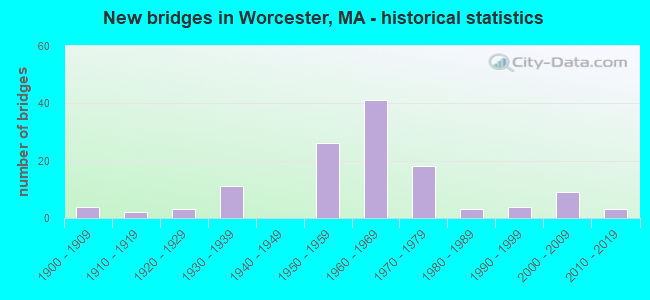
- New bridges - historical statistics
- 41900-1909
- 21910-1919
- 31920-1929
- 111930-1939
- 261950-1959
- 411960-1969
- 181970-1979
- 31980-1989
- 41990-1999
- 92000-2009
- 32010-2019
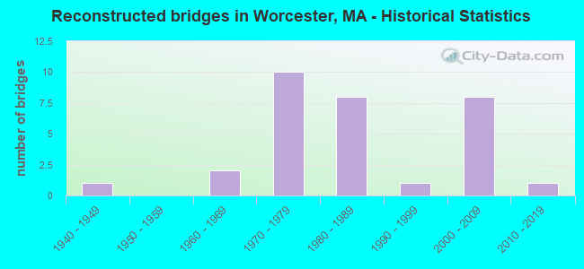
- Reconstructed bridges - Historical Statistics
- 11940-1949
- 01950-1959
- 21960-1969
- 101970-1979
- 81980-1989
- 11990-1999
- 82000-2009
- 12010-2019
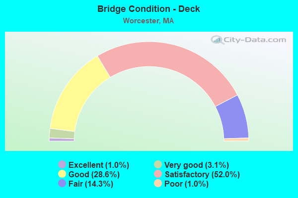
- Bridge Condition - Deck
- 1.0%Excellent
- 3.1%Very good
- 28.6%Good
- 52.0%Satisfactory
- 14.3%Fair
- 1.0%Poor
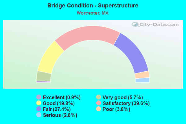
- Bridge Condition - Superstructure
- 0.9%Excellent
- 5.7%Very good
- 19.8%Good
- 39.6%Satisfactory
- 27.4%Fair
- 3.8%Poor
- 2.8%Serious
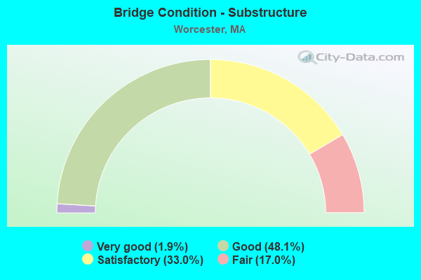
- Bridge Condition - Substructure
- 1.9%Very good
- 48.1%Good
- 33.0%Satisfactory
- 17.0%Fair
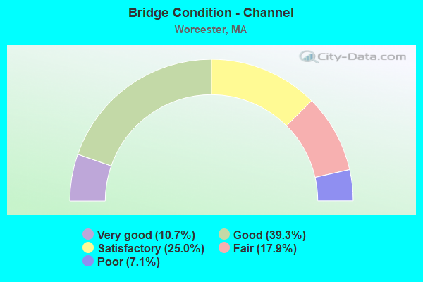
- Bridge Condition - Channel
- 10.7%Very good
- 39.3%Good
- 25.0%Satisfactory
- 17.9%Fair
- 7.1%Poor
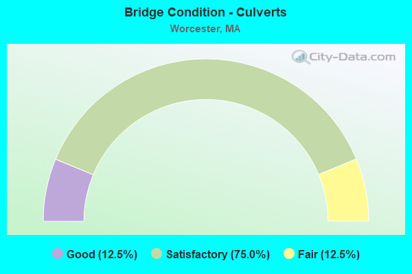
- Bridge Condition - Culverts
- 12.5%Good
- 75.0%Satisfactory
- 12.5%Fair
Find on map >> Show street view
Structure Number: W44156ANPDOTNBI, Location: 500 FT W TOBIAS BOLLD WAY (Lat: 42.227867, Lng: -71.787600), Route carried "on" structure: City street , Year Built: 2001, Status: Open, Structure Length: 7.62m (25.00ft), Average Daily Traffic: 4,635 (year 2018), Truck Traffic: 15%, Average Future Daily Traffic: 14,845 (year 2031), Design Load: HS 20, Features Intersected: WATER BLACKSTONE RIVER, Facility Carried by Structure: HWY BLKSTN RVR R
Minimum Vertical Clearance: 30+ m (98+ ft), Kilometerpoint: 1.290, Lanes on structure: 2, Owner: State Highway Agency, Approaching Roadway Width: 12.2m (40.0ft), Material/Design: Steel continuous, Design/Construction: Box Beam or Girders - Single/Spread, Number Of Spans In Main Unit: 3, Length of Maximum Span: 36.8m (120.7ft), Curb or Sidewalk Widths: Left: 2.1m (6.9ft), Right: 0.0m, Curb-To-Curb Width: 12.2m (40.0ft), Out-to-Out Width: 15.2m (49.9ft)
Condition: Deck: Fair, Superstructure: Good, Substructure: Good, Channel: Fair, Operating Rating: 64.8 metric tons, Method Used To Determine Operating Rating: Load Factor (LF), Inventory Rating: 38.3 metric tons, Method Used To Determine Inventory Rating: Load Factor (LF), Structural Evaluation: Better than present minimum criteria, Deck Geometry: Equal to present minimum criteria, Waterway Adequacy: Equal to present desirable criteria, Approach Roadway Alignment: Equal to present desirable criteria, Length Of Structure Improvement: 7.70m (25.26ft), Designated Inspection Frequency: Every 24 months, Inspection Date: December 2020, Bridge Improvement Cost: $4,549,000, Roadway Improvement Cost: $455,000, Total Project Cost: $6,824,000 ( Estimate for 2022), Deck Structure Type: Concrete Cast-file-Place, Wearing Surface/Protective System: Wearing Surface: Monolithic Concrete, Deck Protection: Epoxy Coated Reinforcing
Find on map >> Show street view
Structure Number: W44157AP1DOTNBI, Location: 40 FT W OF BALLARD ST (Lat: 42.227906, Lng: -71.786331), Route carried "on" structure: City street , Year Built: 2001, Status: Open, Structure Length: 3.86m (12.66ft), Average Daily Traffic: 3,734 (year 2020), Truck Traffic: 7%, Average Future Daily Traffic: 14,530 (year 2033), Design Load: HS 20, Features Intersected: ST146 /ST122A, Facility Carried by Structure: HWY BLKSTN RV RD
Minimum Vertical Clearance: 30+ m (98+ ft), Kilometerpoint: 0.000, Lanes on structure: 4, Lanes under structure: 4, Owner: State Highway Agency, Approaching Roadway Width: 17.1m (56.1ft), Material/Design: Prestressed concrete, Design/Construction: Box Beam or Girders - Single/Spread, Number Of Spans In Main Unit: 2, Length of Maximum Span: 17.8m (58.4ft), Curb or Sidewalk Widths: Left: 3.7m (12.1ft), Right: 0.1m (0.3ft), Curb-To-Curb Width: 17.1m (56.1ft), Out-to-Out Width: 21.6m (70.9ft)
Condition: Deck: Very good, Superstructure: Good, Substructure: Good, Operating Rating: 55.1 metric tons, Method Used To Determine Operating Rating: Load Factor (LF), Inventory Rating: 33.0 metric tons, Method Used To Determine Inventory Rating: Load Factor (LF), Structural Evaluation: Better than present minimum criteria, Deck Geometry: Somewhat better than minimum adequacy, Underclear: Meets minimum limits, Approach Roadway Alignment: Superior to present desirable criteria, Length Of Structure Improvement: 3.90m (12.80ft), Designated Inspection Frequency: Every 24 months, Inspection Date: January 2022, Bridge Improvement Cost: $1,839,000, Roadway Improvement Cost: $184,000, Total Project Cost: $2,759,000 ( Estimate for 2022), Deck Structure Type: Concrete Cast-file-Place, Wearing Surface/Protective System: Wearing Surface: Bituminous, Membrane: Built-up, Deck Protection: Epoxy Coated Reinforcing
Find on map >> Show street view
Structure Number: W44159ATDDOTNBI, Location: .1 MI. WEST OF ST-146 (Lat: 42.235889, Lng: -71.794725), Route carried "on" structure: City street , Year Built: 2005, Status: Open, Structure Length: 3.22m (10.56ft), Average Daily Traffic: 17,934 (year 2017), Truck Traffic: 5%, Average Future Daily Traffic: 31,002 (year 2032), Design Load: HS 20, Features Intersected: COMB BLKSTNE RIV / BKWY, Facility Carried by Structure: HWY MCKEON RD
Minimum Vertical Clearance: 30+ m (98+ ft), Kilometerpoint: 3.240, Lanes on structure: 4, Owner: State Highway Agency, Approaching Roadway Width: 19.5m (64.0ft), Skew: 30 degrees, Material/Design: Prestressed concrete, Design/Construction: Stringer/Multi-beam, Number Of Spans In Main Unit: 1, Length of Maximum Span: 29.6m (97.1ft), Curb or Sidewalk Widths: Left: 0.0m, Right: 2.1m (6.9ft), Curb-To-Curb Width: 19.5m (64.0ft), Out-to-Out Width: 25.4m (83.3ft)
Condition: Deck: Satisfactory, Superstructure: Good, Substructure: Good, Channel: Very good, Inventory Rating: 69.7 metric tons, Method Used To Determine Inventory Rating: Load Factor (LF), Structural Evaluation: Better than present minimum criteria, Deck Geometry: Better than present minimum criteria, Waterway Adequacy: Superior to present desirable criteria, Approach Roadway Alignment: Equal to present desirable criteria, Length Of Structure Improvement: 3.30m (10.83ft), Designated Inspection Frequency: Every 24 months, Inspection Date: January 2021, Bridge Improvement Cost: $809,000, Roadway Improvement Cost: $81,000, Total Project Cost: $1,214,000 ( Estimate for 2022), Deck Structure Type: Concrete Cast-file-Place, Wearing Surface/Protective System: Wearing Surface: Latex Concrete, Deck Protection: Epoxy Coated Reinforcing
Find on map >> Show street view
Structure Number: W44160AUGDOTNBI, Location: 100 FT. S OF CAMBRIDGE ST (Lat: 42.245011, Lng: -71.802847), Route carried "on" structure: Interstate 290, Year Built: 2007, Status: Open, Structure Length: 14.32m (46.98ft), Average Daily Traffic: 145,474 (year 2019), Truck Traffic: 7%, Average Future Daily Traffic: 142,137 (year 2031), Design Load: HS 20, Features Intersected: ST146 MILLBURY ST
Minimum Vertical Clearance: 99.00m (324.80ft), Kilometerpoint: 7.527, Lanes on structure: 6, Lanes under structure: 5, Owner: State Highway Agency, Approaching Roadway Width: 15.8m (51.8ft), Skew: 30 degrees, Material/Design: Steel continuous, Design/Construction: Stringer/Multi-beam, Number Of Spans In Main Unit: 6, Length of Maximum Span: 24.4m (80.1ft), Curb-To-Curb Width: 15.9m (52.2ft), Out-to-Out Width: 34.0m (111.5ft)
Condition: Deck: Good, Superstructure: Good, Substructure: Good, Operating Rating: 92.7 metric tons, Method Used To Determine Operating Rating: Load Factor (LF), Inventory Rating: 55.5 metric tons, Method Used To Determine Inventory Rating: Load Factor (LF), Structural Evaluation: Better than present minimum criteria, Deck Geometry: High priority of replacement, Underclear: High priority of corrective action, Approach Roadway Alignment: Equal to present desirable criteria, Length Of Structure Improvement: 14.40m (47.24ft), Designated Inspection Frequency: Every 24 months, Critical Feature Inspection Frequency: Every 24 months, Inspection Date: September 2020, Critical Feature Inspection Date: September 2020, Bridge Improvement Cost: $18,506,000, Roadway Improvement Cost: $1,851,000, Total Project Cost: $27,760,000 ( Estimate for 2022), Deck Structure Type: Concrete Cast-file-Place, Wearing Surface/Protective System: Wearing Surface: Bituminous, Membrane: Built-up, Deck Protection: Epoxy Coated Reinforcing
Find on map >> Show street view
Structure Number: W44161ATHDOTNBI, Location: 250 FT E. OF BLKSTONE RIV (Lat: 42.236292, Lng: -71.793453), Route carried "on" structure: City street , Year Built: 2005, Status: Open, Structure Length: 4.48m (14.70ft), Average Daily Traffic: 5,110 (year 2016), Truck Traffic: 14%, Average Future Daily Traffic: 7,896 (year 2032), Design Load: HS 20, Features Intersected: ST146 /ST122A & NB ON RP, Facility Carried by Structure: HWY MCKEON RD
Minimum Vertical Clearance: 30+ m (98+ ft), Kilometerpoint: 0.000, Lanes on structure: 5, Lanes under structure: 5, Owner: State Highway Agency, Approaching Roadway Width: 25.0m (82.0ft), Skew: 22 degrees, Material/Design: Prestressed concrete continuous, Design/Construction: Stringer/Multi-beam, Number Of Spans In Main Unit: 2, Length of Maximum Span: 24.4m (80.1ft), Curb or Sidewalk Widths: Left: 0.0m, Right: 2.1m (6.9ft), Curb-To-Curb Width: 23.2m (76.1ft), Out-to-Out Width: 27.9m (91.5ft)
Condition: Deck: Good, Superstructure: Good, Substructure: Good, Operating Rating: 60.9 metric tons, Method Used To Determine Operating Rating: Load Factor (LF), Inventory Rating: 43.4 metric tons, Method Used To Determine Inventory Rating: Load Factor (LF), Structural Evaluation: Better than present minimum criteria, Deck Geometry: Better than present minimum criteria, Underclear: Equal to present minimum criteria, Approach Roadway Alignment: Better than present minimum criteria, Length Of Structure Improvement: 4.50m (14.76ft), Designated Inspection Frequency: Every 24 months, Inspection Date: January 2021, Bridge Improvement Cost: $1,104,000, Roadway Improvement Cost: $111,000, Total Project Cost: $1,657,000 ( Estimate for 2022), Deck Structure Type: Concrete Cast-file-Place, Wearing Surface/Protective System: Wearing Surface: Bituminous, Membrane: Epoxy, Deck Protection: Epoxy Coated Reinforcing
Find on map >> Show street view
Structure Number: W44083212DOTNBI, Location: HARRISON ST/I 290 (Lat: 42.250000, Lng: -71.800000), Route carried "under" structure: Interstate 290, Year Built: 1958, Structure Length: 0. m, Average Daily Traffic: 40,000 (year 0000), Features Intersected: I 290 WB, Facility Carried by Structure: HWY HARRISON ST
Minimum Vertical Clearance: 4.47m (14.67ft), Kilometerpoint: 0.000, Lanes on structure: 3, Lanes under structure: 2, Material/Design: Steel, Design/Construction: Stringer/Multi-beam, Length of Maximum Span: 21.6m (70.9ft)
Find on map >> Show street view
Structure Number: W44083212DOTNBI, Location: HARRISON ST/I 290 (Lat: 42.250000, Lng: -71.800000), Route carried "under" structure: Interstate 290, Year Built: 1958, Structure Length: 0. m, Average Daily Traffic: 40,000 (year 0000), Features Intersected: I 290 EB, Facility Carried by Structure: HWY HARRISON ST
Minimum Vertical Clearance: 4.47m (14.67ft), Kilometerpoint: 0.000, Lanes on structure: 3, Lanes under structure: 2, Material/Design: Steel, Design/Construction: Stringer/Multi-beam, Length of Maximum Span: 21.6m (70.9ft)
Find on map >> Show street view
Structure Number: W440851N9DOTNBI, Location: ST122A VERNON ST/I 290 (Lat: 42.250000, Lng: -71.800000), Route carried "under" structure: Interstate 290, Year Built: 1961, Structure Length: 0. m, Average Daily Traffic: 40,000 (year 0000), Features Intersected: I 290 WB, Facility Carried by Structure: HWY VERNON ST
Minimum Vertical Clearance: 4.83m (15.85ft), Kilometerpoint: 0.000, Lanes on structure: 3, Lanes under structure: 4, Material/Design: Steel, Design/Construction: Stringer/Multi-beam, Length of Maximum Span: 17.7m (58.1ft)
Find on map >> Show street view
Structure Number: W440851N9DOTNBI, Location: ST122A VERNON ST/I 290 (Lat: 42.250000, Lng: -71.800000), Route carried "under" structure: Interstate 290, Year Built: 1965, Structure Length: 0. m, Average Daily Traffic: 40,000 (year 0000), Features Intersected: I 290 EB, Facility Carried by Structure: HWY VERNON ST
Minimum Vertical Clearance: 4.83m (15.85ft), Kilometerpoint: 0.000, Lanes on structure: 3, Lanes under structure: 4, Material/Design: Steel, Design/Construction: Stringer/Multi-beam, Length of Maximum Span: 17.7m (58.1ft)
Find on map >> Show street view
Structure Number: W44093213DOTNBI, Location: LAUREL ST/I290 (Lat: 42.266667, Lng: -71.800000), Route carried "under" structure: Interstate 290, Year Built: 1958, Structure Length: 0. m, Average Daily Traffic: 40,000 (year 0000), Features Intersected: I 290 WB, Facility Carried by Structure: HWY LAUREL ST
Minimum Vertical Clearance: 4.60m (15.09ft), Kilometerpoint: 0.000, Lanes on structure: 3, Lanes under structure: 2, Material/Design: Steel, Design/Construction: Stringer/Multi-beam, Length of Maximum Span: 21.3m (69.9ft)
Find on map >> Show street view
Structure Number: W44093213DOTNBI, Location: LAUREL ST/I290 (Lat: 42.266667, Lng: -71.800000), Route carried "under" structure: Interstate 290, Year Built: 1958, Structure Length: 0. m, Average Daily Traffic: 40,000 (year 0000), Features Intersected: I 290 EB, Facility Carried by Structure: HWY LAUREL ST
Minimum Vertical Clearance: 4.60m (15.09ft), Kilometerpoint: 0.000, Lanes on structure: 3, Lanes under structure: 2, Material/Design: Steel, Design/Construction: Stringer/Multi-beam, Length of Maximum Span: 21.3m (69.9ft)
Find on map >> Show street view
Structure Number: W44097215DOTNBI, Location: BURNCOAT ST/I290 (Lat: 42.283333, Lng: -71.800000), Route carried "under" structure: Interstate 290, Year Built: 1962, Structure Length: 0. m, Average Daily Traffic: 40,000 (year 0000), Features Intersected: I 290 WB, Facility Carried by Structure: HWY BURNCOAT ST
Minimum Vertical Clearance: 4.72m (15.49ft), Kilometerpoint: 0.000, Lanes on structure: 3, Lanes under structure: 4, Material/Design: Steel, Design/Construction: Stringer/Multi-beam, Length of Maximum Span: 18.9m (62.0ft)
Find on map >> Show street view
Structure Number: W44097215DOTNBI, Location: BURNCOAT ST/I290 (Lat: 42.283333, Lng: -71.800000), Route carried "under" structure: Interstate 290, Year Built: 1962, Structure Length: 0. m, Average Daily Traffic: 40,000 (year 0000), Features Intersected: I 290 EB, Facility Carried by Structure: HWY BURNCOAT ST
Minimum Vertical Clearance: 4.72m (15.49ft), Kilometerpoint: 0.000, Lanes on structure: 3, Lanes under structure: 4, Material/Design: Steel, Design/Construction: Stringer/Multi-beam, Length of Maximum Span: 20.7m (67.9ft)
Find on map >> Show street view
Structure Number: W44112216DOTNBI, Location: MARSH AVE/I 290 (Lat: 42.283333, Lng: -71.783333), Route carried "under" structure: Interstate 290, Year Built: 1967, Structure Length: 0. m, Average Daily Traffic: 40,000 (year 0000), Features Intersected: I 290 WB, Facility Carried by Structure: HWY MARSH AVE
Minimum Vertical Clearance: 5.05m (16.57ft), Kilometerpoint: 0.000, Lanes on structure: 3, Lanes under structure: 2, Material/Design: Steel, Design/Construction: Stringer/Multi-beam, Length of Maximum Span: 27.4m (89.9ft)
Find on map >> Show street view
Structure Number: W44112216DOTNBI, Location: MARSH AVE/I 290 (Lat: 42.283333, Lng: -71.783333), Route carried "under" structure: Interstate 290, Year Built: 1967, Structure Length: 0. m, Average Daily Traffic: 40,000 (year 0000), Features Intersected: I 290 EB, Facility Carried by Structure: HWY MARSH AVE
Minimum Vertical Clearance: 5.05m (16.57ft), Kilometerpoint: 0.000, Lanes on structure: 3, Lanes under structure: 2, Material/Design: Steel, Design/Construction: Stringer/Multi-beam, Length of Maximum Span: 27.4m (89.9ft)