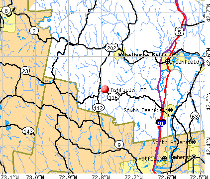
Ashfield, Massachusetts
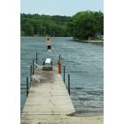
Ashfield: Summer 2012 at Ashfield Lake
Ashfield
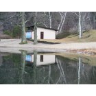
Ashfield: Beach House reflected on Ashfield Lake
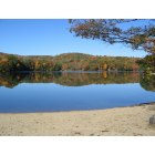
Ashfield: Ashfield Lake in Autumn
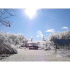
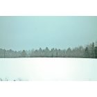
Ashfield: Day after the 2008 Icestorm
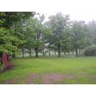
Ashfield: Belding Memorial Park from old Sanderson Academy Field
- add
your
Submit your own pictures of this town and show them to the world
- OSM Map
- General Map
- Google Map
- MSN Map
Population change since 2000: -3.5%
 |
| Males: 853 | |
| Females: 884 |
| Median resident age: | 48.9 years |
| Massachusetts median age: | 39.2 years |
Zip codes: 01330.
| Ashfield: | $91,185 |
| MA: | $94,488 |
Estimated per capita income in 2022: $48,250 (it was $26,483 in 2000)
Ashfield town income, earnings, and wages data
Estimated median house or condo value in 2022: $357,616 (it was $143,900 in 2000)
| Ashfield: | $357,616 |
| MA: | $534,700 |
Mean prices in 2022: all housing units: $313,377; detached houses: $324,224; townhouses or other attached units: $284,225; in 2-unit structures: $287,978; in 3-to-4-unit structures: $183,938; in 5-or-more-unit structures: $249,762; mobile homes: $62,200
Detailed information about poverty and poor residents in Ashfield, MA


- 1,65095.0%White alone
- 321.8%Two or more races
- 311.8%Hispanic
- 80.5%American Indian alone
- 90.5%Asian alone
- 60.3%Black alone
- 10.06%Other race alone
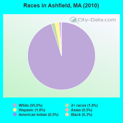
Races in Ashfield detailed stats: ancestries, foreign born residents, place of birth
Type |
2011 |
2012 |
2019 |
2020 |
2021 |
2022 |
|---|---|---|---|---|---|---|
| Murders (per 100,000) | 0 (0.0) | 0 (0.0) | 0 (0.0) | 0 (0.0) | 0 (0.0) | 0 (0.0) |
| Rapes (per 100,000) | 0 (0.0) | 1 (56.9) | 0 (0.0) | 0 (0.0) | 0 (0.0) | 0 (0.0) |
| Robberies (per 100,000) | 0 (0.0) | 0 (0.0) | 0 (0.0) | 0 (0.0) | 0 (0.0) | 0 (0.0) |
| Assaults (per 100,000) | 1 (57.2) | 0 (0.0) | 0 (0.0) | 0 (0.0) | 1 (58.2) | 0 (0.0) |
| Burglaries (per 100,000) | 1 (57.2) | 2 (113.8) | 0 (0.0) | 0 (0.0) | 1 (58.2) | 1 (59.2) |
| Thefts (per 100,000) | 16 (915.3) | 8 (455.3) | 1 (57.7) | 4 (233.2) | 8 (465.7) | 3 (177.5) |
| Auto thefts (per 100,000) | 0 (0.0) | 0 (0.0) | 0 (0.0) | 2 (116.6) | 1 (58.2) | 1 (59.2) |
| Arson (per 100,000) | 0 (0.0) | 0 (0.0) | 0 (0.0) | 0 (0.0) | 0 (0.0) | 1 (59.2) |
| City-Data.com crime index | 52.1 | 71.7 | 2.3 | 18.7 | 39.0 | 16.0 |
The City-Data.com crime index weighs serious crimes and violent crimes more heavily. Higher means more crime, U.S. average is 246.1. It adjusts for the number of visitors and daily workers commuting into cities.
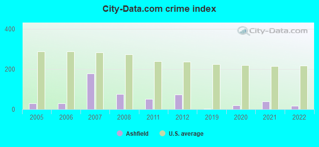
Crime rate in Ashfield detailed stats: murders, rapes, robberies, assaults, burglaries, thefts, arson
Full-time law enforcement employees in 2021, including police officers: 1 (1 officers - 0 male; 1 female).
| Officers per 1,000 residents here: | 0.58 |
| Massachusetts average: | 2.53 |
 Recent articles from our blog. Our writers, many of them Ph.D. graduates or candidates, create easy-to-read articles on a wide variety of topics.

 | Big MA Ancestry Data Thread by Town (31 replies) |
| Is it possible to escape hunters, ATVs and noise in a rural area? (278 replies) |
| Moving to Massachusetts (75 replies) |
| How Much Massachusetts Households Make Per Year: Census Data (37 replies) |
| Old Farm but New Needs (95 replies) |
| Liberal rural towns (103 replies) |
Latest news from Ashfield, MA collected exclusively by city-data.com from local newspapers, TV, and radio stations
Ancestries: English (22.7%), Irish (18.8%), German (14.8%), French (8.7%), Italian (7.3%), Polish (6.9%).
Current Local Time: EST time zone
Incorporated in 1765
Elevation: 1244 feet
Land area: 40.3 square miles.
Population density: 43 people per square mile (very low).
53 residents are foreign born (1.2% Europe, 0.7% North America, 0.6% Latin America, 0.4% Asia).
| This town: | 2.9% |
| Massachusetts: | 12.2% |
| Ashfield town: | 1.4% ($1,986) |
| Massachusetts: | 1.3% ($2,336) |
Nearest city with pop. 50,000+: Chicopee, MA  (26.7 miles , pop. 54,653).
Nearest city with pop. 200,000+: Boston, MA (88.7 miles , pop. 589,141).
Nearest city with pop. 1,000,000+: Bronx, NY (128.3 miles , pop. 1,332,650).
Nearest cities:
), ), ), ), ), Latitude: 42.52 N, Longitude: 72.81 W
Area code: 413

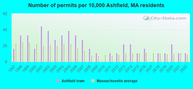
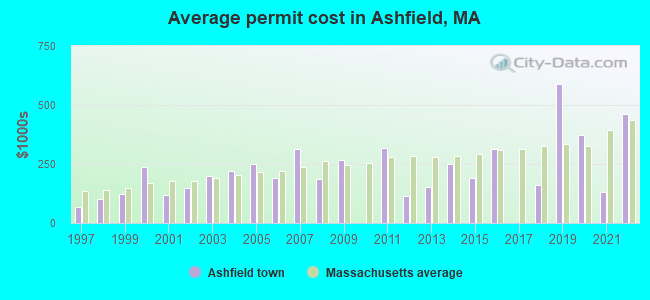
Single-family new house construction building permits:
- 2022: 2 buildings, average cost: $462,500
- 2021: 2 buildings, average cost: $132,300
- 2020: 4 buildings, average cost: $373,800
- 2019: 2 buildings, average cost: $590,000
- 2018: 2 buildings, average cost: $162,500
- 2016: 3 buildings, average cost: $312,100
- 2015: 2 buildings, average cost: $191,000
- 2014: 4 buildings, average cost: $248,800
- 2013: 4 buildings, average cost: $151,800
- 2012: 2 buildings, average cost: $112,500
- 2011: 2 buildings, average cost: $318,200
- 2009: 2 buildings, average cost: $265,300
- 2008: 3 buildings, average cost: $187,100
- 2007: 5 buildings, average cost: $313,000
- 2006: 6 buildings, average cost: $190,300
- 2005: 7 buildings, average cost: $251,000
- 2004: 6 buildings, average cost: $222,200
- 2003: 5 buildings, average cost: $198,300
- 2002: 7 buildings, average cost: $149,300
- 2001: 8 buildings, average cost: $117,700
- 2000: 3 buildings, average cost: $238,800
- 1999: 6 buildings, average cost: $122,000
- 1998: 6 buildings, average cost: $103,200
- 1997: 3 buildings, average cost: $65,500
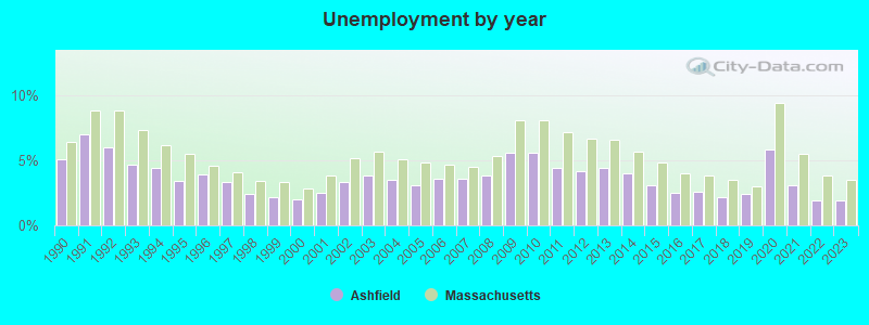
| Here: | 1.9% |
| Massachusetts: | 3.5% |
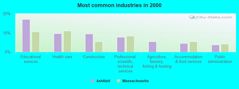
- Educational services (17.1%)
- Health care (9.6%)
- Construction (9.5%)
- Professional, scientific, technical services (7.7%)
- Agriculture, forestry, fishing & hunting (5.4%)
- Accommodation & food services (4.6%)
- Public administration (3.7%)
- Construction (16.1%)
- Educational services (10.7%)
- Professional, scientific, technical services (8.5%)
- Agriculture, forestry, fishing & hunting (8.1%)
- Health care (6.8%)
- Accommodation & food services (3.9%)
- Public administration (3.3%)
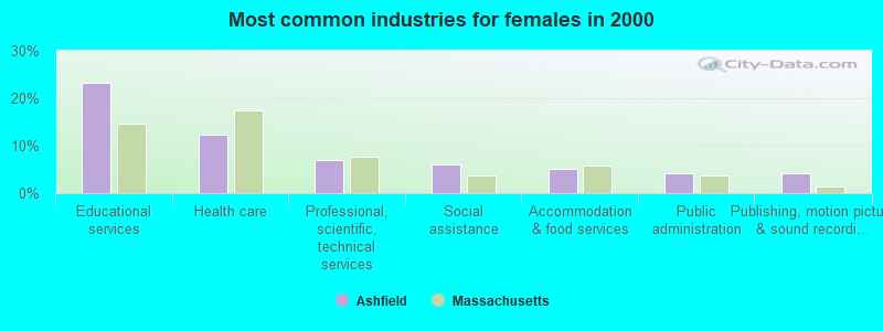
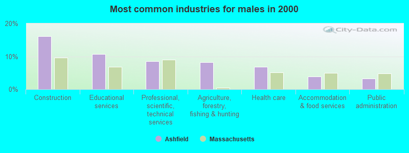
- Educational services (23.3%)
- Health care (12.3%)
- Professional, scientific, technical services (6.9%)
- Social assistance (6.2%)
- Accommodation & food services (5.2%)
- Public administration (4.1%)
- Publishing, motion picture & sound recording industries (4.1%)
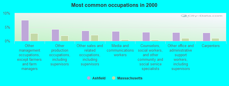
- Other management occupations, except farmers and farm managers (7.5%)
- Other production occupations, including supervisors (4.3%)
- Other sales and related occupations, including supervisors (3.7%)
- Media and communications workers (3.5%)
- Counselors, social workers, and other community and social service specialists (3.2%)
- Other office and administrative support workers, including supervisors (3.1%)
- Carpenters (2.9%)
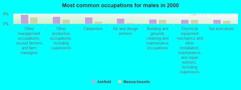
- Other management occupations, except farmers and farm managers (7.6%)
- Other production occupations, including supervisors (5.8%)
- Carpenters (5.4%)
- Art and design workers (4.3%)
- Building and grounds cleaning and maintenance occupations (3.7%)
- Electrical equipment mechanics and other installation, maintenance, and repair workers, including supervisors (3.5%)
- Top executives (3.3%)
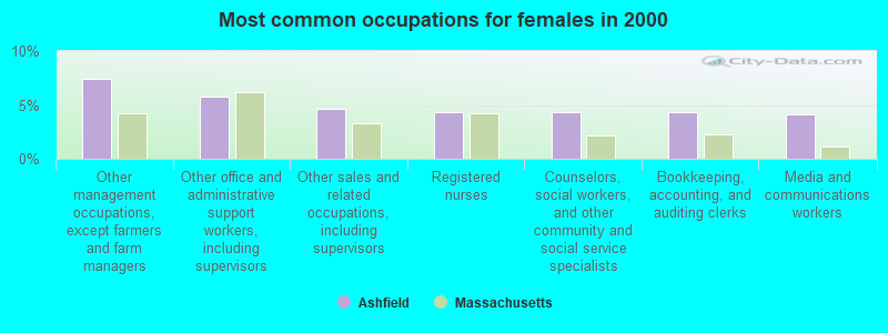
- Other management occupations, except farmers and farm managers (7.5%)
- Other office and administrative support workers, including supervisors (5.8%)
- Other sales and related occupations, including supervisors (4.7%)
- Registered nurses (4.3%)
- Counselors, social workers, and other community and social service specialists (4.3%)
- Bookkeeping, accounting, and auditing clerks (4.3%)
- Media and communications workers (4.1%)
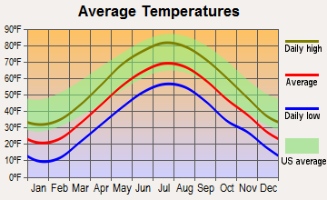
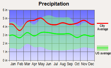
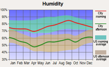
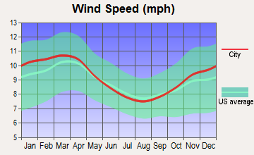
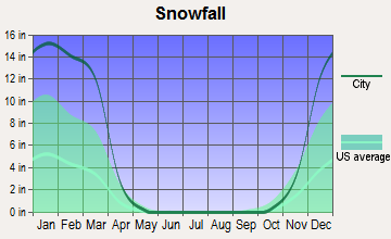
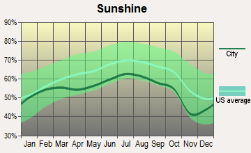
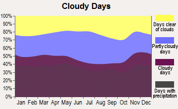
Average climate in Ashfield, Massachusetts
Based on data reported by over 4,000 weather stations
(lower is better)
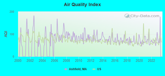
Air Quality Index (AQI) level in 2022 was 69.0. This is about average.
| City: | 69.0 |
| U.S.: | 72.6 |
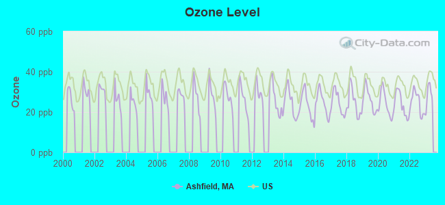
Ozone [ppb] level in 2022 was 24.6. This is better than average. Closest monitor was 11.2 miles away from the city center.
| City: | 24.6 |
| U.S.: | 33.3 |
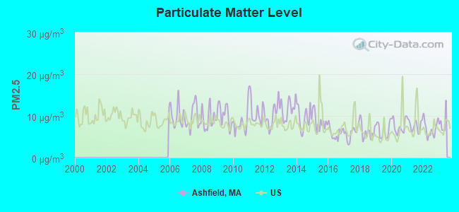
Particulate Matter (PM2.5) [µg/m3] level in 2022 was 6.87. This is about average. Closest monitor was 12.2 miles away from the city center.
| City: | 6.87 |
| U.S.: | 8.11 |
Tornado activity:
Ashfield-area historical tornado activity is above Massachusetts state average. It is 14% smaller than the overall U.S. average.
On 5/29/1995, a category F4 (max. wind speeds 207-260 mph) tornado 30.6 miles away from the Ashfield town center killed 3 people and injured 24 people and caused between $5,000,000 and $50,000,000 in damages.
On 8/28/1973, a category F4 tornado 32.1 miles away from the town center killed 4 people and injured 36 people and caused between $5,000,000 and $50,000,000 in damages.
Earthquake activity:
Ashfield-area historical earthquake activity is significantly above Massachusetts state average. It is 69% smaller than the overall U.S. average.On 10/7/1983 at 10:18:46, a magnitude 5.3 (5.1 MB, 5.3 LG, 5.1 ML, Class: Moderate, Intensity: VI - VII) earthquake occurred 125.7 miles away from the city center
On 4/20/2002 at 10:50:47, a magnitude 5.3 (5.3 ML, Depth: 3.0 mi) earthquake occurred 144.8 miles away from Ashfield center
On 4/20/2002 at 10:50:47, a magnitude 5.2 (5.2 MB, 4.2 MS, 5.2 MW, 5.0 MW) earthquake occurred 143.5 miles away from the city center
On 1/19/1982 at 00:14:42, a magnitude 4.7 (4.5 MB, 4.7 MD, 4.5 LG, Class: Light, Intensity: IV - V) earthquake occurred 91.1 miles away from the city center
On 10/16/2012 at 23:12:25, a magnitude 4.7 (4.7 ML, Depth: 10.0 mi) earthquake occurred 131.7 miles away from Ashfield center
On 6/17/1991 at 08:53:16, a magnitude 4.1 (4.0 MB, 4.0 LG, Depth: 3.1 mi) earthquake occurred 95.7 miles away from the city center
Magnitude types: regional Lg-wave magnitude (LG), body-wave magnitude (MB), duration magnitude (MD), local magnitude (ML), surface-wave magnitude (MS), moment magnitude (MW)
Natural disasters:
The number of natural disasters in Franklin County (20) is greater than the US average (15).Major Disasters (Presidential) Declared: 9
Emergencies Declared: 10
Causes of natural disasters: Floods: 5, Storms: 5, Hurricanes: 4, Snowstorms: 4, Winter Storms: 3, Blizzards: 2, Snows: 2, Snowfall: 1, Tropical Storm: 1, Wind: 1, Other: 1 (Note: some incidents may be assigned to more than one category).
Hospitals and medical centers near Ashfield:
- ANCHORAGE NURSING HOME (Nursing Home, about 9 miles away; SHELBURNE, MA)
- BUCKLEY-GREENFIELD HEALTHCARE CENTER (Nursing Home, about 11 miles away; GREENFIELD, MA)
- CHARLENE MANOR EXTENDED CARE FACILITY (Nursing Home, about 11 miles away; GREENFIELD, MA)
- GENTIVA HEALTH SERVICES (Home Health Center, about 12 miles away; GREENFIELD, MA)
- HOSPICE OF FRANKLIN COUNTY, INC (Hospital, about 12 miles away; GREENFIELD, MA)
- FRANKLIN CENTER (Nursing Home, about 12 miles away; GREENFIELD, MA)
- HOME CARE PRN INC (Home Health Center, about 12 miles away; GREENFIELD, MA)
Colleges/universities with over 2000 students nearest to Ashfield:
- Smith College (about 17 miles; Northampton, MA; Full-time enrollment: 3,549)
- University of Massachusetts-Amherst (about 18 miles; Amherst, MA; FT enrollment: 26,583)
- Mount Holyoke College (about 22 miles; South Hadley, MA; FT enrollment: 2,573)
- Holyoke Community College (about 24 miles; Holyoke, MA; FT enrollment: 4,911)
- Williams College (about 25 miles; Williamstown, MA; FT enrollment: 2,141)
- Westfield State University (about 27 miles; Westfield, MA; FT enrollment: 5,548)
- Springfield Technical Community College (about 31 miles; Springfield, MA; FT enrollment: 4,750)
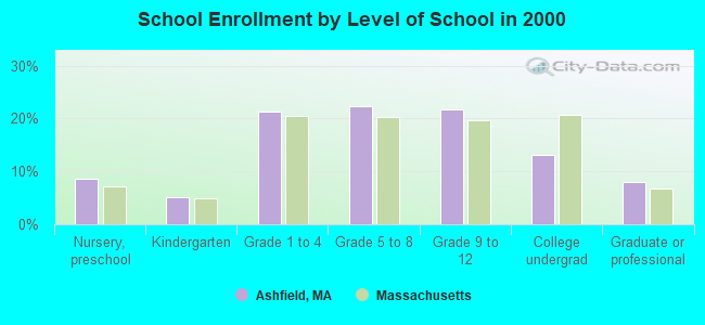
Public elementary/middle school in Ashfield:
- SANDERSON ACADEMY (Students: 145, Location: 808 CAPE STREET, Grades: KG-6)
User-submitted facts and corrections:
- Ashfield has a historical society that maintains a museum and a web site at www.ashfieldhistorical.org Cecil B. DeMillle was indeed born here, but only because his parents happened to be passing through town.
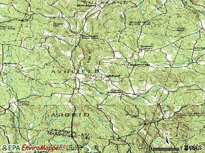
Points of interest:
Notable location: Ashfield Fire Department (A). Display/hide its location on the map
Churches in Ashfield include: Saint Johns Episcopal Church (A), First Congregational Church (B). Display/hide their locations on the map
Cemeteries: Ashfield Plain Cemetery (1), Hill Cemetery (2). Display/hide their locations on the map
Lakes, reservoirs, and swamps: Twining Brook Pond (A), Wauban Pond (B), Ford Pond (C), Upper Reservoir (D), Lower Reservoir (E), Ashfield Pond (F), Williams Pond (G), Bear Swamp (H). Display/hide their locations on the map
Streams, rivers, and creeks: Taylor Brook (A), Billings Brook (B), Ford Brook (C). Display/hide their locations on the map
Birthplace of: William S. Clark - Chemist, Cecil B. DeMille - (1881-1959), movie director, Henry Franklin Kilburn - Architect, Alvan Clark - Astronomer, Henry Clay Payne - Politician, Robert E. Clary - Brigadier general in the Army during the Civil War, Samuel Parker (missionary) - Christian missionary.
Drinking water stations with addresses in Ashfield and their reported violations in the past:
ASHFIELD WATER DISTRICT (Population served: 450, Groundwater):Past health violations:Past monitoring violations:
- MCL, Monthly (TCR) - In JUL-2013, Contaminant: Coliform. Follow-up actions: St AO (w/o penalty) issued (SEP-04-2013)
- 2 regular monitoring violations
| This town: | 2.3 people |
| Massachusetts: | 2.5 people |
| This town: | 62.8% |
| Whole state: | 63.0% |
| This town: | 12.0% |
| Whole state: | 7.0% |
Likely homosexual households (counted as self-reported same-sex unmarried-partner households)
- Lesbian couples: 2.6% of all households
- Gay men: 0.4% of all households
| This town: | 7.6% |
| Whole state: | 9.3% |
| This town: | 2.7% |
| Whole state: | 4.4% |
For population 15 years and over in Ashfield:
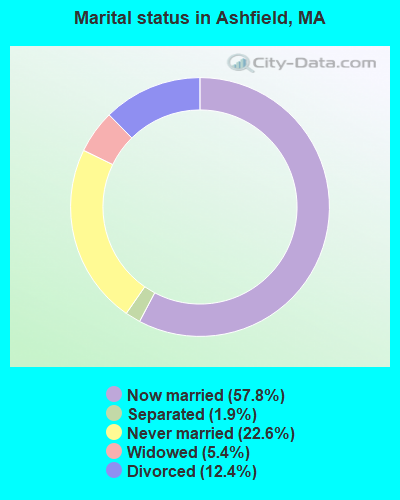
- Never married: 22.6%
- Now married: 57.8%
- Separated: 1.9%
- Widowed: 5.4%
- Divorced: 12.4%
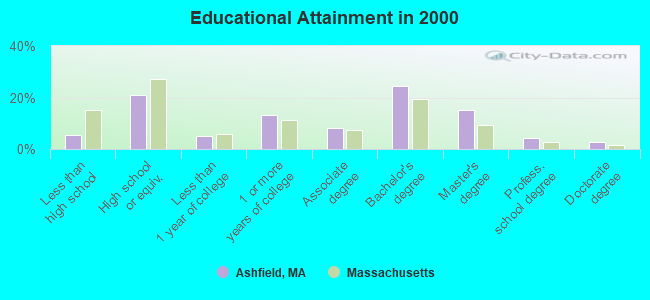
For population 25 years and over in Ashfield:
- High school or higher: 94.5%
- Bachelor's degree or higher: 46.5%
- Graduate or professional degree: 22.2%
- Unemployed: 3.2%
- Mean travel time to work (commute): 32.0 minutes
| Here: | 10.6 |
| Massachusetts average: | 13.1 |


Graphs represent county-level data. Detailed 2008 Election Results
Religion statistics for Ashfield, MA (based on Franklin County data)


| Religion | Adherents | Congregations |
|---|---|---|
| Catholic | 16,509 | 15 |
| Mainline Protestant | 4,617 | 38 |
| Evangelical Protestant | 2,079 | 20 |
| Other | 1,580 | 21 |
| None | 46,587 | - |
Food Environment Statistics:
| Franklin County: | 3.63 / 10,000 pop. |
| Massachusetts: | 1.98 / 10,000 pop. |
| This county: | 0.14 / 10,000 pop. |
| State: | 0.05 / 10,000 pop. |
| Franklin County: | 1.67 / 10,000 pop. |
| Massachusetts: | 2.22 / 10,000 pop. |
| Franklin County: | 3.21 / 10,000 pop. |
| State: | 1.77 / 10,000 pop. |
| Here: | 8.10 / 10,000 pop. |
| State: | 8.76 / 10,000 pop. |
| This county: | 7.5% |
| Massachusetts: | 8.1% |
| Franklin County: | 22.2% |
| Massachusetts: | 22.5% |
| This county: | 15.1% |
| State: | 16.5% |
Strongest AM radio stations in Ashfield:
- WNNZ (640 AM; 50 kW; WESTFIELD, MA; Owner: CLEAR CHANNEL BROADCASTING LICENSES, INC.)
- WIZZ (1520 AM; daytime; 10 kW; GREENFIELD, MA; Owner: P. & M. RADIO, LLC)
- WCRN (830 AM; 50 kW; WORCESTER, MA; Owner: CARTER BROADCASTING CORPORATION)
- WVNE (760 AM; daytime; 25 kW; LEICESTER, MA; Owner: BLOUNT MASSCOM, INC.)
- WTIC (1080 AM; 50 kW; HARTFORD, CT; Owner: INFINITY RADIO OPERATIONS INC.)
- WHYN (560 AM; 5 kW; SPRINGFIELD, MA; Owner: CLEAR CHANNEL BROADCASTING LICENSES, INC.)
- WGY (810 AM; 50 kW; SCHENECTADY, NY; Owner: CLEAR CHANNEL BROADCASTING LICENSES, INC.)
- WPTR (1540 AM; 50 kW; ALBANY, NY; Owner: KIMTRON, INC.)
- WRKO (680 AM; 50 kW; BOSTON, MA; Owner: ENTERCOM BOSTON LICENSE, LLC)
- WACE (730 AM; 5 kW; CHICOPEE, MA; Owner: CARTER BROADCASTING CORP.)
- WALE (990 AM; 50 kW; GREENVILLE, RI; Owner: NORTH AMERICAN BROADCASTING CO., INC.)
- WPNI (1430 AM; 5 kW; AMHERST, MA; Owner: WESTERN MASSACHUSETTS RADIO COMPANY)
- WEEI (850 AM; 50 kW; BOSTON, MA; Owner: ENTERCOM BOSTON LICENSE, LLC)
Strongest FM radio stations in Ashfield:
- WAMC-FM (90.3 FM; ALBANY, NY; Owner: WAMC)
- WRSI (93.9 FM; TURNERS FALLS, MA; Owner: GREAT NORTHERN RADIO, LLC)
- WHAI (98.3 FM; GREENFIELD, MA; Owner: SAGA COMMUNICATIONS OF NEW ENGLAND, LLC)
- WPVQ (95.3 FM; GREENFIELD, MA; Owner: GREAT NORTHERN RADIO, L.L.C.)
- WHYN-FM (93.1 FM; SPRINGFIELD, MA; Owner: CLEAR CHANNEL BROADCASTING LICENSES, INC.)
- WRNX (100.9 FM; AMHERST, MA; Owner: WESTERN MASSACHUSETTS RADIO COMPANY)
- WFCR (88.5 FM; AMHERST, MA; Owner: UNIVERSITY OF MASSACHUSETTS)
- WVAY (100.7 FM; WILMINGTON, VT; Owner: GREAT NORTHERN RADIO, L.L.C.)
- WEQX (102.7 FM; MANCHESTER, VT; Owner: NORTHSHIRE COMMUNICATIONS, INC.)
- WLZX (99.3 FM; NORTHAMPTON, MA; Owner: SAGA COMMUNICATIONS OF NEW ENGLAND, LLC)
- WJAN (95.1 FM; SUNDERLAND, VT; Owner: 6 JOHNSON ROAD LICENSES, INC.)
- WGAJ (91.7 FM; DEERFIELD, MA; Owner: TRUATEES OF DEERFIELD ACADEMY)
- WAMH (89.3 FM; AMHERST, MA; Owner: TRUSTEES OF AMHERST COLLEGE)
- WRSY (101.5 FM; MARLBORO, VT; Owner: GREAT NORTHERN RADIO, L.L.C.)
- WMNB (100.1 FM; NORTH ADAMS, MA; Owner: BERKSHIRE BROADCASTING CO., INC.)
- WEIB (106.3 FM; NORTHAMPTON, MA; Owner: CUTTING EDGE BROADCASTING, INC.)
- WZEC (97.5 FM; HOOSICK FALLS, NY; Owner: GREAT NORTHERN RADIO, LLC)
- W246AM (97.1 FM; AMHERST, MA; Owner: GREAT NORTHERN RADIO, LLC)
- WYRY (104.9 FM; HINSDALE, NH; Owner: TRI-VALLEY BROADCASTING CORPORATION)
- WHDQ (106.1 FM; CLAREMONT, NH; Owner: GREAT NORTHERN RADIO, L.L.C.)
TV broadcast stations around Ashfield:
- W35BK (Channel 35; PLAINFIELD, MA; Owner: LYDIA SYLVANE STOCKWELL)
- WYDN (Channel 48; WORCESTER, MA; Owner: EDUCATIONAL PUBLIC TV CORPORATION)
- WTIC-TV (Channel 61; HARTFORD, CT; Owner: TRIBUNE TELEVISION COMPANY)
- WWLP (Channel 22; SPRINGFIELD, MA; Owner: WWLP BROADCASTING, LLC)
- WCDC-TV (Channel 19; ADAMS, MA; Owner: YOUNG BROADCASTING OF ALBANY, INC.)
Ashfield fatal accident list:
Dec 2, 2004 05:00 AM, Pfersick Rd, Vehicles: 1, Persons: 1, Fatalities: 1
Jun 28, 1992 87:99 PM, West Rd, Vehicles: 1, Persons: 3, Fatalities: 1
Jul 17, 1988 06:40 PM, Rte.112, Vehicles: 2, Persons: 3, Fatalities: 1, Drunk persons involved: 1
Jul 15, 1985 87:99 PM, Baptist Cr, Vehicles: 1, Persons: 1, Fatalities: 1
Jul 23, 1982 09:30 PM, 116, Vehicles: 1, Persons: 1, Fatalities: 1
Apr 30, 1978 03:25 AM, Vehicles: 1, Persons: 2, Fatalities: 1
- National Bridge Inventory (NBI) Statistics
- 13Number of bridges
- 52ft / 15.8mTotal length
- $11,851,000Total costs
- 15,729Total average daily traffic
- 1,153Total average daily truck traffic
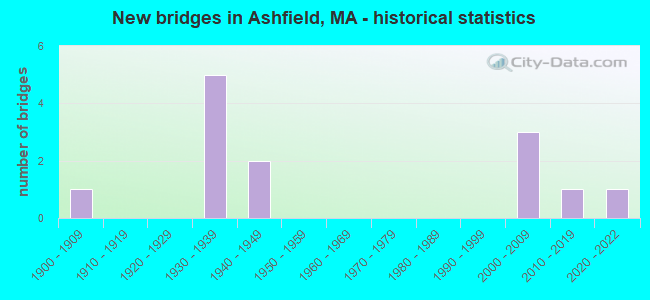
- New bridges - historical statistics
- 11900-1909
- 51930-1939
- 21940-1949
- 32000-2009
- 12010-2019
- 12020-2022
FCC Registered Antenna Towers:
5- Michael J Umano, 1450 Spruce Corner Road (Lat: 42.497556 Lon: -72.841917), Type: 39.6, Structure height: 25011 m, Overall height: 36.5 m, Registrant: Industrial Tower And Wireless, LLC, Kevin.Delaney@induscom.Com, , Marsh-field, Phone: (781) 319-1011
- Michael J Umano, 1450 Spruce Corner Road (Lat: 42.497556 Lon: -72.841917), Type: 39.6, Structure height: 25011 m, Overall height: 36.5 m, Registrant: Industrial Tower And Wireless, LLC, Kevin.Delaney@induscom.Com, , Marsh-field, Phone: (781) 319-1011
- Michael J Umano, 1450 Spruce Corner Road (Lat: 42.497556 Lon: -72.841917), Type: 39.6, Structure height: 25011 m, Overall height: 36.5 m, Licensee ID: L, Registrant: Industrial Tower And Wireless, LLC, Kevin.Delaney@induscom.Com, , Marsh-field, Phone: (781) 319-1011
- Michael J Umano, 1450 Spruce Corner Road (Lat: 42.497556 Lon: -72.841917), Type: 39.6, Structure height: 25011 m, Overall height: 36.5 m, Registrant: Industrial Tower And Wireless, LLC, Kevin.Delaney@itwllc.Com, , Marsh-field, Phone: (781) 319-1011
- Michael J Umano, 1450 Spruce Corner Road (Lat: 42.497556 Lon: -72.841917), Type: 39.6, Structure height: 25011 m, Overall height: 36.5 m, Registrant: Industrial Tower And Wireless, LLC, Kevin.Delaney@itwllc.Com, , Marsh-field, Phone: (781) 319-1011
FCC Registered Broadcast Land Mobile Towers:
2- Ashfield Fire Station Main St (Lat: 42.505083 Lon: -72.810917), Call Sign: KCE577,
Assigned Frequencies: 33.5400 MHz, Grant Date: 05/22/2015, Expiration Date: 06/26/2025, Registrant: Universal Licensing Service, 3419 Via Lido 609, Newport Beach, CA 92663-3908, Phone: (877) 677-3639, Fax: (949) 723-2025
- Highway Carage Route 116 (Lat: 42.521194 Lon: -72.803694), Call Sign: WRD877,
Assigned Frequencies: 154.995 MHz, Grant Date: 04/12/1999, Expiration Date: 06/28/2004, Cancellation Date: 08/29/2004, Registrant: Ashfield, Town Of, Ashfield, MA 01330, Phone: (413) 628-4441
FCC Registered Amateur Radio Licenses:
17 (See the full list of FCC Registered Amateur Radio Licenses in Ashfield)FAA Registered Aircraft:
5- Aircraft: CESSNA 180H (Category: Land, Seats: 6, Weight: Up to 12,499 Pounds, Speed: 121 mph), Engine: CONT MOTOR O-470 SERIES (230 HP) (Reciprocating)
N-Number: 180XB, N180XB, N-180XB, Serial Number: 18052008, Year manufactured: 1969, Airworthiness Date: 05/22/1986, Certificate Issue Date: 10/15/2020
Registrant (Individual): Christian J Chandler, Po Box 555, Ashfield, MA 01330 - Aircraft: CIRRUS DESIGN CORP SR22 (Category: Land, Seats: 4, Weight: Up to 12,499 Pounds), Engine: CONT MOTOR IO-550 SERIES (300 HP) (Reciprocating)
N-Number: 246GM, N246GM, N-246GM, Serial Number: 0260, Year manufactured: 2002, Airworthiness Date: 07/11/2002, Certificate Issue Date: 10/14/2015
Registrant (Corporation): Veteran Flyers Inc, 891 Bug Hill Rd, Ashfield, MA 01330 - Aircraft: PIPER PA-22-150 (Category: Land, Seats: 4, Weight: Up to 12,499 Pounds, Speed: 94 mph), Engine: LYCOMING 0-320 SERIES (180 HP) (Reciprocating)
N-Number: 7734D, N7734D, N-7734D, Serial Number: 22-5411, Year manufactured: 1957, Airworthiness Date: 07/11/1957, Certificate Issue Date: 01/28/2020
Registrant (Individual): Michael F Purcell, 266 Ranney Corner Rd, Ashfield, MA 01330 - Aircraft: BEECH 58 (Category: Land, Engines: 2, Seats: 6, Weight: Up to 12,499 Pounds, Speed: 165 mph), Engine: CONT MOTOR IO-550 SERIES (300 HP) (Reciprocating)
N-Number: 8051U, N8051U, N-8051U, Serial Number: TH-1607, Year manufactured: 1990, Airworthiness Date: 11/28/1990, Certificate Issue Date: 01/14/2016
Registrant (Co-Owned): Christian J Chandler, 278 Watson Spruce Corner Rd, Ashfield, MA 01330, Other Owners: Cara E Chandler - Aircraft: PIPER J3C-65 (Category: Land, Seats: 2, Weight: Up to 12,499 Pounds, Speed: 67 mph), Engine: CONT MOTOR A&C65 SERIES (65 HP) (Reciprocating)
N-Number: 9242K, N9242K, N-9242K, Serial Number: 12019, Year manufactured: 1944, Airworthiness Date: 04/09/1999, Certificate Issue Date: 01/08/2007
Registrant (Individual): Christian J Chandler, Po Box 555, Ashfield, MA 01330
2002 - 2018 National Fire Incident Reporting System (NFIRS) incidents
- Fire incident types reported to NFIRS in Ashfield, MA
- 11456.2%Structure Fires
- 6230.5%Outside Fires
- 157.4%Mobile Property/Vehicle Fires
- 125.9%Other
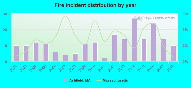 According to the data from the years 2002 - 2018 the average number of fire incidents per year is 12. The highest number of reported fires - 27 took place in 2014, and the least - 2 in 2011. The data has a constant trend.
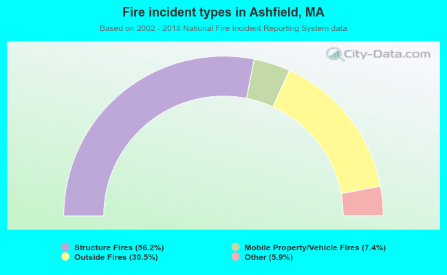 When looking into fire subcategories, the most reports belonged to: Structure Fires (56.2%), and Outside Fires (30.5%).
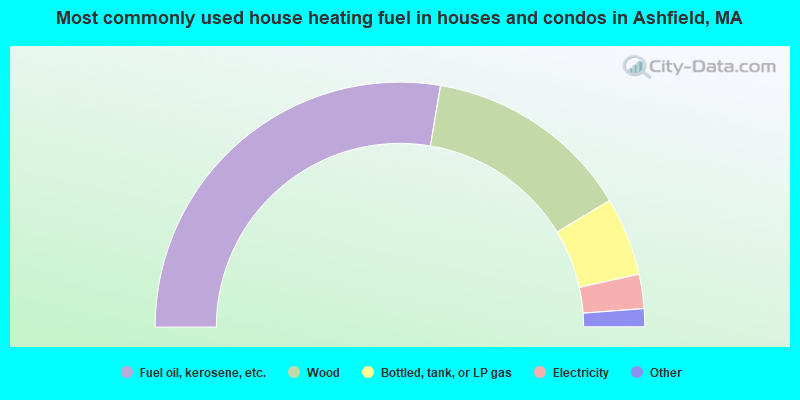
- 55.3%Fuel oil, kerosene, etc.
- 27.4%Wood
- 10.4%Bottled, tank, or LP gas
- 4.5%Electricity
- 1.0%Other fuel
- 0.7%Coal or coke
- 0.3%Utility gas
- 0.3%Solar energy
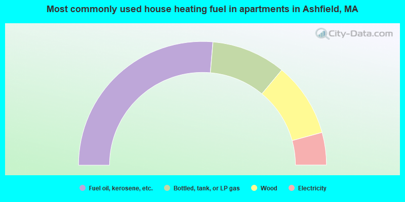
- 52.7%Fuel oil, kerosene, etc.
- 19.4%Bottled, tank, or LP gas
- 19.4%Wood
- 8.5%Electricity
Ashfield compared to Massachusetts state average:
- Unemployed percentage significantly below state average.
- Black race population percentage significantly below state average.
- Hispanic race population percentage significantly below state average.
- Median age significantly above state average.
- Foreign-born population percentage significantly below state average.
- Renting percentage below state average.
- Length of stay since moving in significantly above state average.
- Number of rooms per house significantly below state average.
- House age significantly below state average.

|
Total of 12 patent applications in 2008-2024.