Ashwood, South Carolina
Submit your own pictures of this place and show them to the world
- OSM Map
- General Map
- Google Map
- MSN Map

| Males: 1,769 | |
| Females: 2,001 |
| Median resident age: | 35.5 years |
| South Carolina median age: | 35.4 years |
Zip code: 29040
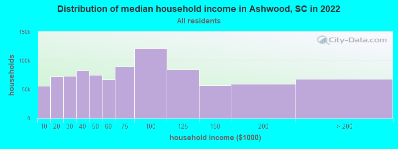
| Ashwood: | $46,293 |
| SC: | $64,115 |
Estimated per capita income in 2022: $20,591 (it was $13,367 in 2000)
Ashwood CCD income, earnings, and wages data
Estimated median house or condo value in 2022: $114,148 (it was $49,400 in 2000)
| Ashwood: | $114,148 |
| SC: | $254,600 |
Detailed information about poverty and poor residents in Ashwood, SC
Compare current foreclosures near Ashwood, SC:
| Photo | Address | Area | Beds / Baths | Price | Details |
|---|---|---|---|---|---|

|
#1
Copley Dr
Sumter, SC 29154
|
1,755 sq. feet
|
2 baths 3 beds |
$170,000
|
show details |

|
#2
Rogers Rd
Cassatt, SC 29032
|
1,463 sq. feet
|
2 baths 3 beds |
$205,000
|
show details |

|
#3
Mclaurin Rd
Wedgefield, SC 29168
|
- sq. feet
|
1 baths 3 beds |
$17,500
|
show details |

|
#4
Carriagebrook Cir
Camden, SC 29020
|
1,655 sq. feet
|
2 baths 3 beds |
show details | |

|
#5
Mcdonald Pl
Bishopville, SC 29010
|
2,046 sq. feet
|
2 baths 4 beds |
show details | |

|
#6
Equinox Ave
Dalzell, SC 29040
|
1,400 sq. feet
|
2 baths 3 beds |
show details | |

|
#7
Calvary Church Rd
Bishopville, SC 29010
|
- sq. feet
|
1 baths 3 beds |
show details | |

|
#8
Genoa Dr
Sumter, SC 29153
|
- sq. feet
|
2 baths 3 beds |
show details | |

|
#9
Shuler Dr
Sumter, SC 29150
|
- sq. feet
|
1 baths 2 beds |
show details | |

|
#10
Bigum St
Dalzell, SC 29040
|
- sq. feet
|
2 baths 3 beds |
show details |
| Photo | Address | Area | Beds / Baths | Price | Details |
|---|---|---|---|---|---|

|
#11
Senate Ln
Sumter, SC 29154
|
- sq. feet
|
2 baths 3 beds |
show details | |

|
#12
Polaris Dr
Sumter, SC 29150
|
- sq. feet
|
2 baths 3 beds |
show details | |

|
#13
Continental Dr
Sumter, SC 29154
|
- sq. feet
|
2 baths 3 beds |
show details | |

|
#14
Trillium Ln
Sumter, SC 29154
|
- sq. feet
|
2 baths 3 beds |
show details | |

|
#15
Watermark Dr
Dalzell, SC 29040
|
- sq. feet
|
2 baths 3 beds |
show details | |

|
#16
Mossberg Dr
Sumter, SC 29150
|
- sq. feet
|
2 baths 4 beds |
show details | |

|
#17
Landmark Dr
Sumter, SC 29154
|
- sq. feet
|
2 baths 2 beds |
show details | |

|
#18
Oleander Dr
Sumter, SC 29154
|
- sq. feet
|
2 baths 3 beds |
show details | |

|
#19
Cutleaf Dr
Sumter, SC 29150
|
- sq. feet
|
2 baths 3 beds |
show details | |

|
#20
Monterey Dr
Sumter, SC 29154
|
- sq. feet
|
2 baths 3 beds |
show details |
| Photo | Address | Area | Beds / Baths | Price | Details |
|---|---|---|---|---|---|

|
#21
Ridge St
Dalzell, SC 29040
|
- sq. feet
|
2 baths 3 beds |
show details | |

|
#22
Crosswell Dr
Sumter, SC 29150
|
- sq. feet
|
2 baths 3 beds |
show details | |

|
#23
Annie St
Dalzell, SC 29040
|
- sq. feet
|
2 baths 3 beds |
show details | |

|
#24
Annie Ct
Dalzell, SC 29040
|
- sq. feet
|
2 baths 3 beds |
show details | |

|
#25
S Magnolia St
Sumter, SC 29150
|
- sq. feet
|
2 baths 3 beds |
show details | |

|
#26
S Wise Dr
Sumter, SC 29150
|
- sq. feet
|
- baths 3 beds |
show details | |

|
#27
Woodlawn Ave
Sumter, SC 29150
|
- sq. feet
|
- baths 3 beds |
show details | |

|
#28
N Lafayette Dr Apt 22
Sumter, SC 29150
|
- sq. feet
|
- baths - beds |
show details | |

|
#29
Brand St
Sumter, SC 29150
|
- sq. feet
|
- baths 3 beds |
show details | |

|
#30
Foxcroft Cir
Sumter, SC 29154
|
- sq. feet
|
- baths - beds |
show details |
| Photo | Address | Area | Beds / Baths | Price | Details |
|---|---|---|---|---|---|

|
#31
Harriett Rd
Sumter, SC 29153
|
- sq. feet
|
- baths 3 beds |
show details | |

|
#32
Ginhouse Dr
Sumter, SC 29154
|
- sq. feet
|
- baths - beds |
show details | |

|
#33
Beacon Dr
Sumter, SC 29154
|
- sq. feet
|
- baths - beds |
show details | |

|
#34
Foxcroft Cir
Sumter, SC 29154
|
- sq. feet
|
- baths - beds |
show details | |

|
#35
Brown Rd
Camden, SC 29020
|
- sq. feet
|
- baths - beds |
show details | |

|
#36
Poulas St # B
Sumter, SC 29150
|
- sq. feet
|
- baths - beds |
show details | |

|
#37
Forest Dr
Sumter, SC 29154
|
- sq. feet
|
- baths 5 beds |
show details | |

|
#38
S Guignard Dr
Sumter, SC 29150
|
- sq. feet
|
- baths - beds |
show details | |

|
#39
Roxbury Ct Apt 203
Sumter, SC 29150
|
- sq. feet
|
- baths - beds |
show details | |

|
#40
Haile St
Sumter, SC 29150
|
- sq. feet
|
- baths 3 beds |
show details |
| Photo | Address | Area | Beds / Baths | Price | Details |
|---|---|---|---|---|---|

|
#41
Dickson Ave
Sumter, SC 29153
|
- sq. feet
|
- baths 2 beds |
show details | |

|
#42
N Guignard Dr
Sumter, SC 29150
|
- sq. feet
|
- baths - beds |
show details | |

|
#43
Shearer Rd
Bishopville, SC 29010
|
- sq. feet
|
- baths - beds |
show details | |

|
#44
Springdale Dr # 312
Camden, SC 29020
|
- sq. feet
|
- baths - beds |
show details | |

|
#45
Wolf Pack Ct Apt 3
Sumter, SC 29150
|
- sq. feet
|
- baths - beds |
show details | |

|
#46
Sweetbriar Rd
Lamar, SC 29069
|
- sq. feet
|
- baths - beds |
show details | |

|
#47
Sandhill Dr
Sumter, SC 29154
|
- sq. feet
|
- baths 3 beds |
show details | |

|
#48
Hilton St
Camden, SC 29020
|
1,221 sq. feet
|
- baths - beds |
show details | |

|
#49
Mineral Cir
Sumter, SC 29153
|
- sq. feet
|
- baths - beds |
show details | |

|
Check over 1 million property listings on Foreclosure.com!
|
browse all offers | |||

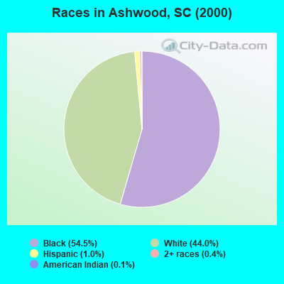
- 2,05554.5%Black alone
- 1,65944.0%White alone
- 361.0%Hispanic
- 140.4%Two or more races
- 40.1%American Indian alone
- 30.08%Asian alone
- 20.05%Other race alone
- 10.03%Native Hawaiian and Other
Pacific Islander alone
Races in Ashwood detailed stats: ancestries, foreign born residents, place of birth
 Recent articles from our blog. Our writers, many of them Ph.D. graduates or candidates, create easy-to-read articles on a wide variety of topics.
Current Local Time: EST time zone
Elevation: 196 feet
Land area: 90.5 square miles.
Population density: 42 people per square mile (very low).

| Ashwood CCD: | 0.8% ($388) |
| South Carolina: | 0.6% ($510) |
Nearest city with pop. 50,000+: Columbia, SC  (36.6 miles , pop. 116,278).
Nearest city with pop. 200,000+: Charlotte, NC (78.0 miles , pop. 540,828).
Nearest city with pop. 1,000,000+: Philadelphia, PA (497.7 miles , pop. 1,517,550).
Nearest cities:
), ), ), ), ), )Latitude: 34.14 N, Longitude: 80.39 W
Area code commonly used in this area: 803

| Here: | 4.1% |
| South Carolina: | 3.1% |
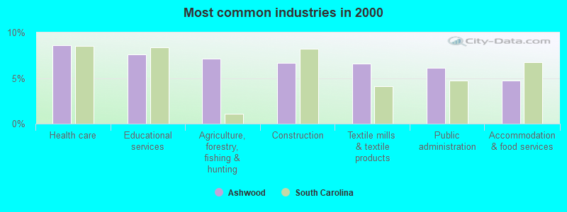
- Health care (8.6%)
- Educational services (7.6%)
- Agriculture, forestry, fishing & hunting (7.1%)
- Construction (6.6%)
- Textile mills & textile products (6.6%)
- Public administration (6.1%)
- Accommodation & food services (4.7%)
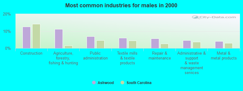
- Construction (12.6%)
- Agriculture, forestry, fishing & hunting (11.2%)
- Public administration (6.9%)
- Textile mills & textile products (6.0%)
- Repair & maintenance (5.6%)
- Administrative & support & waste management services (4.7%)
- Metal & metal products (4.1%)
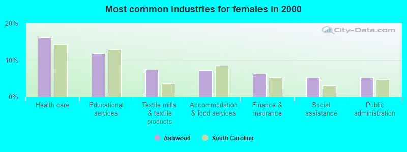
- Health care (16.1%)
- Educational services (11.9%)
- Textile mills & textile products (7.3%)
- Accommodation & food services (7.1%)
- Finance & insurance (6.2%)
- Social assistance (5.2%)
- Public administration (5.2%)
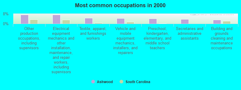
- Other production occupations, including supervisors (7.4%)
- Electrical equipment mechanics and other installation, maintenance, and repair workers, including supervisors (7.3%)
- Textile, apparel, and furnishings workers (4.6%)
- Vehicle and mobile equipment mechanics, installers, and repairers (4.5%)
- Preschool, kindergarten, elementary, and middle school teachers (4.2%)
- Secretaries and administrative assistants (3.6%)
- Building and grounds cleaning and maintenance occupations (3.2%)
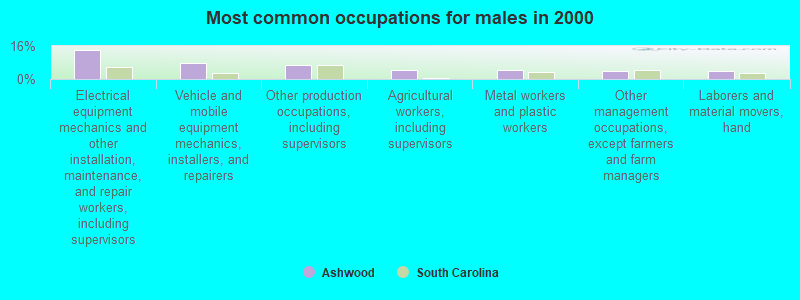
- Electrical equipment mechanics and other installation, maintenance, and repair workers, including supervisors (13.9%)
- Vehicle and mobile equipment mechanics, installers, and repairers (7.9%)
- Other production occupations, including supervisors (6.8%)
- Agricultural workers, including supervisors (4.6%)
- Metal workers and plastic workers (4.2%)
- Other management occupations, except farmers and farm managers (3.9%)
- Laborers and material movers, hand (3.9%)
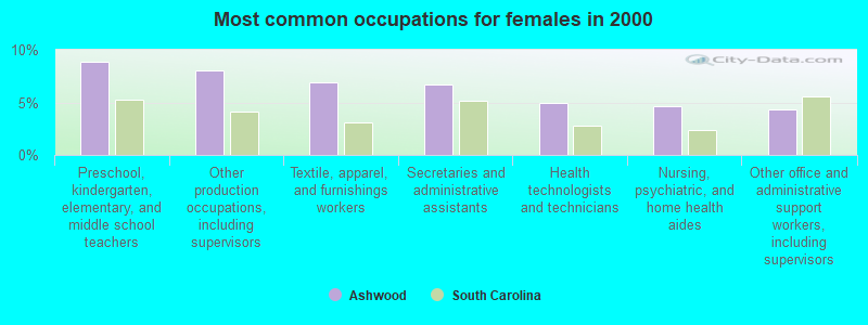
- Preschool, kindergarten, elementary, and middle school teachers (8.8%)
- Other production occupations, including supervisors (8.0%)
- Textile, apparel, and furnishings workers (6.9%)
- Secretaries and administrative assistants (6.7%)
- Health technologists and technicians (5.0%)
- Nursing, psychiatric, and home health aides (4.6%)
- Other office and administrative support workers, including supervisors (4.4%)
Average climate in Ashwood, South Carolina
Based on data reported by over 4,000 weather stations


(lower is better)
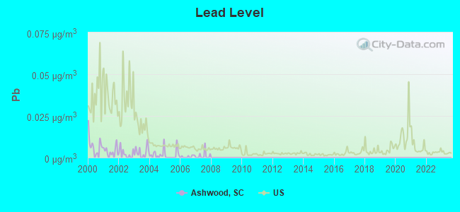
Lead (Pb) [µg/m3] level in 2007 was 0.00111. This is significantly better than average. Closest monitor was 14.7 miles away from the city center.
| City: | 0.00111 |
| U.S.: | 0.00931 |
Tornado activity:
Ashwood-area historical tornado activity is slightly above South Carolina state average. It is 29% greater than the overall U.S. average.
On 3/28/1984, a category F4 (max. wind speeds 207-260 mph) tornado 30.3 miles away from the Ashwood place center injured 36 people and caused between $5,000,000 and $50,000,000 in damages.
On 4/8/1957, a category F4 tornado 35.6 miles away from the place center killed 4 people and injured 70 people.
Earthquake activity:
Ashwood-area historical earthquake activity is significantly above South Carolina state average. It is 36% smaller than the overall U.S. average.On 8/23/2011 at 17:51:04, a magnitude 5.8 (5.8 MW, Depth: 3.7 mi, Class: Moderate, Intensity: VI - VII) earthquake occurred 294.6 miles away from the city center
On 8/2/1974 at 08:52:09, a magnitude 4.9 (4.3 MB, 4.9 LG, Class: Light, Intensity: IV - V) earthquake occurred 121.8 miles away from Ashwood center
On 8/9/2020 at 12:07:37, a magnitude 5.1 (5.1 MW, Depth: 4.7 mi) earthquake occurred 166.4 miles away from the city center
On 11/22/1974 at 05:25:55, a magnitude 4.7 (4.7 MB) earthquake occurred 86.9 miles away from the city center
On 8/21/1992 at 16:31:55, a magnitude 4.4 (4.1 MB, 4.1 LG, 4.4 LG, Depth: 6.2 mi) earthquake occurred 77.0 miles away from Ashwood center
On 4/13/1998 at 09:56:11, a magnitude 3.9 (3.5 MB, 3.9 LG, Depth: 3.1 mi, Class: Light, Intensity: II - III) earthquake occurred 32.8 miles away from the city center
Magnitude types: regional Lg-wave magnitude (LG), body-wave magnitude (MB), moment magnitude (MW)
Natural disasters:
The number of natural disasters in Lee County (15) is near the US average (15).Major Disasters (Presidential) Declared: 8
Emergencies Declared: 5
Causes of natural disasters: Hurricanes: 7, Floods: 3, Storms: 3, Winter Storms: 2, Ice Storm: 1, Tropical Storm: 1, Other: 1 (Note: some incidents may be assigned to more than one category).
Hospitals and medical centers near Ashwood:
- FRESENIUS MEDICAL CARE OF LEE COUNTY (Dialysis Facility, about 10 miles away; BISHOPVILLE, SC)
- LEE COUNTY MEMORIAL HOSPITAL (Hospital, about 10 miles away; BISHOPVILLE, SC)
- MCCOY MEMORIAL NURSING CENTER (Nursing Home, about 10 miles away; BISHOPVILLE, SC)
- MCLEOD II (Hospital, about 10 miles away; BISHOPVILLE, SC)
- COVENANT PLACE NURSING CENTER (Nursing Home, about 13 miles away; SUMTER, SC)
- FRESENIUS MEDICAL CARE SUMTER (Dialysis Facility, about 14 miles away; SUMTER, SC)
- MARINER HEALTH CARE OF SUMTER - WEST (Nursing Home, about 14 miles away; SUMTER, SC)
Colleges/universities with over 2000 students nearest to Ashwood:
- Central Carolina Technical College (about 15 miles; Sumter, SC; Full-time enrollment: 3,108)
- Florence-Darlington Technical College (about 34 miles; Florence, SC; FT enrollment: 4,468)
- Benedict College (about 38 miles; Columbia, SC; FT enrollment: 3,039)
- University of South Carolina-Columbia (about 38 miles; Columbia, SC; FT enrollment: 27,789)
- Francis Marion University (about 43 miles; Florence, SC; FT enrollment: 3,624)
- Midlands Technical College (about 44 miles; West Columbia, SC; FT enrollment: 8,916)
- Orangeburg Calhoun Technical College (about 49 miles; Orangeburg, SC; FT enrollment: 2,113)
Points of interest:
Notable locations in Ashwood: Ashwood Raceway (A), Lee County Rural Fire Department Ashwood (B), Lee County Rural Fire Department Red Hill (C). Display/hide their locations on the map
Churches in Ashwood include: Saint James Church (A), Saint Phillips Church (B), Salem Church (C), Pine Grove Church (D), New Haven Church (E), Bethel Church (F), Mount Olive Church (G), Mount Calvary Church (H), Community Bible Church (I). Display/hide their locations on the map
Cemeteries: Sand Hill Cemetery (1), Rembert Cemetery (2), Whilden Cemetery (3). Display/hide their locations on the map
Lakes, reservoirs, and swamps: Shiver Millpond (A), McLeods Pond (B), Ashwood Lake (C), McGrits Millpond (D), McLeods Upper Pond (E), Corbitts Millpond (F), McLeods Lower Pond (G), Newell Pond (H). Display/hide their locations on the map
Creek: McGirts Creek (A). Display/hide its location on the map
| This place: | 2.5 people |
| South Carolina: | 2.5 people |
| This place: | 70.4% |
| Whole state: | 67.5% |
| This place: | 6.2% |
| Whole state: | 6.0% |
Likely homosexual households (counted as self-reported same-sex unmarried-partner households)
- Lesbian couples: 0.4% of all households
- Gay men: 0.4% of all households
| This place: | 16.0% |
| Whole state: | 14.1% |
| This place: | 7.7% |
| Whole state: | 6.5% |
For population 15 years and over in Ashwood:
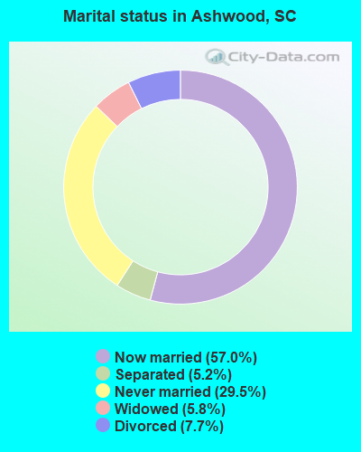
- Never married: 29.5%
- Now married: 57.0%
- Separated: 5.2%
- Widowed: 5.8%
- Divorced: 7.7%
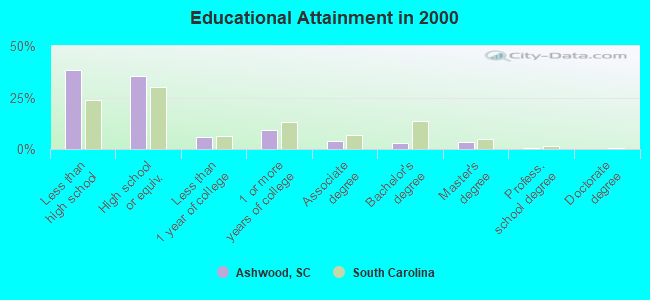
For population 25 years and over in Ashwood:
- High school or higher: 61.9%
- Bachelor's degree or higher: 7.2%
- Graduate or professional degree: 4.1%
- Unemployed: 8.1%
- Mean travel time to work (commute): 28.2 minutes
| Here: | 15.1 |
| South Carolina average: | 13.2 |
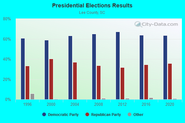
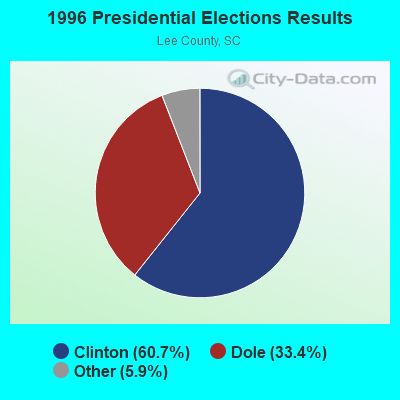
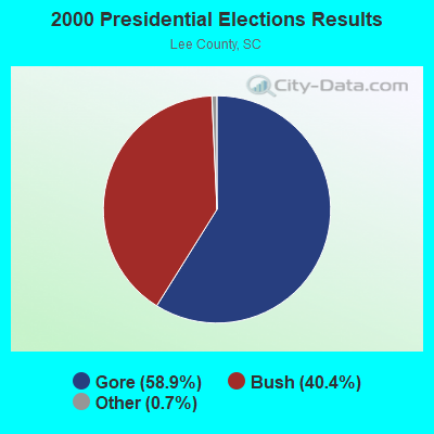
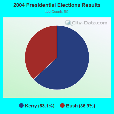
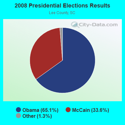
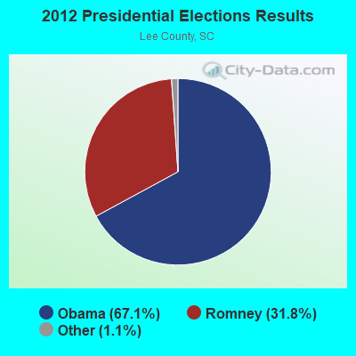
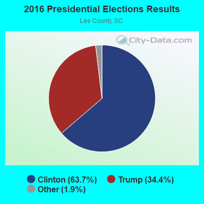
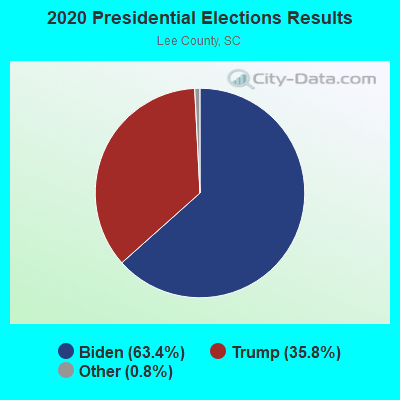
Graphs represent county-level data. Detailed 2008 Election Results
Religion statistics for Ashwood, SC (based on Lee County data)
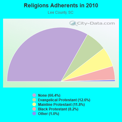
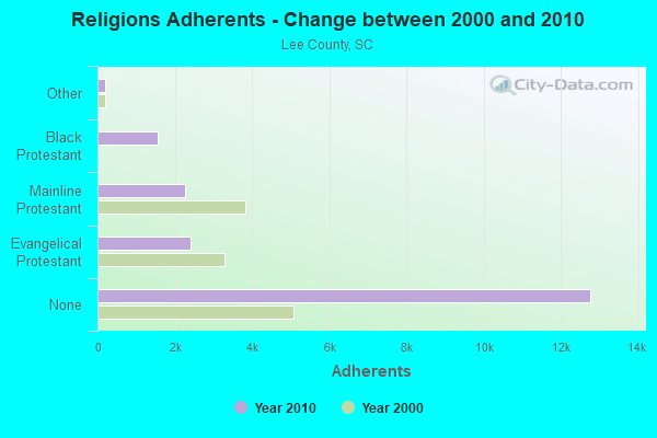
| Religion | Adherents | Congregations |
|---|---|---|
| Evangelical Protestant | 2,421 | 20 |
| Mainline Protestant | 2,261 | 16 |
| Black Protestant | 1,567 | 9 |
| Other | 201 | 1 |
| Catholic | - | - |
| None | 12,770 | - |
Food Environment Statistics:
| Lee County: | 1.50 / 10,000 pop. |
| South Carolina: | 1.99 / 10,000 pop. |
| Lee County: | 0.50 / 10,000 pop. |
| South Carolina: | 0.85 / 10,000 pop. |
| Lee County: | 5.50 / 10,000 pop. |
| State: | 5.38 / 10,000 pop. |
| Here: | 4.00 / 10,000 pop. |
| State: | 7.75 / 10,000 pop. |
| This county: | 14.6% |
| South Carolina: | 10.6% |
| Lee County: | 36.7% |
| South Carolina: | 29.4% |
| This county: | 10.6% |
| State: | 13.4% |
Strongest AM radio stations in Ashwood:
- WCEO (840 AM; daytime; 50 kW; COLUMBIA, SC; Owner: EASTERN BROADCASTING GROUP, INC.)
- WBAJ (890 AM; daytime; 50 kW; BLYTHEWOOD, SC; Owner: FAMILY FIRST)
- WAGL (1560 AM; daytime; 50 kW; LANCASTER, SC; Owner: PALMETTO BROADCASTING SYSTEM, INC.)
- WBT (1110 AM; 50 kW; CHARLOTTE, NC; Owner: JEFFERSON-PILOT COMMUNICATNS CO. OF NORTH CAROLINA)
- WJMX (970 AM; 10 kW; FLORENCE, SC; Owner: QANTUM OF FLORENCE LICENSE COMPANY, LLC)
- WAGS (1380 AM; 1 kW; BISHOPVILLE, SC; Owner: BEAVER COMMUNICATIONS)
- WBCU (1460 AM; 50 kW; UNION, SC)
- WVOC (560 AM; 5 kW; COLUMBIA, SC; Owner: CAPSTAR TX LIMITED PARTNERSHIP)
- WLFJ (660 AM; daytime; 50 kW; GREENVILLE, SC; Owner: CLEAR CHANNEL BROADCASTING LICENSES, INC.)
- WSSC (1340 AM; 1 kW; SUMTER, SC; Owner: SUMTER BAPTIST TEMPLE, INC.)
- WPTF (680 AM; 50 kW; RALEIGH, NC; Owner: FIRST STATE COMMUNICATIONS)
- WLGO (1170 AM; daytime; 10 kW; LEXINGTON, SC; Owner: LEVAS COMMUNICATIONS, LLC)
- WQMC (1290 AM; 1 kW; SUMTER, SC; Owner: MORRIS COLLEGE)
Strongest FM radio stations in Ashwood:
- WWDM (101.3 FM; SUMTER, SC; Owner: URBAN RADIO OF SOUTH CAROLINA, LLC)
- WRJA-FM (88.1 FM; SUMTER, SC; Owner: SOUTH CAROLINA EDUCATIONAL TV COMMISSION)
- WIBZ (95.5 FM; WEDGEFIELD, SC; Owner: MILLER COMMUNICATIONS, INC.)
- W207BQ (89.3 FM; COLUMBIA, SC; Owner: CALVARY CHAPEL OF TWIN FALLS, INC.)
- WNOK (104.7 FM; COLUMBIA, SC; Owner: CAPSTAR TX LIMITED PARTNERSHIP)
- WMHK (89.7 FM; COLUMBIA, SC; Owner: COLUMBIA BIBLE COLLEGE B/CING CO.)
- WCSQ (92.5 FM; MONCKS CORNER, SC; Owner: APEX BROADCASTING, INC.)
- WBZF (98.5 FM; HARTSVILLE, SC; Owner: CUMULUS LICENSING CORP.)
- WLTR (91.3 FM; COLUMBIA, SC; Owner: SOUTH CAROLINA EDUCATIONAL TV COMMISSION)
- WCOS-FM (97.5 FM; COLUMBIA, SC; Owner: CAPSTAR TX LIMITED PARTNERSHIP)
- WPUB-FM (102.7 FM; CAMDEN, SC; Owner: KERSHAW RADIO CORPORATION)
- WTCB (106.7 FM; ORANGEBURG, SC; Owner: CITADEL BROADCASTING COMPANY)
- WWKT-FM (99.3 FM; KINGSTREE, SC; Owner: MILLER COMMUNICATIONS, INC.)
- W205BO (88.9 FM; SUMTER, SC; Owner: PENSACOLA CHRISTIAN COLLEGE, INC.)
- WSIM (93.7 FM; BISHOPVILLE, SC; Owner: MILLER COMMUNICATIONS, INC.)
- W242AH (96.3 FM; SUMTER, SC; Owner: BIBLE BROADCASTING NETWORK, INC.)
TV broadcast stations around Ashwood:
- WOLO-TV (Channel 25; COLUMBIA, SC; Owner: SOUTH CAROLINA BROADCASTING PARTNERS)
- WLTX (Channel 19; COLUMBIA, SC; Owner: PACIFIC AND SOUTHERN COMPANY, INC.)
- WACH (Channel 57; COLUMBIA, SC; Owner: RAYCOM AMERICA, INC.)
- WIS (Channel 10; COLUMBIA, SC; Owner: LIBCO, INC.)
- WRJA-TV (Channel 27; SUMTER, SC; Owner: SOUTH CAROLINA EDUCATIONAL TV COMMISSION)
- WBHQ (Channel 63; SUMTER, SC; Owner: COLUMBIA BROADCASTING, INC.)
- WRLK-TV (Channel 35; COLUMBIA, SC; Owner: SOUTH CAROLINA EDUCATIONAL TV COMMISSION)
- WPDE-TV (Channel 15; FLORENCE, SC; Owner: GRAND STRAND COMMUNICATIONS)
- WWMB (Channel 21; FLORENCE, SC; Owner: ATLANTIC MEDIA GROUP, INC.)
- W66DE (Channel 50; FLORENCE, SC; Owner: CAROLINA CHRISTIAN BROADCASTING, INC.)
- WJPM-TV (Channel 33; FLORENCE, SC; Owner: SOUTH CAROLINA EDUCATIONAL TV COMMISSION)
- WPDF-LP (Channel 56; FLORENCE, SC; Owner: GE MEDIA, INC.)
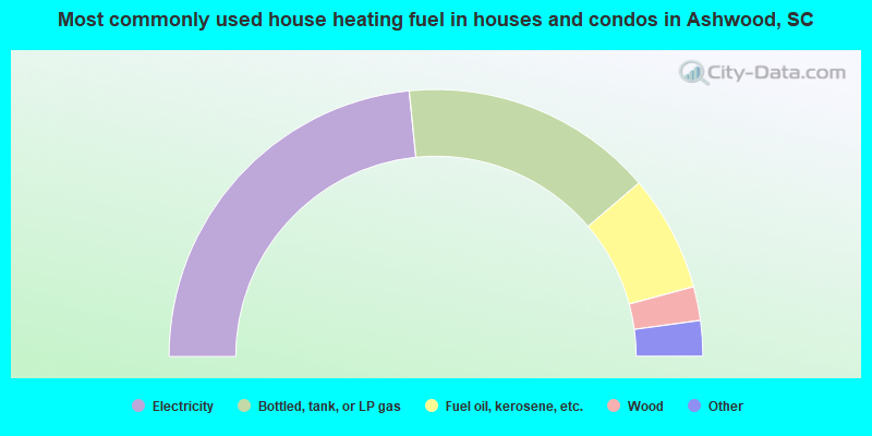
- 46.8%Electricity
- 30.7%Bottled, tank, or LP gas
- 14.1%Fuel oil, kerosene, etc.
- 4.1%Wood
- 2.8%Utility gas
- 1.1%No fuel used
- 0.5%Solar energy
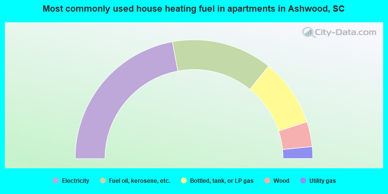
- 44.2%Electricity
- 27.4%Fuel oil, kerosene, etc.
- 18.4%Bottled, tank, or LP gas
- 6.8%Wood
- 3.2%Utility gas
Ashwood compared to South Carolina state average:
- Median house value below state average.
- Unemployed percentage below state average.
- Black race population percentage above state average.
- Hispanic race population percentage significantly below state average.
- Foreign-born population percentage significantly below state average.
- Length of stay since moving in significantly above state average.
- Number of rooms per house significantly below state average.
- House age significantly below state average.
- Percentage of population with a bachelor's degree or higher significantly below state average.