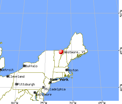
Westmore, Vermont
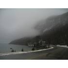
Westmore: fog on willoughby
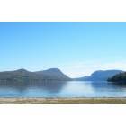
Westmore: Lake Willoughby
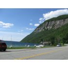
Westmore: ROUTE 5A
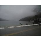
Westmore: South end of Lake Willoughby

Westmore: Overlooking Lake Willoughby from Hinton Hill Rd
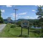
Westmore: Arrival at Westmore via Vermont Rt 5A
- add
your
Submit your own pictures of this town and show them to the world
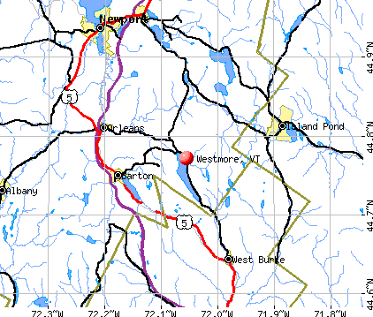
- OSM Map
- General Map
- Google Map
- MSN Map
Population change since 2000: +14.4%
 |
| Males: 178 | |
| Females: 172 |
| Median resident age: | 53.1 years |
| Vermont median age: | 45.8 years |
Zip codes: 05860.
| Westmore: | $56,329 |
| VT: | $73,991 |
Estimated per capita income in 2022: $30,626 (it was $14,522 in 2000)
Westmore town income, earnings, and wages data
Estimated median house or condo value in 2022: $239,516 (it was $89,700 in 2000)
| Westmore: | $239,516 |
| VT: | $304,700 |
Mean prices in 2022: all housing units: $271,502; detached houses: $290,446; townhouses or other attached units: $299,602; in 2-unit structures: $159,589; in 3-to-4-unit structures: $395,771; in 5-or-more-unit structures: $253,965; mobile homes: $74,912
Detailed information about poverty and poor residents in Westmore, VT
Compare current foreclosures near Westmore, VT:
| Photo | Address | Area | Beds / Baths | Price | Details |
|---|---|---|---|---|---|

|
#1
Depot St
West Burke, VT 05871
|
1,320 sq. feet
|
2 baths 2 beds |
$205,000
|
show details |

|
#2
South St
Orleans, VT 05860
|
2,135 sq. feet
|
2 baths 3 beds |
$275,500
|
show details |

|
#3
Salem Derby Rd
Newport, VT 05855
|
- sq. feet
|
1 baths 3 beds |
$129,900
|
show details |

|
#4
Pepin Rd
Orleans, VT 05860
|
952 sq. feet
|
1 baths 1 beds |
show details | |

|
#5
Ponemah Path
West Burke, VT 05871
|
- sq. feet
|
- baths - beds |
show details | |

|
#6
Hinman Rd
Glover, VT 05839
|
- sq. feet
|
- baths - beds |
show details | |

|
#7
Vt Route 14 N
Newport, VT 05855
|
- sq. feet
|
- baths - beds |
show details | |

|
#8
Depot St
West Burke, VT 05871
|
- sq. feet
|
- baths - beds |
show details | |

|
#9
Mount Vernon St
Newport, VT 05855
|
- sq. feet
|
- baths - beds |
show details | |

|
Check over 1 million property listings on Foreclosure.com!
|
browse all offers | |||

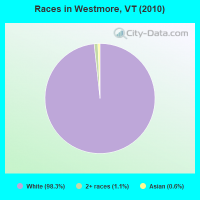
- 34498.3%White alone
- 41.1%Two or more races
- 20.6%Asian alone
Races in Westmore detailed stats: ancestries, foreign born residents, place of birth
 Recent articles from our blog. Our writers, many of them Ph.D. graduates or candidates, create easy-to-read articles on a wide variety of topics.

 | Driving Thru Vermont-Mountain Recommendation(s) (12 replies) |
| Vermont Weather (3779 replies) |
| Official Vermont Picture Thread (966 replies) |
| How is the Barton/Westmore area to live in? (4 replies) |
| Late May in VT (25 replies) |
| What is so GREAT about VT (252 replies) |
Latest news from Westmore, VT collected exclusively by city-data.com from local newspapers, TV, and radio stations
Ancestries: English (37.6%), French (19.6%), German (11.1%), Irish (11.1%), French Canadian (10.8%), United States (10.5%).
Current Local Time: EST time zone
Elevation: 1197 feet
Land area: 34.5 square miles.
Population density: 10 people per square mile (very low).
3 residents are foreign born
| This town: | 1.0% |
| Vermont: | 3.8% |
| Westmore town: | 1.4% ($1,226) |
| Vermont: | 2.0% ($2,196) |
Nearest city with pop. 50,000+: Portland, ME  (115.3 miles , pop. 64,249).
Nearest city with pop. 200,000+: Boston, MA (174.9 miles , pop. 589,141).
Nearest city with pop. 1,000,000+: Bronx, NY (286.2 miles , pop. 1,332,650).
Nearest cities:
), ), ), ), )Latitude: 44.76 N, Longitude: 72.03 W
Area code commonly used in this area: 802

Single-family new house construction building permits:
- 2014: 1 building, cost: $241,400
- 2013: 1 building, cost: $233,900
- 2012: 1 building, cost: $236,600
- 2011: 2 buildings, average cost: $172,800
- 2010: 2 buildings, average cost: $165,900
- 2009: 11 buildings, average cost: $178,900
- 2008: 3 buildings, average cost: $182,400
- 2007: 5 buildings, average cost: $145,700
- 2006: 4 buildings, average cost: $134,000
- 2005: 6 buildings, average cost: $133,300
- 2004: 2 buildings, average cost: $50,000
- 2003: 4 buildings, average cost: $45,000
- 2002: 7 buildings, average cost: $81,700
- 2001: 6 buildings, average cost: $81,700
- 2000: 6 buildings, average cost: $81,700
- 1999: 7 buildings, average cost: $65,700
- 1998: 7 buildings, average cost: $65,700
- 1997: 7 buildings, average cost: $65,700
| Here: | 2.3% |
| Vermont: | 2.0% |
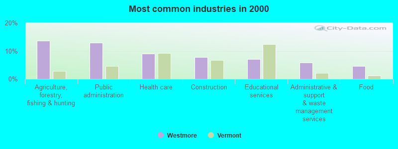
- Agriculture, forestry, fishing & hunting (13.6%)
- Public administration (13.0%)
- Health care (9.1%)
- Construction (7.8%)
- Educational services (7.1%)
- Administrative & support & waste management services (5.8%)
- Food (4.5%)
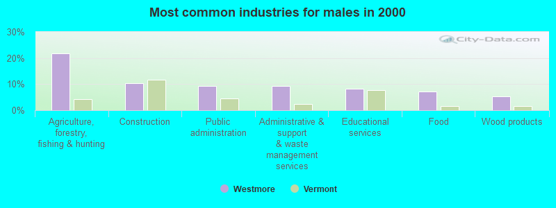
- Agriculture, forestry, fishing & hunting (21.9%)
- Construction (10.4%)
- Public administration (9.4%)
- Administrative & support & waste management services (9.4%)
- Educational services (8.3%)
- Food (7.3%)
- Wood products (5.2%)
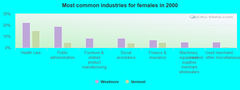
- Health care (22.4%)
- Public administration (19.0%)
- Furniture & related product manufacturing (8.6%)
- Social assistance (8.6%)
- Finance & insurance (6.9%)
- Machinery, equipment, supplies merchant wholesalers (5.2%)
- Used merchandise, gift, novelty, souvenir, other miscellaneous stores (5.2%)
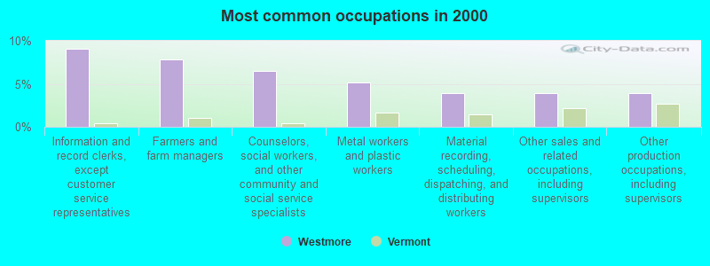
- Information and record clerks, except customer service representatives (9.1%)
- Farmers and farm managers (7.8%)
- Counselors, social workers, and other community and social service specialists (6.5%)
- Metal workers and plastic workers (5.2%)
- Material recording, scheduling, dispatching, and distributing workers (3.9%)
- Other sales and related occupations, including supervisors (3.9%)
- Other production occupations, including supervisors (3.9%)
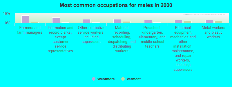
- Farmers and farm managers (12.5%)
- Information and record clerks, except customer service representatives (9.4%)
- Other protective service workers, including supervisors (6.2%)
- Material recording, scheduling, dispatching, and distributing workers (6.2%)
- Preschool, kindergarten, elementary, and middle school teachers (5.2%)
- Electrical equipment mechanics and other installation, maintenance, and repair workers, including supervisors (5.2%)
- Metal workers and plastic workers (5.2%)
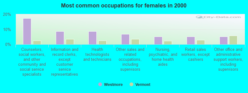
- Counselors, social workers, and other community and social service specialists (17.2%)
- Information and record clerks, except customer service representatives (8.6%)
- Health technologists and technicians (8.6%)
- Other sales and related occupations, including supervisors (6.9%)
- Nursing, psychiatric, and home health aides (5.2%)
- Retail sales workers, except cashiers (5.2%)
- Other office and administrative support workers, including supervisors (5.2%)
Average climate in Westmore, Vermont
Based on data reported by over 4,000 weather stations


Earthquake activity:
Westmore-area historical earthquake activity is significantly above Vermont state average. It is 77% smaller than the overall U.S. average.On 4/20/2002 at 10:50:47, a magnitude 5.3 (5.3 ML, Depth: 3.0 mi, Class: Moderate, Intensity: VI - VII) earthquake occurred 84.0 miles away from Westmore center
On 4/20/2002 at 10:50:47, a magnitude 5.2 (5.2 MB, 4.2 MS, 5.2 MW, 5.0 MW) earthquake occurred 85.4 miles away from the city center
On 10/7/1983 at 10:18:46, a magnitude 5.3 (5.1 MB, 5.3 LG, 5.1 ML) earthquake occurred 127.3 miles away from the city center
On 1/19/1982 at 00:14:42, a magnitude 4.7 (4.5 MB, 4.7 MD, 4.5 LG, Class: Light, Intensity: IV - V) earthquake occurred 89.5 miles away from Westmore center
On 10/16/2012 at 23:12:25, a magnitude 4.7 (4.7 ML, Depth: 10.0 mi) earthquake occurred 105.1 miles away from Westmore center
On 6/16/1995 at 12:13:11, a magnitude 3.8 (3.8 LG, Depth: 3.1 mi, Class: Light, Intensity: II - III) earthquake occurred 33.0 miles away from the city center
Magnitude types: regional Lg-wave magnitude (LG), body-wave magnitude (MB), duration magnitude (MD), local magnitude (ML), surface-wave magnitude (MS), moment magnitude (MW)
Natural disasters:
The number of natural disasters in Orleans County (23) is greater than the US average (15).Major Disasters (Presidential) Declared: 17
Emergencies Declared: 2
Causes of natural disasters: Floods: 16, Storms: 14, Tropical Storms: 2, Winds: 2, Winter Storms: 2, Heavy Rain: 1, Hurricane: 1, Landslide: 1, Snowstorm: 1, Tornado: 1, Other: 1 (Note: some incidents may be assigned to more than one category).
Colleges/universities with over 2000 students nearest to Westmore:
- Norwich University (about 53 miles; Northfield, VT; Full-time enrollment: 4,221)
- Saint Michael's College (about 59 miles; Colchester, VT; FT enrollment: 2,336)
- Community College of Vermont (about 60 miles; Winooski, VT; FT enrollment: 3,394)
- University of Vermont (about 61 miles; Burlington, VT; FT enrollment: 11,566)
- Champlain College (about 62 miles; Burlington, VT; FT enrollment: 2,623)
- SUNY College at Plattsburgh (about 71 miles; Plattsburgh, NY; FT enrollment: 5,934)
- Plymouth State University (about 72 miles; Plymouth, NH; FT enrollment: 4,838)
Points of interest:
Notable locations in Westmore: Songadeewin Camp (A), White Caps Campground (B), Westmore Fire and Rescue (C). Display/hide their locations on the map
Cemetery: Lakeview Cemetery (1). Display/hide its location on the map
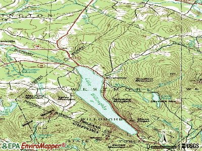
Lakes: Lake Willoughby (A), Brown Pond (B), Jobs Pond (C), Bald Hill Pond (D), Long Pond (E), Negro Pond (F), Mud Pond (G). Display/hide their locations on the map
Streams, rivers, and creeks: Mill Brook (A), Arcadia Brook (B), Richies Run (C). Display/hide their locations on the map
Park in Westmore: Bald Hill Wildlife Management Area (1). Display/hide its location on the map
Drinking water stations with addresses in Westmore and their reported violations in the past:
WHITE CAPS CAMPGROUND (Address: 5659 RT 5A , Population served: 102, Groundwater):Past health violations:WILLOUGHVALE INN (Address: 793 VT ROUTE 5A , Population served: 37, Groundwater):Past monitoring violations:
- MCL, Monthly (TCR) - In MAY-2008, Contaminant: Coliform. Follow-up actions: St Boil Water Order (MAY-20-2008), St Formal NOV issued (MAY-20-2008), St Tech Assistance Visit (MAY-20-2008), St Public Notif requested (MAY-20-2008), St Compliance achieved (SEP-25-2009)
- MCL, Monthly (TCR) - In OCT-2007, Contaminant: Coliform. Follow-up actions: St Public Notif requested (OCT-10-2007), St Formal NOV issued (OCT-10-2007), St Public Notif received (3 times from MAY-16-2008 to MAY-16-2008), St Compliance achieved (SEP-25-2009)
- Monitoring, Repeat Major (TCR) - Between JUL-2007 and SEP-2007, Contaminant: Coliform (TCR). Follow-up actions: St Public Notif requested (OCT-24-2007), St Formal NOV issued (OCT-24-2007), St Public Notif received (3 times from MAY-16-2008 to MAY-16-2008), St Compliance achieved (SEP-25-2009)
- One routine major monitoring violation
- One regular monitoring violation
Past health violations:Past monitoring violations:
- MCL, Monthly (TCR) - In OCT-2012, Contaminant: Coliform. Follow-up actions: St Tech Assistance Visit (OCT-29-2012), St Formal NOV issued (OCT-29-2012), St Boil Water Order (OCT-29-2012), St Public Notif requested (OCT-29-2012), St Public Notif received (DEC-04-2012), St Compliance achieved (MAR-15-2013)
- MCL, Monthly (TCR) - In MAY-2012, Contaminant: Coliform. Follow-up actions: St Tech Assistance Visit (MAY-18-2012), St Formal NOV issued (MAY-18-2012), St Public Notif requested (MAY-18-2012), St Boil Water Order (MAY-18-2012), St Compliance achieved (JUL-13-2012)
- MCL, Monthly (TCR) - In JUN-2008, Contaminant: Coliform. Follow-up actions: St Boil Water Order (JUN-18-2008), St Formal NOV issued (JUN-18-2008), St Tech Assistance Visit (JUN-18-2008), St Public Notif requested (JUN-18-2008), St Compliance achieved (SEP-25-2009)
- MCL, Monthly (TCR) - Between JAN-2007 and MAR-2007, Contaminant: Coliform. Follow-up actions: St Formal NOV issued (JAN-25-2007), St Public Notif requested (JAN-25-2007), St Public Notif received (FEB-14-2007), St Compliance achieved (SEP-25-2009)
- Monitoring, Source Water (GWR) - In OCT-19-2012, Contaminant: E. COLI. Follow-up actions: St Public Notif requested (DEC-21-2012), St Formal NOV issued (DEC-21-2012), St Compliance achieved (MAY-22-2013)
- Monitoring, Repeat Major (TCR) - Between OCT-2012 and DEC-2012, Contaminant: Coliform (TCR). Follow-up actions: St Public Notif requested (JAN-28-2013), St Formal NOV issued (JAN-28-2013), St Compliance achieved (MAY-22-2013)
- Monitoring, Repeat Major (TCR) - Between JUL-2011 and SEP-2011, Contaminant: Coliform (TCR). Follow-up actions: St Public Notif requested (DEC-12-2011), St Formal NOV issued (DEC-12-2011), St Compliance achieved (NOV-12-2013)
- Monitoring, Repeat Major (TCR) - Between JUL-2009 and SEP-2009, Contaminant: Coliform (TCR). Follow-up actions: St Formal NOV issued (NOV-02-2009), St Public Notif requested (NOV-02-2009), St Public Notif received (NOV-12-2009), St Compliance achieved (NOV-12-2013)
- 10 routine major monitoring violations
- One minor monitoring violation
- One regular monitoring violation
| This town: | 2.1 people |
| Vermont: | 2.3 people |
| This town: | 63.6% |
| Whole state: | 62.5% |
| This town: | 7.9% |
| Whole state: | 9.2% |
No gay or lesbian households reported
| This town: | 14.6% |
| Whole state: | 9.4% |
| This town: | 0.6% |
| Whole state: | 3.6% |
For population 15 years and over in Westmore:
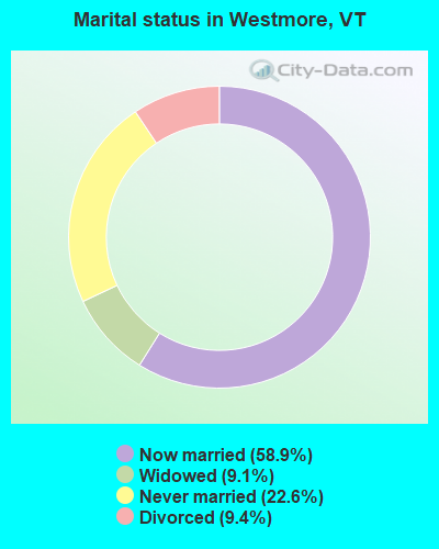
- Never married: 22.6%
- Now married: 58.9%
- Separated: 0.0%
- Widowed: 9.1%
- Divorced: 9.4%
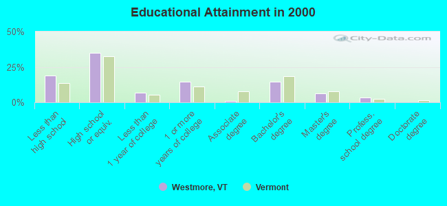
For population 25 years and over in Westmore:
- High school or higher: 81.3%
- Bachelor's degree or higher: 24.0%
- Graduate or professional degree: 9.3%
- Unemployed: 2.5%
- Mean travel time to work (commute): 23.4 minutes
| Here: | 11.9 |
| Vermont average: | 11.7 |
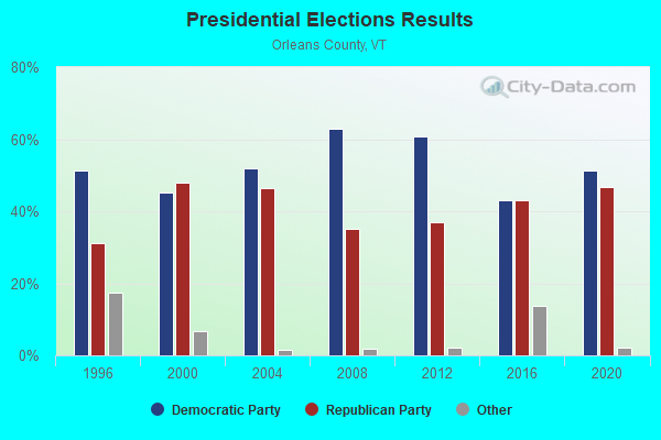
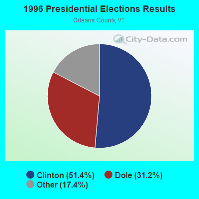
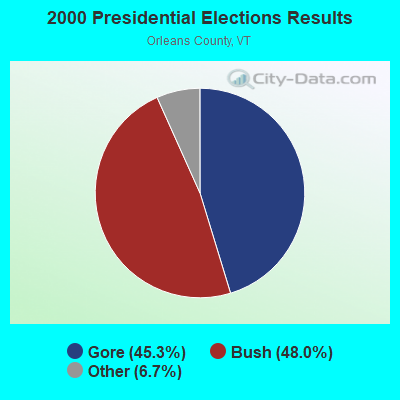
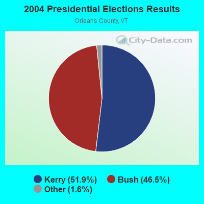
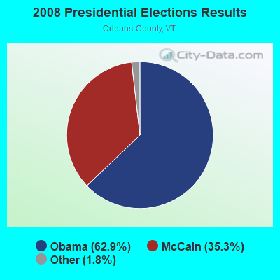
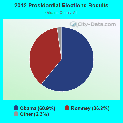
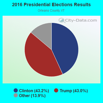
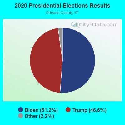
Graphs represent county-level data. Detailed 2008 Election Results
Religion statistics for Westmore, VT (based on Orleans County data)
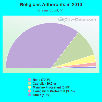
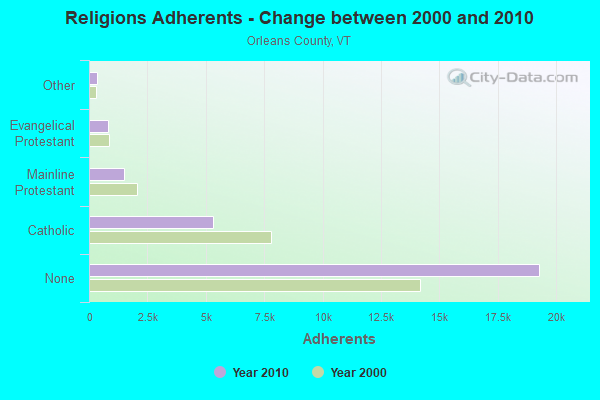
| Religion | Adherents | Congregations |
|---|---|---|
| Catholic | 5,312 | 12 |
| Mainline Protestant | 1,485 | 23 |
| Evangelical Protestant | 822 | 14 |
| Other | 323 | 4 |
| None | 19,289 | - |
Food Environment Statistics:
| Orleans County: | 5.14 / 10,000 pop. |
| Vermont: | 3.84 / 10,000 pop. |
| Here: | 1.10 / 10,000 pop. |
| State: | 1.95 / 10,000 pop. |
| Here: | 6.60 / 10,000 pop. |
| Vermont: | 6.40 / 10,000 pop. |
| Orleans County: | 8.07 / 10,000 pop. |
| Vermont: | 11.52 / 10,000 pop. |
| Here: | 7.0% |
| State: | 6.8% |
| Here: | 24.8% |
| Vermont: | 22.3% |
| Orleans County: | 10.8% |
| Vermont: | 13.3% |
Strongest AM radio stations in Westmore:
- WCHP (760 AM; 35 kW; CHAMPLAIN, NY; Owner: CHAMPLAIN RADIO, INC.)
- WDEV (550 AM; 5 kW; WATERBURY, VT; Owner: RADIO VERMONT, INC.)
- WICY (1490 AM; 50 kW; MALONE, NY; Owner: CARTIER COMMUNICATIONS INC.)
- WRKO (680 AM; 50 kW; BOSTON, MA; Owner: ENTERCOM BOSTON LICENSE, LLC)
- WIKE (1490 AM; 1 kW; NEWPORT, VT; Owner: NORTHSTAR MEDIA, INC.)
- WTWN (1100 AM; daytime; 5 kW; WELLS RIVER, VT; Owner: PUFFER BROADCASTING, INC.)
- WNNZ (640 AM; 50 kW; WESTFIELD, MA; Owner: CLEAR CHANNEL BROADCASTING LICENSES, INC.)
- WTME (780 AM; 10 kW; RUMFORD, ME; Owner: MOUNTAIN VALLEY BROADCASTING, INC.)
- WGY (810 AM; 50 kW; SCHENECTADY, NY; Owner: CLEAR CHANNEL BROADCASTING LICENSES, INC.)
- WVMT (620 AM; 5 kW; BURLINGTON, VT; Owner: SISON BROADCASTING, INC.)
- WCRN (830 AM; 50 kW; WORCESTER, MA; Owner: CARTER BROADCASTING CORPORATION)
- WEEI (850 AM; 50 kW; BOSTON, MA; Owner: ENTERCOM BOSTON LICENSE, LLC)
- WBZ (1030 AM; 50 kW; BOSTON, MA; Owner: INFINITY BROADCASTING OPERATIONS, INC.)
Strongest FM radio stations in Westmore:
- W243AE (96.5 FM; ORLEANS, VT; Owner: CHRISTIAN MINISTRIES, INC.)
- WGMT (97.7 FM; LYNDON, VT; Owner: VERMONT BROADCAST ASSOCIATES, INC.)
- WPKQ (103.7 FM; NORTH CONWAY, NH; Owner: CITADEL BROADCASTING COMPANY)
- WHOM (94.9 FM; MT. WASHINGTON, NH; Owner: CITADEL BROADCASTING COMPANY)
- WLKC (103.3 FM; WATERBURY, VT; Owner: RADIO BROADCASTING SERVICES, INC.)
- WEZF (92.9 FM; BURLINGTON, VT; Owner: CAPSTAR TX LIMITED PARTNERSHIP)
- WVPS (107.9 FM; BURLINGTON, VT; Owner: VERMONT PUBLIC RADIO)
- WMOO (92.1 FM; DERBY CENTER, VT; Owner: NORTHSTAR MEDIA, INC.)
- WCVT (101.7 FM; STOWE, VT; Owner: RADIO VERMONT CLASSICS, L.L.C.)
- WDOT (95.7 FM; DANVILLE, VT; Owner: MONTPELIER BROADCASTING INC)
- WMTK (106.3 FM; LITTLETON, NH; Owner: VERMONT BROADCAST ASSOCIATES, INC.)
- WNCS (104.7 FM; MONTPELIER, VT; Owner: MONTPELIER BROADCASTING, INC.)
- WCKJ (90.5 FM; ST. JOHNSBURY, VT; Owner: CHRISTIAN MINISTRIES, INC.)
- WKXH (105.5 FM; ST. JOHNSBURY, VT; Owner: VERMONT BROADCAST ASSOCIATES, INC.)
- WXXS (102.3 FM; LANCASTER, NH; Owner: BARRY P. LUNDERVILLE)
- WDEV-FM (96.1 FM; WARREN, VT; Owner: RADIO VERMONT, INC.)
- WVFM (105.7 FM; CAMPTON, NH; Owner: DEVON BROADCASTING COMPANY, INC.)
FCC Registered Microwave Towers:
1- Westmore-01, 319 Lacross Lane (Lat: 44.771194 Lon: -72.045722), Type: Pole, Structure height: 27.4 m, Call Sign: WQVY519,
Assigned Frequencies: 10735.0 MHz, 10775.0 MHz, 10735.0 MHz, 10775.0 MHz, 10735.0 MHz, 10775.0 MHz, 10735.0 MHz, 10775.0 MHz, 10735.0 MHz, 10775.0 MHz... (+18 more), Grant Date: 06/15/2015, Expiration Date: 06/15/2025, Certifier: Fran Stocker, Registrant: Radyn, Inc, Silver Spring, MD 20914, Phone: (301) 493-5171, Fax: (301) 576-4553, Email:
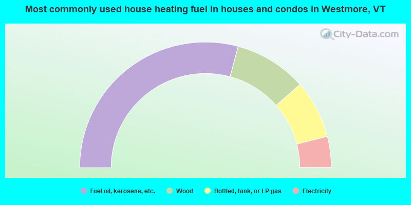
- 58.4%Fuel oil, kerosene, etc.
- 18.6%Wood
- 15.0%Bottled, tank, or LP gas
- 8.0%Electricity
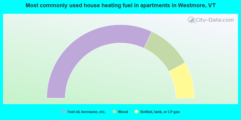
- 64.0%Fuel oil, kerosene, etc.
- 20.0%Wood
- 16.0%Bottled, tank, or LP gas
Westmore compared to Vermont state average:
- Unemployed percentage significantly below state average.
- Black race population percentage significantly below state average.
- Hispanic race population percentage significantly below state average.
- Median age above state average.
- Foreign-born population percentage significantly below state average.
- Renting percentage significantly below state average.
- Length of stay since moving in significantly above state average.
- Number of rooms per house significantly below state average.
- House age significantly below state average.
- Number of college students below state average.