De Witt, Iowa

Submit your own pictures of this city and show them to the world
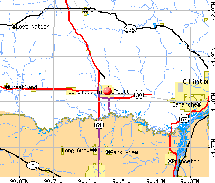
- OSM Map
- General Map
- Google Map
- MSN Map
Population change since 2000: +9.5%
 |
| Males: 2,484 | |
| Females: 3,047 |
| Median resident age: | 37.5 years |
| Iowa median age: | 38.9 years |
Zip codes: 52742.
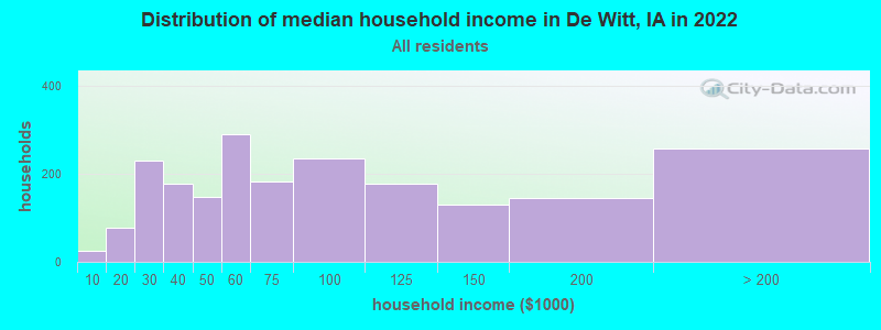
| De Witt: | $65,725 |
| IA: | $69,588 |
Estimated per capita income in 2022: $40,537 (it was $19,717 in 2000)
De Witt city income, earnings, and wages data
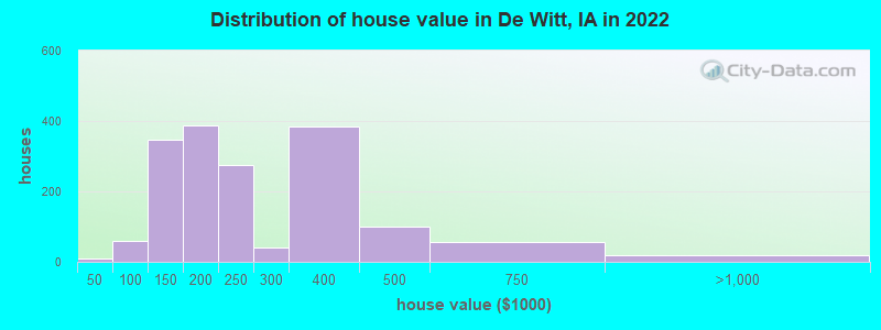
Estimated median house or condo value in 2022: $208,959 (it was $91,200 in 2000)
| De Witt: | $208,959 |
| IA: | $194,600 |
Mean prices in 2022: all housing units: $233,045; detached houses: $228,087; townhouses or other attached units: $361,457
Median gross rent in 2022: $871.
(8.2% for White Non-Hispanic residents, 4.0% for Black residents)
Detailed information about poverty and poor residents in De Witt, IA


Compare current foreclosures near De Witt, IA:
| Photo | Address | Area | Beds / Baths | Price | Details |
|---|---|---|---|---|---|

|
#1
3rd Ave
De Witt, IA 52742
|
- sq. feet
|
2 baths 4 beds |
show details | |

|
#2
260th Ave, Trlr 53
De Witt, IA 52742
|
- sq. feet
|
- baths - beds |
show details | |

|
#3
E 8th St
De Witt, IA 52742
|
- sq. feet
|
- baths - beds |
show details | |

|
#4
S Main St
Albany, IL 61230
|
1,564 sq. feet
|
1 baths 3 beds |
$133,000
|
show details |

|
#5
8th Ave
De Witt, IA 52742
|
- sq. feet
|
- baths - beds |
show details | |

|
#6
1st St
De Witt, IA 52742
|
- sq. feet
|
- baths - beds |
show details | |

|
#7
E Jefferson St
Wheatland, IA 52777
|
- sq. feet
|
1 baths 3 beds |
show details | |

|
#8
3rd St S
Cordova, IL 61242
|
1,576 sq. feet
|
2 baths 5 beds |
show details | |

|
#9
Park Ave S
Eldridge, IA 52748
|
1,200 sq. feet
|
3 baths 4 beds |
show details | |

|
#10
Park Ave S
Eldridge, IA 52748
|
2,400 sq. feet
|
2 baths 4 beds |
show details |
| Photo | Address | Area | Beds / Baths | Price | Details |
|---|---|---|---|---|---|

|
#11
Welton Ave
Welton, IA 52774
|
1,340 sq. feet
|
1 baths 3 beds |
show details | |

|
#12
Park Ave S
Eldridge, IA 52748
|
1,026 sq. feet
|
1 baths 3 beds |
show details | |

|
#13
E 1st Ave
Donahue, IA 52746
|
1,680 sq. feet
|
1 baths 4 beds |
show details | |

|
#14
N 8th St
Eldridge, IA 52748
|
972 sq. feet
|
2 baths 4 beds |
show details | |

|
#15
S 18th St
Clinton, IA 52732
|
- sq. feet
|
1 baths 2 beds |
show details | |

|
#16
E Vine St
Wheatland, IA 52777
|
- sq. feet
|
- baths - beds |
show details | |

|
#17
Friendship Trl, Apt 2005
Clinton, IA 52732
|
- sq. feet
|
- baths - beds |
show details | |

|
#18
2nd St
Camanche, IA 52730
|
- sq. feet
|
- baths - beds |
show details | |

|
#19
3rd Ave S
Albany, IL 61230
|
- sq. feet
|
- baths - beds |
show details | |

|
#20
Lincoln Way # 1
Clinton, IA 52732
|
- sq. feet
|
- baths - beds |
show details |
| Photo | Address | Area | Beds / Baths | Price | Details |
|---|---|---|---|---|---|

|
#21
Eastern Ave Apt G3
Davenport, IA 52807
|
- sq. feet
|
- baths - beds |
show details | |

|
#22
Hurst St
Delmar, IA 52037
|
- sq. feet
|
- baths - beds |
show details | |

|
#23
W Spring St
Eldridge, IA 52748
|
- sq. feet
|
- baths - beds |
show details | |

|
#24
N 7th St
Eldridge, IA 52748
|
- sq. feet
|
- baths - beds |
show details | |

|
#25
W Price St
Eldridge, IA 52748
|
- sq. feet
|
- baths - beds |
show details | |

|
#26
W 61st St
Davenport, IA 52806
|
- sq. feet
|
- baths - beds |
show details | |

|
#27
Caroline Ave
Clinton, IA 52732
|
- sq. feet
|
- baths - beds |
show details | |

|
#28
21st Place Ct
Clinton, IA 52732
|
- sq. feet
|
- baths - beds |
show details | |

|
#29
N Church St
Albany, IL 61230
|
- sq. feet
|
- baths - beds |
show details | |

|
#30
Willany Dr
Clinton, IA 52732
|
- sq. feet
|
- baths - beds |
show details |
| Photo | Address | Area | Beds / Baths | Price | Details |
|---|---|---|---|---|---|

|
#31
Ruth Pl
Clinton, IA 52732
|
- sq. feet
|
- baths - beds |
show details | |

|
#32
6th St
Camanche, IA 52730
|
- sq. feet
|
- baths - beds |
show details | |

|
#33
Belle Ave
Davenport, IA 52807
|
- sq. feet
|
- baths - beds |
show details | |

|
#34
Bunker Hill Rd
Albany, IL 61230
|
- sq. feet
|
- baths - beds |
show details | |

|
#35
W 66th St
Davenport, IA 52806
|
- sq. feet
|
- baths - beds |
show details | |

|
#36
N Ripley St
Davenport, IA 52806
|
- sq. feet
|
- baths - beds |
show details | |

|
#37
4th St
Camanche, IA 52730
|
- sq. feet
|
- baths - beds |
show details | |

|
#38
170th St
Goose Lake, IA 52750
|
- sq. feet
|
- baths - beds |
show details | |

|
#39
Center Ct
Clinton, IA 52732
|
- sq. feet
|
- baths - beds |
show details | |

|
Check over 1 million property listings on Foreclosure.com!
|
browse all offers | |||

- 5,03691.1%White alone
- 2454.4%Asian alone
- 1142.1%Hispanic
- 500.9%Black alone
- 140.3%Two or more races
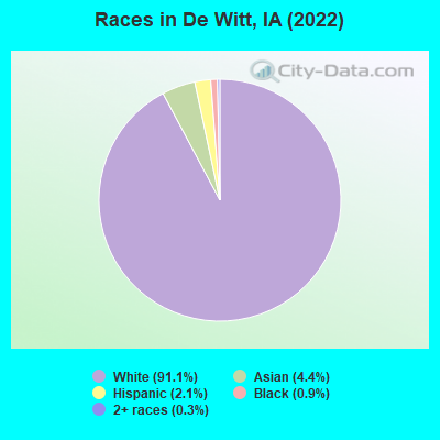
Races in De Witt detailed stats: ancestries, foreign born residents, place of birth
According to our research of Iowa and other state lists, there were 2 registered sex offenders living in De Witt, Iowa as of May 18, 2024.
The ratio of all residents to sex offenders in De Witt is 2,656 to 1.
The ratio of registered sex offenders to all residents in this city is much lower than the state average.
Type |
2009 |
2010 |
2011 |
2012 |
2013 |
2014 |
2015 |
2016 |
2017 |
2018 |
2019 |
2020 |
2021 |
2022 |
|---|---|---|---|---|---|---|---|---|---|---|---|---|---|---|
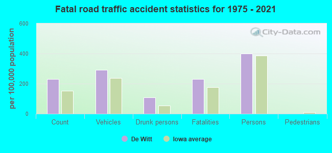
| Murders (per 100,000) | 0 (0.0) | 0 (0.0) | 0 (0.0) | 0 (0.0) | 0 (0.0) | 0 (0.0) | 0 (0.0) | 0 (0.0) | 0 (0.0) | 0 (0.0) | 0 (0.0) | 0 (0.0) | 0 (0.0) | 0 (0.0) |
| Rapes (per 100,000) | 0 (0.0) | 1 (18.8) | 3 (56.1) | 2 (37.5) | 0 (0.0) | 1 (19.0) | 0 (0.0) | 1 (19.1) | 1 (19.2) | 2 (38.4) | 3 (58.2) | 2 (38.6) | 3 (57.6) | 2 (36.2) |
| Robberies (per 100,000) | 0 (0.0) | 0 (0.0) | 0 (0.0) | 0 (0.0) | 0 (0.0) | 0 (0.0) | 0 (0.0) | 0 (0.0) | 2 (38.3) | 0 (0.0) | 0 (0.0) | 1 (19.3) | 1 (19.2) | 0 (0.0) |
| Assaults (per 100,000) | 9 (170.3) | 7 (131.5) | 9 (168.2) | 12 (225.1) | 8 (151.7) | 9 (170.6) | 7 (133.7) | 6 (114.8) | 15 (287.5) | 13 (249.8) | 5 (97.0) | 2 (38.6) | 16 (307.0) | 36 (651.2) |
| Burglaries (per 100,000) | 32 (605.4) | 21 (394.6) | 32 (598.1) | 13 (243.9) | 35 (663.8) | 32 (606.6) | 25 (477.5) | 35 (669.7) | 23 (440.8) | 9 (172.9) | 24 (465.7) | 17 (328.3) | 21 (402.9) | 16 (289.4) |
| Thefts (per 100,000) | 49 (927.0) | 57 (1,071) | 55 (1,028) | 45 (844.1) | 42 (796.5) | 39 (739.3) | 41 (783.0) | 44 (841.9) | 57 (1,092) | 60 (1,153) | 65 (1,261) | 55 (1,062) | 48 (921.0) | 81 (1,465) |
| Auto thefts (per 100,000) | 5 (94.6) | 6 (112.7) | 1 (18.7) | 3 (56.3) | 3 (56.9) | 4 (75.8) | 2 (38.2) | 3 (57.4) | 2 (38.3) | 1 (19.2) | 15 (291.1) | 7 (135.2) | 4 (76.7) | 10 (180.9) |
| Arson (per 100,000) | 1 (18.9) | 0 (0.0) | 0 (0.0) | 4 (75.0) | 0 (0.0) | 0 (0.0) | 0 (0.0) | 0 (0.0) | 0 (0.0) | 0 (0.0) | 1 (19.4) | 0 (0.0) | 0 (0.0) | 0 (0.0) |
| City-Data.com crime index | 121.1 | 120.8 | 163.0 | 130.4 | 113.2 | 127.4 | 94.5 | 123.4 | 161.9 | 140.5 | 172.3 | 120.7 | 184.4 | 252.5 |
The City-Data.com crime index weighs serious crimes and violent crimes more heavily. Higher means more crime, U.S. average is 246.1. It adjusts for the number of visitors and daily workers commuting into cities.
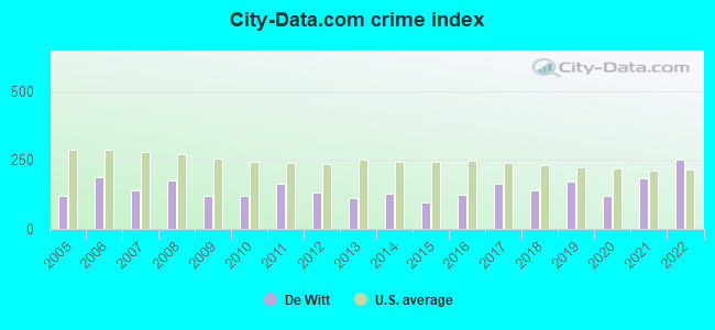
Crime rate in De Witt detailed stats: murders, rapes, robberies, assaults, burglaries, thefts, arson
Full-time law enforcement employees in 2021, including police officers: 10 (9 officers - 8 male; 1 female).
| Officers per 1,000 residents here: | 1.73 |
| Iowa average: | 1.76 |
 Recent articles from our blog. Our writers, many of them Ph.D. graduates or candidates, create easy-to-read articles on a wide variety of topics.

 | clinton,ia (3 replies) |
Latest news from De Witt, IA collected exclusively by city-data.com from local newspapers, TV, and radio stations
Ancestries: German (49.4%), Irish (13.0%), American (9.6%), English (7.3%), Norwegian (1.6%), Swedish (1.3%).
Current Local Time: CST time zone
Incorporated on 09/20 1858
Elevation: 700 feet
Land area: 4.87 square miles.
Population density: 1,136 people per square mile (low).
254 residents are foreign born (4.2% Asia).
| This city: | 4.6% |
| Iowa: | 5.6% |
Median real estate property taxes paid for housing units with mortgages in 2022: $2,871 (1.6%)
Median real estate property taxes paid for housing units with no mortgage in 2022: $3,979 (1.7%)
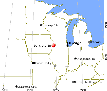
Nearest city with pop. 50,000+: Davenport, IA  (19.5 miles , pop. 98,359).
Nearest city with pop. 200,000+: Madison, WI (104.5 miles , pop. 208,054).
Nearest city with pop. 1,000,000+: Chicago, IL (147.6 miles , pop. 2,896,016).
Nearest cities:
), ), ), ), ), ), )Latitude: 41.82 N, Longitude: 90.54 W
Daytime population change due to commuting: +535 (+9.7%)
Workers who live and work in this city: 984 (37.9%)
Area code: 563

De Witt, Iowa accommodation & food services, waste management - Economy and Business Data
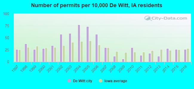
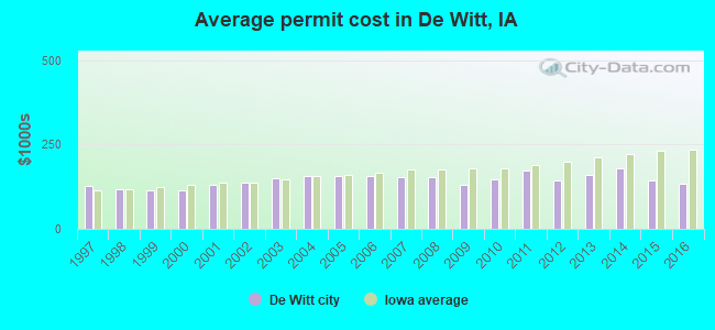
Single-family new house construction building permits:
- 2016: 13 buildings, average cost: $133,100
- 2015: 13 buildings, average cost: $144,900
- 2014: 14 buildings, average cost: $181,100
- 2013: 6 buildings, average cost: $161,300
- 2012: 9 buildings, average cost: $143,200
- 2011: 7 buildings, average cost: $171,900
- 2010: 15 buildings, average cost: $148,100
- 2009: 3 buildings, average cost: $129,000
- 2008: 6 buildings, average cost: $153,300
- 2007: 15 buildings, average cost: $152,500
- 2006: 29 buildings, average cost: $156,900
- 2005: 37 buildings, average cost: $156,800
- 2004: 39 buildings, average cost: $157,200
- 2003: 30 buildings, average cost: $150,600
- 2002: 29 buildings, average cost: $138,000
- 2001: 17 buildings, average cost: $131,300
- 2000: 14 buildings, average cost: $113,900
- 1999: 13 buildings, average cost: $114,300
- 1998: 19 buildings, average cost: $118,200
- 1997: 13 buildings, average cost: $127,000
| Here: | 3.6% |
| Iowa: | 2.7% |
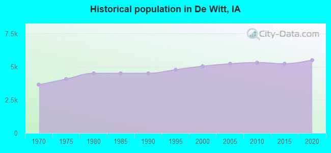
Population change in the 1990s: +419 (+9.0%).
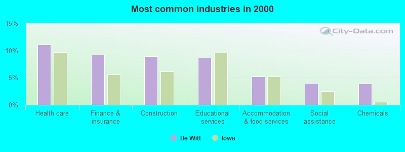
- Health care (11.1%)
- Finance & insurance (9.2%)
- Construction (9.0%)
- Educational services (8.7%)
- Accommodation & food services (5.3%)
- Social assistance (4.0%)
- Chemicals (3.9%)
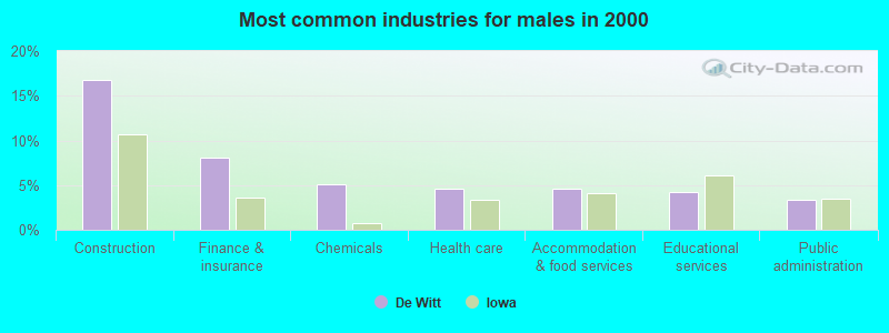
- Construction (16.7%)
- Finance & insurance (8.0%)
- Chemicals (5.1%)
- Health care (4.6%)
- Accommodation & food services (4.6%)
- Educational services (4.2%)
- Public administration (3.3%)
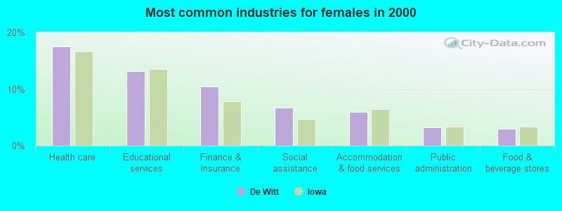
- Health care (17.5%)
- Educational services (13.1%)
- Finance & insurance (10.4%)
- Social assistance (6.7%)
- Accommodation & food services (6.0%)
- Public administration (3.3%)
- Food & beverage stores (3.0%)
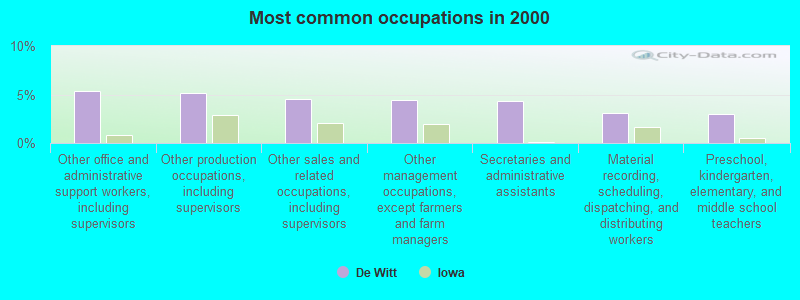
- Other office and administrative support workers, including supervisors (5.4%)
- Other production occupations, including supervisors (5.2%)
- Other sales and related occupations, including supervisors (4.6%)
- Other management occupations, except farmers and farm managers (4.4%)
- Secretaries and administrative assistants (4.4%)
- Material recording, scheduling, dispatching, and distributing workers (3.1%)
- Preschool, kindergarten, elementary, and middle school teachers (3.0%)
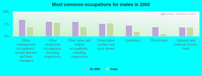
- Other management occupations, except farmers and farm managers (6.8%)
- Other production occupations, including supervisors (5.9%)
- Other sales and related occupations, including supervisors (5.9%)
- Driver/sales workers and truck drivers (5.2%)
- Carpenters (4.5%)
- Electricians (3.9%)
- Laborers and material movers, hand (3.7%)
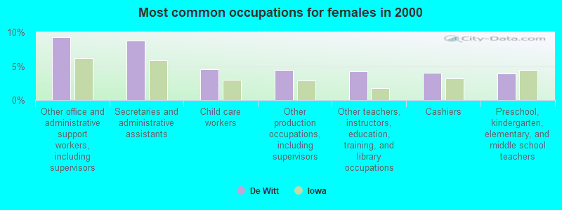
- Other office and administrative support workers, including supervisors (9.2%)
- Secretaries and administrative assistants (8.8%)
- Child care workers (4.6%)
- Other production occupations, including supervisors (4.4%)
- Other teachers, instructors, education, training, and library occupations (4.2%)
- Cashiers (4.0%)
- Preschool, kindergarten, elementary, and middle school teachers (4.0%)
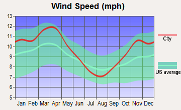
Average climate in De Witt, Iowa
Based on data reported by over 4,000 weather stations


|
|

(lower is better)
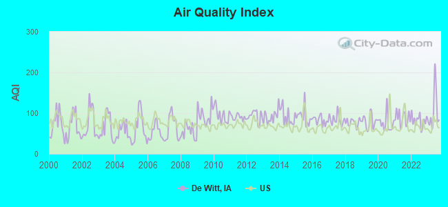
Air Quality Index (AQI) level in 2023 was 104. This is significantly worse than average.
| City: | 104 |
| U.S.: | 73 |
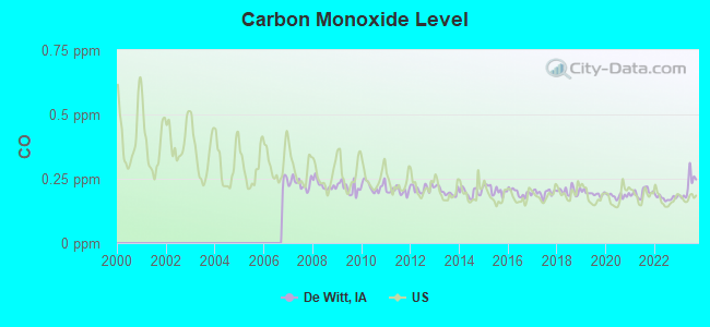
Carbon Monoxide (CO) [ppm] level in 2023 was 0.220. This is about average. Closest monitor was 18.5 miles away from the city center.
| City: | 0.220 |
| U.S.: | 0.251 |
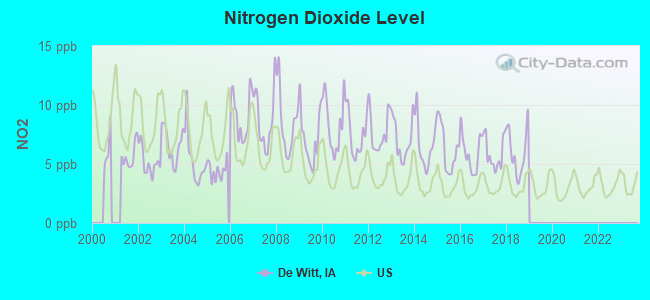
Nitrogen Dioxide (NO2) [ppb] level in 2018 was 6.00. This is about average. Closest monitor was 8.6 miles away from the city center.
| City: | 6.00 |
| U.S.: | 5.11 |
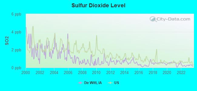
Sulfur Dioxide (SO2) [ppb] level in 2023 was 0.251. This is significantly better than average. Closest monitor was 8.6 miles away from the city center.
| City: | 0.251 |
| U.S.: | 1.515 |
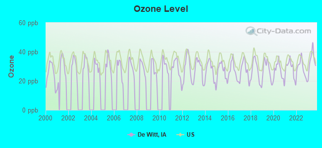
Ozone [ppb] level in 2023 was 33.8. This is about average. Closest monitor was 11.6 miles away from the city center.
| City: | 33.8 |
| U.S.: | 33.3 |

Particulate Matter (PM10) [µg/m3] level in 2005 was 21.7. This is about average. Closest monitor was 17.0 miles away from the city center.
| City: | 21.7 |
| U.S.: | 19.2 |
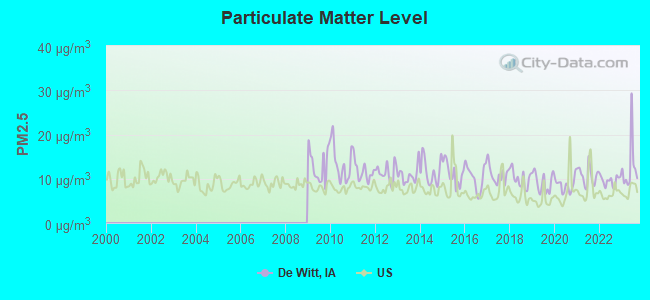
Particulate Matter (PM2.5) [µg/m3] level in 2023 was 12.6. This is significantly worse than average. Closest monitor was 17.0 miles away from the city center.
| City: | 12.6 |
| U.S.: | 8.1 |
Tornado activity:
De Witt-area historical tornado activity is near Iowa state average. It is 76% greater than the overall U.S. average.
On 4/11/1965, a category F4 (max. wind speeds 207-260 mph) tornado 20.1 miles away from the De Witt city center killed one person and injured 3 people and caused between $500,000 and $5,000,000 in damages.
On 3/29/1981, a category F4 tornado 32.1 miles away from the city center caused between $500,000 and $5,000,000 in damages.
Earthquake activity:
De Witt-area historical earthquake activity is significantly above Iowa state average. It is 111% greater than the overall U.S. average.On 4/18/2008 at 09:36:59, a magnitude 5.4 (5.1 MB, 4.8 MS, 5.4 MW, 5.2 MW, Class: Moderate, Intensity: VI - VII) earthquake occurred 272.2 miles away from the city center
On 6/10/1987 at 23:48:54, a magnitude 5.1 (4.9 MB, 4.4 MS, 4.6 MS, 5.1 LG) earthquake occurred 250.5 miles away from De Witt center
On 4/18/2008 at 09:36:59, a magnitude 5.2 (5.2 MW, Depth: 8.9 mi) earthquake occurred 272.2 miles away from the city center
On 6/28/2004 at 06:10:52, a magnitude 4.2 (4.2 MW, Depth: 6.2 mi, Class: Light, Intensity: IV - V) earthquake occurred 88.5 miles away from the city center
On 6/18/2002 at 17:37:15, a magnitude 5.0 (4.3 MB, 4.6 MW, 5.0 LG) earthquake occurred 303.1 miles away from De Witt center
On 4/18/2008 at 15:14:16, a magnitude 4.8 (4.5 MB, 4.8 MW, 4.6 MW) earthquake occurred 271.8 miles away from the city center
Magnitude types: regional Lg-wave magnitude (LG), body-wave magnitude (MB), surface-wave magnitude (MS), moment magnitude (MW)
Natural disasters:
The number of natural disasters in Clinton County (21) is greater than the US average (15).Major Disasters (Presidential) Declared: 18
Emergencies Declared: 1
Causes of natural disasters: Floods: 16, Storms: 13, Tornadoes: 4, Winter Storms: 2, Heavy Rain: 1, Hurricane: 1, Wind: 1, Other: 1 (Note: some incidents may be assigned to more than one category).
Hospitals and medical centers in De Witt:
Operable nuclear power plants near De Witt:
- 16 miles: Quad Cities 1 and 2 in Cordova, IL.
Colleges/universities with over 2000 students nearest to De Witt:
- Ashford University (about 18 miles; Clinton, IA; Full-time enrollment: 73,330)
- Kaplan University-Davenport Campus (about 19 miles; Davenport, IA; FT enrollment: 60,376)
- Saint Ambrose University (about 20 miles; Davenport, IA; FT enrollment: 3,053)
- Eastern Iowa Community College District (about 21 miles; Davenport, IA; FT enrollment: 5,507)
- Augustana College (about 23 miles; Rock Island, IL; FT enrollment: 2,555)
- Black Hawk College (about 25 miles; Moline, IL; FT enrollment: 5,086)
- University of Iowa (about 53 miles; Iowa City, IA; FT enrollment: 24,735)
Public high school in De Witt:
- CENTRAL HIGH SCHOOL (Students: 607, Location: 519 E. 11TH ST., Grades: 9-12)
Public elementary/middle schools in De Witt:
- EKSTRAND ELEMENTARY SCHOOL (Students: 626, Location: 1140 15TH ST, Grades: PK-3)
- CENTRAL MIDDLE SCHOOL (Students: 335, Location: 425 E. 11TH ST., Grades: 7-8)
Private elementary/middle school in De Witt:
Points of interest:
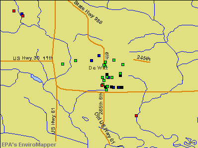
Notable locations in De Witt: De Witt (A), 4-H Fairgrounds (B), Dewitt Ambulance Service (C), Guardian Glass Industries Emergency Medical Services (D), Frances Banta Waggoner Library (E), De Witt Police Department (F), De Witt Volunteer Fire Department (G). Display/hide their locations on the map
Churches in De Witt include: First Congregational United Church (A), De Witt Lutheran Fellowship (B), De Witt Evangelical Free Church (C), First Baptist Church (D), Jehovahs Witnesses Congregation (E), Living Word Bible Church (F), Grace Lutheran Church (G), United Methodist Church (H), Saint Joseph Church (I). Display/hide their locations on the map
Cemeteries: Saint Joseph Cemetery (1), Elmwood Cemetery (2). Display/hide their locations on the map
Parks in De Witt include: John Letter Historical Marker (1), Lincoln Park (2), West Brook Park (3). Display/hide their locations on the map
Tourist attractions: Central Community Historical Society (Museums; 2503 340th Avenue), Clinton County Club Show (Amusement & Theme Parks; 328 East 8th Street).
Hotels: Super 8 Motel (918 Westwood Drive), Winsther Motel (924 11th Street), Westwind Motel (1221 11th Street).
| This city: | 2.4 people |
| Iowa: | 2.4 people |
| This city: | 64.1% |
| Whole state: | 64.7% |
| This city: | 5.1% |
| Whole state: | 6.7% |
Likely homosexual households (counted as self-reported same-sex unmarried-partner households)
- Lesbian couples: 0.2% of all households
- Gay men: 0.0% of all households
People in group quarters in De Witt in 2010:
- 54 people in nursing facilities/skilled-nursing facilities
- 34 people in group homes intended for adults
- 7 people in in-patient hospice facilities
- 2 people in residential treatment centers for adults
4 people in homes for the mentally ill in 2000
Banks with branches in De Witt (2011 data):
- De Witt Bank & Trust Co.: at 815 Sixth Avenue, branch established on 1933/06/15. Info updated 2006/11/03: Bank assets: $118.1 mil, Deposits: $103.2 mil, local headquarters, positive income, Agricultural Specialization, 1 total offices, Holding Company: De Witt Bancorp, Inc.
- First Central State Bank: at 914 Sixth Avenue, branch established on 1967/06/12. Info updated 2006/11/03: Bank assets: $268.7 mil, Deposits: $207.2 mil, local headquarters, positive income, Agricultural Specialization, 4 total offices, Holding Company: Ohnward Bancshares, Inc.
- U.S. Bank National Association: Dewitt 11th Street at 712 11th Street, branch established on 1918/01/01. Info updated 2012/01/30: Bank assets: $330,470.8 mil, Deposits: $236,091.5 mil, headquarters in Cincinnati, OH, positive income, 3121 total offices, Holding Company: U.S. Bancorp
For population 15 years and over in De Witt:
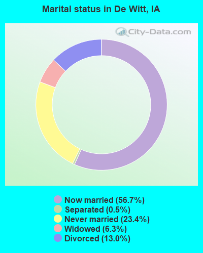
- Never married: 23.4%
- Now married: 56.7%
- Separated: 0.5%
- Widowed: 6.3%
- Divorced: 13.0%
For population 25 years and over in De Witt:
- High school or higher: 95.6%
- Bachelor's degree or higher: 40.1%
- Graduate or professional degree: 13.6%
- Unemployed: 2.4%
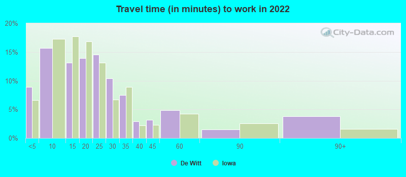
- Mean travel time to work (commute): 20.4 minutes

| Here: | 10.7 |
| Iowa average: | 10.5 |
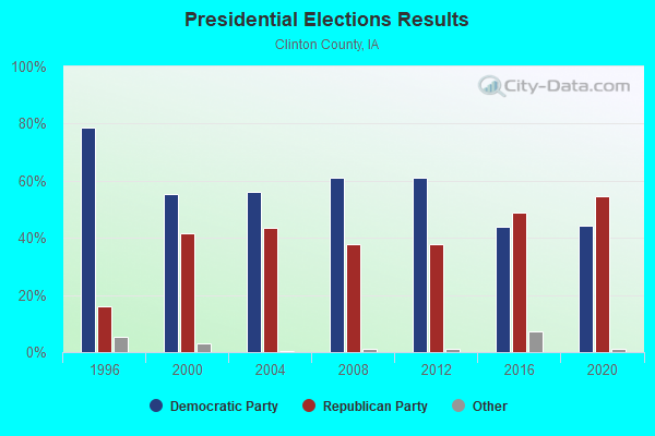
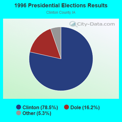
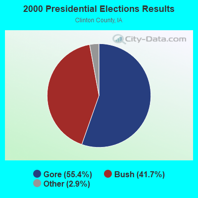
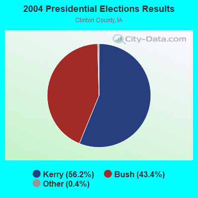
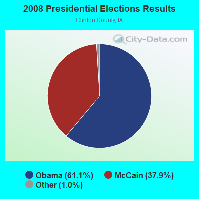
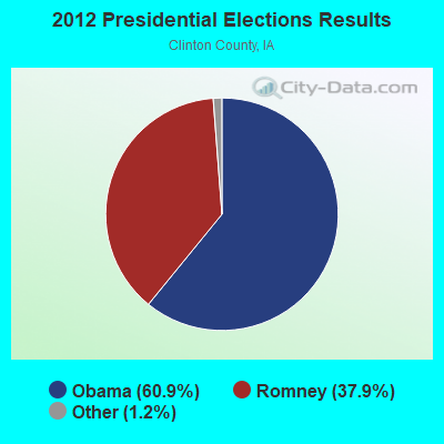

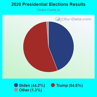
Graphs represent county-level data. Detailed 2008 Election Results
Religion statistics for De Witt, IA (based on Clinton County data)
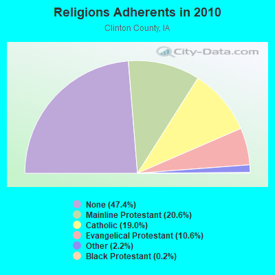
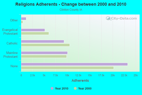
| Religion | Adherents | Congregations |
|---|---|---|
| Mainline Protestant | 10,135 | 33 |
| Catholic | 9,340 | 11 |
| Evangelical Protestant | 5,187 | 24 |
| Other | 1,061 | 10 |
| Black Protestant | 122 | 1 |
| None | 23,271 | - |
Food Environment Statistics:
| This county: | 1.83 / 10,000 pop. |
| Iowa: | 2.14 / 10,000 pop. |
| Clinton County: | 0.20 / 10,000 pop. |
| Iowa: | 0.23 / 10,000 pop. |
| Here: | 0.41 / 10,000 pop. |
| Iowa: | 0.43 / 10,000 pop. |
| This county: | 5.71 / 10,000 pop. |
| Iowa: | 5.55 / 10,000 pop. |
| Clinton County: | 7.13 / 10,000 pop. |
| Iowa: | 8.01 / 10,000 pop. |
| Clinton County: | 9.2% |
| Iowa: | 7.8% |
| Clinton County: | 27.9% |
| Iowa: | 27.3% |
| Clinton County: | 14.6% |
| Iowa: | 14.5% |
Health and Nutrition:
| This city: | 51.1% |
| Iowa: | 49.5% |
| This city: | 49.1% |
| State: | 46.1% |
| This city: | 28.6 |
| Iowa: | 28.6 |
| De Witt: | 18.9% |
| Iowa: | 21.4% |
| De Witt: | 8.7% |
| Iowa: | 10.4% |
| This city: | 6.8 |
| Iowa: | 6.8 |
| De Witt: | 35.5% |
| Iowa: | 33.8% |
| De Witt: | 57.7% |
| Iowa: | 55.9% |
| This city: | 78.4% |
| Iowa: | 77.7% |
More about Health and Nutrition of De Witt, IA Residents
| Local government employment and payroll (March 2022) | |||||
| Function | Full-time employees | Monthly full-time payroll | Average yearly full-time wage | Part-time employees | Monthly part-time payroll |
|---|---|---|---|---|---|
| Police Protection - Officers | 10 | $59,103 | $70,924 | 0 | $0 |
| Streets and Highways | 4 | $19,218 | $57,654 | 2 | $948 |
| Parks and Recreation | 3 | $12,056 | $48,224 | 33 | $10,921 |
| Financial Administration | 3 | $13,331 | $53,324 | 0 | $0 |
| Water Supply | 3 | $14,902 | $59,608 | 0 | $0 |
| Other Government Administration | 3 | $18,762 | $75,048 | 2 | $407 |
| Sewerage | 2 | $10,087 | $60,522 | 1 | $1,964 |
| Local Libraries | 1 | $5,333 | $63,996 | 7 | $10,032 |
| Other and Unallocable | 1 | $6,534 | $78,408 | 0 | $0 |
| Police - Other | 1 | $3,066 | $36,792 | 2 | $1,370 |
| Fire - Other | 0 | $0 | 3 | $1,513 | |
| Totals for Government | 31 | $162,392 | $62,861 | 50 | $27,154 |
De Witt government finances - Expenditure in 2017 (per resident):
- Construction - Regular Highways: $1,708,000 ($308.80)
Housing and Community Development: $226,000 ($40.86)
Parks and Recreation: $103,000 ($18.62)
- Current Operations - Police Protection: $1,182,000 ($213.70)
Parks and Recreation: $867,000 ($156.75)
Sewerage: $808,000 ($146.09)
Water Utilities: $658,000 ($118.97)
Regular Highways: $637,000 ($115.17)
General - Other: $449,000 ($81.18)
Solid Waste Management: $394,000 ($71.23)
Libraries: $314,000 ($56.77)
Central Staff Services: $157,000 ($28.39)
Financial Administration: $137,000 ($24.77)
Housing and Community Development: $116,000 ($20.97)
Protective Inspection and Regulation - Other: $77,000 ($13.92)
Local Fire Protection: $75,000 ($13.56)
Miscellaneous Commercial Activities - Other: $66,000 ($11.93)
General Public Buildings: $32,000 ($5.79)
Health - Other: $26,000 ($4.70)
Judicial and Legal Services: $21,000 ($3.80)
Public Welfare - Other: $12,000 ($2.17)
- General - Interest on Debt: $385,000 ($69.61)
- Intergovernmental to Local - Other - Solid Waste Management: $43,000 ($7.77)
- Other Capital Outlay - Police Protection: $53,000 ($9.58)
Regular Highways: $33,000 ($5.97)
Sewerage: $24,000 ($4.34)
Parks and Recreation: $14,000 ($2.53)
Local Fire Protection: $9,000 ($1.63)
Water Utilities: $7,000 ($1.27)
General Public Building: $3,000 ($0.54)
Libraries: $3,000 ($0.54)
Central Staff Services: $1,000 ($0.18)
- Total Salaries and Wages: $2,461,000 ($444.95)
- Water Utilities - Interest on Debt: $8,000 ($1.45)
De Witt government finances - Revenue in 2017 (per resident):
- Charges - Sewerage: $1,062,000 ($192.01)
Solid Waste Management: $387,000 ($69.97)
Other: $277,000 ($50.08)
Parks and Recreation: $215,000 ($38.87)
Miscellaneous Commercial Activities: $19,000 ($3.44)
- Federal Intergovernmental - Housing and Community Development: $174,000 ($31.46)
Other: $13,000 ($2.35)
- Local Intergovernmental - Housing and Community Development: $55,000 ($9.94)
Other: $45,000 ($8.14)
- Miscellaneous - General Revenue - Other: $193,000 ($34.89)
Rents: $70,000 ($12.66)
Interest Earnings: $60,000 ($10.85)
Sale of Property: $53,000 ($9.58)
Fines and Forfeits: $17,000 ($3.07)
- Revenue - Water Utilities: $655,000 ($118.42)
- State Intergovernmental - Highways: $661,000 ($119.51)
General Local Government Support: $113,000 ($20.43)
Other: $5,000 ($0.90)
- Tax - Property: $4,461,000 ($806.54)
General Sales and Gross Receipts: $636,000 ($114.99)
Other License: $139,000 ($25.13)
Public Utilities Sales: $56,000 ($10.12)
Other Selective Sales: $29,000 ($5.24)
De Witt government finances - Debt in 2017 (per resident):
- Long Term Debt - Beginning Outstanding - Unspecified Public Purpose: $19,217,000 ($3474.42)
Outstanding Unspecified Public Purpose: $17,257,000 ($3120.05)
Retired Unspecified Public Purpose: $1,960,000 ($354.37)
De Witt government finances - Cash and Securities in 2017 (per resident):
- Bond Funds - Cash and Securities: $1,336,000 ($241.55)
- Other Funds - Cash and Securities: $8,365,000 ($1512.38)
- Sinking Funds - Cash and Securities: $7,000 ($1.27)
| Businesses in De Witt, IA | ||||
| Name | Count | Name | Count | |
|---|---|---|---|---|
| Chevrolet | 1 | Super 8 | 1 | |
| La-Z-Boy | 1 | True Value | 1 | |
| Pizza Hut | 1 | UPS | 1 | |
| Subway | 1 | |||
Strongest AM radio stations in De Witt:
- WOC (1420 AM; 5 kW; DAVENPORT, IA; Owner: CITICASTERS LICENSES, L.P.)
- WKBF (1270 AM; 5 kW; ROCK ISLAND, IL; Owner: MERCURY BROADCASTING COMPANY, INC.)
- WSCR (670 AM; 50 kW; CHICAGO, IL; Owner: INFINITY BROADCASTING OPERATIONS, INC.)
- WGN (720 AM; 50 kW; CHICAGO, IL; Owner: WGN CONTINENTAL BROADCASTING CO.)
- WTMJ (620 AM; 50 kW; MILWAUKEE, WI; Owner: JOURNAL BROADCAST CORPORATION)
- KXEL (1540 AM; 50 kW; WATERLOO, IA; Owner: KXEL BROADCASTING COMPANY, INC.)
- WBBM (780 AM; 50 kW; CHICAGO, IL; Owner: INFINITY BROADCASTING OPERATIONS, INC.)
- WMVP (1000 AM; 50 kW; CHICAGO, IL; Owner: ABC, INC.)
- WLS (890 AM; 50 kW; CHICAGO, IL; Owner: WLS, INC.)
- WMT (600 AM; 5 kW; CEDAR RAPIDS, IA; Owner: CITICASTERS LICENSES, L.P.)
- WYLL (1160 AM; 50 kW; CHICAGO, IL; Owner: SCA LICENSE CORPORATION)
- KROS (1340 AM; 1 kW; CLINTON, IA; Owner: KROS BROADCASTING, INC.)
- KCLN (1390 AM; 1 kW; CLINTON, IA; Owner: WPW BROADCASTING, INC)
Strongest FM radio stations in De Witt:
- KBOB-FM (104.9 FM; GENESEO, IL; Owner: CUMULUS LICENSING CORP.)
- KCQQ (106.5 FM; DAVENPORT, IA; Owner: CITICASTERS LICENSES, L.P.)
- KMXG (96.1 FM; CLINTON, IA; Owner: CITICASTERS LICENSES, L.P.)
- WLLR-FM (103.7 FM; DAVENPORT, IA; Owner: CITICASTERS LICENSES, L.P.)
- WVIK (90.3 FM; ROCK ISLAND, IL; Owner: AUGUSTANA COLLEGE)
- KUUL (101.3 FM; EAST MOLINE, IL; Owner: CITICASTERS LICENSES, L.P.)
- WDLM-FM (89.3 FM; EAST MOLINE, IL; Owner: THE MOODY BIBLE INSTITUTE OF CHICAGO)
- KSUI (91.7 FM; IOWA CITY, IA; Owner: THE UNIVERSITY OF IOWA)
- WHTS (98.9 FM; ROCK ISLAND, IL; Owner: MERCURY BROADCASTING COMPANY, INC.)
- KORB (93.5 FM; BETTENDORF, IA; Owner: CUMULUS LICENSING CORP.)
- KZEG (94.7 FM; CLINTON, IA; Owner: WPW BROADCASTING, INC.)
- KBEA-FM (99.7 FM; MUSCATINE, IA; Owner: CUMULUS LICENSING CORP.)
- KMAQ-FM (95.1 FM; MAQUOKETA, IA; Owner: MAQUOKETA BROADCASTING COMPANY)
- WCCI (100.3 FM; SAVANNA, IL; Owner: CARROLL COUNTY COMMUNICATIONS, INC.)
TV broadcast stations around De Witt:
- WHBF-TV (Channel 4; ROCK ISLAND, IL; Owner: CORONET COMMUNICATIONS COMPANY)
- WBQD-LP (Channel 26; DAVENPORT, IA; Owner: FOUR SEASONS PEORIA, LLC)
- KWQC-TV (Channel 6; DAVENPORT, IA; Owner: YOUNG BROADCASTING OF DAVENPORT, INC.)
- K61HD (Channel 61; DAVENPORT, IA; Owner: TRINITY BROADCASTING NETWORK)
- KIIN (Channel 12; IOWA CITY, IA; Owner: IOWA PUBLIC BROADCASTING BOARD)
- KWKB (Channel 20; IOWA CITY, IA; Owner: KM TELEVISION OF IOWA, L.L.C.)
- K16EL (Channel 66; DAVENPORT, IA; Owner: THREE ANGELS BROADCASTING NETWORK)
- KLJB-TV (Channel 18; DAVENPORT, IA; Owner: QUAD CITIES TELEVISION ACQUISITION CORP.)
- WQAD-TV (Channel 8; MOLINE, IL; Owner: NEW YORK TIMES MANAGEMENT SERVICES)
- WQPT-TV (Channel 24; MOLINE, IL; Owner: BLACK HAWK COLLEGE)
- KQIN (Channel 36; DAVENPORT, IA; Owner: IOWA PUBLIC BROADCASTING BOARD)
- National Bridge Inventory (NBI) Statistics
- 36Number of bridges
- 630ft / 192mTotal length
- 113,485Total average daily traffic
- 17,392Total average daily truck traffic
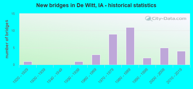
- New bridges - historical statistics
- 11920-1929
- 11950-1959
- 31960-1969
- 91970-1979
- 111980-1989
- 21990-1999
- 52000-2009
- 42010-2019
FCC Registered Antenna Towers:
21 (See the full list of FCC Registered Antenna Towers in De Witt)FCC Registered Broadcast Land Mobile Towers:
5- 711 10th St (Lat: 41.825028 Lon: -90.540972), Call Sign: KNGR875, Licensee ID: L00049835,
Assigned Frequencies: 154.235 MHz, 154.280 MHz, Grant Date: 04/21/1998, Expiration Date: 07/06/2003, Cancellation Date: 09/07/2003, Registrant: Dewitt, Town Of, 711 10th St, De Witt, IA 52742
- 801 Westwood Dr (Lat: 41.824472 Lon: -90.562361), Structure height: 36 m, Call Sign: KBG264,
Assigned Frequencies: 159.180 MHz, Grant Date: 09/04/2002, Expiration Date: 12/02/2012, Cancellation Date: 11/13/2012, Registrant: State Of, Dot Iowa, 800 Lincoln Way, Iowa, IA 50010, Phone: (515) 239-1552, Fax: (515) 232-6739, Email:
- BASE, 822 Sixth Ave (Lat: 41.823889 Lon: -90.538333), Type: Bant, Structure height: 7.6 m, Overall height: 9.1 m, Call Sign: WPGM322,
Assigned Frequencies: 153.920 MHz, Grant Date: 11/27/2014, Expiration Date: 02/13/2025, Registrant: Spectrum License Consultants Inc, Lubbock, TX 79453, Phone: (806) 780-7800, Fax: (806) 780-7802, Email:
- 8th Ave & 1st St (Lat: 41.819750 Lon: -90.534306), Call Sign: WDD867,
Assigned Frequencies: 469.025 MHz, Grant Date: 08/10/1999, Expiration Date: 08/15/2004, Cancellation Date: 06/10/2004, Registrant: C & J Service Co, 6th Ave S, De Witt, IA 52742, Phone: (319) 659-5145
- 2356 350th Ave. (Lat: 41.858056 Lon: -90.414167), Call Sign: WPWD942,
Assigned Frequencies: 157.605 MHz, Grant Date: 04/12/2013, Expiration Date: 10/24/2022, Cancellation Date: 12/24/2022, Certifier: Russell L Petersen, Registrant: Midwest Wireless LLC, 5915 Brady St, Davenport, IA 52806, Phone: (563) 386-7344, Fax: (563) 386-9011, Email:
FCC Registered Microwave Towers:
10 (See the full list of FCC Registered Microwave Towers in this town)FCC Registered Amateur Radio Licenses:
19 (See the full list of FCC Registered Amateur Radio Licenses in De Witt)FAA Registered Aircraft:
16 (See the full list of FAA Registered Aircraft in De Witt)| Most common first names in De Witt, IA among deceased individuals | ||
| Name | Count | Lived (average) |
|---|---|---|
| Mary | 49 | 81.7 years |
| John | 47 | 79.4 years |
| William | 47 | 77.7 years |
| Robert | 46 | 70.2 years |
| Helen | 38 | 81.1 years |
| Margaret | 34 | 81.8 years |
| Donald | 28 | 71.1 years |
| Raymond | 28 | 79.3 years |
| James | 27 | 72.8 years |
| George | 24 | 78.1 years |
| Most common last names in De Witt, IA among deceased individuals | ||
| Last name | Count | Lived (average) |
|---|---|---|
| Smith | 39 | 76.3 years |
| Anderson | 21 | 79.8 years |
| Peters | 15 | 80.2 years |
| Soenksen | 13 | 85.4 years |
| Cousins | 13 | 78.6 years |
| Hansen | 13 | 83.7 years |
| Witt | 12 | 76.8 years |
| Ryan | 11 | 76.4 years |
| Schmidt | 11 | 79.0 years |
| Johnson | 11 | 72.2 years |
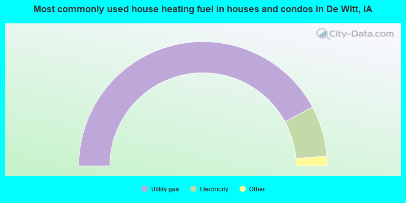
- 84.3%Utility gas
- 13.2%Electricity
- 1.8%Bottled, tank, or LP gas
- 0.6%Wood
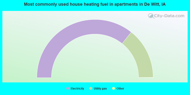
- 71.5%Electricity
- 28.5%Utility gas
De Witt compared to Iowa state average:
- Unemployed percentage significantly below state average.
- Black race population percentage significantly below state average.
- Hispanic race population percentage significantly below state average.
- Median age below state average.
- Length of stay since moving in significantly above state average.
- Percentage of population with a bachelor's degree or higher above state average.
De Witt on our top lists:
- #80 on the list of "Top 101 cities with the smallest percentage of likely homosexual households (counted as self-reported same-sex unmarried-partner households) (population 5,000+)"
- #99 on the list of "Top 101 cities with largest percentage of females in occupations: health technologists and technicians (population 5,000+)"

|
Total of 4 patent applications in 2008-2024.