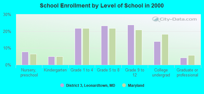
District 3, Leonardtown, Maryland
Submit your own pictures of this city and show them to the world
- OSM Map
- General Map
- Google Map
- MSN Map

| Males: 6,104 | |
| Females: 6,411 |
| Median resident age: | 37.7 years |
| Maryland median age: | 36.0 years |
Zip code: 20650
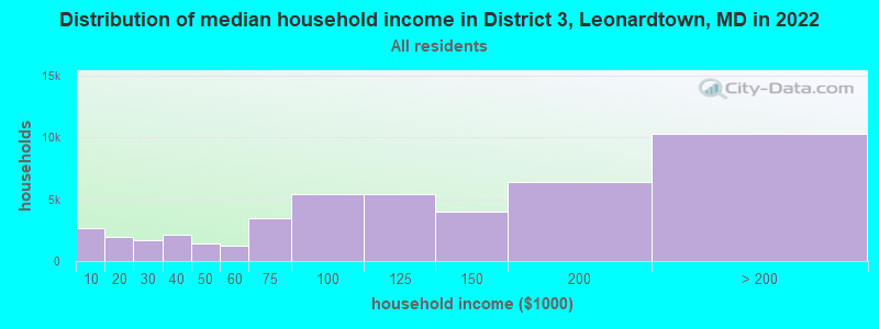
| District 3, Leonardtown: | $117,931 |
| MD: | $94,991 |
Estimated per capita income in 2022: $56,040 (it was $23,371 in 2000)
District 3, Leonardtown income, earnings, and wages data
Estimated median house or condo value in 2022: $443,138 (it was $166,500 in 2000)
| District 3, Leonardtown: | $443,138 |
| MD: | $398,100 |
Mean prices in 2022: all housing units: $420,835; detached houses: $434,448; townhouses or other attached units: $291,891; in 2-unit structures: $256,566; in 3-to-4-unit structures: $251,015; in 5-or-more-unit structures: $338,851; mobile homes: $282,703
District 3, Leonardtown, MD residents, houses, and apartments details
Detailed information about poverty and poor residents in District 3, Leonardtown, MD


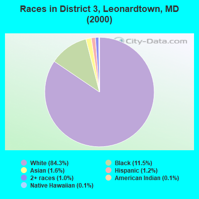
- 9,09084.3%White alone
- 1,24311.5%Black alone
- 1761.6%Asian alone
- 1341.2%Hispanic
- 1061.0%Two or more races
- 150.1%American Indian alone
- 110.1%Native Hawaiian and Other
Pacific Islander alone - 100.09%Other race alone
Races in District 3, Leonardtown detailed stats: ancestries, foreign born residents, place of birth
 Recent articles from our blog. Our writers, many of them Ph.D. graduates or candidates, create easy-to-read articles on a wide variety of topics.
Current Local Time: EST time zone
Land area: 64.7 square miles.
Population density: 193 people per square mile (very low).

| District 3, Leonardtown: | 0.8% ($1,387) |
| Maryland: | 1.2% ($1,782) |
Nearest city with pop. 50,000+: Alexandria, VA  (43.3 miles , pop. 128,283).
Nearest city with pop. 200,000+: Washington, DC (47.8 miles , pop. 572,059).
Nearest city with pop. 1,000,000+: Philadelphia, PA (143.6 miles , pop. 1,517,550).
Nearest cities:
), ), )Latitude: 38.28 N, Longitude: 76.65 W

| Here: | 1.9% |
| Maryland: | 2.0% |
- Public administration (18.6%)
- Construction (14.0%)
- Health care (8.3%)
- Educational services (8.1%)
- Professional, scientific, technical services (7.3%)
- Food & beverage stores (3.2%)
- Finance & insurance (2.7%)
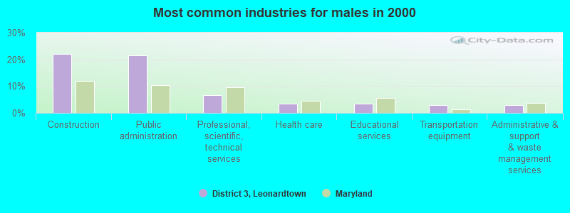
- Construction (22.2%)
- Public administration (21.4%)
- Professional, scientific, technical services (6.6%)
- Health care (3.4%)
- Educational services (3.4%)
- Transportation equipment (3.0%)
- Administrative & support & waste management services (2.8%)
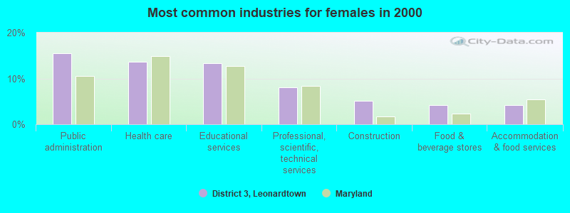
- Public administration (15.5%)
- Health care (13.7%)
- Educational services (13.3%)
- Professional, scientific, technical services (8.0%)
- Construction (5.1%)
- Food & beverage stores (4.2%)
- Accommodation & food services (4.2%)
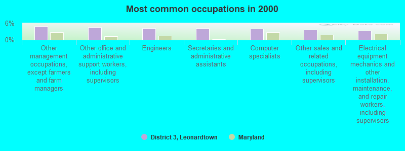
- Other management occupations, except farmers and farm managers (4.9%)
- Other office and administrative support workers, including supervisors (4.5%)
- Engineers (4.3%)
- Secretaries and administrative assistants (4.1%)
- Computer specialists (4.0%)
- Other sales and related occupations, including supervisors (3.6%)
- Electrical equipment mechanics and other installation, maintenance, and repair workers, including supervisors (3.3%)
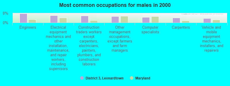
- Engineers (7.7%)
- Electrical equipment mechanics and other installation, maintenance, and repair workers, including supervisors (6.0%)
- Construction traders workers except carpenters, electricians, painters, plumbers, and construction laborers (5.8%)
- Other management occupations, except farmers and farm managers (5.4%)
- Computer specialists (4.6%)
- Carpenters (4.1%)
- Vehicle and mobile equipment mechanics, installers, and repairers (3.7%)
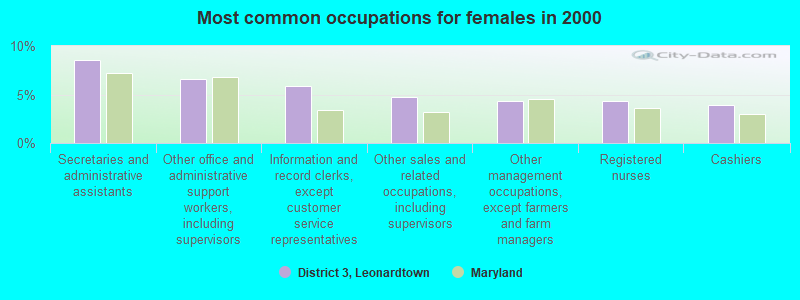
- Secretaries and administrative assistants (8.6%)
- Other office and administrative support workers, including supervisors (6.6%)
- Information and record clerks, except customer service representatives (5.8%)
- Other sales and related occupations, including supervisors (4.7%)
- Other management occupations, except farmers and farm managers (4.4%)
- Registered nurses (4.4%)
- Cashiers (3.9%)
Average climate in District 3, Leonardtown, Maryland
Based on data reported by over 4,000 weather stations


Tornado activity:
District 3, Leonardtown-area historical tornado activity is near Maryland state average. It is 12% smaller than the overall U.S. average.
On 4/28/2002, a category F4 (max. wind speeds 207-260 mph) tornado 16.0 miles away from the District 3, Leonardtown city center killed 3 people and injured 122 people and caused $124 million in damages.
On 4/28/2002, a category F3 (max. wind speeds 158-206 mph) tornado 21.4 miles away from the city center caused $150,000 in damages.
Earthquake activity:
District 3, Leonardtown-area historical earthquake activity is significantly above Maryland state average. It is 59% smaller than the overall U.S. average.On 8/23/2011 at 17:51:04, a magnitude 5.8 (5.8 MW, Depth: 3.7 mi, Class: Moderate, Intensity: VI - VII) earthquake occurred 74.5 miles away from the city center
On 8/25/2011 at 05:07:52, a magnitude 4.5 (4.5 ML, Depth: 4.2 mi, Class: Light, Intensity: IV - V) earthquake occurred 75.2 miles away from District 3, Leonardtown center
On 12/9/2003 at 20:59:14, a magnitude 4.5 (4.5 MB, 4.5 LG) earthquake occurred 83.5 miles away from the city center
On 12/9/2003 at 20:59:18, a magnitude 4.5 (4.5 ML, Depth: 6.2 mi) earthquake occurred 86.3 miles away from District 3, Leonardtown center
On 1/16/1994 at 01:49:16, a magnitude 4.6 (4.6 MB, 4.6 LG, Depth: 3.1 mi) earthquake occurred 145.4 miles away from the city center
On 8/24/2011 at 00:04:36, a magnitude 4.2 (4.2 ML) earthquake occurred 75.3 miles away from District 3, Leonardtown center
Magnitude types: regional Lg-wave magnitude (LG), body-wave magnitude (MB), local magnitude (ML), moment magnitude (MW)
Hospitals and medical centers near District 3, Leonardtown:
- MEDSTAR SAINT MARY'S HOSPITAL Acute Care Hospitals (about 2 miles away; LEONARDTOWN, MD)
- ST. MARY'S NURSING CENTER INC (Nursing Home, about 2 miles away; LEONARDTOWN, MD)
- CHESAPEAKE SHORES (Nursing Home, about 10 miles away; LEXINGTON PARK, MD)
- ASBURY SOLOMONS (Nursing Home, about 11 miles away; SOLOMONS, MD)
- SOLOMONS NURSING CENTER (Nursing Home, about 12 miles away; SOLOMONS, MD)
- CHARLOTTE HALL VETERANS HOME (Nursing Home, about 16 miles away; CHARLOTTE HALL, MD)
Operable nuclear power plants near District 3, Leonardtown:
- 13 miles: Calvert Cliffs 1 and 2 in Lusby, MD.
Colleges/universities with over 2000 students nearest to District 3, Leonardtown:
- College of Southern Maryland (about 28 miles; La Plata, MD; Full-time enrollment: 5,775)
- Strayer University-Maryland (about 41 miles; Suitland, MD; FT enrollment: 2,748)
- Prince George's Community College (about 43 miles; Largo, MD; FT enrollment: 8,537)
- University of Mary Washington (about 45 miles; Fredericksburg, VA; FT enrollment: 4,506)
- George Washington University (about 48 miles; Washington, DC; FT enrollment: 18,928)
- Strayer University-Global Region (about 48 miles; Washington, DC; FT enrollment: 2,613)
- Strayer University-Virginia (about 49 miles; Arlington, VA; FT enrollment: 7,005)
Points of interest:
Notable locations in District 3, Leonardtown: Faith Ridge Farm (A), Nuns Oak (B), Leonardtown Wharf (C), Greenbrier (D), Ellenborough (E), Leonardtown Wastewater Treatment Plant (F), Breton Bay Country Club (G), Bloomsbury (H), Combs Creek Marina (I), Abells Wharf (J), Bretons Bay (K), Camp Calvert (L), Camp Maria (M), Saint Marys County Government Center (N), Stones Wharf (O), Saint Marys County Sheriff's Office (P), Leonardtown Volunteer Fire Department Company 1 (Q), Saint Mary's County Library - Leonardtown Branch (R), Leonardtown Volunteer Rescue Squad (S), Valentine Hall (T). Display/hide their locations on the map
Shopping Center: Leonardtown Square Shopping Center (1). Display/hide its location on the map
Churches in District 3, Leonardtown include: Our Ladys Chapel (A), Saint Aloysius Church (B), Saint Francis Xavier Church (C), Stauffer Church (D), Leonardtown Baptist Church (E), Patuxent Seventh Day Adventist Church (F), Saint Pauls United Methodist Church (G), Saint Peters Episcopal Church (H). Display/hide their locations on the map
Cemeteries: Saint Francis Xavier Cemetery (1), Charles Memorial Gardens (2), New Saint Aloysius Cemetery (3), Old Saint Aloysius Cemetery (4), Saint Pauls Cemetery (5), Our Ladys Chapel Cemetery (6). Display/hide their locations on the map
Lakes and reservoirs: Fresh Pond (A), Ledford Farm Pond (B). Display/hide their locations on the map
Streams, rivers, and creeks: Saint Williams Creek (A), Town Run (B), Tenneson Creek (C), Spring Brook (D), Poplar Hill Creek (E), Nelson Run (F), Moll Dyers Run (G), Miski Run (H), McIntosh Run (I). Display/hide their locations on the map
Parks in District 3, Leonardtown include: Saint Clement Shores Park (1), Indian Village Archeological Park (2), Leonardtown Park (3). Display/hide their locations on the map
| This city: | 2.8 people |
| Maryland: | 2.6 people |
| This city: | 75.1% |
| Whole state: | 67.1% |
| This city: | 5.8% |
| Whole state: | 6.4% |
Likely homosexual households (counted as self-reported same-sex unmarried-partner households)
- Lesbian couples: 0.4% of all households
- Gay men: 0.2% of all households
| This city: | 7.6% |
| Whole state: | 8.5% |
| This city: | 3.3% |
| Whole state: | 4.2% |
People in group quarters in District 3, Leonardtown in 2010:
- 251 people in local jails and other municipal confinement facilities
- 156 people in nursing facilities/skilled-nursing facilities
- 28 people in other noninstitutional facilities
- 13 people in residential treatment centers for adults
- 5 people in group homes intended for adults
People in group quarters in District 3, Leonardtown in 2000:
- 207 people in other noninstitutional group quarters
- 198 people in nursing homes
- 139 people in local jails and other confinement facilities (including police lockups)
- 15 people in homes or halfway houses for drug/alcohol abuse
- 11 people in homes for the physically handicapped
- 5 people in hospitals/wards and hospices for chronically ill
- 5 people in other hospitals or wards for chronically ill
- 5 people in religious group quarters
- 4 people in homes for the mentally retarded
For population 15 years and over in District 3, Leonardtown:
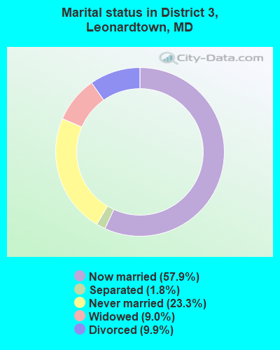
- Never married: 23.3%
- Now married: 57.9%
- Separated: 1.8%
- Widowed: 9.0%
- Divorced: 9.9%
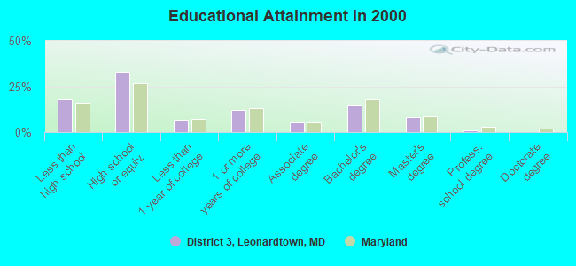
For population 25 years and over in District 3, Leonardtown:
- High school or higher: 82.0%
- Bachelor's degree or higher: 24.7%
- Graduate or professional degree: 9.7%
- Unemployed: 4.1%
- Mean travel time to work (commute): 28.1 minutes
| Here: | 11.8 |
| Maryland average: | 12.7 |
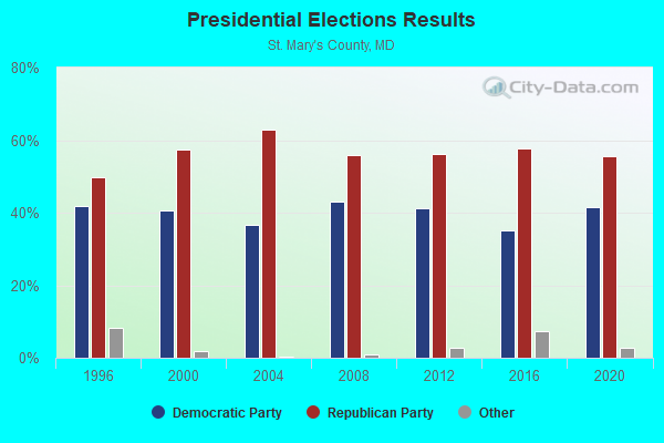
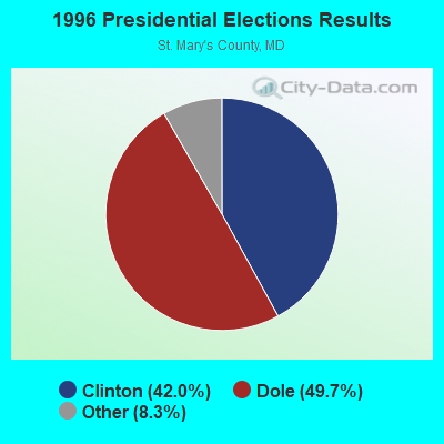

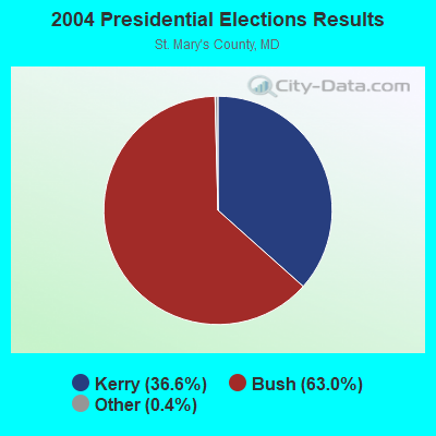
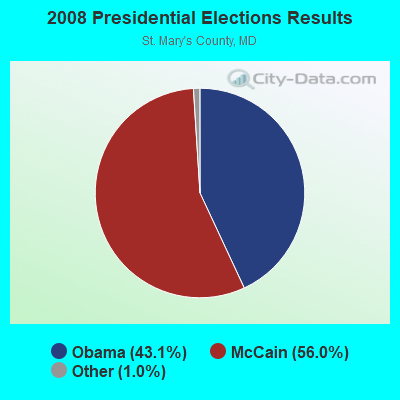
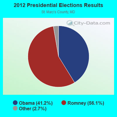
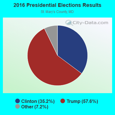
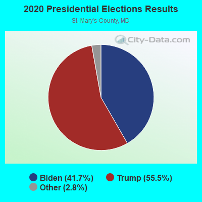
Graphs represent county-level data. Detailed 2008 Election Results
Religion statistics for District 3, Leonardtown, MD (based on St. Mary's County data)
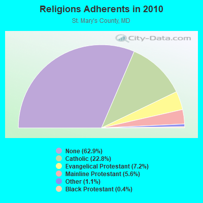
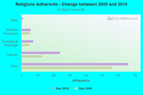
| Religion | Adherents | Congregations |
|---|---|---|
| Catholic | 24,014 | 15 |
| Evangelical Protestant | 7,519 | 35 |
| Mainline Protestant | 5,862 | 21 |
| Other | 1,206 | 7 |
| Black Protestant | 377 | 3 |
| None | 66,173 | - |
Food Environment Statistics:
| This county: | 1.60 / 10,000 pop. |
| Maryland: | 1.96 / 10,000 pop. |
| St. Mary's County: | 0.10 / 10,000 pop. |
| State: | 0.07 / 10,000 pop. |
| St. Mary's County: | 1.00 / 10,000 pop. |
| Maryland: | 1.22 / 10,000 pop. |
| St. Mary's County: | 2.79 / 10,000 pop. |
| Maryland: | 2.05 / 10,000 pop. |
| This county: | 5.59 / 10,000 pop. |
| Maryland: | 5.40 / 10,000 pop. |
| Here: | 8.4% |
| State: | 9.1% |
| This county: | 28.9% |
| Maryland: | 26.7% |
| This county: | 16.8% |
| Maryland: | 15.5% |
7.37% of this county's 2021 resident taxpayers lived in other counties in 2020 ($70,801 average adjusted gross income)
| Here: | 7.37% |
| Maryland average: | 7.42% |
0.13% of residents moved from foreign countries ($1,142 average AGI)
St. Mary's County: 0.13% Maryland average: 0.05%
Top counties from which taxpayers relocated into this county between 2020 and 2021:
| from Charles County, MD | |
| from Calvert County, MD | |
| from Prince George's County, MD |
7.28% of this county's 2020 resident taxpayers moved to other counties in 2021 ($75,710 average adjusted gross income)
| Here: | 7.28% |
| Maryland average: | 7.91% |
0.09% of residents moved to foreign countries ($968 average AGI)
St. Mary's County: 0.09% Maryland average: 0.04%
Top counties to which taxpayers relocated from this county between 2020 and 2021:
| to Calvert County, MD | |
| to Charles County, MD | |
| to Prince George's County, MD |
Strongest AM radio stations in District 3, Leonardtown:
- WPTX (1690 AM; 10 kW; LEXINGTON PARK, MD; Owner: SOMAR COMMUNICATIONS, INC.)
- WWGB (1030 AM; daytime; 50 kW; INDIAN HEAD, MD; Owner: GOOD BODY MEDIA, LLC)
- WTEM (980 AM; 50 kW; WASHINGTON, DC; Owner: AMFM RADIO LICENSES, L.L.C.)
- WBIS (1190 AM; 50 kW; ANNAPOLIS, MD; Owner: NATIONS RADIO, LLC)
- WPGC (1580 AM; 50 kW; MORNINGSIDE, MD; Owner: INFINITY WPGC(AM), INC.)
- WCBM (680 AM; 50 kW; BALTIMORE, MD; Owner: WCBM MARYLAND, INC.)
- WTOP (1500 AM; 50 kW; WASHINGTON, DC; Owner: BONNEVILLE HOLDING COMPANY)
- WMET (1150 AM; 50 kW; GAITHERSBURG, MD; Owner: BELTWAY ACQUISITION CORPORATION)
- WRVA (1140 AM; 50 kW; RICHMOND, VA; Owner: CLEAR CHANNEL BROADCASTING LICENSES, INC.)
- WTAR (850 AM; 50 kW; NORFOLK, VA; Owner: SINCLAIR COMMUNICATIONS)
- WBAL (1090 AM; 50 kW; BALTIMORE, MD; Owner: HEARST RADIO, INC.)
- WKCW (1420 AM; 50 kW; WARRENTON, VA; Owner: WAY BROADCASTING, INC.)
- WWLG (1370 AM; 50 kW; BALTIMORE, MD; Owner: M-10 BROADCASTING, INC.)
Strongest FM radio stations in District 3, Leonardtown:
- WMDM-FM (97.7 FM; LEXINGTON PARK, MD; Owner: SOMAR COMMUNICATIONS, INC.)
- WKIK-FM (102.9 FM; CALIFORNIA, MD; Owner: SOMAR COMMUNICATIONS, INC.)
- WSMD-FM (98.3 FM; MECHANICSVILLE, MD; Owner: SOMAR COMMUNICATIONS, INC.)
- WWZZ (104.1 FM; WALDORF, MD; Owner: BONNEVILLE HOLDING COMPANY)
- WGRQ (95.9 FM; COLONIAL BEACH, VA; Owner: TELEMEDIA BROADCASTING, INC.)
- WBZS-FM (92.7 FM; PRINCE FREDERICK, MD; Owner: MEGA COMMUNICATIONS OF PRINCE FREDERICK LICENSEE, LLC)
- WNNT-FM (100.9 FM; WARSAW, VA; Owner: NORTHERN NECK & TIDEWATER COMMUNICATIONS, INC)
- WRAR-FM (105.5 FM; TAPPAHANNOCK, VA; Owner: RAPPAHANNOCK COMMUNICATIONS, INC.)
TV broadcast stations around District 3, Leonardtown:
- W52AX (Channel 52; LEONARDTOWN, MD; Owner: SATELLITE VIDEO BROADCASTING)
- WIAV-LP (Channel 58; WASHINGTON, DC; Owner: ASIAVISION, INC.)
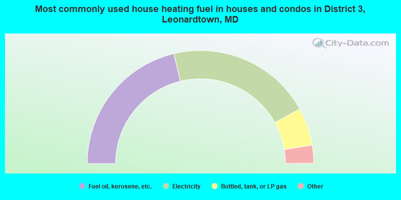
- 42.4%Fuel oil, kerosene, etc.
- 41.5%Electricity
- 10.8%Bottled, tank, or LP gas
- 3.8%Wood
- 0.6%Coal or coke
- 0.5%No fuel used
- 0.4%Other fuel
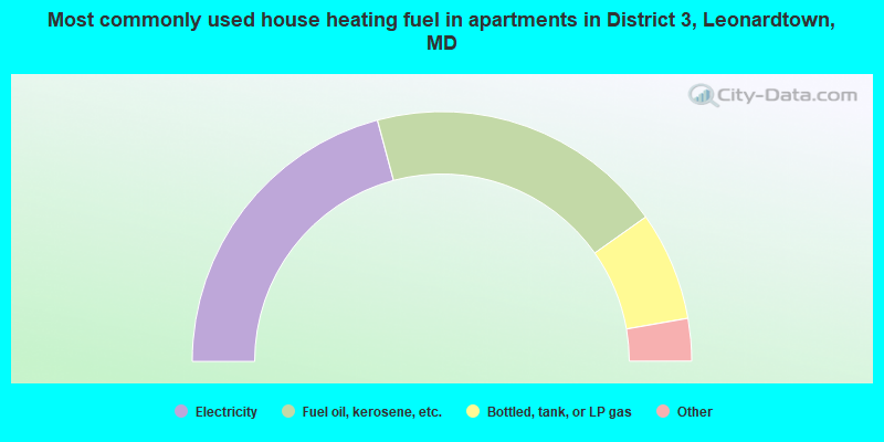
- 41.7%Electricity
- 38.7%Fuel oil, kerosene, etc.
- 14.1%Bottled, tank, or LP gas
- 2.1%Utility gas
- 1.8%Wood
- 1.0%No fuel used
- 0.7%Other fuel
District 3, Leonardtown compared to Maryland state average:
- Unemployed percentage significantly below state average.
- Black race population percentage below state average.
- Hispanic race population percentage significantly below state average.
- Foreign-born population percentage significantly below state average.
- Length of stay since moving in significantly above state average.
- Number of rooms per house significantly below state average.
- House age significantly below state average.
- Institutionalized population percentage above state average.
District 3, Leonardtown on our top lists:
- #4 on the list of "Top 101 cities with largest percentage of males in industries: petroleum and petroleum products merchant wholesalers (population 5,000+)"
- #22 on the list of "Top 101 cities with largest percentage of males in occupations: business operations specialists (population 5,000+)"
- #33 on the list of "Top 101 cities with largest percentage of males in occupations: engineers (population 5,000+)"
- #43 on the list of "Top 101 cities with largest percentage of males in occupations: drafters, engineering, and mapping technicians (population 5,000+)"
- #67 on the list of "Top 101 cities with largest percentage of males in occupations: construction trades workers except carpenters, electricians, painters, plumbers, and construction laborers (population 5,000+)"
- #70 on the list of "Top 101 cities with largest percentage of females in occupations: operations specialties managers except financial managers (population 5,000+)"
- #81 on the list of "Top 101 cities with largest percentage of females in occupations: business operations specialists (population 5,000+)"
- #61 on the list of "Top 101 counties with the largest number of people moving in compared to moving out (pop. 50,000+)"
- #79 on the list of "Top 101 counties with the lowest total withdrawal of fresh water for public supply (pop. 50,000+)"
- #90 on the list of "Top 101 counties with the highest percentage of residents relocating to foreign countries in 2011 (pop. 50,000+)"
- #98 on the list of "Top 101 counties with the highest percentage of residents relocating from foreign countries between 2010 and 2011"