District 8, Bryantown, Maryland
Submit your own pictures of this city and show them to the world
- OSM Map
- General Map
- Google Map
- MSN Map

| Males: 7,381 | |
| Females: 7,246 |
| Median resident age: | 39.3 years |
| Maryland median age: | 36.0 years |
Zip code: 20601
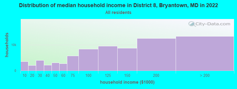
| District 8, Bryantown: | $140,608 |
| MD: | $94,991 |
Estimated per capita income in 2022: $52,984 (it was $27,208 in 2000)
District 8, Bryantown income, earnings, and wages data
Estimated median house or condo value in 2022: $422,923 (it was $162,500 in 2000)
| District 8, Bryantown: | $422,923 |
| MD: | $398,100 |
Mean prices in 2022: all housing units: $421,884; detached houses: $448,816; townhouses or other attached units: $287,336; in 2-unit structures: $223,968; in 3-to-4-unit structures: $232,479; in 5-or-more-unit structures: $265,223; mobile homes: $64,617; occupied boats, rvs, vans, etc.: $454,094
District 8, Bryantown, MD residents, houses, and apartments details
Detailed information about poverty and poor residents in District 8, Bryantown, MD


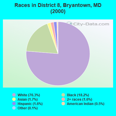
- 9,61176.3%White alone
- 2,29718.2%Black alone
- 2091.7%Asian alone
- 2031.6%Two or more races
- 2011.6%Hispanic
- 640.5%American Indian alone
- 130.1%Other race alone
- 50.04%Native Hawaiian and Other
Pacific Islander alone
Races in District 8, Bryantown detailed stats: ancestries, foreign born residents, place of birth
 Recent articles from our blog. Our writers, many of them Ph.D. graduates or candidates, create easy-to-read articles on a wide variety of topics.
Current Local Time: EST time zone
Land area: 69.9 square miles.
Population density: 209 people per square mile (very low).

| District 8, Bryantown: | 1.0% ($1,704) |
| Maryland: | 1.2% ($1,782) |
Nearest city with pop. 50,000+: Alexandria, VA  (19.6 miles , pop. 128,283).
Nearest city with pop. 200,000+: Washington, DC (24.0 miles , pop. 572,059).
Nearest city with pop. 1,000,000+: Philadelphia, PA (133.6 miles , pop. 1,517,550).
Nearest cities:
), ), ), ), ), ), Latitude: 38.59 N, Longitude: 76.85 W

| Here: | 2.1% |
| Maryland: | 2.0% |
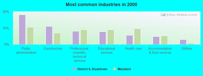
- Public administration (18.1%)
- Construction (11.1%)
- Professional, scientific, technical services (8.1%)
- Educational services (7.8%)
- Health care (5.6%)
- Accommodation & food services (4.8%)
- Utilities (3.0%)
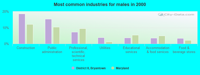
- Construction (18.7%)
- Public administration (15.4%)
- Professional, scientific, technical services (7.3%)
- Utilities (3.9%)
- Educational services (3.7%)
- Accommodation & food services (3.6%)
- Food & beverage stores (3.4%)
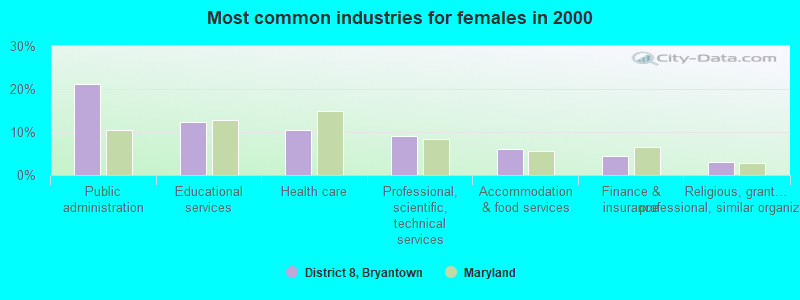
- Public administration (21.1%)
- Educational services (12.3%)
- Health care (10.3%)
- Professional, scientific, technical services (9.1%)
- Accommodation & food services (6.1%)
- Finance & insurance (4.5%)
- Religious, grantmaking, civic, professional, similar organizations (3.0%)
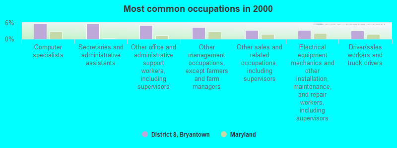
- Computer specialists (5.8%)
- Secretaries and administrative assistants (5.7%)
- Other office and administrative support workers, including supervisors (5.2%)
- Other management occupations, except farmers and farm managers (4.4%)
- Other sales and related occupations, including supervisors (3.2%)
- Electrical equipment mechanics and other installation, maintenance, and repair workers, including supervisors (3.2%)
- Driver/sales workers and truck drivers (3.1%)
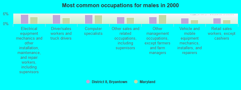
- Electrical equipment mechanics and other installation, maintenance, and repair workers, including supervisors (5.6%)
- Driver/sales workers and truck drivers (5.5%)
- Computer specialists (5.4%)
- Other sales and related occupations, including supervisors (4.1%)
- Other management occupations, except farmers and farm managers (4.1%)
- Vehicle and mobile equipment mechanics, installers, and repairers (3.5%)
- Retail sales workers, except cashiers (3.4%)
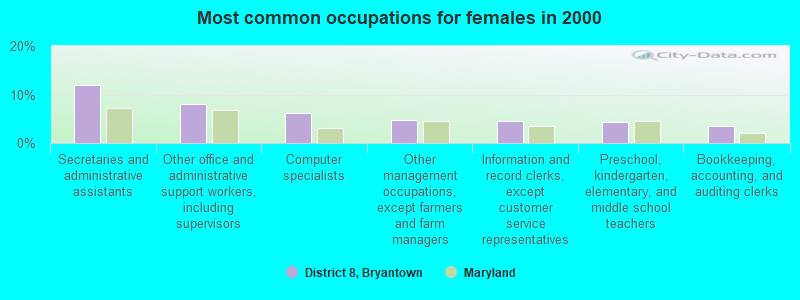
- Secretaries and administrative assistants (12.1%)
- Other office and administrative support workers, including supervisors (8.1%)
- Computer specialists (6.2%)
- Other management occupations, except farmers and farm managers (4.8%)
- Information and record clerks, except customer service representatives (4.4%)
- Preschool, kindergarten, elementary, and middle school teachers (4.3%)
- Bookkeeping, accounting, and auditing clerks (3.4%)
Average climate in District 8, Bryantown, Maryland
Based on data reported by over 4,000 weather stations


(lower is better)
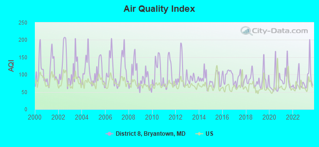
Air Quality Index (AQI) level in 2023 was 94.6. This is worse than average.
| City: | 94.6 |
| U.S.: | 72.6 |
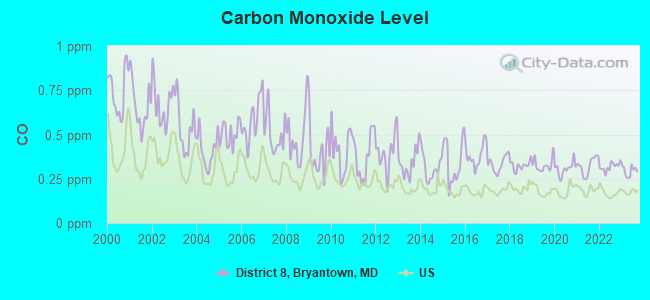
Carbon Monoxide (CO) [ppm] level in 2023 was 0.293. This is about average. Closest monitor was 16.1 miles away from the city center.
| City: | 0.293 |
| U.S.: | 0.251 |
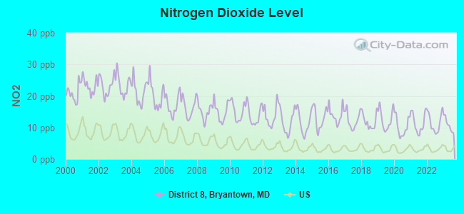
Nitrogen Dioxide (NO2) [ppb] level in 2023 was 10.9. This is significantly worse than average. Closest monitor was 4.8 miles away from the city center.
| City: | 10.9 |
| U.S.: | 5.1 |
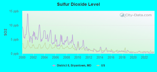
Sulfur Dioxide (SO2) [ppb] level in 2023 was 0.291. This is significantly better than average. Closest monitor was 4.8 miles away from the city center.
| City: | 0.291 |
| U.S.: | 1.515 |
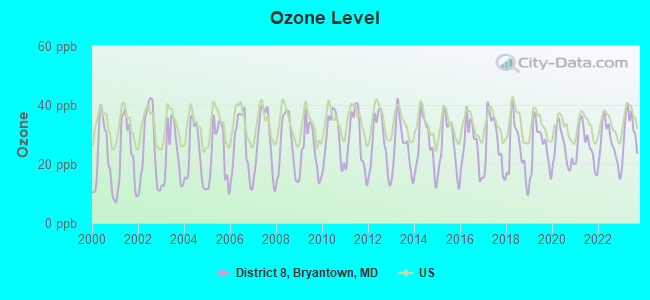
Ozone [ppb] level in 2023 was 31.2. This is about average. Closest monitor was 6.0 miles away from the city center.
| City: | 31.2 |
| U.S.: | 33.3 |
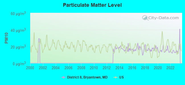
Particulate Matter (PM10) [µg/m3] level in 2022 was 13.7. This is significantly better than average. Closest monitor was 16.1 miles away from the city center.
| City: | 13.7 |
| U.S.: | 19.2 |
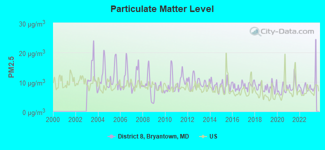
Particulate Matter (PM2.5) [µg/m3] level in 2022 was 7.79. This is about average. Closest monitor was 16.5 miles away from the city center.
| City: | 7.79 |
| U.S.: | 8.11 |
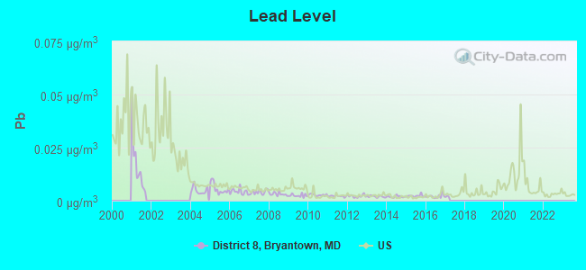
Lead (Pb) [µg/m3] level in 2016 was 0.00212. This is significantly better than average. Closest monitor was 4.8 miles away from the city center.
| City: | 0.00212 |
| U.S.: | 0.00931 |
Tornado activity:
District 8, Bryantown-area historical tornado activity is near Maryland state average. It is 1% greater than the overall U.S. average.
On 4/28/2002, a category F4 (max. wind speeds 207-260 mph) tornado 17.9 miles away from the District 8, Bryantown city center killed 3 people and injured 122 people and caused $124 million in damages.
On 9/5/1979, a category F3 (max. wind speeds 158-206 mph) tornado 18.0 miles away from the city center killed one person and injured 6 people and caused between $500,000 and $5,000,000 in damages.
Earthquake activity:
District 8, Bryantown-area historical earthquake activity is significantly above Maryland state average. It is 58% smaller than the overall U.S. average.On 8/23/2011 at 17:51:04, a magnitude 5.8 (5.8 MW, Depth: 3.7 mi, Class: Moderate, Intensity: VI - VII) earthquake occurred 75.3 miles away from District 8, Bryantown center
On 8/25/2011 at 05:07:52, a magnitude 4.5 (4.5 ML, Depth: 4.2 mi, Class: Light, Intensity: IV - V) earthquake occurred 75.1 miles away from the city center
On 12/9/2003 at 20:59:18, a magnitude 4.5 (4.5 ML, Depth: 6.2 mi) earthquake occurred 88.2 miles away from the city center
On 12/9/2003 at 20:59:14, a magnitude 4.5 (4.5 MB, 4.5 LG) earthquake occurred 89.8 miles away from District 8, Bryantown center
On 1/16/1994 at 01:49:16, a magnitude 4.6 (4.6 MB, 4.6 LG, Depth: 3.1 mi) earthquake occurred 128.0 miles away from District 8, Bryantown center
On 8/24/2011 at 00:04:36, a magnitude 4.2 (4.2 ML) earthquake occurred 75.9 miles away from the city center
Magnitude types: regional Lg-wave magnitude (LG), body-wave magnitude (MB), local magnitude (ML), moment magnitude (MW)
Natural disasters:
The number of natural disasters in Charles County (21) is greater than the US average (15).Major Disasters (Presidential) Declared: 16
Emergencies Declared: 5
Causes of natural disasters: Hurricanes: 7, Winter Storms: 6, Snowstorms: 4, Storms: 2, Tropical Storms: 2, Blizzard: 1, Flood: 1, Heavy Rain: 1, Ice Storm: 1, Snowfall: 1, Tornado: 1, Wind: 1, Other: 1 (Note: some incidents may be assigned to more than one category).
Hospitals and medical centers near District 8, Bryantown:
- FMC - WALDORF (Dialysis Facility, about 4 miles away; WALDORF, MD)
- WALDORF SURGICAL CTR AKA MED AND SUR CLINI (Hospital, about 4 miles away; WALDORF, MD)
- CHESAPEAKE POTOMAC HHA (Home Health Center, about 4 miles away; HUGHESVILLE, MD)
- WALDORF CENTER (Nursing Home, about 5 miles away; WALDORF, MD)
- UNIVERSITY OF MD CHARLES REGIONAL MEDICAL CENTER Acute Care Hospitals (about 8 miles away; LA PLATA, MD)
- LAPLATA CENTER (Nursing Home, about 9 miles away; LAPLATA, MD)
- CHARLOTTE HALL VETERANS HOME (Nursing Home, about 9 miles away; CHARLOTTE HALL, MD)
Amtrak station near District 8, Bryantown:
- 19 miles: ALEXANDRIA (110 CALLAHAN DR.) . Services: ticket office, partially wheelchair accessible, enclosed waiting area, public restrooms, public payphones, vending machines, ATM, free short-term parking, free long-term parking, call for car rental service, call for taxi service, public transit connection.
Colleges/universities with over 2000 students nearest to District 8, Bryantown:
- College of Southern Maryland (about 9 miles; La Plata, MD; Full-time enrollment: 5,775)
- Strayer University-Maryland (about 17 miles; Suitland, MD; FT enrollment: 2,748)
- Prince George's Community College (about 21 miles; Largo, MD; FT enrollment: 8,537)
- George Washington University (about 24 miles; Washington, DC; FT enrollment: 18,928)
- Strayer University-Global Region (about 24 miles; Washington, DC; FT enrollment: 2,613)
- Strayer University-Virginia (about 25 miles; Arlington, VA; FT enrollment: 7,005)
- Howard University (about 25 miles; Washington, DC; FT enrollment: 7,838)
Points of interest:
Notable locations in District 8, Bryantown: Burnt Store (A), Middleton's Cedar Hill Farm (B), Timbuktu Arabian Horse Farm (C), Brim Farm (D), Gallant Green (E), Olivers Shop (F), Southern Maryland Public Works Camp (G), Metro Gun Club (H). Display/hide their locations on the map
Churches in District 8, Bryantown include: Forest Park Baptist Church (A), Grace Brethren Church (B), New Covenant Church (C), Saint Charles Church of the Nazarene (D), Saint Mary Catholic Church (E), Saint Peters Catholic Church (F). Display/hide their locations on the map
Cemeteries: Saint Peters Cemetery (1), Saint Marys Cemetery (2). Display/hide their locations on the map
Reservoirs and swamps: Jameson Reservoir (A), Wheatley Reservoir (B), Gilbert Run Lake (C), Gilbert Pond (D), Hughesville Pond (E), Cedarville Pond (F), Jordan Swamp (G). Display/hide their locations on the map
Streams, rivers, and creeks: Piney Branch (A), Mill Dam Run (B), Stoner Creek (C), Wolf Den Branch (D). Display/hide their locations on the map
Parks in District 8, Bryantown include: Pinefield Community Park (1), Tilghman Park (2), Robert Stethem Memorial Complex (3), Gilbert Run Regional Park (4), Western Regional Park (5), Hughesville Pond Recreation Area (6), Bryantown Historic District (7), Tilghman Park (8), Cedarville Natural Resources Management Area (9). Display/hide their locations on the map
| This city: | 2.9 people |
| Maryland: | 2.6 people |
| This city: | 80.2% |
| Whole state: | 67.1% |
| This city: | 5.2% |
| Whole state: | 6.4% |
Likely homosexual households (counted as self-reported same-sex unmarried-partner households)
- Lesbian couples: 0.4% of all households
- Gay men: 0.2% of all households
| This city: | 2.6% |
| Whole state: | 8.5% |
| This city: | 1.3% |
| Whole state: | 4.2% |
People in group quarters in District 8, Bryantown in 2010:
- 174 people in correctional residential facilities
- 34 people in emergency and transitional shelters (with sleeping facilities) for people experiencing homelessness
- 24 people in group homes intended for adults
- 8 people in nursing facilities/skilled-nursing facilities
- 5 people in workers' group living quarters and job corps centers
People in group quarters in District 8, Bryantown in 2000:
- 174 people in state prisons
- 44 people in other group homes
- 9 people in homes for the mentally retarded
- 5 people in agriculture workers' dormitories on farms
- 3 people in religious group quarters
For population 15 years and over in District 8, Bryantown:
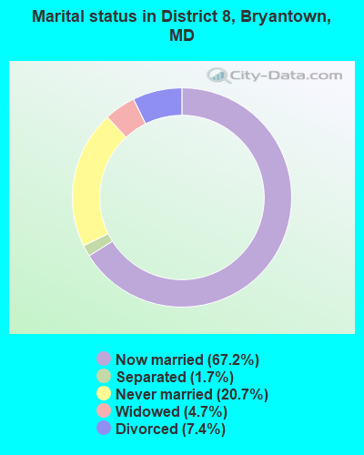
- Never married: 20.7%
- Now married: 67.2%
- Separated: 1.7%
- Widowed: 4.7%
- Divorced: 7.4%
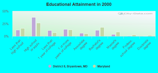
For population 25 years and over in District 8, Bryantown:
- High school or higher: 87.6%
- Bachelor's degree or higher: 17.8%
- Graduate or professional degree: 5.6%
- Unemployed: 1.8%
- Mean travel time to work (commute): 38.8 minutes
| Here: | 9.5 |
| Maryland average: | 12.7 |
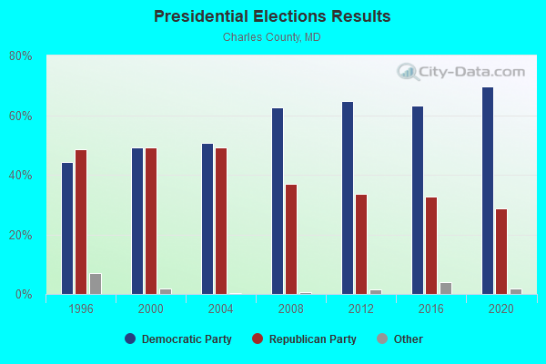
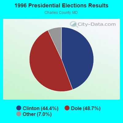
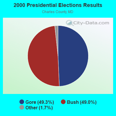
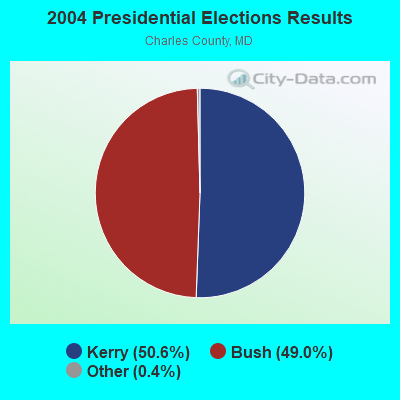
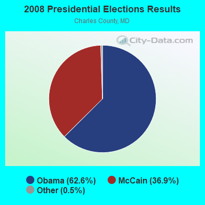
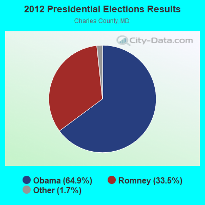
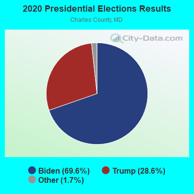
Graphs represent county-level data. Detailed 2008 Election Results
Religion statistics for District 8, Bryantown, MD (based on Charles County data)
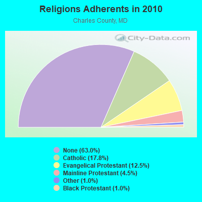
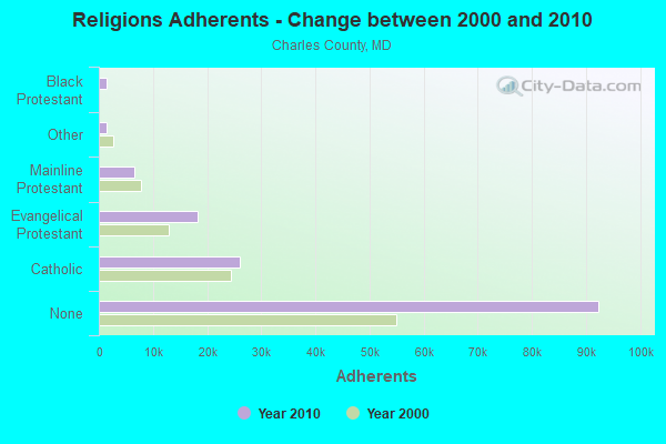
| Religion | Adherents | Congregations |
|---|---|---|
| Catholic | 26,146 | 12 |
| Evangelical Protestant | 18,323 | 72 |
| Mainline Protestant | 6,593 | 28 |
| Other | 1,512 | 7 |
| Black Protestant | 1,489 | 9 |
| Orthodox | 100 | 1 |
| None | 92,388 | - |
Food Environment Statistics:
| Here: | 1.57 / 10,000 pop. |
| State: | 1.96 / 10,000 pop. |
| Here: | 0.14 / 10,000 pop. |
| State: | 0.07 / 10,000 pop. |
| Here: | 1.14 / 10,000 pop. |
| Maryland: | 1.22 / 10,000 pop. |
| This county: | 2.21 / 10,000 pop. |
| Maryland: | 2.05 / 10,000 pop. |
| Charles County: | 4.78 / 10,000 pop. |
| Maryland: | 5.40 / 10,000 pop. |
| This county: | 9.2% |
| Maryland: | 9.1% |
| This county: | 31.9% |
| Maryland: | 26.7% |
| Here: | 13.0% |
| State: | 15.5% |
8.84% of this county's 2021 resident taxpayers lived in other counties in 2020 ($64,163 average adjusted gross income)
| Here: | 8.84% |
| Maryland average: | 7.42% |
0.09% of residents moved from foreign countries ($733 average AGI)
Charles County: 0.09% Maryland average: 0.05%
Top counties from which taxpayers relocated into this county between 2020 and 2021:
| from Prince George's County, MD | |
| from District of Columbia, DC | |
| from St. Mary's County, MD |
8.30% of this county's 2020 resident taxpayers moved to other counties in 2021 ($68,972 average adjusted gross income)
| Here: | 8.30% |
| Maryland average: | 7.91% |
0.07% of residents moved to foreign countries ($634 average AGI)
Charles County: 0.07% Maryland average: 0.04%
Top counties to which taxpayers relocated from this county between 2020 and 2021:
| to Prince George's County, MD | |
| to St. Mary's County, MD | |
| to Calvert County, MD |
Strongest AM radio stations in District 8, Bryantown:
- WWGB (1030 AM; daytime; 50 kW; INDIAN HEAD, MD; Owner: GOOD BODY MEDIA, LLC)
- WPGC (1580 AM; 50 kW; MORNINGSIDE, MD; Owner: INFINITY WPGC(AM), INC.)
- WTEM (980 AM; 50 kW; WASHINGTON, DC; Owner: AMFM RADIO LICENSES, L.L.C.)
- WBIS (1190 AM; 50 kW; ANNAPOLIS, MD; Owner: NATIONS RADIO, LLC)
- WKDL (730 AM; 8 kW; ALEXANDRIA, VA; Owner: MEGA COMMUNICATIONS OF ALEXANDRIA LICENSEE, LLC)
- WTOP (1500 AM; 50 kW; WASHINGTON, DC; Owner: BONNEVILLE HOLDING COMPANY)
- WCBM (680 AM; 50 kW; BALTIMORE, MD; Owner: WCBM MARYLAND, INC.)
- WUST (1120 AM; daytime; 20 kW; WASHINGTON, DC)
- WMET (1150 AM; 50 kW; GAITHERSBURG, MD; Owner: BELTWAY ACQUISITION CORPORATION)
- WBAL (1090 AM; 50 kW; BALTIMORE, MD; Owner: HEARST RADIO, INC.)
- WKCW (1420 AM; 50 kW; WARRENTON, VA; Owner: WAY BROADCASTING, INC.)
- WWLG (1370 AM; 50 kW; BALTIMORE, MD; Owner: M-10 BROADCASTING, INC.)
- WGOP (700 AM; daytime; 25 kW; WALKERSVILLE, MD; Owner: BIRACH BROADCASTING CORPORATION)
Strongest FM radio stations in District 8, Bryantown:
- WWZZ (104.1 FM; WALDORF, MD; Owner: BONNEVILLE HOLDING COMPANY)
- WBZS-FM (92.7 FM; PRINCE FREDERICK, MD; Owner: MEGA COMMUNICATIONS OF PRINCE FREDERICK LICENSEE, LLC)
- WSMD-FM (98.3 FM; MECHANICSVILLE, MD; Owner: SOMAR COMMUNICATIONS, INC.)
- WPGC-FM (95.5 FM; MORNINGSIDE, MD; Owner: INFINITY BROADCASTING CORPORATION OF MARYLAND)
- WRQX (107.3 FM; WASHINGTON, DC; Owner: WMAL, INC.)
- WHFS (99.1 FM; ANNAPOLIS, MD; Owner: INFINITY BROADCASTING OPERATIONS, INC.)
- WHUR-FM (96.3 FM; WASHINGTON, DC; Owner: THE HOWARD UNIVERSITY)
- WASH (97.1 FM; WASHINGTON, DC; Owner: AMFM RADIO LICENSES, L.L.C.)
- WJFK-FM (106.7 FM; MANASSAS, VA; Owner: INFINITY BROADCASTING CORP. OF WASHINGTON, DC)
- WKYS (93.9 FM; WASHINGTON, DC; Owner: RADIO ONE LICENSES, LLC)
- WARW (94.7 FM; BETHESDA, MD; Owner: INFINITY BROADCASTING OPERATIONS, INC.)
- WIHT (99.5 FM; WASHINGTON, DC; Owner: AMFM RADIO LICENSES, L.L.C.)
- WETA (90.9 FM; WASHINGTON, DC; Owner: GREATER WASHINGTON EDUCATIONAL TELECOMMUNICATIONS ASSN.)
- WWDC-FM (101.1 FM; WASHINGTON, DC; Owner: AMFM RADIO LICENSES, L.L.C.)
- WGTS (91.9 FM; TAKOMA PARK, MD; Owner: COLUMBIA UNION COLLEGE BROADCASTING, INC.)
- WJZW (105.9 FM; WOODBRIDGE, VA; Owner: WMAL, INC.)
- WBIG-FM (100.3 FM; WASHINGTON, DC; Owner: AMFM RADIO LICENSES, L.L.C.)
- WGRQ (95.9 FM; COLONIAL BEACH, VA; Owner: TELEMEDIA BROADCASTING, INC.)
- WKIK-FM (102.9 FM; CALIFORNIA, MD; Owner: SOMAR COMMUNICATIONS, INC.)
- WAVA (105.1 FM; ARLINGTON, VA; Owner: SALEM MEDIA OF VIRGINIA, INC.)
TV broadcast stations around District 8, Bryantown:
- WIAV-LP (Channel 58; WASHINGTON, DC; Owner: ASIAVISION, INC.)
- WJLA-TV (Channel 7; WASHINGTON, DC; Owner: ACC LICENSEE, INC.)
- WUSA (Channel 9; WASHINGTON, DC; Owner: THE DETROIT NEWS, INC.)
- WTTG (Channel 5; WASHINGTON, DC; Owner: FOX TELEVISION STATIONS, INC.)
- WMPT (Channel 22; ANNAPOLIS, MD; Owner: MARYLAND PUBLIC BROADCASTING COMMISSION)
- WBDC-TV (Channel 50; WASHINGTON, DC; Owner: WBDC BROADCASTING, INC.)
- WETA-TV (Channel 26; WASHINGTON, DC; Owner: THE GREATER WASHINGTON ED TELECOMM. ASSOC)
- WHUT-TV (Channel 32; WASHINGTON, DC; Owner: HOWARD UNIVERSITY)
- WDCA (Channel 20; WASHINGTON, DC; Owner: FOX TELEVISION STATIONS, INC.)
- WRC-TV (Channel 4; WASHINGTON, DC; Owner: NBC SUBSIDIARY (WRC-TV), INC.)
- WNVC (Channel 56; FAIRFAX, VA; Owner: COMMONWEALTH PUBLIC BROADCASTING CORPORATION)
- WNVT (Channel 53; GOLDVEIN, VA; Owner: COMMONWEALTH PUBLIC BROADCASTING CORPORATION)
- WPXW (Channel 66; MANASSAS, VA; Owner: PAXSON WASHINGTON LICENSE, INC.)
- W28BY (Channel 63; BALTIMORE, MD; Owner: INFORMATION SUPER STATION, L.L.C.)
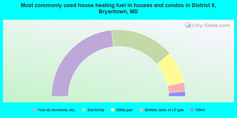
- 46.8%Fuel oil, kerosene, etc.
- 31.0%Electricity
- 15.5%Utility gas
- 4.4%Bottled, tank, or LP gas
- 2.2%Wood
- 0.2%Other fuel
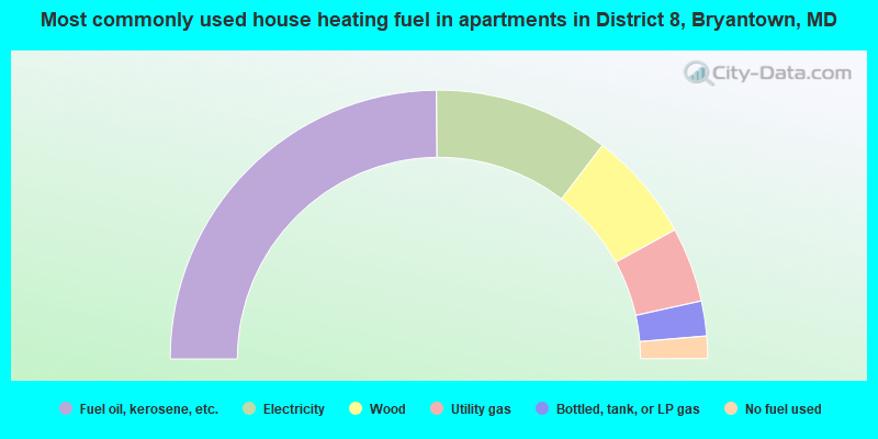
- 49.7%Fuel oil, kerosene, etc.
- 21.1%Electricity
- 13.3%Wood
- 9.0%Utility gas
- 4.2%Bottled, tank, or LP gas
- 2.7%No fuel used
District 8, Bryantown compared to Maryland state average:
- Unemployed percentage significantly below state average.
- Hispanic race population percentage significantly below state average.
- Median age above state average.
- Foreign-born population percentage significantly below state average.
- Renting percentage significantly below state average.
- Length of stay since moving in significantly above state average.
- Number of rooms per house significantly below state average.
- House age significantly below state average.
- Percentage of population with a bachelor's degree or higher below state average.
District 8, Bryantown on our top lists:
- #7 on the list of "Top 101 cities with largest percentage of females in occupations: computer specialists (population 5,000+)"
- #10 on the list of "Top 101 cities with largest percentage of females in occupations: secretaries and administrative assistants (population 5,000+)"
- #18 on the list of "Top 101 cities with largest percentage of males in industries: book stores and news dealers (population 5,000+)"
- #19 on the list of "Top 100 low-educated but high-earning cities"
- #27 on the list of "Top 101 cities with largest percentage of females in occupations: other construction workers and helpers (population 5,000+)"
- #33 on the list of "Top 101 cities with largest percentage of females in occupations: business operations specialists (population 5,000+)"
- #33 on the list of "Top 101 cities with largest percentage of females in occupations: mathematical science occupations (population 5,000+)"
- #39 on the list of "Top 101 cities with largest percentage of males in occupations: drafters, engineering, and mapping technicians (population 5,000+)"
- #54 on the list of "Top 101 cities with largest percentage of females in industries: public administration (population 5,000+)"
- #74 on the list of "Top 101 cities with the most residents born in Other Northern America (population 500+)"
- #84 on the list of "Top 101 cities with largest percentage of males in industries: religious, grantmaking, civic, professional, and similar organizations (population 5,000+)"
- #97 on the list of "Top 101 cities with the largest percentage of one, detached housing units in structures (2,000+ housing units)"
- #85 on the list of "Top 101 counties with the highest percentage of residents relocating from foreign countries between 2010 and 2011 (pop. 50,000+)"
- #86 on the list of "Top 101 counties with highest percentage of residents voting for Obama (Democrat) in the 2012 Presidential Election (pop. 50,000+)"
- #90 on the list of "Top 101 counties with the best general health status score of residents (1-5), 3 years of data"
- #92 on the list of "Top 101 counties with the highest percentage of residents that visited a dentist within the past year"
- #96 on the list of "Top 101 counties with the lowest number of deaths per 1000 residents 2007-2013 (pop. 50,000+)"