Dunstable, Massachusetts
Submit your own pictures of this town and show them to the world
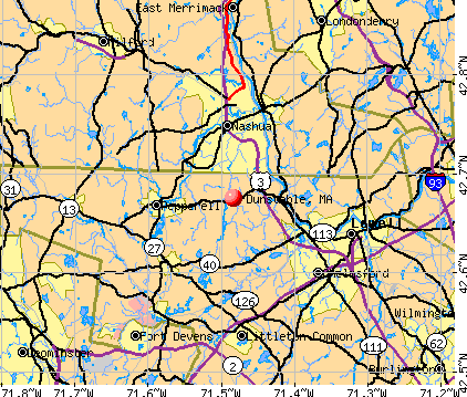
- OSM Map
- General Map
- Google Map
- MSN Map
Population change since 2000: +12.4%
 |
| Males: 1,598 | |
| Females: 1,581 |
| Median resident age: | 42.9 years |
| Massachusetts median age: | 39.2 years |
Zip codes: 01827.
| Dunstable: | $169,218 |
| MA: | $94,488 |
Estimated per capita income in 2022: $63,548 (it was $30,608 in 2000)
Dunstable town income, earnings, and wages data
Estimated median house or condo value in 2022: $767,399 (it was $271,500 in 2000)
| Dunstable: | $767,399 |
| MA: | $534,700 |
Mean prices in 2022: all housing units: $796,617; detached houses: $834,667; townhouses or other attached units: $772,440; in 2-unit structures: $786,250; in 3-to-4-unit structures: $655,835; in 5-or-more-unit structures: $590,321; mobile homes: $144,935
Detailed information about poverty and poor residents in Dunstable, MA


- 2,99394.1%White alone
- 973.1%Asian alone
- 441.4%Hispanic
- 321.0%Two or more races
- 60.2%Black alone
- 40.1%Native Hawaiian and Other
Pacific Islander alone - 30.09%American Indian alone
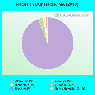
Races in Dunstable detailed stats: ancestries, foreign born residents, place of birth
According to our research of Massachusetts and other state lists, there was 1 registered sex offender living in Dunstable, Massachusetts as of May 17, 2024.
The ratio of all residents to sex offenders in Dunstable is 3,179 to 1.
The ratio of registered sex offenders to all residents in this city is lower than the state average.
Type |
2012 |
2013 |
2014 |
2015 |
2016 |
2017 |
2018 |
2019 |
2020 |
2021 |
2022 |
|---|---|---|---|---|---|---|---|---|---|---|---|
| Murders (per 100,000) | 0 (0.0) | 0 (0.0) | 0 (0.0) | 0 (0.0) | 0 (0.0) | 0 (0.0) | 0 (0.0) | 0 (0.0) | 0 (0.0) | 0 (0.0) | 0 (0.0) |
| Rapes (per 100,000) | 1 (30.8) | 1 (29.9) | 0 (0.0) | 0 (0.0) | 0 (0.0) | 0 (0.0) | 1 (29.4) | 0 (0.0) | 2 (58.7) | 0 (0.0) | 0 (0.0) |
| Robberies (per 100,000) | 0 (0.0) | 1 (29.9) | 1 (29.4) | 0 (0.0) | 0 (0.0) | 1 (29.5) | 0 (0.0) | 0 (0.0) | 0 (0.0) | 0 (0.0) | 0 (0.0) |
| Assaults (per 100,000) | 0 (0.0) | 5 (149.3) | 2 (58.9) | 4 (116.2) | 4 (115.2) | 1 (29.5) | 3 (88.1) | 3 (88.1) | 2 (58.7) | 1 (29.0) | 4 (120.0) |
| Burglaries (per 100,000) | 0 (0.0) | 6 (179.1) | 4 (117.8) | 2 (58.1) | 4 (115.2) | 5 (147.5) | 6 (176.1) | 3 (88.1) | 3 (88.0) | 0 (0.0) | 0 (0.0) |
| Thefts (per 100,000) | 2 (61.7) | 15 (447.8) | 25 (736.2) | 18 (523.0) | 12 (345.7) | 13 (383.6) | 11 (322.9) | 3 (88.1) | 14 (410.6) | 4 (115.8) | 2 (60.0) |
| Auto thefts (per 100,000) | 0 (0.0) | 1 (29.9) | 2 (58.9) | 0 (0.0) | 0 (0.0) | 2 (59.0) | 1 (29.4) | 1 (29.4) | 0 (0.0) | 0 (0.0) | 2 (60.0) |
| Arson (per 100,000) | 0 (0.0) | 0 (0.0) | 0 (0.0) | 0 (0.0) | 2 (57.6) | 0 (0.0) | 0 (0.0) | 0 (0.0) | 2 (58.7) | 1 (29.0) | 0 (0.0) |
| City-Data.com crime index | 27.1 | 95.5 | 63.0 | 48.2 | 44.9 | 45.1 | 68.7 | 29.7 | 81.2 | 10.4 | 31.2 |
The City-Data.com crime index weighs serious crimes and violent crimes more heavily. Higher means more crime, U.S. average is 246.1. It adjusts for the number of visitors and daily workers commuting into cities.
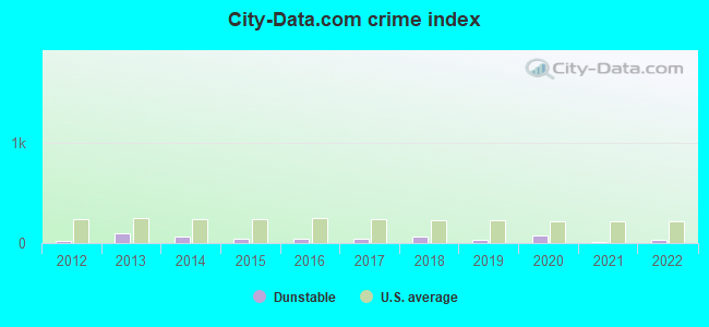
Crime rate in Dunstable detailed stats: murders, rapes, robberies, assaults, burglaries, thefts, arson
Full-time law enforcement employees in 2021, including police officers: 10 (9 officers - 9 male; 0 female).
| Officers per 1,000 residents here: | 2.61 |
| Massachusetts average: | 2.53 |
 Recent articles from our blog. Our writers, many of them Ph.D. graduates or candidates, create easy-to-read articles on a wide variety of topics.

 | Home Prices By Town for 2022 (190 replies) |
| Acton or…? (77 replies) |
| Big MA Ancestry Data Thread by Town (31 replies) |
| Dunstable (2 replies) |
| Can you please recommend towns closer to Chelmsford to buy a property for my friend? (30 replies) |
| Littleton or Westford (10 replies) |
Latest news from Dunstable, MA collected exclusively by city-data.com from local newspapers, TV, and radio stations
Ancestries: Irish (31.6%), English (16.6%), Italian (11.8%), French (10.4%), French Canadian (7.0%), Polish (5.5%).
Current Local Time: EST time zone
Incorporated in 1673
Elevation: 224 feet
Land area: 16.5 square miles.
Population density: 192 people per square mile (very low).
97 residents are foreign born (2.3% Europe, 0.5% Asia, 0.4% Latin America).
| This town: | 3.4% |
| Massachusetts: | 12.2% |
| Dunstable town: | 1.2% ($3,221) |
| Massachusetts: | 1.3% ($2,336) |
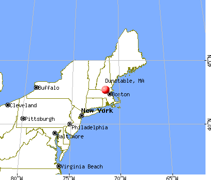
Nearest city with pop. 50,000+: Nashua, NH  (5.6 miles , pop. 86,605).
Nearest city with pop. 200,000+: Boston, MA (32.1 miles , pop. 589,141).
Nearest city with pop. 1,000,000+: Bronx, NY (175.7 miles , pop. 1,332,650).
Nearest cities:
), ), Latitude: 42.67 N, Longitude: 71.50 W

Single-family new house construction building permits:
- 2022: 12 buildings, average cost: $114,800
- 2021: 13 buildings, average cost: $114,800
- 2020: 10 buildings, average cost: $114,800
- 2019: 10 buildings, average cost: $114,800
- 2018: 9 buildings, average cost: $114,800
- 2017: 12 buildings, average cost: $114,800
- 2016: 13 buildings, average cost: $114,800
- 2015: 13 buildings, average cost: $114,800
- 2014: 12 buildings, average cost: $114,800
- 2013: 11 buildings, average cost: $114,800
- 2012: 8 buildings, average cost: $114,800
- 2011: 9 buildings, average cost: $114,800
- 2010: 12 buildings, average cost: $114,800
- 2009: 11 buildings, average cost: $114,800
- 2008: 12 buildings, average cost: $114,800
- 2007: 18 buildings, average cost: $114,800
- 2006: 24 buildings, average cost: $114,800
- 2005: 30 buildings, average cost: $114,800
- 2004: 29 buildings, average cost: $114,800
- 2003: 26 buildings, average cost: $114,800
- 2002: 27 buildings, average cost: $114,800
- 2001: 25 buildings, average cost: $114,800
- 2000: 29 buildings, average cost: $114,800
- 1999: 30 buildings, average cost: $114,800
- 1998: 29 buildings, average cost: $114,800
- 1997: 27 buildings, average cost: $114,900
| Here: | 2.7% |
| Massachusetts: | 3.5% |
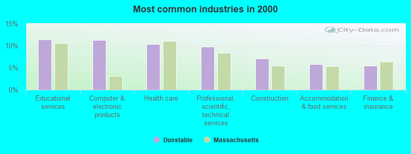
- Educational services (11.4%)
- Computer & electronic products (11.2%)
- Health care (10.3%)
- Professional, scientific, technical services (9.8%)
- Construction (7.1%)
- Accommodation & food services (5.9%)
- Finance & insurance (5.5%)
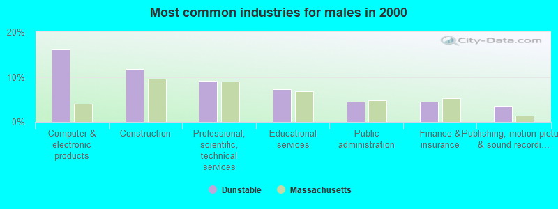
- Computer & electronic products (16.1%)
- Construction (11.7%)
- Professional, scientific, technical services (9.2%)
- Educational services (7.3%)
- Public administration (4.4%)
- Finance & insurance (4.4%)
- Publishing, motion picture & sound recording industries (3.6%)
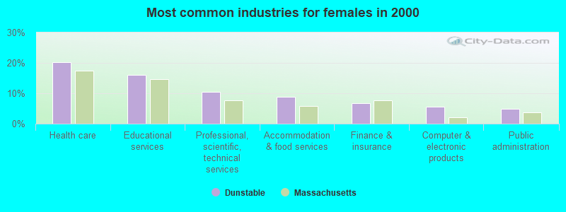
- Health care (20.2%)
- Educational services (16.0%)
- Professional, scientific, technical services (10.4%)
- Accommodation & food services (8.8%)
- Finance & insurance (6.7%)
- Computer & electronic products (5.6%)
- Public administration (4.9%)
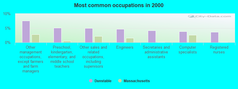
- Other management occupations, except farmers and farm managers (7.5%)
- Preschool, kindergarten, elementary, and middle school teachers (5.1%)
- Other sales and related occupations, including supervisors (4.9%)
- Engineers (4.7%)
- Secretaries and administrative assistants (4.1%)
- Computer specialists (3.8%)
- Registered nurses (3.6%)
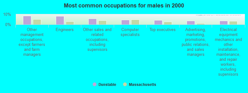
- Other management occupations, except farmers and farm managers (8.6%)
- Engineers (8.2%)
- Other sales and related occupations, including supervisors (5.6%)
- Computer specialists (4.5%)
- Top executives (4.3%)
- Advertising, marketing, promotions, public relations, and sales managers (3.7%)
- Electrical equipment mechanics and other installation, maintenance, and repair workers, including supervisors (3.7%)
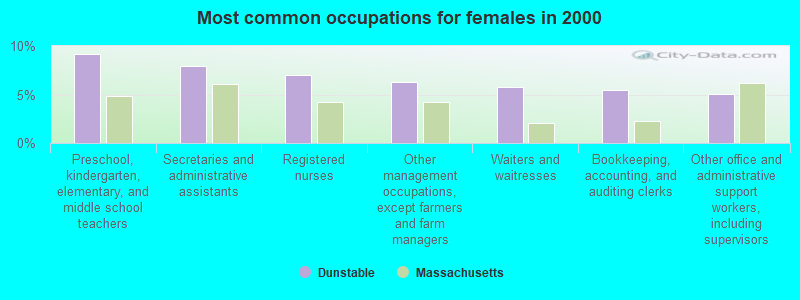
- Preschool, kindergarten, elementary, and middle school teachers (9.2%)
- Secretaries and administrative assistants (7.9%)
- Registered nurses (7.0%)
- Other management occupations, except farmers and farm managers (6.3%)
- Waiters and waitresses (5.7%)
- Bookkeeping, accounting, and auditing clerks (5.5%)
- Other office and administrative support workers, including supervisors (5.1%)
Average climate in Dunstable, Massachusetts
Based on data reported by over 4,000 weather stations


(lower is better)
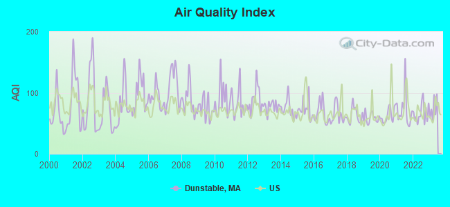
Air Quality Index (AQI) level in 2022 was 66.7. This is about average.
| City: | 66.7 |
| U.S.: | 72.6 |
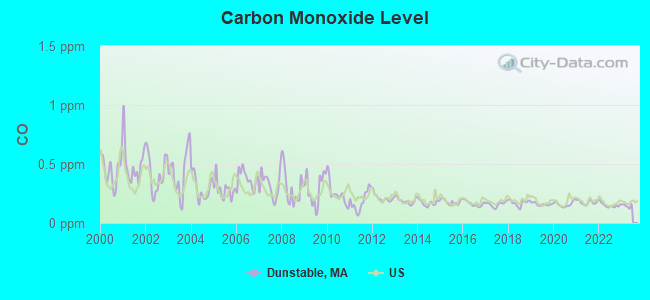
Carbon Monoxide (CO) [ppm] level in 2022 was 0.150. This is significantly better than average. Closest monitor was 6.0 miles away from the city center.
| City: | 0.150 |
| U.S.: | 0.251 |
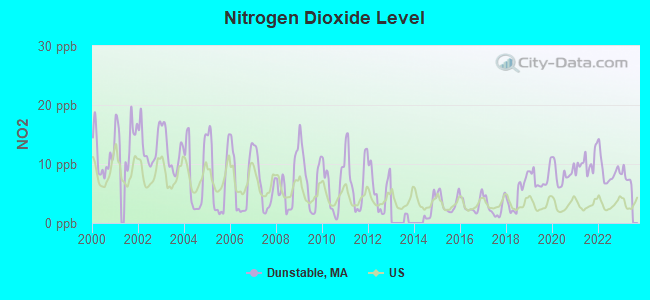
Nitrogen Dioxide (NO2) [ppb] level in 2022 was 8.76. This is significantly worse than average. Closest monitor was 3.4 miles away from the city center.
| City: | 8.76 |
| U.S.: | 5.11 |
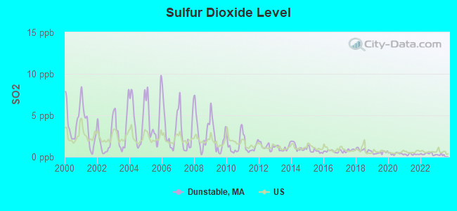
Sulfur Dioxide (SO2) [ppb] level in 2022 was 0.352. This is significantly better than average. Closest monitor was 3.7 miles away from the city center.
| City: | 0.352 |
| U.S.: | 1.515 |
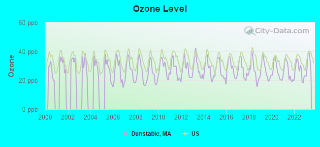
Ozone [ppb] level in 2022 was 26.7. This is better than average. Closest monitor was 3.4 miles away from the city center.
| City: | 26.7 |
| U.S.: | 33.3 |
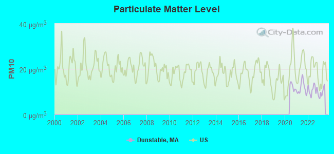
Particulate Matter (PM10) [µg/m3] level in 2022 was 10.6. This is significantly better than average. Closest monitor was 3.7 miles away from the city center.
| City: | 10.6 |
| U.S.: | 19.2 |
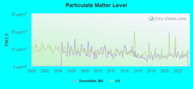
Particulate Matter (PM2.5) [µg/m3] level in 2022 was 5.95. This is better than average. Closest monitor was 3.7 miles away from the city center.
| City: | 5.95 |
| U.S.: | 8.11 |
Tornado activity:
Dunstable-area historical tornado activity is slightly above Massachusetts state average. It is 29% smaller than the overall U.S. average.
On 6/9/1953, a category F4 (max. wind speeds 207-260 mph) tornado 25.7 miles away from the Dunstable town center killed 90 people and injured 1228 people and caused between $50,000,000 and $500,000,000 in damages.
On 10/3/1970, a category F3 (max. wind speeds 158-206 mph) tornado 7.1 miles away from the town center killed one person and caused between $50,000 and $500,000 in damages.
Earthquake activity:
Dunstable-area historical earthquake activity is significantly above Massachusetts state average. It is 72% smaller than the overall U.S. average.On 10/7/1983 at 10:18:46, a magnitude 5.3 (5.1 MB, 5.3 LG, 5.1 ML, Class: Moderate, Intensity: VI - VII) earthquake occurred 168.1 miles away from the city center
On 4/20/2002 at 10:50:47, a magnitude 5.3 (5.3 ML, Depth: 3.0 mi) earthquake occurred 168.2 miles away from Dunstable center
On 1/19/1982 at 00:14:42, a magnitude 4.7 (4.5 MB, 4.7 MD, 4.5 LG, Class: Light, Intensity: IV - V) earthquake occurred 57.5 miles away from the city center
On 4/20/2002 at 10:50:47, a magnitude 5.2 (5.2 MB, 4.2 MS, 5.2 MW, 5.0 MW) earthquake occurred 167.6 miles away from Dunstable center
On 10/16/2012 at 23:12:25, a magnitude 4.7 (4.7 ML, Depth: 10.0 mi) earthquake occurred 77.0 miles away from the city center
On 8/22/1992 at 12:20:32, a magnitude 4.8 (4.8 MB, 3.8 MS, 4.7 LG, Depth: 6.2 mi) earthquake occurred 254.2 miles away from the city center
Magnitude types: regional Lg-wave magnitude (LG), body-wave magnitude (MB), duration magnitude (MD), local magnitude (ML), surface-wave magnitude (MS), moment magnitude (MW)
Natural disasters:
The number of natural disasters in Middlesex County (31) is a lot greater than the US average (15).Major Disasters (Presidential) Declared: 17
Emergencies Declared: 14
Causes of natural disasters: Floods: 12, Storms: 9, Hurricanes: 6, Snowstorms: 6, Winter Storms: 5, Blizzards: 2, Snows: 2, Explosion: 1, Heavy Rain: 1, Snowfall: 1, Water Main Break: 1, Wind: 1 (Note: some incidents may be assigned to more than one category).

Hospitals and medical centers near Dunstable:
- KINDRED TRANSITIONAL CARE AND REHABILITATION-GREENBR (Nursing Home, about 5 miles away; NASHUA, NH)
- FREEMAN NURSING HOME (Nursing Home, about 5 miles away; PEPPERELL, MA)
- PARK MANOR NURSING HOME (Nursing Home, about 5 miles away; PEPPERELL, MA)
- BEACON HOSPICE INC (Hospital, about 6 miles away; NASHUA, NH)
- COURVILLE AT NASHUA (Nursing Home, about 6 miles away; NASHUA, NH)
- ST JOSEPH HOSPITAL Acute Care Hospitals (about 6 miles away; NASHUA, NH)
- SEVEN HILLS PEDIATRIC CENTER (Nursing Home, about 6 miles away; GROTON, MA)
Colleges/universities with over 2000 students nearest to Dunstable:
- University of Massachusetts-Lowell (about 10 miles; Lowell, MA; Full-time enrollment: 12,341)
- Middlesex Community College (about 16 miles; Bedford, MA; FT enrollment: 6,040)
- Fitchburg State University (about 16 miles; Fitchburg, MA; FT enrollment: 5,010)
- Merrimack College (about 20 miles; North Andover, MA; FT enrollment: 2,734)
- Mount Washington College (about 21 miles; Manchester, NH; FT enrollment: 2,187)
- Saint Anselm College (about 22 miles; Manchester, NH; FT enrollment: 2,059)
- Bentley University (about 25 miles; Waltham, MA; FT enrollment: 5,229)
Public elementary/middle school in Dunstable:
- SWALLOW/UNION SCHOOL (Students: 316, Location: 522 MAIN STREET, Grades: KG-4)
Points of interest:
Notable locations in Dunstable: Camp Massapoag (A), Dunstable Fire Department (B), Dunstable Free Public Library (C), Dunstable Town Hall (D). Display/hide their locations on the map
Church in Dunstable: Dunstable Congregational Church (A). Display/hide its location on the map
Cemeteries: Blood Cemetery (1), Central Cemetery (2), Mount Hermon Cemetery (3). Display/hide their locations on the map
Lakes, reservoirs, and swamps: Hawk Pond (A), Lower Massapoag Pond (B), Massapoag Pond (C), Massapoag Ponds (D), Hauk Swamp (E). Display/hide their locations on the map
Streams, rivers, and creeks: Unkety Brook (A), Black Brook (B), Hauk Brook (C), Joint Grass Brook (D). Display/hide their locations on the map
Park in Dunstable: Town Common (1). Display/hide its location on the map
Birthplace of: George E. Davis (Medal of Honor) - Army Medal of Honor recipient.
Drinking water stations with addresses in Dunstable and their reported violations in the past:
DUNSTABLE WATER DEPARTMENT (Population served: 598, Groundwater):Past monitoring violations:YMCA CAMP MASSAPOAG (Population served: 150, Groundwater):
- Follow-up Or Routine LCR Tap M/R - In JUL-01-2013, Contaminant: Lead and Copper Rule. Follow-up actions: St AO (w/o penalty) issued (NOV-26-2013)
- 3 regular monitoring violations
Past monitoring violations:
- 2 routine major monitoring violations
- 3 minor monitoring violations
| This town: | 3.0 people |
| Massachusetts: | 2.5 people |
| This town: | 83.5% |
| Whole state: | 63.0% |
| This town: | 4.0% |
| Whole state: | 7.0% |
Likely homosexual households (counted as self-reported same-sex unmarried-partner households)
- Lesbian couples: 0.9% of all households
- Gay men: 0.3% of all households
| This town: | 1.9% |
| Whole state: | 9.3% |
| This town: | 0.5% |
| Whole state: | 4.4% |
For population 15 years and over in Dunstable:
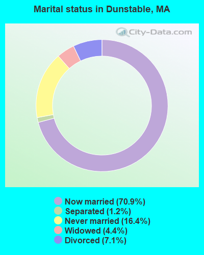
- Never married: 16.4%
- Now married: 70.9%
- Separated: 1.2%
- Widowed: 4.4%
- Divorced: 7.1%
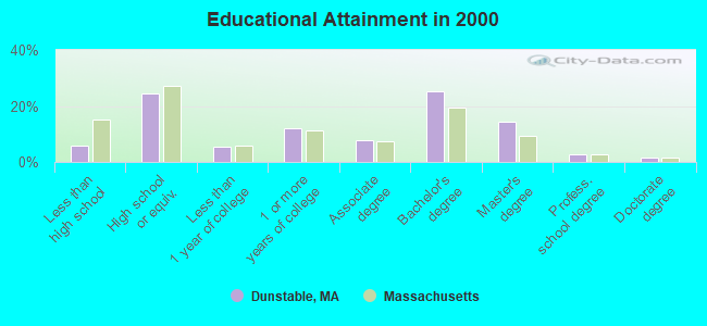
For population 25 years and over in Dunstable:
- High school or higher: 94.2%
- Bachelor's degree or higher: 44.2%
- Graduate or professional degree: 18.9%
- Unemployed: 1.9%
- Mean travel time to work (commute): 32.3 minutes
| Here: | 9.7 |
| Massachusetts average: | 13.1 |


Graphs represent county-level data. Detailed 2008 Election Results
Religion statistics for Dunstable, MA (based on Middlesex County data)


| Religion | Adherents | Congregations |
|---|---|---|
| Catholic | 718,209 | 107 |
| Mainline Protestant | 70,053 | 269 |
| Other | 68,480 | 199 |
| Evangelical Protestant | 41,270 | 304 |
| Orthodox | 23,641 | 28 |
| Black Protestant | 2,276 | 8 |
| None | 579,156 | - |
Food Environment Statistics:
| This county: | 1.71 / 10,000 pop. |
| Massachusetts: | 1.98 / 10,000 pop. |
| Here: | 0.03 / 10,000 pop. |
| Massachusetts: | 0.05 / 10,000 pop. |
| Here: | 2.14 / 10,000 pop. |
| State: | 2.22 / 10,000 pop. |
| This county: | 1.38 / 10,000 pop. |
| State: | 1.77 / 10,000 pop. |
| This county: | 7.84 / 10,000 pop. |
| Massachusetts: | 8.76 / 10,000 pop. |
| Middlesex County: | 7.8% |
| Massachusetts: | 8.1% |
| This county: | 21.5% |
| Massachusetts: | 22.5% |
| This county: | 18.0% |
| Massachusetts: | 16.5% |
6.91% of this county's 2021 resident taxpayers lived in other counties in 2020 ($102,955 average adjusted gross income)
| Here: | 6.91% |
| Massachusetts average: | 6.35% |
0.01% of residents moved from foreign countries ($137 average AGI)
Middlesex County: 0.01% Massachusetts average: 0.01%
Top counties from which taxpayers relocated into this county between 2020 and 2021:
| from Suffolk County, MA | |
| from Essex County, MA | |
| from Norfolk County, MA |
8.22% of this county's 2020 resident taxpayers moved to other counties in 2021 ($123,369 average adjusted gross income)
| Here: | 8.22% |
| Massachusetts average: | 7.18% |
0.01% of residents moved to foreign countries ($124 average AGI)
Middlesex County: 0.01% Massachusetts average: 0.02%
Top counties to which taxpayers relocated from this county between 2020 and 2021:
| to Suffolk County, MA | |
| to Essex County, MA | |
| to Worcester County, MA |
Businesses in Dunstable, MA
- Dunkin Donuts: 1
- YMCA: 1
Strongest AM radio stations in Dunstable:
- WRKO (680 AM; 50 kW; BOSTON, MA; Owner: ENTERCOM BOSTON LICENSE, LLC)
- WSMN (1590 AM; 5 kW; NASHUA, NH; Owner: 1590 BROADCASTING CORP.)
- WCAP (980 AM; 5 kW; LOWELL, MA; Owner: NORTHEAST RADIO, INC.)
- WEEI (850 AM; 50 kW; BOSTON, MA; Owner: ENTERCOM BOSTON LICENSE, LLC)
- WKOX (1200 AM; 50 kW; FRAMINGHAM, MA; Owner: CAPSTAR TX LIMITED PARTNERSHIP)
- WWZN (1510 AM; 50 kW; BOSTON, MA; Owner: ROSE CITY RADIO CORPORATION)
- WBIX (1060 AM; 40 kW; NATICK, MA; Owner: LANGER BROADCASTING CORPORATION)
- WCRN (830 AM; 50 kW; WORCESTER, MA; Owner: CARTER BROADCASTING CORPORATION)
- WAMG (890 AM; 25 kW; DEDHAM, MA; Owner: MEGA COMMUNICATIONS OF DEDHAM LICENSEE, LLC)
- WRCA (1330 AM; 25 kW; WALTHAM, MA; Owner: WRCA LICENSE, LLC)
- WBZ (1030 AM; 50 kW; BOSTON, MA; Owner: INFINITY BROADCASTING OPERATIONS, INC.)
- WSNH (900 AM; 1 kW; NASHUA, NH; Owner: ANASTOS MEDIA GROUP, INC.)
- WDER (1320 AM; 10 kW; DERRY, NH; Owner: BLOUNT COMMUNICATIONS, INC. OF NH)
Strongest FM radio stations in Dunstable:
- WHOB (106.3 FM; NASHUA, NH; Owner: TELE-MEDIA COMPANY OF NEW HAMPSHIRE, L.L.C.)
- WFEX (92.1 FM; PETERBOROUGH, NH; Owner: FNX BROADCASTING OF NEW HAMPSHIRE LLC)
- WKLB-FM (99.5 FM; LOWELL, MA; Owner: GREATER BOSTON RADIO, INC.)
- WGIR-FM (101.1 FM; MANCHESTER, NH; Owner: CAPSTAR TX LIMITED PARTNERSHIP)
- W227AM (93.3 FM; ANDOVER, MA; Owner: GREATER BOSTON RADIO, INC.)
- WQLL (96.5 FM; BEDFORD, NH; Owner: SAGA COMMUNICATIONS OF NEW ENGLAND, LLC)
- WLMW (90.7 FM; MANCHESTER, NH; Owner: KNOWLEDGE FOR LIFE)
- WZID (95.7 FM; MANCHESTER, NH; Owner: SAGA COMMUNICATIONS OF NEW ENGLAND, LLC)
- WBMX (98.5 FM; BOSTON, MA; Owner: INFINITY RADIO OPERATIONS INC.)
- WJMN (94.5 FM; BOSTON, MA; Owner: AMFM RADIO LICENSES, L.L.C.)
- WCRB (102.5 FM; WALTHAM, MA; Owner: CHARLES RIVER BROADCASTING WCRB LICE)
- WTKK (96.9 FM; BOSTON, MA; Owner: GREATER BOSTON RADIO, INC.)
- WROR-FM (105.7 FM; FRAMINGHAM, MA; Owner: GREATER BOSTON RADIO, INC.)
- WBOS (92.9 FM; BROOKLINE, MA; Owner: GREATER BOSTON RADIO, INC.)
- WXLO (104.5 FM; FITCHBURG, MA; Owner: CITADEL BROADCASTING COMPANY)
- WXKS-FM (107.9 FM; MEDFORD, MA; Owner: AMFM RADIO LICENSES, L.L.C.)
- WGBH (89.7 FM; BOSTON, MA; Owner: WGBH EDUCATIONAL FOUNDATION)
- WMJX (106.7 FM; BOSTON, MA; Owner: GREATER BOSTON RADIO, INC.)
- WXRV (92.5 FM; HAVERHILL, MA; Owner: BEANPOT BROADCASTING CORP.)
- WBUR-FM (90.9 FM; BOSTON, MA; Owner: TRUSTEES OF BOSTON UNIVERSITY)
TV broadcast stations around Dunstable:
- WNDS (Channel 50; DERRY, NH; Owner: CTV OF DERRY, INC)
- WUTF (Channel 66; MARLBOROUGH, MA; Owner: TELEFUTURA BOSTON LLC)
- WCVB-TV (Channel 5; BOSTON, MA; Owner: WCVB HEARST-ARGYLE TV, INC.)
- WFXZ-CA (Channel 24; BOSTON, MA; Owner: BOSTON BROADCASTING CORP.)
- WGBH-TV (Channel 2; BOSTON, MA; Owner: WGBH EDUCATIONAL FOUNDATION)
- WUNI (Channel 27; WORCESTER, MA; Owner: ENTRAVISION HOLDINGS, LLC)
- WHDH-TV (Channel 7; BOSTON, MA; Owner: WHDH-TV)
- WMFP (Channel 62; LAWRENCE, MA; Owner: WSAH LICENSE, INC.)
- WBZ-TV (Channel 4; BOSTON, MA; Owner: VIACOM INC.)
- WGBX-TV (Channel 44; BOSTON, MA; Owner: WGBH EDUCATIONAL FOUNDATION)
- WSBK-TV (Channel 38; BOSTON, MA; Owner: VIACOM INC.)
- WLVI-TV (Channel 56; CAMBRIDGE, MA; Owner: WLVI, INC.)
- WFXT (Channel 25; BOSTON, MA; Owner: FOX TELEVISION STATIONS INC.)
- W33AK (Channel 33; NASHUA, NH; Owner: CENTER B/CING CORPORATION OF NEW HAMPSHIRE)
- WYCN-LP (Channel 13; NASHUA, NH; Owner: CENTER BROADCASTING CORP. OF NEW HAMPSHIRE)
- WBPX (Channel 68; BOSTON, MA; Owner: PAXSON BOSTON-68 LICENSE, INC.)
- W40BO (Channel 40; BOSTON, MA; Owner: PAXSON COMMUNICATIONS LPTV, INC.)
- WTMU-LP (Channel 32; BOSTON, MA; Owner: ZGS BOSTON, INC.)
- WCEA-LP (Channel 58; BOSTON, MA; Owner: CHANNEL 19 TV CORPORATION)
- WHDN-LP (Channel 26; BOSTON, MA; Owner: GUENTER MARKSTEINER)
Medal of Honor Recipients
Medal of Honor Recipient born in Dunstable: George E. Davis.
- National Bridge Inventory (NBI) Statistics
- 1Number of bridges
- 3ft / 0.7mTotal length
- 2,433Total average daily traffic
- 145Total average daily truck traffic
FCC Registered Antenna Towers:
3- Dan Menser, 583 Pleasant Street (Lat: 42.674194 Lon: -71.522472), Type: 38.7, Overall height: 38.7 m, Registrant: Voicestream Wireless Corp., Dan.Menser@voicestream.Com, , Belle-vue, Phone: (425) 378-4000
- Sean O'Malley, 583 Pleasant Street (Lat: 42.674194 Lon: -71.522472), Type: 38.7, Overall height: 38.7 m, Registrant: American Towers, Inc., Bosto-n, Phone: (617) 585-7600
- Sean O'Malley, 583 Pleasant Street (Lat: 42.674194 Lon: -71.522472), Type: 38.7, Overall height: 38.7 m, Registrant: American Towers, Inc., Bosto-n, Phone: (617) 585-7600
FCC Registered Broadcast Land Mobile Towers:
3- 87 Pleasant St (Lat: 42.669278 Lon: -71.486083), Type: Tank, Structure height: 15.2 m, Overall height: 15.5 m, Call Sign: KCF309,
Assigned Frequencies: 453.337 MHz, Grant Date: 07/15/2021, Expiration Date: 09/18/2031, Registrant: Modular Communications, 932 Fitchburg Rd, Greenville, NH 03048, Phone: (603) 217-2346, Fax: (603) 386-6344, Email:
- George Bacon Home Pleasant St (Lat: 42.704806 Lon: -71.478667), Call Sign: KJS918,
Assigned Frequencies: 33.6600 MHz, Grant Date: 08/18/2005, Expiration Date: 10/02/2015, Cancellation Date: 12/05/2015, Registrant: Beltronics, Inc., 19 Proctor Hill Rd, Hollis, NH 03049, Phone: (603) 465-2422, Fax: (603) 465-3320, Email:
- Lat: 42.671472 Lon: -71.478667, Call Sign: WQDN213,
Assigned Frequencies: 453.437 MHz, 458.437 MHz, Grant Date: 10/05/2005, Expiration Date: 04/03/2006, Cancellation Date: 06/03/2006, Certifier: George Bacon, Registrant: Cara Enterprises Inc, Salt Lake City, UT 84117-0503, Phone: (801) 278-9728, Fax: (801) 278-7239, Email:
FCC Registered Amateur Radio Licenses:
16 (See the full list of FCC Registered Amateur Radio Licenses in Dunstable)FAA Registered Aircraft:
1- Aircraft: PIPER PA-24-260 (Category: Land, Seats: 4, Weight: Up to 12,499 Pounds, Speed: 135 mph), Engine: LYCOMING TI0-540 SER (310 HP) (Reciprocating)
N-Number: 9391P, N9391P, N-9391P, Serial Number: 24-4893, Airworthiness Date: 09/11/1969, Certificate Issue Date: 11/18/2019
Registrant (Individual): William G Psaledakis, Po Box 130, Dunstable, MA 01827
Deregistered: Cancel Date: 05/22/2013
2004 - 2018 National Fire Incident Reporting System (NFIRS) incidents
- Fire incident types reported to NFIRS in Dunstable, MA
- 6947.6%Outside Fires
- 6142.1%Structure Fires
- 117.6%Mobile Property/Vehicle Fires
- 42.8%Other
 Based on the data from the years 2004 - 2018 the average number of fire incidents per year is 10. The highest number of fires - 26 took place in 2010, and the least - 0 in 2005. The data has an increasing trend.
 When looking into fire subcategories, the most reports belonged to: Outside Fires (47.6%), and Structure Fires (42.1%).
- 61.8%Fuel oil, kerosene, etc.
- 27.3%Utility gas
- 4.6%Electricity
- 3.9%Wood
- 2.3%Bottled, tank, or LP gas
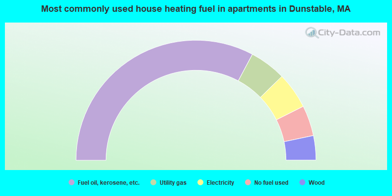
- 65.6%Fuel oil, kerosene, etc.
- 9.8%Utility gas
- 9.8%Electricity
- 8.2%No fuel used
- 6.6%Wood
Dunstable compared to Massachusetts state average:
- Median household income above state average.
- Unemployed percentage significantly below state average.
- Black race population percentage significantly below state average.
- Hispanic race population percentage significantly below state average.
- Foreign-born population percentage significantly below state average.
- Renting percentage significantly below state average.
- Length of stay since moving in significantly above state average.
- Number of rooms per house significantly below state average.
- House age significantly below state average.

|
|
Total of 173 patent applications in 2008-2024.