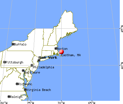
Eastham, Massachusetts
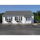
Eastham: eastham post office

Eastham: Eastham Windmill
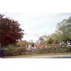
Eastham: Pottery Fair at the Eastham Windmill
- add
your
Submit your own pictures of this town and show them to the world
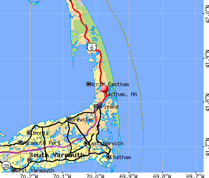
- OSM Map
- General Map
- Google Map
- MSN Map
Population change since 2000: -9.1%
 |
| Males: 2,307 | |
| Females: 2,649 |
| Median resident age: | 56.6 years |
| Massachusetts median age: | 39.2 years |
Zip codes: 02642.
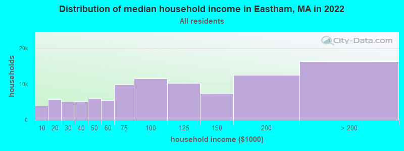
| Eastham: | $84,839 |
| MA: | $94,488 |
Estimated per capita income in 2022: $58,755 (it was $24,642 in 2000)
Eastham town income, earnings, and wages data
Estimated median house or condo value in 2022: $683,820 (it was $192,900 in 2000)
| Eastham: | $683,820 |
| MA: | $534,700 |
Mean prices in 2022: all housing units: $623,757; detached houses: $648,447; townhouses or other attached units: $490,502; in 2-unit structures: $577,155; in 3-to-4-unit structures: $445,551; in 5-or-more-unit structures: $351,307; mobile homes: $108,058
Detailed information about poverty and poor residents in Eastham, MA


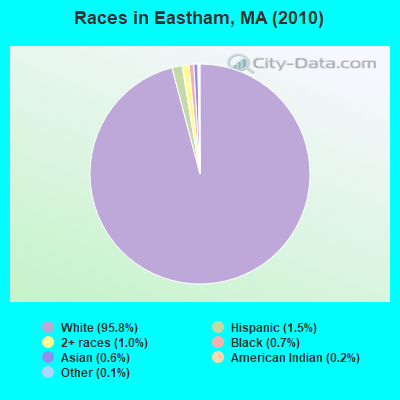
- 4,75095.8%White alone
- 751.5%Hispanic
- 501.0%Two or more races
- 340.7%Black alone
- 280.6%Asian alone
- 120.2%American Indian alone
- 70.1%Other race alone
Races in Eastham detailed stats: ancestries, foreign born residents, place of birth
According to our research of Massachusetts and other state lists, there were 3 registered sex offenders living in Eastham, Massachusetts as of May 19, 2024.
The ratio of all residents to sex offenders in Eastham is 1,652 to 1.
The ratio of registered sex offenders to all residents in this city is near the state average.
Type |
2009 |
2010 |
2011 |
2012 |
2013 |
2014 |
2015 |
2016 |
2017 |
2018 |
2019 |
2020 |
2021 |
2022 |
|---|---|---|---|---|---|---|---|---|---|---|---|---|---|---|
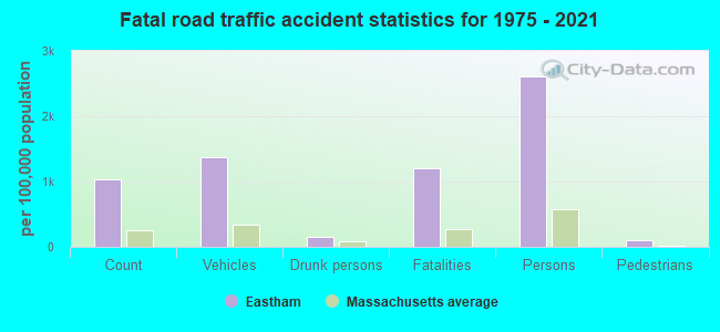
| Murders (per 100,000) | 0 (0.0) | 0 (0.0) | 0 (0.0) | 0 (0.0) | 0 (0.0) | 0 (0.0) | 0 (0.0) | 0 (0.0) | 0 (0.0) | 0 (0.0) | 0 (0.0) | 0 (0.0) | 0 (0.0) | 0 (0.0) |
| Rapes (per 100,000) | 0 (0.0) | 2 (40.4) | 2 (40.1) | 1 (20.0) | 1 (20.2) | 0 (0.0) | 2 (40.6) | 1 (20.5) | 1 (20.4) | 3 (61.6) | 2 (41.5) | 1 (20.5) | 2 (40.5) | 2 (33.7) |
| Robberies (per 100,000) | 1 (18.3) | 0 (0.0) | 2 (40.1) | 0 (0.0) | 0 (0.0) | 1 (20.2) | 0 (0.0) | 1 (20.5) | 1 (20.4) | 1 (20.5) | 0 (0.0) | 0 (0.0) | 0 (0.0) | 0 (0.0) |
| Assaults (per 100,000) | 6 (109.8) | 4 (80.7) | 13 (260.7) | 7 (140.1) | 11 (222.0) | 13 (263.2) | 18 (365.6) | 7 (143.3) | 9 (183.7) | 6 (123.2) | 3 (62.2) | 10 (205.2) | 12 (243.1) | 6 (101.0) |
| Burglaries (per 100,000) | 31 (567.3) | 7 (141.2) | 36 (722.0) | 24 (480.3) | 16 (322.8) | 16 (323.9) | 7 (142.2) | 8 (163.7) | 4 (81.6) | 8 (164.2) | 2 (41.5) | 3 (61.6) | 5 (101.3) | 5 (84.2) |
| Thefts (per 100,000) | 70 (1,281) | 66 (1,332) | 117 (2,347) | 99 (1,981) | 82 (1,655) | 67 (1,356) | 55 (1,117) | 46 (941.5) | 46 (939.0) | 57 (1,170) | 35 (725.7) | 17 (348.8) | 60 (1,215) | 29 (488.3) |
| Auto thefts (per 100,000) | 3 (54.9) | 0 (0.0) | 3 (60.2) | 4 (80.0) | 2 (40.4) | 5 (101.2) | 0 (0.0) | 2 (40.9) | 1 (20.4) | 1 (20.5) | 1 (20.7) | 1 (20.5) | 3 (60.8) | 0 (0.0) |
| Arson (per 100,000) | 0 (0.0) | 1 (20.2) | 0 (0.0) | 0 (0.0) | 1 (20.2) | 1 (20.2) | 0 (0.0) | 0 (0.0) | 0 (0.0) | 0 (0.0) | 0 (0.0) | 0 (0.0) | 0 (0.0) | 0 (0.0) |
| City-Data.com crime index | 122.8 | 111.6 | 245.5 | 163.3 | 152.5 | 143.7 | 160.3 | 103.6 | 104.1 | 140.0 | 79.2 | 77.3 | 141.6 | 72.6 |
The City-Data.com crime index weighs serious crimes and violent crimes more heavily. Higher means more crime, U.S. average is 246.1. It adjusts for the number of visitors and daily workers commuting into cities.
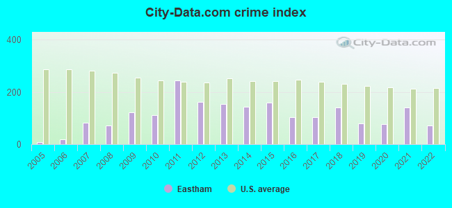
Crime rate in Eastham detailed stats: murders, rapes, robberies, assaults, burglaries, thefts, arson
Full-time law enforcement employees in 2021, including police officers: 22 (17 officers - 14 male; 3 female).
| Officers per 1,000 residents here: | 3.44 |
| Massachusetts average: | 2.53 |
 Recent articles from our blog. Our writers, many of them Ph.D. graduates or candidates, create easy-to-read articles on a wide variety of topics.

 | 2024 Real Estate Observations (892 replies) |
| "Migrants" living in hotels in MA---What is the endgame or is there one at all? (1049 replies) |
| 2023 Real Estate Observations (5278 replies) |
| Big MA Ancestry Data Thread by Town (31 replies) |
| Best Cape Cod Towns Vacation (23 replies) |
| Favorite Massachusetts Street Views (35 replies) |
Latest news from Eastham, MA collected exclusively by city-data.com from local newspapers, TV, and radio stations
Eastham, MA City Guides:
Ancestries: English (27.5%), Irish (23.8%), German (13.5%), Italian (12.5%), French (7.8%), United States (5.5%).
Current Local Time: EST time zone
Incorporated in 1646
Elevation: 48 feet
Land area: 14.0 square miles.
Population density: 354 people per square mile (very low).
207 residents are foreign born (2.9% Europe, 0.5% North America).
| This town: | 3.8% |
| Massachusetts: | 12.2% |
| Eastham town: | 0.9% ($1,693) |
| Massachusetts: | 1.3% ($2,336) |
Nearest city with pop. 50,000+: New Bedford, MA  (50.7 miles , pop. 93,768).
Nearest city with pop. 200,000+: Boston, MA (65.8 miles , pop. 589,141).
Nearest city with pop. 1,000,000+: Bronx, NY (213.3 miles , pop. 1,332,650).
Nearest cities:
), ), Latitude: 41.84 N, Longitude: 69.98 W

Eastham tourist attractions:
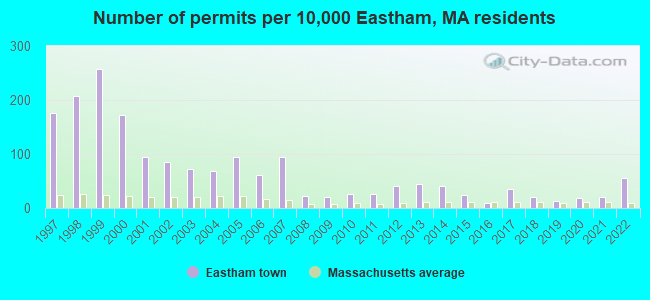
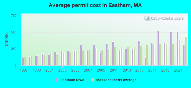
Single-family new house construction building permits:
- 2022: 30 buildings, average cost: $314,600
- 2021: 11 buildings, average cost: $512,900
- 2020: 10 buildings, average cost: $512,900
- 2019: 7 buildings, average cost: $338,600
- 2018: 11 buildings, average cost: $522,200
- 2017: 19 buildings, average cost: $335,200
- 2016: 5 buildings, average cost: $117,900
- 2015: 13 buildings, average cost: $376,400
- 2014: 22 buildings, average cost: $253,600
- 2013: 24 buildings, average cost: $245,800
- 2012: 22 buildings, average cost: $230,000
- 2011: 14 buildings, average cost: $364,100
- 2010: 14 buildings, average cost: $330,100
- 2009: 11 buildings, average cost: $197,500
- 2008: 12 buildings, average cost: $316,300
- 2007: 52 buildings, average cost: $228,100
- 2006: 33 buildings, average cost: $312,100
- 2005: 52 buildings, average cost: $224,100
- 2004: 37 buildings, average cost: $219,100
- 2003: 40 buildings, average cost: $222,400
- 2002: 47 buildings, average cost: $208,300
- 2001: 52 buildings, average cost: $167,900
- 2000: 94 buildings, average cost: $182,600
- 1999: 140 buildings, average cost: $144,900
- 1998: 113 buildings, average cost: $136,000
- 1997: 96 buildings, average cost: $123,300
| Here: | 6.7% |
| Massachusetts: | 3.5% |

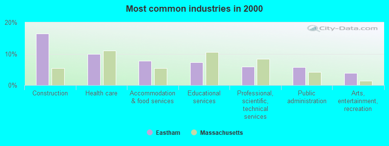
- Construction (16.4%)
- Health care (9.9%)
- Accommodation & food services (7.8%)
- Educational services (7.2%)
- Professional, scientific, technical services (5.9%)
- Public administration (5.8%)
- Arts, entertainment, recreation (3.9%)
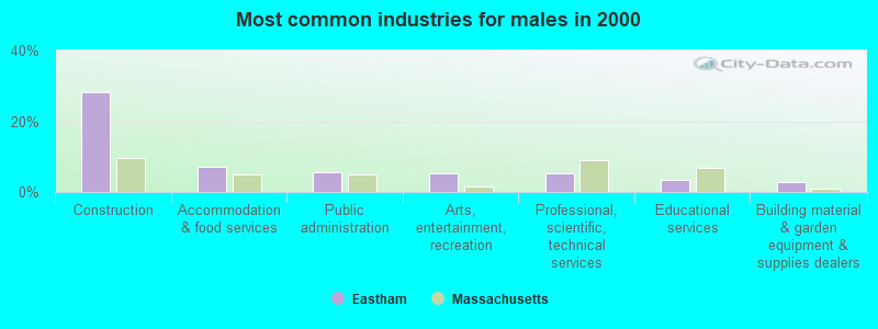
- Construction (28.2%)
- Accommodation & food services (7.0%)
- Public administration (5.5%)
- Arts, entertainment, recreation (5.4%)
- Professional, scientific, technical services (5.4%)
- Educational services (3.3%)
- Building material & garden equipment & supplies dealers (2.9%)
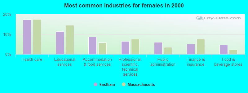
- Health care (17.4%)
- Educational services (11.5%)
- Accommodation & food services (8.6%)
- Professional, scientific, technical services (6.5%)
- Public administration (6.0%)
- Finance & insurance (5.1%)
- Food & beverage stores (4.8%)
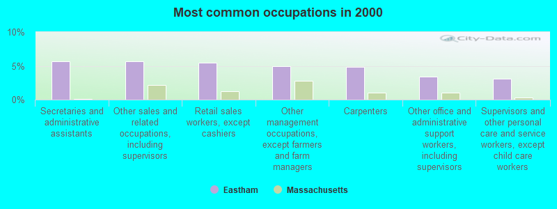
- Secretaries and administrative assistants (5.7%)
- Other sales and related occupations, including supervisors (5.7%)
- Retail sales workers, except cashiers (5.4%)
- Other management occupations, except farmers and farm managers (4.9%)
- Carpenters (4.9%)
- Other office and administrative support workers, including supervisors (3.4%)
- Supervisors and other personal care and service workers, except child care workers (3.1%)
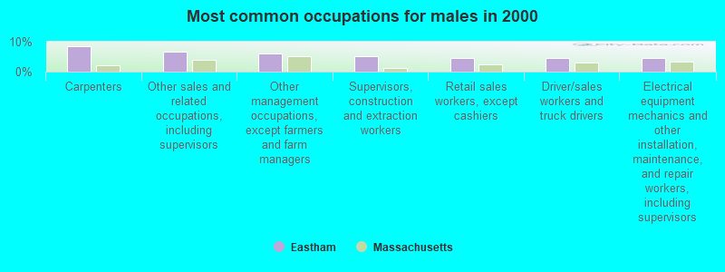
- Carpenters (8.6%)
- Other sales and related occupations, including supervisors (6.8%)
- Other management occupations, except farmers and farm managers (6.0%)
- Supervisors, construction and extraction workers (5.0%)
- Retail sales workers, except cashiers (4.7%)
- Driver/sales workers and truck drivers (4.4%)
- Electrical equipment mechanics and other installation, maintenance, and repair workers, including supervisors (4.4%)

- Secretaries and administrative assistants (11.8%)
- Other office and administrative support workers, including supervisors (6.4%)
- Retail sales workers, except cashiers (6.2%)
- Supervisors and other personal care and service workers, except child care workers (5.9%)
- Registered nurses (4.9%)
- Other sales and related occupations, including supervisors (4.5%)
- Preschool, kindergarten, elementary, and middle school teachers (4.4%)
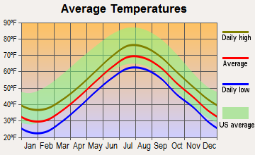
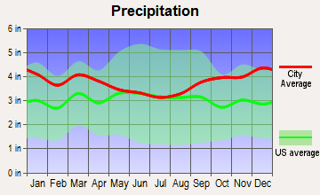
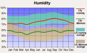
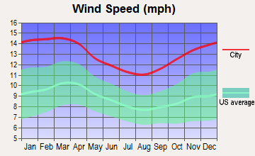
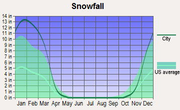
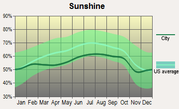
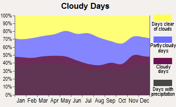
Average climate in Eastham, Massachusetts
Based on data reported by over 4,000 weather stations
(lower is better)
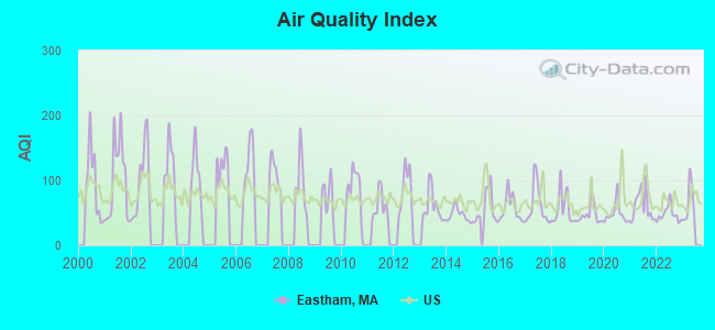
Air Quality Index (AQI) level in 2022 was 48.0. This is significantly better than average.
| City: | 48.0 |
| U.S.: | 72.6 |
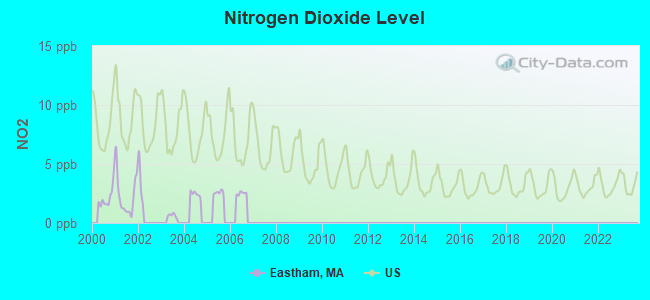
Nitrogen Dioxide (NO2) [ppb] level in 2001 was 2.30. This is significantly better than average. Closest monitor was 9.6 miles away from the city center.
| City: | 2.30 |
| U.S.: | 5.11 |
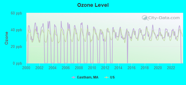
Ozone [ppb] level in 2022 was 34.8. This is about average. Closest monitor was 9.6 miles away from the city center.
| City: | 34.8 |
| U.S.: | 33.3 |
Earthquake activity:
Eastham-area historical earthquake activity is significantly above Massachusetts state average. It is 78% smaller than the overall U.S. average.On 10/16/2012 at 23:12:25, a magnitude 4.7 (4.7 ML, Depth: 10.0 mi, Class: Light, Intensity: IV - V) earthquake occurred 126.2 miles away from Eastham center
On 1/19/1982 at 00:14:42, a magnitude 4.7 (4.5 MB, 4.7 MD, 4.5 LG) earthquake occurred 141.2 miles away from the city center
On 4/20/2002 at 10:50:47, a magnitude 5.3 (5.3 ML, Depth: 3.0 mi, Class: Moderate, Intensity: VI - VII) earthquake occurred 263.1 miles away from Eastham center
On 10/7/1983 at 10:18:46, a magnitude 5.3 (5.1 MB, 5.3 LG, 5.1 ML) earthquake occurred 264.7 miles away from the city center
On 4/20/2002 at 10:50:47, a magnitude 5.2 (5.2 MB, 4.2 MS, 5.2 MW, 5.0 MW) earthquake occurred 262.6 miles away from the city center
On 8/22/1992 at 12:20:32, a magnitude 4.8 (4.8 MB, 3.8 MS, 4.7 LG, Depth: 6.2 mi) earthquake occurred 189.9 miles away from Eastham center
Magnitude types: regional Lg-wave magnitude (LG), body-wave magnitude (MB), duration magnitude (MD), local magnitude (ML), surface-wave magnitude (MS), moment magnitude (MW)
Natural disasters:
The number of natural disasters in Barnstable County (21) is greater than the US average (15).Major Disasters (Presidential) Declared: 11
Emergencies Declared: 8
Causes of natural disasters: Hurricanes: 7, Floods: 5, Storms: 4, Snows: 3, Snowstorms: 3, Winter Storms: 3, Blizzards: 2, Snowfall: 1, Tropical Storm: 1, Wind: 1, Other: 1 (Note: some incidents may be assigned to more than one category).

Hospitals and medical centers near Eastham:
- PLEASANT BAY NURSING AND REHABILITATION (Nursing Home, about 8 miles away; BREWSTER, MA)
- BREWSTER MANOR NURSING RET HOME (Nursing Home, about 9 miles away; BREWSTER, MA)
- EPOCH SENIOR HEALTHCARE OF BREWSTER (Nursing Home, about 9 miles away; BREWSTER, MA)
- BROAD REACH HOSPICE (Hospital, about 10 miles away; NORTH CHATHAM, MA)
- LIBERTY COMMONS (Nursing Home, about 10 miles away; NORTH CHATHAM, MA)
- EPOCH SENIOR HEALTHCARE OF HARWICH (Nursing Home, about 11 miles away; HARWICH, MA)
- HOSPICE OF VNA OF CEN AND OUTER CAPE COD (Hospital, about 14 miles away; SOUTH DENNIS, MA)
Colleges/universities with over 2000 students nearest to Eastham:
- Cape Cod Community College (about 21 miles; West Barnstable, MA; Full-time enrollment: 2,491)
- Bridgewater State University (about 52 miles; Bridgewater, MA; FT enrollment: 9,802)
- Massasoit Community College (about 55 miles; Brockton, MA; FT enrollment: 5,442)
- University of Massachusetts-Dartmouth (about 55 miles; North Dartmouth, MA; FT enrollment: 7,545)
- Stonehill College (about 59 miles; Easton, MA; FT enrollment: 2,563)
- Bristol Community College (about 60 miles; Fall River, MA; FT enrollment: 5,707)
- Quincy College (about 60 miles; Quincy, MA; FT enrollment: 3,184)
Public elementary/middle school in Eastham:
- EASTHAM ELEMENTARY (Students: 227, Location: 200 SCHOOLHOUSE ROAD, Grades: PK-5)
Points of interest:
Notable locations in Eastham: Nauset Beach Lighthouse (A), The Eastham Mill (B), Salt Pond Visitor Center (C), Eastham Fire Department (D), Eastham Public Library (E), Eastham 1869 Schoolhouse Museum (F). Display/hide their locations on the map
Cemeteries: Cove Burying Ground (1), Bridge Road Cemetery (2), Soldiers Cemetery (3), Evergreen Cemetery (4). Display/hide their locations on the map
Lakes and swamps: Mill Pond (A), Widow Harding Pond (B), Salt Pond (C), Moll Pond (D), Minister Pond (E), Jemima Pond (F), Herring Pond (G), Great Pond (H). Display/hide their locations on the map
Streams, rivers, and creeks: Hatches Creek (A), Herring River (B), Herring Brook (C), Boat Meadow River (D). Display/hide their locations on the map
Parks in Eastham include: Doane Rock Picnic Area (1), Windmill Park (2), Wiley Park (3). Display/hide their locations on the map
Beaches: Wiley Park Beach (A), First Encounter Beach (B), Nauset Light Beach (C), Coast Guard Beach (D), Nauset Beach (E). Display/hide their locations on the map
Tourist attractions: History Art USA (Cultural Attractions- Events- & Facilities; 2320 State Highway), United States Government - Interior Dept- National Park Service- Cape Cod National Seas (Recreation Areas; 1050 Nauset Road).
Hotels: Atlantic Breeze Motel & Cottages (5780 State Hwy), Four Points By Sheraton Eastham Cape Cod (Route 6), Hostelling INTL USA Enec-Mid-Cape (75 Goody Hallet Drive), Ocean Park Inn- Eastham- MA (3900 Route 6), Cove Bluffs Motel (25 Seaview Rd), Penny House Inn & Spa (4885 Route 6), Eagle Wing Motel (960 State Highway), Captain's Quarters (30 Captain Quarters Court), Painted Dog Guest Apartment The (2085 State Hwy).
Drinking water stations with addresses in Eastham and their reported violations in the past:
WILEY PARK CONSERVATION AREA (Address: 2500 STATE HIGHWAY , Population served: 250, Groundwater):Past health violations:WELLFLEET APARTMENTS (Address: 3 MAIN STREET MERCANTILE, UNIT #7 , Population served: 48, Groundwater):Past monitoring violations:
- MCL, Monthly (TCR) - In JUL-2008, Contaminant: Coliform. Follow-up actions: St AO (w/o penalty) issued (NOV-21-2008), St Compliance achieved (NOV-21-2008)
- Monitoring, Repeat Major (TCR) - In AUG-2013, Contaminant: Coliform (TCR). Follow-up actions: St AO (w/o penalty) issued (NOV-29-2013)
- Monitoring, Repeat Major (TCR) - In AUG-2008, Contaminant: Coliform (TCR). Follow-up actions: St AO (w/o penalty) issued (FEB-27-2009)
- Monitoring, Repeat Major (TCR) - In JUL-2008, Contaminant: Coliform (TCR). Follow-up actions: St AO (w/o penalty) issued (NOV-21-2008), St Compliance achieved (NOV-21-2008)
- 3 routine major monitoring violations
- One minor monitoring violation
Past monitoring violations:
- Follow-up Or Routine LCR Tap M/R - In OCT-01-2007, Contaminant: Lead and Copper Rule. Follow-up actions: St AO (w/o penalty) issued (NOV-14-2007), St Compliance achieved (NOV-14-2008)
- One routine major monitoring violation
| This town: | 2.1 people |
| Massachusetts: | 2.5 people |
| This town: | 62.3% |
| Whole state: | 63.0% |
| This town: | 6.4% |
| Whole state: | 7.0% |
Likely homosexual households (counted as self-reported same-sex unmarried-partner households)
- Lesbian couples: 1.2% of all households
- Gay men: 1.1% of all households
| This town: | 7.0% |
| Whole state: | 9.3% |
| This town: | 2.7% |
| Whole state: | 4.4% |
People in group quarters in Eastham in 2000:
- 61 people in other workers' dormitories
- 7 people in other group homes
- 6 people in other noninstitutional group quarters
For population 15 years and over in Eastham:
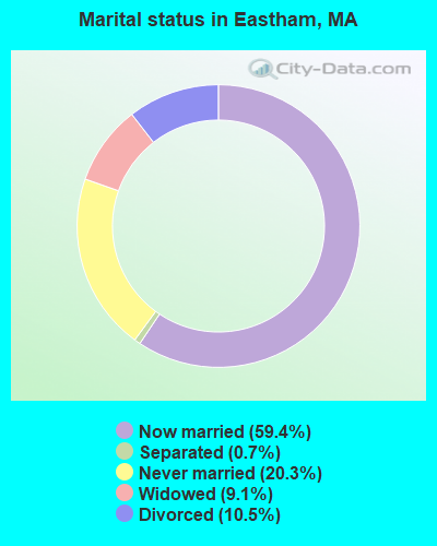
- Never married: 20.3%
- Now married: 59.4%
- Separated: 0.7%
- Widowed: 9.1%
- Divorced: 10.5%
For population 25 years and over in Eastham:
- High school or higher: 93.4%
- Bachelor's degree or higher: 35.3%
- Graduate or professional degree: 16.2%
- Unemployed: 4.9%
- Mean travel time to work (commute): 26.4 minutes
| Here: | 10.2 |
| Massachusetts average: | 13.1 |
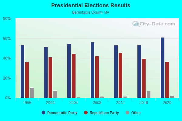
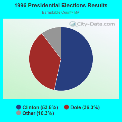
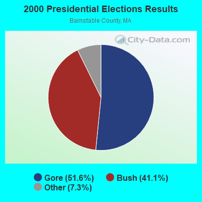

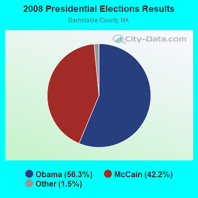

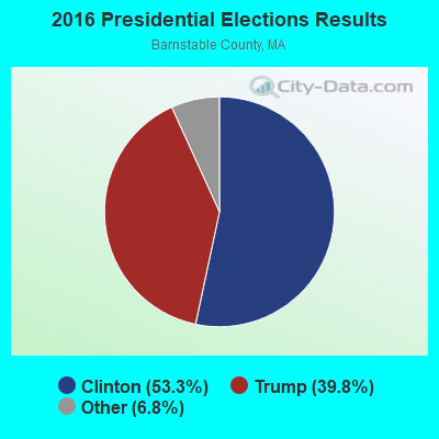
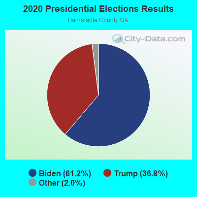
Graphs represent county-level data. Detailed 2008 Election Results
Religion statistics for Eastham, MA (based on Barnstable County data)
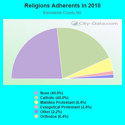
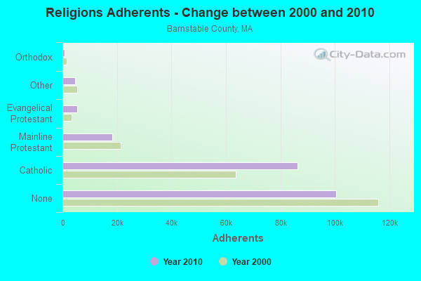
| Religion | Adherents | Congregations |
|---|---|---|
| Catholic | 86,370 | 18 |
| Mainline Protestant | 18,165 | 68 |
| Evangelical Protestant | 5,281 | 46 |
| Other | 4,734 | 32 |
| Orthodox | 810 | 3 |
| None | 100,528 | - |
Food Environment Statistics:
| Here: | 3.06 / 10,000 pop. |
| State: | 1.98 / 10,000 pop. |
| This county: | 0.05 / 10,000 pop. |
| Massachusetts: | 0.05 / 10,000 pop. |
| Here: | 3.38 / 10,000 pop. |
| State: | 2.22 / 10,000 pop. |
| Here: | 2.57 / 10,000 pop. |
| Massachusetts: | 1.77 / 10,000 pop. |
| Barnstable County: | 18.60 / 10,000 pop. |
| Massachusetts: | 8.76 / 10,000 pop. |
| Barnstable County: | 7.9% |
| Massachusetts: | 8.1% |
| This county: | 19.6% |
| Massachusetts: | 22.5% |
| This county: | 13.8% |
| State: | 16.5% |
| Businesses in Eastham, MA | ||||
| Name | Count | Name | Count | |
|---|---|---|---|---|
| Ace Hardware | 1 | Goodwill | 2 | |
| Dunkin Donuts | 1 | UPS | 1 | |
| FedEx | 1 | |||
Strongest AM radio stations in Eastham:
- WFPB (1170 AM; daytime; 1 kW; ORLEANS, MA; Owner: UNIVERSITY OF MASSACHUSETTS)
- WBZ (1030 AM; 50 kW; BOSTON, MA; Owner: INFINITY BROADCASTING OPERATIONS, INC.)
- WRKO (680 AM; 50 kW; BOSTON, MA; Owner: ENTERCOM BOSTON LICENSE, LLC)
- WEEI (850 AM; 50 kW; BOSTON, MA; Owner: ENTERCOM BOSTON LICENSE, LLC)
- WALE (990 AM; 50 kW; GREENVILLE, RI; Owner: NORTH AMERICAN BROADCASTING CO., INC.)
- WKOX (1200 AM; 50 kW; FRAMINGHAM, MA; Owner: CAPSTAR TX LIMITED PARTNERSHIP)
- WWZN (1510 AM; 50 kW; BOSTON, MA; Owner: ROSE CITY RADIO CORPORATION)
- WBIX (1060 AM; 40 kW; NATICK, MA; Owner: LANGER BROADCASTING CORPORATION)
- WCRN (830 AM; 50 kW; WORCESTER, MA; Owner: CARTER BROADCASTING CORPORATION)
- WAMG (890 AM; 25 kW; DEDHAM, MA; Owner: MEGA COMMUNICATIONS OF DEDHAM LICENSEE, LLC)
- WNNZ (640 AM; 50 kW; WESTFIELD, MA; Owner: CLEAR CHANNEL BROADCASTING LICENSES, INC.)
- WRCA (1330 AM; 25 kW; WALTHAM, MA; Owner: WRCA LICENSE, LLC)
- WUNR (1600 AM; 20 kW; BROOKLINE, MA; Owner: CHAMPION BROADCASTING SYSTEMS, INC.)
Strongest FM radio stations in Eastham:
- WKPE-FM (104.7 FM; ORLEANS, MA; Owner: CRB WKPE LIC CORP.)
- WFCC-FM (107.5 FM; CHATHAM, MA; Owner: CHARLES RIVER B/CING WFCC LIC. CORP.)
- WDVT (93.5 FM; HARWICH PORT, MA; Owner: BOCH BROADCASTING, L.P.)
- WCOD-FM (106.1 FM; HYANNIS, MA; Owner: BOCH BROADCASTING, L.P.)
- WOCN-FM (103.9 FM; SOUTH YARMOUTH, MA; Owner: SANDAB COMMUNICATIONS LTD. PARTNERSHIP II)
- WPXC (102.9 FM; HYANNIS, MA; Owner: QANTUM OF CAPE COD LICENSE COMPANY, LLC)
- WXTK (95.1 FM; WEST YARMOUTH, MA; Owner: BOCH BROADCASTING LTD. PARTNERSHIP)
- WQRC (99.9 FM; BARNSTABLE, MA; Owner: SANDAB COMMUNICATION LTD. PNR/SHP II)
- WCDJ (102.3 FM; TRURO, MA; Owner: TRURO WIRELESS, INC.)
- WCCT-FM (90.3 FM; HARWICH, MA; Owner: CAPE COD REGIONAL TECH HIGH SCHOOL)
TV broadcast stations around Eastham:
- W08CH (Channel 8; HYANNIS, MA; Owner: WGBH EDUCATIONAL FOUNDATION)
- WDPX (Channel 58; VINEYARD HAVEN, MA; Owner: PAXSON BOSTON-68 LICENSE, INC.)
- WMPX-LP (Channel 67; DENNIS, MA; Owner: PAXSON BOSTON-68 LICENSE, INC.)
- National Bridge Inventory (NBI) Statistics
- 1Number of bridges
- 7ft / 1.9mTotal length
- $968,000Total costs
- 6,410Total average daily traffic
- 384Total average daily truck traffic
- 15,929Total future (year 2032) average daily traffic
FCC Registered Cell Phone Towers:
1- Lot 25 2470 Nauset Rd (76837) (Lat: 41.867167 Lon: -69.981083), Type: Ltower, Structure height: 59.4 m, Call Sign: KNKN705
Assigned Frequencies: 869.040 MHz, 869.040 MHz, 869.040 MHz, 824.040 MHz, 824.040 MHz, 824.040 MHz, 890.010 MHz, 890.010 MHz, 890.010 MHz, 845.010 MHz, 845.010 MHz, 845.010 MHzGrant Date: 09/01/2020, Expiration Date: 10/01/2030, Certifier: Michael P GogginRegistrant: At&t Services, Inc., 208 S Akard St, 20f, Dallas, TX 75202, Phone: (855) 699-7073, Fax: (214) 746-6410, Email:
FCC Registered Broadcast Land Mobile Towers:
4- Orchard Rd (Lat: 41.849556 Lon: -69.980583), Call Sign: KNAU486,
Assigned Frequencies: 45.8400 MHz, Grant Date: 06/24/1996, Expiration Date: 07/16/2001, Cancellation Date: 09/16/2001, Registrant: Eastham, Town Of, Orchard Rd, Eastham, MA 02642, Phone: (508) 255-0333
- Route 6 (Lat: 41.830667 Lon: -69.978639), Call Sign: KCB710,
Assigned Frequencies: 155.520 MHz, 155.565 MHz, 155.640 MHz, 155.700 MHz, 158.850 MHz, Grant Date: 04/30/2015, Expiration Date: 05/07/2025, Registrant: Barnstable County Sheriff\'s Office, 6000 Sheriff\'s Place, Bourne, MA 02532, Phone: (508) 563-4210, Fax: (580) 563-4288, Email:
- 2 Ocean View Dr. (Lat: 41.844194 Lon: -69.947194), Type: Mtower, Structure height: 0 m, Overall height: 9 m, Call Sign: WRPW608,
Assigned Frequencies: 4.46300 MHz, Grant Date: 03/25/2022, Expiration Date: 03/25/2032, Certifier: Richard P Arena, Registrant: University Of Massachusetts - Dartmouth, 836 South Rodney French Blvd, New Bedford, MA 02744, Phone: (508) 910-6377, Email:
- Lat: 41.866639 Lon: -69.980000, Call Sign: WRYU709,
Assigned Frequencies: 457.300 MHz, Grant Date: 09/19/2023, Expiration Date: 09/19/2033, Certifier: Francesca Pillon, Registrant: Kamstrup Water Metering, LLC, 245 Hembree Park Drive, Ste. 110, Roswell, GA 30076, Phone: (404) 835-6716, Email:
FCC Registered Microwave Towers:
1- BS03XC321, 2740 Nasuet Rd. (Lat: 41.867056 Lon: -69.981028), Type: Mtower, Structure height: 59.4 m, Call Sign: WQPU657,
Assigned Frequencies: 11665.0 MHz, 11665.0 MHz, 11665.0 MHz, Grant Date: 08/20/2012, Expiration Date: 08/20/2022, Cancellation Date: 08/15/2022, Certifier: David Werblow, Registrant: Dla Piper LLP, 500 8th Street, Nw, Washington, DC 20004, Phone: (202) 799-4216, Fax: (202) 799-5616, Email:
FCC Registered Amateur Radio Licenses:
142 (See the full list of FCC Registered Amateur Radio Licenses in Eastham)FAA Registered Aircraft:
3- Aircraft: CESSNA 150L (Category: Land, Seats: 2, Weight: Up to 12,499 Pounds, Speed: 90 mph), Engine: CONT MOTOR 0-200 SERIES (100 HP) (Reciprocating)
N-Number: 11971, N11971, N-11971, Serial Number: 15075749, Year manufactured: 1974, Airworthiness Date: 04/11/1974, Certificate Issue Date: 07/20/2020
Registrant (Corporation): Gsi Corp, 15 Fallon Rd, Eastham, MA 02642 - Aircraft: BAUDER JAMES B8-M (Category: Land, Weight: Up to 12,499 Pounds), Engine: MCCULLOCH 4318A&E/0-100 (72 HP) (2 Cycle)
N-Number: 4695, N4695, N-4695, Serial Number: 1, Year manufactured: 1971, Airworthiness Date: 09/07/1973, Certificate Issue Date: 07/21/2015
Registrant (Individual): James L Bauder, 355 Governor Prence Rd, Eastham, MA 02642 - Aircraft: BEECH B23 (Category: Land, Seats: 4, Weight: Up to 12,499 Pounds, Speed: 116 mph), Engine: LYCOMING O&VO-360 SER (180 HP) (Reciprocating)
N-Number: 7660R, N7660R, N-7660R, Serial Number: M-1282, Year manufactured: 1969, Airworthiness Date: 11/03/1969, Certificate Issue Date: 12/09/2016
Registrant (Individual): Sherwood P Jr Doolittle, 95 S Sunken Meadow Rd, Eastham, MA 02642
2002 - 2018 National Fire Incident Reporting System (NFIRS) incidents
- Fire incident types reported to NFIRS in Eastham, MA
- 29856.9%Structure Fires
- 16531.5%Outside Fires
- 377.1%Mobile Property/Vehicle Fires
- 244.6%Other
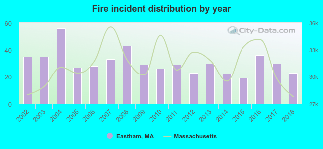 According to the data from the years 2002 - 2018 the average number of fire incidents per year is 31. The highest number of fire incidents - 56 took place in 2004, and the least - 19 in 2015. The data has a declining trend.
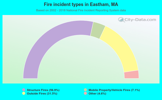 When looking into fire subcategories, the most incidents belonged to: Structure Fires (56.9%), and Outside Fires (31.5%).
Fire-safe hotels and motels in Eastham, Massachusetts:
- Town Crier Motel, 3620 State Hwy, Eastham, Massachusetts 02642 , Phone: (508) 255-4000, Fax: (508) 255-7491
- Four Points By Sheraton Eastham, 3800 State Hwy, Eastham, Massachusetts 02642 , Phone: (508) 255-5000
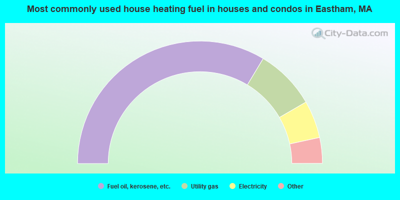
- 67.2%Fuel oil, kerosene, etc.
- 16.0%Utility gas
- 9.9%Electricity
- 2.8%Bottled, tank, or LP gas
- 1.3%Wood
- 1.2%Coal or coke
- 1.1%Other fuel
- 0.4%Solar energy
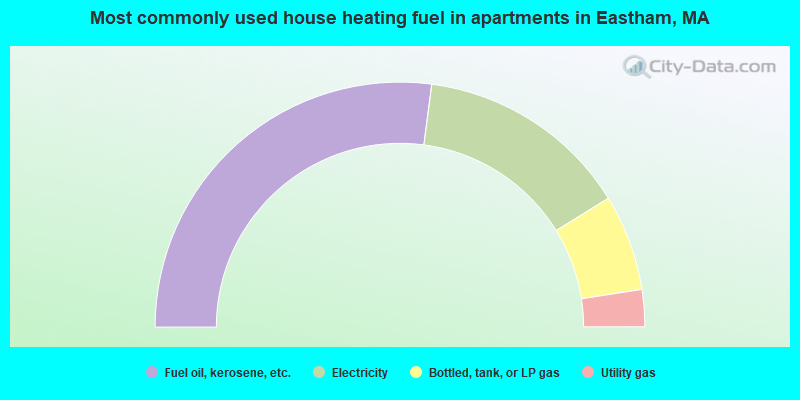
- 54.1%Fuel oil, kerosene, etc.
- 28.2%Electricity
- 12.7%Bottled, tank, or LP gas
- 4.9%Utility gas
Eastham compared to Massachusetts state average:
- Unemployed percentage significantly below state average.
- Black race population percentage significantly below state average.
- Hispanic race population percentage significantly below state average.
- Median age significantly above state average.
- Foreign-born population percentage significantly below state average.
- Renting percentage significantly below state average.
- Length of stay since moving in significantly above state average.
- Number of rooms per house significantly below state average.
- House age significantly below state average.
- Number of college students below state average.
Eastham on our top lists:
- #37 on the list of "Top 101 cities with the largest percentage of people in other workers' dormitories (population 1,000+)"
- #1 on the list of "Top 101 counties with the highest percentage of residents that smoked 100+ cigarettes in their lives"
- #7 on the list of "Top 101 counties with the lowest number of births per 1000 residents 2007-2013"
- #9 on the list of "Top 101 counties with the highest percentage of residents that visited a dentist within the past year"
- #10 on the list of "Top 101 counties with the lowest average weight of females"
- #24 on the list of "Top 101 counties with the largest number of people without health insurance coverage in 2000 (pop. 50,000+)"

|
|
Total of 36 patent applications in 2008-2024.