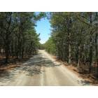
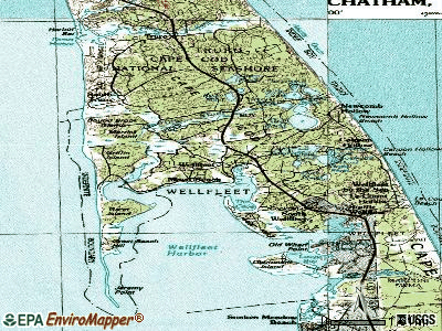
Wellfleet, Massachusetts

Wellfleet: Sunset

Wellfleet: Sunset

Wellfleet: Sunset

Wellfleet: Fishing on Gull Pond
Wellfleet: Wellfleet

Wellfleet: Fishing on Gull Pond

Wellfleet: My Weimaraner Duck Harbor Sunset
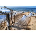
Wellfleet: Snow fencing Great Island Beach

Wellfleet: Fishing boats at dock in Winter
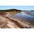
Wellfleet: Winter Colors on Great Island
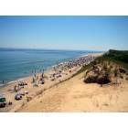
Wellfleet: Beach
- see
13
more - add
your
Submit your own pictures of this town and show them to the world
- OSM Map
- General Map
- Google Map
- MSN Map
Population change since 2000: +0.0%
 |
| Males: 1,284 | |
| Females: 1,466 |
| Median resident age: | 53.5 years |
| Massachusetts median age: | 39.2 years |
Zip codes: 02667.
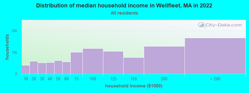
| Wellfleet: | $86,710 |
| MA: | $94,488 |
Estimated per capita income in 2022: $61,306 (it was $25,712 in 2000)
Wellfleet town income, earnings, and wages data
Estimated median house or condo value in 2022: $831,998 (it was $234,700 in 2000)
| Wellfleet: | $831,998 |
| MA: | $534,700 |
Mean prices in 2022: all housing units: $623,757; detached houses: $648,447; townhouses or other attached units: $490,502; in 2-unit structures: $577,155; in 3-to-4-unit structures: $445,551; in 5-or-more-unit structures: $351,307; mobile homes: $108,058
Detailed information about poverty and poor residents in Wellfleet, MA


Compare current foreclosures near Wellfleet, MA:
| Photo | Address | Area | Beds / Baths | Price | Details |
|---|---|---|---|---|---|

|
#1
Buck St
Wellfleet, MA 02667
|
1,248 sq. feet
|
1 baths 3 beds |
show details | |

|
#2
Main St
Wellfleet, MA 02667
|
2,972 sq. feet
|
- baths - beds |
show details | |

|
#3
G St
Wellfleet, MA 02667
|
- sq. feet
|
- baths - beds |
show details | |

|
#4
Main St
Brewster, MA 02631
|
1,881 sq. feet
|
2 baths 5 beds |
show details | |

|
#5
Winthrop St # 4
Provincetown, MA 02657
|
255 sq. feet
|
1 baths 1 beds |
show details | |

|
#6
Main St
Harwich, MA 02645
|
1,248 sq. feet
|
2 baths 3 beds |
show details | |

|
#7
Chatham Rd
Harwich, MA 02645
|
1,230 sq. feet
|
2 baths 4 beds |
show details | |

|
#8
Juniper Ln
Harwich, MA 02645
|
1,437 sq. feet
|
2 baths 2 beds |
show details | |

|
#9
Long Pond Dr
Harwich, MA 02645
|
1,856 sq. feet
|
3 baths 5 beds |
show details | |

|
#10
Pleasant Bay Rd
Harwich, MA 02645
|
1,434 sq. feet
|
3 baths 3 beds |
show details |
| Photo | Address | Area | Beds / Baths | Price | Details |
|---|---|---|---|---|---|

|
#11
Kimberley Way
Harwich, MA 02645
|
1,920 sq. feet
|
2 baths 3 beds |
show details | |

|
#12
Jonathans Way
Brewster, MA 02631
|
1,020 sq. feet
|
1 baths 2 beds |
show details | |

|
#13
Hazel Ln
Brewster, MA 02631
|
1,372 sq. feet
|
1 baths 3 beds |
show details | |

|
#14
Ebenezar Ln
Brewster, MA 02631
|
768 sq. feet
|
1 baths 2 beds |
show details | |

|
#15
Conant St
Provincetown, MA 02657
|
2,714 sq. feet
|
4 baths 6 beds |
show details | |

|
#16
Yankee Dr # 1
Brewster, MA 02631
|
1,025 sq. feet
|
1 baths 2 beds |
show details | |

|
#17
Brewster Cross Rd
Orleans, MA 02653
|
1,364 sq. feet
|
1 baths 3 beds |
show details | |

|
#18
Sea Gull Ln
Eastham, MA 02642
|
1,507 sq. feet
|
2 baths 3 beds |
show details | |

|
#19
Bain Rd
Eastham, MA 02642
|
1,196 sq. feet
|
2 baths 3 beds |
show details | |

|
#20
Old Colony Way Apt 30
Orleans, MA 02653
|
814 sq. feet
|
1 baths 1 beds |
show details |
| Photo | Address | Area | Beds / Baths | Price | Details |
|---|---|---|---|---|---|

|
#21
Great Western Rd
Harwich, MA 02645
|
1,008 sq. feet
|
1 baths 3 beds |
show details | |

|
#22
Calvin Dr
Dennis, MA 02638
|
- sq. feet
|
2 baths 3 beds |
show details | |

|
#23
Compass Ln
Dennis, MA 02638
|
- sq. feet
|
2 baths 3 beds |
show details | |

|
#24
S Orleans Rd
Orleans, MA 02653
|
- sq. feet
|
- baths - beds |
show details | |

|
#25
Old Comers Rd
Chatham, MA 02633
|
- sq. feet
|
- baths - beds |
show details | |

|
#26
Sachemus Trl
Brewster, MA 02631
|
- sq. feet
|
- baths - beds |
show details | |

|
#27
State Hwy
Eastham, MA 02642
|
- sq. feet
|
- baths - beds |
show details | |

|
#28
Main St
Chatham, MA 02633
|
- sq. feet
|
- baths - beds |
show details | |

|
#29
Depot Rd
Harwich, MA 02645
|
- sq. feet
|
- baths - beds |
show details | |

|
#30
N Westgate Rd
Harwich, MA 02645
|
- sq. feet
|
- baths - beds |
show details |
| Photo | Address | Area | Beds / Baths | Price | Details |
|---|---|---|---|---|---|

|
#31
Massasoit Rd
Eastham, MA 02642
|
- sq. feet
|
- baths - beds |
show details | |

|
#32
Winthrop S 4
Provincetown, MA 02657
|
- sq. feet
|
- baths - beds |
show details | |

|
#33
Bradford St
Provincetown, MA 02657
|
- sq. feet
|
- baths - beds |
show details | |

|
#34
Chris Jobeth Cir
Harwich, MA 02645
|
- sq. feet
|
- baths - beds |
show details | |

|
#35
State Hwy
Eastham, MA 02642
|
- sq. feet
|
- baths - beds |
show details | |

|
#36
Commercial St
Provincetown, MA 02657
|
- sq. feet
|
- baths - beds |
show details | |

|
#37
Center St
South Dennis, MA 02660
|
- sq. feet
|
- baths - beds |
show details | |

|
#38
Bridge Rd
Eastham, MA 02642
|
- sq. feet
|
- baths - beds |
show details | |

|
#39
Ellis Rd
Orleans, MA 02653
|
- sq. feet
|
- baths - beds |
show details | |

|
#40
Main St
Orleans, MA 02653
|
- sq. feet
|
- baths - beds |
show details |
| Photo | Address | Area | Beds / Baths | Price | Details |
|---|---|---|---|---|---|

|
#41
Old Colo H-2-30
Orleans, MA 02653
|
- sq. feet
|
- baths - beds |
show details | |

|
#42
Main St
Brewster, MA 02631
|
- sq. feet
|
- baths - beds |
show details | |

|
#43
Orleans Rd
Harwich, MA 02645
|
- sq. feet
|
- baths - beds |
show details | |

|
#44
Depot Rd
Harwich, MA 02645
|
- sq. feet
|
- baths - beds |
show details | |

|
Check over 1 million property listings on Foreclosure.com!
|
browse all offers | |||

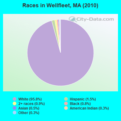
- 2,63595.8%White alone
- 411.5%Hispanic
- 250.9%Two or more races
- 220.8%Black alone
- 130.5%Asian alone
- 70.3%American Indian alone
- 70.3%Other race alone
Races in Wellfleet detailed stats: ancestries, foreign born residents, place of birth
According to our research of Massachusetts and other state lists, there was 1 registered sex offender living in Wellfleet, Massachusetts as of May 19, 2024.
The ratio of all residents to sex offenders in Wellfleet is 2,750 to 1.
The ratio of registered sex offenders to all residents in this city is lower than the state average.
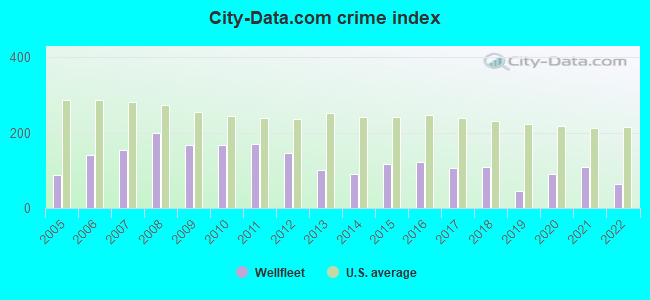
Type |
2009 |
2010 |
2011 |
2012 |
2013 |
2014 |
2015 |
2016 |
2017 |
2018 |
2019 |
2020 |
2021 |
2022 |
|---|---|---|---|---|---|---|---|---|---|---|---|---|---|---|
| Murders (per 100,000) | 0 (0.0) | 0 (0.0) | 0 (0.0) | 0 (0.0) | 0 (0.0) | 0 (0.0) | 0 (0.0) | 0 (0.0) | 0 (0.0) | 0 (0.0) | 0 (0.0) | 0 (0.0) | 0 (0.0) | 0 (0.0) |
| Rapes (per 100,000) | 0 (0.0) | 0 (0.0) | 0 (0.0) | 0 (0.0) | 0 (0.0) | 0 (0.0) | 2 (72.6) | 2 (73.1) | 0 (0.0) | 1 (36.6) | 0 (0.0) | 1 (36.9) | 2 (72.8) | 2 (53.7) |
| Robberies (per 100,000) | 0 (0.0) | 1 (36.4) | 0 (0.0) | 1 (36.1) | 0 (0.0) | 0 (0.0) | 0 (0.0) | 0 (0.0) | 1 (36.3) | 0 (0.0) | 0 (0.0) | 0 (0.0) | 0 (0.0) | 0 (0.0) |
| Assaults (per 100,000) | 4 (145.0) | 7 (254.5) | 9 (325.3) | 5 (180.4) | 4 (145.6) | 4 (146.1) | 2 (72.6) | 1 (36.5) | 2 (72.5) | 4 (146.4) | 0 (0.0) | 6 (221.6) | 4 (145.6) | 1 (26.8) |
| Burglaries (per 100,000) | 34 (1,233) | 15 (545.5) | 17 (614.4) | 19 (685.4) | 13 (473.2) | 4 (146.1) | 4 (145.1) | 6 (219.2) | 17 (616.6) | 4 (146.4) | 6 (221.8) | 1 (36.9) | 1 (36.4) | 3 (80.5) |
| Thefts (per 100,000) | 32 (1,160) | 45 (1,636) | 32 (1,156) | 32 (1,154) | 24 (873.7) | 27 (986.5) | 22 (798.3) | 23 (840.3) | 22 (798.0) | 27 (987.9) | 19 (702.4) | 9 (332.5) | 12 (436.8) | 8 (214.8) |
| Auto thefts (per 100,000) | 2 (72.5) | 1 (36.4) | 5 (180.7) | 2 (72.2) | 1 (36.4) | 4 (146.1) | 1 (36.3) | 3 (109.6) | 2 (72.5) | 0 (0.0) | 0 (0.0) | 0 (0.0) | 1 (36.4) | 1 (26.8) |
| Arson (per 100,000) | 0 (0.0) | 0 (0.0) | 1 (36.1) | 1 (36.1) | 2 (72.8) | 0 (0.0) | 0 (0.0) | 0 (0.0) | 2 (72.5) | 0 (0.0) | 0 (0.0) | 0 (0.0) | 0 (0.0) | 0 (0.0) |
| City-Data.com crime index | 167.5 | 168.4 | 168.8 | 146.8 | 100.1 | 90.6 | 117.6 | 123.5 | 106.3 | 108.3 | 43.6 | 89.8 | 110.3 | 64.7 |
The City-Data.com crime index weighs serious crimes and violent crimes more heavily. Higher means more crime, U.S. average is 246.1. It adjusts for the number of visitors and daily workers commuting into cities.
Crime rate in Wellfleet detailed stats: murders, rapes, robberies, assaults, burglaries, thefts, arson
Full-time law enforcement employees in 2021, including police officers: 19 (14 officers - 14 male; 0 female).
| Officers per 1,000 residents here: | 5.10 |
| Massachusetts average: | 2.53 |
 Recent articles from our blog. Our writers, many of them Ph.D. graduates or candidates, create easy-to-read articles on a wide variety of topics.

 | Cape Cod observations from a 1st timer (77 replies) |
| Best Cape Cod Towns Vacation (23 replies) |
| Shark Attack at Cape Cod beach (175 replies) |
| Summer home in Cape Cod to rent out for eventual retirement (31 replies) |
| Is Newburyport the most quintessential coastal town in Mass? (27 replies) |
| Cape Cod: Family Vacation advice (11 replies) |
Latest news from Wellfleet, MA collected exclusively by city-data.com from local newspapers, TV, and radio stations
Ancestries: English (29.6%), Irish (25.6%), German (12.1%), Portuguese (10.3%), Italian (9.2%), French (7.5%).
Current Local Time: EST time zone
Incorporated in 1775
Elevation: 50 feet
Land area: 19.8 square miles.
Population density: 139 people per square mile (very low).
95 residents are foreign born (2.6% Europe, 0.5% North America).
| This town: | 3.5% |
| Massachusetts: | 12.2% |
| Wellfleet town: | 0.7% ($1,577) |
| Massachusetts: | 1.3% ($2,336) |
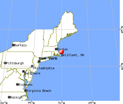
Nearest city with pop. 50,000+: New Bedford, MA  (51.0 miles , pop. 93,768).
Nearest city with pop. 200,000+: Boston, MA (61.6 miles , pop. 589,141).
Nearest city with pop. 1,000,000+: Bronx, NY (213.6 miles , pop. 1,332,650).
Nearest cities:
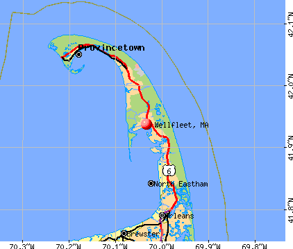
)Latitude: 41.92 N, Longitude: 70.01 W
Area codes: 508, 774

Wellfleet tourist attractions:
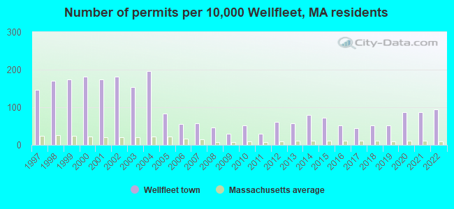
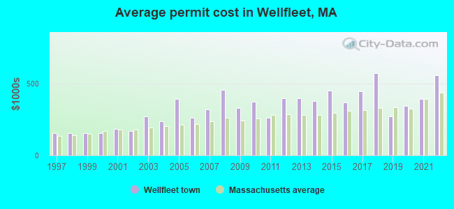
Single-family new house construction building permits:
- 2022: 26 buildings, average cost: $558,000
- 2021: 24 buildings, average cost: $393,500
- 2020: 24 buildings, average cost: $344,100
- 2019: 14 buildings, average cost: $272,400
- 2018: 14 buildings, average cost: $573,200
- 2017: 12 buildings, average cost: $448,900
- 2016: 14 buildings, average cost: $367,700
- 2015: 20 buildings, average cost: $449,800
- 2014: 22 buildings, average cost: $378,100
- 2013: 16 buildings, average cost: $395,700
- 2012: 17 buildings, average cost: $395,700
- 2011: 8 buildings, average cost: $261,000
- 2010: 14 buildings, average cost: $371,900
- 2009: 8 buildings, average cost: $330,000
- 2008: 13 buildings, average cost: $458,300
- 2007: 16 buildings, average cost: $319,000
- 2006: 15 buildings, average cost: $263,500
- 2005: 23 buildings, average cost: $392,900
- 2004: 54 buildings, average cost: $236,200
- 2003: 42 buildings, average cost: $269,500
- 2002: 50 buildings, average cost: $168,300
- 2001: 48 buildings, average cost: $183,000
- 2000: 50 buildings, average cost: $155,900
- 1999: 48 buildings, average cost: $155,900
- 1998: 47 buildings, average cost: $155,900
- 1997: 40 buildings, average cost: $155,900
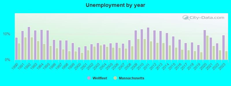
| Here: | 9.6% |
| Massachusetts: | 3.5% |
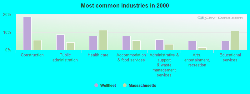
- Construction (18.7%)
- Public administration (8.7%)
- Health care (7.9%)
- Accommodation & food services (7.8%)
- Administrative & support & waste management services (5.9%)
- Arts, entertainment, recreation (5.2%)
- Educational services (5.1%)
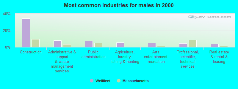
- Construction (34.2%)
- Administrative & support & waste management services (8.3%)
- Public administration (8.0%)
- Agriculture, forestry, fishing & hunting (5.6%)
- Arts, entertainment, recreation (5.4%)
- Professional, scientific, technical services (4.5%)
- Real estate & rental & leasing (3.8%)
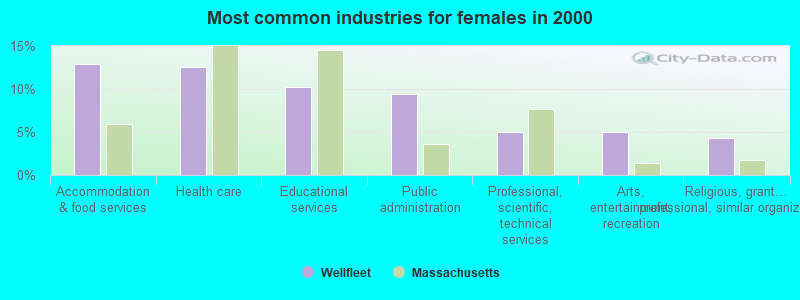
- Accommodation & food services (12.9%)
- Health care (12.6%)
- Educational services (10.2%)
- Public administration (9.5%)
- Professional, scientific, technical services (5.0%)
- Arts, entertainment, recreation (5.0%)
- Religious, grantmaking, civic, professional, similar organizations (4.3%)
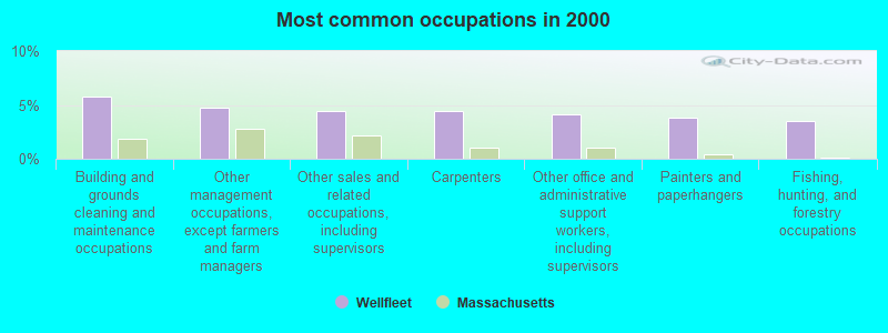
- Building and grounds cleaning and maintenance occupations (5.7%)
- Other management occupations, except farmers and farm managers (4.7%)
- Other sales and related occupations, including supervisors (4.5%)
- Carpenters (4.5%)
- Other office and administrative support workers, including supervisors (4.1%)
- Painters and paperhangers (3.8%)
- Fishing, hunting, and forestry occupations (3.5%)

- Carpenters (8.1%)
- Painters and paperhangers (7.7%)
- Building and grounds cleaning and maintenance occupations (6.0%)
- Fishing, hunting, and forestry occupations (5.6%)
- Driver/sales workers and truck drivers (5.3%)
- Supervisors, construction and extraction workers (4.8%)
- Other management occupations, except farmers and farm managers (4.5%)

- Other office and administrative support workers, including supervisors (8.1%)
- Information and record clerks, except customer service representatives (5.8%)
- Preschool, kindergarten, elementary, and middle school teachers (5.6%)
- Building and grounds cleaning and maintenance occupations (5.5%)
- Other sales and related occupations, including supervisors (5.0%)
- Other management occupations, except farmers and farm managers (4.9%)
- Registered nurses (4.3%)
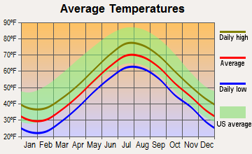
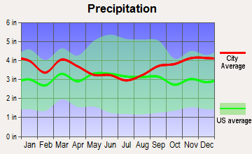
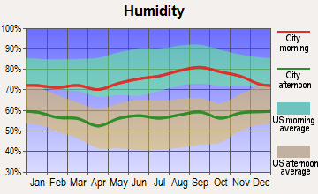
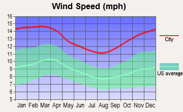
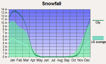
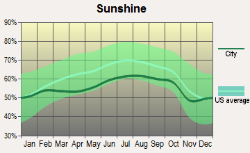
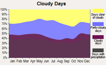
Average climate in Wellfleet, Massachusetts
Based on data reported by over 4,000 weather stations
(lower is better)
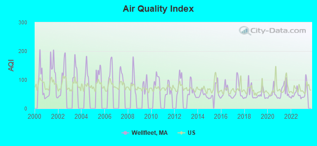
Air Quality Index (AQI) level in 2022 was 48.0. This is significantly better than average.
| City: | 48.0 |
| U.S.: | 72.6 |
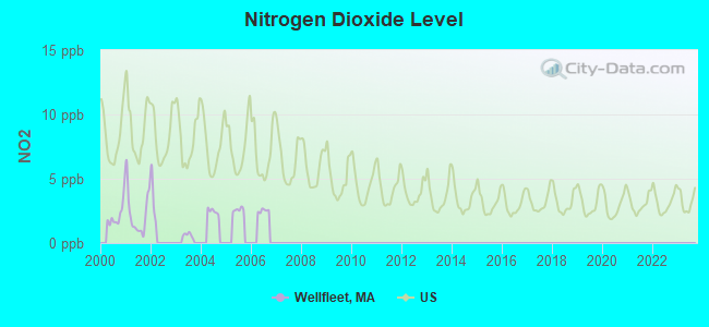
Nitrogen Dioxide (NO2) [ppb] level in 2001 was 2.30. This is significantly better than average. Closest monitor was 3.7 miles away from the city center.
| City: | 2.30 |
| U.S.: | 5.11 |
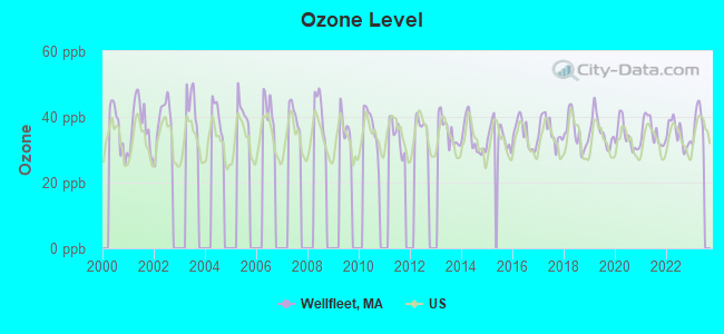
Ozone [ppb] level in 2022 was 34.8. This is about average. Closest monitor was 3.7 miles away from the city center.
| City: | 34.8 |
| U.S.: | 33.3 |
Earthquake activity:
Wellfleet-area historical earthquake activity is significantly above Massachusetts state average. It is 77% smaller than the overall U.S. average.On 10/16/2012 at 23:12:25, a magnitude 4.7 (4.7 ML, Depth: 10.0 mi, Class: Light, Intensity: IV - V) earthquake occurred 120.3 miles away from the city center
On 1/19/1982 at 00:14:42, a magnitude 4.7 (4.5 MB, 4.7 MD, 4.5 LG) earthquake occurred 135.6 miles away from Wellfleet center
On 4/20/2002 at 10:50:47, a magnitude 5.3 (5.3 ML, Depth: 3.0 mi, Class: Moderate, Intensity: VI - VII) earthquake occurred 257.9 miles away from the city center
On 10/7/1983 at 10:18:46, a magnitude 5.3 (5.1 MB, 5.3 LG, 5.1 ML) earthquake occurred 260.2 miles away from Wellfleet center
On 4/20/2002 at 10:50:47, a magnitude 5.2 (5.2 MB, 4.2 MS, 5.2 MW, 5.0 MW) earthquake occurred 257.5 miles away from Wellfleet center
On 8/22/1992 at 12:20:32, a magnitude 4.8 (4.8 MB, 3.8 MS, 4.7 LG, Depth: 6.2 mi) earthquake occurred 195.5 miles away from Wellfleet center
Magnitude types: regional Lg-wave magnitude (LG), body-wave magnitude (MB), duration magnitude (MD), local magnitude (ML), surface-wave magnitude (MS), moment magnitude (MW)
Natural disasters:
The number of natural disasters in Barnstable County (21) is greater than the US average (15).Major Disasters (Presidential) Declared: 11
Emergencies Declared: 8
Causes of natural disasters: Hurricanes: 7, Floods: 5, Storms: 4, Snows: 3, Snowstorms: 3, Winter Storms: 3, Blizzards: 2, Snowfall: 1, Tropical Storm: 1, Wind: 1, Other: 1 (Note: some incidents may be assigned to more than one category).
Hospitals and medical centers near Wellfleet:
- PLEASANT BAY NURSING AND REHABILITATION (Nursing Home, about 13 miles away; BREWSTER, MA)
- SEASHORE POINT AND WELLNESS REHABILITATION (Nursing Home, about 13 miles away; PROVINCETOWN, MA)
- BREWSTER MANOR NURSING RET HOME (Nursing Home, about 14 miles away; BREWSTER, MA)
- EPOCH SENIOR HEALTHCARE OF BREWSTER (Nursing Home, about 14 miles away; BREWSTER, MA)
- EPOCH SENIOR HEALTHCARE OF HARWICH (Nursing Home, about 16 miles away; HARWICH, MA)
- BROAD REACH HOSPICE (Hospital, about 16 miles away; NORTH CHATHAM, MA)
- LIBERTY COMMONS (Nursing Home, about 16 miles away; NORTH CHATHAM, MA)
Colleges/universities with over 2000 students nearest to Wellfleet:
- Cape Cod Community College (about 24 miles; West Barnstable, MA; Full-time enrollment: 2,491)
- Bridgewater State University (about 50 miles; Bridgewater, MA; FT enrollment: 9,802)
- Massasoit Community College (about 52 miles; Brockton, MA; FT enrollment: 5,442)
- University of Massachusetts-Dartmouth (about 55 miles; North Dartmouth, MA; FT enrollment: 7,545)
- Stonehill College (about 56 miles; Easton, MA; FT enrollment: 2,563)
- Quincy College (about 56 miles; Quincy, MA; FT enrollment: 3,184)
- Bristol Community College (about 59 miles; Fall River, MA; FT enrollment: 5,707)
Public elementary/middle school in Wellfleet:
- WELLFLEET ELEMENTARY (Students: 131, Location: 100 LAWRENCE ROAD, Grades: PK-5)
Points of interest:
Notable locations in Wellfleet: Wellfleet Drive-In (A), Wellfleet Town Pier (B), Mayos Beach Light (C), Maguire Landing (D), Wellfleet Fire Department (E), Marconi Station Site (F), Cape Cod National Seashore Headquarters (G), Wellfleet Historical Society Museum (H), Wellfleet Town Hall (I). Display/hide their locations on the map
Churches in Wellfleet include: Saint James Chuch (A), First Congregational Church (B). Display/hide their locations on the map
Cemeteries: South Wellfleet Cemetery (1), Pleasant Hill Cemetery (2), Oakdale Cemetery (3). Display/hide their locations on the map
Lakes and swamps: Williams Pond (A), Turtle Pond (B), Spectacle Pond (C), Southeast Pond (D), Perch Pond (E), Northeast Pond (F), Long Pond (G), Kinnacum Pond (H). Display/hide their locations on the map
Streams, rivers, and creeks: Silver Spring Brook (A), Mill Creek (B), Herring River (C), Bound Brook (D), Blackfish Creek (E). Display/hide their locations on the map
Park in Wellfleet: Audubon Bird Sanctuary (1). Display/hide its location on the map
Beaches: White Crest Beach (A), Maguire Landing Beach (B), Mayo Beach (C). Display/hide their locations on the map
Hotels: Duck Creeke Inn (70 Main Street) (1), Holbrook House (223 Main Street) (2). Display/hide their approximate locations on the map
Drinking water stations with addresses in Wellfleet and their reported violations in the past:
WELLFLEET MUNICIPAL WATER SUPPLY (Address: TOWN HALL, 300 MAIN ST , Population served: 675, Groundwater):Past health violations:HARBORSIDE VILLAGE (Population served: 200, Groundwater):
- MCL, Monthly (TCR) - In DEC-2011, Contaminant: Coliform. Follow-up actions: St AO (w/o penalty) issued (JAN-31-2012), St Compliance achieved (JAN-31-2012)
- MCL, Monthly (TCR) - In OCT-2011, Contaminant: Coliform. Follow-up actions: St AO (w/o penalty) issued (JAN-31-2012), St Compliance achieved (JAN-31-2012)
- MCL, Monthly (TCR) - In SEP-2010, Contaminant: Coliform. Follow-up actions: St AO (w/o penalty) issued (NOV-29-2010), St Compliance achieved (NOV-29-2010)
Past health violations:WINSLOW TAVERN (Population served: 175, Groundwater):Past monitoring violations:
- MCL, Monthly (TCR) - In AUG-2009, Contaminant: Coliform. Follow-up actions: St AO (w/o penalty) issued (DEC-07-2009), St Compliance achieved (DEC-07-2009)
- 2 routine major monitoring violations
- One minor monitoring violation
- 23 regular monitoring violations
Past monitoring violations:WICKED OYSTER RESTAURANT (Address: 50 MAIN STREET , Population served: 170, Groundwater):
- 2 routine major monitoring violations
- 2 regular monitoring violations
Past monitoring violations:
- One routine major monitoring violation
- 2 regular monitoring violations
Drinking water stations with addresses in Wellfleet that have no violations reported:
- PLEASANT WATER (Population served: 200, Primary Water Source Type: Groundwater)
| This town: | 2.0 people |
| Massachusetts: | 2.5 people |
| This town: | 53.0% |
| Whole state: | 63.0% |
| This town: | 9.7% |
| Whole state: | 7.0% |
Likely homosexual households (counted as self-reported same-sex unmarried-partner households)
- Lesbian couples: 2.8% of all households
- Gay men: 1.1% of all households
| This town: | 7.5% |
| Whole state: | 9.3% |
| This town: | 2.6% |
| Whole state: | 4.4% |
Banks with branches in Wellfleet (2011 data):
- Seamen's Bank: Wellfleet Branch at 2746 Sthy 6, branch established on 1954/12/15. Info updated 2006/11/03: Bank assets: $300.3 mil, Deposits: $264.6 mil, headquarters in Provincetown, MA, positive income, Commercial Lending Specialization, 5 total offices
- The Cape Cod Five Cents Savings Bank: Wellfleet Branch at 345 Main Street, branch established on 1863/01/01. Info updated 2006/11/03: Bank assets: $2,106.5 mil, Deposits: $1,831.3 mil, headquarters in Harwich Port, MA, positive income, Mortgage Lending Specialization, 17 total offices
For population 15 years and over in Wellfleet:
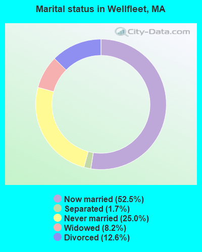
- Never married: 25.0%
- Now married: 52.5%
- Separated: 1.7%
- Widowed: 8.2%
- Divorced: 12.6%
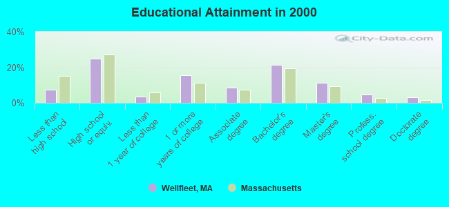
For population 25 years and over in Wellfleet:
- High school or higher: 92.7%
- Bachelor's degree or higher: 40.3%
- Graduate or professional degree: 19.0%
- Unemployed: 7.6%
- Mean travel time to work (commute): 20.7 minutes
| Here: | 11.2 |
| Massachusetts average: | 13.1 |
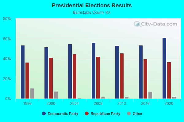
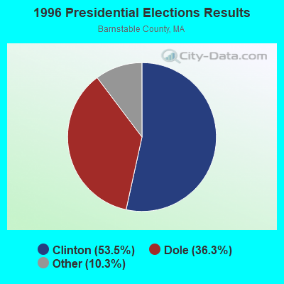
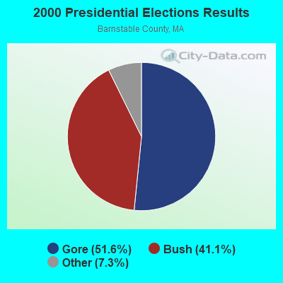


Graphs represent county-level data. Detailed 2008 Election Results
Religion statistics for Wellfleet, MA (based on Barnstable County data)
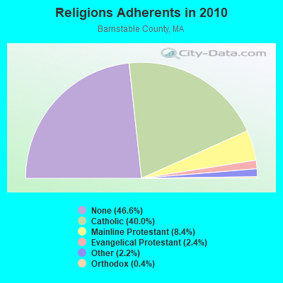
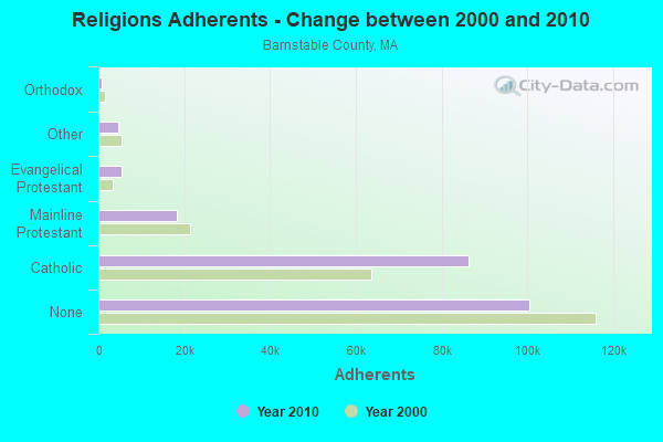
| Religion | Adherents | Congregations |
|---|---|---|
| Catholic | 86,370 | 18 |
| Mainline Protestant | 18,165 | 68 |
| Evangelical Protestant | 5,281 | 46 |
| Other | 4,734 | 32 |
| Orthodox | 810 | 3 |
| None | 100,528 | - |
Food Environment Statistics:
| Barnstable County: | 3.06 / 10,000 pop. |
| State: | 1.98 / 10,000 pop. |
| Barnstable County: | 0.05 / 10,000 pop. |
| Massachusetts: | 0.05 / 10,000 pop. |
| Barnstable County: | 3.38 / 10,000 pop. |
| Massachusetts: | 2.22 / 10,000 pop. |
| This county: | 2.57 / 10,000 pop. |
| Massachusetts: | 1.77 / 10,000 pop. |
| This county: | 18.60 / 10,000 pop. |
| State: | 8.76 / 10,000 pop. |
| Barnstable County: | 7.9% |
| Massachusetts: | 8.1% |
| Barnstable County: | 19.6% |
| State: | 22.5% |
| Barnstable County: | 13.8% |
| Massachusetts: | 16.5% |
Businesses in Wellfleet, MA
- Dunkin Donuts: 1
- FedEx: 1
- MasterBrand Cabinets: 1
Strongest AM radio stations in Wellfleet:
- WBZ (1030 AM; 50 kW; BOSTON, MA; Owner: INFINITY BROADCASTING OPERATIONS, INC.)
- WRKO (680 AM; 50 kW; BOSTON, MA; Owner: ENTERCOM BOSTON LICENSE, LLC)
- WEEI (850 AM; 50 kW; BOSTON, MA; Owner: ENTERCOM BOSTON LICENSE, LLC)
- WFPB (1170 AM; daytime; 1 kW; ORLEANS, MA; Owner: UNIVERSITY OF MASSACHUSETTS)
- WALE (990 AM; 50 kW; GREENVILLE, RI; Owner: NORTH AMERICAN BROADCASTING CO., INC.)
- WWZN (1510 AM; 50 kW; BOSTON, MA; Owner: ROSE CITY RADIO CORPORATION)
- WKOX (1200 AM; 50 kW; FRAMINGHAM, MA; Owner: CAPSTAR TX LIMITED PARTNERSHIP)
- WBIX (1060 AM; 40 kW; NATICK, MA; Owner: LANGER BROADCASTING CORPORATION)
- WCRN (830 AM; 50 kW; WORCESTER, MA; Owner: CARTER BROADCASTING CORPORATION)
- WAMG (890 AM; 25 kW; DEDHAM, MA; Owner: MEGA COMMUNICATIONS OF DEDHAM LICENSEE, LLC)
- WRCA (1330 AM; 25 kW; WALTHAM, MA; Owner: WRCA LICENSE, LLC)
- WNNZ (640 AM; 50 kW; WESTFIELD, MA; Owner: CLEAR CHANNEL BROADCASTING LICENSES, INC.)
- WUNR (1600 AM; 20 kW; BROOKLINE, MA; Owner: CHAMPION BROADCASTING SYSTEMS, INC.)
Strongest FM radio stations in Wellfleet:
- WKPE-FM (104.7 FM; ORLEANS, MA; Owner: CRB WKPE LIC CORP.)
- WCDJ (102.3 FM; TRURO, MA; Owner: TRURO WIRELESS, INC.)
- WFCC-FM (107.5 FM; CHATHAM, MA; Owner: CHARLES RIVER B/CING WFCC LIC. CORP.)
- WCOD-FM (106.1 FM; HYANNIS, MA; Owner: BOCH BROADCASTING, L.P.)
- WDVT (93.5 FM; HARWICH PORT, MA; Owner: BOCH BROADCASTING, L.P.)
- WOCN-FM (103.9 FM; SOUTH YARMOUTH, MA; Owner: SANDAB COMMUNICATIONS LTD. PARTNERSHIP II)
- WPXC (102.9 FM; HYANNIS, MA; Owner: QANTUM OF CAPE COD LICENSE COMPANY, LLC)
- WXTK (95.1 FM; WEST YARMOUTH, MA; Owner: BOCH BROADCASTING LTD. PARTNERSHIP)
- WOMR (92.1 FM; PROVINCETOWN, MA; Owner: LOWER CAPE COMMUNICATIONS, INC.)
- WQRC (99.9 FM; BARNSTABLE, MA; Owner: SANDAB COMMUNICATION LTD. PNR/SHP II)
- WCCT-FM (90.3 FM; HARWICH, MA; Owner: CAPE COD REGIONAL TECH HIGH SCHOOL)
TV broadcast stations around Wellfleet:
- W08CH (Channel 8; HYANNIS, MA; Owner: WGBH EDUCATIONAL FOUNDATION)
- WDPX (Channel 58; VINEYARD HAVEN, MA; Owner: PAXSON BOSTON-68 LICENSE, INC.)
- WMPX-LP (Channel 67; DENNIS, MA; Owner: PAXSON BOSTON-68 LICENSE, INC.)
- National Bridge Inventory (NBI) Statistics
- 3Number of bridges
- 26ft / 7.9mTotal length
- $8,030,000Total costs
- 1,625Total average daily traffic
- 95Total average daily truck traffic
- 4,423Total future (year 2031) average daily traffic
FCC Registered Broadcast Land Mobile Towers:
10 (See the full list of FCC Registered Broadcast Land Mobile Towers in Wellfleet, MA)FCC Registered Microwave Towers:
4- BS23XC754, 2381 Old Kings Hwy (Lat: 41.947167 Lon: -70.017389), Type: Pole, Structure height: 42.7 m, Overall height: 43 m, Call Sign: WQPU658,
Assigned Frequencies: 11175.0 MHz, 11175.0 MHz, 11175.0 MHz, Grant Date: 08/20/2012, Expiration Date: 08/20/2022, Cancellation Date: 08/15/2022, Certifier: David Werblow, Registrant: Dla Piper LLP, 500 8th Street, Nw, Washington, DC 20004, Phone: (202) 799-4216, Fax: (202) 799-5616, Email:
- Wellfleet WT, 158 Long Pond Road (Lat: 41.942361 Lon: -70.021083), Type: Tank, Structure height: 39.6 m, Call Sign: WQPX474,
Assigned Frequencies: 10735.0 MHz, 10775.0 MHz, 10935.0 MHz, 10975.0 MHz, 10735.0 MHz, 10775.0 MHz, 10935.0 MHz, 10975.0 MHz, 10735.0 MHz, 10775.0 MHz... (+38 more), Grant Date: 09/10/2012, Expiration Date: 09/10/2022, Cancellation Date: 11/12/2022, Certifier: Dan Gallagher, Registrant: Radyn, Inc, Silver Spring, MD 20914, Phone: (301) 493-5171, Fax: (301) 576-4553, Email:
- Wellfleet WT, 158 Long Pond Road (Lat: 41.942361 Lon: -70.021083), Type: Tank, Structure height: 39.6 m, Call Sign: WRXN850, Licensee ID: L01721556,
Assigned Frequencies: 10735.0 MHz, 10775.0 MHz, 10935.0 MHz, 10975.0 MHz, 10735.0 MHz, 10775.0 MHz, 10935.0 MHz, 10975.0 MHz, 10735.0 MHz, 10775.0 MHz... (+38 more), Grant Date: 06/05/2023, Expiration Date: 06/05/2033, Certifier: Jennifer Brann, Registrant: Opencape Corporation, 3195 Main Street, Barnstable, MA 02630, Phone: (508) 362-2224, Fax: (508) 362-0454, Email:
- STATION, Sub Station Gross Hill Rd (Lat: 41.947306 Lon: -70.017500), Overall height: 36 m, Call Sign: WIA287,
Assigned Frequencies: 2193.60 MHz, Grant Date: 07/15/1999, Expiration Date: 07/28/2009, Cancellation Date: 03/25/2008, Certifier: Lawrence J Gelbien, Registrant: Keller And Heckman LLP, 1001 G Street, Nw, Suite 500 West, Washington, DC 20001, Phone: (202) 434-4282, Fax: (202) 434-4646, Email:
FCC Registered Paging Towers:
1- Grosf Hill Road, (Lat: 41.947306 Lon: -70.017500), Call Sign: KNKO793,
Assigned Frequencies: 931.362 MHz, Expiration Date: 09/06/1995, Registrant: Firstpage Usa Of Virginia, Inc. Dba: First Page, 6422 Grovedale Court, Alexandria, VA 22310-0000
FCC Registered Maritime Coast & Aviation Ground Towers:
1- Town Pier Kendrick Av And Commercial St (Lat: 41.930139 Lon: -70.028222), Type: Building, Structure height: 6.8 m, Overall height: 8.6 m, Call Sign: WPUJ554, Licensee ID: L00045105,
Assigned Frequencies: 156.450 MHz, 156.600 MHz, 156.800 MHz, Grant Date: 01/11/2012, Expiration Date: 03/18/2022, Cancellation Date: 05/21/2022, Certifier: Michael J Flanagan, Registrant: Town Of Wellfleet Marina, 300 Main St, Wellfleet, MA 02667, Phone: (508) 349-0320, Fax: (508) 349-0320, Email:
FCC Registered Amateur Radio Licenses:
23 (See the full list of FCC Registered Amateur Radio Licenses in Wellfleet)FAA Registered Aircraft:
1- Aircraft: PIPER PA-28-180 (Category: Land, Seats: 4, Weight: Up to 12,499 Pounds, Speed: 107 mph), Engine: LYCOMING O&VO-360 SER (180 HP) (Reciprocating)
N-Number: 4845L, N4845L, N-4845L, Serial Number: 28-4378, Year manufactured: 1967, Airworthiness Date: 06/30/1967, Certificate Issue Date: 01/09/1969
Registrant (Individual): Gerald Feil, Box 283, Wellfleet, MA 02667
2002 - 2018 National Fire Incident Reporting System (NFIRS) incidents
- Fire incident types reported to NFIRS in Wellfleet, MA
- 23953.8%Structure Fires
- 14232.0%Outside Fires
- 4510.1%Mobile Property/Vehicle Fires
- 184.1%Other
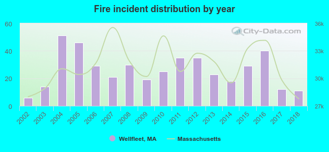 According to the data from the years 2002 - 2018 the average number of fire incidents per year is 26. The highest number of reported fire incidents - 51 took place in 2004, and the least - 6 in 2002. The data has a rising trend.
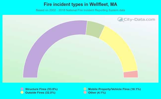 When looking into fire subcategories, the most incidents belonged to: Structure Fires (53.8%), and Outside Fires (32.0%).
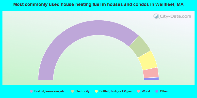
- 73.4%Fuel oil, kerosene, etc.
- 10.1%Electricity
- 9.6%Bottled, tank, or LP gas
- 5.4%Wood
- 1.1%Utility gas
- 0.4%Coal or coke
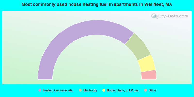
- 71.5%Fuel oil, kerosene, etc.
- 14.8%Electricity
- 8.5%Bottled, tank, or LP gas
- 2.0%Coal or coke
- 1.6%Wood
- 1.6%No fuel used
Wellfleet compared to Massachusetts state average:
- Median house value above state average.
- Unemployed percentage below state average.
- Black race population percentage significantly below state average.
- Hispanic race population percentage significantly below state average.
- Median age significantly above state average.
- Foreign-born population percentage significantly below state average.
- Renting percentage below state average.
- Length of stay since moving in significantly above state average.
- Number of rooms per house significantly below state average.
- House age significantly below state average.
- Number of college students below state average.

|
Total of 4 patent applications in 2008-2024.