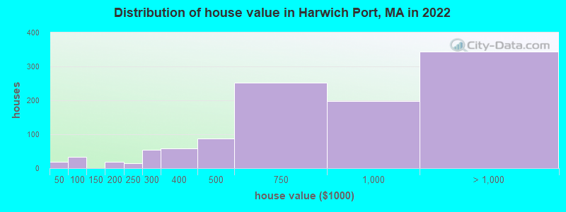
Estimated median house or condo value in 2022: $738,942 (it was $242,000 in 2000)
Harwich Port:
$738,942
MA:
$534,700
Mean prices in 2022:all housing units: $623,757; detached houses: $648,447; townhouses or other attached units: $490,502; in 2-unit structures: $577,155; in 3-to-4-unit structures: $445,551; in 5-or-more-unit structures: $351,307; mobile homes: $108,058
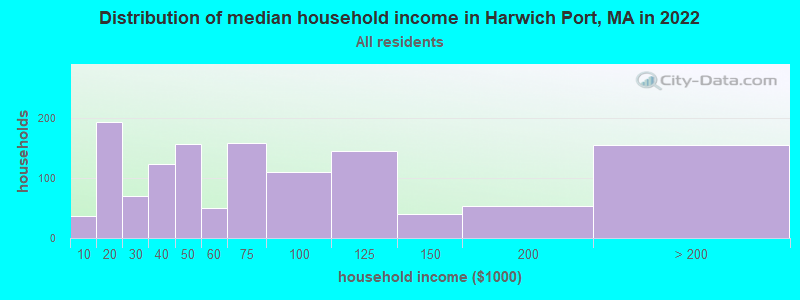
Median gross rent in 2022: $1,113.
March 2022 cost of living index in Harwich Port: 122.3 (high, U.S. average is 100)
Percentage of residents living in poverty in 2022: 8.9%
(8.4% for White Non-Hispanic residents, 60.9% for Black residents, 10.8% for Hispanic or Latino residents)
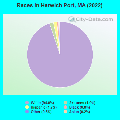
Ancestries: Irish (30.5%), American (12.5%), Polish (8.3%), English (6.1%), Lithuanian (4.3%), Italian (3.9%).
Current Local Time: EST time zone
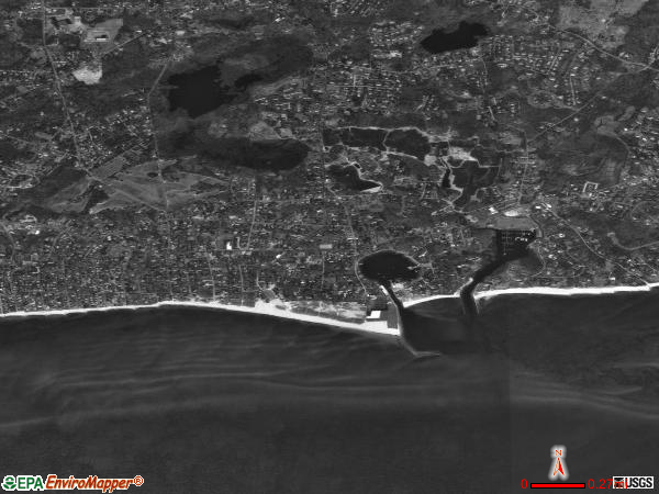
Elevation: 19 feet
Land area: 2.63 square miles.
Population density: 625 people per square mile (low).
91 residents are foreign born (1.8% Europe, 1.4% Latin America, 0.7% Asia).
This place:
4.0%
Massachusetts:
17.6%
Median real estate property taxes paid for housing units with mortgages in 2022: $4,738 (0.6%) Median real estate property taxes paid for housing units with no mortgage in 2022: $5,016 (0.7%)
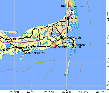
Nearest city with pop. 50,000+: New Bedford, MA (44.7 miles , pop. 93,768).
Nearest city with pop. 200,000+: Boston, MA (69.2 miles , pop. 589,141).
Nearest city with pop. 1,000,000+: Bronx, NY (205.8 miles , pop. 1,332,650).
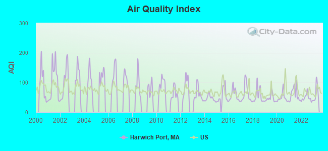
Air Quality Index (AQI) level in 2022 was 48.0. This is significantly better than average.
City:
48.0
U.S.:
72.6
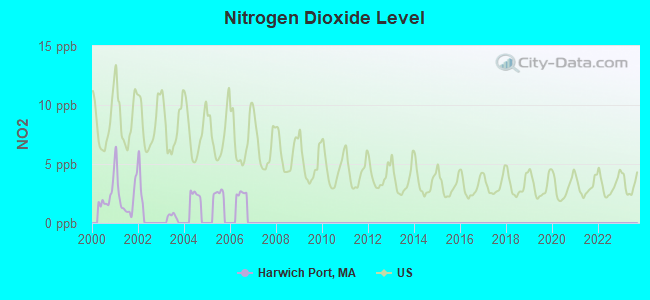
Nitrogen Dioxide (NO2) [ppb] level in 2001 was 2.30. This is significantly better than average.Closest monitor was 21.4 miles away from the city center.
City:
2.30
U.S.:
5.11
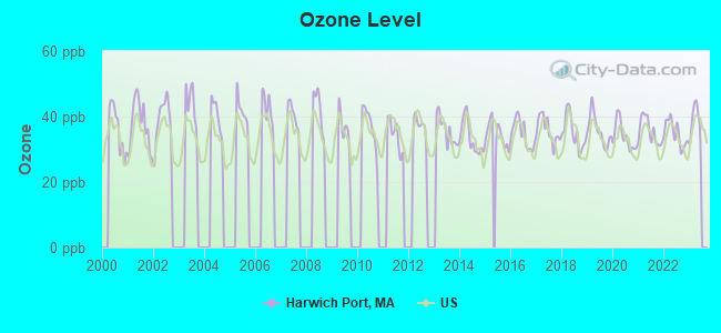
Ozone [ppb] level in 2022 was 34.8. This is about average.Closest monitor was 21.4 miles away from the city center.
City:
34.8
U.S.:
33.3
Earthquake activity:
Harwich Port-area historical earthquake activity is significantly above Massachusetts state average. It is 78% smaller than the overall U.S. average.
On 10/16/2012 at 23:12:25, a magnitude 4.7 (4.7 ML, Depth: 10.0 mi, Class: Light, Intensity: IV - V) earthquake occurred 136.7 miles away from the city center On 1/19/1982 at 00:14:42, a magnitude 4.7 (4.5 MB, 4.7 MD, 4.5 LG) earthquake occurred 148.8 miles away from Harwich Port center On 10/7/1983 at 10:18:46, a magnitude 5.3 (5.1 MB, 5.3 LG, 5.1 ML, Class: Moderate, Intensity: VI - VII) earthquake occurred 268.2 miles away from the city center On 4/20/2002 at 10:50:47, a magnitude 5.3 (5.3 ML, Depth: 3.0 mi) earthquake occurred 268.8 miles away from Harwich Port center On 8/22/1992 at 12:20:32, a magnitude 4.8 (4.8 MB, 3.8 MS, 4.7 LG, Depth: 6.2 mi) earthquake occurred 177.7 miles away from Harwich Port center On 4/20/2002 at 10:50:47, a magnitude 5.2 (5.2 MB, 4.2 MS, 5.2 MW, 5.0 MW) earthquake occurred 268.3 miles away from the city center Magnitude types: regional Lg-wave magnitude (LG), body-wave magnitude (MB), duration magnitude (MD), local magnitude (ML), surface-wave magnitude (MS), moment magnitude (MW)
Natural disasters:
The number of natural disasters in Barnstable County (21) is greater than the US average (15). Major Disasters (Presidential) Declared: 11 Emergencies Declared: 8
Causes of natural disasters: Hurricanes: 7, Floods: 5, Storms: 4, Snows: 3, Snowstorms: 3, Winter Storms: 3, Blizzards: 2, Snowfall: 1, Tropical Storm: 1, Wind: 1, Other: 1 (Note: some incidents may be assigned to more than one category).
Hospitals and medical centers near Harwich Port:
EPOCH SENIOR HEALTHCARE OF HARWICH (Nursing Home, about 3 miles away; HARWICH, MA)
HOSPICE OF VNA OF CEN AND OUTER CAPE COD (Hospital, about 5 miles away; SOUTH DENNIS, MA)
BREWSTER MANOR NURSING RET HOME (Nursing Home, about 5 miles away; BREWSTER, MA)
EPOCH SENIOR HEALTHCARE OF BREWSTER (Nursing Home, about 5 miles away; BREWSTER, MA)
BROAD REACH HOSPICE (Hospital, about 6 miles away; NORTH CHATHAM, MA)
LIBERTY COMMONS (Nursing Home, about 6 miles away; NORTH CHATHAM, MA)
WINDSOR NURSING AND RETIREMENT HOME (Nursing Home, about 6 miles away; SOUTH YARMOUTH, MA)
Colleges/universities with over 2000 students nearest to Harwich Port:
Cape Cod Community College (about 14 miles; West Barnstable, MA; Full-time enrollment: 2,491)
University of Massachusetts-Dartmouth (about 49 miles; North Dartmouth, MA; FT enrollment: 7,545)
Bridgewater State University (about 52 miles; Bridgewater, MA; FT enrollment: 9,802)
Bristol Community College (about 55 miles; Fall River, MA; FT enrollment: 5,707)
Massasoit Community College (about 56 miles; Brockton, MA; FT enrollment: 5,442)
Stonehill College (about 59 miles; Easton, MA; FT enrollment: 2,563)
Roger Williams University (about 62 miles; Bristol, RI; FT enrollment: 4,375)
Library in Harwich Port:
HARWICH PORT LIBRARY ASSOC. (Operating income: $33,393; Location: LOWER BANK ST.; 17,100 books; 55 audio materials; 203 video materials; 34 state licensed databases)
Hotels: Country Inn (86 Sisson Road), Dunscroft By The Sea (Ip) (24 Pilgrim Rd), Seadar Inn by the Sea (1 Braddock Lane), Sandpiper Beach Inn (16 Bank).
Barnstable County has a predicted average indoor radon screening level between 2 and 4 pCi/L (pico curies per liter) - Moderate Potential
Average household size:
This place:
1.7 people
Massachusetts:
2.5 people
Percentage of family households:
This place:
45.1%
Whole state:
63.0%
Percentage of households with unmarried partners:
This place:
4.0%
Whole state:
7.0%
Likely homosexual households (counted as self-reported same-sex unmarried-partner households)
Lesbian couples: 0.3% of all households
Gay men: 0.8% of all households
3 people in other noninstitutional facilities in 2010
12 people in other noninstitutional group quarters in 2000
5 people in nursing homes in 2000
Banks with branches in Harwich Port (2011 data):
TD Bank, National Association: Harwich Port Branch at 536 Main Street, branch established on 1964/05/01. Info updated 2010/10/04: Bank assets: $188,912.6 mil, Deposits: $153,149.8 mil, headquarters in Wilmington, DE, positive income, 1314 total offices, Holding Company: Toronto-Dominion Bank, The
The Cape Cod Five Cents Savings Bank: at 532 Main St., branch established on 1855/03/16. Info updated 2006/11/03: Bank assets: $2,106.5 mil, Deposits: $1,831.3 mil, local headquarters, positive income, Mortgage Lending Specialization, 17 total offices
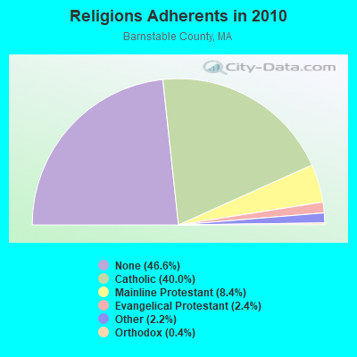
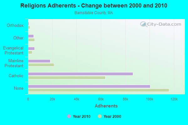
Religion statistics for Harwich Port, MA (based on Barnstable County data)
Religion
Adherents
Congregations
Catholic
86,370
18
Mainline Protestant
18,165
68
Evangelical Protestant
5,281
46
Other
4,734
32
Orthodox
810
3
None
100,528
-
Source: Clifford Grammich, Kirk Hadaway, Richard Houseal, Dale E.Jones, Alexei Krindatch, Richie Stanley and Richard H.Taylor. 2012. 2010 U.S.Religion Census: Religious Congregations & Membership Study. Association of Statisticians of American Religious Bodies. Jones, Dale E., et al. 2002. Congregations and Membership in the United States 2000. Nashville, TN: Glenmary Research Center. Graphs represent county-level data
Allen Harbor Yacht Club (Lat: 41.655667 Lon: -70.091139), Type: Building, Overall height: 9 m, Call Sign: KEB444, Licensee ID: L00790776, Assigned Frequencies: 156.425 MHz, 156.450 MHz, 156.800 MHz, Grant Date: 01/03/2004, Expiration Date: 03/08/2014, Cancellation Date: 05/10/2014, Registrant: Allen Harbor Yacht Club Inc, Harwich Port, MA 02646, Phone: (508) 432-4306
335 Lower Cr (Lat: 41.667333 Lon: -70.090583), Type: Tower, Call Sign: KTR891, Licensee ID: L00477257, Assigned Frequencies: 156.450 MHz, 156.425 MHz, 156.800 MHz, Grant Date: 03/14/2012, Expiration Date: 03/27/2022, Cancellation Date: 05/28/2022, Registrant: Allen Harbor Marine Service Inc, 335 Lower County Rd, Harwich Port, MA 02646, Phone: (508) 432-0353
702 Main St (Lat: 41.661222 Lon: -70.065861), Type: Building, Overall height: 12 m, Call Sign: KWS666, Licensee ID: L00694644, Assigned Frequencies: 156.450 MHz, 156.600 MHz, 156.800 MHz, Grant Date: 05/27/2004, Expiration Date: 07/21/2014, Cancellation Date: 09/20/2014, Registrant: Freedom Cruise Line Inc, 702 Main St, Harwich Port, MA 02646, Phone: (508) 432-8999
FCC Registered Amateur Radio Licenses:
6
Call Sign: KA1UHD, Grant Date: 05/26/1999, Expiration Date: 05/26/2009, Cancellation Date: 05/27/2011, Registrant: Arthur P Doane Jr, Harwich Port, MA 02646-0423
Call Sign: W1NC, Previous Call Sign: KQ1E, Licensee ID: L00504434, Grant Date: 08/10/2016, Expiration Date: 11/04/2026, Certifier: Jeffrey W Moore, Registrant: Jeffrey W Moore, 464 Route 28, Harwich Port, MA 02646
Call Sign: W2JJM, Licensee ID: L00175616, Grant Date: 05/02/2006, Expiration Date: 07/10/2016, Cancellation Date: 07/11/2018, Certifier: James Q Montress, Registrant: James Q Montress, 6 Doane Way, Harwich Port, MA 02646-1611
Call Sign: KB1JYC, Licensee ID: L00681998, Grant Date: 05/08/2003, Expiration Date: 05/08/2013, Cancellation Date: 05/09/2015, Certifier: Pieter A Stienstra, Registrant: Pieter A Stienstra, 371 Rt 28 Apt 10, Harwich Port, MA 02646
Call Sign: KC1JWQ, Licensee ID: L02193232, Grant Date: 06/12/2018, Expiration Date: 06/12/2028, Cancellation Date: 09/10/2018, Certifier: Thomas C Amirault, Registrant: Thomas C Amirault, 633 Main St (Route 28), Harwich Port, MA 02646
Call Sign: AC1FW, Previous Call Sign: KC1JWQ, Licensee ID: L02193232, Grant Date: 06/12/2018, Expiration Date: 06/12/2028, Cancellation Date: 10/02/2018, Certifier: Thomas C Amirault, Registrant: Thomas C Amirault, 633 Main St (Route 28), Harwich Port, MA 02646
FAA Registered Aircraft:
2
Aircraft: CESSNA 310Q (Category: Land, Engines: 2, Seats: 6, Weight: Up to 12,499 Pounds, Speed: 167 mph), Engine: CONT MOTOR I0-470 SERIES (260 HP) (Reciprocating) N-Number: 6277Q, N6277Q, N-6277Q, Serial Number: 310Q0747, Year manufactured: 1973, Airworthiness Date: 05/16/1973, Certificate Issue Date: 01/14/2020 Registrant (Individual): Gavin J Archibald, 8 Atlantic Ave, Harwich Port, MA 02646
Aircraft: ROBINSON HELICOPTER R44 (Category: Land, Seats: 4, Weight: Up to 12,499 Pounds), Engine: LYCOMING O-540-F1B5 (260 HP) (Reciprocating) N-Number: 808WT, N808WT, N-808WT, Serial Number: 1990, Year manufactured: 2008, Airworthiness Date: 10/30/2008 Registrant (Individual): Pending Registration, 21 Ocean Ave, Harwich Port, MA 02646
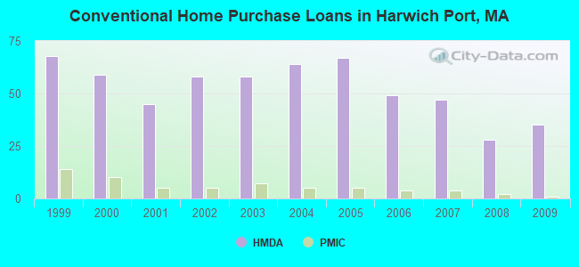
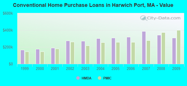
Home Mortgage Disclosure Act Aggregated Statistics For Year 2009 (Based on 1 partial tract)
A) FHA, FSA/RHS & VA Home Purchase Loans
B) Conventional Home Purchase Loans
C) Refinancings
D) Home Improvement Loans
F) Non-occupant Loans on < 5 Family Dwellings (A B C & D)
Number
Average Value
Number
Average Value
Number
Average Value
Number
Average Value
Number
Average Value
LOANS ORIGINATED
1
$130,280
35
$309,385
127
$275,108
6
$224,593
97
$329,389
APPLICATIONS APPROVED, NOT ACCEPTED
0
$0
2
$213,390
7
$247,449
1
$52,110
5
$284,730
APPLICATIONS DENIED
1
$94,320
4
$361,252
24
$314,245
4
$100,050
13
$323,042
APPLICATIONS WITHDRAWN
1
$281,390
3
$351,570
16
$243,744
1
$38,560
10
$314,536
FILES CLOSED FOR INCOMPLETENESS
0
$0
2
$472,900
3
$389,263
0
$0
2
$306,405
Aggregated Statistics For Year 2008 (Based on 1 partial tract)
A) FHA, FSA/RHS & VA Home Purchase Loans
B) Conventional Home Purchase Loans
C) Refinancings
D) Home Improvement Loans
F) Non-occupant Loans on < 5 Family Dwellings (A B C & D)
Number
Average Value
Number
Average Value
Number
Average Value
Number
Average Value
Number
Average Value
LOANS ORIGINATED
1
$242,830
28
$341,544
57
$338,788
7
$242,163
51
$407,367
APPLICATIONS APPROVED, NOT ACCEPTED
0
$0
2
$765,235
5
$625,736
1
$215,210
5
$760,390
APPLICATIONS DENIED
0
$0
4
$223,030
23
$416,993
2
$36,215
9
$406,806
APPLICATIONS WITHDRAWN
0
$0
2
$340,540
8
$447,495
0
$0
4
$484,752
FILES CLOSED FOR INCOMPLETENESS
0
$0
1
$234,500
2
$204,790
0
$0
0
$0
Aggregated Statistics For Year 2007 (Based on 1 partial tract)
A) FHA, FSA/RHS & VA Home Purchase Loans
B) Conventional Home Purchase Loans
C) Refinancings
D) Home Improvement Loans
F) Non-occupant Loans on < 5 Family Dwellings (A B C & D)
Number
Average Value
Number
Average Value
Number
Average Value
Number
Average Value
Number
Average Value
LOANS ORIGINATED
1
$129,750
47
$385,237
61
$337,365
9
$300,328
52
$401,067
APPLICATIONS APPROVED, NOT ACCEPTED
0
$0
4
$430,038
8
$459,740
1
$187,600
5
$536,628
APPLICATIONS DENIED
0
$0
6
$263,242
44
$365,433
7
$236,580
15
$383,773
APPLICATIONS WITHDRAWN
0
$0
4
$482,800
12
$352,568
1
$381,970
4
$468,078
FILES CLOSED FOR INCOMPLETENESS
0
$0
1
$45,860
6
$287,040
1
$194,890
0
$0
Aggregated Statistics For Year 2006 (Based on 1 partial tract)
A) FHA, FSA/RHS & VA Home Purchase Loans
B) Conventional Home Purchase Loans
C) Refinancings
D) Home Improvement Loans
F) Non-occupant Loans on < 5 Family Dwellings (A B C & D)
Number
Average Value
Number
Average Value
Number
Average Value
Number
Average Value
Number
Average Value
LOANS ORIGINATED
2
$236,840
49
$317,616
93
$290,410
22
$181,651
54
$345,750
APPLICATIONS APPROVED, NOT ACCEPTED
0
$0
2
$216,515
7
$188,117
3
$107,867
4
$219,382
APPLICATIONS DENIED
0
$0
4
$381,445
30
$264,041
4
$80,640
8
$391,868
APPLICATIONS WITHDRAWN
0
$0
6
$213,738
18
$287,763
1
$58,880
8
$305,820
FILES CLOSED FOR INCOMPLETENESS
0
$0
0
$0
3
$321,520
1
$26,060
1
$307,450
Aggregated Statistics For Year 2005 (Based on 1 partial tract)
B) Conventional Home Purchase Loans
C) Refinancings
D) Home Improvement Loans
E) Loans on Dwellings For 5+ Families
F) Non-occupant Loans on < 5 Family Dwellings (A B C & D)
G) Loans On Manufactured Home Dwelling (A B C & D)
Number
Average Value
Number
Average Value
Number
Average Value
Number
Average Value
Number
Average Value
Number
Average Value
LOANS ORIGINATED
67
$309,969
85
$253,960
12
$165,797
1
$697,230
63
$331,130
0
$0
APPLICATIONS APPROVED, NOT ACCEPTED
4
$251,170
6
$198,713
3
$64,790
0
$0
4
$205,705
0
$0
APPLICATIONS DENIED
7
$233,974
20
$224,438
6
$171,790
1
$495,050
5
$251,692
1
$36,480
APPLICATIONS WITHDRAWN
5
$228,242
28
$241,251
4
$196,715
0
$0
6
$251,430
0
$0
FILES CLOSED FOR INCOMPLETENESS
1
$304,840
4
$293,118
1
$28,660
0
$0
1
$303,800
0
$0
Aggregated Statistics For Year 2004 (Based on 1 partial tract)
B) Conventional Home Purchase Loans
C) Refinancings
D) Home Improvement Loans
E) Loans on Dwellings For 5+ Families
F) Non-occupant Loans on < 5 Family Dwellings (A B C & D)
Number
Average Value
Number
Average Value
Number
Average Value
Number
Average Value
Number
Average Value
LOANS ORIGINATED
64
$300,080
105
$231,602
16
$183,069
1
$125,060
69
$289,294
APPLICATIONS APPROVED, NOT ACCEPTED
2
$294,160
9
$174,048
2
$133,925
0
$0
4
$261,723
APPLICATIONS DENIED
7
$252,139
21
$319,906
7
$114,493
1
$390,820
7
$376,086
APPLICATIONS WITHDRAWN
4
$165,580
33
$208,961
1
$59,930
0
$0
3
$174,743
FILES CLOSED FOR INCOMPLETENESS
2
$242,050
2
$222,770
0
$0
0
$0
2
$354,085
Aggregated Statistics For Year 2003 (Based on 1 partial tract)
A) FHA, FSA/RHS & VA Home Purchase Loans
B) Conventional Home Purchase Loans
C) Refinancings
D) Home Improvement Loans
F) Non-occupant Loans on < 5 Family Dwellings (A B C & D)
Number
Average Value
Number
Average Value
Number
Average Value
Number
Average Value
Number
Average Value
LOANS ORIGINATED
0
$0
58
$270,990
253
$204,961
3
$102,830
117
$248,765
APPLICATIONS APPROVED, NOT ACCEPTED
0
$0
3
$166,403
15
$209,656
0
$0
7
$199,953
APPLICATIONS DENIED
0
$0
5
$250,650
19
$216,668
2
$67,480
5
$276,392
APPLICATIONS WITHDRAWN
1
$96,920
5
$319,956
27
$208,556
1
$26,060
4
$394,732
FILES CLOSED FOR INCOMPLETENESS
0
$0
1
$312,660
4
$177,042
0
$0
1
$53,670
Aggregated Statistics For Year 2002 (Based on 1 partial tract)
A) FHA, FSA/RHS & VA Home Purchase Loans
B) Conventional Home Purchase Loans
C) Refinancings
D) Home Improvement Loans
F) Non-occupant Loans on < 5 Family Dwellings (A B C & D)
Number
Average Value
Number
Average Value
Number
Average Value
Number
Average Value
Number
Average Value
LOANS ORIGINATED
0
$0
58
$273,757
182
$186,866
7
$53,599
96
$251,013
APPLICATIONS APPROVED, NOT ACCEPTED
0
$0
6
$237,100
12
$180,561
2
$42,990
5
$247,836
APPLICATIONS DENIED
0
$0
4
$138,092
18
$216,836
3
$36,997
3
$248,043
APPLICATIONS WITHDRAWN
0
$0
3
$199,930
19
$177,859
2
$63,835
4
$349,008
FILES CLOSED FOR INCOMPLETENESS
1
$74,520
2
$227,720
1
$232,410
0
$0
0
$0
Aggregated Statistics For Year 2001 (Based on 1 partial tract)
B) Conventional Home Purchase Loans
C) Refinancings
D) Home Improvement Loans
F) Non-occupant Loans on < 5 Family Dwellings (A B C & D)
Number
Average Value
Number
Average Value
Number
Average Value
Number
Average Value
LOANS ORIGINATED
45
$189,009
119
$183,957
6
$29,008
53
$218,351
APPLICATIONS APPROVED, NOT ACCEPTED
6
$118,810
16
$183,818
3
$30,743
5
$230,118
APPLICATIONS DENIED
3
$191,417
15
$198,747
5
$42,834
5
$152,370
APPLICATIONS WITHDRAWN
3
$201,143
15
$112,835
2
$23,450
2
$141,480
FILES CLOSED FOR INCOMPLETENESS
1
$328,290
4
$252,342
0
$0
1
$192,810
Aggregated Statistics For Year 2000 (Based on 1 partial tract)
A) FHA, FSA/RHS & VA Home Purchase Loans
B) Conventional Home Purchase Loans
C) Refinancings
D) Home Improvement Loans
E) Loans on Dwellings For 5+ Families
F) Non-occupant Loans on < 5 Family Dwellings (A B C & D)
Number
Average Value
Number
Average Value
Number
Average Value
Number
Average Value
Number
Average Value
Number
Average Value
LOANS ORIGINATED
1
$155,810
59
$175,929
42
$135,412
4
$24,492
1
$364,770
29
$186,518
APPLICATIONS APPROVED, NOT ACCEPTED
0
$0
5
$205,626
6
$89,630
2
$20,845
0
$0
1
$10,420
APPLICATIONS DENIED
1
$104,220
7
$148,737
19
$102,300
7
$33,424
0
$0
3
$187,423
APPLICATIONS WITHDRAWN
1
$37,000
3
$360,773
13
$100,933
2
$31,005
0
$0
2
$139,395
FILES CLOSED FOR INCOMPLETENESS
0
$0
1
$37,520
1
$294,420
0
$0
0
$0
1
$208,440
Aggregated Statistics For Year 1999 (Based on 1 partial tract)
A) FHA, FSA/RHS & VA Home Purchase Loans
B) Conventional Home Purchase Loans
C) Refinancings
D) Home Improvement Loans
F) Non-occupant Loans on < 5 Family Dwellings (A B C & D)


 Recent articles from our blog. Our writers, many of them Ph.D. graduates or candidates, create easy-to-read articles on a wide variety of topics.

 (44.7 miles