Helmville, Montana
Submit your own pictures of this place and show them to the world
- OSM Map
- General Map
- Google Map
- MSN Map

| Males: 268 | |
| Females: 242 |
| Median resident age: | 42.4 years |
| Montana median age: | 37.5 years |
Zip code: 59854
| Helmville: | $55,202 |
| MT: | $67,631 |
Estimated per capita income in 2022: $30,379 (it was $13,962 in 2000)
Helmville CCD income, earnings, and wages data
Estimated median house or condo value in 2022: $488,869 (it was $136,800 in 2000)
| Helmville: | $488,869 |
| MT: | $366,400 |
Mean prices in 2022: all housing units: $360,380; detached houses: $368,022; mobile homes: $237,526
Detailed information about poverty and poor residents in Helmville, MT
Compare current foreclosures near Helmville, MT:
| Photo | Address | Area | Beds / Baths | Price | Details |
|---|---|---|---|---|---|

|
#1
Westfork Rattler Gulch Rd
Drummond, MT 59832
|
- sq. feet
|
- baths - beds |
show details | |

|
Check over 1 million property listings on Foreclosure.com!
|
browse all offers | |||

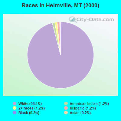
- 49596.1%White alone
- 61.2%American Indian alone
- 61.2%Two or more races
- 61.2%Hispanic
- 10.2%Black alone
- 10.2%Asian alone
Races in Helmville detailed stats: ancestries, foreign born residents, place of birth
According to our research of Montana and other state lists, there was 1 registered sex offender living in Helmville, Montana as of May 15, 2024.
The ratio of all residents to sex offenders in Helmville is 510 to 1.
The ratio of registered sex offenders to all residents in this city is lower than the state average.
 Recent articles from our blog. Our writers, many of them Ph.D. graduates or candidates, create easy-to-read articles on a wide variety of topics.
Current Local Time: MST time zone
Elevation: 4306 feet
Land area: 1266.5 square miles.
Population density: 0.4 people per square mile (very low).

| Helmville CCD: | 0.5% ($725) |
| Montana: | 1.3% ($1,212) |
Nearest city with pop. 50,000+: Missoula, MT  (45.3 miles , pop. 57,053).
Nearest city with pop. 200,000+: East Seattle, WA (429.3 miles , pop. 480,100).
Nearest city with pop. 1,000,000+: Phoenix, AZ (930.1 miles , pop. 1,321,045).
Nearest cities:
), Latitude: 46.95 N, Longitude: 113.06 W
Area code commonly used in this area: 406

| Here: | 3.4% |
| Montana: | 3.8% |
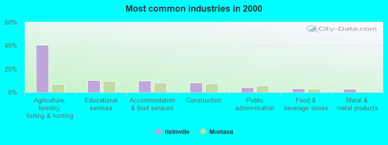
- Agriculture, forestry, fishing & hunting (40.5%)
- Educational services (10.5%)
- Accommodation & food services (10.0%)
- Construction (8.1%)
- Public administration (4.3%)
- Food & beverage stores (3.3%)
- Metal & metal products (2.9%)
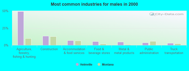
- Agriculture, forestry, fishing & hunting (49.2%)
- Construction (13.3%)
- Accommodation & food services (7.0%)
- Food & beverage stores (5.5%)
- Metal & metal products (4.7%)
- Public administration (3.9%)
- Truck transportation (3.1%)
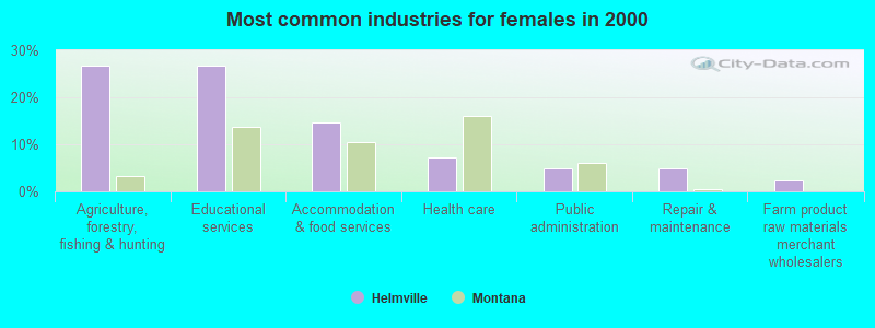
- Agriculture, forestry, fishing & hunting (26.8%)
- Educational services (26.8%)
- Accommodation & food services (14.6%)
- Health care (7.3%)
- Public administration (4.9%)
- Repair & maintenance (4.9%)
- Farm product raw materials merchant wholesalers (2.4%)
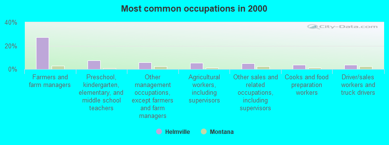
- Farmers and farm managers (27.1%)
- Preschool, kindergarten, elementary, and middle school teachers (7.6%)
- Other management occupations, except farmers and farm managers (5.7%)
- Agricultural workers, including supervisors (5.2%)
- Other sales and related occupations, including supervisors (4.8%)
- Cooks and food preparation workers (3.8%)
- Driver/sales workers and truck drivers (3.8%)
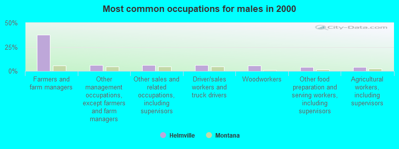
- Farmers and farm managers (37.5%)
- Other management occupations, except farmers and farm managers (6.2%)
- Other sales and related occupations, including supervisors (6.2%)
- Driver/sales workers and truck drivers (6.2%)
- Woodworkers (5.5%)
- Other food preparation and serving workers, including supervisors (3.9%)
- Agricultural workers, including supervisors (3.9%)
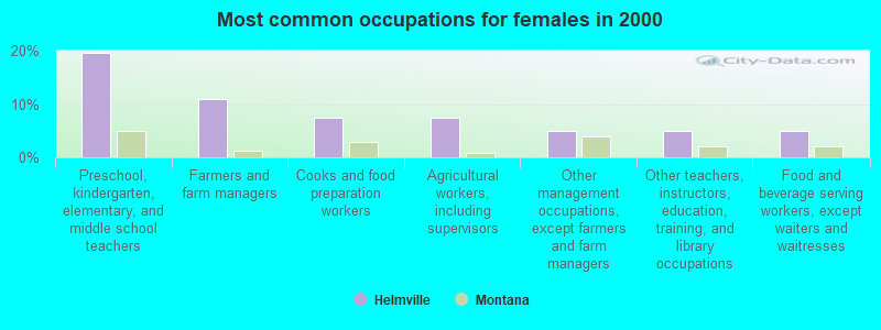
- Preschool, kindergarten, elementary, and middle school teachers (19.5%)
- Farmers and farm managers (11.0%)
- Cooks and food preparation workers (7.3%)
- Agricultural workers, including supervisors (7.3%)
- Other management occupations, except farmers and farm managers (4.9%)
- Other teachers, instructors, education, training, and library occupations (4.9%)
- Food and beverage serving workers, except waiters and waitresses (4.9%)
Average climate in Helmville, Montana
Based on data reported by over 4,000 weather stations


(lower is better)
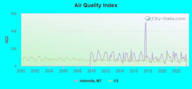
Air Quality Index (AQI) level in 2022 was 88.1. This is worse than average.
| City: | 88.1 |
| U.S.: | 72.6 |
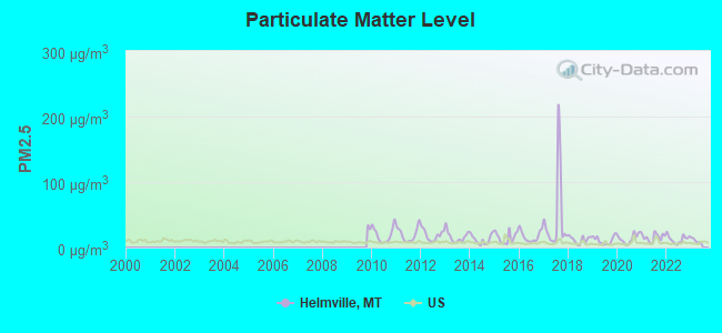
Particulate Matter (PM2.5) [µg/m3] level in 2022 was 12.7. This is significantly worse than average. Closest monitor was 17.2 miles away from the city center.
| City: | 12.7 |
| U.S.: | 8.1 |
Earthquake activity:
Helmville-area historical earthquake activity is significantly above Montana state average. It is 896% greater than the overall U.S. average.On 8/18/1959 at 06:37:13, a magnitude 7.7 (7.7 UK, Class: Major, Intensity: VIII - XII) earthquake occurred 201.9 miles away from the city center, causing $26,000,000 total damage
On 10/28/1983 at 14:06:06, a magnitude 7.3 (6.2 MB, 7.3 MS, 7.0 MW) earthquake occurred 202.2 miles away from the city center, causing 2 deaths (2 shaking deaths) and 3 injuries, causing $15,000,000 total damage
On 7/6/2017 at 06:30:17, a magnitude 5.8 (5.8 MW, Depth: 7.6 mi, Class: Moderate, Intensity: VI - VII) earthquake occurred 23.6 miles away from Helmville center
On 3/31/2020 at 23:52:30, a magnitude 6.5 (6.5 MW, Depth: 7.5 mi, Class: Strong, Intensity: VII - IX) earthquake occurred 198.7 miles away from Helmville center
On 6/30/1975 at 18:54:13, a magnitude 6.1 (5.6 MB, 5.9 MS, 6.1 UK, 6.1 ML) earthquake occurred 193.5 miles away from the city center
On 7/26/2005 at 04:08:37, a magnitude 5.7 (5.7 MB, 5.2 MS, 5.6 MW) earthquake occurred 110.2 miles away from Helmville center
Magnitude types: body-wave magnitude (MB), local magnitude (ML), surface-wave magnitude (MS), moment magnitude (MW)
Natural disasters:
The number of natural disasters in Powell County (11) is smaller than the US average (15).Major Disasters (Presidential) Declared: 6
Emergencies Declared: 1
Causes of natural disasters: Floods: 5, Storms: 4, Fires: 3, Heavy Rain: 1, Hurricane: 1, Landslide: 1, Snow: 1, Other: 1 (Note: some incidents may be assigned to more than one category).
Colleges/universities with over 2000 students nearest to Helmville:
- The University of Montana (about 44 miles; Missoula, MT; Full-time enrollment: 13,602)
- Montana State University (about 132 miles; Bozeman, MT; FT enrollment: 12,942)
- North Idaho College (about 183 miles; Coeur d'Alene, ID; FT enrollment: 4,684)
- University of Idaho (about 189 miles; Moscow, ID; FT enrollment: 10,416)
- Lewis-Clark State College (about 192 miles; Lewiston, ID; FT enrollment: 3,199)
- Washington State University (about 195 miles; Pullman, WA; FT enrollment: 25,055)
- Spokane Community College (about 208 miles; Spokane, WA; FT enrollment: 6,482)
Public elementary/middle school in Helmville:
- HELMVILLE SCHOOL (Students: 34, Location: 201 SCHOOLHOUSE RD, Grades: PK-8)
Points of interest:
Notable locations in Helmville: Manley Ranch (A), Monture Creek Recreation Site (B), Old Boyd Ranch (C), Mineral Hill Sportsmans Access (D), Basin Creek Guard Station (E), Hahn Creek Guard Station (F), Holbrook Guard Station (G), Shaw Creek Guard Station (H), Blackfoot Canyon Campground (I), Big Nelson Campground (J), Monture Creek Campground (K), Monture Creek Guard Station (L), Monture Hereford Ranch (M), Morrell Lookout (N), Murphy Ranch (O), Cedar Meadow Fishing Access Site (P), Aunt Molly Fishing Access Site (Q), Lincoln Canyon Fishing Access Site (R), Browns Lake Fishing Access Site (S), Harry Morgan Fishing Access Site (T). Display/hide their locations on the map
Churches in Helmville include: Helmville Community Fellowship (A), Saint Thomas the Apostle Church (B), Blackfoot Church (C). Display/hide their locations on the map
Cemeteries: Helmville Cemetery (1), Saint Thomas Cemetery (2), Ovando Cemetery (3). Display/hide their locations on the map
Lakes, reservoirs, and swamps: Rice Lake (A), Reservoir Lake (B), Spawn Lake (C), Upsata Lake (D), Chimney Lakes (E), Otis Lake (F), Big Knife Lakes (G), Deadmans Lake (H). Display/hide their locations on the map
Streams, rivers, and creeks: Lost Creek (A), Babcock Creek (B), Bartlett Creek (C), Bill Creek (D), Black Canyon Creek (E), Blind Canyon Creek (F), Boulder Creek (G), Braziel Creek (H), Brownie Creek (I). Display/hide their locations on the map
Parks in Helmville include: Cottonwood Park (1), Copenhaver Park (2). Display/hide their locations on the map
| This place: | 2.1 people |
| Montana: | 2.4 people |
| This place: | 68.2% |
| Whole state: | 62.8% |
| This place: | 3.3% |
| Whole state: | 6.7% |
Likely homosexual households (counted as self-reported same-sex unmarried-partner households)
- Lesbian couples: 0.0% of all households
- Gay men: 0.4% of all households
| This place: | 18.9% |
| Whole state: | 14.6% |
| This place: | 6.0% |
| Whole state: | 5.8% |
For population 15 years and over in Helmville:
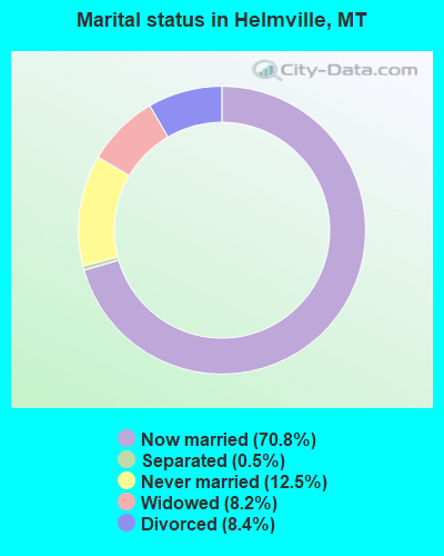
- Never married: 12.5%
- Now married: 70.8%
- Separated: 0.5%
- Widowed: 8.2%
- Divorced: 8.4%
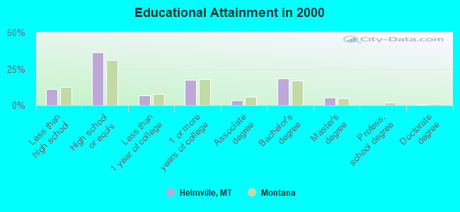
For population 25 years and over in Helmville:
- High school or higher: 88.9%
- Bachelor's degree or higher: 24.7%
- Graduate or professional degree: 6.1%
- Unemployed: 5.4%
- Mean travel time to work (commute): 17.1 minutes
| Here: | 10.4 |
| Montana average: | 10.4 |
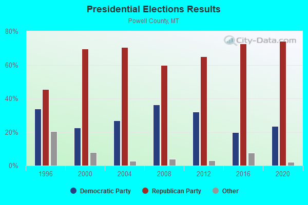
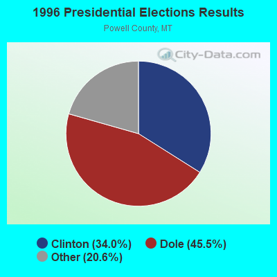
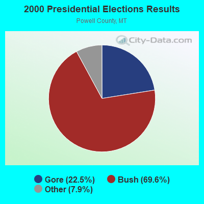
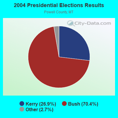
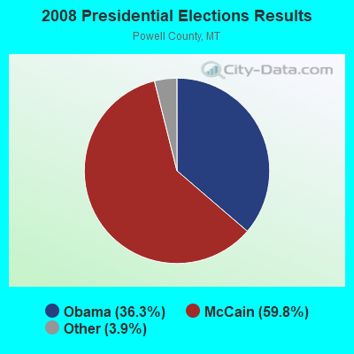
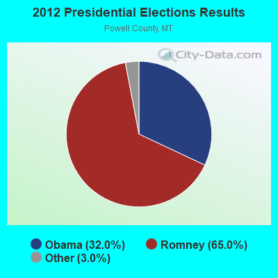

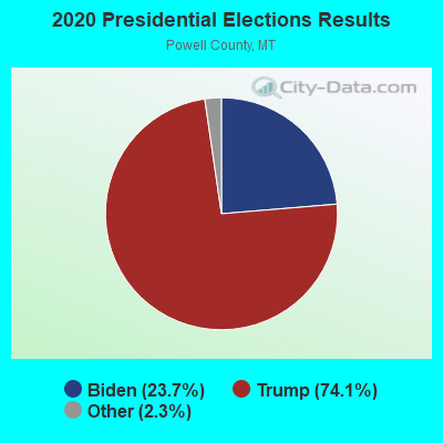
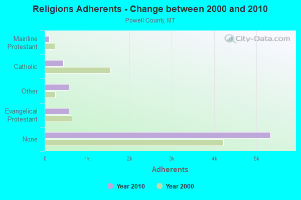
Graphs represent county-level data. Detailed 2008 Election Results
Religion statistics for Helmville, MT (based on Powell County data)
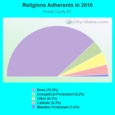
| Religion | Adherents | Congregations |
|---|---|---|
| Evangelical Protestant | 574 | 7 |
| Other | 570 | 3 |
| Catholic | 435 | 3 |
| Mainline Protestant | 112 | 2 |
| None | 5,336 | - |
Food Environment Statistics:
| Powell County: | 2.81 / 10,000 pop. |
| State: | 2.55 / 10,000 pop. |
| Powell County: | 1.41 / 10,000 pop. |
| Montana: | 4.69 / 10,000 pop. |
| This county: | 14.05 / 10,000 pop. |
| Montana: | 10.38 / 10,000 pop. |
| Powell County: | 7.3% |
| State: | 7.2% |
| This county: | 25.4% |
| Montana: | 23.1% |
| Here: | 15.4% |
| Montana: | 10.7% |
Strongest AM radio stations in Helmville:
- KERR (750 AM; 50 kW; POLSON, MT; Owner: ANDERSON RADIO BROADCASTING, INC.)
- KOFI (1180 AM; 50 kW; KALISPELL, MT; Owner: KOFI, INC.)
- KLCY (930 AM; 5 kW; EAST MISSOULA, MT; Owner: CAPSTAR TX LIMITED PARTNERSHIP)
- KKGR (680 AM; daytime; 5 kW; EAST HELENA, MT; Owner: KKGR, INC.)
- KMTX (950 AM; 5 kW; HELENA, MT; Owner: CAPRI, INC)
- KGVO (1290 AM; 5 kW; MISSOULA, MT; Owner: CAPSTAR TX LIMITED PARTNERSHIP)
- KBOW (550 AM; 5 kW; BUTTE, MT; Owner: BUTTE BROADCASTING INCORPORATED)
- KMON (560 AM; 5 kW; GREAT FALLS, MT; Owner: COMMONWEALTH LICENSE SUBSIDIARY, LLC)
- KGVW (640 AM; 10 kW; BELGRADE, MT; Owner: GALLATIN VALLEY WITNESS, INC.)
- KBOI (670 AM; 50 kW; BOISE, ID; Owner: CITADEL BROADCASTING COMPANY)
- KJJR (880 AM; 10 kW; WHITEFISH, MT; Owner: BEE BROADCASTING, INCORPORATED)
- KGA (1510 AM; 50 kW; SPOKANE, WA; Owner: CITADEL BROADCASTING COMPANY)
- KXTL (1370 AM; 5 kW; BUTTE, MT; Owner: FISHER RADIO REGIONAL GROUP, INC.)
Strongest FM radio stations in Helmville:
- KGGL (93.3 FM; MISSOULA, MT; Owner: FISHER RADIO REGIONAL GROUP, INC.)
- KYSS-FM (94.9 FM; MISSOULA, MT; Owner: CAPSTAR TX LIMITED PARTNERSHIP)
- KUFM (89.1 FM; MISSOULA, MT; Owner: UNIVERSITY OF MONTANA)
- KMTX-FM (105.3 FM; HELENA, MT; Owner: CAPRI, INC)
- KZMT (101.1 FM; HELENA, MT; Owner: COMMONWEALTH LICENSE SUBSIDIARY, LLC)
- KBQQ (106.7 FM; PINESDALE, MT; Owner: FISHER RADIO REGIONAL GROUP INC.)
- KZOQ-FM (100.1 FM; MISSOULA, MT; Owner: FISHER RADIO REGIONAL GROUP, INC.)
- KMZL (91.1 FM; MISSOULA, MT; Owner: FAITH COMMUNICATIONS CORP.)
- K204EV (88.7 FM; MISSOULA, MT; Owner: CALVARY CHAPEL OF TWIN FALLS, INC.)
- KMSO (102.5 FM; MISSOULA, MT; Owner: SHEILA CALLAHAN & FRIENDS, INC)
- KPLG (91.5 FM; PLAINS, MT; Owner: YOUR NETWORK OF PRAISE, INC.)
- KVCM (103.1 FM; HELENA, MT; Owner: HI-LINE RADIO FELLOWSHIP, INC.)
- K210BF (89.9 FM; BUTTE, MT; Owner: FAMILY STATIONS, INC.)
- K246AC (97.1 FM; HELENA, MT; Owner: LAST CHANCE PUBLIC RADIO ASSOCIATION)
- K251AC (98.1 FM; HELENA, MT; Owner: BOARD OF REGENTS-MT UNIV. SYSTEM)
- K213CB (90.5 FM; DEER LODGE, MT; Owner: HI-LINE RADIO FELLOWSHIP, INC.)
TV broadcast stations around Helmville:
- K05EE (Channel 5; BIG ARM, ETC., MT; Owner: BLACKTAIL TV TAX DISTRICT)
FCC Registered Antenna Towers:
4- Robert Leedham, 4.9 Mi At 89 Degrees From (Lat: 46.864444 Lon: -112.861667), Type: 67.1, Overall height: 67.1 m, Registrant: The Burlington Northern And Santa Fe Railway Co, Jerry.Elmore@bnsf.Com, , Kansa-s City, Phone: (913) 551-4568
- Robert Leedham, 4.9 Mi At 89 Degrees From (Lat: 46.864444 Lon: -112.861667), Type: 67.1, Overall height: 67.1 m, Registrant: The Burlington Northern And Santa Fe Railway Co, Jerry.Elmore@bnsf.Com, , Kansa-s City, Phone: (913) 551-4568
- David Clark, 4.9 Mi At 89 Degrees From (Lat: 46.864444 Lon: -112.861667), Type: 67.1, Structure height: 30077 m, Overall height: 67.1 m, Registrant: The Burlington Northern And Santa Fe Railway Co, Kansa-s City, Phone: (913) 551-4700
- 4.9 Mi At 89 Degrees From (Lat: 46.864444 Lon: -112.861667), Type: 67.1, Overall height: 67.1 m, Registrant: Burlington Northern And Santa Fe Railway Company, Toddh@writeme.Com, , Kansa-s City, Phone: (913) 551-4627
FCC Registered Broadcast Land Mobile Towers:
1- 1000 Garnet Mountain Lane (Lat: 46.887528 Lon: -113.053083), Type: Bant, Structure height: 7.6 m, Overall height: 9.1 m, Call Sign: KNGE249,
Assigned Frequencies: 151.550 MHz, Grant Date: 06/06/2013, Expiration Date: 02/11/2023, Cancellation Date: 04/15/2023, Registrant: Federal Licensing, Inc., 1588 Fairfield Road, Gettysburg, PA 17325, Phone: (717) 334-9262, Fax: (717) 334-6440
FCC Registered Microwave Towers:
1- STATION, 4.9 Mi At 89 Degrees From (Lat: 46.864361 Lon: -112.861694), Overall height: 67.1 m, Call Sign: WAA803,
Assigned Frequencies: 6745.00 MHz, 6845.00 MHz, Grant Date: 04/20/1999, Expiration Date: 06/30/2009, Cancellation Date: 04/15/2009, Registrant: Bnsf Railway Co., 4515 Kansas Ave, Kansas City, KS 66106, Phone: (914) 551-4615, Fax: (913) 551-4053, Email:
FAA Registered Aircraft:
1- Aircraft: CESSNA T182T (Category: Land, Seats: 4, Weight: Up to 12,499 Pounds), Engine: LYCOMING TI0-540 SER (310 HP) (Reciprocating)
N-Number: 1982K, N1982K, N-1982K, Serial Number: T18208442, Year manufactured: 2005, Airworthiness Date: 09/15/2005, Certificate Issue Date: 04/06/2017
Registrant (Individual): Kevin A Bloxham, 4105 Wales Creek Rd, Helmville, MT 59843
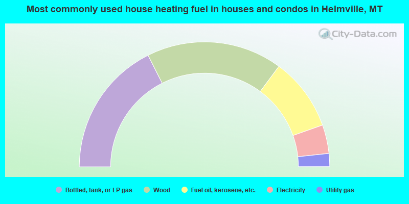
- 35.1%Bottled, tank, or LP gas
- 35.1%Wood
- 18.9%Fuel oil, kerosene, etc.
- 7.4%Electricity
- 3.4%Utility gas
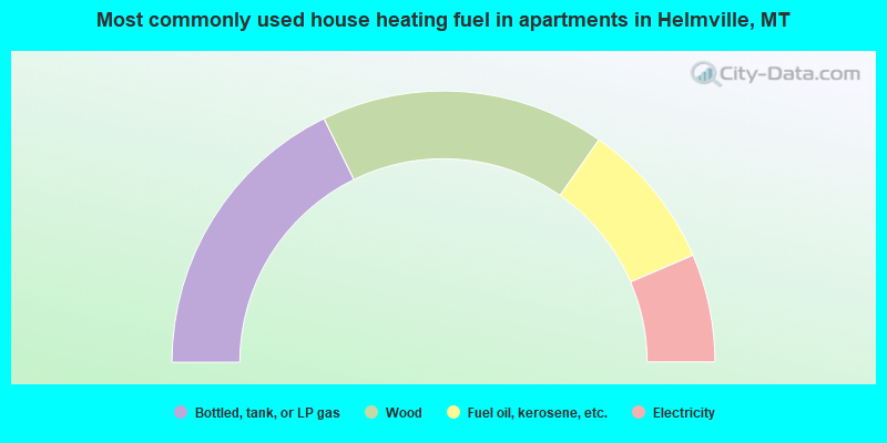
- 35.5%Bottled, tank, or LP gas
- 33.9%Wood
- 17.7%Fuel oil, kerosene, etc.
- 12.9%Electricity
Helmville compared to Montana state average:
- Unemployed percentage below state average.
- Hispanic race population percentage significantly below state average.
- Median age above state average.
- Foreign-born population percentage significantly below state average.
- Length of stay since moving in significantly above state average.
- Number of rooms per house significantly below state average.
- House age significantly below state average.
- Number of college students significantly below state average.