Hinsdale, Massachusetts
Submit your own pictures of this town and show them to the world
- OSM Map
- General Map
- Google Map
- MSN Map
Population change since 2000: +8.5%
 |
| Males: 1,018 | |
| Females: 1,014 |
| Median resident age: | 46.5 years |
| Massachusetts median age: | 39.2 years |
Zip codes: 01235.
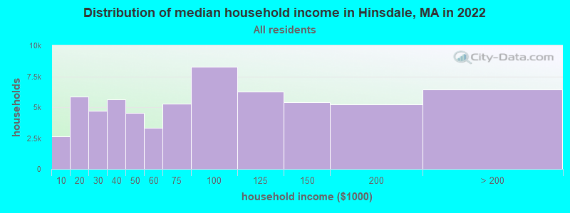
| Hinsdale: | $80,736 |
| MA: | $94,488 |
Estimated per capita income in 2022: $44,405 (it was $19,797 in 2000)
Hinsdale town income, earnings, and wages data
Estimated median house or condo value in 2022: $313,683 (it was $117,300 in 2000)
| Hinsdale: | $313,683 |
| MA: | $534,700 |
Mean prices in 2022: all housing units: $357,971; detached houses: $376,086; townhouses or other attached units: $341,816; in 2-unit structures: $250,940; in 3-to-4-unit structures: $400,871; in 5-or-more-unit structures: $281,990; mobile homes: $80,872
Detailed information about poverty and poor residents in Hinsdale, MA


- 1,97697.2%White alone
- 221.1%Two or more races
- 180.9%Hispanic
- 80.4%Black alone
- 70.3%Asian alone
- 10.05%American Indian alone
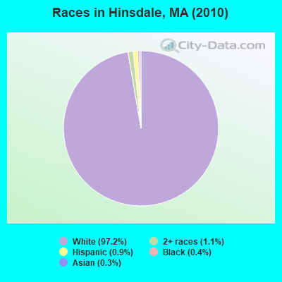
Races in Hinsdale detailed stats: ancestries, foreign born residents, place of birth
According to our research of Massachusetts and other state lists, there were 4 registered sex offenders living in Hinsdale, Massachusetts as of May 19, 2024.
The ratio of all residents to sex offenders in Hinsdale is 508 to 1.
Type |
2009 |
2010 |
2011 |
2020 |
2021 |
|---|---|---|---|---|---|
| Murders (per 100,000) | 0 (0.0) | 0 (0.0) | 0 (0.0) | 0 (0.0) | 0 (0.0) |
| Rapes (per 100,000) | 0 (0.0) | 0 (0.0) | 1 (48.9) | 0 (0.0) | 0 (0.0) |
| Robberies (per 100,000) | 0 (0.0) | 0 (0.0) | 0 (0.0) | 0 (0.0) | 0 (0.0) |
| Assaults (per 100,000) | 6 (305.2) | 5 (246.1) | 5 (244.6) | 6 (316.0) | 6 (317.5) |
| Burglaries (per 100,000) | 1 (50.9) | 2 (98.4) | 17 (831.7) | 0 (0.0) | 0 (0.0) |
| Thefts (per 100,000) | 1 (50.9) | 0 (0.0) | 12 (587.1) | 0 (0.0) | 0 (0.0) |
| Auto thefts (per 100,000) | 1 (50.9) | 0 (0.0) | 0 (0.0) | 0 (0.0) | 0 (0.0) |
| Arson (per 100,000) | 0 (0.0) | 0 (0.0) | 1 (48.9) | 0 (0.0) | 0 (0.0) |
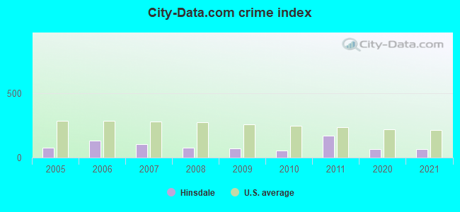
| City-Data.com crime index | 70.7 | 56.1 | 169.8 | 63.2 | 63.5 |
The City-Data.com crime index weighs serious crimes and violent crimes more heavily. Higher means more crime, U.S. average is 246.1. It adjusts for the number of visitors and daily workers commuting into cities.
Crime rate in Hinsdale detailed stats: murders, rapes, robberies, assaults, burglaries, thefts, arson
Full-time law enforcement employees in 2021, including police officers: 4 (4 officers - 2 male; 2 female).
| Officers per 1,000 residents here: | 2.12 |
| Massachusetts average: | 2.53 |
 Recent articles from our blog. Our writers, many of them Ph.D. graduates or candidates, create easy-to-read articles on a wide variety of topics.

 | MA 2022 Question 1 (258 replies) |
| Moving to MA (40 replies) |
| If you could choose any suburb, which one... (186 replies) |
| Moving to work in Back Bay from Chicago in next couple of months (71 replies) |
| How Much Massachusetts Households Make Per Year: Census Data (37 replies) |
| Old Farm but New Needs (95 replies) |
Latest news from Hinsdale, MA collected exclusively by city-data.com from local newspapers, TV, and radio stations
Ancestries: Irish (23.3%), English (17.0%), German (15.9%), French (15.1%), Italian (13.1%), Polish (9.3%).
Current Local Time: EST time zone
Incorporated in 1804
Elevation: 1442 feet
Land area: 20.8 square miles.
Population density: 98 people per square mile (very low).
38 residents are foreign born (1.2% Europe, 0.5% Latin America, 0.2% North America).
| This town: | 2.0% |
| Massachusetts: | 12.2% |
| Hinsdale town: | 1.4% ($1,584) |
| Massachusetts: | 1.3% ($2,336) |
Nearest city with pop. 50,000+: Chicopee, MA  (32.5 miles , pop. 54,653).
Nearest city with pop. 200,000+: Boston, MA (103.7 miles , pop. 589,141).
Nearest city with pop. 1,000,000+: Bronx, NY (116.7 miles , pop. 1,332,650).
Nearest cities:
), ), ), ), ), ), )Latitude: 42.44 N, Longitude: 73.11 W
Area code: 413
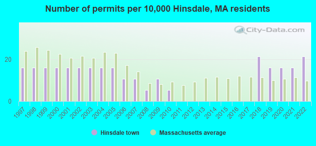
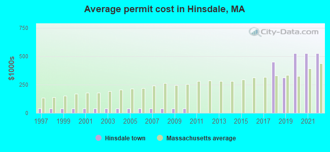
Single-family new house construction building permits:
- 2022: 4 buildings, average cost: $526,700
- 2021: 3 buildings, average cost: $526,700
- 2020: 3 buildings, average cost: $526,700
- 2019: 3 buildings, average cost: $313,300
- 2018: 4 buildings, average cost: $450,000
- 2010: 1 building, cost: $39,100
- 2009: 2 buildings, average cost: $39,100
- 2008: 1 building, cost: $39,100
- 2007: 2 buildings, average cost: $39,100
- 2006: 2 buildings, average cost: $39,100
- 2005: 3 buildings, average cost: $39,100
- 2004: 3 buildings, average cost: $39,100
- 2003: 3 buildings, average cost: $39,100
- 2002: 3 buildings, average cost: $39,100
- 2001: 3 buildings, average cost: $39,100
- 2000: 3 buildings, average cost: $39,100
- 1999: 3 buildings, average cost: $39,100
- 1998: 3 buildings, average cost: $39,100
- 1997: 3 buildings, average cost: $39,100
| Here: | 5.3% |
| Massachusetts: | 3.5% |
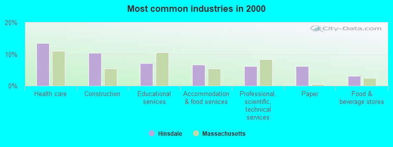
- Health care (13.5%)
- Construction (10.4%)
- Educational services (7.1%)
- Accommodation & food services (6.7%)
- Professional, scientific, technical services (6.2%)
- Paper (6.2%)
- Food & beverage stores (3.0%)
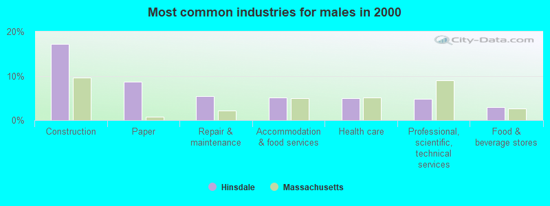
- Construction (17.3%)
- Paper (8.7%)
- Repair & maintenance (5.4%)
- Accommodation & food services (5.2%)
- Health care (5.0%)
- Professional, scientific, technical services (4.8%)
- Food & beverage stores (3.0%)
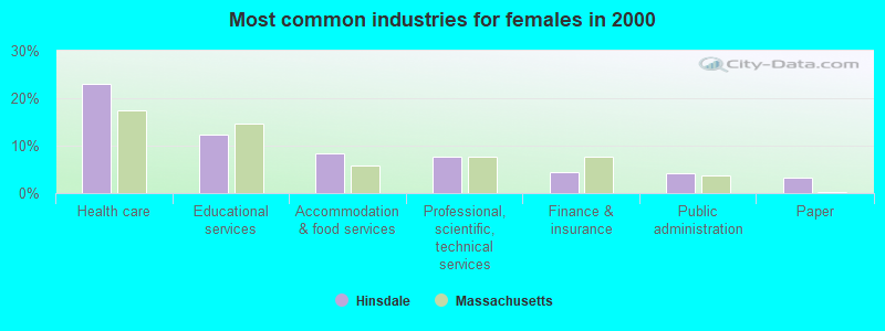
- Health care (23.1%)
- Educational services (12.4%)
- Accommodation & food services (8.4%)
- Professional, scientific, technical services (7.8%)
- Finance & insurance (4.4%)
- Public administration (4.2%)
- Paper (3.3%)
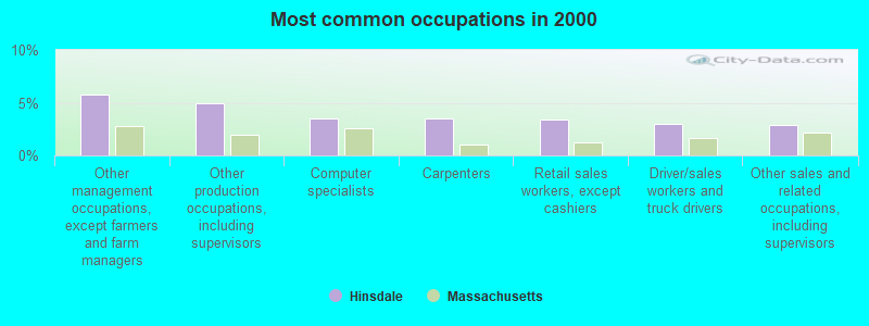
- Other management occupations, except farmers and farm managers (5.8%)
- Other production occupations, including supervisors (4.9%)
- Computer specialists (3.5%)
- Carpenters (3.5%)
- Retail sales workers, except cashiers (3.4%)
- Driver/sales workers and truck drivers (3.0%)
- Other sales and related occupations, including supervisors (2.9%)
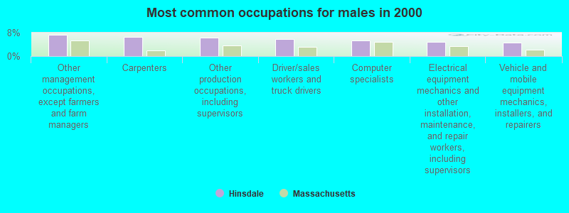
- Other management occupations, except farmers and farm managers (7.3%)
- Carpenters (6.5%)
- Other production occupations, including supervisors (6.3%)
- Driver/sales workers and truck drivers (5.8%)
- Computer specialists (5.4%)
- Electrical equipment mechanics and other installation, maintenance, and repair workers, including supervisors (4.8%)
- Vehicle and mobile equipment mechanics, installers, and repairers (4.6%)
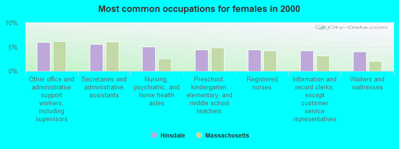
- Other office and administrative support workers, including supervisors (6.0%)
- Secretaries and administrative assistants (5.5%)
- Nursing, psychiatric, and home health aides (5.1%)
- Preschool, kindergarten, elementary, and middle school teachers (4.4%)
- Registered nurses (4.4%)
- Information and record clerks, except customer service representatives (4.2%)
- Waiters and waitresses (4.0%)
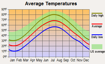
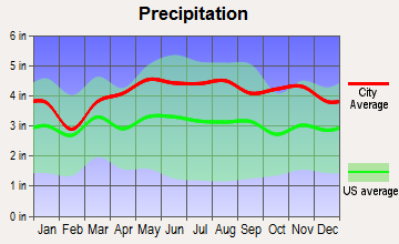
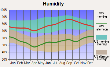
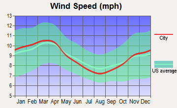
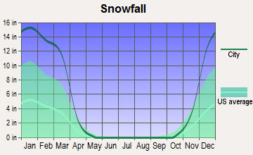
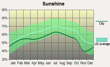
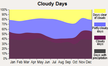
Average climate in Hinsdale, Massachusetts
Based on data reported by over 4,000 weather stations
(lower is better)
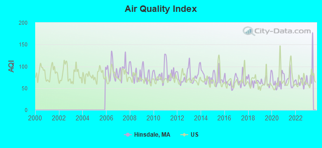
Air Quality Index (AQI) level in 2022 was 63.5. This is about average.
| City: | 63.5 |
| U.S.: | 72.6 |
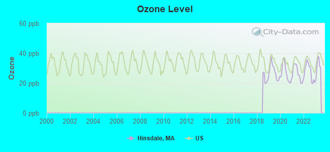
Ozone [ppb] level in 2022 was 27.5. This is better than average. Closest monitor was 4.6 miles away from the city center.
| City: | 27.5 |
| U.S.: | 33.3 |
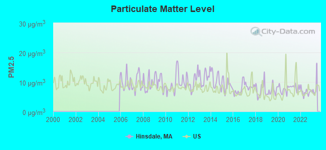
Particulate Matter (PM2.5) [µg/m3] level in 2022 was 6.62. This is better than average. Closest monitor was 6.6 miles away from the city center.
| City: | 6.62 |
| U.S.: | 8.11 |
Tornado activity:
Hinsdale-area historical tornado activity is slightly above Massachusetts state average. It is 17% smaller than the overall U.S. average.
On 8/28/1973, a category F4 (max. wind speeds 207-260 mph) tornado 15.7 miles away from the Hinsdale town center killed 4 people and injured 36 people and caused between $5,000,000 and $50,000,000 in damages.
On 5/29/1995, a category F4 tornado 18.6 miles away from the town center killed 3 people and injured 24 people and caused between $5,000,000 and $50,000,000 in damages.
Earthquake activity:
Hinsdale-area historical earthquake activity is significantly above Massachusetts state average. It is 69% smaller than the overall U.S. average.On 10/7/1983 at 10:18:46, a magnitude 5.3 (5.1 MB, 5.3 LG, 5.1 ML, Class: Moderate, Intensity: VI - VII) earthquake occurred 121.9 miles away from the city center
On 4/20/2002 at 10:50:47, a magnitude 5.3 (5.3 ML, Depth: 3.0 mi) earthquake occurred 146.6 miles away from Hinsdale center
On 4/20/2002 at 10:50:47, a magnitude 5.2 (5.2 MB, 4.2 MS, 5.2 MW, 5.0 MW) earthquake occurred 145.1 miles away from the city center
On 1/19/1982 at 00:14:42, a magnitude 4.7 (4.5 MB, 4.7 MD, 4.5 LG, Class: Light, Intensity: IV - V) earthquake occurred 106.2 miles away from Hinsdale center
On 10/16/2012 at 23:12:25, a magnitude 4.7 (4.7 ML, Depth: 10.0 mi) earthquake occurred 148.0 miles away from the city center
On 6/17/1991 at 08:53:16, a magnitude 4.1 (4.0 MB, 4.0 LG, Depth: 3.1 mi) earthquake occurred 80.9 miles away from the city center
Magnitude types: regional Lg-wave magnitude (LG), body-wave magnitude (MB), duration magnitude (MD), local magnitude (ML), surface-wave magnitude (MS), moment magnitude (MW)
Natural disasters:
The number of natural disasters in Berkshire County (21) is greater than the US average (15).Major Disasters (Presidential) Declared: 10
Emergencies Declared: 10
Causes of natural disasters: Floods: 5, Snowstorms: 5, Storms: 5, Hurricanes: 4, Winter Storms: 4, Blizzards: 2, Snows: 2, Snowfall: 1, Tropical Storm: 1, Wind: 1, Other: 1 (Note: some incidents may be assigned to more than one category).
Hospitals and medical centers in Hinsdale:
Other hospitals and medical centers near Hinsdale:
- CRANEVILLE PLACE AT DALTON (Nursing Home, about 5 miles away; DALTON, MA)
- MT GREYLOCK EXTENDED CARE FACILITY (Nursing Home, about 8 miles away; PITTSFIELD, MA)
- BERKSHIRE MEDICAL CENTER INC Acute Care Hospitals (about 8 miles away; PITTSFIELD, MA)
- BERKSHIRE PLACE (Nursing Home, about 8 miles away; PITTSFIELD, MA)
- HOSPICE OF THE BERKSHIRES, INC (Hospital, about 8 miles away; PITTSFIELD, MA)
- VALLEY VIEW NURSING HOME (Nursing Home, about 9 miles away; LENOX, MA)
- CENTER FOR OPTIMUM CARE-BERKSHIRE (Nursing Home, about 9 miles away; PITTSFIELD, MA)
Colleges/universities with over 2000 students nearest to Hinsdale:
- Williams College (about 20 miles; Williamstown, MA; Full-time enrollment: 2,141)
- Smith College (about 26 miles; Northampton, MA; FT enrollment: 3,549)
- Westfield State University (about 27 miles; Westfield, MA; FT enrollment: 5,548)
- Holyoke Community College (about 29 miles; Holyoke, MA; FT enrollment: 4,911)
- University of Massachusetts-Amherst (about 31 miles; Amherst, MA; FT enrollment: 26,583)
- Mount Holyoke College (about 31 miles; South Hadley, MA; FT enrollment: 2,573)
- Hudson Valley Community College (about 35 miles; Troy, NY; FT enrollment: 9,346)
Public elementary/middle school in Hinsdale:
- KITTREDGE (Students: 216, Location: 80 MAPLE STREET, Grades: PK-5)
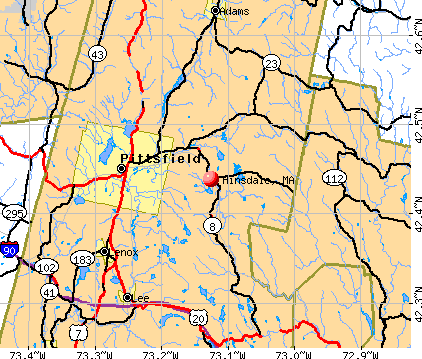
Points of interest:
Notable locations in Hinsdale: Bas-Ridge Country Club (A), Hinsdale Fire Department (B), Hinsdale Public Library (C), Hinsdale Town Hall (D). Display/hide their locations on the map
Cemetery: Saint Patricks Cemetery (1). Display/hide its location on the map
Reservoirs: Upper Sackett Reservoir (A), Ashmere Lake (B), Cleveland Brook Reservoir (C), Belmont Reservoir (D), Fernwood Reservoir (E), Lower Sackett Reservoir (F), Plunkett Reservoir (G). Display/hide their locations on the map
Streams, rivers, and creeks: Windsor Brook (A), Tracy Brook (B), Russo Brook (C), Kilburn Brook (D), Frisell Brook (E), Bilodeau Brook (F), Bennett Brook (G), Welsh Brook (H). Display/hide their locations on the map
Park in Hinsdale: Stritch Sculpture Garden (1). Display/hide its location on the map
Birthplace of: Francis E. Warren - Army Medal of Honor recipient, Anne Froelick - Politician, Ashley B. Wright - Politician.
Drinking water stations with addresses in Hinsdale and their reported violations in the past:
HINSDALE WATER DEPT (Population served: 1,800, Surface water):Past monitoring violations:SPORTS HAVEN MOBILE HOME PARK (Population served: 107, Groundwater):
- Monitoring of Treatment (SWTR-Filter) - In FEB-2012. Follow-up actions: St AO (w/o penalty) issued (APR-13-2012)
- 13 regular monitoring violations
Past health violations:BISSELVILLE ESTATE (Population served: 74, Groundwater):Past monitoring violations:
- MCL, Monthly (TCR) - In MAY-2014, Contaminant: Coliform. Follow-up actions: St AO (w/o penalty) issued (JUL-03-2014)
- MCL, Monthly (TCR) - In DEC-2013, Contaminant: Coliform. Follow-up actions: St AO (w/o penalty) issued (2 times from MAR-11-2014 to JUL-03-2014)
- MCL, Monthly (TCR) - In NOV-2013, Contaminant: Coliform. Follow-up actions: St AO (w/o penalty) issued (3 times from DEC-13-2013 to JUL-03-2014)
- MCL, Monthly (TCR) - In JUN-2010, Contaminant: Coliform. Follow-up actions: St AO (w/o penalty) issued (JUL-23-2010)
- Follow-up Or Routine LCR Tap M/R - In JUN-01-2012, Contaminant: Lead and Copper Rule. Follow-up actions: St AO (w/o penalty) issued (NOV-19-2012)
- Follow-up Or Routine LCR Tap M/R - In OCT-01-2006, Contaminant: Lead and Copper Rule. Follow-up actions: St Compliance achieved (SEP-29-2006), St AO (w/o penalty) issued (OCT-10-2006)
- 5 routine major monitoring violations
- 25 regular monitoring violations
Past health violations:ASHMERE WATER SERVICE (Population served: 66, Groundwater):Past monitoring violations:
- MCL, Monthly (TCR) - In JUL-2013, Contaminant: Coliform. Follow-up actions: St AO (w/o penalty) issued (MAY-21-2014)
- MCL, Monthly (TCR) - In MAY-2013, Contaminant: Coliform. Follow-up actions: St AO (w/o penalty) issued (2 times from JUN-26-2013 to MAY-21-2014)
- MCL, Monthly (TCR) - In APR-2013, Contaminant: Coliform. Follow-up actions: St AO (w/o penalty) issued (2 times from MAY-17-2013 to MAY-21-2014)
- MCL, Monthly (TCR) - In MAR-2013, Contaminant: Coliform. Follow-up actions: St AO (w/o penalty) issued (2 times from APR-26-2013 to MAY-21-2014)
- MCL, Monthly (TCR) - In OCT-2012, Contaminant: Coliform. Follow-up actions: St AO (w/o penalty) issued (2 times from OCT-26-2012 to MAY-21-2014)
- Monitoring, Repeat Major (TCR) - In MAY-2013, Contaminant: Coliform (TCR). Follow-up actions: St AO (w/o penalty) issued (2 times from JUN-26-2013 to MAY-21-2014)
- Monitoring, Source Water (GWR) - In MAY-01-2013, Contaminant: E. COLI. Follow-up actions: St AO (w/o penalty) issued (3 times from MAY-17-2013 to MAY-21-2014)
- Monitoring, Repeat Major (TCR) - In APR-2013, Contaminant: Coliform (TCR). Follow-up actions: St AO (w/o penalty) issued (2 times from APR-26-2013 to MAY-21-2014)
- Follow-up Or Routine LCR Tap M/R - In JUN-01-2012, Contaminant: Lead and Copper Rule. Follow-up actions: St AO (w/o penalty) issued (NOV-19-2012)
- Follow-up Or Routine LCR Tap M/R - In JUN-01-2011, Contaminant: Lead and Copper Rule. Follow-up actions: St Admin Penalty assessed (OCT-27-2011), St AO (w/o penalty) issued (OCT-22-2012)
- 15 routine major monitoring violations
- 5 minor monitoring violations
- 78 regular monitoring violations
- One other older monitoring violation
Past health violations:Past monitoring violations:
- MCL, Monthly (TCR) - In JUN-2014, Contaminant: Coliform. Follow-up actions: St AO (w/o penalty) issued (AUG-11-2014)
- Follow-up Or Routine LCR Tap M/R - In JAN-01-2011, Contaminant: Lead and Copper Rule. Follow-up actions: St AO (w/o penalty) issued (FEB-12-2014)
- Follow-up Or Routine LCR Tap M/R - In OCT-01-2006, Contaminant: Lead and Copper Rule. Follow-up actions: St AO (w/o penalty) issued (DEC-06-2006), St Compliance achieved (FEB-03-2010)
- 4 regular monitoring violations
| This town: | 2.3 people |
| Massachusetts: | 2.5 people |
| This town: | 67.3% |
| Whole state: | 63.0% |
| This town: | 8.8% |
| Whole state: | 7.0% |
Likely homosexual households (counted as self-reported same-sex unmarried-partner households)
- Lesbian couples: 0.7% of all households
- Gay men: 0.2% of all households
| This town: | 8.2% |
| Whole state: | 9.3% |
| This town: | 2.6% |
| Whole state: | 4.4% |
For population 15 years and over in Hinsdale:
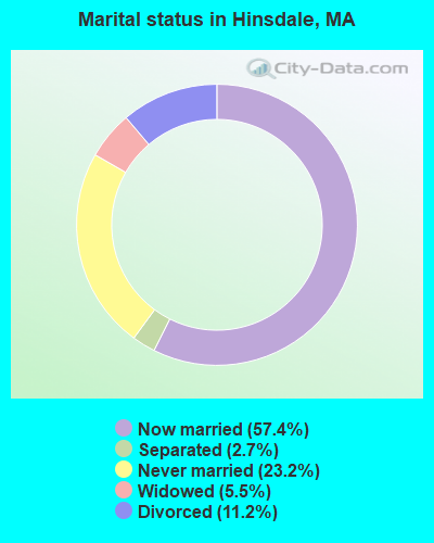
- Never married: 23.2%
- Now married: 57.4%
- Separated: 2.7%
- Widowed: 5.5%
- Divorced: 11.2%
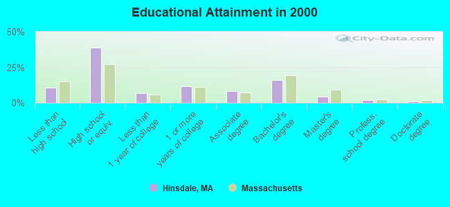
For population 25 years and over in Hinsdale:
- High school or higher: 89.1%
- Bachelor's degree or higher: 23.5%
- Graduate or professional degree: 7.4%
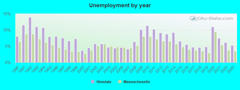
- Unemployed: 4.1%
- Mean travel time to work (commute): 22.7 minutes
| Here: | 9.7 |
| Massachusetts average: | 13.1 |


Graphs represent county-level data. Detailed 2008 Election Results
Religion statistics for Hinsdale, MA (based on Berkshire County data)


| Religion | Adherents | Congregations |
|---|---|---|
| Catholic | 50,187 | 32 |
| Mainline Protestant | 9,895 | 63 |
| Other | 3,647 | 20 |
| Evangelical Protestant | 2,817 | 28 |
| Black Protestant | 233 | 2 |
| Orthodox | 225 | 2 |
| None | 64,215 | - |
Food Environment Statistics:
| This county: | 2.54 / 10,000 pop. |
| Massachusetts: | 1.98 / 10,000 pop. |
| Berkshire County: | 1.61 / 10,000 pop. |
| State: | 2.22 / 10,000 pop. |
| Berkshire County: | 4.08 / 10,000 pop. |
| State: | 1.77 / 10,000 pop. |
| Berkshire County: | 15.00 / 10,000 pop. |
| Massachusetts: | 8.76 / 10,000 pop. |
| Here: | 8.0% |
| Massachusetts: | 8.1% |
| Here: | 22.8% |
| State: | 22.5% |
| This county: | 9.9% |
| State: | 16.5% |
Strongest AM radio stations in Hinsdale:
- WNNZ (640 AM; 50 kW; WESTFIELD, MA; Owner: CLEAR CHANNEL BROADCASTING LICENSES, INC.)
- WUHN (1110 AM; daytime; 5 kW; PITTSFIELD, MA; Owner: WEINER BROADCASTING, INC.)
- WBRK (1340 AM; 1 kW; PITTSFIELD, MA; Owner: WBRK, INC.)
- WGY (810 AM; 50 kW; SCHENECTADY, NY; Owner: CLEAR CHANNEL BROADCASTING LICENSES, INC.)
- WTIC (1080 AM; 50 kW; HARTFORD, CT; Owner: INFINITY RADIO OPERATIONS INC.)
- WPTR (1540 AM; 50 kW; ALBANY, NY; Owner: KIMTRON, INC.)
- WCRN (830 AM; 50 kW; WORCESTER, MA; Owner: CARTER BROADCASTING CORPORATION)
- WHYN (560 AM; 5 kW; SPRINGFIELD, MA; Owner: CLEAR CHANNEL BROADCASTING LICENSES, INC.)
- WVNE (760 AM; daytime; 25 kW; LEICESTER, MA; Owner: BLOUNT MASSCOM, INC.)
- WBEC (1420 AM; 1 kW; PITTSFIELD, MA; Owner: GREAT NORTHERN RADIO, LLC)
- WIZZ (1520 AM; daytime; 10 kW; GREENFIELD, MA; Owner: P. & M. RADIO, LLC)
- WSBS (860 AM; 3 kW; GREAT BARRINGTON, MA; Owner: BERKSHIRE BROADCASTING CO., INC.)
- WRKO (680 AM; 50 kW; BOSTON, MA; Owner: ENTERCOM BOSTON LICENSE, LLC)
Strongest FM radio stations in Hinsdale:
- WAMC-FM (90.3 FM; ALBANY, NY; Owner: WAMC)
- WBEC-FM (105.5 FM; PITTSFIELD, MA; Owner: GREAT NORTHERN RADIO, LLC)
- WUPE (95.9 FM; PITTSFIELD, MA; Owner: WEINER BROADCASTING, INC.)
- WHVP (91.1 FM; HUDSON, NY; Owner: SOUND OF LIFE, INC.)
- WZEC (97.5 FM; HOOSICK FALLS, NY; Owner: GREAT NORTHERN RADIO, LLC)
- WEQX (102.7 FM; MANCHESTER, VT; Owner: NORTHSHIRE COMMUNICATIONS, INC.)
- WJAN (95.1 FM; SUNDERLAND, VT; Owner: 6 JOHNSON ROAD LICENSES, INC.)
- WHYN-FM (93.1 FM; SPRINGFIELD, MA; Owner: CLEAR CHANNEL BROADCASTING LICENSES, INC.)
- WVAY (100.7 FM; WILMINGTON, VT; Owner: GREAT NORTHERN RADIO, L.L.C.)
- WAMQ (105.1 FM; GREAT BARRINGTON, MA; Owner: WAMC)
- WRNX (100.9 FM; AMHERST, MA; Owner: WESTERN MASSACHUSETTS RADIO COMPANY)
- WMNB (100.1 FM; NORTH ADAMS, MA; Owner: BERKSHIRE BROADCASTING CO., INC.)
- WBRK-FM (101.7 FM; PITTSFIELD, MA; Owner: WBRK, INC.)
- WFCR (88.5 FM; AMHERST, MA; Owner: UNIVERSITY OF MASSACHUSETTS)
- WPVQ (95.3 FM; GREENFIELD, MA; Owner: GREAT NORTHERN RADIO, L.L.C.)
- WAQY (102.1 FM; SPRINGFIELD, MA; Owner: SAGA COMMUNICATIONS OF NEW ENGLAND, LLC)
- WRSY (101.5 FM; MARLBORO, VT; Owner: GREAT NORTHERN RADIO, L.L.C.)
- WLZX (99.3 FM; NORTHAMPTON, MA; Owner: SAGA COMMUNICATIONS OF NEW ENGLAND, LLC)
- WAMH (89.3 FM; AMHERST, MA; Owner: TRUSTEES OF AMHERST COLLEGE)
- WHAI (98.3 FM; GREENFIELD, MA; Owner: SAGA COMMUNICATIONS OF NEW ENGLAND, LLC)
TV broadcast stations around Hinsdale:
- WTIC-TV (Channel 61; HARTFORD, CT; Owner: TRIBUNE TELEVISION COMPANY)
- W35BK (Channel 35; PLAINFIELD, MA; Owner: LYDIA SYLVANE STOCKWELL)
- WCDC-TV (Channel 19; ADAMS, MA; Owner: YOUNG BROADCASTING OF ALBANY, INC.)
- W38DL (Channel 38; ADAMS, ETC., MA; Owner: WNYT-TV, LLC)
- W07AI (Channel 7; PITTSFIELD, ETC., MA; Owner: WNYT-TV, LLC)
Medal of Honor Recipients
Medal of Honor Recipients born in Hinsdale: Francis E. Warren, James M. Burt.
- Hinsdale, Massachusetts
- Fatal accident count13
- Vehicles involved in fatal accidents14
- Fatal accidents involving drunk persons:4
- Fatalities14
- Persons involved in fatal accidents19
- Pedestrians involved in fatal accidents0
- Massachusetts average
- Fatal accident count4828
- Vehicles involved in fatal accidents6761
- Fatal accidents involving drunk persons1610
- Fatalities5179
- Persons involved in fatal accidents10986
- Pedestrians involved in fatal accidents520
- National Bridge Inventory (NBI) Statistics
- 12Number of bridges
- 59ft / 17.6mTotal length
- $11,535,000Total costs
- 20,493Total average daily traffic
- 1,784Total average daily truck traffic
- 14,561Total future (year 2031) average daily traffic
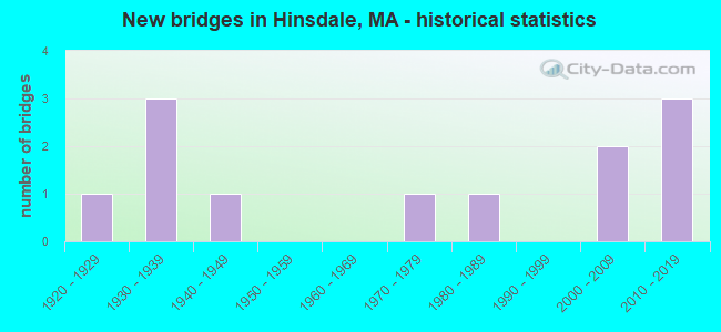
- New bridges - historical statistics
- 11920-1929
- 31930-1939
- 11940-1949
- 11970-1979
- 11980-1989
- 22000-2009
- 32010-2019
FCC Registered Antenna Towers:
14 (See the full list of FCC Registered Antenna Towers in Hinsdale)FCC Registered Broadcast Land Mobile Towers:
3- Fire Hdq Rte 143 & Maple St (Lat: 42.438972 Lon: -73.123167), Call Sign: KNDV352,
Assigned Frequencies: 154.310 MHz, Grant Date: 08/10/2022, Expiration Date: 09/25/2032, Registrant: 77 Curtis St, Hinsdale, MA 01235, Phone: (413) 822-9607, Email:
- 450 Michaels Road (Lat: 42.421833 Lon: -73.115944), Type: Tower, Structure height: 60.7 m, Call Sign: WPGN359,
Assigned Frequencies: 154.725 MHz, Grant Date: 12/17/2014, Expiration Date: 02/09/2025, Registrant: 520 Creamery Road, Hinsdale, MA 01235, Phone: (413) 655-8689, Fax: (413) 655-8267, Email:
- New Windsor Rd (Lat: 42.468417 Lon: -73.093167), Call Sign: WZQ750,
Assigned Frequencies: 48.0400 MHz, Grant Date: 10/17/2013, Expiration Date: 11/24/2023, Cancellation Date: 01/27/2024, Registrant: Keller And Heckman LLP, 1001 G Street Nw, Suite 500 West, Washington, DC 20001, Phone: (202) 434-4100, Fax: (202) 434-4646, Email:
FCC Registered Microwave Towers:
1- STATION, New Windsor Rd (Lat: 42.468694 Lon: -73.092306), Structure height: 3.7 m, Overall height: 6.7 m, Call Sign: WNTG237,
Assigned Frequencies: 956.262 MHz, Grant Date: 06/19/2020, Expiration Date: 07/24/2030, Registrant: Keller And Heckman LLP, 1001 G Street Nw, Suite 500 West, Washington, DC 20001, Phone: (202) 434-4100, Fax: (202) 434-4646, Email:
FCC Registered Amateur Radio Licenses:
11 (See the full list of FCC Registered Amateur Radio Licenses in Hinsdale)FAA Registered Aircraft:
1- Aircraft: CESSNA 172N (Category: Land, Seats: 4, Weight: Up to 12,499 Pounds, Speed: 105 mph), Engine: LYCOMING 0-320 SERIES (180 HP) (Reciprocating)
N-Number: 6468D, N6468D, N-6468D, Serial Number: 17272819, Year manufactured: 1979, Airworthiness Date: 06/01/1979, Certificate Issue Date: 06/12/2014
Registrant (Co-Owned): Laurence K Shorter, 92 Skyline Trl, Hinsdale, MA 01235, Other Owners: Karen D Shorter
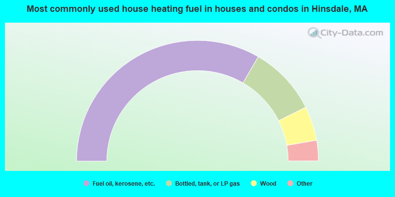
- 66.7%Fuel oil, kerosene, etc.
- 18.5%Bottled, tank, or LP gas
- 9.2%Wood
- 3.8%Electricity
- 1.0%Utility gas
- 0.3%Coal or coke
- 0.3%Other fuel
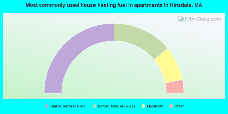
- 50.0%Fuel oil, kerosene, etc.
- 27.8%Bottled, tank, or LP gas
- 16.0%Electricity
- 3.7%Wood
- 1.2%Utility gas
- 1.2%Other fuel
Hinsdale compared to Massachusetts state average:
- Median house value below state average.
- Unemployed percentage significantly below state average.
- Black race population percentage significantly below state average.
- Hispanic race population percentage significantly below state average.
- Median age above state average.
- Foreign-born population percentage significantly below state average.
- Renting percentage below state average.
- Length of stay since moving in significantly above state average.
- Number of rooms per house significantly below state average.
- House age significantly below state average.

|
Total of 7 patent applications in 2008-2024.