Lanesborough, Massachusetts
Submit your own pictures of this town and show them to the world
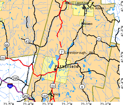
- OSM Map
- General Map
- Google Map
- MSN Map
Population change since 2000: +3.4%
 |
| Males: 1,521 | |
| Females: 1,570 |
| Median resident age: | 46.2 years |
| Massachusetts median age: | 39.2 years |
Zip codes: 01237.
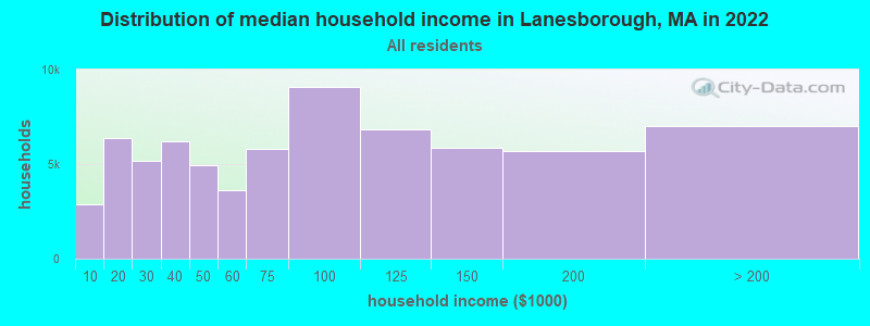
| Lanesborough: | $88,327 |
| MA: | $94,488 |
Estimated per capita income in 2022: $47,341 (it was $21,106 in 2000)
Lanesborough town income, earnings, and wages data
Estimated median house or condo value in 2022: $301,115 (it was $112,600 in 2000)
| Lanesborough: | $301,115 |
| MA: | $534,700 |
Mean prices in 2022: all housing units: $357,971; detached houses: $376,086; townhouses or other attached units: $341,816; in 2-unit structures: $250,940; in 3-to-4-unit structures: $400,871; in 5-or-more-unit structures: $281,990; mobile homes: $80,872
Detailed information about poverty and poor residents in Lanesborough, MA
Compare current foreclosures near Lanesborough, MA:
| Photo | Address | Area | Beds / Baths | Price | Details |
|---|---|---|---|---|---|

|
#1
Elmwood Ave
North Adams, MA 01247
|
2,777 sq. feet
|
3 baths 5 beds |
$215,000
|
show details |

|
#2
Crystal St
Lenox Dale, MA 01242
|
1,918 sq. feet
|
2 baths 3 beds |
$165,900
|
show details |

|
#3
Washington Mountain Rd
Lee, MA 01238
|
- sq. feet
|
1 baths 3 beds |
$155,000
|
show details |

|
#4
Grove St
Adams, MA 01220
|
2,644 sq. feet
|
2 baths 7 beds |
show details | |

|
#5
Franklin St
North Adams, MA 01247
|
1,386 sq. feet
|
1 baths 3 beds |
show details | |

|
#6
Arnold Ct
Cheshire, MA 01225
|
1,600 sq. feet
|
2 baths 2 beds |
show details | |

|
#7
Circular Ave
Pittsfield, MA 01201
|
2,808 sq. feet
|
4 baths 8 beds |
show details | |

|
#8
Robbins Ave
Pittsfield, MA 01201
|
1,872 sq. feet
|
2 baths 4 beds |
show details | |

|
#9
Daniels Ave
Pittsfield, MA 01201
|
3,040 sq. feet
|
3 baths 6 beds |
show details | |

|
#10
Barbour St
North Adams, MA 01247
|
1,224 sq. feet
|
1 baths 2 beds |
show details |
| Photo | Address | Area | Beds / Baths | Price | Details |
|---|---|---|---|---|---|

|
#11
Tierney Pl
Pittsfield, MA 01201
|
1,103 sq. feet
|
1 baths 3 beds |
show details | |

|
#12
Madison Ave
Pittsfield, MA 01201
|
2,192 sq. feet
|
2 baths 6 beds |
show details | |

|
#13
Weller Ave
Pittsfield, MA 01201
|
3,376 sq. feet
|
3 baths 6 beds |
show details | |

|
#14
North St
North Adams, MA 01247
|
1,164 sq. feet
|
1 baths 3 beds |
show details | |

|
#15
North St
Pittsfield, MA 01201
|
1,661 sq. feet
|
2 baths 4 beds |
show details | |

|
#16
Wilshire Dr
Cheshire, MA 01225
|
4,302 sq. feet
|
2 baths 3 beds |
show details | |

|
#17
Houghton St
North Adams, MA 01247
|
1,614 sq. feet
|
2 baths 4 beds |
show details | |

|
#18
Woodlawn Dr
Williamstown, MA 01267
|
1,806 sq. feet
|
2 baths 4 beds |
show details | |

|
#19
Old North Rd
Worthington, MA 01098
|
2,369 sq. feet
|
3 baths 4 beds |
show details | |

|
#20
Jennifer St
Lenox, MA 01240
|
1,416 sq. feet
|
1 baths 3 beds |
show details |
| Photo | Address | Area | Beds / Baths | Price | Details |
|---|---|---|---|---|---|

|
#21
Daniels Ct
Adams, MA 01220
|
1,400 sq. feet
|
1 baths 3 beds |
show details | |

|
#22
Valley St
Adams, MA 01220
|
1,680 sq. feet
|
2 baths 4 beds |
show details | |

|
#23
Frisbee St
East Chatham, NY 12060
|
2,400 sq. feet
|
2 baths 4 beds |
show details | |

|
#24
Richmond St
Adams, MA 01220
|
1,920 sq. feet
|
2 baths 4 beds |
show details | |

|
#25
Weber St # 12
Adams, MA 01220
|
1,728 sq. feet
|
2 baths 4 beds |
show details | |

|
#26
E Hoosac St
Adams, MA 01220
|
594 sq. feet
|
1 baths 2 beds |
show details | |

|
#27
Anthony St # B
Adams, MA 01220
|
1,622 sq. feet
|
2 baths 3 beds |
show details | |

|
#28
Rte 9
Windsor, MA 01270
|
1,223 sq. feet
|
1 baths 2 beds |
show details | |

|
#29
S Washington State Rd
Becket, MA 01223
|
1,620 sq. feet
|
1 baths 2 beds |
show details | |

|
#30
Morgan St
Lenox, MA 01240
|
3,959 sq. feet
|
2 baths 3 beds |
show details |
| Photo | Address | Area | Beds / Baths | Price | Details |
|---|---|---|---|---|---|

|
#31
Melville Ct
Lenox, MA 01240
|
3,988 sq. feet
|
6 baths 5 beds |
show details | |

|
#32
W Shaft Rd
North Adams, MA 01247
|
1,144 sq. feet
|
1 baths 3 beds |
show details | |

|
#33
David Dr
Hinsdale, MA 01235
|
1,664 sq. feet
|
2 baths 3 beds |
show details | |

|
#34
North St
Williamstown, MA 01267
|
1,552 sq. feet
|
2 baths 3 beds |
show details | |

|
#35
Church Rd
Drury, MA 01343
|
2,560 sq. feet
|
2 baths 4 beds |
show details | |

|
#36
Loop Rd
Savoy, MA 01256
|
1,040 sq. feet
|
1 baths 3 beds |
show details | |

|
#37
Houghton St
North Adams, MA 01247
|
3,380 sq. feet
|
3 baths 5 beds |
show details | |

|
#38
Linden St
Williamstown, MA 01267
|
2,298 sq. feet
|
3 baths 4 beds |
show details | |

|
#39
Upper Queechy Rd
Canaan, NY 12029
|
912 sq. feet
|
1 baths 2 beds |
show details | |

|
#40
East St
Lee, MA 01238
|
1,478 sq. feet
|
2 baths 3 beds |
show details |
| Photo | Address | Area | Beds / Baths | Price | Details |
|---|---|---|---|---|---|

|
#41
Franklin St
North Adams, MA 01247
|
1,386 sq. feet
|
1 baths 3 beds |
show details | |

|
#42
W Mountain Rd
Adams, MA 01220
|
1,173 sq. feet
|
1 baths 3 beds |
show details | |

|
#43
North St
North Adams, MA 01247
|
1,164 sq. feet
|
1 baths 3 beds |
show details | |

|
#44
Phelps Rd
North Adams, MA 01247
|
1,286 sq. feet
|
1 baths 4 beds |
show details | |

|
#45
Lenox Ave
Pittsfield, MA 01201
|
2,290 sq. feet
|
2 baths 6 beds |
show details | |

|
#46
Lenox Ave
Pittsfield, MA 01201
|
1,376 sq. feet
|
1 baths 3 beds |
show details | |

|
#47
Briggs Ave
Pittsfield, MA 01201
|
2,116 sq. feet
|
2 baths 4 beds |
show details | |

|
#48
Hancock Rd
Pittsfield, MA 01201
|
1,344 sq. feet
|
2 baths 3 beds |
show details | |

|
#49
Crystal St
Pittsfield, MA 01201
|
1,282 sq. feet
|
1 baths 3 beds |
show details | |

|
Check over 1 million property listings on Foreclosure.com!
|
browse all offers | |||

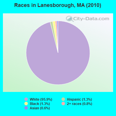
- 2,96395.9%White alone
- 391.3%Black alone
- 411.3%Hispanic
- 250.8%Two or more races
- 200.6%Asian alone
- 10.03%American Indian alone
- 10.03%Native Hawaiian and Other
Pacific Islander alone - 10.03%Other race alone
Races in Lanesborough detailed stats: ancestries, foreign born residents, place of birth
According to our research of Massachusetts and other state lists, there were 2 registered sex offenders living in Lanesborough, Massachusetts as of May 20, 2024.
The ratio of all residents to sex offenders in Lanesborough is 1,546 to 1.
The ratio of registered sex offenders to all residents in this city is near the state average.
 Recent articles from our blog. Our writers, many of them Ph.D. graduates or candidates, create easy-to-read articles on a wide variety of topics.


Latest news from Lanesborough, MA collected exclusively by city-data.com from local newspapers, TV, and radio stations
Ancestries: Irish (20.7%), Italian (20.3%), English (15.9%), German (12.7%), French (12.5%), Polish (8.8%).
Current Local Time: EST time zone
Incorporated in 1765
Elevation: 1130 feet
Land area: 29.0 square miles.
Population density: 106 people per square mile (very low).
69 residents are foreign born (1.3% Asia, 0.4% Europe, 0.2% Africa).
| This town: | 2.3% |
| Massachusetts: | 12.2% |
| Lanesborough town: | 1.3% ($1,487) |
| Massachusetts: | 1.3% ($2,336) |
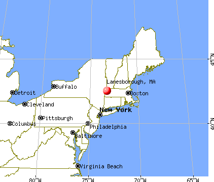
Nearest city with pop. 50,000+: Albany, NY  (29.3 miles , pop. 95,658).
Nearest city with pop. 200,000+: Boston, MA (110.6 miles , pop. 589,141).
Nearest city with pop. 1,000,000+: Bronx, NY (120.4 miles , pop. 1,332,650).
Nearest cities:
), ), ), ), ), Latitude: 42.52 N, Longitude: 73.24 W
Area code commonly used in this area: 413

Lanesborough tourist attractions:
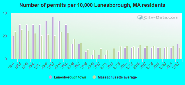
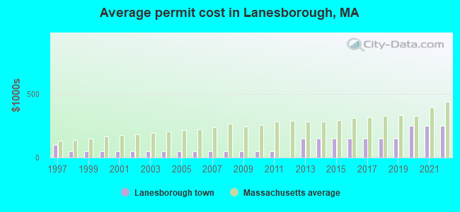
Single-family new house construction building permits:
- 2022: 4 buildings, average cost: $248,200
- 2021: 3 buildings, average cost: $248,200
- 2020: 3 buildings, average cost: $248,200
- 2019: 3 buildings, average cost: $151,100
- 2018: 3 buildings, average cost: $151,100
- 2017: 3 buildings, average cost: $151,100
- 2016: 3 buildings, average cost: $151,100
- 2015: 3 buildings, average cost: $151,100
- 2014: 3 buildings, average cost: $151,100
- 2013: 2 buildings, average cost: $151,100
- 2011: 1 building, cost: $52,300
- 2010: 1 building, cost: $52,300
- 2009: 1 building, cost: $52,300
- 2008: 2 buildings, average cost: $52,300
- 2007: 4 buildings, average cost: $52,300
- 2006: 4 buildings, average cost: $52,300
- 2005: 9 buildings, average cost: $52,300
- 2004: 10 buildings, average cost: $52,300
- 2003: 11 buildings, average cost: $52,300
- 2002: 10 buildings, average cost: $52,300
- 2001: 9 buildings, average cost: $52,300
- 2000: 9 buildings, average cost: $52,300
- 1999: 9 buildings, average cost: $52,300
- 1998: 9 buildings, average cost: $52,300
- 1997: 6 buildings, average cost: $99,900
| Here: | 3.5% |
| Massachusetts: | 3.5% |
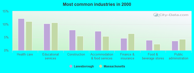
- Health care (12.2%)
- Educational services (10.2%)
- Construction (7.8%)
- Accommodation & food services (7.4%)
- Finance & insurance (4.7%)
- Food & beverage stores (3.9%)
- Public administration (3.6%)
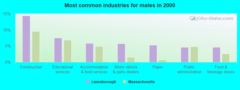
- Construction (14.4%)
- Educational services (7.5%)
- Accommodation & food services (5.9%)
- Motor vehicle & parts dealers (5.8%)
- Paper (5.3%)
- Public administration (4.7%)
- Food & beverage stores (4.7%)
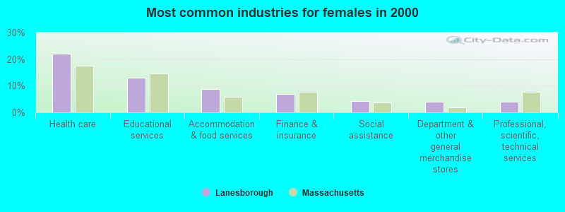
- Health care (22.1%)
- Educational services (12.9%)
- Accommodation & food services (8.9%)
- Finance & insurance (6.8%)
- Social assistance (4.3%)
- Department & other general merchandise stores (3.9%)
- Professional, scientific, technical services (3.9%)

- Other sales and related occupations, including supervisors (5.5%)
- Other production occupations, including supervisors (4.6%)
- Other management occupations, except farmers and farm managers (4.3%)
- Other office and administrative support workers, including supervisors (3.7%)
- Preschool, kindergarten, elementary, and middle school teachers (3.5%)
- Registered nurses (3.1%)
- Other teachers, instructors, education, training, and library occupations (3.1%)
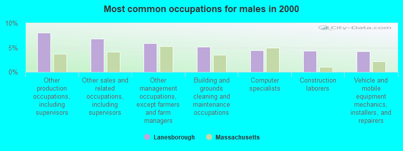
- Other production occupations, including supervisors (8.0%)
- Other sales and related occupations, including supervisors (6.8%)
- Other management occupations, except farmers and farm managers (5.9%)
- Building and grounds cleaning and maintenance occupations (5.2%)
- Computer specialists (4.4%)
- Construction laborers (4.3%)
- Vehicle and mobile equipment mechanics, installers, and repairers (4.2%)

- Other teachers, instructors, education, training, and library occupations (6.2%)
- Secretaries and administrative assistants (5.4%)
- Registered nurses (5.3%)
- Other office and administrative support workers, including supervisors (5.2%)
- Waiters and waitresses (4.9%)
- Other sales and related occupations, including supervisors (4.2%)
- Preschool, kindergarten, elementary, and middle school teachers (4.1%)
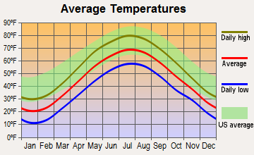
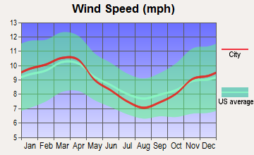
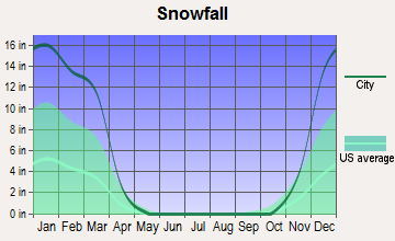
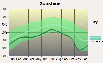
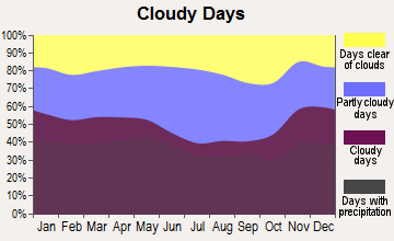
Average climate in Lanesborough, Massachusetts
Based on data reported by over 4,000 weather stations
(lower is better)
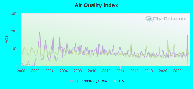
Air Quality Index (AQI) level in 2022 was 63.5. This is about average.
| City: | 63.5 |
| U.S.: | 72.6 |
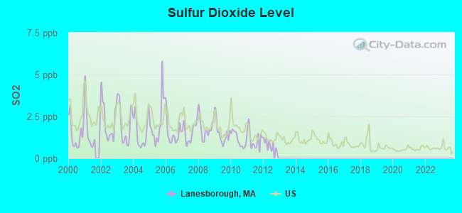
Sulfur Dioxide (SO2) [ppb] level in 2012 was 0.789. This is significantly better than average. Closest monitor was 4.0 miles away from the city center.
| City: | 0.789 |
| U.S.: | 1.515 |
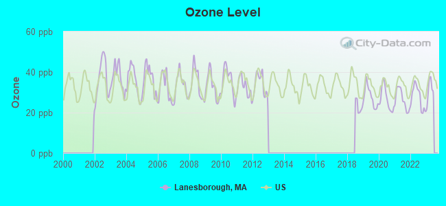
Ozone [ppb] level in 2022 was 27.5. This is better than average. Closest monitor was 4.0 miles away from the city center.
| City: | 27.5 |
| U.S.: | 33.3 |
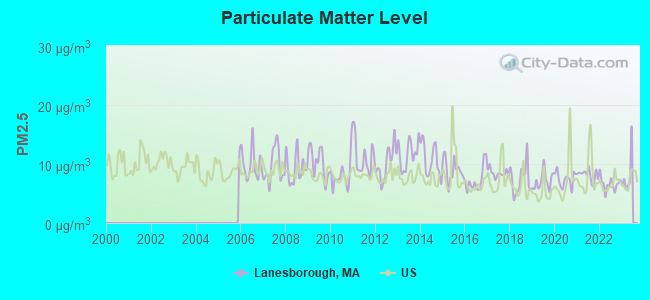
Particulate Matter (PM2.5) [µg/m3] level in 2022 was 6.63. This is better than average. Closest monitor was 4.8 miles away from the city center.
| City: | 6.63 |
| U.S.: | 8.11 |
Tornado activity:
Lanesborough-area historical tornado activity is slightly above Massachusetts state average. It is 22% smaller than the overall U.S. average.
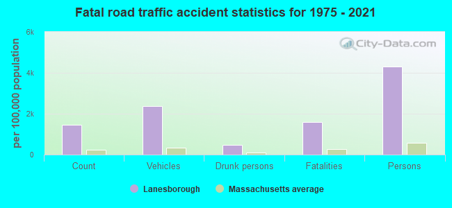
On 8/28/1973, a category F4 (max. wind speeds 207-260 mph) tornado 11.7 miles away from the Lanesborough town center killed 4 people and injured 36 people and caused between $5,000,000 and $50,000,000 in damages.
On 5/29/1995, a category F4 tornado 24.4 miles away from the town center killed 3 people and injured 24 people and caused between $5,000,000 and $50,000,000 in damages.
Earthquake activity:
Lanesborough-area historical earthquake activity is significantly above Massachusetts state average. It is 69% smaller than the overall U.S. average.On 10/7/1983 at 10:18:46, a magnitude 5.3 (5.1 MB, 5.3 LG, 5.1 ML, Class: Moderate, Intensity: VI - VII) earthquake occurred 113.5 miles away from the city center
On 4/20/2002 at 10:50:47, a magnitude 5.3 (5.3 ML, Depth: 3.0 mi) earthquake occurred 139.6 miles away from the city center
On 4/20/2002 at 10:50:47, a magnitude 5.2 (5.2 MB, 4.2 MS, 5.2 MW, 5.0 MW) earthquake occurred 138.0 miles away from Lanesborough center
On 1/19/1982 at 00:14:42, a magnitude 4.7 (4.5 MB, 4.7 MD, 4.5 LG, Class: Light, Intensity: IV - V) earthquake occurred 106.9 miles away from Lanesborough center
On 10/16/2012 at 23:12:25, a magnitude 4.7 (4.7 ML, Depth: 10.0 mi) earthquake occurred 150.1 miles away from the city center
On 6/17/1991 at 08:53:16, a magnitude 4.1 (4.0 MB, 4.0 LG, Depth: 3.1 mi) earthquake occurred 73.8 miles away from the city center
Magnitude types: regional Lg-wave magnitude (LG), body-wave magnitude (MB), duration magnitude (MD), local magnitude (ML), surface-wave magnitude (MS), moment magnitude (MW)
Natural disasters:
The number of natural disasters in Berkshire County (21) is greater than the US average (15).Major Disasters (Presidential) Declared: 10
Emergencies Declared: 10
Causes of natural disasters: Floods: 5, Snowstorms: 5, Storms: 5, Hurricanes: 4, Winter Storms: 4, Blizzards: 2, Snows: 2, Snowfall: 1, Tropical Storm: 1, Wind: 1, Other: 1 (Note: some incidents may be assigned to more than one category).
Hospitals and medical centers near Lanesborough:
- MT GREYLOCK EXTENDED CARE FACILITY (Nursing Home, about 4 miles away; PITTSFIELD, MA)
- BERKSHIRE MEDICAL CENTER INC Acute Care Hospitals (about 5 miles away; PITTSFIELD, MA)
- CRANEVILLE PLACE AT DALTON (Nursing Home, about 5 miles away; DALTON, MA)
- HILLCREST COMMONS NURSING AND REHABILITATION CENTER (Nursing Home, about 5 miles away; PITTSFIELD, MA)
- BERKSHIRE VISITING NURSE ASSOCIATION (Home Health Center, about 6 miles away; PITTSFIELD, MA)
- HILLCREST HOSPITAL (Hospital, about 6 miles away; PITTSFIELD, MA)
- BERKSHIRE PLACE (Nursing Home, about 6 miles away; PITTSFIELD, MA)
Colleges/universities with over 2000 students nearest to Lanesborough:
- Williams College (about 14 miles; Williamstown, MA; Full-time enrollment: 2,141)
- Hudson Valley Community College (about 26 miles; Troy, NY; FT enrollment: 9,346)
- Rensselaer Polytechnic Institute (about 27 miles; Troy, NY; FT enrollment: 6,940)
- The Sage Colleges (about 28 miles; Troy, NY; FT enrollment: 2,499)
- Siena College (about 30 miles; Loudonville, NY; FT enrollment: 3,153)
- The College of Saint Rose (about 30 miles; Albany, NY; FT enrollment: 4,085)
- SUNY at Albany (about 33 miles; Albany, NY; FT enrollment: 15,490)
Public elementary/middle school in Lanesborough:
- LANESBOROUGH ELEMENTARY (Students: 299, Location: 188 SUMMER STREET, Grades: PK-6)
Private elementary/middle school in Lanesborough:
Points of interest:
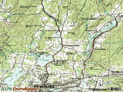
Notable locations in Lanesborough: Skyline Country Club (A), Lakeview Orchard (B), Camp Mohawk (C), Lanesborough Fire Department (D), Lanesborough Public Library (E), Lanesborough Town Hall (F). Display/hide their locations on the map
Shopping Center: Berkshire Mall Shopping Center (1). Display/hide its location on the map
Churches in Lanesborough include: Saint Lukes Church (A), Saint Lukes Episcopal Church (B), Saint Lukes Church (C). Display/hide their locations on the map
Cemeteries: Center Cemetery (1), Love of Peace Cemetery (2), Riverside Cemetery (3), Talcott Cemetery (4), Lanesborough Center Cemetery (5). Display/hide their locations on the map
Lake: Berkshire Pond (A). Display/hide its location on the map
Streams, rivers, and creeks: Town Brook (A), Secum Brook (B), Pettibone Brook (C), Muddy Brook (D), Hollow Brook (E). Display/hide their locations on the map
Park in Lanesborough: Balance Rock State Park (1). Display/hide its location on the map
Birthplace of: Henry Shaw Briggs - Union Army brigadier general, Josh Billings - (1818-1825), humorist, Bianca DeGroat - Actress.
Drinking water stations with addresses in Lanesborough and their reported violations in the past:
LANESBOROUGH FIRE WATER DISTRICT (Population served: 2,324, Purch surface water):Past health violations:GREYLOCK ESTATES HOMEOWNERS ASSOCIATION (Population served: 28, Groundwater):Past monitoring violations:
- MCL, Monthly (TCR) - In NOV-2012, Contaminant: Coliform. Follow-up actions: St AO (w/o penalty) issued (DEC-18-2012)
- MCL, Monthly (TCR) - In AUG-2010, Contaminant: Coliform. Follow-up actions: St AO (w/o penalty) issued (SEP-07-2010)
- MCL, Monthly (TCR) - In OCT-2009, Contaminant: Coliform. Follow-up actions: St AO (w/o penalty) issued (NOV-16-2009)
- MCL, Monthly (TCR) - In AUG-2009, Contaminant: Coliform. Follow-up actions: St AO (w/o penalty) issued (2 times from SEP-02-2009 to NOV-16-2009)
- 2 minor monitoring violations
Past health violations:
- MCL, Monthly (TCR) - In JUL-2013, Contaminant: Coliform. Follow-up actions: St AO (w/o penalty) issued (AUG-16-2013)
- MCL, Monthly (TCR) - In OCT-2012, Contaminant: Coliform. Follow-up actions: St AO (w/o penalty) issued (NOV-19-2012)
| This town: | 2.4 people |
| Massachusetts: | 2.5 people |
| This town: | 66.8% |
| Whole state: | 63.0% |
| This town: | 8.5% |
| Whole state: | 7.0% |
Likely homosexual households (counted as self-reported same-sex unmarried-partner households)
- Lesbian couples: 0.6% of all households
- Gay men: 0.2% of all households
| This town: | 5.7% |
| Whole state: | 9.3% |
| This town: | 2.0% |
| Whole state: | 4.4% |
4 people in homes for the mentally retarded in 2000
For population 15 years and over in Lanesborough:
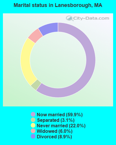
- Never married: 22.0%
- Now married: 59.9%
- Separated: 3.1%
- Widowed: 6.0%
- Divorced: 8.9%
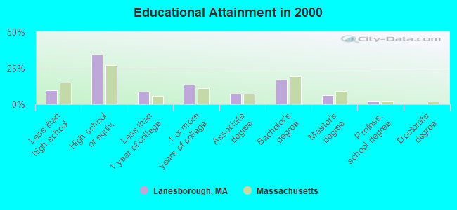
For population 25 years and over in Lanesborough:
- High school or higher: 90.3%
- Bachelor's degree or higher: 25.8%
- Graduate or professional degree: 9.0%
- Unemployed: 7.5%
- Mean travel time to work (commute): 19.6 minutes

| Here: | 9.4 |
| Massachusetts average: | 13.1 |


Graphs represent county-level data. Detailed 2008 Election Results
Religion statistics for Lanesborough, MA (based on Berkshire County data)


| Religion | Adherents | Congregations |
|---|---|---|
| Catholic | 50,187 | 32 |
| Mainline Protestant | 9,895 | 63 |
| Other | 3,647 | 20 |
| Evangelical Protestant | 2,817 | 28 |
| Black Protestant | 233 | 2 |
| Orthodox | 225 | 2 |
| None | 64,215 | - |
Food Environment Statistics:
| Here: | 2.54 / 10,000 pop. |
| State: | 1.98 / 10,000 pop. |
| Berkshire County: | 1.61 / 10,000 pop. |
| Massachusetts: | 2.22 / 10,000 pop. |
| Here: | 4.08 / 10,000 pop. |
| Massachusetts: | 1.77 / 10,000 pop. |
| This county: | 15.00 / 10,000 pop. |
| Massachusetts: | 8.76 / 10,000 pop. |
| This county: | 8.0% |
| State: | 8.1% |
| Here: | 22.8% |
| Massachusetts: | 22.5% |
| Berkshire County: | 9.9% |
| Massachusetts: | 16.5% |
| Businesses in Lanesborough, MA | ||||
| Name | Count | Name | Count | |
|---|---|---|---|---|
| AT&T | 1 | Motherhood Maternity | 1 | |
| American Eagle Outfitters | 1 | New York & Co | 1 | |
| Bath & Body Works | 1 | RadioShack | 1 | |
| Deb | 1 | Spencer Gifts | 1 | |
| JCPenney | 1 | Subway | 1 | |
| Macy's | 1 | Vans | 1 | |
Strongest AM radio stations in Lanesborough:
- WUHN (1110 AM; daytime; 5 kW; PITTSFIELD, MA; Owner: WEINER BROADCASTING, INC.)
- WNNZ (640 AM; 50 kW; WESTFIELD, MA; Owner: CLEAR CHANNEL BROADCASTING LICENSES, INC.)
- WGY (810 AM; 50 kW; SCHENECTADY, NY; Owner: CLEAR CHANNEL BROADCASTING LICENSES, INC.)
- WBRK (1340 AM; 1 kW; PITTSFIELD, MA; Owner: WBRK, INC.)
- WPTR (1540 AM; 50 kW; ALBANY, NY; Owner: KIMTRON, INC.)
- WBEC (1420 AM; 1 kW; PITTSFIELD, MA; Owner: GREAT NORTHERN RADIO, LLC)
- WTIC (1080 AM; 50 kW; HARTFORD, CT; Owner: INFINITY RADIO OPERATIONS INC.)
- WCRN (830 AM; 50 kW; WORCESTER, MA; Owner: CARTER BROADCASTING CORPORATION)
- WROW (590 AM; 5 kW; ALBANY, NY; Owner: 6 JOHNSON ROAD LICENSES, INC.)
- WVNE (760 AM; daytime; 25 kW; LEICESTER, MA; Owner: BLOUNT MASSCOM, INC.)
- WRKO (680 AM; 50 kW; BOSTON, MA; Owner: ENTERCOM BOSTON LICENSE, LLC)
- WSBS (860 AM; 3 kW; GREAT BARRINGTON, MA; Owner: BERKSHIRE BROADCASTING CO., INC.)
- WIZZ (1520 AM; daytime; 10 kW; GREENFIELD, MA; Owner: P. & M. RADIO, LLC)
Strongest FM radio stations in Lanesborough:
- WAMC-FM (90.3 FM; ALBANY, NY; Owner: WAMC)
- WBEC-FM (105.5 FM; PITTSFIELD, MA; Owner: GREAT NORTHERN RADIO, LLC)
- WUPE (95.9 FM; PITTSFIELD, MA; Owner: WEINER BROADCASTING, INC.)
- WBRK-FM (101.7 FM; PITTSFIELD, MA; Owner: WBRK, INC.)
- WZEC (97.5 FM; HOOSICK FALLS, NY; Owner: GREAT NORTHERN RADIO, LLC)
- WHVP (91.1 FM; HUDSON, NY; Owner: SOUND OF LIFE, INC.)
- WEQX (102.7 FM; MANCHESTER, VT; Owner: NORTHSHIRE COMMUNICATIONS, INC.)
- WJAN (95.1 FM; SUNDERLAND, VT; Owner: 6 JOHNSON ROAD LICENSES, INC.)
- WMNB (100.1 FM; NORTH ADAMS, MA; Owner: BERKSHIRE BROADCASTING CO., INC.)
- WVAY (100.7 FM; WILMINGTON, VT; Owner: GREAT NORTHERN RADIO, L.L.C.)
- WAMQ (105.1 FM; GREAT BARRINGTON, MA; Owner: WAMC)
- WHYN-FM (93.1 FM; SPRINGFIELD, MA; Owner: CLEAR CHANNEL BROADCASTING LICENSES, INC.)
- WAJZ (96.3 FM; VOORHEESVILLE, NY; Owner: 6 JOHNSON ROAD LICENSES, INC.)
- WZMR (104.9 FM; ALTAMONT, NY; Owner: 6 JOHNSON ROAD LICENSES, INC.)
- WRNX (100.9 FM; AMHERST, MA; Owner: WESTERN MASSACHUSETTS RADIO COMPANY)
- WYJB (95.5 FM; ALBANY, NY; Owner: 6 JOHNSON ROAD LICENSES, INC.)
- WAMK (90.9 FM; KINGSTON, NY; Owner: W A M C)
- WGNA-FM (107.7 FM; ALBANY, NY; Owner: REGENT LICENSEE OF MANSFIELD, INC.)
- WFGB (89.7 FM; KINGSTON, NY; Owner: SOUND OF LIFE, INC.)
- WPVQ (95.3 FM; GREENFIELD, MA; Owner: GREAT NORTHERN RADIO, L.L.C.)
TV broadcast stations around Lanesborough:
- WCDC-TV (Channel 19; ADAMS, MA; Owner: YOUNG BROADCASTING OF ALBANY, INC.)
- W38DL (Channel 38; ADAMS, ETC., MA; Owner: WNYT-TV, LLC)
- WNGN-LP (Channel 26; TROY, NY; Owner: BRIAN A. LARSON)
- W35BK (Channel 35; PLAINFIELD, MA; Owner: LYDIA SYLVANE STOCKWELL)
- W07AI (Channel 7; PITTSFIELD, ETC., MA; Owner: WNYT-TV, LLC)
- National Bridge Inventory (NBI) Statistics
- 14Number of bridges
- 59ft / 17.9mTotal length
- $11,321,000Total costs
- 51,387Total average daily traffic
- 4,274Total average daily truck traffic
- New bridges - historical statistics
- 11930-1939
- 21940-1949
- 51960-1969
- 31980-1989
- 32010-2019
FCC Registered Broadcast Land Mobile Towers:
2- Lat: 42.505000 Lon: -73.197000, Call Sign: WQEZ889,
Assigned Frequencies: 461.587 MHz, 461.712 MHz, 461.837 MHz, 466.962 MHz, 467.225 MHz, Grant Date: 04/02/2016, Expiration Date: 05/30/2026, Certifier: Lisa Monnig, Registrant: Bearcom Operating LLC, ., Dallas, TX 75355-9001, Phone: (800) 458-9887, Fax: (214) 355-1713, Email:
- Bridge St. (Lat: 42.521417 Lon: -73.231472), Type: Bant, Structure height: 6.1 m, Overall height: 9.1 m, Call Sign: WQRA492,
Assigned Frequencies: 218.500 MHz, Grant Date: 04/04/2013, Expiration Date: 04/04/2023, Cancellation Date: 06/10/2023, Certifier: Dave Santolin, Registrant: Atlas License Company & Data Services, 7202 N. Shadeland Ave Ste 215, Indianapolis, IN 46250, Phone: (317) 813-4865, Fax: (317) 813-4870, Email:
FCC Registered Amateur Radio Licenses:
4- Call Sign: W1GG, Licensee ID: L00167735, Grant Date: 01/19/2006, Expiration Date: 04/04/2016, Cancellation Date: 05/22/2009, Certifier: Gareth B Gaudette, Registrant: Gareth B Gaudette, 21 Westview Rd, Lanesborough, MA 01237
- Call Sign: AC7XQ, Previous Call Sign: KD7MXL, Licensee ID: L00350597, Grant Date: 01/27/2021, Expiration Date: 04/25/2031, Certifier: David J Childs, Registrant: David J Childs, Lanesborough, MA 01237
- Call Sign: KC1ADG, Licensee ID: L01790030, Grant Date: 03/28/2023, Expiration Date: 06/24/2033, Certifier: Thomas M Weber, Registrant: Thomas M Weber, 65 Swamp Rd, Lanesborough, MA 01237
- Call Sign: KC1IXV, Licensee ID: L02157703, Grant Date: 01/30/2018, Expiration Date: 01/30/2028, Cancellation Date: 04/03/2018, Certifier: Andrew J Whitaker, Registrant: Andrew J Whitaker, 495 Williamstown Road, Lanesborough, MA 01237
2002 - 2016 National Fire Incident Reporting System (NFIRS) incidents
- Fire incident types reported to NFIRS in Lanesborough, MA
- 5736.1%Outside Fires
- 5434.2%Structure Fires
- 2415.2%Other
- 2314.6%Mobile Property/Vehicle Fires
 Based on the data from the years 2002 - 2016 the average number of fires per year is 11. The highest number of fire incidents - 25 took place in 2005, and the least - 0 in 2003. The data has a declining trend.
 When looking into fire subcategories, the most reports belonged to: Outside Fires (36.1%), and Structure Fires (34.2%).
- 63.3%Fuel oil, kerosene, etc.
- 13.7%Bottled, tank, or LP gas
- 9.0%Utility gas
- 6.7%Electricity
- 6.1%Wood
- 0.6%Coal or coke
- 0.6%Other fuel
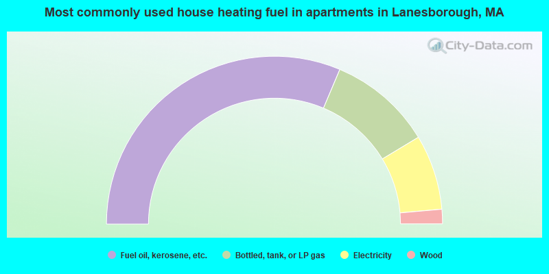
- 62.8%Fuel oil, kerosene, etc.
- 20.0%Bottled, tank, or LP gas
- 14.5%Electricity
- 2.8%Wood
Lanesborough compared to Massachusetts state average:
- Median house value below state average.
- Unemployed percentage below state average.
- Black race population percentage significantly below state average.
- Hispanic race population percentage significantly below state average.
- Median age above state average.
- Foreign-born population percentage significantly below state average.
- Renting percentage significantly below state average.
- Length of stay since moving in significantly above state average.
- Number of rooms per house significantly below state average.
- House age significantly below state average.

|
|
Total of 11 patent applications in 2008-2024.