Keene, New Hampshire

Keene: Central Square, Winter 2008

Keene: Center of Keene

Keene: Pond in Robin Hood Park, Keene NH
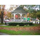
Keene: Center of Keene

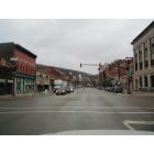
Keene: Central Square businesses
Keene
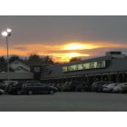
Keene: Toy City

Keene: Keene Pumpkin Festival
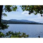
Keene: Mt. Manadnock From Dublin Lake

Keene: Panorama of Otter Brook Dam
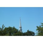
Keene: Church Steeple of Keene, NH
- see
14
more - add
your
Submit your own pictures of this city and show them to the world
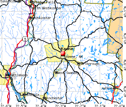
- OSM Map
- General Map
- Google Map
- MSN Map
Population change since 2000: +0.9%
 |
| Males: 11,271 | |
| Females: 11,503 |
| Median resident age: | 36.3 years |
| New Hampshire median age: | 43.3 years |
Zip codes: 03431.
| Keene: | $70,474 |
| NH: | $89,992 |
Estimated per capita income in 2022: $39,312 (it was $20,544 in 2000)
Keene city income, earnings, and wages data
Estimated median house or condo value in 2022: $250,048 (it was $100,800 in 2000)
| Keene: | $250,048 |
| NH: | $384,700 |
Mean prices in 2022: all housing units: $257,905; detached houses: $276,462; townhouses or other attached units: $193,146; in 2-unit structures: $274,554; in 5-or-more-unit structures: $227,960; mobile homes: $29,856
Median gross rent in 2022: $1,052.
(11.4% for White Non-Hispanic residents, 10.2% for Black residents, 4.2% for Hispanic or Latino residents, 18.2% for American Indian residents, 10.2% for other race residents, 6.3% for two or more races residents)
Detailed information about poverty and poor residents in Keene, NH


- 20,97590.7%White alone
- 9364.0%Two or more races
- 5932.6%Hispanic
- 2841.2%Black alone
- 2571.1%Asian alone
- 1260.5%Other race alone
- 100.04%American Indian alone
- 70.03%Native Hawaiian and Other
Pacific Islander alone
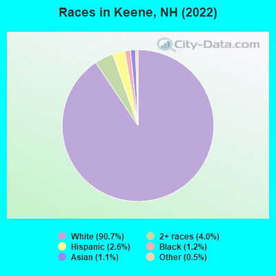
Races in Keene detailed stats: ancestries, foreign born residents, place of birth
According to our research of New Hampshire and other state lists, there were 33 registered sex offenders living in Keene, New Hampshire as of May 03, 2024.
The ratio of all residents to sex offenders in Keene is 717 to 1.
The ratio of registered sex offenders to all residents in this city is lower than the state average.
Type |
2009 |
2010 |
2011 |
2012 |
2013 |
2014 |
2015 |
2016 |
2017 |
2018 |
2019 |
2020 |
2021 |
2022 |
|---|---|---|---|---|---|---|---|---|---|---|---|---|---|---|
| Murders (per 100,000) | 0 (0.0) | 0 (0.0) | 1 (4.3) | 0 (0.0) | 1 (4.3) | 1 (4.3) | 0 (0.0) | 0 (0.0) | 0 (0.0) | 0 (0.0) | 0 (0.0) | 0 (0.0) | 0 (0.0) | 1 (4.3) |
| Rapes (per 100,000) | 12 (53.6) | 11 (47.0) | 10 (42.7) | 7 (29.9) | 13 (55.9) | 17 (72.6) | 14 (61.0) | 15 (64.5) | 11 (47.0) | 14 (61.2) | 17 (73.9) | 15 (66.1) | 15 (66.3) | 18 (77.3) |
| Robberies (per 100,000) | 17 (76.0) | 12 (51.3) | 15 (64.0) | 13 (55.6) | 23 (99.0) | 18 (76.9) | 14 (61.0) | 15 (64.5) | 19 (81.2) | 9 (39.4) | 12 (52.2) | 8 (35.2) | 4 (17.7) | 11 (47.3) |
| Assaults (per 100,000) | 21 (93.9) | 23 (98.3) | 27 (115.2) | 44 (188.0) | 33 (142.0) | 28 (119.6) | 35 (152.5) | 27 (116.2) | 26 (111.2) | 24 (104.9) | 15 (65.2) | 14 (61.7) | 8 (35.4) | 10 (43.0) |
| Burglaries (per 100,000) | 98 (438.0) | 89 (380.2) | 127 (541.8) | 114 (487.2) | 107 (460.5) | 173 (739.1) | 97 (422.7) | 95 (408.7) | 83 (354.9) | 38 (166.2) | 31 (134.8) | 34 (149.7) | 28 (123.8) | 26 (111.7) |
| Thefts (per 100,000) | 686 (3,066) | 704 (3,007) | 669 (2,854) | 690 (2,949) | 970 (4,175) | 740 (3,161) | 657 (2,863) | 566 (2,435) | 576 (2,463) | 511 (2,234) | 437 (1,900) | 353 (1,555) | 346 (1,530) | 452 (1,942) |
| Auto thefts (per 100,000) | 34 (151.9) | 14 (59.8) | 16 (68.3) | 29 (123.9) | 17 (73.2) | 20 (85.4) | 13 (56.6) | 16 (68.8) | 20 (85.5) | 11 (48.1) | 23 (100.0) | 11 (48.4) | 14 (61.9) | 20 (85.9) |
| Arson (per 100,000) | 6 (26.8) | 6 (25.6) | 2 (8.5) | 4 (17.1) | 6 (25.8) | 4 (17.1) | 6 (26.1) | 2 (8.6) | 3 (12.8) | 1 (4.4) | 0 (0.0) | 2 (8.8) | 2 (8.8) | 3 (12.9) |
| City-Data.com crime index | 249.9 | 224.3 | 242.4 | 240.2 | 316.5 | 298.7 | 246.2 | 225.7 | 214.4 | 186.6 | 181.3 | 152.3 | 140.2 | 185.6 |
The City-Data.com crime index weighs serious crimes and violent crimes more heavily. Higher means more crime, U.S. average is 246.1. It adjusts for the number of visitors and daily workers commuting into cities.

Crime rate in Keene detailed stats: murders, rapes, robberies, assaults, burglaries, thefts, arson
Full-time law enforcement employees in 2021, including police officers: 49 (39 officers - 35 male; 4 female).
| Officers per 1,000 residents here: | 1.72 |
| New Hampshire average: | 2.14 |
 Recent articles from our blog. Our writers, many of them Ph.D. graduates or candidates, create easy-to-read articles on a wide variety of topics.

 | Keene - The good, the bad and the ugly (26 replies) |
| Best town around Keene? Chesterfield, Winchester, Spofford? (5 replies) |
| Keene - Mill Colony Loft/Apartments (0 replies) |
| Moving to New Hampshire (Lebanon, Hanover, Keene, Grantham, Plainfield, Enfield, Etna) (38 replies) |
| Moving to Keene area or Walpole. Please advise. (13 replies) |
| Possible move to Keene NH (18 replies) |
Latest news from Keene, NH collected exclusively by city-data.com from local newspapers, TV, and radio stations
Ancestries: English (15.4%), Irish (14.9%), French Canadian (12.2%), Italian (8.4%), French (7.0%), European (5.9%).
Current Local Time: EST time zone
Incorporated in 1753
Elevation: 486 feet
Land area: 37.3 square miles.
Population density: 610 people per square mile (low).
970 residents are foreign born (1.3% Europe, 1.2% Asia, 0.7% Africa, 0.5% North America).
| This city: | 4.2% |
| New Hampshire: | 6.0% |
Median real estate property taxes paid for housing units with mortgages in 2022: $6,398 (2.5%)
Median real estate property taxes paid for housing units with no mortgage in 2022: $5,838 (2.4%)
Nearest city with pop. 50,000+: Manchester, NH  (42.5 miles , pop. 107,006).
Nearest city with pop. 200,000+: Boston, MA (74.6 miles , pop. 589,141).
Nearest city with pop. 1,000,000+: Bronx, NY (166.3 miles , pop. 1,332,650).
Nearest cities:
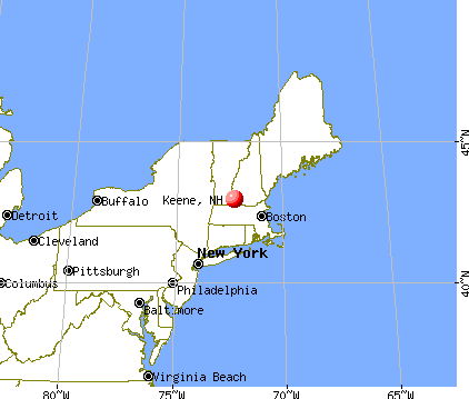
), ), Latitude: 42.94 N, Longitude: 72.29 W
Daytime population change due to commuting: +7,573 (+32.7%)
Workers who live and work in this city: 8,608 (74.1%)
Area code: 603
Keene, New Hampshire accommodation & food services, waste management - Economy and Business Data
Single-family new house construction building permits:
- 2022: 14 buildings, average cost: $544,200
- 2021: 2 buildings, average cost: $235,000
- 2020: 3 buildings, average cost: $121,000
- 2019: 7 buildings, average cost: $120,900
- 2018: 4 buildings, average cost: $95,000
- 2016: 4 buildings, average cost: $116,000
- 2015: 4 buildings, average cost: $227,500
- 2014: 1 building, cost: $200,000
- 2013: 6 buildings, average cost: $156,800
- 2012: 5 buildings, average cost: $191,000
- 2011: 11 buildings, average cost: $209,800
- 2010: 15 buildings, average cost: $209,800
- 2009: 11 buildings, average cost: $209,800
- 2008: 15 buildings, average cost: $209,700
- 2007: 22 buildings, average cost: $210,200
- 2006: 26 buildings, average cost: $207,700
- 2005: 26 buildings, average cost: $221,600
- 2004: 37 buildings, average cost: $170,100
- 2003: 33 buildings, average cost: $169,300
- 2002: 29 buildings, average cost: $173,300
- 2001: 24 buildings, average cost: $189,000
- 2000: 23 buildings, average cost: $128,800
- 1999: 38 buildings, average cost: $110,400
- 1998: 28 buildings, average cost: $173,900
- 1997: 11 buildings, average cost: $84,700
| Here: | 2.5% |
| New Hampshire: | 2.5% |
- Educational services (12.9%)
- Health care (8.3%)
- Accommodation & food services (7.2%)
- Finance & insurance (6.8%)
- Metal & metal products (4.7%)
- Construction (4.6%)
- Professional, scientific, technical services (4.1%)
- Educational services (8.9%)
- Construction (8.6%)
- Accommodation & food services (7.2%)
- Metal & metal products (6.6%)
- Finance & insurance (5.1%)
- Machinery (4.1%)
- Professional, scientific, technical services (4.1%)
- Educational services (16.9%)
- Health care (13.7%)
- Finance & insurance (8.6%)
- Accommodation & food services (7.1%)
- Social assistance (4.6%)
- Professional, scientific, technical services (4.1%)
- Miscellaneous manufacturing (3.9%)
- Retail sales workers, except cashiers (4.7%)
- Other sales and related occupations, including supervisors (4.6%)
- Other office and administrative support workers, including supervisors (4.3%)
- Other management occupations, except farmers and farm managers (4.1%)
- Preschool, kindergarten, elementary, and middle school teachers (3.1%)
- Other production occupations, including supervisors (3.1%)
- Material recording, scheduling, dispatching, and distributing workers (3.0%)
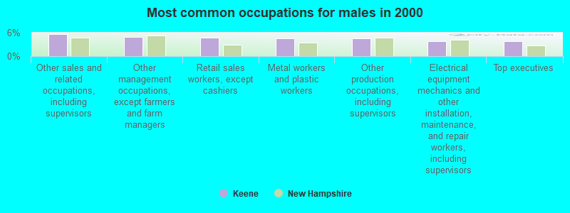
- Other sales and related occupations, including supervisors (5.7%)
- Other management occupations, except farmers and farm managers (4.9%)
- Retail sales workers, except cashiers (4.8%)
- Metal workers and plastic workers (4.5%)
- Other production occupations, including supervisors (4.5%)
- Electrical equipment mechanics and other installation, maintenance, and repair workers, including supervisors (3.8%)
- Top executives (3.7%)
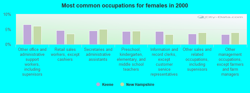
- Other office and administrative support workers, including supervisors (6.6%)
- Retail sales workers, except cashiers (4.6%)
- Secretaries and administrative assistants (4.5%)
- Preschool, kindergarten, elementary, and middle school teachers (4.4%)
- Information and record clerks, except customer service representatives (4.3%)
- Other sales and related occupations, including supervisors (3.5%)
- Other management occupations, except farmers and farm managers (3.3%)
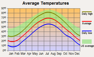
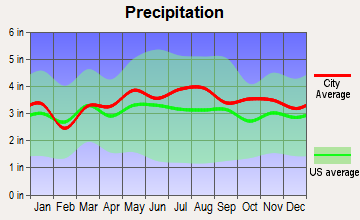
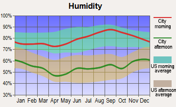
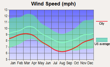
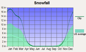
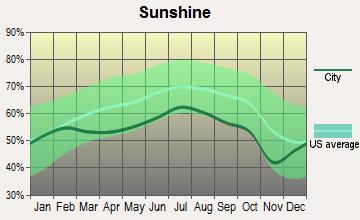
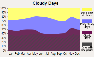
Average climate in Keene, New Hampshire
Based on data reported by over 4,000 weather stations
|
|

(lower is better)
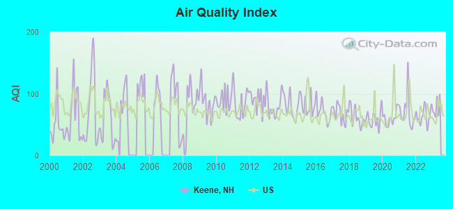
Air Quality Index (AQI) level in 2022 was 64.4. This is about average.
| City: | 64.4 |
| U.S.: | 72.6 |

Carbon Monoxide (CO) [ppm] level in 2022 was 0.131. This is significantly better than average. Closest monitor was 1.2 miles away from the city center.
| City: | 0.131 |
| U.S.: | 0.251 |
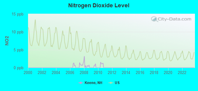
Nitrogen Dioxide (NO2) [ppb] level in 2007 was 1.02. This is significantly better than average. Closest monitor was 0.7 miles away from the city center.
| City: | 1.02 |
| U.S.: | 5.11 |
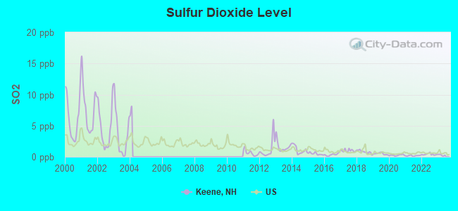
Sulfur Dioxide (SO2) [ppb] level in 2022 was 0.411. This is significantly better than average. Closest monitor was 0.7 miles away from the city center.
| City: | 0.411 |
| U.S.: | 1.515 |
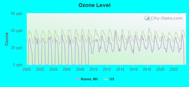
Ozone [ppb] level in 2022 was 23.7. This is significantly better than average. Closest monitor was 0.7 miles away from the city center.
| City: | 23.7 |
| U.S.: | 33.3 |
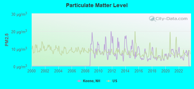
Particulate Matter (PM2.5) [µg/m3] level in 2022 was 5.97. This is better than average. Closest monitor was 1.2 miles away from the city center.
| City: | 5.97 |
| U.S.: | 8.11 |
Tornado activity:
Keene-area historical tornado activity is above New Hampshire state average. It is 27% smaller than the overall U.S. average.
On 6/9/1953, a category F4 (max. wind speeds 207-260 mph) tornado 33.2 miles away from the Keene city center killed 90 people and injured 1228 people and caused between $50,000,000 and $500,000,000 in damages.
On 8/20/1968, a category F3 (max. wind speeds 158-206 mph) tornado 28.1 miles away from the city center injured one person and caused between $5000 and $50,000 in damages.
Earthquake activity:
Keene-area historical earthquake activity is significantly above New Hampshire state average. It is 70% smaller than the overall U.S. average.On 10/7/1983 at 10:18:46, a magnitude 5.3 (5.1 MB, 5.3 LG, 5.1 ML, Class: Moderate, Intensity: VI - VII) earthquake occurred 124.6 miles away from the city center
On 4/20/2002 at 10:50:47, a magnitude 5.3 (5.3 ML, Depth: 3.0 mi) earthquake occurred 129.4 miles away from Keene center
On 4/20/2002 at 10:50:47, a magnitude 5.2 (5.2 MB, 4.2 MS, 5.2 MW, 5.0 MW) earthquake occurred 128.5 miles away from Keene center
On 1/19/1982 at 00:14:42, a magnitude 4.7 (4.5 MB, 4.7 MD, 4.5 LG, Class: Light, Intensity: IV - V) earthquake occurred 51.9 miles away from the city center
On 10/16/2012 at 23:12:25, a magnitude 4.7 (4.7 ML, Depth: 10.0 mi) earthquake occurred 93.9 miles away from the city center
On 10/2/1994 at 11:27:22, a magnitude 3.7 (3.5 LG, 3.7 LG, Depth: 6.2 mi, Class: Light, Intensity: II - III) earthquake occurred 41.2 miles away from Keene center
Magnitude types: regional Lg-wave magnitude (LG), body-wave magnitude (MB), duration magnitude (MD), local magnitude (ML), surface-wave magnitude (MS), moment magnitude (MW)
Natural disasters:
The number of natural disasters in Cheshire County (27) is a lot greater than the US average (15).Major Disasters (Presidential) Declared: 16
Emergencies Declared: 11
Causes of natural disasters: Floods: 11, Storms: 11, Snows: 4, Snowstorms: 3, Winter Storms: 3, Hurricanes: 2, Blizzard: 1, Heavy Rain: 1, Ice Storm: 1, Landslide: 1, Snowfall: 1, Tropical Storm: 1, Wind: 1, Other: 1 (Note: some incidents may be assigned to more than one category).
Hospitals and medical centers in Keene:
- CEDARCREST INC (91 MAPLE AVENUE)
- CHESHIRE MEDICAL CENTER (Voluntary non-profit - Private, provides emergency services, 580 COURT STREET)
- HOSPICE OF THE MONADNOCK REGION (7 CENTER ST)
- KEENE CENTER, GENESIS HEALTHCARE (677 COURT STREET)
- LANGDON PLACE OF KEENE NURSING (136 A ARCH STREET)
- SNF CHESHIRE MEDICAL CTR. (580 COURT ST)
- WESTWOOD CARE AND REHABILITATION CENTER (298 MAIN STREET)
- MONADNOCK DIALYSIS CENTER (426B WINCHESTER STREET)
- VNA AT HCS INC (312 MARLBOROUGH STREET)
Airports and heliports located in Keene:
- Dillant-Hopkins Airport (EEN) (Runways: 2, Air Taxi Ops: 7,204, Itinerant Ops: 7,456, Local Ops: 31,053, Military Ops: 3,314)
- Cheshire Medical Center Heliport (14NH)
Amtrak stations near Keene:
- 16 miles: BRATTLEBORO (VERNON RD.) . Services: enclosed waiting area, public restrooms, call for car rental service, call for taxi service.
- 16 miles: BELLOWS FALLS (DEPOT ST.) . Services: enclosed waiting area, public restrooms, public payphones, free short-term parking, free long-term parking, call for taxi service.
Operable nuclear power plant near Keene:
- 17 miles: Vermont Yankee in Vernon, VT.
Colleges/Universities in Keene:
- Keene State College (Full-time enrollment: 5,098; Location: 229 Main Street; Public; Website: www.keene.edu; Offers Master's degree)
- Antioch University-New England (Full-time enrollment: 360; Location: 40 Avon St; Private, not-for-profit; Website: www.antiochne.edu; Offers Doctor's degree)
- Keene Beauty Academy (Full-time enrollment: 50; Location: 800 Park Ave; Private, for-profit; Website: WWW.KEENEBEAUTYACADEMY.edu)
Other colleges/universities with over 2000 students near Keene:
- Franklin Pierce University (about 17 miles; Rindge, NH; Full-time enrollment: 2,139)
- Mount Wachusett Community College (about 29 miles; Gardner, MA; FT enrollment: 3,143)
- Fitchburg State University (about 36 miles; Fitchburg, MA; FT enrollment: 5,010)
- Saint Anselm College (about 40 miles; Manchester, NH; FT enrollment: 2,059)
- University of Massachusetts-Amherst (about 41 miles; Amherst, MA; FT enrollment: 26,583)
- Mount Washington College (about 42 miles; Manchester, NH; FT enrollment: 2,187)
- Southern New Hampshire University (about 43 miles; Manchester, NH; FT enrollment: 16,552)
Public high school in Keene:
- KEENE HIGH SCHOOL (Students: 1,788, Location: 43 ARCH ST., Grades: 9-12)
Private high schools in Keene:
- MONADNOCK WALDORF SCHOOL (Students: 201, Location: 98 S LINCOLN ST, Grades: PK-11)
- CEDARCREST SCHOOL (Students: 20, Location: 91 MAPLE AVE, Grades: PK-12)
Public elementary/middle schools in Keene:
- KEENE MIDDLE SCHOOL (Students: 726, Location: 167 MAPLE AVE., Grades: 6-8)
- SYMONDS ELEMENTARY SCHOOL (Students: 321, Location: 79 PARK AVE., Grades: KG-5)
- FULLER ELEMENTARY SCHOOL (Students: 277, Location: 422 ELM ST., Grades: KG-5)
- FRANKLIN ELEMENTARY SCHOOL (Students: 201, Location: 217 WASHINGTON ST., Grades: KG-5)
- WHEELOCK ELEMENTARY SCHOOL (Students: 198, Location: 24 ADAMS ST., Grades: PK-5)
- JONATHAN M. DANIELS SCHOOL (Students: 177, Location: 179 MAPLE AVE., Grades: KG-5)
Private elementary/middle schools in Keene:
- ST JOSEPH REGIONAL SCHOOL (Students: 120, Location: 92 WILSON ST, Grades: PK-8)
- TRINITY CHRISTIAN SCHOOL (Students: 120, Location: 100 MAPLE AVE, Grades: PK-8)
User-submitted facts and corrections:
- Franklin Pierce College- 1 campus in Keene for Graduate and Professional Studies. 1 campus near Keene, located in Rindge NH. Approx. 1548 students. About 20 miles away.
Points of interest:
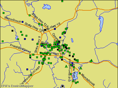
Notable locations in Keene: Camp Wakonda (A), Keene Country Club (B), Keene Municipal Pool (C), Keene Municipal Swimming Pool (D), Keene Industrial Park (E), Elks Camp (F), Bretwood Golf Course (G), Bradco Industrial Park (H), Black Brook Corporate Park (I), Wallace E Mason Library (J), United Church of Christ Library (K), Thayer Library (L), Senior Citizens Center (M), Masonic Temple (N), Keene City Hall (O), Historical Society of Cheshire County (P), Greater Keene Chamber of Commerce (Q), Colony House Museum (R), Cheshire Medical Center Library (S), Cheshire County Courthouse (T). Display/hide their locations on the map
Shopping Centers: Riverside Plaza Shopping Center (1), West Street Shopping Center (2), Fairbanks Plaza Shopping Center (3), Colony Mill Marketplace Shopping Center (4). Display/hide their locations on the map
Churches in Keene include: Congregation Ahavas Achim (A), First Baptist Church of Keene (B), First Church of Christ Scientist (C), Grace United Methodist Church (D), Saint Bernards Church (E), Saint George Greek Orthodox Church (F), Saint James Episcopal Church (G), Saint Margaret Mary Parish Church (H), Seventh Day Adventist Church (I). Display/hide their locations on the map
Cemeteries: Greenlawn Cemetery (1), North Cemetery (2), West Cemetery (3), Woodland Cemetery (4), Saint Josephs Cemetery (5), Monadnock View Cemetery (6). Display/hide their locations on the map
Lakes, reservoirs, and swamps: Wilson Pond (A), Ashuelot River Reservoir (B), Robinhood Park Reservoir (C), Goose Pond (D), Shadow Lake (E), Tenant Swamp (F). Display/hide their locations on the map
Streams, rivers, and creeks: Sturtevant Brook (A), The Branch (B), White Brook (C), Otter Brook (D), New Run Brook (E), Minnewawa Brook (F), Hurricane Brook (G), Hart Brook (H), Grimes Brook (I). Display/hide their locations on the map
Parks in Keene include: Robin Hood Forest (1), Ladies Park (2), Keene State College Soccer Field (3), Keene City Park (4), Joyce Athletic Field (5), Horatio Colony Trust (6), Drummer Hill Preserve (7), Childrens Wood (8), Central Square (9). Display/hide their locations on the map
Tourist attractions: Weldon Tom & Anita (Museums; 199 Main Street) (1), Horatio Colony Museum (199 Main Street) (2), Monadnock Travel Council (315 Washington Street) (3), General Tours (Tours & Charters; 53 Summer Street) (4). Display/hide their approximate locations on the map
Hotels: Valley Green Motel (379 West Street) (1), Holiday Inn Express Keene (175 Key Road) (2), Super 8 Keene NH (3 Ashbrook Road) (3), Wright Mansion Inn (695 Court) (4). Display/hide their approximate locations on the map
Courts: Emerald Court Office (55 Main Street) (1), Keene District Court (3 Washington Street) (2), Pricechopper Food Court (16 Ash Brook Road) (3), Court Referral Program (103 Roxbury Street Suite 206) (4). Display/hide their approximate locations on the map
Birthplace of: Heather Wilson - Politician, A. G. Lafley - Chief executive, Amos Foster - Football player and coach, Charles Dinsmoor - Lawyer, Jonathan Daniels - African s' rights activist, Dick Wheeler - Baseball player, Ryan Moore (soccer) - Soccer player, John Bosa - Football player.
Drinking water stations with addresses in Keene and their reported violations in the past:
KEENE WATER DEPT (Population served: 25,000, Surface water):Past health violations:CHESHIRE COUNTY COMPLEX (Population served: 480, Surface water):Past monitoring violations:
- MCL, Monthly (TCR) - In AUG-2009, Contaminant: Coliform. Follow-up actions: St Violation/Reminder Notice (AUG-12-2009), St Public Notif requested (AUG-12-2009), St Public Notif received (SEP-15-2009), St Compliance achieved (FEB-16-2010)
- Single Turbidity Exceed (Enhanced SWTR) - Between NOV-01-2012 and DEC-01-2012, Contaminant: IESWTR. Follow-up actions: St Public Notif requested (NOV-29-2012), St Violation/Reminder Notice (NOV-29-2012), St Public Notif received (DEC-18-2012), St Compliance achieved (JUL-23-2013)
- Single Turbidity Exceed (Enhanced SWTR) - Between SEP-01-2012 and OCT-01-2012, Contaminant: IESWTR. Follow-up actions: St Public Notif requested (NOV-14-2012), St Violation/Reminder Notice (NOV-14-2012), St Public Notif received (DEC-17-2012), St Compliance achieved (JUL-23-2013)
- Single Turbidity Exceed (Enhanced SWTR) - Between JUL-01-2012 and AUG-01-2012, Contaminant: IESWTR. Follow-up actions: St Public Notif requested (AUG-10-2012), St Violation/Reminder Notice (AUG-10-2012), St Public Notif received (AUG-24-2012), St Compliance achieved (JUL-23-2013)
- Monitoring, Source Water (GWR) - Between OCT-01-2011 and NOV-01-2011, Contaminant: E. COLI. Follow-up actions: St Public Notif requested (NOV-28-2011), St Violation/Reminder Notice (NOV-28-2011), St Compliance achieved (NOV-28-2011), St Public Notif received (NOV-16-2012)
- Single Turbidity Exceed (Enhanced SWTR) - Between MAR-01-2011 and APR-01-2011, Contaminant: IESWTR. Follow-up actions: St Public Notif requested (APR-26-2011), St Violation/Reminder Notice (APR-26-2011), St Public Notif received (APR-23-2012), St Compliance achieved (APR-23-2012)
- 2 regular monitoring violations
- 3 other older monitoring violations
Past health violations:PINE GROVE MOBILE HOME PARK (Population served: 305, Groundwater):Past monitoring violations:
- Public Education - In APR-11-2010, Contaminant: Lead and Copper Rule. Follow-up actions: St Public Notif requested (MAY-14-2010), St Violation/Reminder Notice (MAY-14-2010), St Public Notif received (MAY-20-2010), St Compliance achieved (MAY-20-2010)
- OCCT/SOWT Treatment Installation/Demonstration - In JAN-25-2010, Contaminant: Lead and Copper Rule. Follow-up actions: St Public Notif requested (MAY-27-2011), St Violation/Reminder Notice (MAY-27-2011), St Public Notif received (AUG-30-2011), St Compliance achieved (DEC-21-2011)
- Public Education - In MAY-01-2009, Contaminant: Lead and Copper Rule. Follow-up actions: St Violation/Reminder Notice (MAY-12-2009), St Compliance achieved (MAY-14-2009)
- Treatment Technique (SWTR and GWR) - Between NOV-01-2007 and DEC-01-2007. Follow-up actions: St Public Notif requested (DEC-31-2007), St Violation/Reminder Notice (DEC-31-2007), St Public Notif received (JAN-07-2008), St Compliance achieved (OCT-30-2008)
- Treatment Technique (SWTR and GWR) - Between SEP-01-2006 and OCT-01-2006. Follow-up actions: St Public Notif requested (NOV-20-2006), St Violation/Reminder Notice (NOV-20-2006), St Public Notif received (DEC-08-2006), St Compliance achieved (JUL-30-2007)
- Treatment Technique (SWTR and GWR) - Between APR-01-2006 and MAY-01-2006. Follow-up actions: St Public Notif requested (JUN-13-2006), St Violation/Reminder Notice (JUN-13-2006), St Compliance achieved (JUL-30-2007)
- 2 other older health violations
- Monitoring and Reporting (DBP) - Between OCT-01-2013 and JAN-01-2014, Contaminant: CARBON, TOTAL. Follow-up actions: St Public Notif requested (FEB-14-2014), St Violation/Reminder Notice (FEB-14-2014), St Public Notif received (FEB-24-2014), St Compliance achieved (JUN-04-2014)
- Single Turbidity Exceed (Enhanced SWTR) - Between OCT-01-2011 and NOV-01-2011, Contaminant: IESWTR. Follow-up actions: St Public Notif requested (FEB-23-2012), St Violation/Reminder Notice (FEB-23-2012), St Compliance achieved (APR-23-2012), St Public Notif received (JUL-30-2012)
- Monitoring and Reporting (DBP) - Between JUL-01-2011 and OCT-01-2011, Contaminant: TTHM. Follow-up actions: St Public Notif requested (OCT-26-2011), St Violation/Reminder Notice (OCT-26-2011), St Public Notif received (NOV-10-2011), St Compliance achieved (APR-23-2012)
- Monitoring and Reporting (DBP) - Between JUL-01-2011 and OCT-01-2011, Contaminant: Total Haloacetic Acids (HAA5). Follow-up actions: St Public Notif requested (OCT-26-2011), St Violation/Reminder Notice (OCT-26-2011), St Public Notif received (NOV-10-2011), St Compliance achieved (APR-23-2012)
- Water Quality Parameter M/R - In JAN-01-2011, Contaminant: Lead and Copper Rule. Follow-up actions: St Violation/Reminder Notice (AUG-09-2011), St Compliance achieved (AUG-26-2011)
- 2 other older monitoring violations
Past monitoring violations:T BIRD MINI MART (Population served: 150, Groundwater):
- Follow-up Or Routine LCR Tap M/R - In JUL-01-2010, Contaminant: Lead and Copper Rule. Follow-up actions: St Violation/Reminder Notice (AUG-03-2010), St Compliance achieved (AUG-06-2010)
Past monitoring violations:HIDDEN LAKE VILLAGE INC (Serves ME, Population served: 133, Groundwater):
- One routine major monitoring violation
Past monitoring violations:ROCKY BROOK MOTEL (Population served: 130, Groundwater):
- 2 routine major monitoring violations
Past monitoring violations:BUTTERFIELD COMMON SENIOR HOUSING (Address: 149 EMERALD ST STE R , Serves VT, Population served: 105, Groundwater):
- 3 routine major monitoring violations
- 2 regular monitoring violations
Past monitoring violations:PHOENIX HOUSE MARATHON CENTER (Serves RI, Population served: 74, Groundwater):
- One routine major monitoring violation
- 21 regular monitoring violations
Past monitoring violations:
- Follow-up Or Routine LCR Tap M/R - In JAN-01-2006, Contaminant: Lead and Copper Rule. Follow-up actions: St Public Notif requested (JUN-14-2006), St Formal NOV issued (JUN-14-2006), St Violation/Reminder Notice (JUN-14-2006), St Compliance achieved (JUL-11-2007), St Public Notif received (JUL-11-2007)
| This city: | 2.3 people |
| New Hampshire: | 2.5 people |
| This city: | 53.5% |
| Whole state: | 66.3% |
| This city: | 7.9% |
| Whole state: | 8.3% |
Likely homosexual households (counted as self-reported same-sex unmarried-partner households)
- Lesbian couples: 0.6% of all households
- Gay men: 0.2% of all households
People in group quarters in Keene in 2010:
- 2,630 people in college/university student housing
- 193 people in nursing facilities/skilled-nursing facilities
- 72 people in other noninstitutional facilities
- 52 people in emergency and transitional shelters (with sleeping facilities) for people experiencing homelessness
- 13 people in residential treatment centers for adults
- 7 people in group homes intended for adults
People in group quarters in Keene in 2000:
- 1,823 people in college dormitories (includes college quarters off campus)
- 272 people in nursing homes
- 104 people in other noninstitutional group quarters
- 23 people in unknown juvenile institutions
- 9 people in homes or halfway houses for drug/alcohol abuse
- 9 people in homes for the mentally ill
- 8 people in religious group quarters
Banks with branches in Keene (2011 data):
- TD Bank, National Association: Keene Court Street Branch, Keene Street Branch, 194 West Street Branch. Info updated 2010/10/04: Bank assets: $188,912.6 mil, Deposits: $153,149.8 mil, headquarters in Wilmington, DE, positive income, 1314 total offices, Holding Company: Toronto-Dominion Bank, The
- Savings Bank of Walpole: Keene Branch at 84 Marlboro Street, branch established on 1992/05/05; West Street Branch at 400 West Street, branch established on 2000/10/30. Info updated 2008/11/13: Bank assets: $310.9 mil, Deposits: $283.4 mil, headquarters in Walpole, NH, positive income, 4 total offices
- Hampshire First Bank: Keene Branch at 391 West Street, branch established on 2007/10/22. Info updated 2010/01/04: Bank assets: $273.6 mil, Deposits: $225.6 mil, headquarters in Manchester, NH, positive income, Commercial Lending Specialization, 5 total offices, Holding Company: Meridian Financial Services, Inc
- Connecticut River Bank, National Association: West Street Branch at 255 West Street, branch established on 1987/02/02. Info updated 2008/07/16: Bank assets: $267.5 mil, Deposits: $242.4 mil, headquarters in Springfield, VT, positive income, Commercial Lending Specialization, 11 total offices, Holding Company: Connecticut River Bancorp, Inc.
- People's United Bank: Granite Bank Branch at 122 West Street, branch established on 1895/03/28. Info updated 2012/02/16: Bank assets: $27,319.3 mil, Deposits: $20,835.4 mil, headquarters in Bridgeport, CT, positive income, Commercial Lending Specialization, 374 total offices
- RBS Citizens, National Association: Keene Branch at 15 Main Street, branch established on 1804/10/10. Info updated 2007/09/19: Bank assets: $106,940.6 mil, Deposits: $75,690.2 mil, headquarters in Providence, RI, positive income, 1135 total offices, Holding Company: Uk Financial Investments Limited
- Bank of America, National Association: Keene Branch at 20 Central Square, branch established on 1855/07/13. Info updated 2009/11/18: Bank assets: $1,451,969.3 mil, Deposits: $1,077,176.8 mil, headquarters in Charlotte, NC, positive income, 5782 total offices, Holding Company: Bank Of America Corporation
For population 15 years and over in Keene:
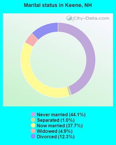
- Never married: 44.1%
- Now married: 37.7%
- Separated: 1.0%
- Widowed: 4.9%
- Divorced: 12.3%
For population 25 years and over in Keene:
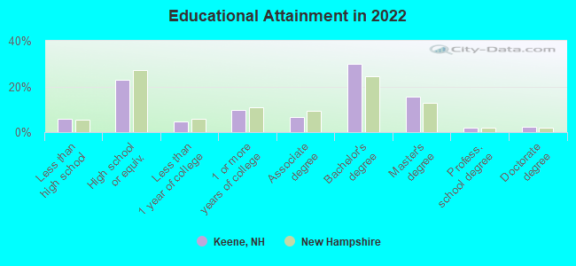
- High school or higher: 93.3%
- Bachelor's degree or higher: 44.1%
- Graduate or professional degree: 15.9%
- Unemployed: 10.8%
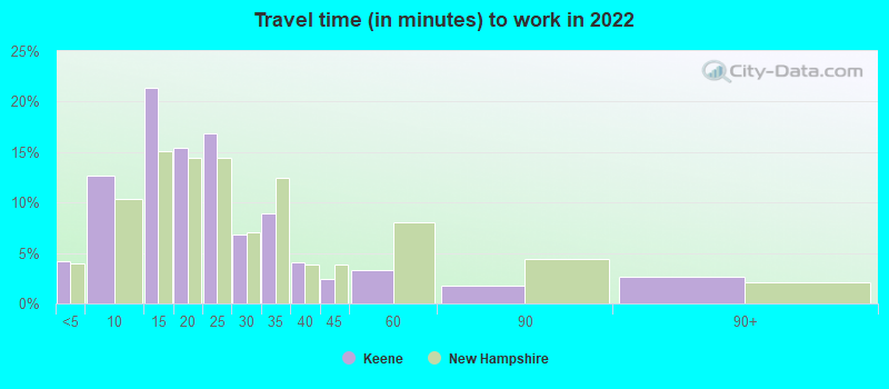
- Mean travel time to work (commute): 14.8 minutes
| Here: | 10.8 |
| New Hampshire average: | 10.3 |

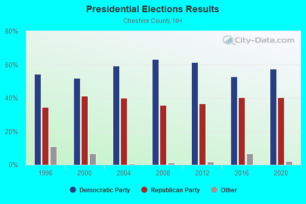
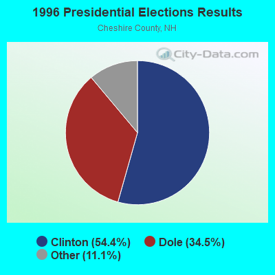
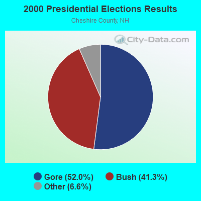
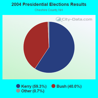

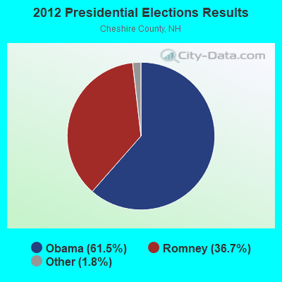
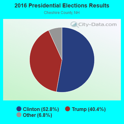
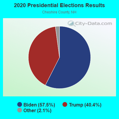
Graphs represent county-level data. Detailed 2008 Election Results
Neighborhoods in Keene:
(Keene, New Hampshire Neighborhood Map)Religion statistics for Keene, NH (based on Cheshire County data)
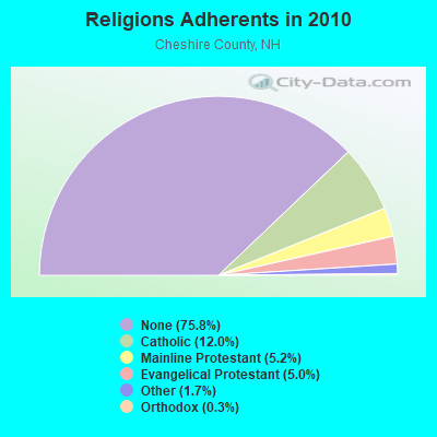
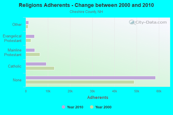
| Religion | Adherents | Congregations |
|---|---|---|
| Catholic | 9,237 | 9 |
| Mainline Protestant | 4,015 | 37 |
| Evangelical Protestant | 3,881 | 25 |
| Other | 1,292 | 13 |
| Orthodox | 250 | 1 |
| None | 58,442 | - |
Food Environment Statistics:
| Cheshire County: | 3.10 / 10,000 pop. |
| New Hampshire: | 2.14 / 10,000 pop. |
| Cheshire County: | 3.10 / 10,000 pop. |
| New Hampshire: | 1.78 / 10,000 pop. |
| Cheshire County: | 3.75 / 10,000 pop. |
| New Hampshire: | 4.02 / 10,000 pop. |
| Cheshire County: | 8.67 / 10,000 pop. |
| State: | 9.70 / 10,000 pop. |
| Cheshire County: | 8.2% |
| State: | 7.6% |
| Cheshire County: | 27.5% |
| New Hampshire: | 24.4% |
| This county: | 14.5% |
| New Hampshire: | 15.9% |
Health and Nutrition:
| Here: | 57.9% |
| New Hampshire: | 51.2% |
| Here: | 60.4% |
| State: | 49.1% |
| Keene: | 27.8 |
| New Hampshire: | 28.5 |
| Keene: | 17.2% |
| New Hampshire: | 20.9% |
| This city: | 8.0% |
| New Hampshire: | 9.3% |
| This city: | 7.0 |
| New Hampshire: | 6.9 |
| This city: | 32.9% |
| New Hampshire: | 34.3% |
| Keene: | 65.0% |
| New Hampshire: | 58.1% |
| This city: | 81.5% |
| State: | 79.1% |
More about Health and Nutrition of Keene, NH Residents
| Local government employment and payroll (March 2022) | |||||
| Function | Full-time employees | Monthly full-time payroll | Average yearly full-time wage | Part-time employees | Monthly part-time payroll |
|---|---|---|---|---|---|
| Firefighters | 45 | $387,265 | $103,271 | 2 | $42 |
| Police Protection - Officers | 40 | $293,951 | $88,185 | 0 | $0 |
| Streets and Highways | 23 | $105,041 | $54,804 | 0 | $0 |
| Financial Administration | 23 | $157,564 | $82,207 | 2 | $3,658 |
| Other and Unallocable | 22 | $131,458 | $71,704 | 9 | $24,410 |
| Sewerage | 12 | $70,742 | $70,742 | 0 | $0 |
| Parks and Recreation | 10 | $52,944 | $63,533 | 17 | $12,475 |
| Water Supply | 10 | $55,056 | $66,067 | 0 | $0 |
| Local Libraries | 8 | $49,751 | $74,627 | 23 | $38,617 |
| Housing and Community Development (Local) | 8 | $49,551 | $74,327 | 1 | $1,808 |
| Police - Other | 8 | $38,462 | $57,693 | 9 | $15,137 |
| Solid Waste Management | 8 | $46,296 | $69,444 | 6 | $11,616 |
| Other Government Administration | 7 | $58,811 | $100,819 | 22 | $33,075 |
| Welfare | 3 | $16,656 | $66,624 | 0 | $0 |
| Airports | 3 | $21,217 | $84,868 | 1 | $1,178 |
| Judicial and Legal | 2 | $17,852 | $107,112 | 0 | $0 |
| Health | 1 | $10,208 | $122,496 | 1 | $1,603 |
| Fire - Other | 1 | $5,514 | $66,168 | 0 | $0 |
| Totals for Government | 234 | $1,568,339 | $80,428 | 93 | $143,619 |
Keene government finances - Expenditure in 2021 (per resident):
- Construction - Water Utilities: $3,454,000 ($151.66)
Regular Highways: $3,374,000 ($148.15)
Sewerage: $1,723,000 ($75.66)
General Public Buildings: $160,000 ($7.03)
Central Staff Services: $135,000 ($5.93)
Air Transportation: $35,000 ($1.54)
Libraries: $11,000 ($0.48)
Parks and Recreation: $8,000 ($0.35)
- Current Operations - Police Protection: $7,531,000 ($330.68)
Local Fire Protection: $7,366,000 ($323.44)
Central Staff Services: $7,293,000 ($320.23)
Regular Highways: $6,236,000 ($273.82)
Solid Waste Management: $5,179,000 ($227.41)
Sewerage: $3,896,000 ($171.07)
Water Utilities: $2,959,000 ($129.93)
General Public Buildings: $1,875,000 ($82.33)
Financial Administration: $1,537,000 ($67.49)
Libraries: $1,442,000 ($63.32)
Parks and Recreation: $1,245,000 ($54.67)
Parking Facilities: $799,000 ($35.08)
Air Transportation: $694,000 ($30.47)
Public Welfare - Other: $499,000 ($21.91)
Miscellaneous Commercial Activities - Other: $414,000 ($18.18)
Judicial and Legal Services: $305,000 ($13.39)
General - Other: $113,000 ($4.96)
Protective Inspection and Regulation - Other: $17,000 ($0.75)
Public Welfare, Vendor Payments for Medical Care: $3,000 ($0.13)
- General - Interest on Debt: $1,051,000 ($46.15)
- Other Capital Outlay - Local Fire Protection: $975,000 ($42.81)
Regular Highways: $887,000 ($38.95)
Air Transportation: $418,000 ($18.35)
Central Staff Services: $265,000 ($11.64)
Police Protection: $226,000 ($9.92)
Water Utilities: $33,000 ($1.45)
Sewerage: $32,000 ($1.41)
Libraries: $20,000 ($0.88)
General Public Building: $11,000 ($0.48)
Parks and Recreation: $6,000 ($0.26)
General - Other: $4,000 ($0.18)
Financial Administration: $3,000 ($0.13)
Miscellaneous Commercial Activities - Other: $2,000 ($0.09)
Public Welfare - Other: $2,000 ($0.09)
Judicial and Legal Services: $1,000 ($0.04)
Solid Waste Management: $1,000 ($0.04)
Parking Facilities: $1,000 ($0.04)
- Total Salaries and Wages: $18,441,000 ($809.74)
Keene government finances - Revenue in 2021 (per resident):
- Charges - Sewerage: $6,196,000 ($272.06)
Solid Waste Management: $5,130,000 ($225.26)
Other: $4,245,000 ($186.40)
Parking Facilities: $571,000 ($25.07)
Air Transportation: $417,000 ($18.31)
Miscellaneous Commercial Activities: $331,000 ($14.53)
Parks and Recreation: $151,000 ($6.63)
- Federal Intergovernmental - Other: $8,000 ($0.35)
- Local Intergovernmental - Other: $1,044,000 ($45.84)
- Miscellaneous - General Revenue - Other: $422,000 ($18.53)
Rents: $346,000 ($15.19)
Interest Earnings: $256,000 ($11.24)
Fines and Forfeits: $246,000 ($10.80)
Donations From Private Sources: $34,000 ($1.49)
- Revenue - Water Utilities: $3,870,000 ($169.93)
- State Intergovernmental - Highways: $2,245,000 ($98.58)
Other: $1,733,000 ($76.10)
General Local Government Support: $1,186,000 ($52.08)
Sewerage: $411,000 ($18.05)
Housing and Community Development: $143,000 ($6.28)
Water Utilities: $20,000 ($0.88)
- Tax - Property: $33,332,000 ($1463.60)
Occupation and Business License - Other: $691,000 ($30.34)
Other License: $13,000 ($0.57)
Keene government finances - Debt in 2021 (per resident):
- Long Term Debt - Beginning Outstanding - Unspecified Public Purpose: $19,533,000 ($857.69)
Outstanding Unspecified Public Purpose: $18,138,000 ($796.43)
Retired Unspecified Public Purpose: $3,712,000 ($162.99)
Issue, Unspecified Public Purpose: $2,318,000 ($101.78)
Keene government finances - Cash and Securities in 2021 (per resident):
- Other Funds - Cash and Securities: $86,733,000 ($3808.42)
| Businesses in Keene, NH | ||||
| Name | Count | Name | Count | |
|---|---|---|---|---|
| 7-Eleven | 1 | McDonald's | 1 | |
| AT&T | 1 | New Balance | 4 | |
| Ace Hardware | 1 | Nike | 9 | |
| Advance Auto Parts | 1 | Olive Garden | 1 | |
| Applebee's | 1 | Panera Bread | 1 | |
| AutoZone | 1 | Payless | 1 | |
| Bed Bath & Beyond | 1 | Penske | 1 | |
| Best Western | 1 | Pier 1 Imports | 1 | |
| Burger King | 1 | Pizza Hut | 1 | |
| CVS | 1 | RadioShack | 1 | |
| Chevrolet | 1 | Rite Aid | 1 | |
| Circle K | 1 | Sears | 1 | |
| Curves | 1 | Shaw's | 1 | |
| DHL | 1 | Staples | 1 | |
| Days Inn | 1 | Starbucks | 2 | |
| Decora Cabinetry | 2 | Subaru | 1 | |
| Domino's Pizza | 1 | Subway | 1 | |
| Dunkin Donuts | 3 | T-Mobile | 1 | |
| Famous Footwear | 1 | T.J.Maxx | 1 | |
| Fashion Bug | 1 | Taco Bell | 1 | |
| FedEx | 3 | Target | 1 | |
| GNC | 1 | The Room Place | 1 | |
| GameStop | 2 | True Value | 1 | |
| H&R Block | 2 | U-Haul | 2 | |
| Holiday Inn | 1 | U.S. Cellular | 1 | |
| Home Depot | 1 | UPS | 9 | |
| Hyundai | 1 | Vans | 2 | |
| JCPenney | 1 | Verizon Wireless | 1 | |
| Jones New York | 2 | Volkswagen | 1 | |
| KFC | 1 | Walgreens | 1 | |
| Marriott | 1 | Walmart | 1 | |
| MasterBrand Cabinets | 4 | Wendy's | 1 | |
| Maurices | 1 | YMCA | 1 | |
Strongest AM radio stations in Keene:
- WKBK (1290 AM; 5 kW; KEENE, NH; Owner: SAGA COMMUNICATIONS OF NEW ENGLAND, LLC)
- WZBK (1220 AM; 1 kW; KEENE, NH; Owner: SAGA COMMUNICATIONS OF NEW HAMPSHIRE, LLC)
- WCRN (830 AM; 50 kW; WORCESTER, MA; Owner: CARTER BROADCASTING CORPORATION)
- WNNZ (640 AM; 50 kW; WESTFIELD, MA; Owner: CLEAR CHANNEL BROADCASTING LICENSES, INC.)
- WRKO (680 AM; 50 kW; BOSTON, MA; Owner: ENTERCOM BOSTON LICENSE, LLC)
- WVNE (760 AM; daytime; 25 kW; LEICESTER, MA; Owner: BLOUNT MASSCOM, INC.)
- WEEI (850 AM; 50 kW; BOSTON, MA; Owner: ENTERCOM BOSTON LICENSE, LLC)
- WNTK (1020 AM; 10 kW; NEWPORT, NH; Owner: KOOR COMMUNICATIONS, INC.)
- WKOX (1200 AM; 50 kW; FRAMINGHAM, MA; Owner: CAPSTAR TX LIMITED PARTNERSHIP)
- WBIX (1060 AM; 40 kW; NATICK, MA; Owner: LANGER BROADCASTING CORPORATION)
- WALE (990 AM; 50 kW; GREENVILLE, RI; Owner: NORTH AMERICAN BROADCASTING CO., INC.)
- WIZZ (1520 AM; daytime; 10 kW; GREENFIELD, MA; Owner: P. & M. RADIO, LLC)
- WGY (810 AM; 50 kW; SCHENECTADY, NY; Owner: CLEAR CHANNEL BROADCASTING LICENSES, INC.)
Strongest FM radio stations in Keene:
- W293AB (106.5 FM; KEENE, NH; Owner: GREAT NORTHERN RADIO, L.L.C.)
- WKNE (103.7 FM; KEENE, NH; Owner: SAGA COMMUNICATIONS OF NEW ENGLAND, LLC)
- WEVN (90.7 FM; KEENE, NH; Owner: NEW HAMPSHIRE PUBLIC RADIO, INC.)
- WOQL (98.7 FM; WINCHESTER, NH; Owner: SAGA COMMUNICATIONS OF NEW HAMPSHIRE, LLC)
- WFEX (92.1 FM; PETERBOROUGH, NH; Owner: FNX BROADCASTING OF NEW HAMPSHIRE LLC)
- WHDQ (106.1 FM; CLAREMONT, NH; Owner: GREAT NORTHERN RADIO, L.L.C.)
- WKNH (91.3 FM; KEENE, NH; Owner: KEENE STATE COLLEGE)
- WYRY (104.9 FM; HINSDALE, NH; Owner: TRI-VALLEY BROADCASTING CORPORATION)
- WCMK (91.9 FM; PUTNEY, VT; Owner: CHRISTIAN MINISTRIES INC)
- WVPR (89.5 FM; WINDSOR, VT; Owner: VERMONT PUBLIC RADIO)
- WEQX (102.7 FM; MANCHESTER, VT; Owner: NORTHSHIRE COMMUNICATIONS, INC.)
- WJAN (95.1 FM; SUNDERLAND, VT; Owner: 6 JOHNSON ROAD LICENSES, INC.)
- WVAY (100.7 FM; WILMINGTON, VT; Owner: GREAT NORTHERN RADIO, L.L.C.)
- WJJR (98.1 FM; RUTLAND, VT; Owner: 6 JOHNSON ROAD LICENSES, INC.)
- WZRT (97.1 FM; RUTLAND, VT; Owner: CAPSTAR TX LIMITED PARTNERSHIP)
- WRSY (101.5 FM; MARLBORO, VT; Owner: GREAT NORTHERN RADIO, L.L.C.)
- WTPL (107.7 FM; HILLSBORO, NH; Owner: CONCORD BROADCASTING, L.L.C.)
- WEBK (105.3 FM; KILLINGTON, VT; Owner: 6 JOHNSON ROAD LICENSES, INC.)
- WKVT-FM (92.7 FM; BRATTLEBORO, VT; Owner: SAGA COMMUNICATIONS OF NEW ENGLAND, LLC)
- WPVQ (95.3 FM; GREENFIELD, MA; Owner: GREAT NORTHERN RADIO, L.L.C.)
TV broadcast stations around Keene:
- WEKW-TV (Channel 52; KEENE, NH; Owner: UNIVERSITY OF NEW HAMPSHIRE)
- WUNI (Channel 27; WORCESTER, MA; Owner: ENTRAVISION HOLDINGS, LLC)
Medal of Honor Recipients
Medal of Honor Recipient born in Keene: Charles H. Knight.
- National Bridge Inventory (NBI) Statistics
- 32Number of bridges
- 240ft / 73.3mTotal length
- $84,940,000Total costs
- 233,325Total average daily traffic
- 12,131Total average daily truck traffic
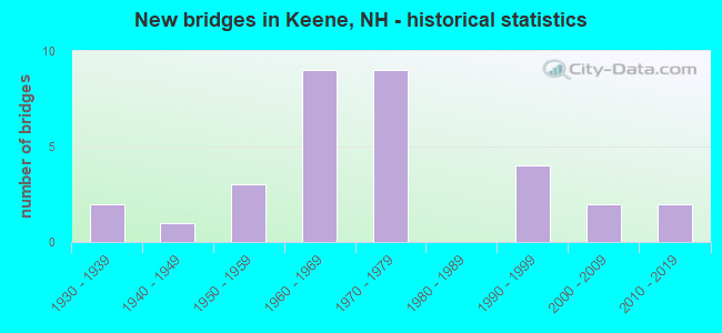
- New bridges - historical statistics
- 21930-1939
- 11940-1949
- 31950-1959
- 91960-1969
- 91970-1979
- 41990-1999
- 22000-2009
- 22010-2019
FCC Registered Antenna Towers: 99 (See the full list of FCC Registered Antenna Towers)
FCC Registered Commercial Land Mobile Towers: 3 (See the full list of FCC Registered Commercial Land Mobile Towers in Keene, NH)
FCC Registered Private Land Mobile Towers: 1 (See the full list of FCC Registered Private Land Mobile Towers)
FCC Registered Broadcast Land Mobile Towers: 26 (See the full list of FCC Registered Broadcast Land Mobile Towers)
FCC Registered Microwave Towers: 34 (See the full list of FCC Registered Microwave Towers in this town)
FCC Registered Paging Towers: 3 (See the full list of FCC Registered Paging Towers)
FCC Registered Maritime Coast & Aviation Ground Towers: 2 (See the full list of FCC Registered Maritime Coast & Aviation Ground Towers)
FCC Registered Amateur Radio Licenses: 121 (See the full list of FCC Registered Amateur Radio Licenses in Keene)
FAA Registered Aircraft Manufacturers and Dealers: 1 (See the full list of FAA Registered Manufacturers and Dealers in Keene)
FAA Registered Aircraft: 28 (See the full list of FAA Registered Aircraft)
2002 - 2018 National Fire Incident Reporting System (NFIRS) incidents
- Fire incident types reported to NFIRS in Keene, NH
- 1,13659.3%Structure Fires
- 45223.6%Outside Fires
- 1909.9%Mobile Property/Vehicle Fires
- 1387.2%Other
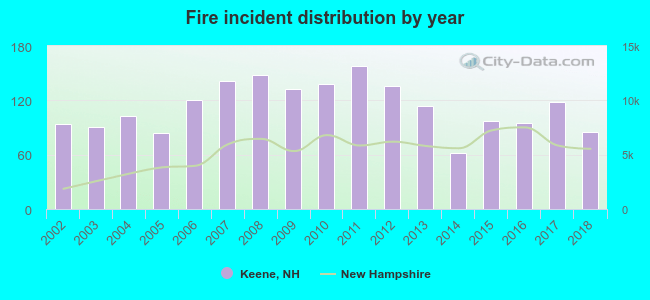 Based on the data from the years 2002 - 2018 the average number of fires per year is 113. The highest number of fire incidents - 158 took place in 2011, and the least - 62 in 2014. The data has a declining trend.
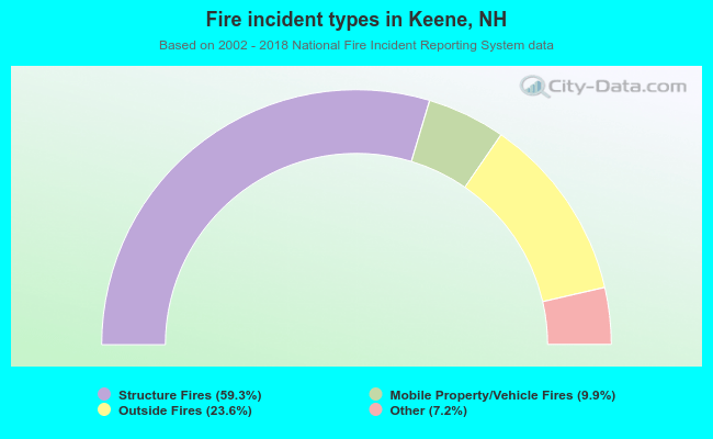 When looking into fire subcategories, the most reports belonged to: Structure Fires (59.3%), and Outside Fires (23.6%).
Fire-safe hotels and motels in Keene, New Hampshire:
- Holiday Inn Express-Keene, 175 Key Rd, Keene, New Hampshire 03431 , Phone: (603) 352-7616, Fax: (603) 357-3619
- Lane Hotel, The, 30 Main St, Keene, New Hampshire 03431 , Phone: (603) 357-7070, Fax: (603) 357-7075
- Best Western Sovereign Hotel, 401 Winchester St, Keene, New Hampshire 03431 , Phone: (603) 357-3038, Fax: (603) 357-4776
- Courtyard By Marriott, 75 Railroad St, Keene, New Hampshire 03431 , Phone: (603) 354-7900, Fax: (603) 354-7901
| Most common first names in Keene, NH among deceased individuals | ||
| Name | Count | Lived (average) |
|---|---|---|
| Mary | 386 | 80.8 years |
| John | 340 | 75.6 years |
| Robert | 326 | 72.8 years |
| William | 292 | 75.4 years |
| Helen | 226 | 81.8 years |
| George | 222 | 78.1 years |
| Edward | 214 | 75.4 years |
| James | 206 | 73.7 years |
| Charles | 202 | 76.6 years |
| Ruth | 196 | 81.6 years |
| Most common last names in Keene, NH among deceased individuals | ||
| Last name | Count | Lived (average) |
|---|---|---|
| Smith | 128 | 78.5 years |
| Davis | 96 | 76.1 years |
| White | 86 | 81.5 years |
| Johnson | 84 | 79.3 years |
| Bergeron | 68 | 77.7 years |
| Brown | 64 | 74.3 years |
| Wilson | 62 | 77.4 years |
| Croteau | 60 | 73.8 years |
| Miller | 60 | 79.8 years |
| Clark | 58 | 79.7 years |
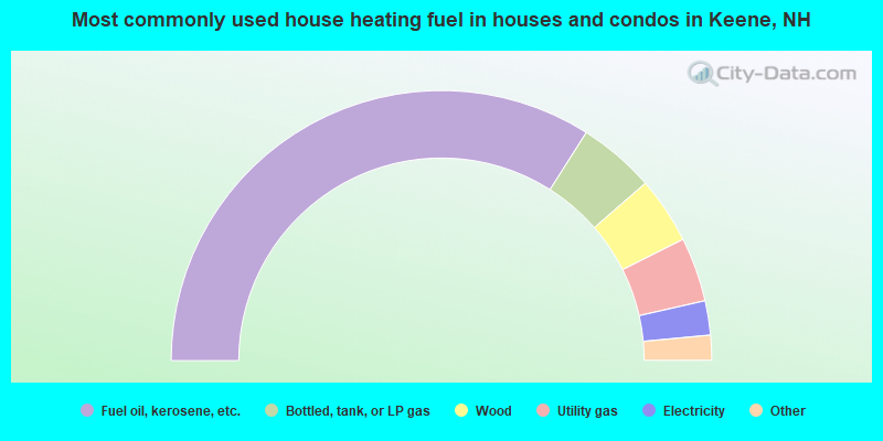
- 68.0%Fuel oil, kerosene, etc.
- 9.2%Bottled, tank, or LP gas
- 8.0%Wood
- 7.7%Utility gas
- 4.1%Electricity
- 2.6%Other fuel
- 0.2%Solar energy
- 0.2%No fuel used
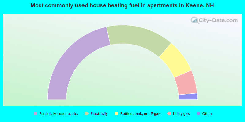
- 43.2%Fuel oil, kerosene, etc.
- 29.4%Electricity
- 14.6%Bottled, tank, or LP gas
- 10.1%Utility gas
- 1.6%Solar energy
- 0.8%No fuel used
- 0.3%Other fuel
Keene compared to New Hampshire state average:
- Median house value below state average.
- Hispanic race population percentage below state average.
- Median age significantly below state average.
- Renting percentage above state average.
- House age above state average.
- Number of college students above state average.
Keene on our top lists:
- #37 on the list of "Top 101 cities with largest percentage of males in industries: wholesale trade (population 5,000+)"
- #4 on the list of "Top 101 counties with the highest percentage of residents that smoked 100+ cigarettes in their lives"
- #7 on the list of "Top 101 counties with the highest Sulfur Oxides Annual air pollution readings in 2012 (µg/m3)"
- #26 on the list of "Top 101 counties with the lowest Ozone (1-hour) air pollution readings in 2012 (ppm)"
- #47 on the list of "Top 101 counties with the lowest average weight of females"
- #65 on the list of "Top 101 counties with the best general health status score of residents (1-5), 3 years of data"

|
|
Total of 109 patent applications in 2008-2024.