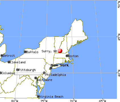
Surry, New Hampshire
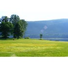
Submit your own pictures of this town and show them to the world
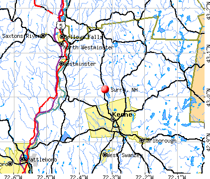
- OSM Map
- General Map
- Google Map
- MSN Map
Population change since 2000: +8.8%
 |
| Males: 364 | |
| Females: 368 |
| Median resident age: | 48.4 years |
| New Hampshire median age: | 43.9 years |
Zip codes: 03431.
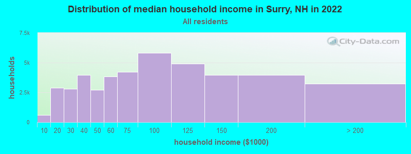
| Surry: | $104,510 |
| NH: | $89,992 |
Estimated per capita income in 2022: $48,846 (it was $24,277 in 2000)
Surry town income, earnings, and wages data
Estimated median house or condo value in 2022: $333,951 (it was $128,900 in 2000)
| Surry: | $333,951 |
| NH: | $384,700 |
Mean prices in 2022: all housing units: $286,446; detached houses: $308,243; townhouses or other attached units: $255,194; in 2-unit structures: $255,554; in 3-to-4-unit structures: $346,438; in 5-or-more-unit structures: $233,006; mobile homes: $69,259
Detailed information about poverty and poor residents in Surry, NH


- 71497.5%White alone
- 91.2%Asian alone
- 40.5%Two or more races
- 40.5%Hispanic
- 10.1%Black alone
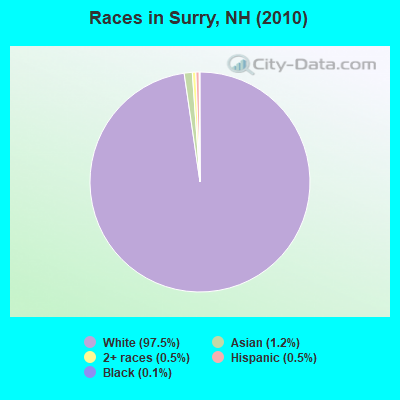
Races in Surry detailed stats: ancestries, foreign born residents, place of birth
According to our research of New Hampshire and other state lists, there were 4 registered sex offenders living in Surry, New Hampshire as of May 17, 2024.
The ratio of all residents to sex offenders in Surry is 183 to 1.
 Recent articles from our blog. Our writers, many of them Ph.D. graduates or candidates, create easy-to-read articles on a wide variety of topics.

 | Looking at Southern NH...Where would you recommend searching? (15 replies) |
| Where in NH? (22 replies) |
| moving from OK to NH and looking to homestead (6 replies) |
| LA to New England-Looking at New Hampshire (47 replies) |
| Worst places in N.H. (362 replies) |
| Looking for mining/rockhounding spots in NH (4 replies) |
Latest news from Surry, NH collected exclusively by city-data.com from local newspapers, TV, and radio stations
Ancestries: English (25.4%), German (15.2%), French (13.8%), Irish (13.5%), Scottish (10.5%), French Canadian (8.6%).
Current Local Time: EST time zone
Incorporated in 1769
Elevation: 545 feet
Land area: 15.6 square miles.
Population density: 47 people per square mile (very low).
13 residents are foreign born
| This town: | 1.9% |
| New Hampshire: | 4.4% |
| Surry town: | 1.8% ($2,290) |
| New Hampshire: | 2.3% ($2,946) |
Nearest city with pop. 50,000+: Manchester, NH  (44.8 miles , pop. 107,006).
Nearest city with pop. 200,000+: Boston, MA (79.5 miles , pop. 589,141).
Nearest city with pop. 1,000,000+: Bronx, NY (169.4 miles , pop. 1,332,650).
Nearest cities:
), ), ), )Latitude: 43.01 N, Longitude: 72.34 W
Area code commonly used in this area: 603

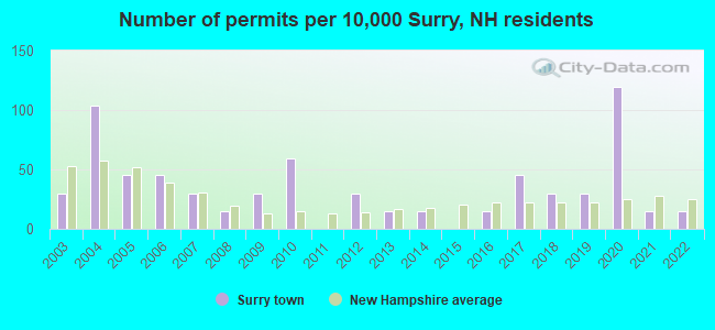
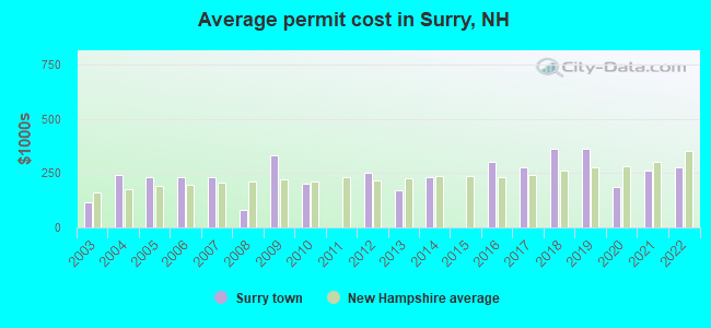
Single-family new house construction building permits:
- 2022: 1 building, cost: $279,200
- 2021: 1 building, cost: $259,200
- 2020: 8 buildings, average cost: $185,700
- 2019: 2 buildings, average cost: $362,500
- 2018: 2 buildings, average cost: $362,500
- 2017: 3 buildings, average cost: $276,700
- 2016: 1 building, cost: $300,000
- 2014: 1 building, cost: $230,000
- 2013: 1 building, cost: $170,000
- 2012: 2 buildings, average cost: $250,000
- 2010: 4 buildings, average cost: $200,000
- 2009: 2 buildings, average cost: $330,000
- 2008: 1 building, cost: $80,000
- 2007: 2 buildings, average cost: $233,300
- 2006: 3 buildings, average cost: $233,300
- 2005: 3 buildings, average cost: $233,300
- 2004: 7 buildings, average cost: $239,300
- 2003: 2 buildings, average cost: $115,000
| Here: | 1.5% |
| New Hampshire: | 2.5% |
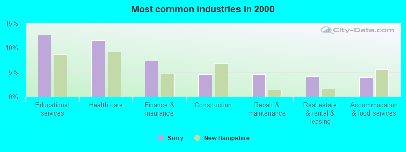
- Educational services (12.6%)
- Health care (11.6%)
- Finance & insurance (7.3%)
- Construction (4.5%)
- Repair & maintenance (4.5%)
- Real estate & rental & leasing (4.3%)
- Accommodation & food services (4.0%)
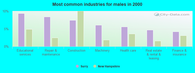
- Educational services (9.3%)
- Repair & maintenance (8.4%)
- Construction (7.5%)
- Machinery (6.1%)
- Health care (5.6%)
- Real estate & rental & leasing (4.7%)
- Finance & insurance (4.2%)
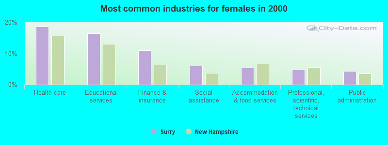
- Health care (18.7%)
- Educational services (16.5%)
- Finance & insurance (11.0%)
- Social assistance (6.0%)
- Accommodation & food services (5.5%)
- Professional, scientific, technical services (4.9%)
- Public administration (4.4%)
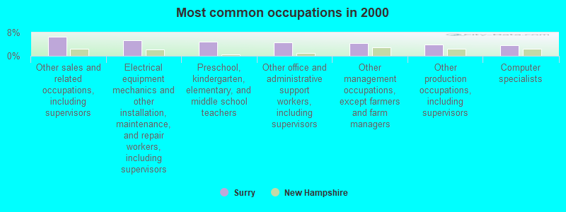
- Other sales and related occupations, including supervisors (6.6%)
- Electrical equipment mechanics and other installation, maintenance, and repair workers, including supervisors (5.3%)
- Preschool, kindergarten, elementary, and middle school teachers (4.8%)
- Other office and administrative support workers, including supervisors (4.5%)
- Other management occupations, except farmers and farm managers (4.3%)
- Other production occupations, including supervisors (3.8%)
- Computer specialists (3.5%)
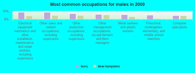
- Electrical equipment mechanics and other installation, maintenance, and repair workers, including supervisors (8.9%)
- Other sales and related occupations, including supervisors (8.9%)
- Other production occupations, including supervisors (7.0%)
- Other management occupations, except farmers and farm managers (6.1%)
- Metal workers and plastic workers (5.6%)
- Preschool, kindergarten, elementary, and middle school teachers (5.1%)
- Computer specialists (4.7%)
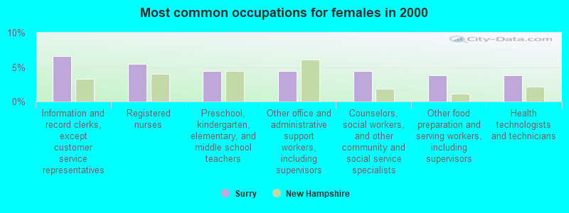
- Information and record clerks, except customer service representatives (6.6%)
- Registered nurses (5.5%)
- Preschool, kindergarten, elementary, and middle school teachers (4.4%)
- Other office and administrative support workers, including supervisors (4.4%)
- Counselors, social workers, and other community and social service specialists (4.4%)
- Other food preparation and serving workers, including supervisors (3.8%)
- Health technologists and technicians (3.8%)
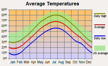
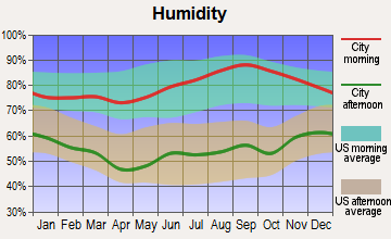
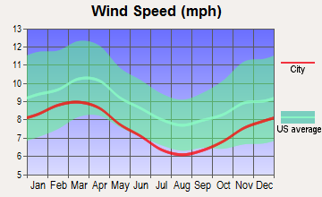
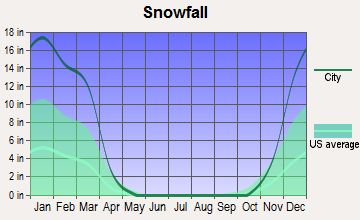
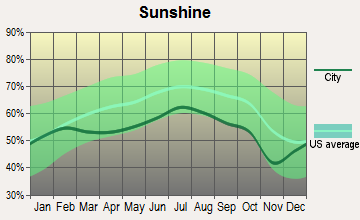
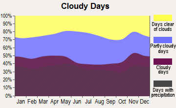
Average climate in Surry, New Hampshire
Based on data reported by over 4,000 weather stations
(lower is better)
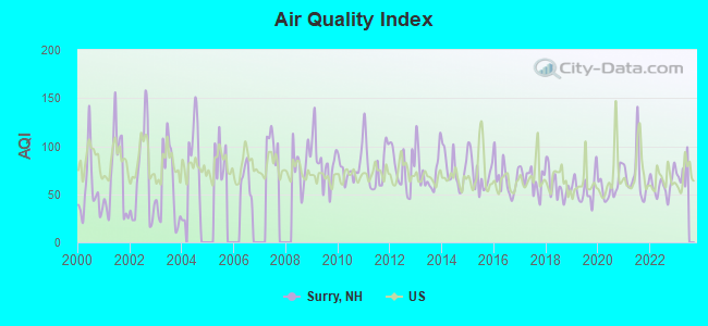
Air Quality Index (AQI) level in 2022 was 59.0. This is better than average.
| City: | 59.0 |
| U.S.: | 72.6 |
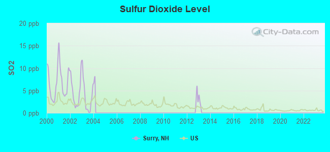
Sulfur Dioxide (SO2) [ppb] level in 2003 was 3.66. This is significantly worse than average. Closest monitor was 6.1 miles away from the city center.
| City: | 3.66 |
| U.S.: | 1.51 |
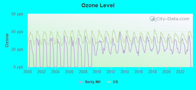
Ozone [ppb] level in 2022 was 23.7. This is significantly better than average. Closest monitor was 6.1 miles away from the city center.
| City: | 23.7 |
| U.S.: | 33.3 |
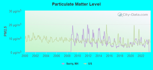
Particulate Matter (PM2.5) [µg/m3] level in 2022 was 5.97. This is better than average. Closest monitor was 6.6 miles away from the city center.
| City: | 5.97 |
| U.S.: | 8.11 |
Tornado activity:
Surry-area historical tornado activity is above New Hampshire state average. It is 31% smaller than the overall U.S. average.
On 6/9/1953, a category F4 (max. wind speeds 207-260 mph) tornado 38.5 miles away from the Surry town center killed 90 people and injured 1228 people and caused between $50,000,000 and $500,000,000 in damages.
On 8/20/1968, a category F3 (max. wind speeds 158-206 mph) tornado 24.2 miles away from the town center injured one person and caused between $5000 and $50,000 in damages.
Earthquake activity:
Surry-area historical earthquake activity is significantly above New Hampshire state average. It is 70% smaller than the overall U.S. average.On 10/7/1983 at 10:18:46, a magnitude 5.3 (5.1 MB, 5.3 LG, 5.1 ML, Class: Moderate, Intensity: VI - VII) earthquake occurred 119.8 miles away from the city center
On 4/20/2002 at 10:50:47, a magnitude 5.3 (5.3 ML, Depth: 3.0 mi) earthquake occurred 124.0 miles away from the city center
On 4/20/2002 at 10:50:47, a magnitude 5.2 (5.2 MB, 4.2 MS, 5.2 MW, 5.0 MW) earthquake occurred 123.1 miles away from the city center
On 1/19/1982 at 00:14:42, a magnitude 4.7 (4.5 MB, 4.7 MD, 4.5 LG, Class: Light, Intensity: IV - V) earthquake occurred 50.2 miles away from the city center
On 10/16/2012 at 23:12:25, a magnitude 4.7 (4.7 ML, Depth: 10.0 mi) earthquake occurred 93.8 miles away from Surry center
On 6/17/1991 at 08:53:16, a magnitude 4.1 (4.0 MB, 4.0 LG, Depth: 3.1 mi) earthquake occurred 121.7 miles away from the city center
Magnitude types: regional Lg-wave magnitude (LG), body-wave magnitude (MB), duration magnitude (MD), local magnitude (ML), surface-wave magnitude (MS), moment magnitude (MW)
Natural disasters:
The number of natural disasters in Cheshire County (27) is a lot greater than the US average (15).Major Disasters (Presidential) Declared: 16
Emergencies Declared: 11
Causes of natural disasters: Floods: 11, Storms: 11, Snows: 4, Snowstorms: 3, Winter Storms: 3, Hurricanes: 2, Blizzard: 1, Heavy Rain: 1, Ice Storm: 1, Landslide: 1, Snowfall: 1, Tropical Storm: 1, Wind: 1, Other: 1 (Note: some incidents may be assigned to more than one category).
Hospitals and medical centers near Surry:
- CEDARCREST INC (Hospital, about 5 miles away; KEENE, NH)
- KEENE CENTER, GENESIS HEALTHCARE (Nursing Home, about 5 miles away; KEENE, NH)
- CHESHIRE MEDICAL CENTER Acute Care Hospitals (about 5 miles away; KEENE, NH)
- SNF CHESHIRE MEDICAL CTR. (Nursing Home, about 5 miles away; KEENE, NH)
- HOSPICE OF THE MONADNOCK REGION (Hospital, about 7 miles away; KEENE, NH)
- WESTWOOD CARE AND REHABILITATION CENTER (Nursing Home, about 7 miles away; KEENE, NH)
- CHESHIRE COUNTY HOME (Nursing Home, about 8 miles away; WESTMORELAND, NH)
Amtrak stations near Surry:
- 11 miles: BELLOWS FALLS (DEPOT ST.) . Services: enclosed waiting area, public restrooms, public payphones, free short-term parking, free long-term parking, call for taxi service.
- 17 miles: BRATTLEBORO (VERNON RD.) . Services: enclosed waiting area, public restrooms, call for car rental service, call for taxi service.
Operable nuclear power plant near Surry:
- 20 miles: Vermont Yankee in Vernon, VT.
Colleges/universities with over 2000 students nearest to Surry:
- Keene State College (about 7 miles; Keene, NH; Full-time enrollment: 5,098)
- Franklin Pierce University (about 22 miles; Rindge, NH; FT enrollment: 2,139)
- Mount Wachusett Community College (about 35 miles; Gardner, MA; FT enrollment: 3,143)
- Fitchburg State University (about 41 miles; Fitchburg, MA; FT enrollment: 5,010)
- Saint Anselm College (about 42 miles; Manchester, NH; FT enrollment: 2,059)
- NHTI-Concord's Community College (about 44 miles; Concord, NH; FT enrollment: 2,865)
- Mount Washington College (about 44 miles; Manchester, NH; FT enrollment: 2,187)
Public elementary/middle school in Surry:
- SURRY VILLAGE CHARTER SCHOOL (Students: 28, Location: 449 ROUTE 12A, Grades: KG-8, Charter school)
Points of interest:
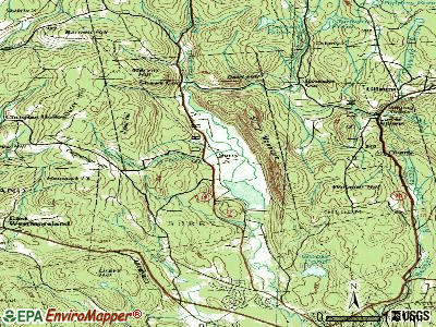
Notable locations in Surry: Surry Mountain Camping Area (A), Surry Volunteer Fire Department (B). Display/hide their locations on the map
Church in Surry: Beth-el Bible Church (A). Display/hide its location on the map
Lakes and reservoirs: Lily Pond (A), Rodgers Pond (B), Surry Mountain Lake (C). Display/hide their locations on the map
Streams, rivers, and creeks: Thompson Brook (A), Merriam Brook (B), Cannon Brook (C). Display/hide their locations on the map
Drinking water stations with addresses in Surry that have no violations reported:
- SURRY MOUNTAIN CAMPING AREA (Population served: 138, Primary Water Source Type: Groundwater)
| This town: | 2.4 people |
| New Hampshire: | 2.5 people |
| This town: | 72.9% |
| Whole state: | 66.3% |
| This town: | 6.5% |
| Whole state: | 8.3% |
Likely homosexual households (counted as self-reported same-sex unmarried-partner households)
- Lesbian couples: 1.3% of all households
- Gay men: 1.0% of all households
| This town: | 1.8% |
| Whole state: | 6.5% |
| This town: | 0.4% |
| Whole state: | 2.8% |
For population 15 years and over in Surry:
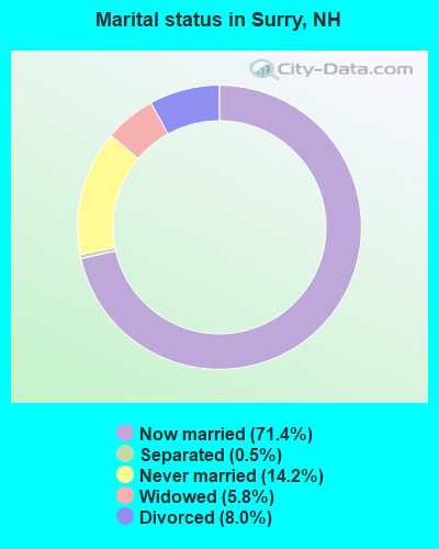
- Never married: 14.2%
- Now married: 71.4%
- Separated: 0.5%
- Widowed: 5.8%
- Divorced: 8.0%
For population 25 years and over in Surry:
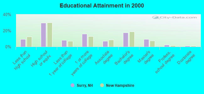
- High school or higher: 90.6%
- Bachelor's degree or higher: 30.2%
- Graduate or professional degree: 12.8%
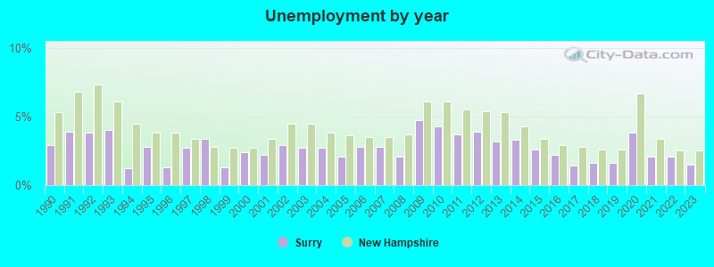
- Unemployed: 1.0%
- Mean travel time to work (commute): 19.8 minutes
| Here: | 10.9 |
| New Hampshire average: | 10.9 |
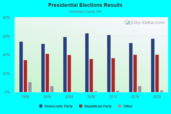
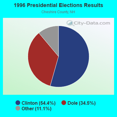
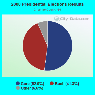
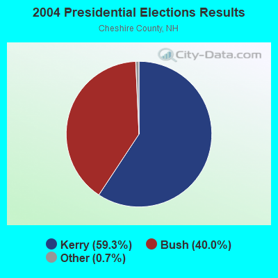

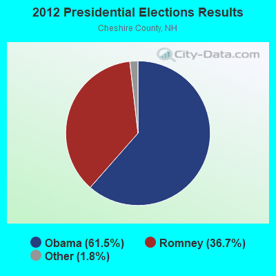
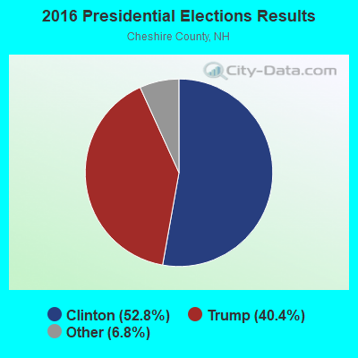
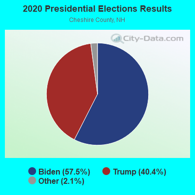
Graphs represent county-level data. Detailed 2008 Election Results
Religion statistics for Surry, NH (based on Cheshire County data)
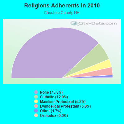
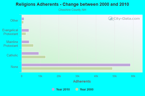
| Religion | Adherents | Congregations |
|---|---|---|
| Catholic | 9,237 | 9 |
| Mainline Protestant | 4,015 | 37 |
| Evangelical Protestant | 3,881 | 25 |
| Other | 1,292 | 13 |
| Orthodox | 250 | 1 |
| None | 58,442 | - |
Food Environment Statistics:
| Cheshire County: | 3.10 / 10,000 pop. |
| New Hampshire: | 2.14 / 10,000 pop. |
| Cheshire County: | 3.10 / 10,000 pop. |
| New Hampshire: | 1.78 / 10,000 pop. |
| This county: | 3.75 / 10,000 pop. |
| State: | 4.02 / 10,000 pop. |
| Cheshire County: | 8.67 / 10,000 pop. |
| New Hampshire: | 9.70 / 10,000 pop. |
| Cheshire County: | 8.2% |
| State: | 7.6% |
| Cheshire County: | 27.5% |
| New Hampshire: | 24.4% |
| This county: | 14.5% |
| New Hampshire: | 15.9% |
Strongest AM radio stations in Surry:
- WKBK (1290 AM; 5 kW; KEENE, NH; Owner: SAGA COMMUNICATIONS OF NEW ENGLAND, LLC)
- WZBK (1220 AM; 1 kW; KEENE, NH; Owner: SAGA COMMUNICATIONS OF NEW HAMPSHIRE, LLC)
- WNNZ (640 AM; 50 kW; WESTFIELD, MA; Owner: CLEAR CHANNEL BROADCASTING LICENSES, INC.)
- WCRN (830 AM; 50 kW; WORCESTER, MA; Owner: CARTER BROADCASTING CORPORATION)
- WRKO (680 AM; 50 kW; BOSTON, MA; Owner: ENTERCOM BOSTON LICENSE, LLC)
- WNTK (1020 AM; 10 kW; NEWPORT, NH; Owner: KOOR COMMUNICATIONS, INC.)
- WVNE (760 AM; daytime; 25 kW; LEICESTER, MA; Owner: BLOUNT MASSCOM, INC.)
- WEEI (850 AM; 50 kW; BOSTON, MA; Owner: ENTERCOM BOSTON LICENSE, LLC)
- WKOX (1200 AM; 50 kW; FRAMINGHAM, MA; Owner: CAPSTAR TX LIMITED PARTNERSHIP)
- WNBX (1480 AM; 5 kW; SPRINGFIELD, VT)
- WBIX (1060 AM; 40 kW; NATICK, MA; Owner: LANGER BROADCASTING CORPORATION)
- WGY (810 AM; 50 kW; SCHENECTADY, NY; Owner: CLEAR CHANNEL BROADCASTING LICENSES, INC.)
- WALE (990 AM; 50 kW; GREENVILLE, RI; Owner: NORTH AMERICAN BROADCASTING CO., INC.)
Strongest FM radio stations in Surry:
- WKNE (103.7 FM; KEENE, NH; Owner: SAGA COMMUNICATIONS OF NEW ENGLAND, LLC)
- WEVN (90.7 FM; KEENE, NH; Owner: NEW HAMPSHIRE PUBLIC RADIO, INC.)
- W293AB (106.5 FM; KEENE, NH; Owner: GREAT NORTHERN RADIO, L.L.C.)
- WHDQ (106.1 FM; CLAREMONT, NH; Owner: GREAT NORTHERN RADIO, L.L.C.)
- WVPR (89.5 FM; WINDSOR, VT; Owner: VERMONT PUBLIC RADIO)
- WCMK (91.9 FM; PUTNEY, VT; Owner: CHRISTIAN MINISTRIES INC)
- WOQL (98.7 FM; WINCHESTER, NH; Owner: SAGA COMMUNICATIONS OF NEW HAMPSHIRE, LLC)
- WFEX (92.1 FM; PETERBOROUGH, NH; Owner: FNX BROADCASTING OF NEW HAMPSHIRE LLC)
- WEQX (102.7 FM; MANCHESTER, VT; Owner: NORTHSHIRE COMMUNICATIONS, INC.)
- WJAN (95.1 FM; SUNDERLAND, VT; Owner: 6 JOHNSON ROAD LICENSES, INC.)
- WZSH (107.1 FM; BELLOWS FALLS, VT; Owner: GREAT NORTHERN RADIO, L.L.C.)
- WVAY (100.7 FM; WILMINGTON, VT; Owner: GREAT NORTHERN RADIO, L.L.C.)
- WCFR-FM (96.3 FM; WALPOLE, NH; Owner: GREAT NORTHERN RADIO, LLC)
- WJJR (98.1 FM; RUTLAND, VT; Owner: 6 JOHNSON ROAD LICENSES, INC.)
- WZRT (97.1 FM; RUTLAND, VT; Owner: CAPSTAR TX LIMITED PARTNERSHIP)
- WYRY (104.9 FM; HINSDALE, NH; Owner: TRI-VALLEY BROADCASTING CORPORATION)
- WVRR (101.7 FM; NEWPORT, NH; Owner: CAPSTAR TX LIMITED PARTNERSHIP)
- WEBK (105.3 FM; KILLINGTON, VT; Owner: 6 JOHNSON ROAD LICENSES, INC.)
- WRSY (101.5 FM; MARLBORO, VT; Owner: GREAT NORTHERN RADIO, L.L.C.)
- WKVT-FM (92.7 FM; BRATTLEBORO, VT; Owner: SAGA COMMUNICATIONS OF NEW ENGLAND, LLC)
TV broadcast stations around Surry:
- WEKW-TV (Channel 52; KEENE, NH; Owner: UNIVERSITY OF NEW HAMPSHIRE)
- Surry, New Hampshire
- Fatal accident count8
- Vehicles involved in fatal accidents13
- Fatal accidents involving drunk persons:3
- Fatalities9
- Persons involved in fatal accidents21
- Pedestrians involved in fatal accidents0
- New Hampshire average
- Fatal accident count1010
- Vehicles involved in fatal accidents1513
- Fatal accidents involving drunk persons325
- Fatalities1099
- Persons involved in fatal accidents2315
- Pedestrians involved in fatal accidents117
- National Bridge Inventory (NBI) Statistics
- 3Number of bridges
- 16ft / 5.2mTotal length
- $9,426,000Total costs
- 8,404Total average daily traffic
- 571Total average daily truck traffic
- 12,436Total future (year 2042) average daily traffic
FCC Registered Microwave Towers:
1- Various Locations (Lat: 43.033667 Lon: -72.318417), Overall height: 6.1 m, Call Sign: WNTY217,
Assigned Frequencies: 956.256 MHz, Grant Date: 03/25/2020, Expiration Date: 05/08/2030, Registrant: Keller And Heckman LLP, 1001 G Street Nw, Suite 500 West, Washington, DC 20001, Phone: (202) 434-4100, Fax: (202) 434-4646, Email:
FCC Registered Amateur Radio Licenses:
7- Call Sign: KA1FZL, Licensee ID: L00448445, Grant Date: 03/26/1997, Expiration Date: 03/26/2007, Cancellation Date: 03/20/2002, Registrant: David L Lawrence, 311 Pond Rd, Surry, NH 03431-8119
- Call Sign: KA1HZF, Licensee ID: L00245556, Grant Date: 10/29/2010, Expiration Date: 10/29/2020, Cancellation Date: 11/01/2022, Registrant: George E Davis, 95 Pond Rd, Surry, NH 03431
- Call Sign: KA1QFA, Licensee ID: L01456047, Grant Date: 03/19/2019, Expiration Date: 04/27/2029, Registrant: Becky J W Huntley, 151 Joslin Rd, Surry, NH 03431
- Call Sign: KA1VGM, Licensee ID: L00154017, Grant Date: 04/21/2020, Expiration Date: 03/06/2030, Registrant: Larry A Levesque, 134 Farm Road, Surry, NH 03431
- Call Sign: KC1QP, Grant Date: 10/10/1989, Expiration Date: 10/10/1999, Cancellation Date: 10/11/2001, Registrant: Knud E M Keller, Rt 12a, Surry, NH 03431
- Call Sign: W1EFK, Previous Call Sign: KA1FZL, Licensee ID: L00448445, Grant Date: 02/23/2022, Expiration Date: 03/20/2032, Certifier: David L Lawrence, Registrant: David L Lawrence, 311 Pond Rd, Surry, NH 03431-8119
- Call Sign: KB1QPC, Licensee ID: L01407436, Grant Date: 04/19/2018, Expiration Date: 06/11/2028, Certifier: Tyler J Huntley, Registrant: Tyler J Huntley, 151 Joslin Rd, Surry, NH 03431

- 64.1%Fuel oil, kerosene, etc.
- 18.5%Wood
- 8.1%Electricity
- 7.7%Bottled, tank, or LP gas
- 0.8%Coal or coke
- 0.8%Solar energy
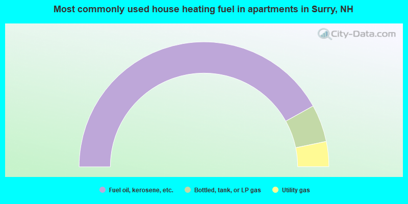
- 83.9%Fuel oil, kerosene, etc.
- 9.7%Bottled, tank, or LP gas
- 6.5%Utility gas
Surry compared to New Hampshire state average:
- Unemployed percentage significantly below state average.
- Black race population percentage significantly below state average.
- Hispanic race population percentage significantly below state average.
- Median age above state average.
- Foreign-born population percentage significantly below state average.
- Renting percentage significantly below state average.
- Length of stay since moving in significantly above state average.
- Number of rooms per house significantly below state average.
- House age significantly below state average.

|
Total of 2 patent applications in 2008-2024.