Kensington, New Hampshire
Submit your own pictures of this town and show them to the world
- OSM Map
- General Map
- Google Map
- MSN Map

Population change since 2000: +12.2%
 |
| Males: 1,063 | |
| Females: 1,061 |
| Median resident age: | 44.6 years |
| New Hampshire median age: | 43.9 years |
Zip codes: 03833.
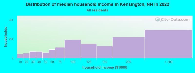
| Kensington: | $124,429 |
| NH: | $89,992 |
Estimated per capita income in 2022: $64,240 (it was $29,265 in 2000)
Kensington town income, earnings, and wages data
Estimated median house or condo value in 2022: $627,313 (it was $205,300 in 2000)
| Kensington: | $627,313 |
| NH: | $384,700 |
Mean prices in 2022: all housing units: $614,227; detached houses: $665,470; townhouses or other attached units: $408,866; in 2-unit structures: $730,084; in 3-to-4-unit structures: over $1,000,000; in 5-or-more-unit structures: $329,099; mobile homes: $126,160
Detailed information about poverty and poor residents in Kensington, NH
Compare current foreclosures near Kensington, NH:
| Photo | Address | Area | Beds / Baths | Price | Details |
|---|---|---|---|---|---|

|
#1
Shore Dr
Hampstead, NH 03841
|
787 sq. feet
|
1 baths 2 beds |
$529,900
|
show details |

|
#2
Brentwood Rd
Exeter, NH 03833
|
2,756 sq. feet
|
2 baths 3 beds |
$419,900
|
show details |

|
#3
Cedar St # A
Haverhill, MA 01830
|
1,134 sq. feet
|
2 baths 2 beds |
$209,300
|
show details |

|
#4
Woodlawn Cir
Portsmouth, NH 03801
|
1,306 sq. feet
|
2 baths 4 beds |
show details | |

|
#5
High St
Exeter, NH 03833
|
3,075 sq. feet
|
3 baths 4 beds |
show details | |

|
#6
Smoke St
Nottingham, NH 03290
|
2,396 sq. feet
|
3 baths 3 beds |
show details | |

|
#7
Mill River Ln
Rowley, MA 01969
|
2,705 sq. feet
|
2 baths 4 beds |
show details | |

|
#8
Redfield Cir
Derry, NH 03038
|
2,124 sq. feet
|
3 baths 4 beds |
show details | |

|
#9
Alder St
Exeter, NH 03833
|
952 sq. feet
|
2 baths 2 beds |
show details | |

|
#10
S Warren St
Haverhill, MA 01835
|
1,356 sq. feet
|
1 baths 3 beds |
show details |
| Photo | Address | Area | Beds / Baths | Price | Details |
|---|---|---|---|---|---|

|
#11
Twin Fawn Run
Chester, NH 03036
|
2,046 sq. feet
|
1 baths 3 beds |
show details | |

|
#12
Peyton Way
Haverhill, MA 01832
|
2,724 sq. feet
|
2 baths 4 beds |
show details | |

|
#13
S Webster St
Haverhill, MA 01835
|
978 sq. feet
|
1 baths 2 beds |
show details | |

|
#14
S Elm St
Haverhill, MA 01835
|
1,122 sq. feet
|
1 baths 4 beds |
show details | |

|
#15
Juniper Wood Dr
Haverhill, MA 01832
|
2,404 sq. feet
|
2 baths 4 beds |
show details | |

|
#16
Providence Hill Rd
Atkinson, NH 03811
|
1,947 sq. feet
|
1 baths 3 beds |
show details | |

|
#17
John St
Haverhill, MA 01830
|
994 sq. feet
|
1 baths 2 beds |
show details | |

|
#18
Washington St
Haverhill, MA 01832
|
3,162 sq. feet
|
5 baths 5 beds |
show details | |

|
#19
Baldwin St
Haverhill, MA 01832
|
2,504 sq. feet
|
2 baths 6 beds |
show details | |

|
#20
Upland Ave
Haverhill, MA 01835
|
1,753 sq. feet
|
2 baths 3 beds |
show details |
| Photo | Address | Area | Beds / Baths | Price | Details |
|---|---|---|---|---|---|

|
#21
Warrenton Rd
Haverhill, MA 01832
|
1,200 sq. feet
|
1 baths 3 beds |
show details | |

|
#22
Cote Cir
Raymond, NH 03077
|
2,024 sq. feet
|
2 baths 3 beds |
show details | |

|
#23
Byfield Rd
Groveland, MA 01834
|
1,488 sq. feet
|
2 baths 3 beds |
show details | |

|
#24
Pine Ave
Haverhill, MA 01832
|
1,159 sq. feet
|
1 baths 4 beds |
show details | |

|
#25
Hazen Ave
Haverhill, MA 01830
|
2,594 sq. feet
|
2 baths 7 beds |
show details | |

|
#26
Old Ferry Rd
Haverhill, MA 01830
|
2,099 sq. feet
|
2 baths 4 beds |
show details | |

|
#27
Mildred Ave
Raymond, NH 03077
|
756 sq. feet
|
2 baths 2 beds |
show details | |

|
#28
Merrill Ave
Haverhill, MA 01830
|
2,416 sq. feet
|
2 baths 4 beds |
show details | |

|
#29
15th Ave
Haverhill, MA 01830
|
1,320 sq. feet
|
1 baths 3 beds |
show details | |

|
#30
Primrose St
Haverhill, MA 01830
|
2,680 sq. feet
|
2 baths 4 beds |
show details |
| Photo | Address | Area | Beds / Baths | Price | Details |
|---|---|---|---|---|---|

|
#31
Plum St
Exeter, NH 03833
|
924 sq. feet
|
1 baths 3 beds |
show details | |

|
#32
Kenoza Ave Apt 1
Haverhill, MA 01830
|
750 sq. feet
|
1 baths 2 beds |
show details | |

|
#33
Boardman St
Haverhill, MA 01830
|
1,092 sq. feet
|
2 baths 3 beds |
show details | |

|
#34
Acorn S 2
Haverhill, MA 01832
|
896 sq. feet
|
1 baths 2 beds |
show details | |

|
#35
Cedar St
Haverhill, MA 01830
|
2,162 sq. feet
|
2 baths 3 beds |
show details | |

|
#36
Hilldale Ave
Haverhill, MA 01832
|
1,456 sq. feet
|
2 baths 2 beds |
show details | |

|
#37
Came Ave
Haverhill, MA 01830
|
1,890 sq. feet
|
1 baths 3 beds |
show details | |

|
#38
Hayden Dr
Atkinson, NH 03811
|
7,205 sq. feet
|
3 baths 4 beds |
show details | |

|
#39
Hilldale Ave # 2
Haverhill, MA 01832
|
2,000 sq. feet
|
2 baths 4 beds |
show details | |

|
#40
King St
Groveland, MA 01834
|
2,713 sq. feet
|
3 baths 4 beds |
show details |
| Photo | Address | Area | Beds / Baths | Price | Details |
|---|---|---|---|---|---|

|
#41
Acorn St # 51
Haverhill, MA 01832
|
896 sq. feet
|
1 baths 2 beds |
show details | |

|
#42
Cedar Point Rd
Durham, NH 03824
|
4,052 sq. feet
|
3 baths 3 beds |
show details | |

|
#43
Sanborn Rd
Derry, NH 03038
|
1,082 sq. feet
|
2 baths 2 beds |
show details | |

|
#44
Washington St
Haverhill, MA 01832
|
864 sq. feet
|
1 baths 2 beds |
show details | |

|
#45
Fenwick Cir
Methuen, MA 01844
|
2,666 sq. feet
|
2 baths 4 beds |
show details | |

|
#46
Town Farm Rd
Chester, NH 03036
|
3,580 sq. feet
|
3 baths 4 beds |
show details | |

|
#47
Back River Rd
Dover, NH 03820
|
1,193 sq. feet
|
1 baths 3 beds |
show details | |

|
#48
Christopher Dr Apt 114
Methuen, MA 01844
|
1,040 sq. feet
|
2 baths 2 beds |
show details | |

|
#49
Spofford St
Georgetown, MA 01833
|
3,594 sq. feet
|
4 baths 5 beds |
show details | |

|
Check over 1 million property listings on Foreclosure.com!
|
browse all offers | |||

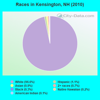
- 2,05296.6%White alone
- 241.1%Hispanic
- 190.9%Asian alone
- 140.7%Two or more races
- 70.3%Black alone
- 50.2%Native Hawaiian and Other
Pacific Islander alone - 30.1%American Indian alone
Races in Kensington detailed stats: ancestries, foreign born residents, place of birth
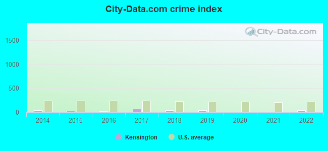
Type |
2014 |
2015 |
2016 |
2017 |
2018 |
2019 |
2020 |
2021 |
2022 |
|---|---|---|---|---|---|---|---|---|---|
| Murders (per 100,000) | 0 (0.0) | 0 (0.0) | 0 (0.0) | 0 (0.0) | 0 (0.0) | 0 (0.0) | 0 (0.0) | 0 (0.0) | 0 (0.0) |
| Rapes (per 100,000) | 0 (0.0) | 0 (0.0) | 0 (0.0) | 1 (47.0) | 1 (46.8) | 1 (47.2) | 0 (0.0) | 0 (0.0) | 1 (47.8) |
| Robberies (per 100,000) | 0 (0.0) | 0 (0.0) | 0 (0.0) | 0 (0.0) | 0 (0.0) | 0 (0.0) | 0 (0.0) | 0 (0.0) | 0 (0.0) |
| Assaults (per 100,000) | 1 (46.9) | 0 (0.0) | 0 (0.0) | 3 (141.1) | 0 (0.0) | 0 (0.0) | 0 (0.0) | 0 (0.0) | 0 (0.0) |
| Burglaries (per 100,000) | 8 (375.4) | 6 (280.4) | 2 (93.8) | 3 (141.1) | 1 (46.8) | 0 (0.0) | 0 (0.0) | 0 (0.0) | 0 (0.0) |
| Thefts (per 100,000) | 6 (281.6) | 8 (373.8) | 4 (187.5) | 1 (47.0) | 2 (93.7) | 2 (94.4) | 4 (189.8) | 3 (141.8) | 2 (95.7) |
| Auto thefts (per 100,000) | 0 (0.0) | 0 (0.0) | 1 (46.9) | 0 (0.0) | 0 (0.0) | 1 (47.2) | 0 (0.0) | 0 (0.0) | 1 (47.8) |
| Arson (per 100,000) | 0 (0.0) | 0 (0.0) | 0 (0.0) | 0 (0.0) | 0 (0.0) | 0 (0.0) | 0 (0.0) | 0 (0.0) | 0 (0.0) |
| City-Data.com crime index | 46.9 | 34.6 | 17.8 | 77.6 | 44.5 | 45.3 | 7.6 | 5.7 | 45.9 |
The City-Data.com crime index weighs serious crimes and violent crimes more heavily. Higher means more crime, U.S. average is 246.1. It adjusts for the number of visitors and daily workers commuting into cities.
Crime rate in Kensington detailed stats: murders, rapes, robberies, assaults, burglaries, thefts, arson
Full-time law enforcement employees in 2021, including police officers: 7 (6 officers - 6 male; 0 female).
| Officers per 1,000 residents here: | 2.84 |
| New Hampshire average: | 2.14 |
 Recent articles from our blog. Our writers, many of them Ph.D. graduates or candidates, create easy-to-read articles on a wide variety of topics.

 | Move to NH - Suggested Areas & Towns? (108 replies) |
| Planning a trip to NH (2 replies) |
| Moving to southeast NH help!!! (48 replies) |
| New Hampshire Farm Stands or Farm Stores (9 replies) |
| NH towns to house shop tomorrow (14 replies) |
| Nicest towns in Southern NH? (19 replies) |
Latest news from Kensington, NH collected exclusively by city-data.com from local newspapers, TV, and radio stations
Ancestries: English (31.4%), Irish (25.3%), Italian (12.2%), French (11.6%), French Canadian (6.8%), German (6.5%).
Current Local Time: EST time zone
Incorporated in 1737
Elevation: 125 feet
Land area: 12.0 square miles.
Population density: 178 people per square mile (very low).
30 residents are foreign born
| This town: | 1.6% |
| New Hampshire: | 4.4% |
| Kensington town: | 1.6% ($3,236) |
| New Hampshire: | 2.3% ($2,946) |
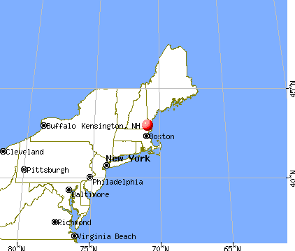
Nearest city with pop. 50,000+: Haverhill, MA  (13.1 miles , pop. 58,969).
Nearest city with pop. 200,000+: Boston, MA (43.3 miles , pop. 589,141).
Nearest city with pop. 1,000,000+: Bronx, NY (208.9 miles , pop. 1,332,650).
Nearest cities:
), ), ), ), ), Latitude: 42.94 N, Longitude: 70.95 W
Area code commonly used in this area: 603

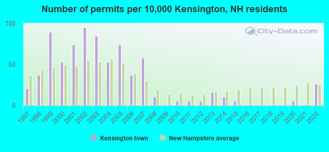
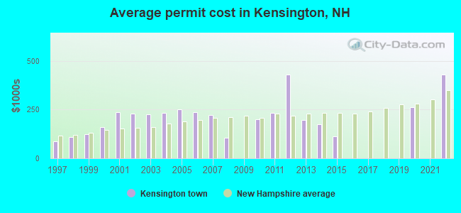
Single-family new house construction building permits:
- 2022: 5 buildings, average cost: $430,000
- 2020: 1 building, cost: $262,400
- 2015: 1 building, cost: $113,400
- 2014: 2 buildings, average cost: $176,200
- 2013: 3 buildings, average cost: $195,700
- 2012: 1 building, cost: $429,000
- 2011: 1 building, cost: $235,000
- 2010: 1 building, cost: $200,200
- 2008: 2 buildings, average cost: $106,900
- 2007: 11 buildings, average cost: $221,200
- 2006: 7 buildings, average cost: $238,200
- 2005: 14 buildings, average cost: $253,200
- 2004: 10 buildings, average cost: $234,100
- 2003: 16 buildings, average cost: $227,300
- 2002: 18 buildings, average cost: $228,000
- 2001: 14 buildings, average cost: $237,000
- 2000: 10 buildings, average cost: $158,600
- 1999: 17 buildings, average cost: $122,900
- 1998: 7 buildings, average cost: $110,300
- 1997: 4 buildings, average cost: $85,500
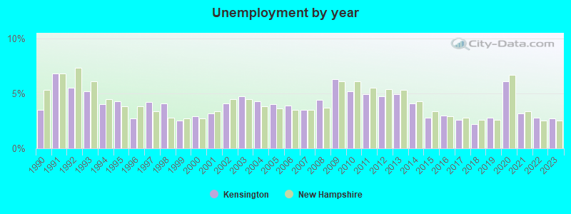
| Here: | 2.7% |
| New Hampshire: | 2.5% |
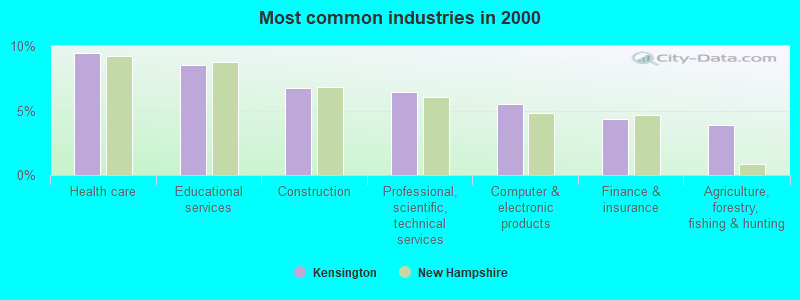
- Health care (9.5%)
- Educational services (8.5%)
- Construction (6.8%)
- Professional, scientific, technical services (6.5%)
- Computer & electronic products (5.5%)
- Finance & insurance (4.3%)
- Agriculture, forestry, fishing & hunting (3.9%)
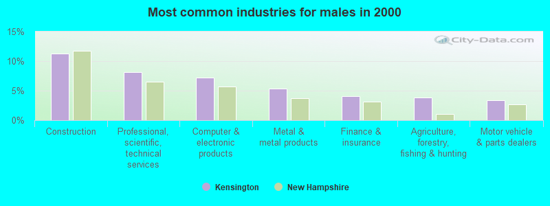
- Construction (11.3%)
- Professional, scientific, technical services (8.1%)
- Computer & electronic products (7.2%)
- Metal & metal products (5.3%)
- Finance & insurance (4.1%)
- Agriculture, forestry, fishing & hunting (3.9%)
- Motor vehicle & parts dealers (3.4%)
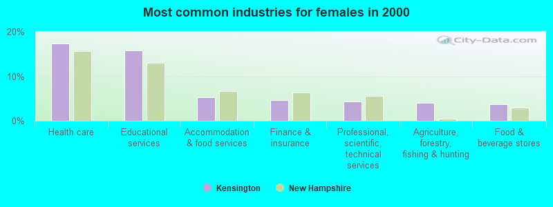
- Health care (17.4%)
- Educational services (15.8%)
- Accommodation & food services (5.3%)
- Finance & insurance (4.6%)
- Professional, scientific, technical services (4.4%)
- Agriculture, forestry, fishing & hunting (4.0%)
- Food & beverage stores (3.7%)
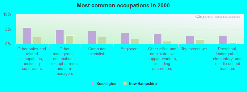
- Other sales and related occupations, including supervisors (5.6%)
- Other management occupations, except farmers and farm managers (4.7%)
- Computer specialists (4.3%)
- Engineers (3.7%)
- Other office and administrative support workers, including supervisors (3.3%)
- Top executives (2.9%)
- Preschool, kindergarten, elementary, and middle school teachers (2.9%)
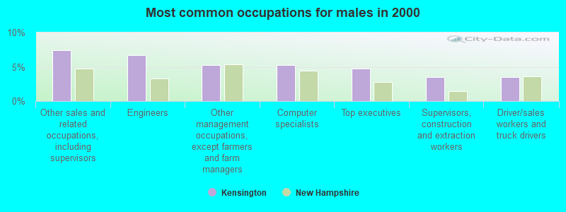
- Other sales and related occupations, including supervisors (7.4%)
- Engineers (6.7%)
- Other management occupations, except farmers and farm managers (5.3%)
- Computer specialists (5.3%)
- Top executives (4.8%)
- Supervisors, construction and extraction workers (3.5%)
- Driver/sales workers and truck drivers (3.5%)
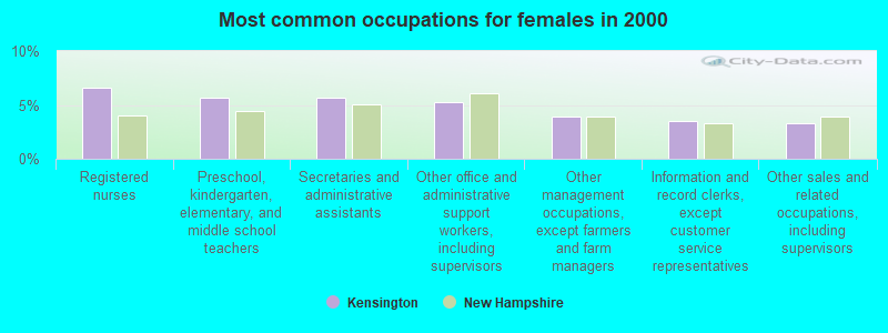
- Registered nurses (6.6%)
- Preschool, kindergarten, elementary, and middle school teachers (5.7%)
- Secretaries and administrative assistants (5.7%)
- Other office and administrative support workers, including supervisors (5.3%)
- Other management occupations, except farmers and farm managers (4.0%)
- Information and record clerks, except customer service representatives (3.5%)
- Other sales and related occupations, including supervisors (3.3%)
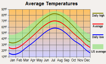
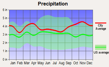
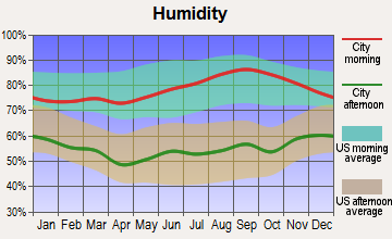
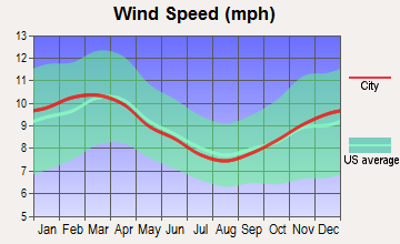
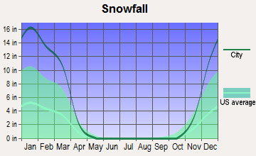
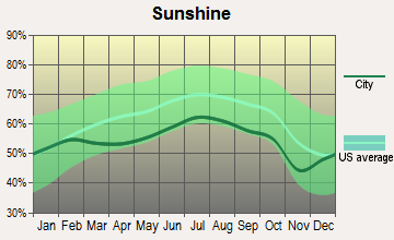
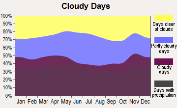
Average climate in Kensington, New Hampshire
Based on data reported by over 4,000 weather stations
(lower is better)
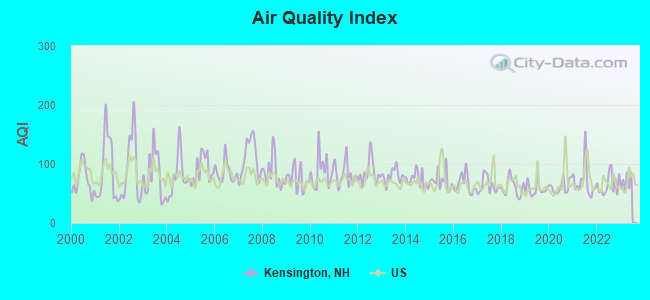
Air Quality Index (AQI) level in 2022 was 65.2. This is about average.
| City: | 65.2 |
| U.S.: | 72.6 |
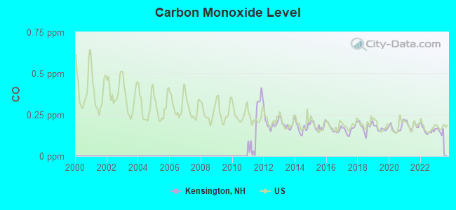
Carbon Monoxide (CO) [ppm] level in 2022 was 0.157. This is significantly better than average. Closest monitor was 13.4 miles away from the city center.
| City: | 0.157 |
| U.S.: | 0.251 |
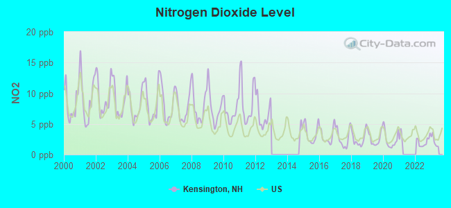
Nitrogen Dioxide (NO2) [ppb] level in 2022 was 2.05. This is significantly better than average. Closest monitor was 9.3 miles away from the city center.
| City: | 2.05 |
| U.S.: | 5.11 |
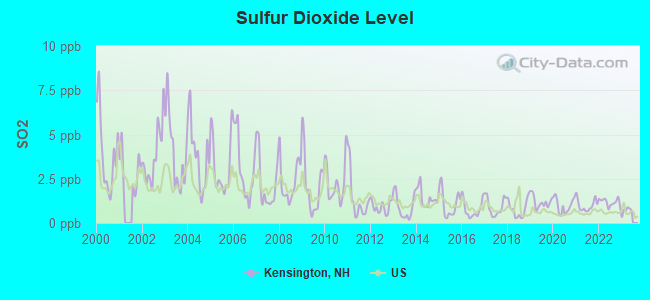
Sulfur Dioxide (SO2) [ppb] level in 2022 was 1.18. This is better than average. Closest monitor was 9.3 miles away from the city center.
| City: | 1.18 |
| U.S.: | 1.51 |
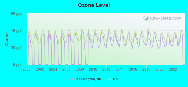
Ozone [ppb] level in 2022 was 29.6. This is about average. Closest monitor was 11.1 miles away from the city center.
| City: | 29.6 |
| U.S.: | 33.3 |
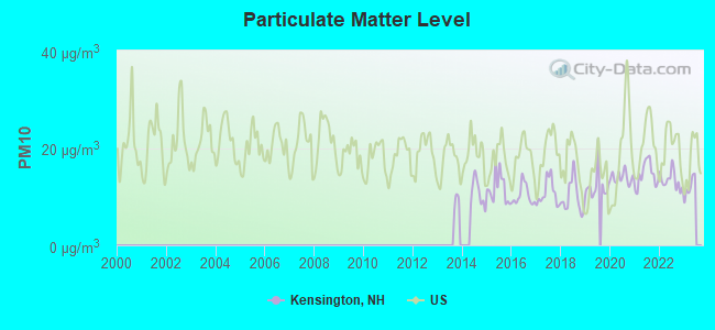
Particulate Matter (PM10) [µg/m3] level in 2022 was 13.4. This is significantly better than average. Closest monitor was 13.4 miles away from the city center.
| City: | 13.4 |
| U.S.: | 19.2 |
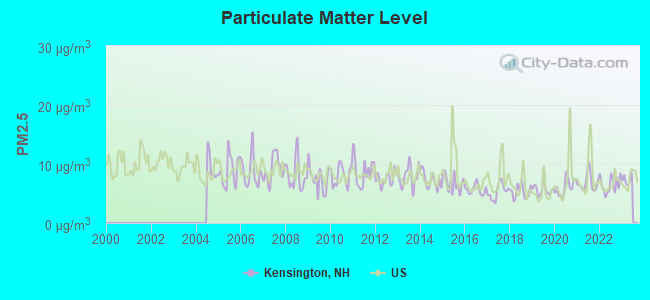
Particulate Matter (PM2.5) [µg/m3] level in 2022 was 6.50. This is better than average. Closest monitor was 13.4 miles away from the city center.
| City: | 6.50 |
| U.S.: | 8.11 |
Tornado activity:
Kensington-area historical tornado activity is near New Hampshire state average. It is 50% smaller than the overall U.S. average.
On 6/9/1953, a category F3 (max. wind speeds 158-206 mph) tornado 2.5 miles away from the Kensington town center injured 5 people and caused between $5000 and $50,000 in damages.
On 9/29/1974, a category F3 tornado 25.5 miles away from the town center injured one person and caused between $50,000 and $500,000 in damages.
Earthquake activity:
Kensington-area historical earthquake activity is significantly above New Hampshire state average. It is 73% smaller than the overall U.S. average.On 10/16/2012 at 23:12:25, a magnitude 4.7 (4.7 ML, Depth: 10.0 mi, Class: Light, Intensity: IV - V) earthquake occurred 47.9 miles away from Kensington center
On 4/20/2002 at 10:50:47, a magnitude 5.3 (5.3 ML, Depth: 3.0 mi, Class: Moderate, Intensity: VI - VII) earthquake occurred 175.3 miles away from the city center
On 1/19/1982 at 00:14:42, a magnitude 4.7 (4.5 MB, 4.7 MD, 4.5 LG) earthquake occurred 50.9 miles away from Kensington center
On 10/7/1983 at 10:18:46, a magnitude 5.3 (5.1 MB, 5.3 LG, 5.1 ML) earthquake occurred 184.3 miles away from the city center
On 4/20/2002 at 10:50:47, a magnitude 5.2 (5.2 MB, 4.2 MS, 5.2 MW, 5.0 MW) earthquake occurred 175.1 miles away from Kensington center
On 8/22/1992 at 12:20:32, a magnitude 4.8 (4.8 MB, 3.8 MS, 4.7 LG, Depth: 6.2 mi) earthquake occurred 267.1 miles away from Kensington center
Magnitude types: regional Lg-wave magnitude (LG), body-wave magnitude (MB), duration magnitude (MD), local magnitude (ML), surface-wave magnitude (MS), moment magnitude (MW)
Natural disasters:
The number of natural disasters in Rockingham County (26) is a lot greater than the US average (15).Major Disasters (Presidential) Declared: 17
Emergencies Declared: 9
Causes of natural disasters: Storms: 12, Floods: 9, Winter Storms: 5, Hurricanes: 4, Snowstorms: 4, Snows: 2, Winds: 2, Blizzard: 1, Snowfall: 1, Tornado: 1 (Note: some incidents may be assigned to more than one category).
Hospitals and medical centers near Kensington:
- RIVERWOODS AT EXETER (Nursing Home, about 3 miles away; EXETER, NH)
- EVENTIDE HOME INC (Nursing Home, about 3 miles away; EXETER, NH)
- FMC DIALYSIS SERVICES OF EXETER (Dialysis Facility, about 4 miles away; EXETER, NH)
- SEACOAST HOSPICE (Hospital, about 4 miles away; EXETER, NH)
- EXETER HOSPITAL INC Acute Care Hospitals (about 4 miles away; EXETER, NH)
- EXETER HEALTHCARE (Nursing Home, about 4 miles away; EXETER, NH)
- EXETER ON HAMPTON CARE AND REHABILITATION CENTER (Nursing Home, about 4 miles away; EXETER, NH)
Airports and heliports located in Kensington:
- Cole Farm Airport (06NH) (Runways: 1)
- Propwash Airport (21NH) (Runways: 1)
- Stumpfield Heliport (05NH)
Operable nuclear power plant near Kensington:
- 7 miles: Seabrook in Seabrook, NH.
Colleges/universities with over 2000 students nearest to Kensington:
- Northern Essex Community College (about 12 miles; Haverhill, MA; Full-time enrollment: 4,737)
- University of New Hampshire-Main Campus (about 14 miles; Durham, NH; FT enrollment: 15,243)
- Merrimack College (about 21 miles; North Andover, MA; FT enrollment: 2,734)
- North Shore Community College (about 24 miles; Danvers, MA; FT enrollment: 5,195)
- Southern New Hampshire University (about 27 miles; Manchester, NH; FT enrollment: 16,552)
- Mount Washington College (about 27 miles; Manchester, NH; FT enrollment: 2,187)
- Endicott College (about 28 miles; Beverly, MA; FT enrollment: 4,064)
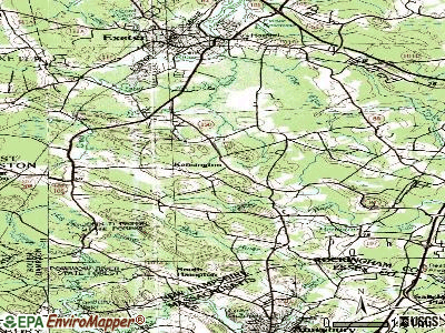
Points of interest:
Notable locations in Kensington: Lambert Farms (A), Kensington Fire Department and Rescue (B), Kensington Town Hall (C), Kensington Social and Public Library (D). Display/hide their locations on the map
Churches in Kensington include: Universalist Church (A), Kensington Congregational Church (B). Display/hide their locations on the map
Lakes and swamps: Muddy Pond (A), Philbrick Pond (B), Great Meadows (C). Display/hide their locations on the map
Streams, rivers, and creeks: Spring Brook (A), Mill Brook (B), Hobbs Brook (C). Display/hide their locations on the map
Birthplace of: Roland D. Sawyer - Congregationalist cleric.
Drinking water stations with addresses in Kensington and their reported violations in the past:
RED IGUANA (Population served: 75, Groundwater):Past monitoring violations:SAWYERS PARK (Population served: 50, Groundwater):
- 7 routine major monitoring violations
Past monitoring violations:
- Monitoring, Source Water (GWR) - Between OCT-01-2011 and NOV-01-2011, Contaminant: E. COLI. Follow-up actions: St Public Notif requested (OCT-20-2011), St Violation/Reminder Notice (OCT-20-2011), St Compliance achieved (OCT-20-2011), St Public Notif received (OCT-25-2011)
- Monitoring, Repeat Major (TCR) - Between JUL-2011 and SEP-2011, Contaminant: Coliform (TCR). Follow-up actions: St Public Notif requested (OCT-20-2011), St Violation/Reminder Notice (OCT-20-2011), St Compliance achieved (OCT-20-2011), St Public Notif received (OCT-25-2011)
| This town: | 2.8 people |
| New Hampshire: | 2.5 people |
| This town: | 78.3% |
| Whole state: | 66.3% |
| This town: | 6.0% |
| Whole state: | 8.3% |
Likely homosexual households (counted as self-reported same-sex unmarried-partner households)
- Lesbian couples: 0.3% of all households
- Gay men: 0.3% of all households
| This town: | 4.6% |
| Whole state: | 6.5% |
| This town: | 2.2% |
| Whole state: | 2.8% |
For population 15 years and over in Kensington:
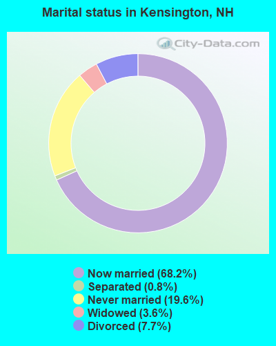
- Never married: 19.6%
- Now married: 68.2%
- Separated: 0.8%
- Widowed: 3.6%
- Divorced: 7.7%
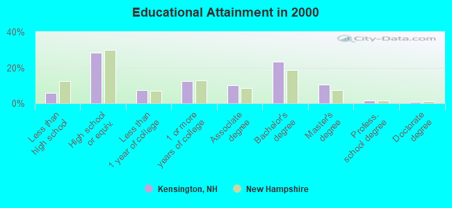
For population 25 years and over in Kensington:
- High school or higher: 94.2%
- Bachelor's degree or higher: 36.1%
- Graduate or professional degree: 12.9%
- Unemployed: 2.9%
- Mean travel time to work (commute): 28.7 minutes
| Here: | 9.3 |
| New Hampshire average: | 10.9 |


Graphs represent county-level data. Detailed 2008 Election Results
Religion statistics for Kensington, NH (based on Rockingham County data)


| Religion | Adherents | Congregations |
|---|---|---|
| Catholic | 84,697 | 24 |
| Mainline Protestant | 19,072 | 78 |
| Evangelical Protestant | 7,456 | 61 |
| Other | 3,490 | 20 |
| Orthodox | 200 | 1 |
| None | 180,308 | - |
Food Environment Statistics:
| Here: | 1.59 / 10,000 pop. |
| State: | 2.14 / 10,000 pop. |
| Rockingham County: | 0.17 / 10,000 pop. |
| New Hampshire: | 0.15 / 10,000 pop. |
| Rockingham County: | 1.86 / 10,000 pop. |
| State: | 1.78 / 10,000 pop. |
| Rockingham County: | 3.31 / 10,000 pop. |
| New Hampshire: | 4.02 / 10,000 pop. |
| This county: | 9.56 / 10,000 pop. |
| New Hampshire: | 9.70 / 10,000 pop. |
| Rockingham County: | 7.6% |
| New Hampshire: | 7.6% |
| Here: | 23.3% |
| New Hampshire: | 24.4% |
| Rockingham County: | 16.8% |
| State: | 15.9% |
7.69% of this county's 2021 resident taxpayers lived in other counties in 2020 ($114,534 average adjusted gross income)
| Here: | 7.69% |
| New Hampshire average: | 7.66% |
0.01% of residents moved from foreign countries ($203 average AGI)
Rockingham County: 0.01% New Hampshire average: 0.01%
Top counties from which taxpayers relocated into this county between 2020 and 2021:
| from Essex County, MA | |
| from Hillsborough County, NH | |
| from Middlesex County, MA |
6.82% of this county's 2020 resident taxpayers moved to other counties in 2021 ($88,778 average adjusted gross income)
| Here: | 6.82% |
| New Hampshire average: | 6.80% |
0.01% of residents moved to foreign countries ($126 average AGI)
Rockingham County: 0.01% New Hampshire average: 0.01%
Top counties to which taxpayers relocated from this county between 2020 and 2021:
| to Hillsborough County, NH | |
| to Strafford County, NH | |
| to Essex County, MA |
Businesses in Kensington, NH
- True Value: 1
Strongest AM radio stations in Kensington:
- WGIP (1540 AM; 5 kW; EXETER, NH; Owner: CAPSTAR TX LIMITED PARTNERSHIP)
- WRKO (680 AM; 50 kW; BOSTON, MA; Owner: ENTERCOM BOSTON LICENSE, LLC)
- WEEI (850 AM; 50 kW; BOSTON, MA; Owner: ENTERCOM BOSTON LICENSE, LLC)
- WDER (1320 AM; 10 kW; DERRY, NH; Owner: BLOUNT COMMUNICATIONS, INC. OF NH)
- WBZ (1030 AM; 50 kW; BOSTON, MA; Owner: INFINITY BROADCASTING OPERATIONS, INC.)
- WWZN (1510 AM; 50 kW; BOSTON, MA; Owner: ROSE CITY RADIO CORPORATION)
- WGIN (930 AM; 10 kW; ROCHESTER, NH; Owner: CAPSTAR TX LIMITED PARTNERSHIP)
- WKOX (1200 AM; 50 kW; FRAMINGHAM, MA; Owner: CAPSTAR TX LIMITED PARTNERSHIP)
- WBIX (1060 AM; 40 kW; NATICK, MA; Owner: LANGER BROADCASTING CORPORATION)
- WTSN (1270 AM; 5 kW; DOVER, NH; Owner: GARRISON CITY BROADCASTING, INC.)
- WCRN (830 AM; 50 kW; WORCESTER, MA; Owner: CARTER BROADCASTING CORPORATION)
- WCEC (1110 AM; daytime; 5 kW; SALEM, NH; Owner: COSTA-EAGLE RADIO VENTURES LTD PARTNERSHIP)
- WGIR (610 AM; 5 kW; MANCHESTER, NH; Owner: CAPSTAR TX LIMITED PARTNERSHIP)
Strongest FM radio stations in Kensington:
- WSAK (102.1 FM; HAMPTON, NH; Owner: CITADEL BROADCASTING COMPANY)
- WNEF (91.7 FM; NEWBURYPORT, MA; Owner: UNIVERSITY OF MASSACHUSETTS)
- WERZ (107.1 FM; EXETER, NH; Owner: CAPSTAR TX LIMITED PARTNERSHIP)
- WXRV (92.5 FM; HAVERHILL, MA; Owner: BEANPOT BROADCASTING CORP.)
- WHEB (100.3 FM; PORTSMOUTH, NH; Owner: CAPSTAR TX LIMITED PARTNERSHIP)
- WUBB (95.3 FM; YORK CENTER, ME; Owner: CAPSTAR TX LIMITED PARTNERSHIP)
- WGIR-FM (101.1 FM; MANCHESTER, NH; Owner: CAPSTAR TX LIMITED PARTNERSHIP)
- WKLB-FM (99.5 FM; LOWELL, MA; Owner: GREATER BOSTON RADIO, INC.)
- WQLL (96.5 FM; BEDFORD, NH; Owner: SAGA COMMUNICATIONS OF NEW ENGLAND, LLC)
- WOKQ (97.5 FM; DOVER, NH; Owner: CITADEL BROADCASTING COMPANY)
- WLMW (90.7 FM; MANCHESTER, NH; Owner: KNOWLEDGE FOR LIFE)
- WZID (95.7 FM; MANCHESTER, NH; Owner: SAGA COMMUNICATIONS OF NEW ENGLAND, LLC)
- WSCY (106.9 FM; MOULTONBOROUGH, NH; Owner: NORTHEAST COMMUNICATIONS CORPORATION)
- WPEA (90.5 FM; EXETER, NH; Owner: TRUSTEES OF THE PHILLIPS EXETER ACADEMY)
- WXKS-FM (107.9 FM; MEDFORD, MA; Owner: AMFM RADIO LICENSES, L.L.C.)
- W227AM (93.3 FM; ANDOVER, MA; Owner: GREATER BOSTON RADIO, INC.)
- WFEX (92.1 FM; PETERBOROUGH, NH; Owner: FNX BROADCASTING OF NEW HAMPSHIRE LLC)
- WMJX (106.7 FM; BOSTON, MA; Owner: GREATER BOSTON RADIO, INC.)
- WSHK (105.3 FM; KITTERY, ME; Owner: CITADEL BROADCASTING COMPANY)
- WQSX (93.7 FM; LAWRENCE, MA; Owner: ENTERCOM BOSTON LICENSE, LLC)
TV broadcast stations around Kensington:
- WHDN-LP (Channel 26; BOSTON, MA; Owner: GUENTER MARKSTEINER)
- WFXZ-CA (Channel 24; BOSTON, MA; Owner: BOSTON BROADCASTING CORP.)
- WMEA-TV (Channel 26; BIDDEFORD, ME; Owner: MAINE PUBLIC BROADCASTING CORP.)
- WCVB-TV (Channel 5; BOSTON, MA; Owner: WCVB HEARST-ARGYLE TV, INC.)
- WGBH-TV (Channel 2; BOSTON, MA; Owner: WGBH EDUCATIONAL FOUNDATION)
- WENH-TV (Channel 11; DURHAM, NH; Owner: UNIVERSITY OF NEW HAMPSHIRE)
- WMFP (Channel 62; LAWRENCE, MA; Owner: WSAH LICENSE, INC.)
- WSBK-TV (Channel 38; BOSTON, MA; Owner: VIACOM INC.)
- WLVI-TV (Channel 56; CAMBRIDGE, MA; Owner: WLVI, INC.)
- WBZ-TV (Channel 4; BOSTON, MA; Owner: VIACOM INC.)
- WGBX-TV (Channel 44; BOSTON, MA; Owner: WGBH EDUCATIONAL FOUNDATION)
- WUTF (Channel 66; MARLBOROUGH, MA; Owner: TELEFUTURA BOSTON LLC)
- WFXT (Channel 25; BOSTON, MA; Owner: FOX TELEVISION STATIONS INC.)
- WBPX (Channel 68; BOSTON, MA; Owner: PAXSON BOSTON-68 LICENSE, INC.)
- WNDS (Channel 50; DERRY, NH; Owner: CTV OF DERRY, INC)
Kensington fatal accident list:
Feb 29, 2016 10:05 PM, Sr-108, Lat: 42.946236, Lon: -70.970933, Vehicles: 1, Persons: 3, Fatalities: 3, Drunk persons involved: 1
Nov 20, 2009 07:30 PM, Sr-107, Sr-150, Lat: 42.906572, Lon: -70.922992, Vehicles: 1, Persons: 1, Fatalities: 1
Mar 18, 2006 04:36 AM, Sr-150, Sr-108, Lat: 42.955950, Lon: -70.959900, Vehicles: 1, Persons: 1, Fatalities: 1, Drunk persons involved: 1
Feb 29, 1992 04:57 AM, 6170068, Vehicles: 1, Persons: 1, Fatalities: 1
May 29, 1989 08:42 PM, 40617, Vehicles: 1, Persons: 1, Fatalities: 1, Drunk persons involved: 1
Mar 11, 1986 07:55 PM, 6174100000, Vehicles: 1, Persons: 1, Fatalities: 1, Drunk persons involved: 1
FCC Registered Antenna Towers:
3- James R Rosencrantz, On Route 107 (Lat: 42.908889 Lon: -70.953611), Type: 60.3, Overall height: 60.3 m, Registrant: Skylines Unlimited Inc, 4052 Getty-sburg, Phone: (717) 337-3656
- James R Rosencrantz, On Route 107 (Lat: 42.908889 Lon: -70.953611), Type: 60.3, Overall height: 60.3 m, Registrant: Skylines Unlimited Inc, 4052 Getty-sburg, Phone: (717) 337-3656
- Anthony Handley, Off South Road (Route 107) (Lat: 42.908250 Lon: -70.953111), Type: 54.9, Structure height: 33015 m, Overall height: 54.9 m, Registrant: Blue Sky Towers Iii, LLC, Chuck.Laurette@blueskytower.Com, Suite 106, North- Reading, Phone: (888) 960-7958
FCC Registered Broadcast Land Mobile Towers:
5- Rosencrantz Tower, On Route 107 (Lat: 42.908889 Lon: -70.953611), Type: Ltower, Structure height: 60.3 m, Call Sign: WNEB875,
Assigned Frequencies: 154.190 MHz, Grant Date: 08/13/2015, Expiration Date: 11/08/2025, Registrant: 2-Way Communications Service, Inc., 19 Durham Street, Portsmouth, NH 03801-2872, Phone: (603) 431-6288, Email:
- So Side Of Rte 107 (Lat: 42.908694 Lon: -70.953111), Call Sign: WQQ313, Licensee ID: L00307774,
Assigned Frequencies: 453.625 MHz, 453.975 MHz, Grant Date: 07/03/2000, Expiration Date: 09/04/2005, Cancellation Date: 08/04/2005, Registrant: State Of New Hampshire, Concord, NH 03302-0483, Phone: (603) 271-2693
- Drinkwater Rd (Lat: 42.953139 Lon: -70.932833), Call Sign: WAF433,
Assigned Frequencies: 173.390 MHz, Grant Date: 06/08/1999, Expiration Date: 06/21/2004, Cancellation Date: 03/13/2002, Registrant: Exeter & Hampton Electric Co, 114 Drinkwater Rd, Kensington, NH 03833-5602, Phone: (603) 772-5916
- KENSINGTON TOWER, On Route 107 (Lat: 42.908889 Lon: -70.953611), Type: Tower, Structure height: 60.3 m, Call Sign: WNFA932,
Assigned Frequencies: 451.050 MHz, 451.675 MHz, Grant Date: 07/14/2021, Expiration Date: 08/14/2031, Registrant: Florida Power & Light Co., 9250 West Flagler St, Miami, FL 33174, Phone: (305) 552-4041, Email:
- Rosencrantz Tower, On Route 107 (Lat: 42.908889 Lon: -70.953611), Type: Ltower, Structure height: 60.3 m, Call Sign: WSAL611,
Assigned Frequencies: 154.950 MHz, 154.815 MHz, 151.482 MHz, Grant Date: 01/26/2024, Expiration Date: 01/26/2034, Certifier: Tobias Dannhausen, Registrant: 2-Way Communications Service, Inc., 19 Durham Street, Portsmouth, NH 03801-2872, Phone: (603) 431-6288, Email:
FCC Registered Microwave Towers:
2- Various Locations (Lat: 42.953139 Lon: -70.932833), Overall height: 6.1 m, Call Sign: WNTY826,
Assigned Frequencies: 956.443 MHz, Grant Date: 10/10/1995, Expiration Date: 10/10/2000, Cancellation Date: 01/21/2001, Phone: (202) 331-9495
- ROSENCRANTS, On Route 107 (Lat: 42.908611 Lon: -70.953667), Type: Ltower, Structure height: 60.3 m, Call Sign: WRZF273, Licensee ID: L00002006,
Assigned Frequencies: 10835.0 MHz, 10835.0 MHz, 10835.0 MHz, 10835.0 MHz, 10835.0 MHz, 10835.0 MHz, 10835.0 MHz, 10835.0 MHz, 10835.0 MHz, 10835.0 MHz, 10835.0 MHz, Grant Date: 10/25/2023, Expiration Date: 10/25/2033, Certifier: Tobias Dannhausen, Registrant: Rockingham County Sheriffs Office, 101 North Road, Brentwood, NH 03833, Phone: (603) 679-9338, Email:
FCC Registered Amateur Radio Licenses:
21 (See the full list of FCC Registered Amateur Radio Licenses in Kensington)FAA Registered Aircraft:
6- Aircraft: SOCATA TB 10 (Category: Land, Seats: 5, Weight: Up to 12,499 Pounds), Engine: LYCOMING O&VO-360 SER (180 HP) (Reciprocating)
N-Number: 115N, N115N, N-115N, Serial Number: 608, Airworthiness Date: 01/20/1986, Certificate Issue Date: 03/21/2000
Registrant (Individual): Constance D Sprauer, 51 Moulton Ridge Rd, Kensington, NH 03833 - Aircraft: PIPER PA-12 (Category: Land, Seats: 3, Weight: Up to 12,499 Pounds, Speed: 82 mph), Engine: LYCOMING 0-235 SERIES (115 HP) (Reciprocating)
N-Number: 7576H, N7576H, N-7576H, Serial Number: 12-447, Year manufactured: 1946, Airworthiness Date: 08/19/1955, Certificate Issue Date: 09/17/2002
Registrant (Partnership): Peter C Brucato, 130 Amesbury Rd, Kensington, NH 03833, Other Owners: Gregory P Brucato - Aircraft: PIPER PA-34-220T (Category: Land, Engines: 2, Seats: 7, Weight: Up to 12,499 Pounds), Engine: CONT MOTOR TSIO-360 SER (225 HP) (Reciprocating)
N-Number: 786MS, N786MS, N-786MS, Serial Number: 3449114, Year manufactured: 1999, Airworthiness Date: 05/14/1999, Certificate Issue Date: 07/19/2017
Registrant (Individual): Kimberly A King, 6 Rose Petal Ln, Kensington, NH 03833 - Aircraft: STINSON 108-1 (Category: Land, Seats: 4, Weight: Up to 12,499 Pounds, Speed: 84 mph), Engine: FRANKLIN 6A4150 SERIES (150 HP) (Reciprocating)
N-Number: 8874K, N8874K, N-8874K, Serial Number: 108-1874, Year manufactured: 1947, Airworthiness Date: 06/04/1955, Certificate Issue Date: 05/21/1987
Registrant (Individual): Peter C Brucato, 130 Amesbury Rd, Kensington, NH 03833 - Aircraft: CESSNA 182Q (Category: Land, Seats: 4, Weight: Up to 12,499 Pounds, Speed: 112 mph), Engine: Reciprocating
N-Number: 4857N, N4857N, N-4857N, Serial Number: 18267423, Certificate Issue Date: 09/16/2014
Registrant (Individual): Hans Peter Tobler, 14 Whipple Way, Kensington, NH 03833
Deregistered: Cancel Date: 04/18/2018 - Aircraft: PIPER PA-24-250 (Category: Land, Seats: 4, Weight: Up to 12,499 Pounds, Speed: 135 mph), Engine: LYCOMING 0-540 SERIES (250 HP) (Reciprocating)
N-Number: 5457P, N5457P, N-5457P, Serial Number: 24-513, Year manufactured: 1958, Airworthiness Date: 11/10/1958, Certificate Issue Date: 11/08/2000
Registrant (Individual): Stephen D Jones, 53 Moulton Ridge Rd, Kensington, NH 03833
Deregistered: Cancel Date: 01/24/2018
2002 - 2018 National Fire Incident Reporting System (NFIRS) incidents
- Fire incident types reported to NFIRS in Kensington, NH
- 8159.1%Structure Fires
- 2115.3%Outside Fires
- 2014.6%Other
- 1510.9%Mobile Property/Vehicle Fires
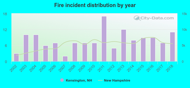 Based on the data from the years 2002 - 2018 the average number of fires per year is 8. The highest number of reported fire incidents - 17 took place in 2011, and the least - 2 in 2007. The data has a growing trend.
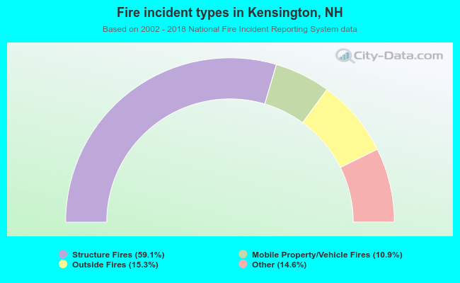 When looking into fire subcategories, the most reports belonged to: Structure Fires (59.1%), and Outside Fires (15.3%).
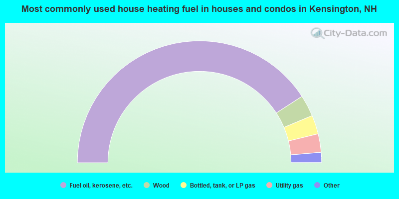
- 81.7%Fuel oil, kerosene, etc.
- 5.7%Wood
- 5.0%Bottled, tank, or LP gas
- 4.9%Utility gas
- 2.3%Electricity
- 0.3%Other fuel
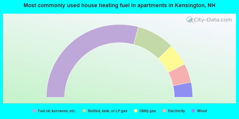
- 58.3%Fuel oil, kerosene, etc.
- 16.7%Bottled, tank, or LP gas
- 10.0%Utility gas
- 8.3%Electricity
- 6.7%Wood
Kensington compared to New Hampshire state average:
- Median house value above state average.
- Unemployed percentage significantly below state average.
- Black race population percentage significantly below state average.
- Hispanic race population percentage significantly below state average.
- Foreign-born population percentage significantly below state average.
- Renting percentage significantly below state average.
- Length of stay since moving in significantly above state average.
- Number of rooms per house significantly below state average.
- House age significantly below state average.

|
|
Total of 63 patent applications in 2008-2024.