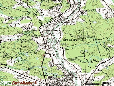
Litchfield, New Hampshire
Submit your own pictures of this town and show them to the world
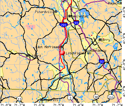
- OSM Map
- General Map
- Google Map
- MSN Map
Population change since 2000: +12.4%
 |
| Males: 4,141 | |
| Females: 4,130 |
| Median resident age: | 40.1 years |
| New Hampshire median age: | 43.9 years |
Zip codes: 03052.
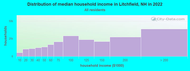
| Litchfield: | $133,083 |
| NH: | $89,992 |
Estimated per capita income in 2022: $50,262 (it was $25,203 in 2000)
Litchfield town income, earnings, and wages data
Estimated median house or condo value in 2022: $459,528 (it was $152,800 in 2000)
| Litchfield: | $459,528 |
| NH: | $384,700 |
Mean prices in 2022: all housing units: $411,252; detached houses: $441,251; townhouses or other attached units: $283,002; in 2-unit structures: $347,377; in 3-to-4-unit structures: $666,663; in 5-or-more-unit structures: $275,798; mobile homes: $132,093
Detailed information about poverty and poor residents in Litchfield, NH
Compare current foreclosures near Litchfield, NH:
| Photo | Address | Area | Beds / Baths | Price | Details |
|---|---|---|---|---|---|

|
#1
Charles Bancroft Hwy
Litchfield, NH 03052
|
- sq. feet
|
- baths - beds |
show details | |

|
#2
Shore Dr
Hampstead, NH 03841
|
787 sq. feet
|
1 baths 2 beds |
$529,900
|
show details |

|
#3
Lydston Ln
Litchfield, NH 03052
|
- sq. feet
|
- baths - beds |
show details | |

|
#4
Colonial Dr
Litchfield, NH 03052
|
- sq. feet
|
- baths - beds |
show details | |

|
#5
Oak Dr
Litchfield, NH 03052
|
- sq. feet
|
- baths - beds |
show details | |

|
#6
Nashua St
Milford, NH 03055
|
2,172 sq. feet
|
2 baths 4 beds |
show details | |

|
#7
High St
Derry, NH 03038
|
2,005 sq. feet
|
3 baths 4 beds |
show details | |

|
#8
3rd Ave
North Chelmsford, MA 01863
|
- sq. feet
|
1 baths 2 beds |
show details | |

|
#9
Brook St
Derry, NH 03038
|
1,476 sq. feet
|
2 baths 4 beds |
show details | |

|
#10
Church St
Goffstown, NH 03045
|
2,115 sq. feet
|
2 baths 4 beds |
show details |
| Photo | Address | Area | Beds / Baths | Price | Details |
|---|---|---|---|---|---|

|
#11
Landsdown Dr
Nashua, NH 03062
|
1,860 sq. feet
|
2 baths 3 beds |
show details | |

|
#12
S Mammoth Rd
Manchester, NH 03109
|
1,555 sq. feet
|
2 baths 4 beds |
show details | |

|
#13
Fieldstone Dr
Amherst, NH 03031
|
2,280 sq. feet
|
3 baths 3 beds |
show details | |

|
#14
Amherst St
Amherst, NH 03031
|
- sq. feet
|
4 baths 3 beds |
show details | |

|
#15
Willow Creek Dr # 42
Hudson, NH 03051
|
1,120 sq. feet
|
1 baths 2 beds |
show details | |

|
#16
Florence St
Dracut, MA 01826
|
1,523 sq. feet
|
2 baths 3 beds |
show details | |

|
#17
Elm St
Manchester, NH 03104
|
4,352 sq. feet
|
3 baths 3 beds |
show details | |

|
#18
Blucher St
Manchester, NH 03102
|
2,448 sq. feet
|
2 baths 3 beds |
show details | |

|
#19
Cheney Dr
Hudson, NH 03051
|
1,685 sq. feet
|
2 baths 3 beds |
show details | |

|
#20
Pine Ridge Rd
Windham, NH 03087
|
1,746 sq. feet
|
2 baths 4 beds |
show details |
| Photo | Address | Area | Beds / Baths | Price | Details |
|---|---|---|---|---|---|

|
#21
Lyons St
Lowell, MA 01852
|
1,314 sq. feet
|
1 baths 2 beds |
show details | |

|
#22
Elm St
Methuen, MA 01844
|
2,232 sq. feet
|
1 baths 3 beds |
show details | |

|
#23
Cluff Crossing Rd
Salem, NH 03079
|
1,120 sq. feet
|
2 baths 2 beds |
show details | |

|
#24
Florence St
Dracut, MA 01826
|
1,523 sq. feet
|
1 baths 3 beds |
show details | |

|
#25
Saint Paul St
Lowell, MA 01851
|
1,550 sq. feet
|
2 baths 3 beds |
show details | |

|
#26
Hallenan Ave
Lawrence, MA 01841
|
1,564 sq. feet
|
1 baths 3 beds |
show details | |

|
#27
Florence St
Dracut, MA 01826
|
1,523 sq. feet
|
1 baths 3 beds |
show details | |

|
#28
Fairview St
Lowell, MA 01852
|
3,868 sq. feet
|
3 baths 5 beds |
show details | |

|
#29
Coral Ave
Manchester, NH 03104
|
2,464 sq. feet
|
2 baths 3 beds |
show details | |

|
#30
Willowdale Rd
Tyngsboro, MA 01879
|
1,896 sq. feet
|
1 baths 3 beds |
show details |
| Photo | Address | Area | Beds / Baths | Price | Details |
|---|---|---|---|---|---|

|
#31
Parkview Ave
Salem, NH 03079
|
1,812 sq. feet
|
1 baths 3 beds |
show details | |

|
#32
Hamilton Ln
Salem, NH 03079
|
2,818 sq. feet
|
2 baths 4 beds |
show details | |

|
#33
Maclarnon Rd
Salem, NH 03079
|
2,020 sq. feet
|
1 baths 3 beds |
show details | |

|
#34
Cannongate Rd Apt 42
Tyngsboro, MA 01879
|
1,436 sq. feet
|
1 baths 2 beds |
show details | |

|
#35
Mammoth Rd
Dracut, MA 01826
|
3,140 sq. feet
|
2 baths 4 beds |
show details | |

|
#36
Auburn Rd
Hooksett, NH 03106
|
1,800 sq. feet
|
2 baths 3 beds |
show details | |

|
#37
Myron St
Dracut, MA 01826
|
1,040 sq. feet
|
2 baths 3 beds |
show details | |

|
#38
Cheyenne Rd
Pepperell, MA 01463
|
1,728 sq. feet
|
2 baths 4 beds |
show details | |

|
#39
Brookline St
Pepperell, MA 01463
|
2,740 sq. feet
|
1 baths 3 beds |
show details | |

|
#40
Red Gate Rd
Tyngsboro, MA 01879
|
3,052 sq. feet
|
2 baths 4 beds |
show details |
| Photo | Address | Area | Beds / Baths | Price | Details |
|---|---|---|---|---|---|

|
#41
Salem St
Methuen, MA 01844
|
1,736 sq. feet
|
2 baths 3 beds |
show details | |

|
#42
Haskell Rd
Pepperell, MA 01463
|
1,440 sq. feet
|
1 baths 3 beds |
show details | |

|
#43
Middlesex Rd
Tyngsboro, MA 01879
|
1,800 sq. feet
|
2 baths 3 beds |
show details | |

|
#44
Whitehall Rd
Hooksett, NH 03106
|
2,740 sq. feet
|
2 baths 5 beds |
show details | |

|
#45
Hollis St
Pepperell, MA 01463
|
1,242 sq. feet
|
1 baths 3 beds |
show details | |

|
#46
East St
Pepperell, MA 01463
|
1,566 sq. feet
|
1 baths 3 beds |
show details | |

|
#47
Dale St
Methuen, MA 01844
|
1,765 sq. feet
|
1 baths 3 beds |
show details | |

|
#48
Washington St
Lowell, MA 01851
|
2,095 sq. feet
|
2 baths 6 beds |
show details | |

|
#49
Donohue Rd Unit 16
Dracut, MA 01826
|
918 sq. feet
|
1 baths 2 beds |
show details | |

|
Check over 1 million property listings on Foreclosure.com!
|
browse all offers | |||

- 7,87195.2%White alone
- 1622.0%Hispanic
- 871.1%Two or more races
- 700.8%Asian alone
- 500.6%Black alone
- 220.3%American Indian alone
- 80.10%Other race alone
- 10.01%Native Hawaiian and Other
Pacific Islander alone
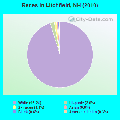
Races in Litchfield detailed stats: ancestries, foreign born residents, place of birth
According to our research of New Hampshire and other state lists, there were 6 registered sex offenders living in Litchfield, New Hampshire as of May 02, 2024.
The ratio of all residents to sex offenders in Litchfield is 1,379 to 1.
The ratio of registered sex offenders to all residents in this city is much lower than the state average.
Type |
2009 |
2010 |
2011 |
2012 |
2013 |
2014 |
2015 |
2016 |
2017 |
2018 |
2019 |
2020 |
2021 |
2022 |
|---|---|---|---|---|---|---|---|---|---|---|---|---|---|---|
| Murders (per 100,000) | 0 (0.0) | 0 (0.0) | 0 (0.0) | 0 (0.0) | 0 (0.0) | 0 (0.0) | 0 (0.0) | 0 (0.0) | 0 (0.0) | 0 (0.0) | 0 (0.0) | 0 (0.0) | 0 (0.0) | 0 (0.0) |
| Rapes (per 100,000) | 3 (33.8) | 2 (24.2) | 1 (12.1) | 1 (12.0) | 1 (12.0) | 1 (12.0) | 1 (11.8) | 0 (0.0) | 1 (11.8) | 0 (0.0) | 1 (11.5) | 0 (0.0) | 0 (0.0) | 1 (11.7) |
| Robberies (per 100,000) | 0 (0.0) | 1 (12.1) | 0 (0.0) | 1 (12.0) | 0 (0.0) | 1 (12.0) | 0 (0.0) | 0 (0.0) | 0 (0.0) | 0 (0.0) | 0 (0.0) | 0 (0.0) | 1 (11.5) | 0 (0.0) |
| Assaults (per 100,000) | 1 (11.3) | 1 (12.1) | 4 (48.3) | 5 (60.2) | 5 (59.9) | 3 (35.9) | 6 (71.0) | 3 (35.4) | 1 (11.8) | 5 (58.6) | 2 (23.1) | 3 (34.6) | 0 (0.0) | 1 (11.7) |
| Burglaries (per 100,000) | 18 (202.6) | 25 (302.3) | 34 (410.5) | 25 (301.0) | 24 (287.6) | 19 (227.2) | 13 (153.8) | 9 (106.1) | 5 (58.8) | 9 (105.4) | 3 (34.6) | 4 (46.1) | 0 (0.0) | 4 (46.8) |
| Thefts (per 100,000) | 88 (990.5) | 65 (785.9) | 59 (712.4) | 51 (613.9) | 29 (347.6) | 41 (490.3) | 40 (473.2) | 21 (247.6) | 21 (246.8) | 47 (550.7) | 23 (265.6) | 19 (218.8) | 16 (184.0) | 9 (105.2) |
| Auto thefts (per 100,000) | 5 (56.3) | 1 (12.1) | 5 (60.4) | 2 (24.1) | 3 (36.0) | 3 (35.9) | 3 (35.5) | 3 (35.4) | 2 (23.5) | 0 (0.0) | 5 (57.7) | 3 (34.6) | 2 (23.0) | 2 (23.4) |
| Arson (per 100,000) | 0 (0.0) | 1 (12.1) | 2 (24.1) | 2 (24.1) | 1 (12.0) | 0 (0.0) | 0 (0.0) | 0 (0.0) | 0 (0.0) | 1 (11.7) | 1 (11.5) | 0 (0.0) | 0 (0.0) | 0 (0.0) |
| City-Data.com crime index | 87.6 | 79.0 | 81.4 | 72.8 | 58.5 | 58.7 | 56.2 | 27.2 | 27.6 | 41.1 | 31.5 | 21.7 | 12.6 | 21.0 |
The City-Data.com crime index weighs serious crimes and violent crimes more heavily. Higher means more crime, U.S. average is 246.1. It adjusts for the number of visitors and daily workers commuting into cities.
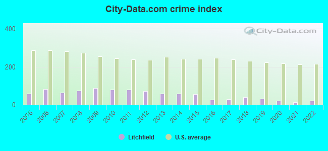
Crime rate in Litchfield detailed stats: murders, rapes, robberies, assaults, burglaries, thefts, arson
Full-time law enforcement employees in 2021, including police officers: 15 (13 officers - 12 male; 1 female).
| Officers per 1,000 residents here: | 1.49 |
| New Hampshire average: | 2.14 |
 Recent articles from our blog. Our writers, many of them Ph.D. graduates or candidates, create easy-to-read articles on a wide variety of topics.

 | Rout 3A Litchfield traffice/noise (3 replies) |
| New Hampshire - Who Puts Voting Ballot in Box ? (25 replies) |
| Nice towns in NH (38 replies) |
| Thoughts on the Free State Project (82 replies) |
| Londonderry vs Bedford (8 replies) |
| Looking for advice on towns in SE NH (21 replies) |
Latest news from Litchfield, NH collected exclusively by city-data.com from local newspapers, TV, and radio stations
Ancestries: Irish (24.1%), English (16.4%), French Canadian (14.6%), French (13.0%), Italian (11.5%), German (7.9%).
Current Local Time: EST time zone
Incorporated in 1734
Elevation: 127 feet
Land area: 15.1 square miles.
Population density: 548 people per square mile (low).
276 residents are foreign born (2.0% North America, 0.8% Europe, 0.7% Africa).
| This town: | 3.8% |
| New Hampshire: | 4.4% |
| Litchfield town: | 2.4% ($3,727) |
| New Hampshire: | 2.3% ($2,946) |
Nearest city with pop. 50,000+: Nashua, NH  (7.0 miles , pop. 86,605).
Nearest city with pop. 200,000+: Boston, MA (41.0 miles , pop. 589,141).
Nearest city with pop. 1,000,000+: Bronx, NY (186.4 miles , pop. 1,332,650).
Nearest cities:
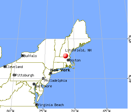
), ), ), Latitude: 42.85 N, Longitude: 71.45 W
Area code commonly used in this area: 603

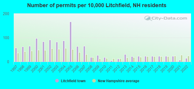
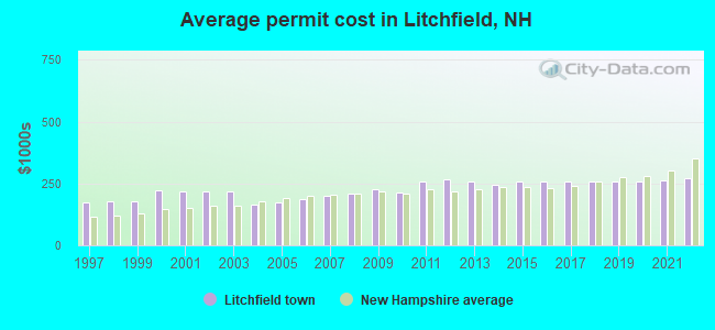
Single-family new house construction building permits:
- 2022: 11 buildings, average cost: $270,500
- 2021: 5 buildings, average cost: $262,500
- 2020: 17 buildings, average cost: $257,200
- 2019: 17 buildings, average cost: $257,200
- 2018: 17 buildings, average cost: $257,200
- 2017: 17 buildings, average cost: $257,200
- 2016: 18 buildings, average cost: $257,200
- 2015: 17 buildings, average cost: $257,200
- 2014: 16 buildings, average cost: $242,500
- 2013: 23 buildings, average cost: $259,900
- 2012: 9 buildings, average cost: $269,300
- 2011: 4 buildings, average cost: $258,800
- 2010: 13 buildings, average cost: $211,900
- 2009: 20 buildings, average cost: $225,100
- 2008: 13 buildings, average cost: $210,100
- 2007: 48 buildings, average cost: $200,300
- 2006: 47 buildings, average cost: $187,500
- 2005: 123 buildings, average cost: $172,000
- 2004: 65 buildings, average cost: $163,600
- 2003: 61 buildings, average cost: $217,600
- 2002: 67 buildings, average cost: $217,900
- 2001: 62 buildings, average cost: $216,600
- 2000: 72 buildings, average cost: $222,200
- 1999: 48 buildings, average cost: $178,800
- 1998: 46 buildings, average cost: $175,800
- 1997: 43 buildings, average cost: $175,400
| Here: | 2.3% |
| New Hampshire: | 2.5% |

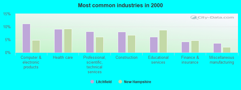
- Computer & electronic products (11.2%)
- Health care (9.1%)
- Professional, scientific, technical services (8.2%)
- Construction (8.0%)
- Educational services (6.1%)
- Finance & insurance (4.2%)
- Miscellaneous manufacturing (3.6%)
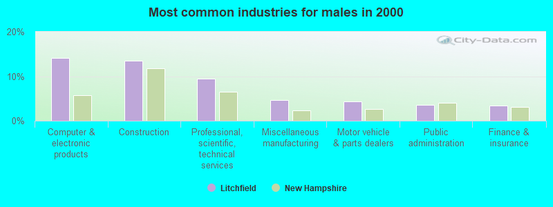
- Computer & electronic products (14.1%)
- Construction (13.4%)
- Professional, scientific, technical services (9.5%)
- Miscellaneous manufacturing (4.6%)
- Motor vehicle & parts dealers (4.4%)
- Public administration (3.6%)
- Finance & insurance (3.4%)
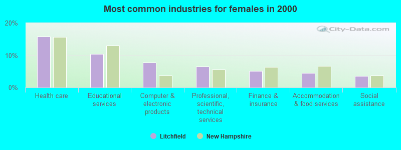
- Health care (15.9%)
- Educational services (10.4%)
- Computer & electronic products (7.8%)
- Professional, scientific, technical services (6.6%)
- Finance & insurance (5.1%)
- Accommodation & food services (4.5%)
- Social assistance (3.6%)
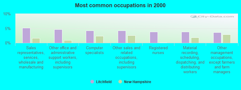
- Sales representatives, services, wholesale and manufacturing (5.1%)
- Other office and administrative support workers, including supervisors (4.6%)
- Computer specialists (4.3%)
- Other sales and related occupations, including supervisors (4.2%)
- Registered nurses (3.8%)
- Material recording, scheduling, dispatching, and distributing workers (3.8%)
- Other management occupations, except farmers and farm managers (3.6%)
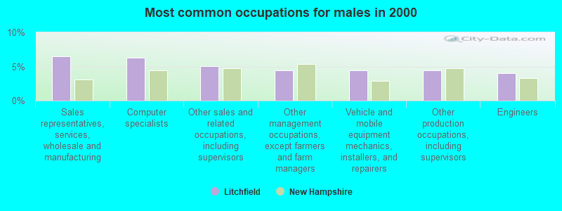
- Sales representatives, services, wholesale and manufacturing (6.5%)
- Computer specialists (6.2%)
- Other sales and related occupations, including supervisors (5.0%)
- Other management occupations, except farmers and farm managers (4.4%)
- Vehicle and mobile equipment mechanics, installers, and repairers (4.4%)
- Other production occupations, including supervisors (4.4%)
- Engineers (4.0%)
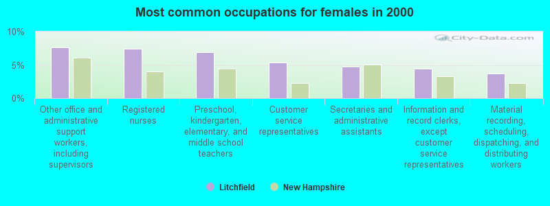
- Other office and administrative support workers, including supervisors (7.6%)
- Registered nurses (7.5%)
- Preschool, kindergarten, elementary, and middle school teachers (6.9%)
- Customer service representatives (5.3%)
- Secretaries and administrative assistants (4.7%)
- Information and record clerks, except customer service representatives (4.4%)
- Material recording, scheduling, dispatching, and distributing workers (3.8%)
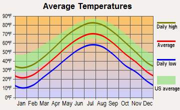
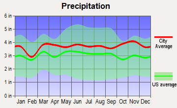
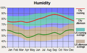
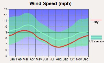
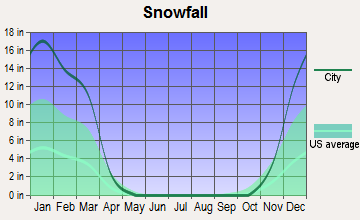
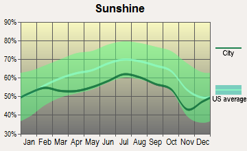
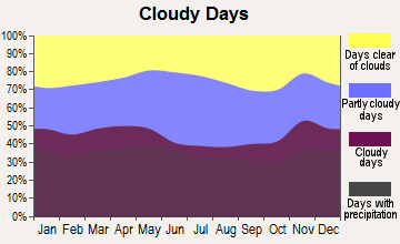
Average climate in Litchfield, New Hampshire
Based on data reported by over 4,000 weather stations
(lower is better)
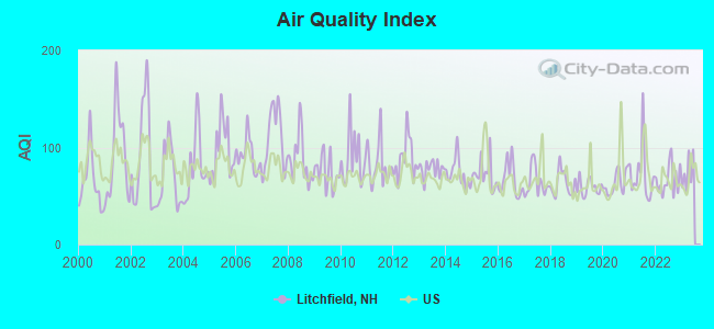
Air Quality Index (AQI) level in 2022 was 66.7. This is about average.
| City: | 66.7 |
| U.S.: | 72.6 |
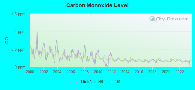
Carbon Monoxide (CO) [ppm] level in 2022 was 0.156. This is significantly better than average. Closest monitor was 3.8 miles away from the city center.
| City: | 0.156 |
| U.S.: | 0.251 |
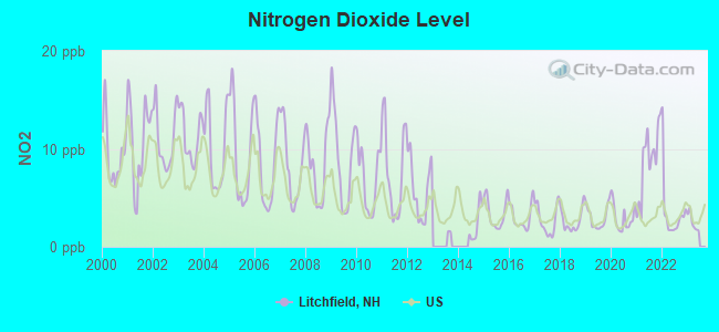
Nitrogen Dioxide (NO2) [ppb] level in 2022 was 3.52. This is significantly better than average. Closest monitor was 3.8 miles away from the city center.
| City: | 3.52 |
| U.S.: | 5.11 |
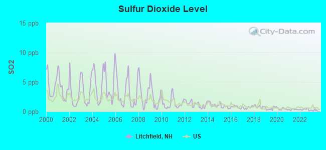
Sulfur Dioxide (SO2) [ppb] level in 2022 was 0.340. This is significantly better than average. Closest monitor was 3.8 miles away from the city center.
| City: | 0.340 |
| U.S.: | 1.515 |

Ozone [ppb] level in 2022 was 29.9. This is about average. Closest monitor was 3.8 miles away from the city center.
| City: | 29.9 |
| U.S.: | 33.3 |
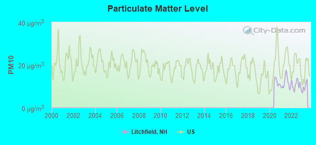
Particulate Matter (PM10) [µg/m3] level in 2022 was 10.6. This is significantly better than average. Closest monitor was 3.8 miles away from the city center.
| City: | 10.6 |
| U.S.: | 19.2 |
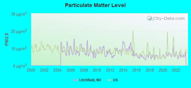
Particulate Matter (PM2.5) [µg/m3] level in 2022 was 5.73. This is significantly better than average. Closest monitor was 3.8 miles away from the city center.
| City: | 5.73 |
| U.S.: | 8.11 |
Tornado activity:
Litchfield-area historical tornado activity is above New Hampshire state average. It is 34% smaller than the overall U.S. average.
On 6/9/1953, a category F4 (max. wind speeds 207-260 mph) tornado 38.2 miles away from the Litchfield town center killed 90 people and injured 1228 people and caused between $50,000,000 and $500,000,000 in damages.
On 10/3/1970, a category F3 (max. wind speeds 158-206 mph) tornado 19.7 miles away from the town center killed one person and caused between $50,000 and $500,000 in damages.
Earthquake activity:
Litchfield-area historical earthquake activity is significantly above New Hampshire state average. It is 72% smaller than the overall U.S. average.On 4/20/2002 at 10:50:47, a magnitude 5.3 (5.3 ML, Depth: 3.0 mi, Class: Moderate, Intensity: VI - VII) earthquake occurred 160.6 miles away from the city center
On 10/7/1983 at 10:18:46, a magnitude 5.3 (5.1 MB, 5.3 LG, 5.1 ML) earthquake occurred 163.9 miles away from the city center
On 1/19/1982 at 00:14:42, a magnitude 4.7 (4.5 MB, 4.7 MD, 4.5 LG, Class: Light, Intensity: IV - V) earthquake occurred 45.5 miles away from Litchfield center
On 4/20/2002 at 10:50:47, a magnitude 5.2 (5.2 MB, 4.2 MS, 5.2 MW, 5.0 MW) earthquake occurred 160.1 miles away from the city center
On 10/16/2012 at 23:12:25, a magnitude 4.7 (4.7 ML, Depth: 10.0 mi) earthquake occurred 65.5 miles away from Litchfield center
On 8/22/1992 at 12:20:32, a magnitude 4.8 (4.8 MB, 3.8 MS, 4.7 LG, Depth: 6.2 mi) earthquake occurred 265.7 miles away from Litchfield center
Magnitude types: regional Lg-wave magnitude (LG), body-wave magnitude (MB), duration magnitude (MD), local magnitude (ML), surface-wave magnitude (MS), moment magnitude (MW)
Natural disasters:
The number of natural disasters in Hillsborough County (27) is a lot greater than the US average (15).Major Disasters (Presidential) Declared: 17
Emergencies Declared: 10
Causes of natural disasters: Storms: 13, Floods: 11, Winter Storms: 5, Snowstorms: 4, Hurricanes: 3, Snows: 3, Blizzard: 1, Ice Storm: 1, Snowfall: 1, Wind: 1 (Note: some incidents may be assigned to more than one category).
Hospitals and medical centers near Litchfield:
- MANCHESTER KIDNEY CENTER (Dialysis Facility, about 6 miles away; MANCHESTER, NH)
- HEALTHY AT HOME (Home Health Center, about 7 miles away; NASHUA, NH)
- NASHUA DIALYSIS (Dialysis Facility, about 7 miles away; NASHUA, NH)
- SOUTHERN NH MEDICAL CENTER Acute Care Hospitals (about 7 miles away; NASHUA, NH)
- TENDER CARE HOME NURSING SERV (Home Health Center, about 7 miles away; DERRY, NH)
- COLUMBIA HOMECARE PARKLAND MEDICAL CTR (Home Health Center, about 8 miles away; DERRY, NH)
- NUTFIELD SURGICENTER (Hospital, about 8 miles away; DERRY, NH)
Heliports located in Litchfield:
Colleges/universities with over 2000 students nearest to Litchfield:
- Mount Washington College (about 9 miles; Manchester, NH; Full-time enrollment: 2,187)
- Saint Anselm College (about 10 miles; Manchester, NH; FT enrollment: 2,059)
- Southern New Hampshire University (about 14 miles; Manchester, NH; FT enrollment: 16,552)
- University of Massachusetts-Lowell (about 16 miles; Lowell, MA; FT enrollment: 12,341)
- Merrimack College (about 21 miles; North Andover, MA; FT enrollment: 2,734)
- Northern Essex Community College (about 21 miles; Haverhill, MA; FT enrollment: 4,737)
- Middlesex Community College (about 25 miles; Bedford, MA; FT enrollment: 6,040)
Public high school in Litchfield:
- CAMPBELL HIGH SCHOOL (Students: 559, Location: 1 HIGHLANDER CT., Grades: 9-12)
Private high school in Litchfield:
- TABERNACLE CHRISTIAN SCHOOL (Students: 94, Location: 242 DERRY RD, Grades: PK-12)
Public elementary/middle schools in Litchfield:
- LITCHFIELD MIDDLE SCHOOL (Students: 564, Location: 19 MCELWAIN DR., Grades: 5-8)
- GRIFFIN MEMORIAL SCHOOL (Students: 540, Location: 229 CHS BANCROFT HWY., Grades: PK-4)
Private elementary/middle school in Litchfield:
- ST FRANCIS OF ASSISI SCHOOL (Students: 93, Location: 9 SAINT FRANCIS WAY, Grades: PK-6)
Points of interest:
Notable locations in Litchfield: Passaconaway Country Club (A), Litchfield New Hampshire Fire Department (B), Litchfield Public Library (C), Litchfield Town Hall (D). Display/hide their locations on the map
Shopping Center: Hudson Village Shops Shopping Center (1). Display/hide its location on the map
Churches in Litchfield include: Tabernacle Baptist Church (A), Litchfield Community Presbyterian Church (B). Display/hide their locations on the map
Cemeteries: Hillcrest Cemetery (1), Pinecrest Cemetery (2). Display/hide their locations on the map
Lakes and swamps: Common Pond (A), Darrah Pond (B), Duck Pond (C), Half Moon Pond (D), Perch Pond (E), Rocky Hill Pond (F), Grassy Pond (G). Display/hide their locations on the map
Streams, rivers, and creeks: Chase Brook (A), Watts Brook (B), Nesenkeag Brook (C), Colby Brook (D). Display/hide their locations on the map
Park in Litchfield: Litchfield Town Park (1). Display/hide its location on the map
Tourist attractions: Mel's Tee Off (Amusement & Theme Parks; 454 Charles Bancroft Hwy) (1), Shirley's Friends at FarPoint Travel- LLC (Tours & Charters; 271 Derry Road) (2). Display/hide their approximate locations on the map
Birthplace of: Mike Konovelchick - College basketball player (Manhattan Jaspers).
Drinking water stations with addresses in Litchfield and their reported violations in the past:
WOODMANS RESTAURANT (Population served: 50, Groundwater):Past health violations:ROMANOS PIZZA (Population served: 50, Groundwater):
- MCL, Monthly (TCR) - Between JUL-2013 and SEP-2013, Contaminant: Coliform. Follow-up actions: St Public Notif requested (JUL-17-2013), St Violation/Reminder Notice (JUL-17-2013), St Public Notif received (JUL-25-2013), St Compliance achieved (APR-10-2014)
Past health violations:Past monitoring violations:
- MCL, Monthly (TCR) - Between JAN-2013 and MAR-2013, Contaminant: Coliform. Follow-up actions: St Public Notif requested (MAR-18-2013), St Violation/Reminder Notice (MAR-18-2013), St Public Notif received (MAR-29-2013), St Compliance achieved (JAN-08-2014)
- Failure To Address Deficiency - In JUN-12-2012, Contaminant: GROUNDWATER RULE. Follow-up actions: St Public Notif requested (JUN-28-2012), St Formal NOV issued (JUN-28-2012), St Compliance achieved (JUL-30-2012), St Public Notif received (AUG-30-2012)
- Monitoring, Repeat Major (TCR) - Between APR-2009 and JUN-2009, Contaminant: Coliform (TCR). Follow-up actions: St Public Notif requested (MAY-28-2009), St Violation/Reminder Notice (MAY-28-2009), St Public Notif received (JUL-20-2009), St Compliance achieved (JUL-30-2009)
- Monitoring, Repeat Major (TCR) - Between OCT-2008 and DEC-2008, Contaminant: Coliform (TCR). Follow-up actions: St Public Notif requested (JAN-05-2009), St Violation/Reminder Notice (JAN-05-2009), St Public Notif received (MAR-03-2009), St Compliance achieved (MAR-16-2009)
- Monitoring, Repeat Major (TCR) - Between JUL-2008 and SEP-2008, Contaminant: Coliform (TCR). Follow-up actions: St Public Notif requested (NOV-10-2008), St Violation/Reminder Notice (NOV-10-2008), St Public Notif received (NOV-24-2008), St Compliance achieved (FEB-09-2009)
- 7 routine major monitoring violations
| This town: | 2.9 people |
| New Hampshire: | 2.5 people |
| This town: | 81.6% |
| Whole state: | 66.3% |
| This town: | 6.8% |
| Whole state: | 8.3% |
Likely homosexual households (counted as self-reported same-sex unmarried-partner households)
- Lesbian couples: 0.5% of all households
- Gay men: 0.2% of all households
| This town: | 2.1% |
| Whole state: | 6.5% |
| This town: | 1.2% |
| Whole state: | 2.8% |
For population 15 years and over in Litchfield:
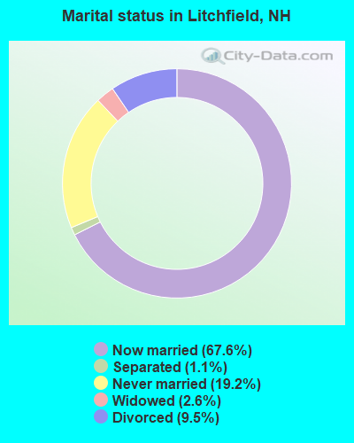
- Never married: 19.2%
- Now married: 67.6%
- Separated: 1.1%
- Widowed: 2.6%
- Divorced: 9.5%
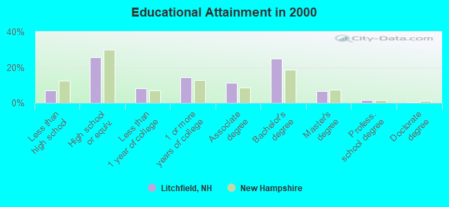
For population 25 years and over in Litchfield:
- High school or higher: 92.9%
- Bachelor's degree or higher: 33.3%
- Graduate or professional degree: 8.3%
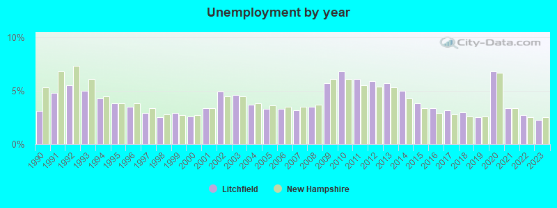
- Unemployed: 2.1%
- Mean travel time to work (commute): 30.9 minutes

| Here: | 9.1 |
| New Hampshire average: | 10.9 |


Graphs represent county-level data. Detailed 2008 Election Results
Religion statistics for Litchfield, NH (based on Hillsborough County data)


| Religion | Adherents | Congregations |
|---|---|---|
| Catholic | 124,993 | 40 |
| Evangelical Protestant | 20,588 | 103 |
| Mainline Protestant | 17,794 | 60 |
| Other | 7,365 | 35 |
| Orthodox | 2,990 | 7 |
| Black Protestant | - | 1 |
| None | 226,991 | - |
Food Environment Statistics:
| This county: | 1.82 / 10,000 pop. |
| New Hampshire: | 2.14 / 10,000 pop. |
| This county: | 0.12 / 10,000 pop. |
| New Hampshire: | 0.15 / 10,000 pop. |
| Hillsborough County: | 1.65 / 10,000 pop. |
| New Hampshire: | 1.78 / 10,000 pop. |
| This county: | 2.67 / 10,000 pop. |
| New Hampshire: | 4.02 / 10,000 pop. |
| Here: | 8.23 / 10,000 pop. |
| New Hampshire: | 9.70 / 10,000 pop. |
| Here: | 6.9% |
| New Hampshire: | 7.6% |
| Hillsborough County: | 24.5% |
| New Hampshire: | 24.4% |
| Hillsborough County: | 15.1% |
| State: | 15.9% |
6.73% of this county's 2021 resident taxpayers lived in other counties in 2020 ($92,767 average adjusted gross income)
| Here: | 6.73% |
| New Hampshire average: | 7.66% |
0.01% of residents moved from foreign countries ($183 average AGI)
Hillsborough County: 0.01% New Hampshire average: 0.01%
Top counties from which taxpayers relocated into this county between 2020 and 2021:
| from Middlesex County, MA | |
| from Rockingham County, NH | |
| from Merrimack County, NH |
6.49% of this county's 2020 resident taxpayers moved to other counties in 2021 ($81,100 average adjusted gross income)
| Here: | 6.49% |
| New Hampshire average: | 6.80% |
0.02% of residents moved to foreign countries ($105 average AGI)
Hillsborough County: 0.02% New Hampshire average: 0.01%
Top counties to which taxpayers relocated from this county between 2020 and 2021:
| to Rockingham County, NH | |
| to Merrimack County, NH | |
| to Middlesex County, MA |
Businesses in Litchfield, NH
- 7-Eleven: 1
- FedEx: 1
- UPS: 1
Strongest AM radio stations in Litchfield:
- WFEA (1370 AM; 5 kW; MANCHESTER, NH; Owner: SAGA COMMUNICATIONS OF NEW ENGLAND, LLC)
- WDER (1320 AM; 10 kW; DERRY, NH; Owner: BLOUNT COMMUNICATIONS, INC. OF NH)
- WRKO (680 AM; 50 kW; BOSTON, MA; Owner: ENTERCOM BOSTON LICENSE, LLC)
- WGIR (610 AM; 5 kW; MANCHESTER, NH; Owner: CAPSTAR TX LIMITED PARTNERSHIP)
- WSMN (1590 AM; 5 kW; NASHUA, NH; Owner: 1590 BROADCASTING CORP.)
- WCEC (1110 AM; daytime; 5 kW; SALEM, NH; Owner: COSTA-EAGLE RADIO VENTURES LTD PARTNERSHIP)
- WEEI (850 AM; 50 kW; BOSTON, MA; Owner: ENTERCOM BOSTON LICENSE, LLC)
- WKBR (1250 AM; 5 kW; MANCHESTER, NH; Owner: DEVON BROADCASTING COMPANY, INC.)
- WWZN (1510 AM; 50 kW; BOSTON, MA; Owner: ROSE CITY RADIO CORPORATION)
- WKOX (1200 AM; 50 kW; FRAMINGHAM, MA; Owner: CAPSTAR TX LIMITED PARTNERSHIP)
- WCRN (830 AM; 50 kW; WORCESTER, MA; Owner: CARTER BROADCASTING CORPORATION)
- WBIX (1060 AM; 40 kW; NATICK, MA; Owner: LANGER BROADCASTING CORPORATION)
- WCAP (980 AM; 5 kW; LOWELL, MA; Owner: NORTHEAST RADIO, INC.)
Strongest FM radio stations in Litchfield:
- WGIR-FM (101.1 FM; MANCHESTER, NH; Owner: CAPSTAR TX LIMITED PARTNERSHIP)
- WQLL (96.5 FM; BEDFORD, NH; Owner: SAGA COMMUNICATIONS OF NEW ENGLAND, LLC)
- WLMW (90.7 FM; MANCHESTER, NH; Owner: KNOWLEDGE FOR LIFE)
- WZID (95.7 FM; MANCHESTER, NH; Owner: SAGA COMMUNICATIONS OF NEW ENGLAND, LLC)
- WHOB (106.3 FM; NASHUA, NH; Owner: TELE-MEDIA COMPANY OF NEW HAMPSHIRE, L.L.C.)
- WFEX (92.1 FM; PETERBOROUGH, NH; Owner: FNX BROADCASTING OF NEW HAMPSHIRE LLC)
- WXRV (92.5 FM; HAVERHILL, MA; Owner: BEANPOT BROADCASTING CORP.)
- WKLB-FM (99.5 FM; LOWELL, MA; Owner: GREATER BOSTON RADIO, INC.)
- W227AM (93.3 FM; ANDOVER, MA; Owner: GREATER BOSTON RADIO, INC.)
- WHDQ (106.1 FM; CLAREMONT, NH; Owner: GREAT NORTHERN RADIO, L.L.C.)
- WBMX (98.5 FM; BOSTON, MA; Owner: INFINITY RADIO OPERATIONS INC.)
- WXKS-FM (107.9 FM; MEDFORD, MA; Owner: AMFM RADIO LICENSES, L.L.C.)
- WJMN (94.5 FM; BOSTON, MA; Owner: AMFM RADIO LICENSES, L.L.C.)
- WCRB (102.5 FM; WALTHAM, MA; Owner: CHARLES RIVER BROADCASTING WCRB LICE)
- WTKK (96.9 FM; BOSTON, MA; Owner: GREATER BOSTON RADIO, INC.)
- WROR-FM (105.7 FM; FRAMINGHAM, MA; Owner: GREATER BOSTON RADIO, INC.)
- WMJX (106.7 FM; BOSTON, MA; Owner: GREATER BOSTON RADIO, INC.)
- WBOS (92.9 FM; BROOKLINE, MA; Owner: GREATER BOSTON RADIO, INC.)
- WVPR (89.5 FM; WINDSOR, VT; Owner: VERMONT PUBLIC RADIO)
- WSCY (106.9 FM; MOULTONBOROUGH, NH; Owner: NORTHEAST COMMUNICATIONS CORPORATION)
TV broadcast stations around Litchfield:
- WNDS (Channel 50; DERRY, NH; Owner: CTV OF DERRY, INC)
- WFXZ-CA (Channel 24; BOSTON, MA; Owner: BOSTON BROADCASTING CORP.)
- WCVB-TV (Channel 5; BOSTON, MA; Owner: WCVB HEARST-ARGYLE TV, INC.)
- WGBH-TV (Channel 2; BOSTON, MA; Owner: WGBH EDUCATIONAL FOUNDATION)
- W29AT (Channel 29; MANCHESTER, NH; Owner: CENTER BROADCASTING CORP. OF NEW HAMPSHIRE)
- WUTF (Channel 66; MARLBOROUGH, MA; Owner: TELEFUTURA BOSTON LLC)
- WYCN-LP (Channel 13; NASHUA, NH; Owner: CENTER BROADCASTING CORP. OF NEW HAMPSHIRE)
- W33AK (Channel 33; NASHUA, NH; Owner: CENTER B/CING CORPORATION OF NEW HAMPSHIRE)
- WUNI (Channel 27; WORCESTER, MA; Owner: ENTRAVISION HOLDINGS, LLC)
- WHDH-TV (Channel 7; BOSTON, MA; Owner: WHDH-TV)
- WMFP (Channel 62; LAWRENCE, MA; Owner: WSAH LICENSE, INC.)
- WBZ-TV (Channel 4; BOSTON, MA; Owner: VIACOM INC.)
- WGBX-TV (Channel 44; BOSTON, MA; Owner: WGBH EDUCATIONAL FOUNDATION)
- WSBK-TV (Channel 38; BOSTON, MA; Owner: VIACOM INC.)
- WLVI-TV (Channel 56; CAMBRIDGE, MA; Owner: WLVI, INC.)
- WMUR-TV (Channel 9; MANCHESTER, NH; Owner: HEARST-ARGYLE PROPERTIES, INC.)
- WFXT (Channel 25; BOSTON, MA; Owner: FOX TELEVISION STATIONS INC.)
- WHDN-LP (Channel 26; BOSTON, MA; Owner: GUENTER MARKSTEINER)
- WMEA-TV (Channel 26; BIDDEFORD, ME; Owner: MAINE PUBLIC BROADCASTING CORP.)
- WBPX (Channel 68; BOSTON, MA; Owner: PAXSON BOSTON-68 LICENSE, INC.)
- WENH-TV (Channel 11; DURHAM, NH; Owner: UNIVERSITY OF NEW HAMPSHIRE)
- W40BO (Channel 40; BOSTON, MA; Owner: PAXSON COMMUNICATIONS LPTV, INC.)
- WTMU-LP (Channel 32; BOSTON, MA; Owner: ZGS BOSTON, INC.)
- WCEA-LP (Channel 58; BOSTON, MA; Owner: CHANNEL 19 TV CORPORATION)
- WNEU (Channel 60; MERRIMACK, NH; Owner: NBC SUBSIDIARY (NH), INC.)

- National Bridge Inventory (NBI) Statistics
- 1Number of bridges
- 3ft / 0.9mTotal length
- $3,142,000Total costs
- 431Total average daily traffic
- 637Total future (year 2042) average daily traffic
FCC Registered Antenna Towers:
20 (See the full list of FCC Registered Antenna Towers in Litchfield)FCC Registered Broadcast Land Mobile Towers:
4- Colonial Drive Tank, Colonial Drive (Lat: 42.855722 Lon: -71.453389), Type: Tank, Structure height: 30.5 m, Overall height: 36.6 m, Call Sign: WNUY927,
Assigned Frequencies: 155.002 MHz, Grant Date: 10/07/2015, Expiration Date: 12/04/2025, Registrant: 2-Way Communications Service, Inc., 19 Durham Street, Portsmouth, NH 03801, Phone: (603) 431-6288, Email:
- Charles Bancraft Hwy (Route 3a) (Lat: 42.883056 Lon: -71.453056), Type: Tower, Structure height: 56.5 m, Call Sign: WDT325,
Assigned Frequencies: 154.650 MHz, Grant Date: 03/06/2013, Expiration Date: 05/04/2023, Cancellation Date: 10/26/2022, Registrant: County Of Hillsborough, 329 Mast Road, Goffstown, NH 03045, Phone: (603) 627-0168, Fax: (603) 627-5634, Email:
- Police Department (Lat: 42.877028 Lon: -71.482556), Call Sign: WXF903,
Assigned Frequencies: 155.475 MHz, 156.090 MHz, Grant Date: 02/10/2023, Expiration Date: 04/15/2033, Registrant: Nh Dept. Of Safety/Emergency Services And Communications, 33 Hazen Dr (Mailing), Concord, NH 03305, Phone: (603) 528-7541, Fax: (603) 271-6629, Email:
- Lat: 42.860000 Lon: -71.453056, Call Sign: WQJX379,
Assigned Frequencies: 462.237 MHz, 467.237 MHz, 462.337 MHz, 467.337 MHz, Grant Date: 04/11/2019, Expiration Date: 02/02/2029, Certifier: Bernie Peabody, Registrant: Cara Enterprises Inc, Salt Lake City, UT 84117-0503, Phone: (801) 278-9728, Fax: (801) 278-7239, Email:
FCC Registered Microwave Towers:
1- LITCHFIELD, Litchfield Road (Lat: 42.883083 Lon: -71.453028), Type: Tower, Structure height: 56.4 m, Overall height: 57.6 m, Call Sign: WLV244,
Assigned Frequencies: 6855.00 MHz, 10622.5 MHz, Grant Date: 01/25/2011, Expiration Date: 02/01/2021, Cancellation Date: 02/25/2014, Registrant: Verizon Wireless, 1120 Sanctuary Pkwy, #150 Gasa5reg, Alpharetta, GA 30009-7630, Phone: (770) 797-1070, Fax: (770) 797-1036, Email:
FCC Registered Amateur Radio Licenses:
70 (See the full list of FCC Registered Amateur Radio Licenses in Litchfield)FAA Registered Aircraft:
3- Aircraft: CAMERON BALLOONS US A-120 (Category: Land, Seats: 5, Weight: Up to 12,499 Pounds), Engine: None
N-Number: 2010J, N2010J, N-2010J, Serial Number: 6502, Year manufactured: 2007, Airworthiness Date: 08/08/2007, Certificate Issue Date: 05/15/2013
Registrant (LLC): Ballooning Center Of New Hampshire LLC, 439 Charles Bancroft Hwy, Litchfield, NH 03052 - Aircraft: CESSNA 210D (Category: Land, Seats: 4, Weight: Up to 12,499 Pounds, Speed: 141 mph), Engine: CONT MOTOR IO 520 SERIES (285 HP) (Reciprocating)
N-Number: 3760Y, N3760Y, N-3760Y, Serial Number: 21058260, Year manufactured: 1963, Airworthiness Date: 12/06/1963, Certificate Issue Date: 08/24/2015
Registrant (Individual): Daniel R Filion, 35 Louise Dr, Litchfield, NH 03052 - Aircraft: CAMERON BALLOONS O-77 (Category: Land, Seats: 4, Weight: Up to 12,499 Pounds, Speed: 60 mph), Engine: None
N-Number: 4505N, N4505N, N-4505N, Serial Number: 6340, Year manufactured: 2003, Airworthiness Date: 02/20/2003, Certificate Issue Date: 05/29/2014
Registrant (LLC): Ballooning Center Of New Hampshire LLC, 439 Charles Bancroft Hwy, Litchfield, NH 03052
2003 - 2018 National Fire Incident Reporting System (NFIRS) incidents
- Fire incident types reported to NFIRS in Litchfield, NH
- 17356.2%Structure Fires
- 10433.8%Outside Fires
- 216.8%Mobile Property/Vehicle Fires
- 103.2%Other
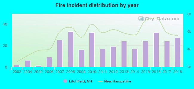 Based on the data from the years 2003 - 2018 the average number of fire incidents per year is 19. The highest number of fires - 33 took place in 2008, and the least - 1 in 2005. The data has an increasing trend.
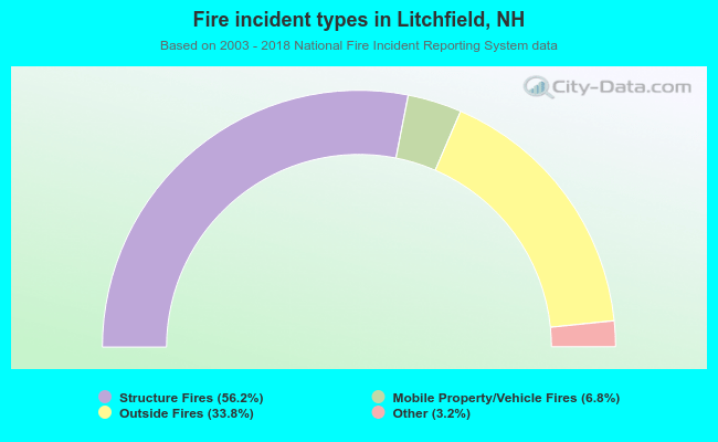 When looking into fire subcategories, the most reports belonged to: Structure Fires (56.2%), and Outside Fires (33.8%).
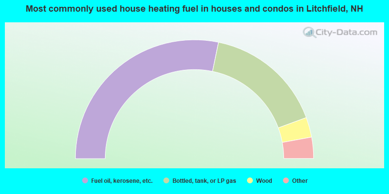
- 56.5%Fuel oil, kerosene, etc.
- 32.3%Bottled, tank, or LP gas
- 5.4%Wood
- 3.0%Electricity
- 2.0%Utility gas
- 0.4%Coal or coke
- 0.3%Other fuel
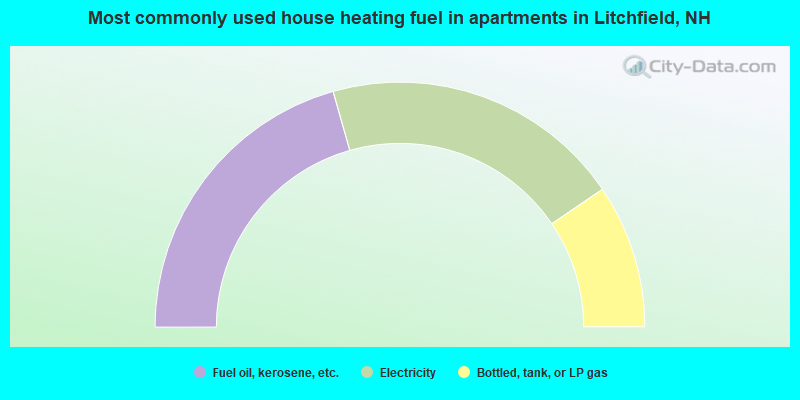
- 41.2%Fuel oil, kerosene, etc.
- 39.8%Electricity
- 19.0%Bottled, tank, or LP gas
Litchfield compared to New Hampshire state average:
- Unemployed percentage significantly below state average.
- Black race population percentage below state average.
- Hispanic race population percentage below state average.
- Foreign-born population percentage below state average.
- Renting percentage significantly below state average.
- Length of stay since moving in significantly above state average.
- Number of rooms per house significantly below state average.
- House age significantly below state average.
Litchfield on our top lists:
- #2 on the list of "Top 101 cities with largest percentage of females in industries: electrical and electronic goods merchant wholesalers (population 5,000+)"
- #3 on the list of "Top 101 cities with largest percentage of females in industries: book stores and news dealers (population 5,000+)"
- #4 on the list of "Top 101 cities with largest percentage of females in industries: furniture and home furnishings, and household appliance stores (population 5,000+)"
- #13 on the list of "Top 101 cities with largest percentage of males in industries: computer and electronic products (population 5,000+)"
- #14 on the list of "Top 101 cities with largest percentage of males in occupations: financial managers (population 5,000+)"
- #16 on the list of "Top 101 cities with largest percentage of females in occupations: customer service representatives (population 5,000+)"
- #16 on the list of "Top 101 cities with largest percentage of females in industries: professional and commercial equipment and supplies merchant wholesalers (population 5,000+)"
- #17 on the list of "Top 101 cities with largest percentage of females in industries: computer and electronic products (population 5,000+)"
- #29 on the list of "Top 101 cities with largest percentage of males in industries: miscellaneous manufacturing (population 5,000+)"
- #34 on the list of "Top 101 cities with largest percentage of males in occupations: supervisors of transportation and material moving workers (population 5,000+)"
- #37 on the list of "Top 101 cities with largest percentage of females in industries: other transportation, and support activities, and couriers (population 5,000+)"
- #45 on the list of "Top 101 cities with largest percentage of females in occupations: registered nurses (population 5,000+)"
- #48 on the list of "Top 101 cities with largest percentage of males in industries: music stores (population 5,000+)"
- #54 on the list of "Top 101 cities with largest percentage of males in industries: motor vehicle and parts dealers (population 5,000+)"
- #56 on the list of "Top 101 cities with largest percentage of females in industries: apparel, fabrics, and notions merchant wholesalers (population 5,000+)"
- #59 on the list of "Top 101 cities with largest percentage of females in occupations: assemblers and fabricators (population 5,000+)"
- #71 on the list of "Top 101 cities with the smallest household incomes disparities (population 5,000+)"
- #72 on the list of "Top 101 cities with largest percentage of males in industries: miscellaneous nondurable goods merchant wholesalers (population 5,000+)"
- #73 on the list of "Top 101 cities with largest percentage of males in occupations: sales representatives, services, wholesale and manufacturing (population 5,000+)"
- #87 on the list of "Top 101 cities with largest percentage of males in industries: electrical equipment, appliances, and components (population 5,000+)"
- #80 (03052) on the list of "Top 101 zip codes with the largest percentage of French Canadian first ancestries (pop 5,000+)"
- #6 on the list of "Top 101 counties with the lowest Particulate Matter (PM10) Annual air pollution readings in 2012 (µg/m3)"
- #12 on the list of "Top 101 counties with the lowest Particulate Matter (PM2.5) Annual air pollution readings in 2012 (µg/m3)"
- #15 on the list of "Top 101 counties with the lowest number of infant deaths per 1000 residents 2007-2013 (pop. 50,000+)"
- #24 on the list of "Top 101 counties with the largest decrease in the number of infant deaths per 1000 residents 2000-2006 to 2007-2013 (pop. 50,000+)"
- #44 on the list of "Top 101 counties with the lowest Nitrogen Dioxide air pollution readings in 2012 (ppm)"

|
|
Total of 296 patent applications in 2008-2024.