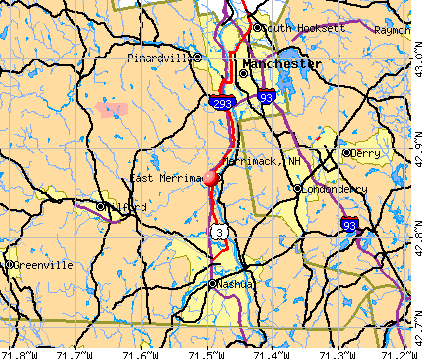
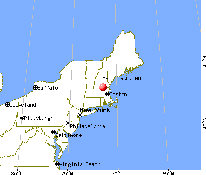
Merrimack, New Hampshire
Submit your own pictures of this town and show them to the world
- OSM Map
- General Map
- Google Map
- MSN Map
Population change since 2000: +1.5%
 |
| Males: 12,685 | |
| Females: 12,809 |
| Median resident age: | 40.7 years |
| New Hampshire median age: | 43.9 years |
Zip codes: 03054.
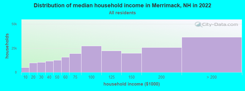
| Merrimack: | $124,940 |
| NH: | $89,992 |
Estimated per capita income in 2022: $55,337 (it was $27,748 in 2000)
Merrimack town income, earnings, and wages data
Estimated median house or condo value in 2022: $418,627 (it was $139,200 in 2000)
| Merrimack: | $418,627 |
| NH: | $384,700 |
Mean prices in 2022: all housing units: $411,252; detached houses: $441,251; townhouses or other attached units: $283,002; in 2-unit structures: $347,377; in 3-to-4-unit structures: $666,663; in 5-or-more-unit structures: $275,798; mobile homes: $132,093
Detailed information about poverty and poor residents in Merrimack, NH


- 23,82893.5%White alone
- 5462.1%Hispanic
- 4982.0%Asian alone
- 3511.4%Two or more races
- 1830.7%Black alone
- 440.2%American Indian alone
- 400.2%Other race alone
- 40.02%Native Hawaiian and Other
Pacific Islander alone
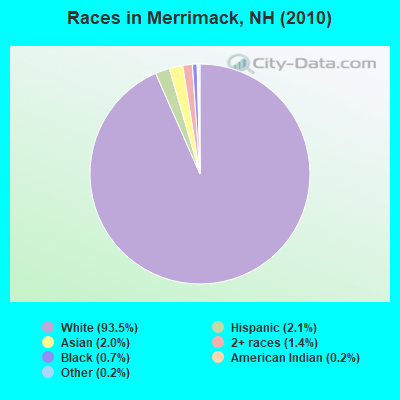
Races in Merrimack detailed stats: ancestries, foreign born residents, place of birth
According to our research of New Hampshire and other state lists, there were 21 registered sex offenders living in Merrimack, New Hampshire as of May 03, 2024.
The ratio of all residents to sex offenders in Merrimack is 1,214 to 1.
The ratio of registered sex offenders to all residents in this city is lower than the state average.
Type |
2009 |
2010 |
2011 |
2012 |
2013 |
2014 |
2015 |
2016 |
2017 |
2018 |
2019 |
2020 |
2021 |
2022 |
|---|---|---|---|---|---|---|---|---|---|---|---|---|---|---|
| Murders (per 100,000) | 1 (3.8) | 0 (0.0) | 0 (0.0) | 0 (0.0) | 0 (0.0) | 0 (0.0) | 1 (3.9) | 0 (0.0) | 0 (0.0) | 0 (0.0) | 0 (0.0) | 0 (0.0) | 0 (0.0) | 0 (0.0) |
| Rapes (per 100,000) | 0 (0.0) | 0 (0.0) | 0 (0.0) | 0 (0.0) | 1 (3.9) | 1 (3.9) | 1 (3.9) | 0 (0.0) | 0 (0.0) | 0 (0.0) | 0 (0.0) | 1 (3.8) | 2 (7.2) | 1 (3.6) |
| Robberies (per 100,000) | 1 (3.8) | 3 (11.8) | 2 (7.8) | 1 (3.9) | 3 (11.7) | 1 (3.9) | 2 (7.8) | 0 (0.0) | 2 (7.8) | 1 (3.9) | 1 (3.8) | 0 (0.0) | 2 (7.2) | 1 (3.6) |
| Assaults (per 100,000) | 0 (0.0) | 6 (23.5) | 0 (0.0) | 5 (19.5) | 2 (7.8) | 2 (7.8) | 3 (11.7) | 0 (0.0) | 4 (15.6) | 5 (19.5) | 2 (7.7) | 4 (15.0) | 2 (7.2) | 4 (14.6) |
| Burglaries (per 100,000) | 40 (150.4) | 53 (207.9) | 53 (207.6) | 34 (132.8) | 28 (109.6) | 19 (74.2) | 20 (77.8) | 22 (85.7) | 14 (54.5) | 12 (46.7) | 21 (80.7) | 20 (75.2) | 7 (25.3) | 2 (7.3) |
| Thefts (per 100,000) | 239 (898.7) | 238 (933.6) | 209 (818.7) | 181 (706.9) | 193 (755.3) | 160 (624.5) | 207 (805.6) | 166 (646.5) | 166 (646.5) | 127 (494.5) | 178 (683.9) | 151 (567.6) | 137 (495.4) | 115 (419.7) |
| Auto thefts (per 100,000) | 8 (30.1) | 10 (39.2) | 7 (27.4) | 9 (35.1) | 8 (31.3) | 10 (39.0) | 6 (23.3) | 3 (11.7) | 4 (15.6) | 6 (23.4) | 9 (34.6) | 14 (52.6) | 7 (25.3) | 0 (0.0) |
| Arson (per 100,000) | 2 (7.5) | 1 (3.9) | 0 (0.0) | 0 (0.0) | 0 (0.0) | 0 (0.0) | 0 (0.0) | 0 (0.0) | 1 (3.9) | 0 (0.0) | 0 (0.0) | 0 (0.0) | 0 (0.0) | 0 (0.0) |
| City-Data.com crime index | 57.5 | 63.3 | 51.8 | 45.5 | 48.6 | 39.1 | 55.1 | 32.8 | 36.4 | 30.0 | 38.5 | 38.2 | 33.0 | 24.2 |
The City-Data.com crime index weighs serious crimes and violent crimes more heavily. Higher means more crime, U.S. average is 246.1. It adjusts for the number of visitors and daily workers commuting into cities.
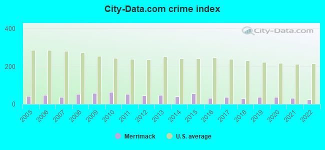
Crime rate in Merrimack detailed stats: murders, rapes, robberies, assaults, burglaries, thefts, arson
Full-time law enforcement employees in 2021, including police officers: 52 (39 officers - 37 male; 2 female).
| Officers per 1,000 residents here: | 1.41 |
| New Hampshire average: | 2.14 |
 Recent articles from our blog. Our writers, many of them Ph.D. graduates or candidates, create easy-to-read articles on a wide variety of topics.

 | House to purachase near Merrimack ,NH (3 replies) |
| Apartment near merrimack? (1 reply) |
| Travel time--Chelmsford to Merrimack (9 replies) |
| Possibly relocating from Georgia for a job in Merrimack (8 replies) |
| Toll Removal (1 reply) |
| Public Lands in Merrimack? (2 replies) |
Latest news from Merrimack, NH collected exclusively by city-data.com from local newspapers, TV, and radio stations
Ancestries: Irish (19.8%), English (16.3%), French (13.9%), French Canadian (11.9%), German (11.5%), Italian (11.4%).
Current Local Time: EST time zone
Incorporated in 1746
Elevation: 180 feet
Land area: 32.6 square miles.
Population density: 782 people per square mile (low).
1,259 residents are foreign born (1.5% Asia, 1.5% North America, 1.4% Europe).
| This town: | 5.0% |
| New Hampshire: | 4.4% |
| Merrimack town: | 2.3% ($3,194) |
| New Hampshire: | 2.3% ($2,946) |
Nearest city with pop. 50,000+: Nashua, NH  (7.6 miles , pop. 86,605).
Nearest city with pop. 200,000+: Boston, MA (42.9 miles , pop. 589,141).
Nearest city with pop. 1,000,000+: Bronx, NY (184.8 miles , pop. 1,332,650).
Nearest cities:
), ), Latitude: 42.86 N, Longitude: 71.51 W
Area code: 603

Merrimack, New Hampshire accommodation & food services, waste management - Economy and Business Data
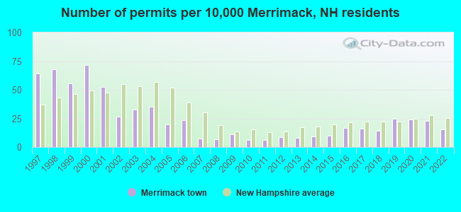
Single-family new house construction building permits:
- 2022: 38 buildings, average cost: $502,500
- 2021: 58 buildings, average cost: $260,700
- 2020: 60 buildings, average cost: $191,900
- 2019: 62 buildings, average cost: $210,500
- 2018: 35 buildings, average cost: $207,600
- 2017: 41 buildings, average cost: $211,000
- 2016: 42 buildings, average cost: $167,100
- 2015: 25 buildings, average cost: $248,100
- 2014: 23 buildings, average cost: $254,500
- 2013: 20 buildings, average cost: $255,500
- 2012: 22 buildings, average cost: $238,800
- 2011: 16 buildings, average cost: $220,600
- 2010: 15 buildings, average cost: $237,000
- 2009: 28 buildings, average cost: $217,100
- 2008: 17 buildings, average cost: $259,600
- 2007: 18 buildings, average cost: $241,800
- 2006: 59 buildings, average cost: $208,700
- 2005: 49 buildings, average cost: $225,900
- 2004: 89 buildings, average cost: $149,200
- 2003: 82 buildings, average cost: $132,200
- 2002: 66 buildings, average cost: $158,200
- 2001: 132 buildings, average cost: $136,000
- 2000: 180 buildings, average cost: $193,700
- 1999: 139 buildings, average cost: $119,400
- 1998: 171 buildings, average cost: $110,100
- 1997: 161 buildings, average cost: $108,500

| Here: | 2.3% |
| New Hampshire: | 2.5% |
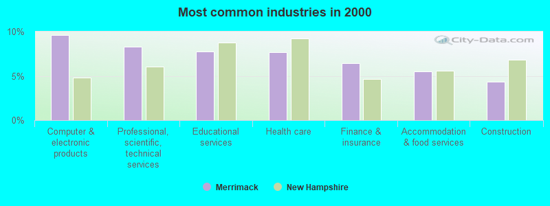
- Computer & electronic products (9.6%)
- Professional, scientific, technical services (8.3%)
- Educational services (7.7%)
- Health care (7.7%)
- Finance & insurance (6.4%)
- Accommodation & food services (5.5%)
- Construction (4.3%)
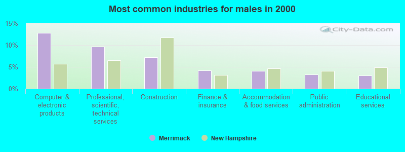
- Computer & electronic products (12.8%)
- Professional, scientific, technical services (9.6%)
- Construction (7.2%)
- Finance & insurance (4.2%)
- Accommodation & food services (4.0%)
- Public administration (3.3%)
- Educational services (3.1%)
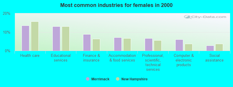
- Health care (13.5%)
- Educational services (13.1%)
- Finance & insurance (8.9%)
- Accommodation & food services (7.2%)
- Professional, scientific, technical services (6.7%)
- Computer & electronic products (6.0%)
- Social assistance (2.9%)
- Computer specialists (6.7%)
- Other management occupations, except farmers and farm managers (5.6%)
- Other sales and related occupations, including supervisors (5.2%)
- Other office and administrative support workers, including supervisors (4.0%)
- Sales representatives, services, wholesale and manufacturing (3.9%)
- Engineers (3.9%)
- Retail sales workers, except cashiers (3.6%)
- Computer specialists (8.5%)
- Other management occupations, except farmers and farm managers (7.0%)
- Engineers (6.6%)
- Other sales and related occupations, including supervisors (5.9%)
- Sales representatives, services, wholesale and manufacturing (4.6%)
- Other production occupations, including supervisors (4.4%)
- Material recording, scheduling, dispatching, and distributing workers (4.2%)

- Other office and administrative support workers, including supervisors (6.6%)
- Preschool, kindergarten, elementary, and middle school teachers (6.2%)
- Secretaries and administrative assistants (5.1%)
- Computer specialists (4.5%)
- Other sales and related occupations, including supervisors (4.5%)
- Other management occupations, except farmers and farm managers (4.1%)
- Registered nurses (4.0%)
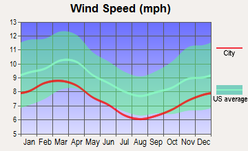
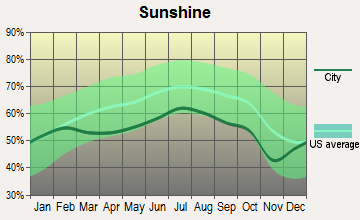
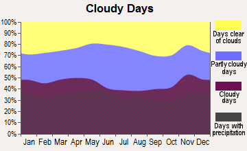
Average climate in Merrimack, New Hampshire
Based on data reported by over 4,000 weather stations


(lower is better)
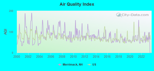
Air Quality Index (AQI) level in 2022 was 66.7. This is about average.
| City: | 66.7 |
| U.S.: | 72.6 |
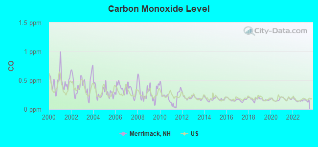
Carbon Monoxide (CO) [ppm] level in 2022 was 0.154. This is significantly better than average. Closest monitor was 6.7 miles away from the city center.
| City: | 0.154 |
| U.S.: | 0.251 |

Nitrogen Dioxide (NO2) [ppb] level in 2022 was 4.10. This is better than average. Closest monitor was 6.7 miles away from the city center.
| City: | 4.10 |
| U.S.: | 5.11 |
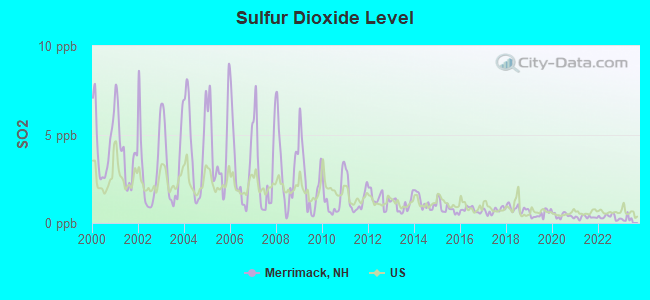
Sulfur Dioxide (SO2) [ppb] level in 2022 was 0.344. This is significantly better than average. Closest monitor was 6.7 miles away from the city center.
| City: | 0.344 |
| U.S.: | 1.515 |

Ozone [ppb] level in 2022 was 29.5. This is about average. Closest monitor was 6.7 miles away from the city center.
| City: | 29.5 |
| U.S.: | 33.3 |
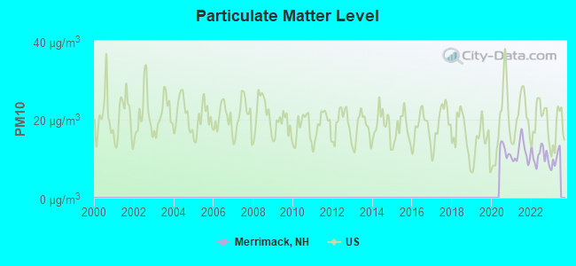
Particulate Matter (PM10) [µg/m3] level in 2022 was 10.6. This is significantly better than average. Closest monitor was 6.7 miles away from the city center.
| City: | 10.6 |
| U.S.: | 19.2 |
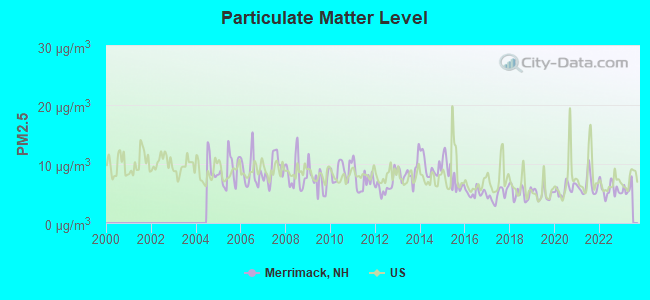
Particulate Matter (PM2.5) [µg/m3] level in 2022 was 5.68. This is significantly better than average. Closest monitor was 6.7 miles away from the city center.
| City: | 5.68 |
| U.S.: | 8.11 |
Tornado activity:
Merrimack-area historical tornado activity is above New Hampshire state average. It is 32% smaller than the overall U.S. average.
On 6/9/1953, a category F4 (max. wind speeds 207-260 mph) tornado 38.6 miles away from the Merrimack town center killed 90 people and injured 1228 people and caused between $50,000,000 and $500,000,000 in damages.
On 10/3/1970, a category F3 (max. wind speeds 158-206 mph) tornado 19.9 miles away from the town center killed one person and caused between $50,000 and $500,000 in damages.
Earthquake activity:
Merrimack-area historical earthquake activity is significantly above New Hampshire state average. It is 71% smaller than the overall U.S. average.On 4/20/2002 at 10:50:47, a magnitude 5.3 (5.3 ML, Depth: 3.0 mi, Class: Moderate, Intensity: VI - VII) earthquake occurred 158.2 miles away from the city center
On 10/7/1983 at 10:18:46, a magnitude 5.3 (5.1 MB, 5.3 LG, 5.1 ML) earthquake occurred 161.1 miles away from Merrimack center
On 1/19/1982 at 00:14:42, a magnitude 4.7 (4.5 MB, 4.7 MD, 4.5 LG, Class: Light, Intensity: IV - V) earthquake occurred 44.6 miles away from Merrimack center
On 4/20/2002 at 10:50:47, a magnitude 5.2 (5.2 MB, 4.2 MS, 5.2 MW, 5.0 MW) earthquake occurred 157.7 miles away from the city center
On 10/16/2012 at 23:12:25, a magnitude 4.7 (4.7 ML, Depth: 10.0 mi) earthquake occurred 66.9 miles away from the city center
On 10/2/1994 at 11:27:22, a magnitude 3.7 (3.5 LG, 3.7 LG, Depth: 6.2 mi, Class: Light, Intensity: II - III) earthquake occurred 52.6 miles away from Merrimack center
Magnitude types: regional Lg-wave magnitude (LG), body-wave magnitude (MB), duration magnitude (MD), local magnitude (ML), surface-wave magnitude (MS), moment magnitude (MW)
Natural disasters:
The number of natural disasters in Hillsborough County (27) is a lot greater than the US average (15).Major Disasters (Presidential) Declared: 17
Emergencies Declared: 10
Causes of natural disasters: Storms: 13, Floods: 11, Winter Storms: 5, Snowstorms: 4, Hurricanes: 3, Snows: 3, Blizzard: 1, Ice Storm: 1, Snowfall: 1, Wind: 1 (Note: some incidents may be assigned to more than one category).

Main business address for: PC CONNECTION INC (RETAIL-CATALOG & MAIL-ORDER HOUSES), BROOKSTONE INC (RETAIL-RETAIL STORES, NEC).
Hospitals and medical centers in Merrimack:
Other hospitals and medical centers near Merrimack:
- MANCHESTER KIDNEY CENTER (Dialysis Facility, about 7 miles away; MANCHESTER, NH)
- HEALTHY AT HOME (Home Health Center, about 8 miles away; NASHUA, NH)
- RIDGEWOOD CENTER, GENESIS HEALTHCARE (Nursing Home, about 8 miles away; BEDFORD, NH)
- ELM'S NURSING AND REHAB CENTER (THE) (Nursing Home, about 8 miles away; MILFORD, NH)
- NASHUA DIALYSIS (Dialysis Facility, about 8 miles away; NASHUA, NH)
- BEDFORD HILLS CARE AND REHABILITATION CENTER (Nursing Home, about 8 miles away; BEDFORD, NH)
- SOUTHERN NH MEDICAL CENTER Acute Care Hospitals (about 8 miles away; NASHUA, NH)
Heliports located in Merrimack:
See details about Heliports located in Merrimack, NHCollege/University in Merrimack:
Colleges/universities with over 2000 students nearest to Merrimack:
- Mount Washington College (about 9 miles; Manchester, NH; Full-time enrollment: 2,187)
- Saint Anselm College (about 9 miles; Manchester, NH; FT enrollment: 2,059)
- Southern New Hampshire University (about 13 miles; Manchester, NH; FT enrollment: 16,552)
- University of Massachusetts-Lowell (about 18 miles; Lowell, MA; FT enrollment: 12,341)
- Fitchburg State University (about 24 miles; Fitchburg, MA; FT enrollment: 5,010)
- Merrimack College (about 24 miles; North Andover, MA; FT enrollment: 2,734)
- Northern Essex Community College (about 24 miles; Haverhill, MA; FT enrollment: 4,737)
Public high school in Merrimack:
- MERRIMACK HIGH SCHOOL (Students: 1,608, Location: 38 MCELWAIN ST., Grades: 9-12)
Private high schools in Merrimack:
- SOUTH MERRIMACK CHRISTIAN ACADEMY (Students: 269, Location: 517 BOSTON POST RD, Grades: UG-12)
- BRENTWOOD SCHOOL (Students: 25, Location: 1 BRENTWOOD DR, Grades: 9-12)
Public elementary/middle schools in Merrimack:
- MERRIMACK MIDDLE SCHOOL (Students: 789, Location: 31 MADELINE BENNETT LN., Grades: 7-8)
- JAMES MASTRICOLA UPPER ELEMENTARY SCHOOL (Students: 748, Location: 26 BABOOSIC LAKE RD., Grades: 5-6)
- THORNTONS FERRY SCHOOL (Students: 586, Location: 134 CAMP SARGENT RD., Grades: KG-4)
- REEDS FERRY SCHOOL (Students: 564, Location: 15 LYONS RD., Grades: PK-4)
- JAMES MASTRICOLA ELEMENTARY SCHOOL (Students: 411, Location: 7 SCHOOL ST., Grades: PK-4)
- GATE CITY CHARTER SCHOOL FOR THE ARTS (Location: 7 HENRY CLAY DR, Grades: KG-6, Charter school)
Private elementary/middle school in Merrimack:
Points of interest:
Notable locations in Merrimack: Camp Sargent (A), Camp Naticook (B), Merrimack Fire Department Station 3 (C), Merrimack Fire Department Station 2 (D), Merrimack Fire Department Station 4 (E), Merrimack Fire Department Station 1 Headquarters (F), Health Stop Center (G), Thomas More College of Liberal Arts Library (H), American Canadian Genealogical Society Library (I), Merrimack Chamber of Commerce (J), Merrimack Public Library (K), Merrimack Town Hall (L), Careplus Ambulance Services Station 1- Merrimack Headquarters (M). Display/hide their locations on the map
Shopping Centers: Merrimack Village Mall Shopping Center (1), Pennichuck Square Shopping Center (2), The Commons Shopping Center (3). Display/hide their locations on the map
Main business address in Merrimack include: PC CONNECTION INC (A), BROOKSTONE INC (B). Display/hide their locations on the map
Churches in Merrimack include: South Merrimack Congregational Church (A), Our Lady of Mercy Catholic Church (B), Faith Episcopal Church (C), First Congregational Church (D). Display/hide their locations on the map
Cemeteries: Turkey Hill Cemetery (1), Last Rest Cemetery (2), Reeds Cemetery (3). Display/hide their locations on the map
Lakes, reservoirs, and swamps: Duck Pond (A), Greens Pond (B), Horseshoe Pond (C), Beaver Ponds (D), Souhegan River Reservoir (E), Bowers Pond (F), Harris Pond (G), Holts Pond (H). Display/hide their locations on the map
Streams, rivers, and creeks: Souhegan River (A), Riddle Brook (B), Witches Brook (C), Naticook Brook (D), McQuade Brook (E), Baboosic Brook (F). Display/hide their locations on the map
Parks in Merrimack include: Veterans Memorial Park (1), Wasseman Park (2), Kids Kove (3). Display/hide their locations on the map
Tourist attractions: Merrimack Historical Society (Cultural Attractions- Events- & Facilities; 520 Boston Post Road) (1), Ambassador World Travel & Cruise Center (Tours & Charters; The Commons Route 3) (2). Display/hide their approximate locations on the map
Hotels: Fairfield Inn Merrimack (4 Amherst Road) (1), Residence Inn by Marriott Merrimack (246 Daniel Webster Highway) (2), Residence Inn Nashua- Merrimack (246 Daniel Webster Highway) (3). Display/hide their approximate locations on the map
Court: Merrimack Town - Probation Dept- Town Ofcs- District Court (Baboosic Lake Road) (1). Display/hide its approximate location on the map
Birthplace of: Forrest Sherman - Recipient of the Purple Heart medal, Carlos W. Colby - Recipient of the Medal of Honor, P.J. Flaherty - College basketball player (Brown Bears).
Drinking water stations with addresses in Merrimack and their reported violations in the past:
PENNICHUCK WATER WORKS (Population served: 86,630, Surface water):Past monitoring violations:MERRIMACK VILLAGE DIST (Population served: 25,000, Groundwater):
- Follow-up Or Routine LCR Tap M/R - In OCT-01-2008, Contaminant: Lead and Copper Rule. Follow-up actions: St Violation/Reminder Notice (NOV-07-2008), St Compliance achieved (NOV-10-2008)
Past health violations:PEU/LONDONDERRY (Population served: 4,740, Purch surface water):Past monitoring violations:
- MCL, Monthly (TCR) - In JUL-2009, Contaminant: Coliform. Follow-up actions: St Violation/Reminder Notice (JUL-30-2009), St Public Notif requested (JUL-30-2009), St Public Notif received (OCT-21-2009), St Compliance achieved (FEB-16-2010)
- Follow-up Or Routine LCR Tap M/R - In OCT-01-2008, Contaminant: Lead and Copper Rule. Follow-up actions: St Public Notif requested (NOV-07-2008), St Violation/Reminder Notice (NOV-07-2008), St Compliance achieved (NOV-10-2008), St Public Notif received (DEC-02-2008)
Past monitoring violations:PEU/LITCHFIELD (Population served: 3,608, Purch groundwater):
- Monitoring and Reporting (DBP) - Between OCT-01-2013 and JAN-01-2014, Contaminant: Total Haloacetic Acids (HAA5). Follow-up actions: St Public Notif requested (MAR-24-2014), St Violation/Reminder Notice (MAR-24-2014), St Public Notif received (APR-10-2014), St Compliance achieved (JUN-04-2014)
- Monitoring and Reporting (DBP) - Between OCT-01-2013 and JAN-01-2014, Contaminant: TTHM. Follow-up actions: St Public Notif requested (MAR-24-2014), St Violation/Reminder Notice (MAR-24-2014), St Public Notif received (APR-10-2014), St Compliance achieved (JUN-04-2014)
Past monitoring violations:PEU/LOCKE LAKE (Population served: 2,120, Groundwater):
- Monitoring and Reporting (DBP) - Between JUL-01-2010 and OCT-01-2010, Contaminant: Chlorine. Follow-up actions: St Violation/Reminder Notice (OCT-27-2010), St Compliance achieved (MAR-16-2011)
Past health violations:DREW WOODS (Population served: 1,313, Purch surface water):Past monitoring violations:
- MCL, Monthly (TCR) - In AUG-2012, Contaminant: Coliform. Follow-up actions: St Public Notif requested (AUG-07-2012), St Violation/Reminder Notice (AUG-07-2012), St Public Notif received (AUG-10-2012), St Formal NOV issued (SEP-18-2012), St Compliance achieved (FEB-13-2013)
- MCL, Monthly (TCR) - In MAR-2012, Contaminant: Coliform. Follow-up actions: St Public Notif requested (MAR-13-2012), St Violation/Reminder Notice (MAR-13-2012), St Public Notif received (MAR-28-2012), St Formal NOV issued (SEP-18-2012), St Compliance achieved (FEB-13-2013)
- MCL, Average - Between JUL-2007 and SEP-2007, Contaminant: Arsenic. Follow-up actions: St Public Notif requested (NOV-16-2007), St Violation/Reminder Notice (NOV-16-2007), St Public Notif received (NOV-26-2007), St Compliance achieved (AUG-18-2008)
- MCL, Average - Between APR-2007 and JUN-2007, Contaminant: Arsenic. Follow-up actions: St Public Notif requested (JUN-19-2007), St Violation/Reminder Notice (JUN-19-2007), St Public Notif received (JUN-25-2007), St Compliance achieved (AUG-18-2008)
- MCL, Average - Between JAN-2007 and MAR-2007, Contaminant: Arsenic. Follow-up actions: St Public Notif requested (APR-19-2007), St Violation/Reminder Notice (APR-19-2007), St Public Notif received (MAY-04-2007), St Compliance achieved (AUG-18-2008)
- Monitoring, Source Water (GWR) - Between AUG-08-2012 and SEP-08-2012, Contaminant: E. COLI. Follow-up actions: St Violation/Reminder Notice (SEP-19-2012), St Compliance achieved (OCT-10-2012)
- Monitoring and Reporting (DBP) - Between JUL-01-2010 and OCT-01-2010, Contaminant: Chlorine. Follow-up actions: St Violation/Reminder Notice (OCT-27-2010), St Compliance achieved (MAR-16-2011)
- One routine major monitoring violation
Past monitoring violations:CABOT PRESERVE (Population served: 940, Purch groundwater):
- Monitoring and Reporting (DBP) - Between JUL-01-2010 and OCT-01-2010, Contaminant: Chlorine. Follow-up actions: St Violation/Reminder Notice (OCT-27-2010), St Compliance achieved (MAR-16-2011)
- Follow-up Or Routine LCR Tap M/R - In JAN-01-2009, Contaminant: Lead and Copper Rule. Follow-up actions: St Public Notif requested (NOV-03-2009), St Violation/Reminder Notice (NOV-03-2009), St Compliance achieved (NOV-06-2009), St Public Notif received (NOV-12-2009)
Past monitoring violations:PEU/BROOK PARK ESTS (Population served: 846, Purch surface water):
- Monitoring and Reporting (DBP) - Between JUL-01-2010 and OCT-01-2010, Contaminant: Chlorine. Follow-up actions: St Violation/Reminder Notice (OCT-27-2010), St Compliance achieved (MAR-16-2011)
Past monitoring violations:
- Follow-up Or Routine LCR Tap M/R - In OCT-01-2006, Contaminant: Lead and Copper Rule. Follow-up actions: St Public Notif requested (FEB-13-2007), St Violation/Reminder Notice (FEB-13-2007), St Compliance achieved (FEB-15-2007), St Public Notif received (FEB-26-2007)
Drinking water stations with addresses in Merrimack that have no violations reported:
- LITTLE POND ESTATES (Population served: 2,425, Primary Water Source Type: Purch surface water)
- PEU/OAKWOOD TERRACE (Population served: 305, Primary Water Source Type: Purch surface water)
- PEU/SPRINGWOOD HILLS (Population served: 218, Primary Water Source Type: Purch surface water)
- MAPLE HAVEN (Population served: 95, Primary Water Source Type: Groundwater)
- PEU/NORTHERN SHORES (Population served: 75, Primary Water Source Type: Groundwater)
- ENGLISH WOODS (Population served: 50, Primary Water Source Type: Groundwater)
- PEU/STONE SLED FARM (Population served: 41, Primary Water Source Type: Groundwater)
| This town: | 2.7 people |
| New Hampshire: | 2.5 people |
| This town: | 75.2% |
| Whole state: | 66.3% |
| This town: | 6.6% |
| Whole state: | 8.3% |
Likely homosexual households (counted as self-reported same-sex unmarried-partner households)
- Lesbian couples: 0.3% of all households
- Gay men: 0.3% of all households
| This town: | 1.9% |
| Whole state: | 6.5% |
| This town: | 0.7% |
| Whole state: | 2.8% |
People in group quarters in Merrimack in 2010:
- 52 people in college/university student housing
- 28 people in nursing facilities/skilled-nursing facilities
- 6 people in in-patient hospice facilities
- 4 people in group homes intended for adults
- 4 people in workers' group living quarters and job corps centers
24 people in other noninstitutional group quarters in 2000
Banks with branches in Merrimack (2011 data):
- Bank of America, National Association: Commons Shopping Center Branch at 360 Daniel Webster Highway, branch established on 1888/01/01. Info updated 2009/11/18: Bank assets: $1,451,969.3 mil, Deposits: $1,077,176.8 mil, headquarters in Charlotte, NC, positive income, 5782 total offices, Holding Company: Bank Of America Corporation
- People's United Bank: Pennichuck Square Branch at 707 Milford Road, branch established on 1997/02/18. Info updated 2012/02/16: Bank assets: $27,319.3 mil, Deposits: $20,835.4 mil, headquarters in Bridgeport, CT, positive income, Commercial Lending Specialization, 374 total offices
- Fidelity Personal Trust Company, FSB: Fptc New Hampshire Office Branch at Two Contra Way, branch established on 2004/10/25. Info updated 2011/07/21: Bank assets: $98.3 mil, Deposits: $50.5 mil, headquarters in Boston, MA, positive income, 4 total offices
- Sovereign Bank, National Association: Merrimack Branch at 421 Daniel Webster Highway, branch established on 1964/03/02. Info updated 2012/01/31: Bank assets: $78,146.9 mil, Deposits: $48,042.9 mil, headquarters in Wilmington, DE, positive income, Commercial Lending Specialization, 718 total offices, Holding Company: Banco Santander, S.A.
- TD Bank, National Association: Merrimack Branch at 300 Daniel Webster Hwy., branch established on 1969/04/21. Info updated 2010/10/04: Bank assets: $188,912.6 mil, Deposits: $153,149.8 mil, headquarters in Wilmington, DE, positive income, 1314 total offices, Holding Company: Toronto-Dominion Bank, The
- RBS Citizens, National Association: Merrimack Branch at 268 Daniel Webster Hwy., South, branch established on 1978/01/28. Info updated 2007/09/19: Bank assets: $106,940.6 mil, Deposits: $75,690.2 mil, headquarters in Providence, RI, positive income, 1135 total offices, Holding Company: Uk Financial Investments Limited
For population 15 years and over in Merrimack:
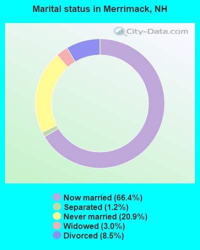
- Never married: 20.9%
- Now married: 66.4%
- Separated: 1.2%
- Widowed: 3.0%
- Divorced: 8.5%
For population 25 years and over in Merrimack:
- High school or higher: 92.9%
- Bachelor's degree or higher: 35.0%
- Graduate or professional degree: 9.8%
- Unemployed: 2.9%
- Mean travel time to work (commute): 25.6 minutes

| Here: | 9.2 |
| New Hampshire average: | 10.9 |


Graphs represent county-level data. Detailed 2008 Election Results
Religion statistics for Merrimack, NH (based on Hillsborough County data)


| Religion | Adherents | Congregations |
|---|---|---|
| Catholic | 124,993 | 40 |
| Evangelical Protestant | 20,588 | 103 |
| Mainline Protestant | 17,794 | 60 |
| Other | 7,365 | 35 |
| Orthodox | 2,990 | 7 |
| Black Protestant | - | 1 |
| None | 226,991 | - |
Food Environment Statistics:
| Here: | 1.82 / 10,000 pop. |
| New Hampshire: | 2.14 / 10,000 pop. |
| Hillsborough County: | 0.12 / 10,000 pop. |
| New Hampshire: | 0.15 / 10,000 pop. |
| Hillsborough County: | 1.65 / 10,000 pop. |
| New Hampshire: | 1.78 / 10,000 pop. |
| Hillsborough County: | 2.67 / 10,000 pop. |
| State: | 4.02 / 10,000 pop. |
| This county: | 8.23 / 10,000 pop. |
| New Hampshire: | 9.70 / 10,000 pop. |
| Hillsborough County: | 6.9% |
| New Hampshire: | 7.6% |
| This county: | 24.5% |
| State: | 24.4% |
| Here: | 15.1% |
| State: | 15.9% |
6.73% of this county's 2021 resident taxpayers lived in other counties in 2020 ($92,767 average adjusted gross income)
| Here: | 6.73% |
| New Hampshire average: | 7.66% |
0.01% of residents moved from foreign countries ($183 average AGI)
Hillsborough County: 0.01% New Hampshire average: 0.01%
Top counties from which taxpayers relocated into this county between 2020 and 2021:
| from Middlesex County, MA | |
| from Rockingham County, NH | |
| from Merrimack County, NH |
6.49% of this county's 2020 resident taxpayers moved to other counties in 2021 ($81,100 average adjusted gross income)
| Here: | 6.49% |
| New Hampshire average: | 6.80% |
0.02% of residents moved to foreign countries ($105 average AGI)
Hillsborough County: 0.02% New Hampshire average: 0.01%
Top counties to which taxpayers relocated from this county between 2020 and 2021:
| to Rockingham County, NH | |
| to Merrimack County, NH | |
| to Middlesex County, MA |
| Businesses in Merrimack, NH | ||||
| Name | Count | Name | Count | |
|---|---|---|---|---|
| 7-Eleven | 1 | MasterBrand Cabinets | 2 | |
| Aerosoles | 1 | McDonald's | 2 | |
| Burger King | 1 | Nike | 1 | |
| CVS | 1 | Pizza Hut | 1 | |
| Circle K | 1 | Quiznos | 1 | |
| Comfort Inn | 1 | RadioShack | 1 | |
| Curves | 1 | Rite Aid | 1 | |
| Domino's Pizza | 1 | Shaw's | 2 | |
| Dunkin Donuts | 6 | Sprint Nextel | 1 | |
| FedEx | 5 | Subway | 1 | |
| GNC | 1 | T-Mobile | 1 | |
| H&R Block | 1 | UPS | 3 | |
| Home Depot | 1 | Volkswagen | 1 | |
| Jones New York | 2 | Walgreens | 1 | |
| La-Z-Boy | 1 | Wendy's | 1 | |
| Marriott | 2 | YMCA | 2 | |
Strongest AM radio stations in Merrimack:
- WFEA (1370 AM; 5 kW; MANCHESTER, NH; Owner: SAGA COMMUNICATIONS OF NEW ENGLAND, LLC)
- WRKO (680 AM; 50 kW; BOSTON, MA; Owner: ENTERCOM BOSTON LICENSE, LLC)
- WGIR (610 AM; 5 kW; MANCHESTER, NH; Owner: CAPSTAR TX LIMITED PARTNERSHIP)
- WDER (1320 AM; 10 kW; DERRY, NH; Owner: BLOUNT COMMUNICATIONS, INC. OF NH)
- WSMN (1590 AM; 5 kW; NASHUA, NH; Owner: 1590 BROADCASTING CORP.)
- WKBR (1250 AM; 5 kW; MANCHESTER, NH; Owner: DEVON BROADCASTING COMPANY, INC.)
- WEEI (850 AM; 50 kW; BOSTON, MA; Owner: ENTERCOM BOSTON LICENSE, LLC)
- WKOX (1200 AM; 50 kW; FRAMINGHAM, MA; Owner: CAPSTAR TX LIMITED PARTNERSHIP)
- WCRN (830 AM; 50 kW; WORCESTER, MA; Owner: CARTER BROADCASTING CORPORATION)
- WWZN (1510 AM; 50 kW; BOSTON, MA; Owner: ROSE CITY RADIO CORPORATION)
- WBIX (1060 AM; 40 kW; NATICK, MA; Owner: LANGER BROADCASTING CORPORATION)
- WCEC (1110 AM; daytime; 5 kW; SALEM, NH; Owner: COSTA-EAGLE RADIO VENTURES LTD PARTNERSHIP)
- WSNH (900 AM; 1 kW; NASHUA, NH; Owner: ANASTOS MEDIA GROUP, INC.)
Strongest FM radio stations in Merrimack:
- WGIR-FM (101.1 FM; MANCHESTER, NH; Owner: CAPSTAR TX LIMITED PARTNERSHIP)
- WQLL (96.5 FM; BEDFORD, NH; Owner: SAGA COMMUNICATIONS OF NEW ENGLAND, LLC)
- WLMW (90.7 FM; MANCHESTER, NH; Owner: KNOWLEDGE FOR LIFE)
- WZID (95.7 FM; MANCHESTER, NH; Owner: SAGA COMMUNICATIONS OF NEW ENGLAND, LLC)
- WFEX (92.1 FM; PETERBOROUGH, NH; Owner: FNX BROADCASTING OF NEW HAMPSHIRE LLC)
- WHOB (106.3 FM; NASHUA, NH; Owner: TELE-MEDIA COMPANY OF NEW HAMPSHIRE, L.L.C.)
- WKLB-FM (99.5 FM; LOWELL, MA; Owner: GREATER BOSTON RADIO, INC.)
- WXRV (92.5 FM; HAVERHILL, MA; Owner: BEANPOT BROADCASTING CORP.)
- WHDQ (106.1 FM; CLAREMONT, NH; Owner: GREAT NORTHERN RADIO, L.L.C.)
- W227AM (93.3 FM; ANDOVER, MA; Owner: GREATER BOSTON RADIO, INC.)
- WVPR (89.5 FM; WINDSOR, VT; Owner: VERMONT PUBLIC RADIO)
- WTPL (107.7 FM; HILLSBORO, NH; Owner: CONCORD BROADCASTING, L.L.C.)
- WNNH (99.1 FM; HENNIKER, NH; Owner: TELE-MEDIA COMPANY OF NEW HAMPSHIRE, L.L.C.)
- WBMX (98.5 FM; BOSTON, MA; Owner: INFINITY RADIO OPERATIONS INC.)
- WXKS-FM (107.9 FM; MEDFORD, MA; Owner: AMFM RADIO LICENSES, L.L.C.)
- WJMN (94.5 FM; BOSTON, MA; Owner: AMFM RADIO LICENSES, L.L.C.)
- WSCY (106.9 FM; MOULTONBOROUGH, NH; Owner: NORTHEAST COMMUNICATIONS CORPORATION)
- WCRB (102.5 FM; WALTHAM, MA; Owner: CHARLES RIVER BROADCASTING WCRB LICE)
- WTKK (96.9 FM; BOSTON, MA; Owner: GREATER BOSTON RADIO, INC.)
- WNHI (93.3 FM; BELMONT, NH; Owner: CONCORD BROADCASTING, L.L.C.)
TV broadcast stations around Merrimack:
- WNDS (Channel 50; DERRY, NH; Owner: CTV OF DERRY, INC)
- WFXZ-CA (Channel 24; BOSTON, MA; Owner: BOSTON BROADCASTING CORP.)
- WMUR-TV (Channel 9; MANCHESTER, NH; Owner: HEARST-ARGYLE PROPERTIES, INC.)
- WCVB-TV (Channel 5; BOSTON, MA; Owner: WCVB HEARST-ARGYLE TV, INC.)
- WUTF (Channel 66; MARLBOROUGH, MA; Owner: TELEFUTURA BOSTON LLC)
- WGBH-TV (Channel 2; BOSTON, MA; Owner: WGBH EDUCATIONAL FOUNDATION)
- WUNI (Channel 27; WORCESTER, MA; Owner: ENTRAVISION HOLDINGS, LLC)
- W29AT (Channel 29; MANCHESTER, NH; Owner: CENTER BROADCASTING CORP. OF NEW HAMPSHIRE)
- WHDH-TV (Channel 7; BOSTON, MA; Owner: WHDH-TV)
- WYCN-LP (Channel 13; NASHUA, NH; Owner: CENTER BROADCASTING CORP. OF NEW HAMPSHIRE)
- W33AK (Channel 33; NASHUA, NH; Owner: CENTER B/CING CORPORATION OF NEW HAMPSHIRE)
- WMFP (Channel 62; LAWRENCE, MA; Owner: WSAH LICENSE, INC.)
- WBZ-TV (Channel 4; BOSTON, MA; Owner: VIACOM INC.)
- WGBX-TV (Channel 44; BOSTON, MA; Owner: WGBH EDUCATIONAL FOUNDATION)
- WSBK-TV (Channel 38; BOSTON, MA; Owner: VIACOM INC.)
- WLVI-TV (Channel 56; CAMBRIDGE, MA; Owner: WLVI, INC.)
- WFXT (Channel 25; BOSTON, MA; Owner: FOX TELEVISION STATIONS INC.)
- WMEA-TV (Channel 26; BIDDEFORD, ME; Owner: MAINE PUBLIC BROADCASTING CORP.)
- WHDN-LP (Channel 26; BOSTON, MA; Owner: GUENTER MARKSTEINER)
- WBPX (Channel 68; BOSTON, MA; Owner: PAXSON BOSTON-68 LICENSE, INC.)
- WENH-TV (Channel 11; DURHAM, NH; Owner: UNIVERSITY OF NEW HAMPSHIRE)
- WNEU (Channel 60; MERRIMACK, NH; Owner: NBC SUBSIDIARY (NH), INC.)
- W40BO (Channel 40; BOSTON, MA; Owner: PAXSON COMMUNICATIONS LPTV, INC.)
Medal of Honor Recipients
Medal of Honor Recipient born in Merrimack: Carlos W. Colby.
- National Bridge Inventory (NBI) Statistics
- 27Number of bridges
- 226ft / 69.1mTotal length
- $69,124,000Total costs
- 650,804Total average daily traffic
- 44,114Total average daily truck traffic
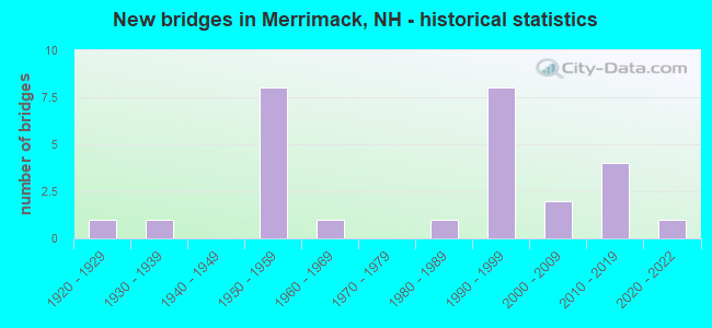
- New bridges - historical statistics
- 11920-1929
- 11930-1939
- 81950-1959
- 11960-1969
- 11980-1989
- 81990-1999
- 22000-2009
- 42010-2019
- 12020-2022
FCC Registered Antenna Towers: 133 (See the full list of FCC Registered Antenna Towers)
FCC Registered Private Land Mobile Towers: 2 (See the full list of FCC Registered Private Land Mobile Towers in Merrimack, NH)
FCC Registered Broadcast Land Mobile Towers: 12 (See the full list of FCC Registered Broadcast Land Mobile Towers)
FCC Registered Microwave Towers: 23 (See the full list of FCC Registered Microwave Towers in this town)
FCC Registered Maritime Coast & Aviation Ground Towers: 1 (See the full list of FCC Registered Maritime Coast & Aviation Ground Towers)
FCC Registered Amateur Radio Licenses: 298 (See the full list of FCC Registered Amateur Radio Licenses in Merrimack)
FAA Registered Aircraft: 24 (See the full list of FAA Registered Aircraft in Merrimack)
2003 - 2018 National Fire Incident Reporting System (NFIRS) incidents
- Fire incident types reported to NFIRS in Merrimack, NH
- 47746.5%Structure Fires
- 34934.0%Outside Fires
- 17116.7%Mobile Property/Vehicle Fires
- 282.7%Other
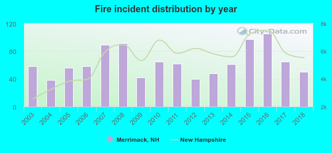 Based on the data from the years 2003 - 2018 the average number of fire incidents per year is 64. The highest number of reported fire incidents - 105 took place in 2016, and the least - 38 in 2004. The data has a dropping trend.
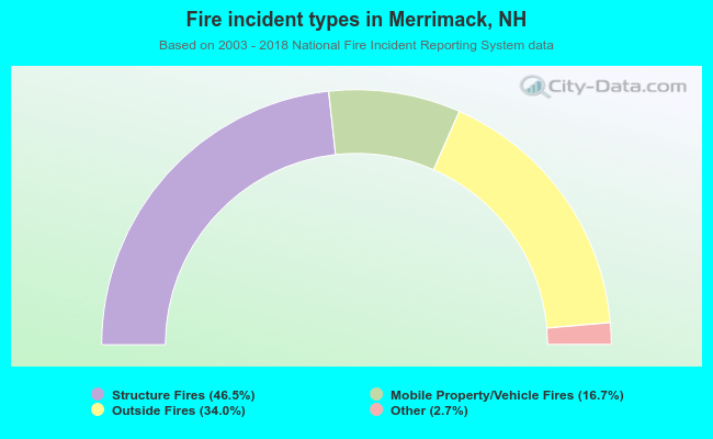 When looking into fire subcategories, the most incidents belonged to: Structure Fires (46.5%), and Outside Fires (34.0%).
Fire-safe hotels and motels in Merrimack, New Hampshire:
- Holiday Inn Express & Suites, 4 Amherst Rd, Merrimack, New Hampshire 03054 , Phone: (603) 429-3600, Fax: (603) 429-3610
- Hawthorn Suites By Wyndham, 246 Daniel Webster Hwy, Merrimack, New Hampshire 03054 , Phone: (603) 424-8100, Fax: (603) 913-2929

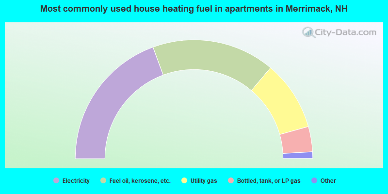
- 39.1%Fuel oil, kerosene, etc.
- 31.2%Utility gas
- 20.1%Bottled, tank, or LP gas
- 6.8%Electricity
- 1.8%Wood
- 0.7%Other fuel
- 0.3%Coal or coke
- 38.8%Electricity
- 33.5%Fuel oil, kerosene, etc.
- 19.0%Utility gas
- 6.9%Bottled, tank, or LP gas
- 1.2%Other fuel
- 0.6%Wood
Merrimack compared to New Hampshire state average:
- Unemployed percentage significantly below state average.
- Black race population percentage below state average.
- Hispanic race population percentage below state average.
- Renting percentage significantly below state average.
- Length of stay since moving in significantly above state average.
- Number of rooms per house significantly below state average.
- House age significantly below state average.
Merrimack on our top lists:
- #14 on the list of "Top 101 cities with largest percentage of males in industries: radio, tv, and computer stores (population 5,000+)"
- #20 on the list of "Top 101 cities with largest percentage of males in industries: computer and electronic products (population 5,000+)"
- #30 on the list of "Top 101 cities with largest percentage of females in occupations: computer specialists (population 5,000+)"
- #32 on the list of "Top 101 cities with largest percentage of females in industries: computer and electronic products (population 5,000+)"
- #35 on the list of "Top 101 cities with largest percentage of males in occupations: computer specialists (population 5,000+)"
- #41 on the list of "Top 101 cities with largest percentage of males in occupations: air transportation workers (population 5,000+)"
- #46 on the list of "Top 101 cities with largest percentage of females in industries: furniture and home furnishings, and household appliance stores (population 5,000+)"
- #58 on the list of "Top 101 cities with largest percentage of females in industries: sporting goods, camera, and hobby and toy stores (population 5,000+)"
- #61 on the list of "Top 101 cities with largest percentage of males in occupations: engineers (population 5,000+)"
- #62 on the list of "Top 101 cities with largest percentage of females in industries: paper and paper products merchant wholesalers (population 5,000+)"
- #67 on the list of "Top 101 cities with largest percentage of males in occupations: business operations specialists (population 5,000+)"
- #79 on the list of "Top 101 cities with largest percentage of females in occupations: air transportation workers (population 5,000+)"
- #84 on the list of "Top 101 cities with largest percentage of males in industries: beverage and tobacco products (population 5,000+)"
- #97 on the list of "Top 101 cities with largest percentage of males in industries: professional and commercial equipment and supplies merchant wholesalers (population 5,000+)"
- #97 on the list of "Top 101 cities with largest percentage of females in industries: recyclable material merchant wholesalers (population 5,000+)"
- #6 on the list of "Top 101 counties with the lowest Particulate Matter (PM10) Annual air pollution readings in 2012 (µg/m3)"
- #12 on the list of "Top 101 counties with the lowest Particulate Matter (PM2.5) Annual air pollution readings in 2012 (µg/m3)"
- #15 on the list of "Top 101 counties with the lowest number of infant deaths per 1000 residents 2007-2013 (pop. 50,000+)"
- #24 on the list of "Top 101 counties with the largest decrease in the number of infant deaths per 1000 residents 2000-2006 to 2007-2013 (pop. 50,000+)"
- #44 on the list of "Top 101 counties with the lowest Nitrogen Dioxide air pollution readings in 2012 (ppm)"

|
|
Total of 1009 patent applications in 2008-2024.