Lummi Island, Washington
Submit your own pictures of this place and show them to the world
- OSM Map
- General Map
- Google Map
- MSN Map

| Males: 459 | |
| Females: 485 |
| Median resident age: | 47.4 years |
| Washington median age: | 35.3 years |
Zip code: 98262
| Lummi Island: | $83,723 |
| WA: | $91,306 |
Estimated per capita income in 2022: $61,325 (it was $27,537 in 2000)
Lummi Island CCD income, earnings, and wages data
Estimated median house or condo value in 2022: $807,900 (it was $200,900 in 2000)
| Lummi Island: | $807,900 |
| WA: | $569,500 |
Mean prices in 2022: all housing units: $618,668; detached houses: $673,947; townhouses or other attached units: $482,237; in 2-unit structures: $597,815; in 3-to-4-unit structures: $424,563; in 5-or-more-unit structures: $322,462; mobile homes: $232,843; occupied boats, rvs, vans, etc.: $243,510
Detailed information about poverty and poor residents in Lummi Island, WA


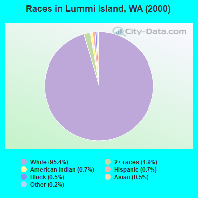
- 78495.4%White alone
- 161.9%Two or more races
- 60.7%American Indian alone
- 60.7%Hispanic
- 40.5%Black alone
- 40.5%Asian alone
- 20.2%Other race alone
Races in Lummi Island detailed stats: ancestries, foreign born residents, place of birth
 Recent articles from our blog. Our writers, many of them Ph.D. graduates or candidates, create easy-to-read articles on a wide variety of topics.
Current Local Time: PST time zone
Elevation: 100 feet
Land area: 9.26 square miles.
Population density: 102 people per square mile (very low).

| Lummi Island CCD: | 1.0% ($2,061) |
| Washington: | 1.2% ($1,915) |
Nearest city with pop. 50,000+: Bellingham, WA  (9.0 miles , pop. 67,171).
Nearest city with pop. 200,000+: Seattle, WA (74.8 miles , pop. 563,374).
Nearest city with pop. 1,000,000+: Los Angeles, CA (1033.5 miles , pop. 3,694,820).
Nearest cities:
), ), Latitude: 48.69 N, Longitude: 122.65 W
Area code commonly used in this area: 360

| Here: | 5.1% |
| Washington: | 4.6% |
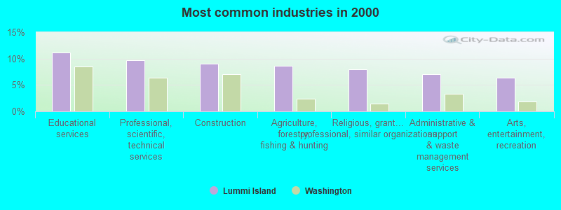
- Educational services (11.1%)
- Professional, scientific, technical services (9.7%)
- Construction (9.0%)
- Agriculture, forestry, fishing & hunting (8.6%)
- Religious, grantmaking, civic, professional, similar organizations (7.9%)
- Administrative & support & waste management services (7.0%)
- Arts, entertainment, recreation (6.3%)
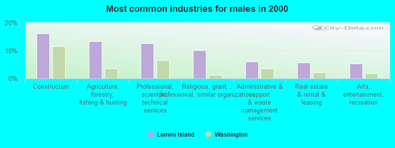
- Construction (16.1%)
- Agriculture, forestry, fishing & hunting (13.3%)
- Professional, scientific, technical services (12.5%)
- Religious, grantmaking, civic, professional, similar organizations (10.1%)
- Administrative & support & waste management services (6.0%)
- Real estate & rental & leasing (5.6%)
- Arts, entertainment, recreation (5.2%)
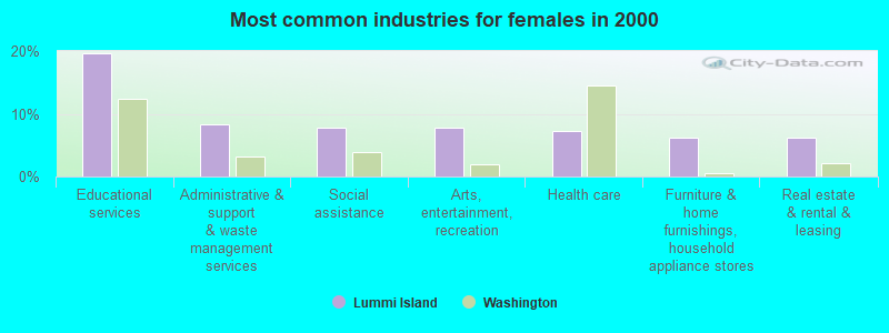
- Educational services (19.6%)
- Administrative & support & waste management services (8.2%)
- Social assistance (7.7%)
- Arts, entertainment, recreation (7.7%)
- Health care (7.2%)
- Furniture & home furnishings, household appliance stores (6.2%)
- Real estate & rental & leasing (6.2%)
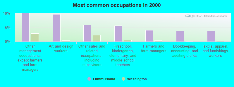
- Other management occupations, except farmers and farm managers (10.0%)
- Art and design workers (9.7%)
- Other sales and related occupations, including supervisors (5.9%)
- Preschool, kindergarten, elementary, and middle school teachers (5.7%)
- Farmers and farm managers (4.1%)
- Bookkeeping, accounting, and auditing clerks (3.8%)
- Textile, apparel, and furnishings workers (3.8%)
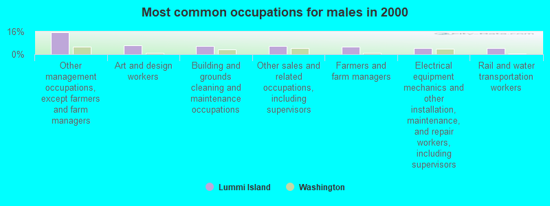
- Other management occupations, except farmers and farm managers (15.3%)
- Art and design workers (6.5%)
- Building and grounds cleaning and maintenance occupations (5.6%)
- Other sales and related occupations, including supervisors (5.6%)
- Farmers and farm managers (5.2%)
- Electrical equipment mechanics and other installation, maintenance, and repair workers, including supervisors (4.4%)
- Rail and water transportation workers (4.4%)
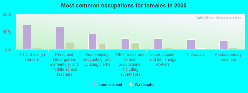
- Art and design workers (13.9%)
- Preschool, kindergarten, elementary, and middle school teachers (12.9%)
- Bookkeeping, accounting, and auditing clerks (8.8%)
- Other sales and related occupations, including supervisors (6.2%)
- Textile, apparel, and furnishings workers (6.2%)
- Therapists (5.7%)
- Postsecondary teachers (5.2%)
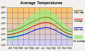
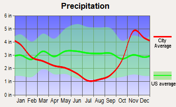
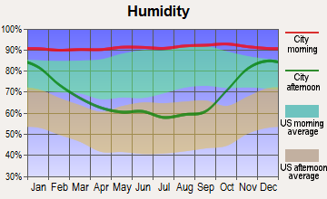
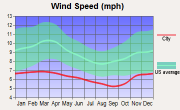
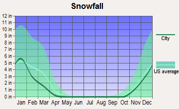
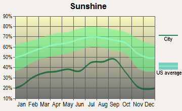
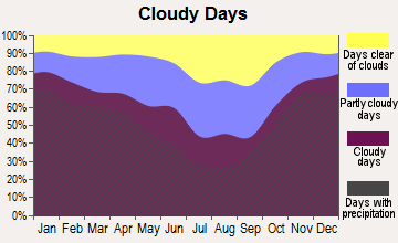
Average climate in Lummi Island, Washington
Based on data reported by over 4,000 weather stations
(lower is better)
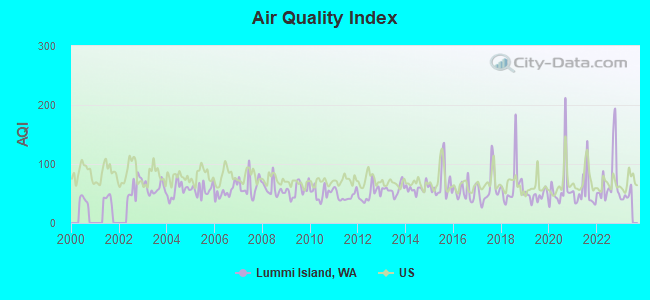
Air Quality Index (AQI) level in 2022 was 74.1. This is about average.
| City: | 74.1 |
| U.S.: | 72.6 |
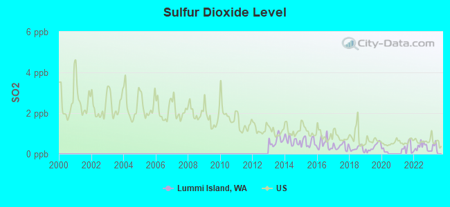
Sulfur Dioxide (SO2) [ppb] level in 2022 was 0.347. This is significantly better than average. Closest monitor was 8.6 miles away from the city center.
| City: | 0.347 |
| U.S.: | 1.515 |
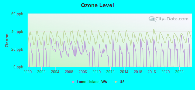
Ozone [ppb] level in 2022 was 24.1. This is better than average. Closest monitor was 11.6 miles away from the city center.
| City: | 24.1 |
| U.S.: | 33.3 |
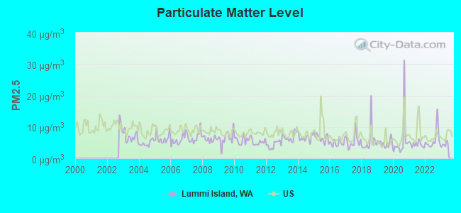
Particulate Matter (PM2.5) [µg/m3] level in 2022 was 5.93. This is better than average. Closest monitor was 10.1 miles away from the city center.
| City: | 5.93 |
| U.S.: | 8.11 |
Earthquake activity:
Lummi Island-area historical earthquake activity is significantly above Washington state average. It is 996% greater than the overall U.S. average.On 4/13/1949 at 19:55:42, a magnitude 7.0 (7.0 UK, Class: Major, Intensity: VIII - XII) earthquake occurred 99.6 miles away from the city center, causing $80,000,000 total damage
On 2/28/2001 at 18:54:32, a magnitude 6.8 (6.8 MD, Depth: 32.2 mi, Class: Strong, Intensity: VII - IX) earthquake occurred 106.4 miles away from Lummi Island center
On 2/28/2001 at 18:54:32, a magnitude 6.8 (6.5 MB, 6.6 MS, 6.8 MW) earthquake occurred 110.5 miles away from the city center, causing $2,000,000,000 total damage and $305,000,000 insured losses
On 4/29/1965 at 15:28:43, a magnitude 6.6 (6.6 UK) earthquake occurred 95.8 miles away from Lummi Island center, causing $28,000,000 total damage
On 7/3/1999 at 01:43:54, a magnitude 5.8 (5.4 MB, 5.5 MS, 5.8 MW, 5.3 ME, Depth: 25.2 mi, Class: Moderate, Intensity: VI - VII) earthquake occurred 115.8 miles away from Lummi Island center
On 5/3/1996 at 04:04:22, a magnitude 5.5 (5.2 MB, 5.3 MD, 5.5 ML, Depth: 2.5 mi) earthquake occurred 72.1 miles away from the city center
Magnitude types: body-wave magnitude (MB), duration magnitude (MD), energy magnitude (ME), local magnitude (ML), surface-wave magnitude (MS), moment magnitude (MW)
Natural disasters:
The number of natural disasters in Whatcom County (21) is greater than the US average (15).Major Disasters (Presidential) Declared: 17
Emergencies Declared: 1
Causes of natural disasters: Floods: 13, Storms: 10, Mudslides: 7, Winter Storms: 5, Landslides: 4, Winds: 3, Snows: 2, Earthquake: 1, Fire: 1, Heavy Rain: 1, Hurricane: 1, Tornado: 1, Volcanic Eruption: 1, Other: 1 (Note: some incidents may be assigned to more than one category).
Hospitals and medical centers near Lummi Island:
- SIGNATURE HOME HEALTH (Home Health Center, about 7 miles away; BELLINGHAM, WA)
- MT BAKER CARE CENTER (Nursing Home, about 8 miles away; BELLINGHAM, WA)
- SEHOME PARK CARE CENTER (Nursing Home, about 9 miles away; BELLINGHAM, WA)
- SAINT FRANCIS CONVALESCENT HOME (Nursing Home, about 9 miles away; BELLINGHAM, WA)
- HIGHLAND CARE CENTER LLC (Nursing Home, about 9 miles away; BELLINGHAM, WA)
- WHATCOM HOSPICE (Hospital, about 9 miles away; BELLINGHAM, WA)
- ST LUKES GENERAL HOSPITAL (Hospital, about 9 miles away; BELLINGHAM, WA)
Colleges/universities with over 2000 students nearest to Lummi Island:
- Western Washington University (about 9 miles; Bellingham, WA; Full-time enrollment: 13,875)
- Whatcom Community College (about 11 miles; Bellingham, WA; FT enrollment: 3,265)
- Skagit Valley College (about 24 miles; Mount Vernon, WA; FT enrollment: 3,803)
- Everett Community College (about 52 miles; Everett, WA; FT enrollment: 5,818)
- Peninsula College (about 54 miles; Port Angeles, WA; FT enrollment: 2,012)
- Edmonds Community College (about 62 miles; Lynnwood, WA; FT enrollment: 7,271)
- Shoreline Community College (about 67 miles; Shoreline, WA; FT enrollment: 5,026)
Public elementary/middle school in Lummi Island:
- BEACH ELEM (Location: 3786 CENTERVIEW ROAD, Grades: KG-6)
Points of interest:
Notable locations in Lummi Island: Loganita Lodge (A), Lummi Island Ferry Landing (B), The Willows (C), Echo Lodge (D), Whatcom County Fire District 11 Lummi Island (E), Lummi Island Library (F). Display/hide their locations on the map
Church in Lummi Island: Lummi Island Congregational Church (A). Display/hide its location on the map
Reservoirs: Baker Reservoir (A), Holiday Lake (B). Display/hide their locations on the map
| This place: | 2.0 people |
| Washington: | 2.5 people |
| This place: | 57.4% |
| Whole state: | 64.4% |
| This place: | 6.9% |
| Whole state: | 7.7% |
Likely homosexual households (counted as self-reported same-sex unmarried-partner households)
- Lesbian couples: 0.6% of all households
- Gay men: 0.8% of all households
| This place: | 11.6% |
| Whole state: | 10.6% |
| This place: | 3.5% |
| Whole state: | 4.6% |
For population 15 years and over in Lummi Island:
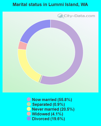
- Never married: 20.5%
- Now married: 55.8%
- Separated: 0.9%
- Widowed: 4.1%
- Divorced: 19.6%
For population 25 years and over in Lummi Island:
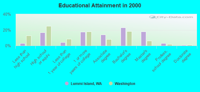
- High school or higher: 96.7%
- Bachelor's degree or higher: 44.5%
- Graduate or professional degree: 21.5%
- Unemployed: 2.4%
- Mean travel time to work (commute): 37.4 minutes
| Here: | 8.5 |
| Washington average: | 11.3 |
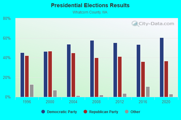

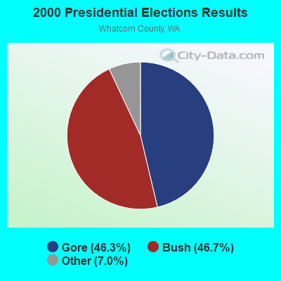

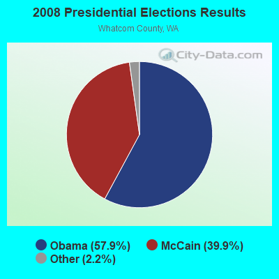
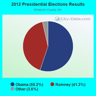
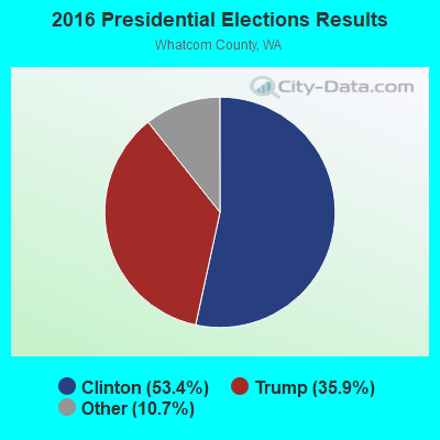
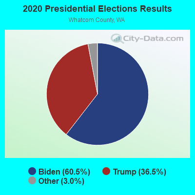
Graphs represent county-level data. Detailed 2008 Election Results
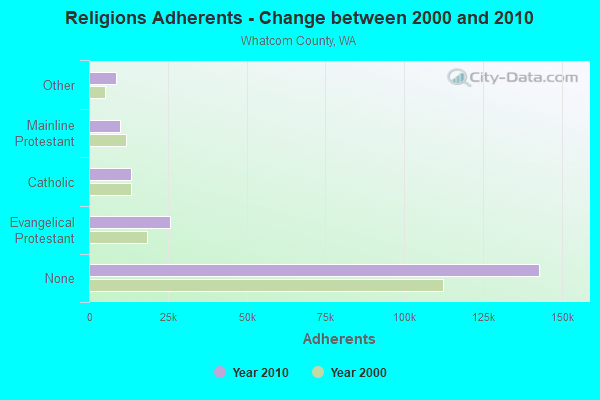
Religion statistics for Lummi Island, WA (based on Whatcom County data)
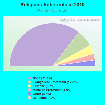
| Religion | Adherents | Congregations |
|---|---|---|
| Evangelical Protestant | 25,842 | 105 |
| Catholic | 13,397 | 6 |
| Mainline Protestant | 9,859 | 39 |
| Other | 8,714 | 33 |
| Orthodox | 370 | 2 |
| None | 142,958 | - |
Food Environment Statistics:
| Whatcom County: | 1.77 / 10,000 pop. |
| Washington: | 2.06 / 10,000 pop. |
| Whatcom County: | 0.16 / 10,000 pop. |
| State: | 0.19 / 10,000 pop. |
| This county: | 0.83 / 10,000 pop. |
| Washington: | 1.18 / 10,000 pop. |
| This county: | 3.80 / 10,000 pop. |
| Washington: | 2.67 / 10,000 pop. |
| Here: | 9.57 / 10,000 pop. |
| Washington: | 8.26 / 10,000 pop. |
| Whatcom County: | 6.1% |
| Washington: | 7.7% |
| This county: | 23.1% |
| Washington: | 25.7% |
| This county: | 14.4% |
| State: | 13.9% |
Strongest AM radio stations in Lummi Island:
- KRPI (1550 AM; 50 kW; FERNDALE, WA; Owner: BBC BROADCASTING, INC.)
- KARI (550 AM; 25 kW; BLAINE, WA; Owner: WAY BROADCASTING, INC.)
- KGMI (790 AM; 5 kW; BELLINGHAM, WA)
- KPUG (1170 AM; 10 kW; BELLINGHAM, WA; Owner: SAGA BROADCASTING, LLC)
- KAPS (660 AM; 10 kW; MOUNT VERNON, WA; Owner: VALLEY BROADCASTERS, INC.)
- KRKO (1380 AM; 50 kW; EVERETT, WA; Owner: S-R BROADCASTING, CO.)
- KIXI (880 AM; 50 kW; MERCER ISLAND/SEATTL, WA; Owner: BELLEVUE RADIO, INC.)
- KBAI (930 AM; 1 kW; BELLINGHAM, WA; Owner: SAGA BROADCASTING, LLC)
- KIRO (710 AM; 50 kW; SEATTLE, WA; Owner: ENTERCOM SEATTLE LICENSE, LLC)
- KGNW (820 AM; 50 kW; BURIEN-SEATTLE, WA; Owner: INSPIRATION MEDIA, INC.)
- KTTH (770 AM; 50 kW; SEATTLE, WA; Owner: ENTERCOM SEATTLE LICENSE, LLC)
- KKOL (1300 AM; 50 kW; SEATTLE, WA; Owner: INSPIRATION MEDIA, INC.)
- KBRC (1430 AM; 5 kW; MOUNT VERNON, WA; Owner: JIM AND ANN KEANE)
Strongest FM radio stations in Lummi Island:
- KISM (92.9 FM; BELLINGHAM, WA; Owner: SAGA BROADCASTING, LLC)
- KAFE (104.3 FM; BELLINGHAM, WA; Owner: SAGA BROADCASTING, LLC)
- KWPZ (106.5 FM; LYNDEN, WA; Owner: CRISTA MINISTRIES, INC.)
- K201FH (88.1 FM; BELLINGHAM, WA; Owner: CALVARY CHAPEL OF TWIN FALLS, INC.)
- K210CN (89.9 FM; BELLINGHAM, WA; Owner: CALVARY CHAPEL OF TWIN FALLS, INC.)
- KUGS (89.3 FM; BELLINGHAM, WA; Owner: WESTERN WASHINGTON UNIVERSITY)
- KSVR (91.7 FM; MOUNT VERNON, WA; Owner: BOARD OF TRUSTEES OF SKAGIT VALLEY COLLEGE)
- K206CU (89.1 FM; MOUNT VERNON, WA; Owner: CALVARY CHAPEL OF TWIN FALLS, INC.)
- KZAZ (91.7 FM; BELLINGHAM, WA; Owner: WASHINGTON STATE UNIVERSITY)
TV broadcast stations around Lummi Island:
- KBCB (Channel 24; BELLINGHAM, WA; Owner: WORLD TELEVISION OF WASHINGTON, LLC.)
- KVOS-TV (Channel 12; BELLINGHAM, WA; Owner: ACKERLEY MEDIA GROUP, INC.)
Lummi Island fatal accident list:
FCC Registered Cell Phone Towers:
1- 3595 Sunrise Rd (11356) (Lat: 48.690222 Lon: -122.667444), Type: Ltower, Structure height: 45.7 m, Overall height: 50.9 m, Call Sign: KNKA572
Assigned Frequencies: 869.040 MHz, 869.040 MHz, 869.040 MHz, 824.040 MHz, 824.040 MHz, 824.040 MHz, 890.010 MHz, 890.010 MHz, 890.010 MHz, 845.010 MHz, 845.010 MHz, 845.010 MHzGrant Date: 10/10/2018, Expiration Date: 10/01/2028, Certifier: Michael P GogginRegistrant: At&t Services, Inc., 208 S Akard St, 20f, Dallas, TX 75202, Phone: (855) 699-7073, Fax: (214) 746-6410, Email:
FCC Registered Broadcast Land Mobile Towers:
1- Lummi Water Tank, Tank (Lat: 48.681444 Lon: -122.642806), Type: Tank, Structure height: 6.1 m, Overall height: 8 m, Call Sign: KOK851,
Assigned Frequencies: 154.340 MHz, 154.430 MHz, Grant Date: 01/04/2024, Expiration Date: 03/02/2034, Registrant: City Of Bellingham, 2221 Pacific St, Bellingham, WA 98229, Phone: (360) 778-7822, Fax: (360) 778-7701, Email:
FCC Registered Microwave Towers:
6 (See the full list of FCC Registered Microwave Towers in this town)FCC Registered Paging Towers:
3 (See the full list of FCC Registered Paging Towers)FCC Registered Amateur Radio Licenses:
34 (See the full list of FCC Registered Amateur Radio Licenses in Lummi Island)FAA Registered Aircraft:
1- Aircraft: FOWLER KELLY M GERE SPORT (Category: Land, Weight: Up to 12,499 Pounds), Engine: SUBARU ALL MDLS A/B (400 HP) (Reciprocating)
N-Number: 9033Y, N9033Y, N-9033Y, Serial Number: KF001, Year manufactured: 2004, Airworthiness Date: 03/11/2014, Certificate Issue Date: 04/28/2014
Registrant (Individual): Lee E Mosley, 3710 Legoe Bay Rd, Lummi Island, WA 98262
2002 - 2018 National Fire Incident Reporting System (NFIRS) incidents
- Fire incident types reported to NFIRS in Lummi Island, WA
- 7956.8%Outside Fires
- 3424.5%Structure Fires
- 1510.8%Mobile Property/Vehicle Fires
- 117.9%Other
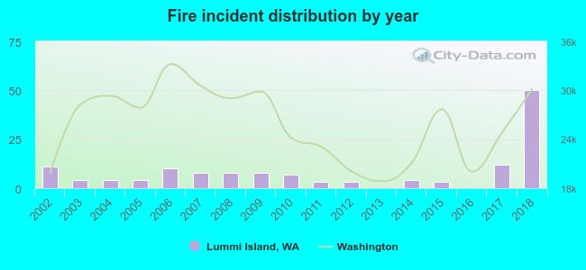 According to the data from the years 2002 - 2018 the average number of fire incidents per year is 8. The highest number of reported fires - 50 took place in 2018, and the least - 0 in 2013. The data has an increasing trend.
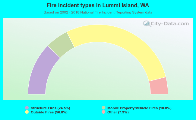 When looking into fire subcategories, the most reports belonged to: Outside Fires (56.8%), and Structure Fires (24.5%).
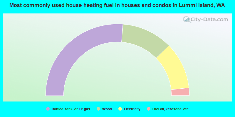
- 52.4%Bottled, tank, or LP gas
- 23.0%Wood
- 21.1%Electricity
- 3.5%Fuel oil, kerosene, etc.
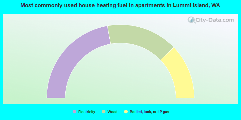
- 44.3%Electricity
- 31.4%Wood
- 24.3%Bottled, tank, or LP gas
Lummi Island compared to Washington state average:
- Unemployed percentage significantly below state average.
- Black race population percentage significantly below state average.
- Hispanic race population percentage significantly below state average.
- Median age significantly above state average.
- Foreign-born population percentage significantly below state average.
- Renting percentage below state average.
- Length of stay since moving in significantly above state average.
- Number of rooms per house significantly below state average.
- House age significantly below state average.
- Percentage of population with a bachelor's degree or higher above state average.
Lummi Island on our top lists:
- #44 on the list of "Top 101 cities with the most cars per house, population 500+"
- #7 on the list of "Top 101 counties with the lowest Ozone (1-hour) air pollution readings in 2012 (ppm)"
- #8 on the list of "Top 101 counties with the lowest Particulate Matter (PM2.5) Annual air pollution readings in 2012 (µg/m3)"
- #42 on the list of "Top 101 counties with highest percentage of residents voting for 3rd party candidates in the 2012 Presidential Election (pop. 50,000+)"

|
Total of 10 patent applications in 2008-2024.