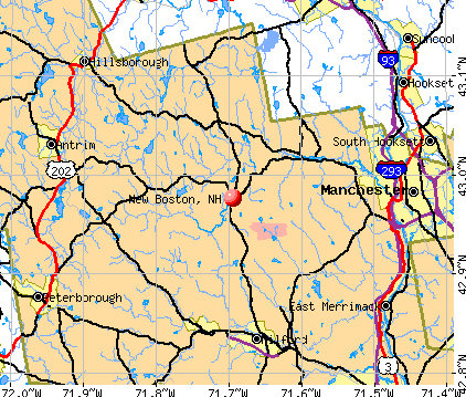
New Boston, New Hampshire
New Boston: Old Creamery and Community Theater
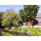
New Boston: Piscataquog River, New Boston
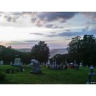
New Boston: View of New Boston from Cemetary Hill, July 4th, 2011-
New Boston: New Boston Grange August 2012
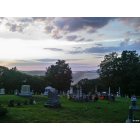
New Boston: Fourth of July, 2011- View of Valley from Cemetary Hill... just before the fireworks
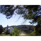
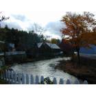
New Boston: New Boston Playfield and Town in Background.
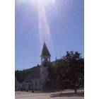
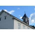
New Boston: New Boston Church w/sunbeam.
- add
your
Submit your own pictures of this town and show them to the world
- OSM Map
- General Map
- Google Map
- MSN Map
Population change since 2000: +28.6%
| Males: 2,671 | |
| Females: 2,650 |
| Median resident age: | 39.9 years |
| New Hampshire median age: | 43.9 years |
Zip codes: 03070.
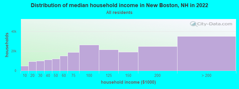
| New Boston: | $119,862 |
| NH: | $89,992 |
Estimated per capita income in 2022: $52,825 (it was $26,488 in 2000)
New Boston town income, earnings, and wages data
Estimated median house or condo value in 2022: $445,092 (it was $148,000 in 2000)
| New Boston: | $445,092 |
| NH: | $384,700 |
Mean prices in 2022: all housing units: $411,252; detached houses: $441,251; townhouses or other attached units: $283,002; in 2-unit structures: $347,377; in 3-to-4-unit structures: $666,663; in 5-or-more-unit structures: $275,798; mobile homes: $132,093
Detailed information about poverty and poor residents in New Boston, NH


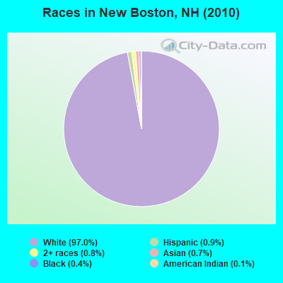
- 5,16197.0%White alone
- 490.9%Hispanic
- 440.8%Two or more races
- 380.7%Asian alone
- 210.4%Black alone
- 70.1%American Indian alone
- 10.02%Other race alone
Races in New Boston detailed stats: ancestries, foreign born residents, place of birth
According to our research of New Hampshire and other state lists, there were 4 registered sex offenders living in New Boston, New Hampshire as of May 17, 2024.
The ratio of all residents to sex offenders in New Boston is 1,330 to 1.
The ratio of registered sex offenders to all residents in this city is much lower than the state average.
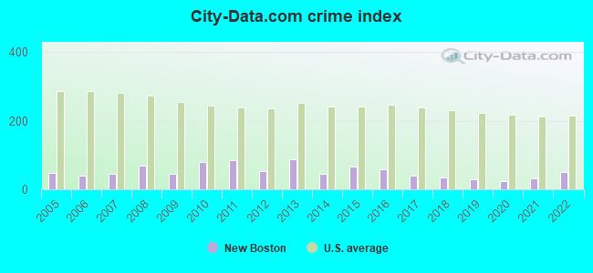
Type |
2009 |
2010 |
2011 |
2012 |
2013 |
2014 |
2015 |
2016 |
2017 |
2018 |
2019 |
2020 |
2021 |
2022 |
|---|---|---|---|---|---|---|---|---|---|---|---|---|---|---|
| Murders (per 100,000) | 0 (0.0) | 0 (0.0) | 0 (0.0) | 0 (0.0) | 0 (0.0) | 0 (0.0) | 0 (0.0) | 0 (0.0) | 0 (0.0) | 0 (0.0) | 0 (0.0) | 0 (0.0) | 0 (0.0) | 0 (0.0) |
| Rapes (per 100,000) | 0 (0.0) | 1 (18.8) | 2 (37.5) | 0 (0.0) | 4 (74.3) | 0 (0.0) | 0 (0.0) | 2 (36.2) | 1 (17.8) | 1 (17.5) | 1 (17.1) | 1 (16.8) | 1 (16.7) | 3 (48.3) |
| Robberies (per 100,000) | 0 (0.0) | 0 (0.0) | 0 (0.0) | 0 (0.0) | 0 (0.0) | 0 (0.0) | 0 (0.0) | 0 (0.0) | 0 (0.0) | 0 (0.0) | 0 (0.0) | 0 (0.0) | 0 (0.0) | 0 (0.0) |
| Assaults (per 100,000) | 2 (38.6) | 3 (56.4) | 0 (0.0) | 2 (37.4) | 1 (18.6) | 3 (55.2) | 0 (0.0) | 3 (54.3) | 2 (35.6) | 2 (35.1) | 1 (17.1) | 1 (16.8) | 3 (50.0) | 1 (16.1) |
| Burglaries (per 100,000) | 11 (212.1) | 19 (357.1) | 20 (375.4) | 20 (374.2) | 5 (92.9) | 12 (220.9) | 34 (620.0) | 2 (36.2) | 3 (53.4) | 3 (52.6) | 1 (17.1) | 1 (16.8) | 0 (0.0) | 0 (0.0) |
| Thefts (per 100,000) | 20 (385.7) | 32 (601.4) | 36 (675.7) | 24 (449.0) | 23 (427.2) | 23 (423.4) | 28 (510.6) | 21 (380.2) | 15 (267.0) | 11 (192.8) | 13 (222.0) | 8 (134.1) | 7 (116.6) | 11 (177.0) |
| Auto thefts (per 100,000) | 4 (77.1) | 3 (56.4) | 1 (18.8) | 1 (18.7) | 1 (18.6) | 1 (18.4) | 2 (36.5) | 0 (0.0) | 2 (35.6) | 1 (17.5) | 1 (17.1) | 1 (16.8) | 2 (33.3) | 1 (16.1) |
| Arson (per 100,000) | 0 (0.0) | 0 (0.0) | 0 (0.0) | 2 (37.4) | 1 (18.6) | 1 (18.4) | 0 (0.0) | 0 (0.0) | 0 (0.0) | 0 (0.0) | 0 (0.0) | 0 (0.0) | 0 (0.0) | 0 (0.0) |
| City-Data.com crime index | 44.2 | 79.9 | 84.8 | 53.1 | 88.2 | 44.9 | 66.7 | 57.6 | 38.6 | 33.8 | 28.5 | 24.6 | 30.6 | 50.2 |
The City-Data.com crime index weighs serious crimes and violent crimes more heavily. Higher means more crime, U.S. average is 246.1. It adjusts for the number of visitors and daily workers commuting into cities.
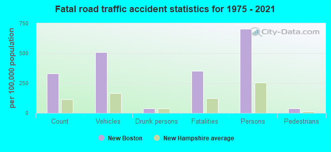
Crime rate in New Boston detailed stats: murders, rapes, robberies, assaults, burglaries, thefts, arson
Full-time law enforcement employees in 2021, including police officers: 8 (7 officers - 5 male; 2 female).
| Officers per 1,000 residents here: | 1.17 |
| New Hampshire average: | 2.14 |
 Recent articles from our blog. Our writers, many of them Ph.D. graduates or candidates, create easy-to-read articles on a wide variety of topics.

 | talk to me about the new boston area (19 replies) |
| Quiet town in Southern New Hampshire (7 replies) |
| Seeking info about New Boston, NH (10 replies) |
| Relocation suggestions (30 replies) |
| Manchester Suburbs (15 replies) |
| Relocation to NH from South Korea (9 replies) |
Latest news from New Boston, NH collected exclusively by city-data.com from local newspapers, TV, and radio stations
Ancestries: Irish (18.8%), English (16.4%), French (13.8%), French Canadian (12.5%), German (9.2%), Italian (7.8%).
Current Local Time: EST time zone
Incorporated in 1763
Elevation: 469 feet
Land area: 42.8 square miles.
Population density: 124 people per square mile (very low).
123 residents are foreign born (1.6% Europe, 0.4% North America, 0.4% Asia, 0.4% Latin America).
| This town: | 3.0% |
| New Hampshire: | 4.4% |
| New Boston town: | 2.3% ($3,342) |
| New Hampshire: | 2.3% ($2,946) |
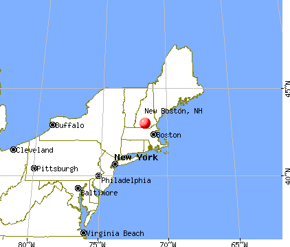
Nearest city with pop. 50,000+: Manchester, NH  (12.3 miles , pop. 107,006).
Nearest city with pop. 200,000+: Boston, MA (54.9 miles , pop. 589,141).
Nearest city with pop. 1,000,000+: Bronx, NY (185.2 miles , pop. 1,332,650).
Nearest cities:
), ), ), )Latitude: 42.98 N, Longitude: 71.69 W
Area code: 603

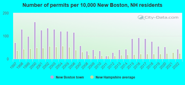
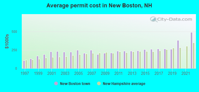
Single-family new house construction building permits:
- 2022: 18 buildings, average cost: $491,600
- 2020: 22 buildings, average cost: $384,200
- 2019: 23 buildings, average cost: $262,400
- 2018: 32 buildings, average cost: $266,000
- 2017: 37 buildings, average cost: $267,800
- 2016: 38 buildings, average cost: $261,800
- 2015: 37 buildings, average cost: $257,200
- 2014: 18 buildings, average cost: $242,200
- 2013: 17 buildings, average cost: $237,900
- 2012: 12 buildings, average cost: $236,600
- 2011: 6 buildings, average cost: $238,300
- 2010: 15 buildings, average cost: $212,300
- 2009: 17 buildings, average cost: $207,400
- 2008: 14 buildings, average cost: $190,400
- 2007: 24 buildings, average cost: $249,000
- 2006: 48 buildings, average cost: $209,900
- 2005: 50 buildings, average cost: $250,000
- 2004: 50 buildings, average cost: $224,000
- 2003: 54 buildings, average cost: $225,100
- 2002: 56 buildings, average cost: $230,500
- 2001: 52 buildings, average cost: $228,900
- 2000: 67 buildings, average cost: $191,100
- 1999: 41 buildings, average cost: $169,000
- 1998: 54 buildings, average cost: $134,000
- 1997: 30 buildings, average cost: $107,900
| Here: | 2.0% |
| New Hampshire: | 2.5% |
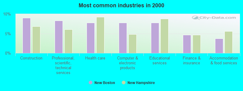
- Construction (9.0%)
- Professional, scientific, technical services (8.3%)
- Health care (7.8%)
- Computer & electronic products (7.8%)
- Educational services (7.7%)
- Finance & insurance (4.6%)
- Accommodation & food services (3.7%)
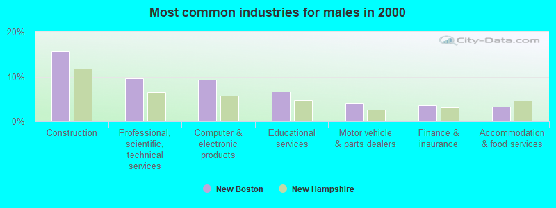
- Construction (15.7%)
- Professional, scientific, technical services (9.7%)
- Computer & electronic products (9.3%)
- Educational services (6.7%)
- Motor vehicle & parts dealers (4.1%)
- Finance & insurance (3.6%)
- Accommodation & food services (3.2%)
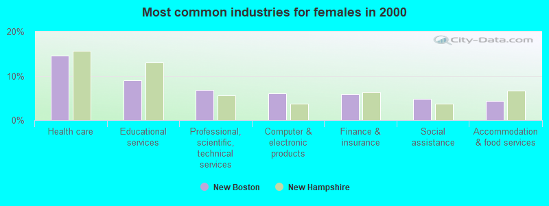
- Health care (14.6%)
- Educational services (8.9%)
- Professional, scientific, technical services (6.8%)
- Computer & electronic products (6.0%)
- Finance & insurance (5.8%)
- Social assistance (4.8%)
- Accommodation & food services (4.3%)
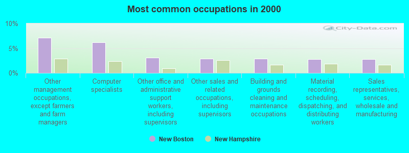
- Other management occupations, except farmers and farm managers (7.2%)
- Computer specialists (6.2%)
- Other office and administrative support workers, including supervisors (3.1%)
- Other sales and related occupations, including supervisors (2.9%)
- Building and grounds cleaning and maintenance occupations (2.8%)
- Material recording, scheduling, dispatching, and distributing workers (2.8%)
- Sales representatives, services, wholesale and manufacturing (2.8%)
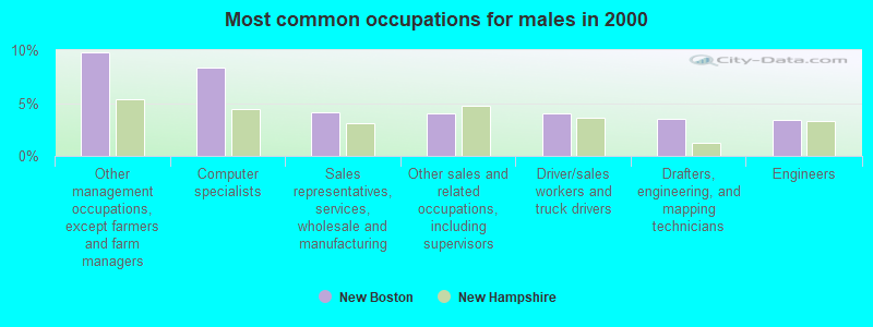
- Other management occupations, except farmers and farm managers (9.8%)
- Computer specialists (8.4%)
- Sales representatives, services, wholesale and manufacturing (4.2%)
- Other sales and related occupations, including supervisors (4.0%)
- Driver/sales workers and truck drivers (4.0%)
- Drafters, engineering, and mapping technicians (3.5%)
- Engineers (3.4%)
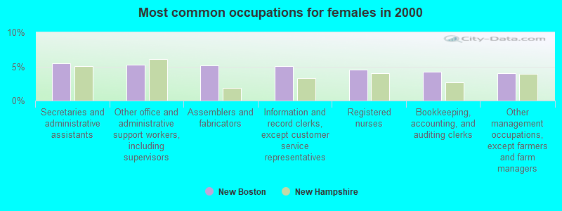
- Secretaries and administrative assistants (5.4%)
- Other office and administrative support workers, including supervisors (5.3%)
- Assemblers and fabricators (5.2%)
- Information and record clerks, except customer service representatives (5.1%)
- Registered nurses (4.5%)
- Bookkeeping, accounting, and auditing clerks (4.2%)
- Other management occupations, except farmers and farm managers (4.0%)
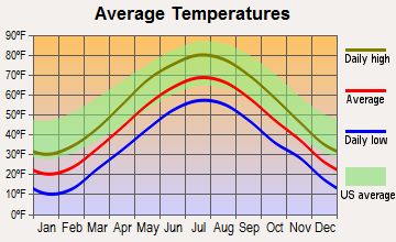
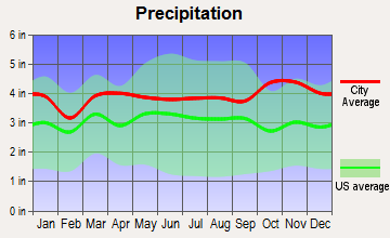
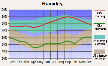
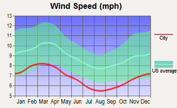
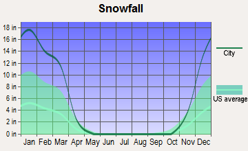
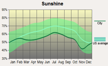
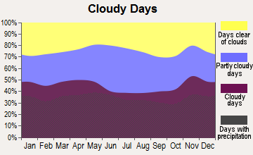
Average climate in New Boston, New Hampshire
Based on data reported by over 4,000 weather stations
(lower is better)
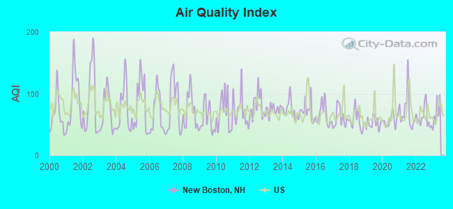
Air Quality Index (AQI) level in 2022 was 60.7. This is about average.
| City: | 60.7 |
| U.S.: | 72.6 |
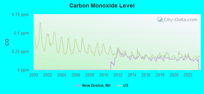
Carbon Monoxide (CO) [ppm] level in 2022 was 0.141. This is significantly better than average. Closest monitor was 11.8 miles away from the city center.
| City: | 0.141 |
| U.S.: | 0.251 |
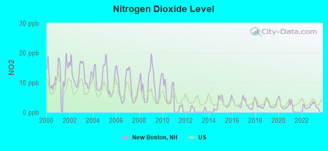
Nitrogen Dioxide (NO2) [ppb] level in 2022 was 2.05. This is significantly better than average. Closest monitor was 11.6 miles away from the city center.
| City: | 2.05 |
| U.S.: | 5.11 |
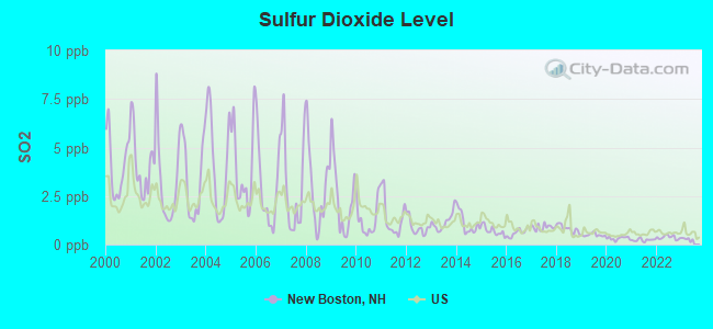
Sulfur Dioxide (SO2) [ppb] level in 2022 was 0.370. This is significantly better than average. Closest monitor was 11.6 miles away from the city center.
| City: | 0.370 |
| U.S.: | 1.515 |
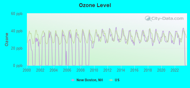
Ozone [ppb] level in 2022 was 33.6. This is about average. Closest monitor was 11.6 miles away from the city center.
| City: | 33.6 |
| U.S.: | 33.3 |
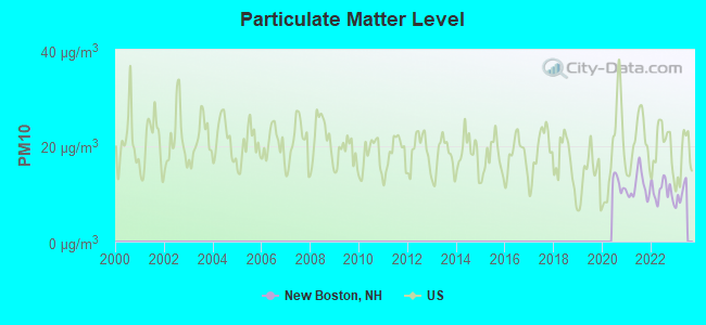
Particulate Matter (PM10) [µg/m3] level in 2022 was 10.6. This is significantly better than average. Closest monitor was 11.1 miles away from the city center.
| City: | 10.6 |
| U.S.: | 19.2 |
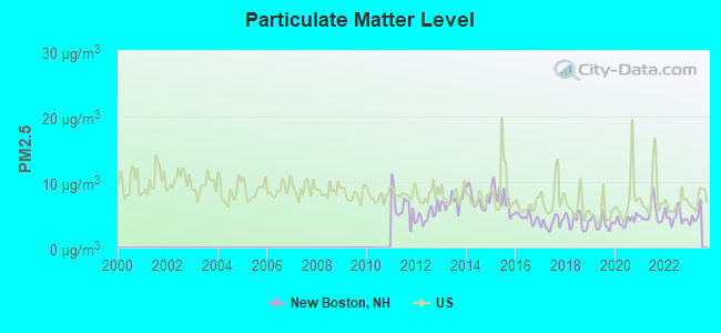
Particulate Matter (PM2.5) [µg/m3] level in 2022 was 4.67. This is significantly better than average. Closest monitor was 11.6 miles away from the city center.
| City: | 4.67 |
| U.S.: | 8.11 |
Tornado activity:
New Boston-area historical tornado activity is above New Hampshire state average. It is 33% smaller than the overall U.S. average.
On 6/9/1953, a category F4 (max. wind speeds 207-260 mph) tornado 42.7 miles away from the New Boston town center killed 90 people and injured 1228 people and caused between $50,000,000 and $500,000,000 in damages.
On 10/3/1970, a category F3 (max. wind speeds 158-206 mph) tornado 29.6 miles away from the town center killed one person and caused between $50,000 and $500,000 in damages.
Earthquake activity:
New Boston-area historical earthquake activity is significantly above New Hampshire state average. It is 71% smaller than the overall U.S. average.On 4/20/2002 at 10:50:47, a magnitude 5.3 (5.3 ML, Depth: 3.0 mi, Class: Moderate, Intensity: VI - VII) earthquake occurred 145.9 miles away from the city center
On 10/7/1983 at 10:18:46, a magnitude 5.3 (5.1 MB, 5.3 LG, 5.1 ML) earthquake occurred 149.0 miles away from New Boston center
On 1/19/1982 at 00:14:42, a magnitude 4.7 (4.5 MB, 4.7 MD, 4.5 LG, Class: Light, Intensity: IV - V) earthquake occurred 36.4 miles away from the city center
On 4/20/2002 at 10:50:47, a magnitude 5.2 (5.2 MB, 4.2 MS, 5.2 MW, 5.0 MW) earthquake occurred 145.3 miles away from the city center
On 10/16/2012 at 23:12:25, a magnitude 4.7 (4.7 ML, Depth: 10.0 mi) earthquake occurred 67.6 miles away from the city center
On 10/2/1994 at 11:27:22, a magnitude 3.7 (3.5 LG, 3.7 LG, Depth: 6.2 mi, Class: Light, Intensity: II - III) earthquake occurred 52.8 miles away from the city center
Magnitude types: regional Lg-wave magnitude (LG), body-wave magnitude (MB), duration magnitude (MD), local magnitude (ML), surface-wave magnitude (MS), moment magnitude (MW)
Natural disasters:
The number of natural disasters in Hillsborough County (27) is a lot greater than the US average (15).Major Disasters (Presidential) Declared: 17
Emergencies Declared: 10
Causes of natural disasters: Storms: 13, Floods: 11, Winter Storms: 5, Snowstorms: 4, Hurricanes: 3, Snows: 3, Blizzard: 1, Ice Storm: 1, Snowfall: 1, Wind: 1 (Note: some incidents may be assigned to more than one category).
Hospitals and medical centers near New Boston:
- BEL AIR NURSING HOME (Nursing Home, about 8 miles away; GOFFSTOWN, NH)
- HILLSBOROUGH COUNTY NURSING HOME (Nursing Home, about 9 miles away; GOFFSTOWN, NH)
- ST JOSEPH HOME AND HOSPICE CARE (Home Health Center, about 10 miles away; MILFORD, NH)
- LAUREL CENTER (Nursing Home, about 10 miles away; BEDFORD, NH)
- CRESTWOOD CARE AND REHABILITATION CENTER (Nursing Home, about 11 miles away; MILFORD, NH)
- ELM'S NURSING AND REHAB CENTER (THE) (Nursing Home, about 11 miles away; MILFORD, NH)
- BEDFORD HILLS CARE AND REHABILITATION CENTER (Nursing Home, about 11 miles away; BEDFORD, NH)
Airports and heliports located in New Boston:
- Huff Memorial Airport (NH60) (Runways: 1)
- A And K Heliport (28NH)
- Austin's Landing Heliport (NH46)
- Lorden Ii Heliport (19NH)
Colleges/universities with over 2000 students nearest to New Boston:
- Saint Anselm College (about 10 miles; Manchester, NH; Full-time enrollment: 2,059)
- Mount Washington College (about 12 miles; Manchester, NH; FT enrollment: 2,187)
- Southern New Hampshire University (about 13 miles; Manchester, NH; FT enrollment: 16,552)
- NHTI-Concord's Community College (about 19 miles; Concord, NH; FT enrollment: 2,865)
- Franklin Pierce University (about 23 miles; Rindge, NH; FT enrollment: 2,139)
- Fitchburg State University (about 28 miles; Fitchburg, MA; FT enrollment: 5,010)
- University of Massachusetts-Lowell (about 30 miles; Lowell, MA; FT enrollment: 12,341)
Public elementary/middle school in New Boston:
- NEW BOSTON CENTRAL SCHOOL (Students: 524, Location: 15 CENTRAL SCHOOL RD., Grades: PK-6)
Points of interest:
Notable locations in New Boston: Hillsborough County Agricultural Fairgrounds (A), New Boston Fire Department (B). Display/hide their locations on the map
Lakes, reservoirs, and swamps: Bailey Pond (A), Beard Pond (B), Beaver Dam Pond (C), Colby Pond (D), Dodge Pond (E), Campbell Pond (F), Maddening Ponds (G), Mayberry Pond (H). Display/hide their locations on the map
Streams, rivers, and creeks: Peacock Brook (A), Middle Branch Piscataquog River (B), Meadow Brook (C), Lords Brook (D), Currier Brook (E), Cold Brook (F), Buxton Brook (G). Display/hide their locations on the map
Birthplace of: Andy Comeau - Actor.
Drinking water stations with addresses in New Boston that have no violations reported:
- WHIPPLE FREE LIBRARY (Population served: 50, Primary Water Source Type: Groundwater)
| This town: | 2.8 people |
| New Hampshire: | 2.5 people |
| This town: | 78.7% |
| Whole state: | 66.3% |
| This town: | 8.2% |
| Whole state: | 8.3% |
Likely homosexual households (counted as self-reported same-sex unmarried-partner households)
- Lesbian couples: 1.0% of all households
- Gay men: 0.4% of all households
| This town: | 4.3% |
| Whole state: | 6.5% |
| This town: | 2.0% |
| Whole state: | 2.8% |
Banks with branches in New Boston (2011 data):
- TD Bank, National Association: New Boston Branch at 2 High Street, branch established on 1992/08/31. Info updated 2010/10/04: Bank assets: $188,912.6 mil, Deposits: $153,149.8 mil, headquarters in Wilmington, DE, positive income, 1314 total offices, Holding Company: Toronto-Dominion Bank, The
For population 15 years and over in New Boston:
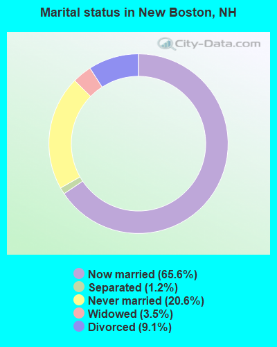
- Never married: 20.6%
- Now married: 65.6%
- Separated: 1.2%
- Widowed: 3.5%
- Divorced: 9.1%
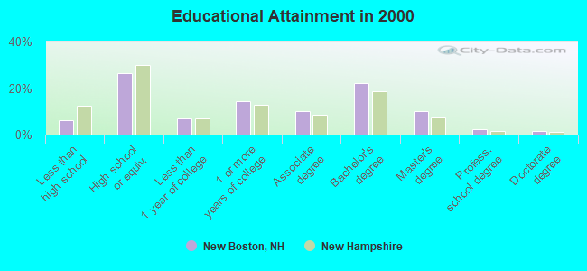
For population 25 years and over in New Boston:
- High school or higher: 93.9%
- Bachelor's degree or higher: 36.0%
- Graduate or professional degree: 14.0%
- Unemployed: 2.5%
- Mean travel time to work (commute): 32.7 minutes
| Here: | 9.8 |
| New Hampshire average: | 10.9 |


Graphs represent county-level data. Detailed 2008 Election Results
Religion statistics for New Boston, NH (based on Hillsborough County data)


| Religion | Adherents | Congregations |
|---|---|---|
| Catholic | 124,993 | 40 |
| Evangelical Protestant | 20,588 | 103 |
| Mainline Protestant | 17,794 | 60 |
| Other | 7,365 | 35 |
| Orthodox | 2,990 | 7 |
| Black Protestant | - | 1 |
| None | 226,991 | - |
Food Environment Statistics:
| This county: | 1.82 / 10,000 pop. |
| New Hampshire: | 2.14 / 10,000 pop. |
| Hillsborough County: | 0.12 / 10,000 pop. |
| New Hampshire: | 0.15 / 10,000 pop. |
| Hillsborough County: | 1.65 / 10,000 pop. |
| New Hampshire: | 1.78 / 10,000 pop. |
| This county: | 2.67 / 10,000 pop. |
| State: | 4.02 / 10,000 pop. |
| Hillsborough County: | 8.23 / 10,000 pop. |
| State: | 9.70 / 10,000 pop. |
| This county: | 6.9% |
| New Hampshire: | 7.6% |
| This county: | 24.5% |
| New Hampshire: | 24.4% |
| Here: | 15.1% |
| New Hampshire: | 15.9% |
6.73% of this county's 2021 resident taxpayers lived in other counties in 2020 ($92,767 average adjusted gross income)
| Here: | 6.73% |
| New Hampshire average: | 7.66% |
0.01% of residents moved from foreign countries ($183 average AGI)
Hillsborough County: 0.01% New Hampshire average: 0.01%
Top counties from which taxpayers relocated into this county between 2020 and 2021:
| from Middlesex County, MA | |
| from Rockingham County, NH | |
| from Merrimack County, NH |
6.49% of this county's 2020 resident taxpayers moved to other counties in 2021 ($81,100 average adjusted gross income)
| Here: | 6.49% |
| New Hampshire average: | 6.80% |
0.02% of residents moved to foreign countries ($105 average AGI)
Hillsborough County: 0.02% New Hampshire average: 0.01%
Top counties to which taxpayers relocated from this county between 2020 and 2021:
| to Rockingham County, NH | |
| to Merrimack County, NH | |
| to Middlesex County, MA |
Businesses in New Boston, NH
- U-Haul: 1
Strongest AM radio stations in New Boston:
- WGIR (610 AM; 5 kW; MANCHESTER, NH; Owner: CAPSTAR TX LIMITED PARTNERSHIP)
- WKBR (1250 AM; 5 kW; MANCHESTER, NH; Owner: DEVON BROADCASTING COMPANY, INC.)
- WRKO (680 AM; 50 kW; BOSTON, MA; Owner: ENTERCOM BOSTON LICENSE, LLC)
- WFEA (1370 AM; 5 kW; MANCHESTER, NH; Owner: SAGA COMMUNICATIONS OF NEW ENGLAND, LLC)
- WCRN (830 AM; 50 kW; WORCESTER, MA; Owner: CARTER BROADCASTING CORPORATION)
- WEEI (850 AM; 50 kW; BOSTON, MA; Owner: ENTERCOM BOSTON LICENSE, LLC)
- WKOX (1200 AM; 50 kW; FRAMINGHAM, MA; Owner: CAPSTAR TX LIMITED PARTNERSHIP)
- WDER (1320 AM; 10 kW; DERRY, NH; Owner: BLOUNT COMMUNICATIONS, INC. OF NH)
- WBIX (1060 AM; 40 kW; NATICK, MA; Owner: LANGER BROADCASTING CORPORATION)
- WWZN (1510 AM; 50 kW; BOSTON, MA; Owner: ROSE CITY RADIO CORPORATION)
- WNNZ (640 AM; 50 kW; WESTFIELD, MA; Owner: CLEAR CHANNEL BROADCASTING LICENSES, INC.)
- WBZ (1030 AM; 50 kW; BOSTON, MA; Owner: INFINITY BROADCASTING OPERATIONS, INC.)
- WVNE (760 AM; daytime; 25 kW; LEICESTER, MA; Owner: BLOUNT MASSCOM, INC.)
Strongest FM radio stations in New Boston:
- WGIR-FM (101.1 FM; MANCHESTER, NH; Owner: CAPSTAR TX LIMITED PARTNERSHIP)
- WQLL (96.5 FM; BEDFORD, NH; Owner: SAGA COMMUNICATIONS OF NEW ENGLAND, LLC)
- WLMW (90.7 FM; MANCHESTER, NH; Owner: KNOWLEDGE FOR LIFE)
- WZID (95.7 FM; MANCHESTER, NH; Owner: SAGA COMMUNICATIONS OF NEW ENGLAND, LLC)
- WFEX (92.1 FM; PETERBOROUGH, NH; Owner: FNX BROADCASTING OF NEW HAMPSHIRE LLC)
- WTPL (107.7 FM; HILLSBORO, NH; Owner: CONCORD BROADCASTING, L.L.C.)
- WNNH (99.1 FM; HENNIKER, NH; Owner: TELE-MEDIA COMPANY OF NEW HAMPSHIRE, L.L.C.)
- WHDQ (106.1 FM; CLAREMONT, NH; Owner: GREAT NORTHERN RADIO, L.L.C.)
- WVPR (89.5 FM; WINDSOR, VT; Owner: VERMONT PUBLIC RADIO)
- WNHI (93.3 FM; BELMONT, NH; Owner: CONCORD BROADCASTING, L.L.C.)
- W282AF (104.3 FM; CONCORD, NH; Owner: CONCORD BIBLE FELLOWSHIP)
- WSCY (106.9 FM; MOULTONBOROUGH, NH; Owner: NORTHEAST COMMUNICATIONS CORPORATION)
- WKNE (103.7 FM; KEENE, NH; Owner: SAGA COMMUNICATIONS OF NEW ENGLAND, LLC)
- WJJR (98.1 FM; RUTLAND, VT; Owner: 6 JOHNSON ROAD LICENSES, INC.)
- WZRT (97.1 FM; RUTLAND, VT; Owner: CAPSTAR TX LIMITED PARTNERSHIP)
- WHOB (106.3 FM; NASHUA, NH; Owner: TELE-MEDIA COMPANY OF NEW HAMPSHIRE, L.L.C.)
- WEVN (90.7 FM; KEENE, NH; Owner: NEW HAMPSHIRE PUBLIC RADIO, INC.)
- WEVO (89.1 FM; CONCORD, NH; Owner: NEW HAMPSHIRE PUBLIC RADIO)
- WVRR (101.7 FM; NEWPORT, NH; Owner: CAPSTAR TX LIMITED PARTNERSHIP)
- WJYY (105.5 FM; CONCORD, NH; Owner: CONCORD BROADCASTING, L.L.C.)
TV broadcast stations around New Boston:
- WMUR-TV (Channel 9; MANCHESTER, NH; Owner: HEARST-ARGYLE PROPERTIES, INC.)
- WNEU (Channel 60; MERRIMACK, NH; Owner: NBC SUBSIDIARY (NH), INC.)
- WFXZ-CA (Channel 24; BOSTON, MA; Owner: BOSTON BROADCASTING CORP.)
- WUNI (Channel 27; WORCESTER, MA; Owner: ENTRAVISION HOLDINGS, LLC)
- WUTF (Channel 66; MARLBOROUGH, MA; Owner: TELEFUTURA BOSTON LLC)
- WMEA-TV (Channel 26; BIDDEFORD, ME; Owner: MAINE PUBLIC BROADCASTING CORP.)
- WNDS (Channel 50; DERRY, NH; Owner: CTV OF DERRY, INC)
- WENH-TV (Channel 11; DURHAM, NH; Owner: UNIVERSITY OF NEW HAMPSHIRE)
- W29AT (Channel 29; MANCHESTER, NH; Owner: CENTER BROADCASTING CORP. OF NEW HAMPSHIRE)
- National Bridge Inventory (NBI) Statistics
- 13Number of bridges
- 79ft / 23.7mTotal length
- $40,846,000Total costs
- 20,846Total average daily traffic
- 1,057Total average daily truck traffic
- 30,845Total future (year 2042) average daily traffic
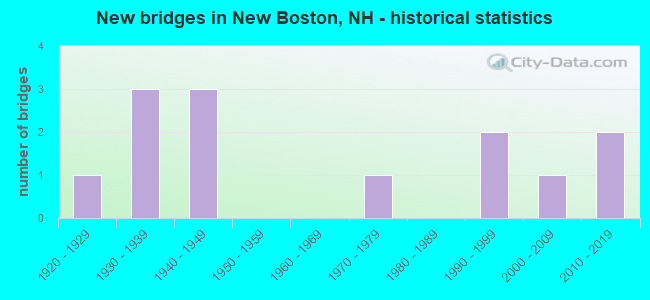
- New bridges - historical statistics
- 11920-1929
- 31930-1939
- 31940-1949
- 11970-1979
- 21990-1999
- 12000-2009
- 22010-2019
FCC Registered Antenna Towers:
2- Michael J Norton, 317 Chestnut Hill Road - New Boston Air Force Station (Lat: 42.924500 Lon: -71.647222), Type: 123.4, Overall height: 123.4 m, Registrant: 23rd Space Operations Squadron, Michael.Norton@newboston.Af.Mil, , New B-oston Afs, Phone: (603) 471-2207
- Michael J Norton, 317 Chestnut Hill Road - New Boston Air Force Station (Lat: 42.924500 Lon: -71.647222), Type: 123.4, Overall height: 123.4 m, Registrant: 23rd Space Operations Squadron, Michael.Norton@newboston.Af.Mil, , New B-oston Afs, Phone: (603) 471-2207
FCC Registered Broadcast Land Mobile Towers:
2- New Boston Police Dept Molly Stark Ln (Lat: 42.977306 Lon: -71.685917), Call Sign: KVP569,
Assigned Frequencies: 155.475 MHz, 156.090 MHz, Grant Date: 04/27/2022, Expiration Date: 07/09/2032, Registrant: Nh Dept. Of Safety/Emergency Services And Communications, 33 Hazen Dr (Mailing), Concord, NH 03305, Phone: (603) 528-7541, Fax: (603) 271-6629, Email:
- Paging Channel, 317 Chestnut Hill Road - New Boston Air Force Station (Lat: 42.924500 Lon: -71.647222), Type: Gtower, Structure height: 123.4 m, Call Sign: WQZQ942,
Assigned Frequencies: 154.822 MHz, Grant Date: 07/12/2017, Expiration Date: 07/12/2027, Cancellation Date: 01/08/2020, Certifier: Stephen T Brady, Registrant: 2-Way Communications Service, Inc., 23 River Road, Newington, NH 03801-2832, Phone: (603) 431-6288, Fax: (603) 431-4832, Email:
FCC Registered Microwave Towers:
2- STATION, New Boston/New Hampshire Airforce Sta (Lat: 42.922028 Lon: -71.649222), Overall height: 33.5 m, Call Sign: WNEX230,
Assigned Frequencies: 6735.62 MHz, Grant Date: 10/14/1998, Expiration Date: 12/16/2008, Cancellation Date: 02/21/2009, Phone: (781) 981-7684
- NBAFS, 317 Chestnut Hill Road - New Boston Air Force Station (Lat: 42.924500 Lon: -71.647222), Type: Gtower, Structure height: 123.4 m, Call Sign: WQSK994,
Assigned Frequencies: 19570.0 MHz, 19570.0 MHz, 19570.0 MHz, 19570.0 MHz, 19570.0 MHz, 19570.0 MHz, 19570.0 MHz, 19570.0 MHz, 19570.0 MHz, 19570.0 MHz... (+8 more), Grant Date: 09/23/2023, Expiration Date: 10/23/2033, Certifier: Mark Boynton, Registrant: Cara Enterprises, Inc, Las Vegas, NV 89140, Phone: (702) 838-9728, Fax: (702) 363-4607, Email:
FCC Registered Amateur Radio Licenses:
69 (See the full list of FCC Registered Amateur Radio Licenses in New Boston)FAA Registered Aircraft:
3- Aircraft: SCHLEICHER ASW-27 (Category: Land, Weight: Up to 12,499 Pounds), Engine: None
N-Number: 27FS, N27FS, N-27FS, Serial Number: 27067, Certificate Issue Date: 10/10/2019
Registrant (Co-Owned): Evan M Ludeman, 118 Thornton Rd, New Boston, NH 03070, Other Owners: Anne Marie Ludeman - Aircraft: PIPER PA-32-260 (Category: Land, Seats: 6, Weight: Up to 12,499 Pounds, Speed: 126 mph), Engine: LYCOMING 0-540 SERIES (250 HP) (Reciprocating)
N-Number: 713MT, N713MT, N-713MT, Serial Number: 32-579, Year manufactured: 1966, Airworthiness Date: 05/24/1966, Certificate Issue Date: 05/28/2020
Registrant (Individual): John A Sizemore, Po Box 301, New Boston, NH 03070 - Aircraft: DAVID KENT CAVALON (Category: Land, Seats: 2, Weight: Up to 12,499 Pounds), Engine: ROTAX 914UL (115 HP) (4 Cycle)
N-Number: 816DR, N816DR, N-816DR, Serial Number: V00317, Year manufactured: 2017, Airworthiness Date: 08/25/2017, Certificate Issue Date: 07/28/2017
Registrant (Individual): David Kent, 55 Laurel Ln, New Boston, NH 03070
2003 - 2018 National Fire Incident Reporting System (NFIRS) incidents
- Fire incident types reported to NFIRS in New Boston, NH
- 21755.2%Structure Fires
- 10927.7%Outside Fires
- 4010.2%Other
- 276.9%Mobile Property/Vehicle Fires
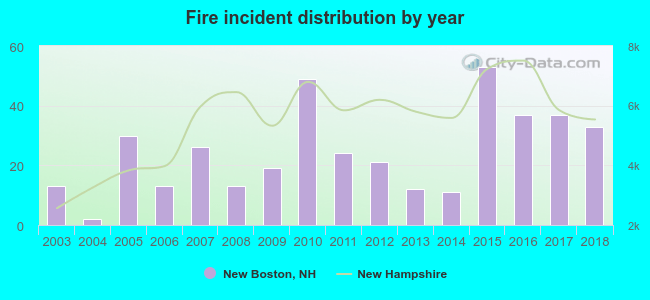 Based on the data from the years 2003 - 2018 the average number of fires per year is 25. The highest number of reported fire incidents - 53 took place in 2015, and the least - 2 in 2004. The data has a growing trend.
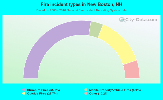 When looking into fire subcategories, the most reports belonged to: Structure Fires (55.2%), and Outside Fires (27.7%).
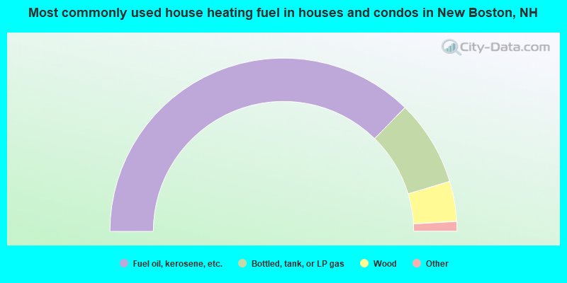
- 74.7%Fuel oil, kerosene, etc.
- 16.0%Bottled, tank, or LP gas
- 7.5%Wood
- 1.2%Utility gas
- 0.6%Electricity
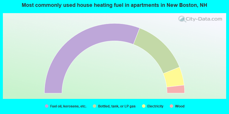
- 61.7%Fuel oil, kerosene, etc.
- 26.1%Bottled, tank, or LP gas
- 8.5%Electricity
- 3.7%Wood
New Boston compared to New Hampshire state average:
- Unemployed percentage significantly below state average.
- Black race population percentage below state average.
- Hispanic race population percentage significantly below state average.
- Foreign-born population percentage below state average.
- Renting percentage below state average.
- Length of stay since moving in significantly above state average.
- Number of rooms per house significantly below state average.
- House age significantly below state average.
New Boston on our top lists:
- #3 on the list of "Top 101 cities with largest percentage of females in industries: professional and commercial equipment and supplies merchant wholesalers (population 5,000+)"
- #6 on the list of "Top 101 cities with largest percentage of females in occupations: vehicle and mobile equipment mechanics, installers, and repairers (population 5,000+)"
- #8 on the list of "Top 101 cities with largest percentage of males in occupations: drafters, engineering, and mapping technicians (population 5,000+)"
- #17 on the list of "Top 101 cities with largest percentage of females in occupations: assemblers and fabricators (population 5,000+)"
- #18 on the list of "Top 101 cities with largest percentage of females in occupations: air transportation workers (population 5,000+)"
- #19 on the list of "Top 101 cities with largest percentage of females in occupations: special education teachers (population 5,000+)"
- #29 on the list of "Top 101 cities with largest percentage of females in industries: motor vehicle and parts dealers (population 5,000+)"
- #31 on the list of "Top 101 cities with largest percentage of females in occupations: electrical equipment mechanics and other installation, maintenance, and repair occupations including supervisors (population 5,000+)"
- #33 on the list of "Top 101 cities with largest percentage of males in industries: hardware, plumbing and heating equipment, and supplies merchant wholesalers (population 5,000+)"
- #33 on the list of "Top 101 cities with largest percentage of females in industries: data processing, libraries, and other information services (population 5,000+)"
- #34 on the list of "Top 101 cities with largest percentage of females in industries: computer and electronic products (population 5,000+)"
- #36 on the list of "Top 101 cities with largest percentage of males in industries: apparel (population 5,000+)"
- #39 on the list of "Top 101 cities with largest percentage of females in industries: broadcasting and telecommunications (population 5,000+)"
- #44 on the list of "Top 101 cities with largest percentage of males in industries: beverage and tobacco products (population 5,000+)"
- #44 on the list of "Top 101 cities with largest percentage of females in industries: personal and laundry services (population 5,000+)"
- #45 on the list of "Top 101 cities with largest percentage of males in industries: computer and electronic products (population 5,000+)"
- #58 on the list of "Top 101 cities with largest percentage of males in industries: social assistance (population 5,000+)"
- #60 on the list of "Top 101 cities with largest percentage of males in industries: groceries and related products merchant wholesalers (population 5,000+)"
- #72 on the list of "Top 101 cities with largest percentage of males in industries: motor vehicle and parts dealers (population 5,000+)"
- #79 on the list of "Top 101 cities with the largest percentage of likely lesbian couples (counted as self-reported female-female unmarried-partner households) (population 5,000+)"
- #6 on the list of "Top 101 counties with the lowest Particulate Matter (PM10) Annual air pollution readings in 2012 (µg/m3)"
- #12 on the list of "Top 101 counties with the lowest Particulate Matter (PM2.5) Annual air pollution readings in 2012 (µg/m3)"
- #15 on the list of "Top 101 counties with the lowest number of infant deaths per 1000 residents 2007-2013 (pop. 50,000+)"
- #24 on the list of "Top 101 counties with the largest decrease in the number of infant deaths per 1000 residents 2000-2006 to 2007-2013 (pop. 50,000+)"
- #44 on the list of "Top 101 counties with the lowest Nitrogen Dioxide air pollution readings in 2012 (ppm)"

|
|
Total of 251 patent applications in 2008-2024.