Mont Vernon, New Hampshire
Submit your own pictures of this town and show them to the world
- OSM Map
- General Map
- Google Map
- MSN Map
Population change since 2000: +18.4%
 |
| Males: 1,198 | |
| Females: 1,211 |
| Median resident age: | 43.2 years |
| New Hampshire median age: | 43.9 years |
Zip codes: 03057.
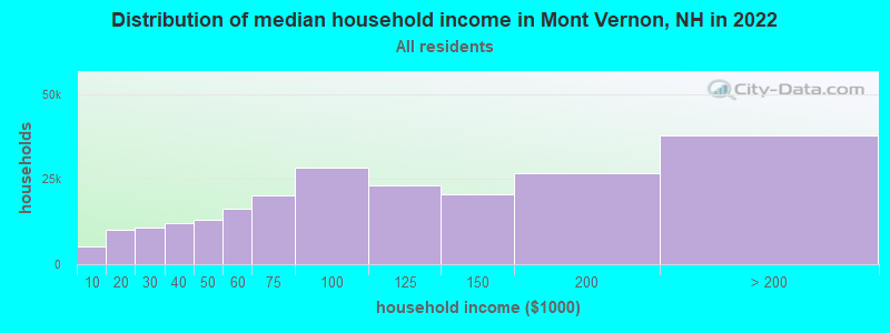
| Mont Vernon: | $129,358 |
| NH: | $89,992 |
Estimated per capita income in 2022: $61,368 (it was $30,772 in 2000)
Mont Vernon town income, earnings, and wages data
Estimated median house or condo value in 2022: $525,089 (it was $174,600 in 2000)
| Mont Vernon: | $525,089 |
| NH: | $384,700 |
Mean prices in 2022: all housing units: $411,252; detached houses: $441,251; townhouses or other attached units: $283,002; in 2-unit structures: $347,377; in 3-to-4-unit structures: $666,663; in 5-or-more-unit structures: $275,798; mobile homes: $132,093
Detailed information about poverty and poor residents in Mont Vernon, NH

Compare current foreclosures near Mont Vernon, NH:
| Photo | Address | Area | Beds / Baths | Price | Details |
|---|---|---|---|---|---|

|
#1
N Main St
Mont Vernon, NH 03057
|
- sq. feet
|
- baths - beds |
show details | |

|
#2
Spring Hill Rd
Mont Vernon, NH 03057
|
- sq. feet
|
- baths - beds |
show details | |

|
#3
Old Amherst Rd
Mont Vernon, NH 03057
|
- sq. feet
|
- baths - beds |
show details | |

|
#4
West Rd
Ashby, MA 01431
|
7,000 sq. feet
|
3 baths 10 beds |
show details | |

|
#5
Donati Dr
Hooksett, NH 03106
|
2,269 sq. feet
|
3 baths 5 beds |
show details | |

|
#6
Reagan Rd
Townsend, MA 01469
|
1,591 sq. feet
|
2 baths 3 beds |
show details | |

|
#7
Blucher St
Manchester, NH 03102
|
2,448 sq. feet
|
2 baths 3 beds |
show details | |

|
#8
Elm St
Manchester, NH 03104
|
4,352 sq. feet
|
3 baths 3 beds |
show details | |

|
#9
Juniper Dr
Amherst, NH 03031
|
3,364 sq. feet
|
4 baths 4 beds |
show details | |

|
#10
Amherst St
Amherst, NH 03031
|
- sq. feet
|
4 baths 3 beds |
show details |
| Photo | Address | Area | Beds / Baths | Price | Details |
|---|---|---|---|---|---|

|
#11
Silver St Apt 105
Manchester, NH 03103
|
924 sq. feet
|
1 baths 2 beds |
show details | |

|
#12
Arnold St
Manchester, NH 03102
|
1,792 sq. feet
|
1 baths 4 beds |
show details | |

|
#13
Liberty St # 2
Manchester, NH 03104
|
1,987 sq. feet
|
2 baths 5 beds |
show details | |

|
#14
Wiley Hill Rd
Londonderry, NH 03053
|
2,668 sq. feet
|
2 baths 3 beds |
show details | |

|
#15
Clay St # 2
Manchester, NH 03103
|
2,240 sq. feet
|
2 baths 4 beds |
show details | |

|
#16
Lucille St
Manchester, NH 03103
|
1,425 sq. feet
|
2 baths 4 beds |
show details | |

|
#17
W Elmwood Ave
Manchester, NH 03103
|
2,304 sq. feet
|
2 baths 4 beds |
show details | |

|
#18
Portage Rd
Goffstown, NH 03045
|
1,886 sq. feet
|
1 baths 3 beds |
show details | |

|
#19
W Rosemont Ave
Manchester, NH 03103
|
1,262 sq. feet
|
1 baths 2 beds |
show details | |

|
#20
Westwood Dr
Manchester, NH 03103
|
2,086 sq. feet
|
1 baths 3 beds |
show details |
| Photo | Address | Area | Beds / Baths | Price | Details |
|---|---|---|---|---|---|

|
#21
Beech Hill Ave
Manchester, NH 03103
|
1,596 sq. feet
|
1 baths 2 beds |
show details | |

|
#22
Lowell St # 1
Manchester, NH 03104
|
2,184 sq. feet
|
2 baths 6 beds |
show details | |

|
#23
Public St
Manchester, NH 03103
|
1,396 sq. feet
|
1 baths 3 beds |
show details | |

|
#24
Westland Ave
Manchester, NH 03103
|
1,752 sq. feet
|
1 baths 3 beds |
show details | |

|
#25
Parker Ave
Manchester, NH 03102
|
1,352 sq. feet
|
1 baths 3 beds |
show details | |

|
#26
Malderelli Rd
Greenville, NH 03048
|
1,098 sq. feet
|
1 baths 3 beds |
show details | |

|
#27
Normand St
Manchester, NH 03109
|
1,502 sq. feet
|
2 baths 3 beds |
show details | |

|
#28
Merrimack St # 2
Manchester, NH 03103
|
2,436 sq. feet
|
2 baths 6 beds |
show details | |

|
#29
Skyline Ave
Hooksett, NH 03106
|
928 sq. feet
|
2 baths 2 beds |
show details | |

|
#30
Haskell Rd
Pepperell, MA 01463
|
1,440 sq. feet
|
1 baths 3 beds |
show details |
| Photo | Address | Area | Beds / Baths | Price | Details |
|---|---|---|---|---|---|

|
#31
Turnpike Rd
Ashby, MA 01431
|
960 sq. feet
|
1 baths 2 beds |
show details | |

|
#32
Whitehall Rd
Hooksett, NH 03106
|
2,740 sq. feet
|
2 baths 5 beds |
show details | |

|
#33
Wedgewood Cir Unit 9
Hooksett, NH 03106
|
1,942 sq. feet
|
2 baths 2 beds |
show details | |

|
#34
Auburn Rd
Hooksett, NH 03106
|
1,800 sq. feet
|
2 baths 3 beds |
show details | |

|
#35
Hollis St
Pepperell, MA 01463
|
1,242 sq. feet
|
1 baths 3 beds |
show details | |

|
#36
Hidden Ranch Dr
Hooksett, NH 03106
|
903 sq. feet
|
1 baths 1 beds |
show details | |

|
#37
Embassy Ave
Hooksett, NH 03106
|
816 sq. feet
|
1 baths 2 beds |
show details | |

|
#38
Countryside Rd
Pepperell, MA 01463
|
1,344 sq. feet
|
1 baths 3 beds |
show details | |

|
#39
Cedar St
Manchester, NH 03103
|
2,614 sq. feet
|
2 baths 6 beds |
show details | |

|
#40
Wells St
Manchester, NH 03104
|
2,800 sq. feet
|
1 baths 3 beds |
show details |
| Photo | Address | Area | Beds / Baths | Price | Details |
|---|---|---|---|---|---|

|
#41
Megan Dr
Manchester, NH 03109
|
2,244 sq. feet
|
1 baths 3 beds |
show details | |

|
#42
Cheyenne Rd
Pepperell, MA 01463
|
1,728 sq. feet
|
2 baths 4 beds |
show details | |

|
#43
Delaware Ave # 1
Manchester, NH 03104
|
2,946 sq. feet
|
3 baths 8 beds |
show details | |

|
#44
Coral Ave
Manchester, NH 03104
|
2,464 sq. feet
|
2 baths 3 beds |
show details | |

|
#45
Brookline St
Pepperell, MA 01463
|
2,740 sq. feet
|
1 baths 3 beds |
show details | |

|
#46
Channel Ln
Goffstown, NH 03045
|
812 sq. feet
|
1 baths 2 beds |
show details | |

|
#47
Yorkway Dr
Nashua, NH 03062
|
- sq. feet
|
3 baths 3 beds |
show details | |

|
#48
Brown Ave
Manchester, NH 03103
|
1,296 sq. feet
|
1 baths 4 beds |
show details | |

|
#49
Main St
Dunstable, MA 01827
|
2,452 sq. feet
|
2 baths 3 beds |
show details | |

|
Check over 1 million property listings on Foreclosure.com!
|
browse all offers | |||

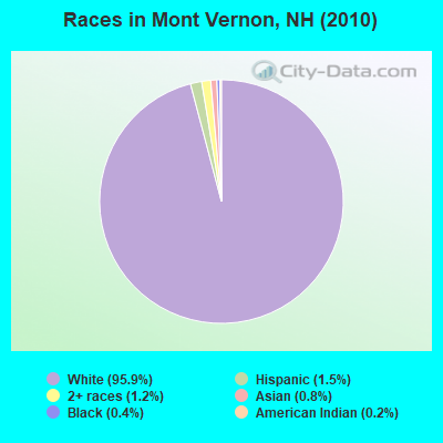
- 2,31095.9%White alone
- 371.5%Hispanic
- 281.2%Two or more races
- 200.8%Asian alone
- 100.4%Black alone
- 40.2%American Indian alone
Races in Mont Vernon detailed stats: ancestries, foreign born residents, place of birth
According to our research of New Hampshire and other state lists, there were 2 registered sex offenders living in Mont Vernon, New Hampshire as of May 17, 2024.
The ratio of all residents to sex offenders in Mont Vernon is 1,205 to 1.
The ratio of registered sex offenders to all residents in this city is lower than the state average.
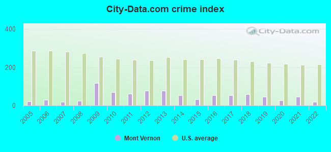
Type |
2009 |
2010 |
2011 |
2012 |
2013 |
2014 |
2015 |
2016 |
2017 |
2018 |
2019 |
2020 |
2021 |
2022 |
|---|---|---|---|---|---|---|---|---|---|---|---|---|---|---|
| Murders (per 100,000) | 1 (41.6) | 0 (0.0) | 0 (0.0) | 0 (0.0) | 0 (0.0) | 0 (0.0) | 0 (0.0) | 0 (0.0) | 0 (0.0) | 0 (0.0) | 0 (0.0) | 0 (0.0) | 0 (0.0) | 0 (0.0) |
| Rapes (per 100,000) | 0 (0.0) | 0 (0.0) | 0 (0.0) | 1 (41.3) | 1 (41.2) | 0 (0.0) | 0 (0.0) | 1 (40.2) | 1 (39.7) | 1 (39.1) | 1 (38.4) | 0 (0.0) | 1 (36.4) | 0 (0.0) |
| Robberies (per 100,000) | 0 (0.0) | 0 (0.0) | 0 (0.0) | 0 (0.0) | 0 (0.0) | 0 (0.0) | 0 (0.0) | 0 (0.0) | 0 (0.0) | 0 (0.0) | 0 (0.0) | 0 (0.0) | 0 (0.0) | 0 (0.0) |
| Assaults (per 100,000) | 1 (41.6) | 4 (166.0) | 1 (41.5) | 1 (41.3) | 1 (41.2) | 4 (163.7) | 1 (40.5) | 0 (0.0) | 0 (0.0) | 2 (78.3) | 1 (38.4) | 0 (0.0) | 0 (0.0) | 1 (38.2) |
| Burglaries (per 100,000) | 4 (166.4) | 3 (124.5) | 12 (497.5) | 4 (165.3) | 7 (288.4) | 1 (40.9) | 2 (81.0) | 1 (40.2) | 5 (198.5) | 1 (39.1) | 0 (0.0) | 0 (0.0) | 1 (36.4) | 0 (0.0) |
| Thefts (per 100,000) | 9 (374.4) | 12 (498.1) | 8 (331.7) | 10 (413.2) | 8 (329.6) | 6 (245.6) | 12 (486.2) | 12 (482.9) | 4 (158.8) | 6 (234.8) | 5 (192.1) | 16 (595.7) | 10 (363.8) | 7 (267.5) |
| Auto thefts (per 100,000) | 0 (0.0) | 2 (83.0) | 1 (41.5) | 2 (82.6) | 1 (41.2) | 2 (81.9) | 0 (0.0) | 0 (0.0) | 0 (0.0) | 0 (0.0) | 0 (0.0) | 1 (37.2) | 0 (0.0) | 0 (0.0) |
| Arson (per 100,000) | 1 (41.6) | 0 (0.0) | 0 (0.0) | 1 (41.3) | 0 (0.0) | 0 (0.0) | 2 (81.0) | 1 (40.2) | 0 (0.0) | 1 (39.1) | 0 (0.0) | 0 (0.0) | 0 (0.0) | 0 (0.0) |
| City-Data.com crime index | 118.1 | 68.5 | 59.7 | 76.0 | 77.9 | 52.0 | 33.2 | 54.3 | 52.0 | 59.1 | 46.1 | 26.8 | 46.2 | 18.3 |
The City-Data.com crime index weighs serious crimes and violent crimes more heavily. Higher means more crime, U.S. average is 246.1. It adjusts for the number of visitors and daily workers commuting into cities.
Crime rate in Mont Vernon detailed stats: murders, rapes, robberies, assaults, burglaries, thefts, arson
Full-time law enforcement employees in 2021, including police officers: 4 (3 officers - 3 male; 0 female).
| Officers per 1,000 residents here: | 1.09 |
| New Hampshire average: | 2.14 |
 Recent articles from our blog. Our writers, many of them Ph.D. graduates or candidates, create easy-to-read articles on a wide variety of topics.

 | Mont Vernon property (9 replies) |
| where to start a family in NH? (37 replies) |
| Murder in Mont Vernon (185 replies) |
| Moving to the Manchester Area - Advice Please :) (13 replies) |
| Fall Colors (19 replies) |
| Relocating (20 replies) |
Latest news from Mont Vernon, NH collected exclusively by city-data.com from local newspapers, TV, and radio stations
Ancestries: English (22.8%), Irish (16.8%), German (13.3%), French (11.2%), United States (10.2%), Italian (9.8%).
Current Local Time: EST time zone
Incorporated in 1803
Elevation: 825 feet
Land area: 16.6 square miles.
Population density: 145 people per square mile (very low).
51 residents are foreign born (1.3% North America, 0.9% Europe).
| This town: | 2.5% |
| New Hampshire: | 4.4% |
| Mont Vernon town: | 2.4% ($4,111) |
| New Hampshire: | 2.3% ($2,946) |
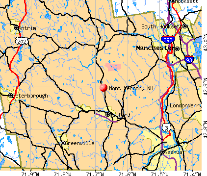
Nearest city with pop. 50,000+: Manchester, NH  (13.0 miles , pop. 107,006).
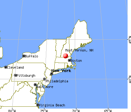
Nearest city with pop. 200,000+: Boston, MA (49.7 miles , pop. 589,141).
Nearest city with pop. 1,000,000+: Bronx, NY (181.3 miles , pop. 1,332,650).
Nearest cities:
), ), )Latitude: 42.89 N, Longitude: 71.68 W
Area code commonly used in this area: 603

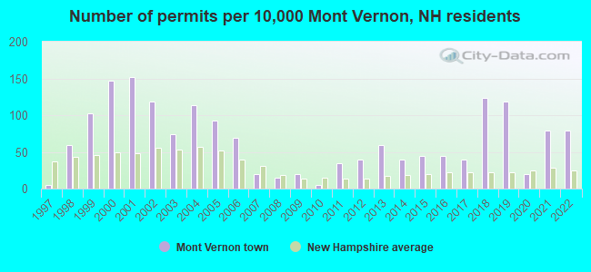
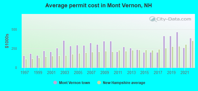
Single-family new house construction building permits:
- 2022: 16 buildings, average cost: $386,000
- 2021: 16 buildings, average cost: $262,500
- 2020: 4 buildings, average cost: $467,500
- 2019: 24 buildings, average cost: $416,600
- 2018: 25 buildings, average cost: $416,600
- 2017: 8 buildings, average cost: $201,100
- 2016: 9 buildings, average cost: $201,100
- 2015: 9 buildings, average cost: $201,100
- 2014: 8 buildings, average cost: $236,000
- 2013: 12 buildings, average cost: $257,100
- 2012: 8 buildings, average cost: $272,600
- 2011: 7 buildings, average cost: $210,400
- 2010: 1 building, cost: $347,300
- 2009: 4 buildings, average cost: $347,300
- 2008: 3 buildings, average cost: $303,500
- 2007: 4 buildings, average cost: $325,000
- 2006: 14 buildings, average cost: $292,800
- 2005: 19 buildings, average cost: $295,900
- 2004: 23 buildings, average cost: $284,800
- 2003: 15 buildings, average cost: $355,500
- 2002: 24 buildings, average cost: $256,200
- 2001: 31 buildings, average cost: $208,300
- 2000: 30 buildings, average cost: $222,300
- 1999: 21 buildings, average cost: $160,800
- 1998: 12 buildings, average cost: $185,500
- 1997: 1 building, cost: $160,000
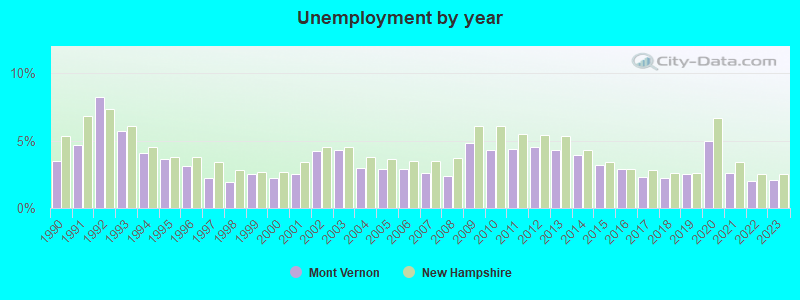
| Here: | 2.1% |
| New Hampshire: | 2.5% |
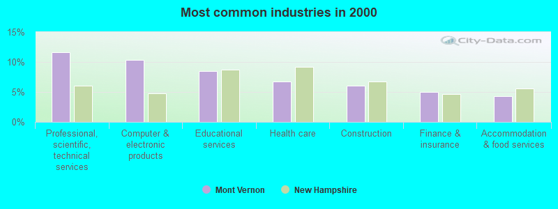
- Professional, scientific, technical services (11.6%)
- Computer & electronic products (10.3%)
- Educational services (8.5%)
- Health care (6.7%)
- Construction (6.1%)
- Finance & insurance (5.0%)
- Accommodation & food services (4.3%)
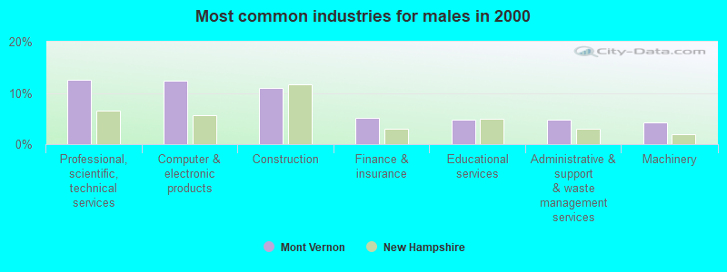
- Professional, scientific, technical services (12.5%)
- Computer & electronic products (12.3%)
- Construction (11.0%)
- Finance & insurance (5.2%)
- Educational services (4.8%)
- Administrative & support & waste management services (4.8%)
- Machinery (4.3%)
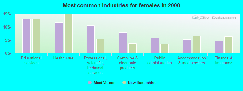
- Educational services (13.0%)
- Health care (11.8%)
- Professional, scientific, technical services (10.6%)
- Computer & electronic products (7.9%)
- Public administration (5.8%)
- Accommodation & food services (5.2%)
- Finance & insurance (4.8%)
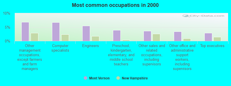
- Other management occupations, except farmers and farm managers (6.8%)
- Computer specialists (6.7%)
- Engineers (5.4%)
- Preschool, kindergarten, elementary, and middle school teachers (3.9%)
- Other sales and related occupations, including supervisors (3.6%)
- Other office and administrative support workers, including supervisors (3.4%)
- Top executives (2.9%)
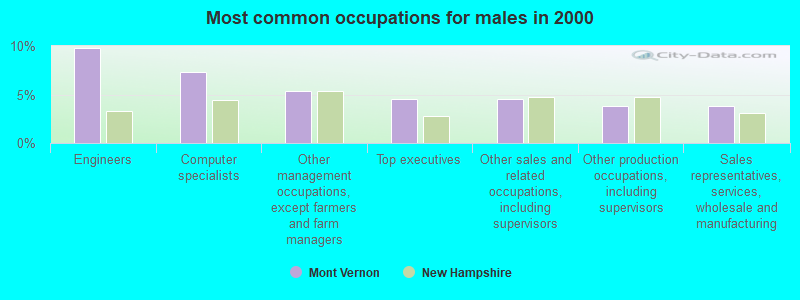
- Engineers (9.8%)
- Computer specialists (7.3%)
- Other management occupations, except farmers and farm managers (5.3%)
- Top executives (4.5%)
- Other sales and related occupations, including supervisors (4.5%)
- Other production occupations, including supervisors (3.8%)
- Sales representatives, services, wholesale and manufacturing (3.8%)

- Other management occupations, except farmers and farm managers (8.7%)
- Other office and administrative support workers, including supervisors (7.2%)
- Preschool, kindergarten, elementary, and middle school teachers (6.2%)
- Computer specialists (6.0%)
- Retail sales workers, except cashiers (5.0%)
- Registered nurses (4.8%)
- Secretaries and administrative assistants (4.1%)
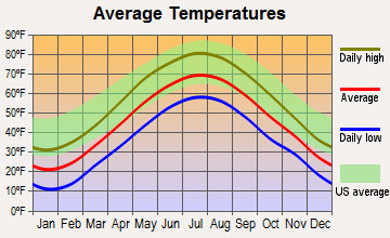
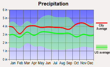
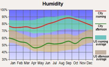
Average climate in Mont Vernon, New Hampshire
Based on data reported by over 4,000 weather stations
(lower is better)
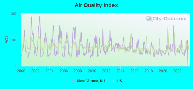
Air Quality Index (AQI) level in 2022 was 60.7. This is about average.
| City: | 60.7 |
| U.S.: | 72.6 |

Carbon Monoxide (CO) [ppm] level in 2022 was 0.141. This is significantly better than average. Closest monitor was 10.5 miles away from the city center.
| City: | 0.141 |
| U.S.: | 0.251 |
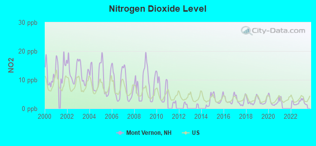
Nitrogen Dioxide (NO2) [ppb] level in 2022 was 2.05. This is significantly better than average. Closest monitor was 10.5 miles away from the city center.
| City: | 2.05 |
| U.S.: | 5.11 |
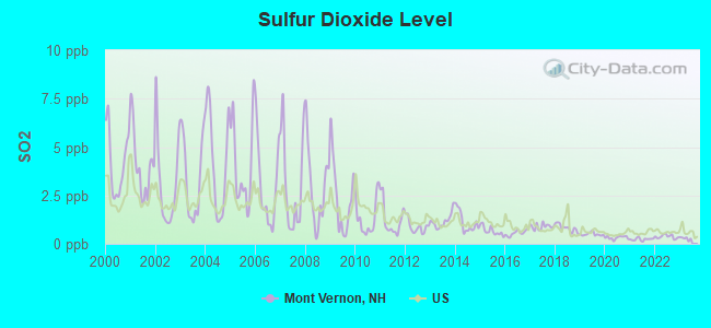
Sulfur Dioxide (SO2) [ppb] level in 2022 was 0.370. This is significantly better than average. Closest monitor was 10.5 miles away from the city center.
| City: | 0.370 |
| U.S.: | 1.515 |
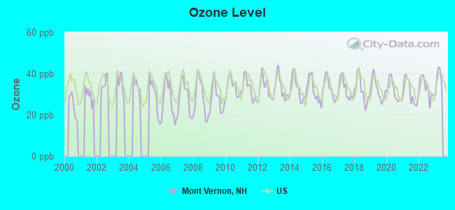
Ozone [ppb] level in 2022 was 33.1. This is about average. Closest monitor was 10.5 miles away from the city center.
| City: | 33.1 |
| U.S.: | 33.3 |
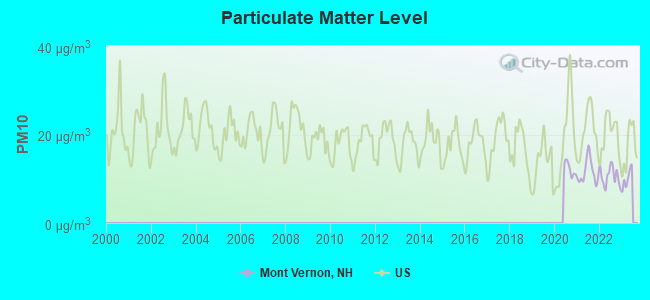
Particulate Matter (PM10) [µg/m3] level in 2022 was 10.6. This is significantly better than average. Closest monitor was 10.5 miles away from the city center.
| City: | 10.6 |
| U.S.: | 19.2 |
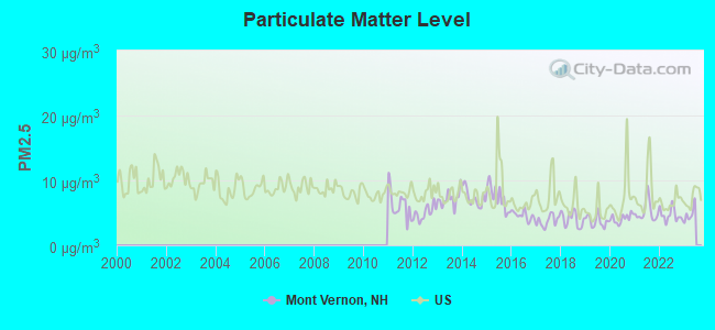
Particulate Matter (PM2.5) [µg/m3] level in 2022 was 4.67. This is significantly better than average. Closest monitor was 10.5 miles away from the city center.
| City: | 4.67 |
| U.S.: | 8.11 |
Tornado activity:
Mont Vernon-area historical tornado activity is above New Hampshire state average. It is 30% smaller than the overall U.S. average.
On 6/9/1953, a category F4 (max. wind speeds 207-260 mph) tornado 38.7 miles away from the Mont Vernon town center killed 90 people and injured 1228 people and caused between $50,000,000 and $500,000,000 in damages.
On 10/3/1970, a category F3 (max. wind speeds 158-206 mph) tornado 23.8 miles away from the town center killed one person and caused between $50,000 and $500,000 in damages.
Earthquake activity:
Mont Vernon-area historical earthquake activity is significantly above New Hampshire state average. It is 71% smaller than the overall U.S. average.On 4/20/2002 at 10:50:47, a magnitude 5.3 (5.3 ML, Depth: 3.0 mi, Class: Moderate, Intensity: VI - VII) earthquake occurred 150.8 miles away from Mont Vernon center
On 10/7/1983 at 10:18:46, a magnitude 5.3 (5.1 MB, 5.3 LG, 5.1 ML) earthquake occurred 152.6 miles away from Mont Vernon center
On 1/19/1982 at 00:14:42, a magnitude 4.7 (4.5 MB, 4.7 MD, 4.5 LG, Class: Light, Intensity: IV - V) earthquake occurred 42.0 miles away from the city center
On 4/20/2002 at 10:50:47, a magnitude 5.2 (5.2 MB, 4.2 MS, 5.2 MW, 5.0 MW) earthquake occurred 150.2 miles away from Mont Vernon center
On 10/16/2012 at 23:12:25, a magnitude 4.7 (4.7 ML, Depth: 10.0 mi) earthquake occurred 70.7 miles away from the city center
On 10/2/1994 at 11:27:22, a magnitude 3.7 (3.5 LG, 3.7 LG, Depth: 6.2 mi, Class: Light, Intensity: II - III) earthquake occurred 48.7 miles away from the city center
Magnitude types: regional Lg-wave magnitude (LG), body-wave magnitude (MB), duration magnitude (MD), local magnitude (ML), surface-wave magnitude (MS), moment magnitude (MW)
Natural disasters:
The number of natural disasters in Hillsborough County (27) is a lot greater than the US average (15).Major Disasters (Presidential) Declared: 17
Emergencies Declared: 10
Causes of natural disasters: Storms: 13, Floods: 11, Winter Storms: 5, Snowstorms: 4, Hurricanes: 3, Snows: 3, Blizzard: 1, Ice Storm: 1, Snowfall: 1, Wind: 1 (Note: some incidents may be assigned to more than one category).
Hospitals and medical centers near Mont Vernon:
- ST JOSEPH HOME AND HOSPICE CARE (Home Health Center, about 4 miles away; MILFORD, NH)
- CRESTWOOD CARE AND REHABILITATION CENTER (Nursing Home, about 5 miles away; MILFORD, NH)
- ELM'S NURSING AND REHAB CENTER (THE) (Nursing Home, about 5 miles away; MILFORD, NH)
- LAUREL CENTER (Nursing Home, about 11 miles away; BEDFORD, NH)
- HILLSBOROUGH COUNTY NURSING HOME (Nursing Home, about 11 miles away; GOFFSTOWN, NH)
- RIDGEWOOD CENTER, GENESIS HEALTHCARE (Nursing Home, about 11 miles away; BEDFORD, NH)
- BEL AIR NURSING HOME (Nursing Home, about 11 miles away; GOFFSTOWN, NH)
Colleges/universities with over 2000 students nearest to Mont Vernon:
- Saint Anselm College (about 11 miles; Manchester, NH; Full-time enrollment: 2,059)
- Mount Washington College (about 12 miles; Manchester, NH; FT enrollment: 2,187)
- Southern New Hampshire University (about 16 miles; Manchester, NH; FT enrollment: 16,552)
- Franklin Pierce University (about 21 miles; Rindge, NH; FT enrollment: 2,139)
- Fitchburg State University (about 22 miles; Fitchburg, MA; FT enrollment: 5,010)
- NHTI-Concord's Community College (about 24 miles; Concord, NH; FT enrollment: 2,865)
- University of Massachusetts-Lowell (about 25 miles; Lowell, MA; FT enrollment: 12,341)
Public elementary/middle school in Mont Vernon:
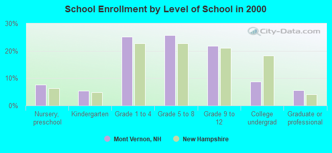
- MONT VERNON VILLAGE SCHOOL (Students: 248, Location: HARWOOD RD., Grades: KG-6)
Points of interest:
Notable location: Mont Vernon Fire Department (A). Display/hide its location on the map
Church in Mont Vernon: Mont Vernon Congregational Church (A). Display/hide its location on the map
Cemetery: Greenlawn Cemetery (1). Display/hide its location on the map
Lakes and reservoirs: Hortons Pond (A), Ice Pond (B), Jew Pond (C), Roby Pond (D), Stearns Pond (E), Woods Pond (F). Display/hide their locations on the map
Streams, rivers, and creeks: Curtis Brook (A), Black Brook (B). Display/hide their locations on the map
Park in Mont Vernon: George O. Carleton Park (1). Display/hide its location on the map
Birthplace of: Doc Adams - Baseball player and executive, George Wilkins Kendall - Journalist, William Trevitt - Ohio politician.
Drinking water stations with addresses in Mont Vernon and their reported violations in the past:
PLYMOUTH MOBIL (Population served: 300, Groundwater):Past health violations:Past monitoring violations:
- MCL, Monthly (TCR) - Between JUL-2013 and SEP-2013, Contaminant: Coliform. Follow-up actions: St Public Notif requested (SEP-03-2013), St Violation/Reminder Notice (SEP-03-2013), St Public Notif received (OCT-24-2013), St Formal NOV issued (OCT-28-2013), St Compliance achieved (FEB-07-2014)
- Monitoring, Source Water (GWR) - Between JUL-20-2013 and AUG-20-2013, Contaminant: E. COLI. Follow-up actions: St Compliance achieved (AUG-13-2013), St Public Notif requested (AUG-21-2013), St Violation/Reminder Notice (AUG-21-2013), St Public Notif received (SEP-05-2013)
- Monitoring, Repeat Major (TCR) - Between JUL-2013 and SEP-2013, Contaminant: Coliform (TCR). Follow-up actions: St Compliance achieved (AUG-13-2013), St Public Notif requested (AUG-21-2013), St Violation/Reminder Notice (AUG-21-2013), St Public Notif received (SEP-05-2013)
- 8 routine major monitoring violations
| This town: | 2.9 people |
| New Hampshire: | 2.5 people |
| This town: | 81.9% |
| Whole state: | 66.3% |
| This town: | 4.1% |
| Whole state: | 8.3% |
Likely homosexual households (counted as self-reported same-sex unmarried-partner households)
- Lesbian couples: 0.6% of all households
- Gay men: 0.6% of all households
| This town: | 2.0% |
| Whole state: | 6.5% |
| This town: | 0.3% |
| Whole state: | 2.8% |
23 people in other noninstitutional group quarters in 2000
For population 15 years and over in Mont Vernon:
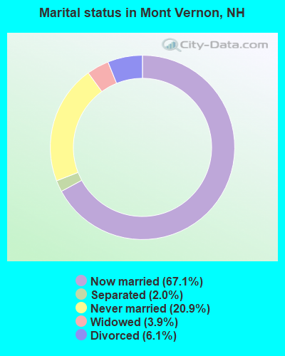
- Never married: 20.9%
- Now married: 67.1%
- Separated: 2.0%
- Widowed: 3.9%
- Divorced: 6.1%
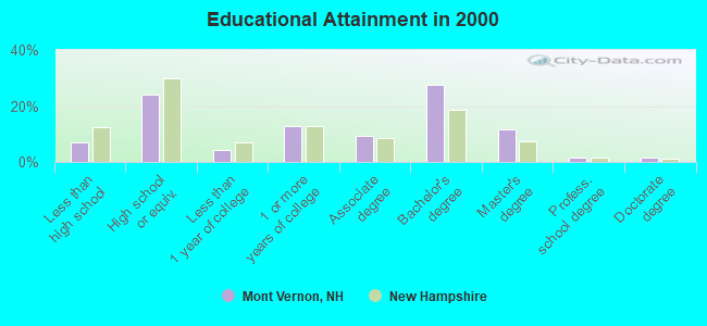
For population 25 years and over in Mont Vernon:
- High school or higher: 93.1%
- Bachelor's degree or higher: 42.3%
- Graduate or professional degree: 14.8%
- Unemployed: 4.8%
- Mean travel time to work (commute): 32.5 minutes
| Here: | 9.9 |
| New Hampshire average: | 10.9 |


Graphs represent county-level data. Detailed 2008 Election Results
Religion statistics for Mont Vernon, NH (based on Hillsborough County data)


| Religion | Adherents | Congregations |
|---|---|---|
| Catholic | 124,993 | 40 |
| Evangelical Protestant | 20,588 | 103 |
| Mainline Protestant | 17,794 | 60 |
| Other | 7,365 | 35 |
| Orthodox | 2,990 | 7 |
| Black Protestant | - | 1 |
| None | 226,991 | - |
Food Environment Statistics:
| Hillsborough County: | 1.82 / 10,000 pop. |
| New Hampshire: | 2.14 / 10,000 pop. |
| Here: | 0.12 / 10,000 pop. |
| State: | 0.15 / 10,000 pop. |
| Here: | 1.65 / 10,000 pop. |
| New Hampshire: | 1.78 / 10,000 pop. |
| Hillsborough County: | 2.67 / 10,000 pop. |
| State: | 4.02 / 10,000 pop. |
| Hillsborough County: | 8.23 / 10,000 pop. |
| State: | 9.70 / 10,000 pop. |
| Hillsborough County: | 6.9% |
| State: | 7.6% |
| This county: | 24.5% |
| State: | 24.4% |
| This county: | 15.1% |
| New Hampshire: | 15.9% |
6.73% of this county's 2021 resident taxpayers lived in other counties in 2020 ($92,767 average adjusted gross income)
| Here: | 6.73% |
| New Hampshire average: | 7.66% |
0.01% of residents moved from foreign countries ($183 average AGI)
Hillsborough County: 0.01% New Hampshire average: 0.01%
Top counties from which taxpayers relocated into this county between 2020 and 2021:
| from Middlesex County, MA | |
| from Rockingham County, NH | |
| from Merrimack County, NH |
6.49% of this county's 2020 resident taxpayers moved to other counties in 2021 ($81,100 average adjusted gross income)
| Here: | 6.49% |
| New Hampshire average: | 6.80% |
0.02% of residents moved to foreign countries ($105 average AGI)
Hillsborough County: 0.02% New Hampshire average: 0.01%
Top counties to which taxpayers relocated from this county between 2020 and 2021:
| to Rockingham County, NH | |
| to Merrimack County, NH | |
| to Middlesex County, MA |
Strongest AM radio stations in Mont Vernon:
- WRKO (680 AM; 50 kW; BOSTON, MA; Owner: ENTERCOM BOSTON LICENSE, LLC)
- WGIR (610 AM; 5 kW; MANCHESTER, NH; Owner: CAPSTAR TX LIMITED PARTNERSHIP)
- WFEA (1370 AM; 5 kW; MANCHESTER, NH; Owner: SAGA COMMUNICATIONS OF NEW ENGLAND, LLC)
- WKBR (1250 AM; 5 kW; MANCHESTER, NH; Owner: DEVON BROADCASTING COMPANY, INC.)
- WCRN (830 AM; 50 kW; WORCESTER, MA; Owner: CARTER BROADCASTING CORPORATION)
- WEEI (850 AM; 50 kW; BOSTON, MA; Owner: ENTERCOM BOSTON LICENSE, LLC)
- WKOX (1200 AM; 50 kW; FRAMINGHAM, MA; Owner: CAPSTAR TX LIMITED PARTNERSHIP)
- WBIX (1060 AM; 40 kW; NATICK, MA; Owner: LANGER BROADCASTING CORPORATION)
- WDER (1320 AM; 10 kW; DERRY, NH; Owner: BLOUNT COMMUNICATIONS, INC. OF NH)
- WWZN (1510 AM; 50 kW; BOSTON, MA; Owner: ROSE CITY RADIO CORPORATION)
- WSMN (1590 AM; 5 kW; NASHUA, NH; Owner: 1590 BROADCASTING CORP.)
- WBZ (1030 AM; 50 kW; BOSTON, MA; Owner: INFINITY BROADCASTING OPERATIONS, INC.)
- WNNZ (640 AM; 50 kW; WESTFIELD, MA; Owner: CLEAR CHANNEL BROADCASTING LICENSES, INC.)
Strongest FM radio stations in Mont Vernon:
- WGIR-FM (101.1 FM; MANCHESTER, NH; Owner: CAPSTAR TX LIMITED PARTNERSHIP)
- WQLL (96.5 FM; BEDFORD, NH; Owner: SAGA COMMUNICATIONS OF NEW ENGLAND, LLC)
- WLMW (90.7 FM; MANCHESTER, NH; Owner: KNOWLEDGE FOR LIFE)
- WZID (95.7 FM; MANCHESTER, NH; Owner: SAGA COMMUNICATIONS OF NEW ENGLAND, LLC)
- WFEX (92.1 FM; PETERBOROUGH, NH; Owner: FNX BROADCASTING OF NEW HAMPSHIRE LLC)
- WTPL (107.7 FM; HILLSBORO, NH; Owner: CONCORD BROADCASTING, L.L.C.)
- WHDQ (106.1 FM; CLAREMONT, NH; Owner: GREAT NORTHERN RADIO, L.L.C.)
- WNNH (99.1 FM; HENNIKER, NH; Owner: TELE-MEDIA COMPANY OF NEW HAMPSHIRE, L.L.C.)
- WHOB (106.3 FM; NASHUA, NH; Owner: TELE-MEDIA COMPANY OF NEW HAMPSHIRE, L.L.C.)
- WVPR (89.5 FM; WINDSOR, VT; Owner: VERMONT PUBLIC RADIO)
- WNHI (93.3 FM; BELMONT, NH; Owner: CONCORD BROADCASTING, L.L.C.)
- WSCY (106.9 FM; MOULTONBOROUGH, NH; Owner: NORTHEAST COMMUNICATIONS CORPORATION)
- WKNE (103.7 FM; KEENE, NH; Owner: SAGA COMMUNICATIONS OF NEW ENGLAND, LLC)
- WXLO (104.5 FM; FITCHBURG, MA; Owner: CITADEL BROADCASTING COMPANY)
- WEVN (90.7 FM; KEENE, NH; Owner: NEW HAMPSHIRE PUBLIC RADIO, INC.)
- WKLB-FM (99.5 FM; LOWELL, MA; Owner: GREATER BOSTON RADIO, INC.)
- WXRV (92.5 FM; HAVERHILL, MA; Owner: BEANPOT BROADCASTING CORP.)
- W282AF (104.3 FM; CONCORD, NH; Owner: CONCORD BIBLE FELLOWSHIP)
- WAAF (107.3 FM; WORCESTER, MA; Owner: ENTERCOM BOSTON LICENSE, LLC)
- WBMX (98.5 FM; BOSTON, MA; Owner: INFINITY RADIO OPERATIONS INC.)
TV broadcast stations around Mont Vernon:
- WMUR-TV (Channel 9; MANCHESTER, NH; Owner: HEARST-ARGYLE PROPERTIES, INC.)
- WUTF (Channel 66; MARLBOROUGH, MA; Owner: TELEFUTURA BOSTON LLC)
- WCVB-TV (Channel 5; BOSTON, MA; Owner: WCVB HEARST-ARGYLE TV, INC.)
- WUNI (Channel 27; WORCESTER, MA; Owner: ENTRAVISION HOLDINGS, LLC)
- WFXZ-CA (Channel 24; BOSTON, MA; Owner: BOSTON BROADCASTING CORP.)
- WNDS (Channel 50; DERRY, NH; Owner: CTV OF DERRY, INC)
- WGBH-TV (Channel 2; BOSTON, MA; Owner: WGBH EDUCATIONAL FOUNDATION)
- WNEU (Channel 60; MERRIMACK, NH; Owner: NBC SUBSIDIARY (NH), INC.)
- WMFP (Channel 62; LAWRENCE, MA; Owner: WSAH LICENSE, INC.)
- WBZ-TV (Channel 4; BOSTON, MA; Owner: VIACOM INC.)
- WGBX-TV (Channel 44; BOSTON, MA; Owner: WGBH EDUCATIONAL FOUNDATION)
- WSBK-TV (Channel 38; BOSTON, MA; Owner: VIACOM INC.)
- WLVI-TV (Channel 56; CAMBRIDGE, MA; Owner: WLVI, INC.)
- WFXT (Channel 25; BOSTON, MA; Owner: FOX TELEVISION STATIONS INC.)
- W29AT (Channel 29; MANCHESTER, NH; Owner: CENTER BROADCASTING CORP. OF NEW HAMPSHIRE)
- W33AK (Channel 33; NASHUA, NH; Owner: CENTER B/CING CORPORATION OF NEW HAMPSHIRE)
- WYCN-LP (Channel 13; NASHUA, NH; Owner: CENTER BROADCASTING CORP. OF NEW HAMPSHIRE)
- National Bridge Inventory (NBI) Statistics
- 1Number of bridges
- 3ft / 0.9mTotal length
- $3,142,000Total costs
- 608Total average daily traffic
- 24Total average daily truck traffic
- 899Total future (year 2042) average daily traffic
FCC Registered Cell Phone Towers:
1- Mont Vernon Cell Site: Upton Road (Lat: 42.892917 Lon: -71.679833), Type: Tower, Structure height: 54.9 m, Overall height: 60.7 m, Call Sign: KNKA483
Assigned Frequencies: 869.040 MHz, 869.040 MHz, 869.040 MHz, 824.040 MHz, 824.040 MHz, 824.040 MHz, 890.010 MHz, 890.010 MHz, 890.010 MHz, 845.010 MHz, 845.010 MHz, 845.010 MHzGrant Date: 01/23/2018, Expiration Date: 01/22/2028, Certifier: Steven T CampbellRegistrant: Wilkinson Barker Knauer, LLP, 1800 M Street Nw, Suite 800n, Washington, DC 20036, Phone: (202) 383-3420, Fax: (202) 783-5851, Email:
FCC Registered Antenna Towers:
2- Edward G Roach, 52 Cross Road (Nh11633-S) (Lat: 42.927472 Lon: -71.692250), Type: 48.8, Overall height: 45.7 m, Registrant: Sba Towers Ii LLC, Eroach@sbasite.Com, , Boca -Raton, Phone: (561) 995-7670
- Edward G Roach, 52 Cross Road (Nh11633-S) (Lat: 42.927472 Lon: -71.692250), Type: 48.8, Overall height: 45.7 m, Registrant: Sba Towers Ii LLC, Eroach@sbasite.Com, , Boca -Raton, Phone: (561) 995-7670
FCC Registered Broadcast Land Mobile Towers:
3- 1 Main Street (Lat: 42.893306 Lon: -71.674222), Type: Bant, Structure height: 9.1 m, Overall height: 15 m, Call Sign: WQLT424,
Assigned Frequencies: 155.827 MHz, Grant Date: 03/31/2020, Expiration Date: 04/20/2030, Certifier: Laurie Brown, Registrant: Cara Enterprises Inc., Las Vegas, NV 89140-0124, Phone: (801) 278-9728, Fax: (801) 278-7239, Email:
- 1 Main Street (Lat: 42.893306 Lon: -71.674222), Type: Bant, Structure height: 9.1 m, Overall height: 15 m, Call Sign: WRKQ745,
Assigned Frequencies: 150.972 MHz, Grant Date: 02/01/2021, Expiration Date: 02/01/2031, Certifier: Ben Crosby, Registrant: Cara Enterprises Inc., Las Vegas, NV 89140-0124, Phone: (801) 278-9728, Fax: (801) 278-7239, Email:
- Call Sign: WRND728,
Assigned Frequencies: 154.160 MHz, 153.770 MHz, Grant Date: 07/20/2021, Expiration Date: 07/20/2031, Certifier: Laurie Brown, Registrant: Cara Enterprises Inc., Las Vegas, NV 89140-0124, Phone: (801) 278-9728, Fax: (801) 278-7239, Email:
FCC Registered Amateur Radio Licenses:
34 (See the full list of FCC Registered Amateur Radio Licenses in Mont Vernon)FAA Registered Aircraft:
3- Aircraft: CESSNA 170B (Category: Land, Seats: 4, Weight: Up to 12,499 Pounds, Speed: 105 mph), Engine: CONT MOTOR C145 SERIES (145 HP) (Reciprocating)
N-Number: 3093A, N3093A, N-3093A, Serial Number: 25737, Airworthiness Date: 02/14/1956, Certificate Issue Date: 08/30/2018
Registrant (Individual): Paul D Santana, 13 Purgatory Rd, Mont Vernon, NH 03057
Deregistered: Cancel Date: 07/15/2013 - Aircraft: PIPER PA-22-108 (Category: Land, Seats: 2, Weight: Up to 12,499 Pounds, Speed: 94 mph), Engine: LYCOMING 0-235 SERIES (115 HP) (Reciprocating)
N-Number: 5573Z, N5573Z, N-5573Z, Serial Number: 22-9373, Year manufactured: 1962, Airworthiness Date: 06/08/1962, Certificate Issue Date: 08/11/2011
Registrant (Individual): David Herrick, 18 Tater St, Mont Vernon, NH 03057 - Aircraft: CESSNA R172E (Category: Land, Seats: 4, Weight: Up to 12,499 Pounds, Speed: 108 mph), Engine: CONT MOTOR IO-360 SER (300 HP) (Reciprocating)
N-Number: 88779, N88779, N-88779, Serial Number: R1720132, Year manufactured: 1967, Airworthiness Date: 06/28/1973, Certificate Issue Date: 11/26/2003
Registrant (Individual): Robert C Dba Haynes, 18 S Main St, Mont Vernon, NH 03057, Other Owners: Vernon Views Mont
2003 - 2018 National Fire Incident Reporting System (NFIRS) incidents
- Fire incident types reported to NFIRS in Mont Vernon, NH
- 9371.5%Structure Fires
- 2620.0%Outside Fires
- 96.9%Mobile Property/Vehicle Fires
- 21.5%Other
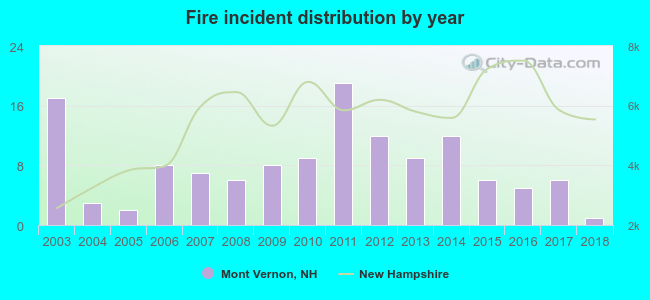 According to the data from the years 2003 - 2018 the average number of fire incidents per year is 8. The highest number of reported fires - 19 took place in 2011, and the least - 1 in 2018. The data has a declining trend.
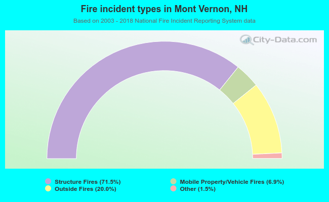 When looking into fire subcategories, the most reports belonged to: Structure Fires (71.5%), and Outside Fires (20.0%).
- 66.2%Fuel oil, kerosene, etc.
- 23.9%Bottled, tank, or LP gas
- 6.7%Wood
- 2.2%Electricity
- 0.6%Utility gas
- 0.3%Coal or coke
- 77.4%Fuel oil, kerosene, etc.
- 11.3%Bottled, tank, or LP gas
- 7.5%Utility gas
- 3.8%Wood
Mont Vernon compared to New Hampshire state average:
- Unemployed percentage below state average.
- Black race population percentage below state average.
- Hispanic race population percentage below state average.
- Foreign-born population percentage significantly below state average.
- Renting percentage significantly below state average.
- Length of stay since moving in significantly above state average.
- Number of rooms per house significantly below state average.
- House age significantly below state average.

|
|
Total of 75 patent applications in 2008-2024.