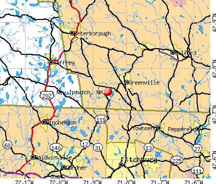
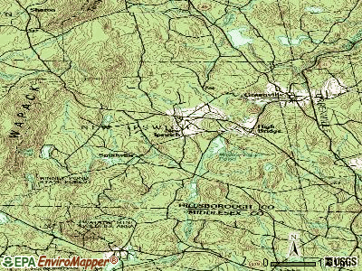
New Ipswich, New Hampshire
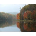
New Ipswich: Flood control Dam doing what it was designed to do
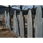
New Ipswich: Smithville Graveyard (one of villages that comprise New Ipswich)
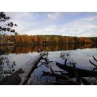
New Ipswich: River rd NEw ipswich nh
- add
your


Submit your own pictures of this town and show them to the world
- OSM Map
- General Map
- Google Map
- MSN Map
Population change since 2000: +18.9%
 |
| Males: 2,609 | |
| Females: 2,490 |
| Median resident age: | 36.5 years |
| New Hampshire median age: | 43.9 years |
Zip codes: 03071.
| New Ipswich: | $97,929 |
| NH: | $89,992 |
Estimated per capita income in 2022: $40,305 (it was $20,210 in 2000)
New Ipswich town income, earnings, and wages data
Estimated median house or condo value in 2022: $362,991 (it was $120,700 in 2000)
| New Ipswich: | $362,991 |
| NH: | $384,700 |
Mean prices in 2022: all housing units: $411,252; detached houses: $441,251; townhouses or other attached units: $283,002; in 2-unit structures: $347,377; in 3-to-4-unit structures: $666,663; in 5-or-more-unit structures: $275,798; mobile homes: $132,093
Detailed information about poverty and poor residents in New Ipswich, NH
Compare current foreclosures near New Ipswich, NH:
| Photo | Address | Area | Beds / Baths | Price | Details |
|---|---|---|---|---|---|

|
#1
Iriquois Dr
Ashburnham, MA 01430
|
2,016 sq. feet
|
2 baths 3 beds |
$369,000
|
show details |

|
#2
Parker St
Gardner, MA 01440
|
1,980 sq. feet
|
2 baths 4 beds |
$469,900
|
show details |

|
#3
Pearl Hill Rd
Fitchburg, MA 01420
|
2,152 sq. feet
|
2 baths 3 beds |
$529,900
|
show details |

|
#4
Nashua St
Milford, NH 03055
|
2,172 sq. feet
|
2 baths 4 beds |
show details | |

|
#5
Amherst St
Amherst, NH 03031
|
- sq. feet
|
4 baths 3 beds |
show details | |

|
#6
Grove Ave
Leominster, MA 01453
|
3,097 sq. feet
|
1 baths 4 beds |
show details | |

|
#7
West Rd
Ashby, MA 01431
|
7,000 sq. feet
|
3 baths 10 beds |
show details | |

|
#8
Russell Ave
Troy, NH 03465
|
2,046 sq. feet
|
1 baths 3 beds |
show details | |

|
#9
Juniper Dr
Amherst, NH 03031
|
3,364 sq. feet
|
4 baths 4 beds |
show details | |

|
#10
Hemlock Dr
Lunenburg, MA 01462
|
696 sq. feet
|
1 baths 2 beds |
show details |
| Photo | Address | Area | Beds / Baths | Price | Details |
|---|---|---|---|---|---|

|
#11
Orchard Ln
Templeton, MA 01468
|
1,176 sq. feet
|
1 baths 3 beds |
show details | |

|
#12
Clyde St
Fitchburg, MA 01420
|
2,028 sq. feet
|
3 baths 4 beds |
show details | |

|
#13
Hollis St
Pepperell, MA 01463
|
1,242 sq. feet
|
1 baths 3 beds |
show details | |

|
#14
Mill St
Greenville, NH 03048
|
1,201 sq. feet
|
2 baths 2 beds |
show details | |

|
#15
W Street Ter
Lunenburg, MA 01462
|
1,232 sq. feet
|
1 baths 2 beds |
show details | |

|
#16
Bickford Hill Rd
Gardner, MA 01440
|
1,320 sq. feet
|
2 baths 3 beds |
show details | |

|
#17
Mallard Dr # 59
Fitchburg, MA 01420
|
1,093 sq. feet
|
1 baths 2 beds |
show details | |

|
#18
Willis Rd
Gardner, MA 01440
|
2,451 sq. feet
|
2 baths 3 beds |
show details | |

|
#19
Shea St
Fitchburg, MA 01420
|
1,332 sq. feet
|
1 baths 2 beds |
show details | |

|
#20
Green St
Gardner, MA 01440
|
3,156 sq. feet
|
2 baths 4 beds |
show details |
| Photo | Address | Area | Beds / Baths | Price | Details |
|---|---|---|---|---|---|

|
#21
Lakewood Ter
Gardner, MA 01440
|
3,143 sq. feet
|
4 baths 5 beds |
show details | |

|
#22
Leominster Rd
Lunenburg, MA 01462
|
1,195 sq. feet
|
2 baths 3 beds |
show details | |

|
#23
Electric Ave
Lunenburg, MA 01462
|
872 sq. feet
|
1 baths 2 beds |
show details | |

|
#24
South St
Fitchburg, MA 01420
|
1,934 sq. feet
|
2 baths 4 beds |
show details | |

|
#25
Mallard Dr
Fitchburg, MA 01420
|
1,093 sq. feet
|
1 baths 2 beds |
show details | |

|
#26
Mallard 59
Fitchburg, MA 01420
|
1,093 sq. feet
|
1 baths 2 beds |
show details | |

|
#27
Crestview Ln
Westminster, MA 01473
|
1,100 sq. feet
|
1 baths 2 beds |
show details | |

|
#28
Sawyer St
Gardner, MA 01440
|
1,280 sq. feet
|
2 baths 3 beds |
show details | |

|
#29
Leo Dr
Gardner, MA 01440
|
1,206 sq. feet
|
1 baths 3 beds |
show details | |

|
#30
Summer St
Fitchburg, MA 01420
|
4,536 sq. feet
|
3 baths 7 beds |
show details |
| Photo | Address | Area | Beds / Baths | Price | Details |
|---|---|---|---|---|---|

|
#31
South St
Fitchburg, MA 01420
|
3,987 sq. feet
|
2 baths 7 beds |
show details | |

|
#32
Clarendon St
Fitchburg, MA 01420
|
2,488 sq. feet
|
2 baths 4 beds |
show details | |

|
#33
Rebanna Rd
Westminster, MA 01473
|
3,313 sq. feet
|
2 baths 4 beds |
show details | |

|
#34
Old Farm Rd
Leominster, MA 01453
|
2,443 sq. feet
|
2 baths 3 beds |
show details | |

|
#35
Wallingford Rd
Milford, NH 03055
|
2,756 sq. feet
|
2 baths 4 beds |
show details | |

|
#36
Royalston Rd S
Winchendon, MA 01475
|
1,188 sq. feet
|
2 baths 3 beds |
show details | |

|
#37
Hall St
Leominster, MA 01453
|
3,724 sq. feet
|
3 baths 5 beds |
show details | |

|
#38
Mill St
Gardner, MA 01440
|
1,728 sq. feet
|
1 baths 4 beds |
show details | |

|
#39
Whitney St
Gardner, MA 01440
|
2,026 sq. feet
|
2 baths 3 beds |
show details | |

|
#40
Carter Rd
Westminster, MA 01473
|
2,182 sq. feet
|
1 baths 3 beds |
show details |
| Photo | Address | Area | Beds / Baths | Price | Details |
|---|---|---|---|---|---|

|
#41
Edgell St
Gardner, MA 01440
|
4,746 sq. feet
|
2 baths 9 beds |
show details | |

|
#42
Hollis Rd
Lunenburg, MA 01462
|
1,520 sq. feet
|
1 baths 3 beds |
show details | |

|
#43
Narrows R 2
Westminster, MA 01473
|
1,871 sq. feet
|
1 baths 4 beds |
show details | |

|
#44
Countryside Rd
Pepperell, MA 01463
|
1,344 sq. feet
|
1 baths 3 beds |
show details | |

|
#45
Summer St
Gardner, MA 01440
|
1,893 sq. feet
|
2 baths 5 beds |
show details | |

|
#46
Emerald St
Gardner, MA 01440
|
1,428 sq. feet
|
1 baths 2 beds |
show details | |

|
#47
Emerald St
Gardner, MA 01440
|
1,428 sq. feet
|
1 baths 2 beds |
show details | |

|
#48
Courthouse Rd
Amherst, NH 03031
|
1,391 sq. feet
|
1 baths 3 beds |
show details | |

|
#49
Norcross Rd
Royalston, MA 01368
|
1,605 sq. feet
|
3 baths 4 beds |
show details | |

|
Check over 1 million property listings on Foreclosure.com!
|
browse all offers | |||

- 4,91896.5%White alone
- 881.7%Hispanic
- 531.0%Two or more races
- 160.3%Asian alone
- 120.2%Black alone
- 80.2%American Indian alone
- 40.08%Native Hawaiian and Other
Pacific Islander alone
Races in New Ipswich detailed stats: ancestries, foreign born residents, place of birth
According to our research of New Hampshire and other state lists, there were 13 registered sex offenders living in New Ipswich, New Hampshire as of May 21, 2024.
The ratio of all residents to sex offenders in New Ipswich is 392 to 1.
Type |
2009 |
2010 |
2011 |
2012 |
2013 |
2014 |
2015 |
2016 |
2017 |
2018 |
2019 |
2020 |
2021 |
2022 |
|---|---|---|---|---|---|---|---|---|---|---|---|---|---|---|
| Murders (per 100,000) | 0 (0.0) | 0 (0.0) | 0 (0.0) | 0 (0.0) | 0 (0.0) | 0 (0.0) | 0 (0.0) | 0 (0.0) | 0 (0.0) | 0 (0.0) | 0 (0.0) | 0 (0.0) | 0 (0.0) | 0 (0.0) |
| Rapes (per 100,000) | 1 (18.4) | 0 (0.0) | 2 (39.2) | 0 (0.0) | 0 (0.0) | 2 (38.9) | 3 (58.2) | 3 (57.6) | 1 (19.1) | 3 (56.6) | 2 (37.0) | 1 (18.4) | 3 (54.9) | 1 (18.8) |
| Robberies (per 100,000) | 0 (0.0) | 1 (19.6) | 1 (19.6) | 0 (0.0) | 0 (0.0) | 1 (19.5) | 0 (0.0) | 0 (0.0) | 0 (0.0) | 0 (0.0) | 0 (0.0) | 0 (0.0) | 0 (0.0) | 0 (0.0) |
| Assaults (per 100,000) | 1 (18.4) | 0 (0.0) | 1 (19.6) | 0 (0.0) | 2 (39.0) | 2 (38.9) | 5 (96.9) | 4 (76.7) | 1 (19.1) | 4 (75.4) | 1 (18.5) | 1 (18.4) | 0 (0.0) | 0 (0.0) |
| Burglaries (per 100,000) | 13 (239.4) | 19 (372.6) | 10 (195.8) | 7 (136.6) | 18 (350.6) | 10 (194.7) | 9 (174.5) | 11 (211.1) | 14 (266.8) | 12 (226.3) | 4 (74.0) | 3 (55.3) | 2 (36.6) | 2 (37.5) |
| Thefts (per 100,000) | 46 (847.1) | 27 (529.5) | 20 (391.7) | 14 (273.3) | 47 (915.5) | 25 (486.9) | 15 (290.8) | 19 (364.5) | 20 (381.1) | 17 (320.6) | 14 (258.9) | 17 (313.4) | 22 (402.8) | 26 (487.5) |
| Auto thefts (per 100,000) | 3 (55.2) | 5 (98.1) | 3 (58.8) | 1 (19.5) | 1 (19.5) | 1 (19.5) | 4 (77.5) | 0 (0.0) | 3 (57.2) | 2 (37.7) | 2 (37.0) | 1 (18.4) | 1 (18.3) | 6 (112.5) |
| Arson (per 100,000) | 4 (73.7) | 1 (19.6) | 0 (0.0) | 2 (39.0) | 3 (58.4) | 0 (0.0) | 0 (0.0) | 0 (0.0) | 2 (38.1) | 1 (18.9) | 0 (0.0) | 0 (0.0) | 1 (18.3) | 0 (0.0) |
| City-Data.com crime index | 73.5 | 61.0 | 75.2 | 22.1 | 70.5 | 79.5 | 96.0 | 90.8 | 57.5 | 92.0 | 51.8 | 36.3 | 64.1 | 46.1 |
The City-Data.com crime index weighs serious crimes and violent crimes more heavily. Higher means more crime, U.S. average is 246.1. It adjusts for the number of visitors and daily workers commuting into cities.
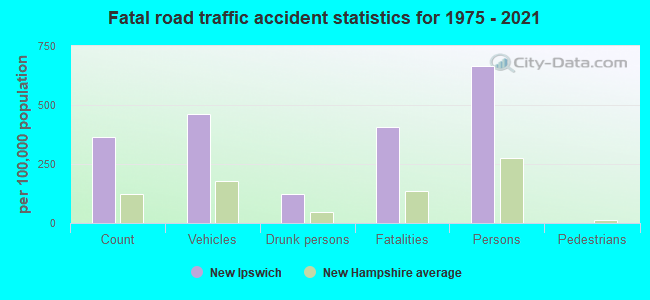
Crime rate in New Ipswich detailed stats: murders, rapes, robberies, assaults, burglaries, thefts, arson
Full-time law enforcement employees in 2021, including police officers: 5 (4 officers - 4 male; 0 female).
| Officers per 1,000 residents here: | 0.73 |
| New Hampshire average: | 2.14 |
 Recent articles from our blog. Our writers, many of them Ph.D. graduates or candidates, create easy-to-read articles on a wide variety of topics.


 | Where to find period, old homes for sale? (20 replies) |
| New Ipswitch? (18 replies) |
| Pipeline and Power line questions (11 replies) |
| New Ipswich, New Boston & Milford (21 replies) |
| Getting ready for the storm. (62 replies) |
| New Hampshire Property Taxes !!!! (182 replies) |
Latest news from New Ipswich, NH collected exclusively by city-data.com from local newspapers, TV, and radio stations
Ancestries: French (17.6%), English (15.2%), Irish (14.6%), French Canadian (9.2%), German (7.4%), Italian (4.8%).
Current Local Time: EST time zone
Incorporated in 1762
Elevation: 1050 feet
Land area: 32.7 square miles.
Population density: 156 people per square mile (very low).
110 residents are foreign born (1.1% North America, 0.9% Europe, 0.4% Latin America).
| This town: | 2.6% |
| New Hampshire: | 4.4% |
| New Ipswich town: | 2.0% ($2,411) |
| New Hampshire: | 2.3% ($2,946) |
Nearest city with pop. 50,000+: Nashua, NH  (19.6 miles , pop. 86,605).
Nearest city with pop. 200,000+: Boston, MA (49.7 miles , pop. 589,141).
Nearest city with pop. 1,000,000+: Bronx, NY (167.6 miles , pop. 1,332,650).
Nearest cities:
), ), Latitude: 42.75 N, Longitude: 71.87 W
Area code commonly used in this area: 603

Single-family new house construction building permits:
- 2022: 20 buildings, average cost: $336,300
- 2021: 23 buildings, average cost: $212,800
- 2020: 20 buildings, average cost: $212,800
- 2019: 20 buildings, average cost: $161,500
- 2018: 19 buildings, average cost: $165,000
- 2017: 19 buildings, average cost: $250,000
- 2016: 15 buildings, average cost: $150,000
- 2015: 17 buildings, average cost: $150,000
- 2014: 23 buildings, average cost: $161,500
- 2013: 6 buildings, average cost: $137,800
- 2012: 5 buildings, average cost: $172,000
- 2011: 9 buildings, average cost: $183,300
- 2010: 8 buildings, average cost: $235,600
- 2009: 7 buildings, average cost: $242,900
- 2008: 16 buildings, average cost: $304,700
- 2007: 43 buildings, average cost: $246,700
- 2006: 34 buildings, average cost: $262,100
- 2005: 53 buildings, average cost: $215,800
- 2004: 24 buildings, average cost: $211,300
- 2003: 26 buildings, average cost: $196,500
- 2002: 70 buildings, average cost: $200,900
- 2001: 62 buildings, average cost: $173,700
- 2000: 71 buildings, average cost: $162,500
- 1999: 26 buildings, average cost: $120,900
- 1998: 19 buildings, average cost: $116,200
- 1997: 14 buildings, average cost: $112,100
| Here: | 2.9% |
| New Hampshire: | 2.5% |
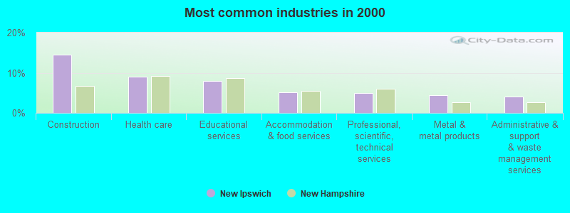
- Construction (14.5%)
- Health care (9.0%)
- Educational services (8.0%)
- Accommodation & food services (5.1%)
- Professional, scientific, technical services (5.0%)
- Metal & metal products (4.5%)
- Administrative & support & waste management services (4.1%)
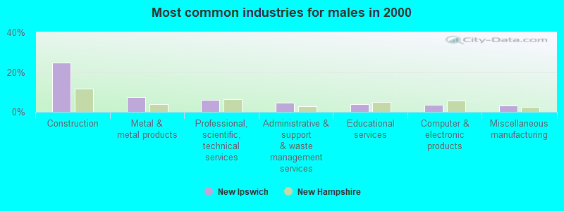
- Construction (24.7%)
- Metal & metal products (7.5%)
- Professional, scientific, technical services (6.1%)
- Administrative & support & waste management services (4.5%)
- Educational services (3.8%)
- Computer & electronic products (3.6%)
- Miscellaneous manufacturing (3.2%)
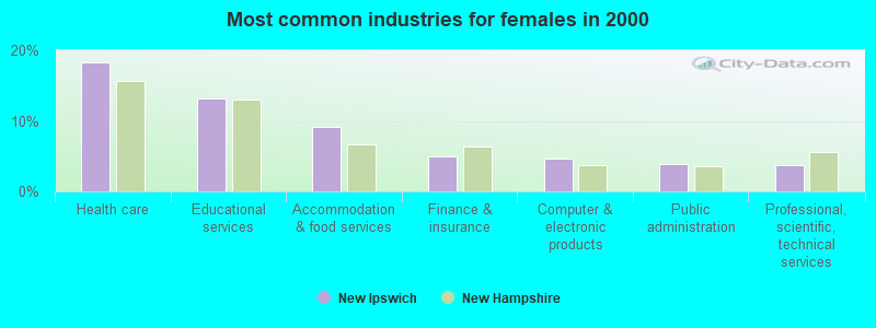
- Health care (18.3%)
- Educational services (13.2%)
- Accommodation & food services (9.2%)
- Finance & insurance (4.9%)
- Computer & electronic products (4.7%)
- Public administration (3.8%)
- Professional, scientific, technical services (3.7%)
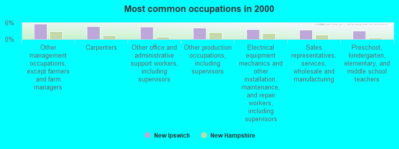
- Other management occupations, except farmers and farm managers (5.6%)
- Carpenters (4.8%)
- Other office and administrative support workers, including supervisors (4.5%)
- Other production occupations, including supervisors (4.3%)
- Electrical equipment mechanics and other installation, maintenance, and repair workers, including supervisors (3.6%)
- Sales representatives, services, wholesale and manufacturing (3.4%)
- Preschool, kindergarten, elementary, and middle school teachers (3.2%)
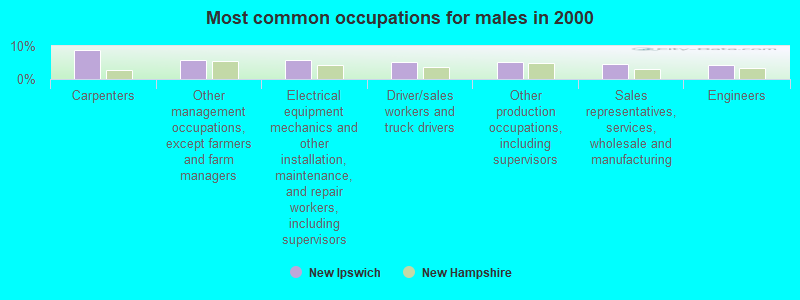
- Carpenters (8.7%)
- Other management occupations, except farmers and farm managers (5.9%)
- Electrical equipment mechanics and other installation, maintenance, and repair workers, including supervisors (5.8%)
- Driver/sales workers and truck drivers (5.2%)
- Other production occupations, including supervisors (5.1%)
- Sales representatives, services, wholesale and manufacturing (4.5%)
- Engineers (4.3%)
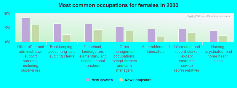
- Other office and administrative support workers, including supervisors (8.5%)
- Bookkeeping, accounting, and auditing clerks (6.5%)
- Preschool, kindergarten, elementary, and middle school teachers (6.3%)
- Other management occupations, except farmers and farm managers (5.3%)
- Assemblers and fabricators (4.7%)
- Information and record clerks, except customer service representatives (4.7%)
- Nursing, psychiatric, and home health aides (4.0%)
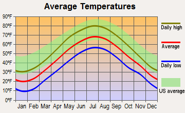
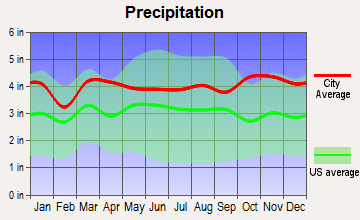
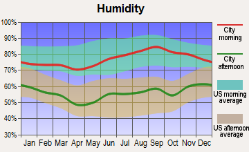
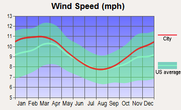
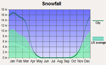
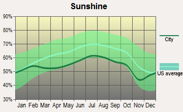
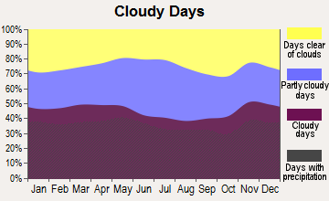
Average climate in New Ipswich, New Hampshire
Based on data reported by over 4,000 weather stations
(lower is better)
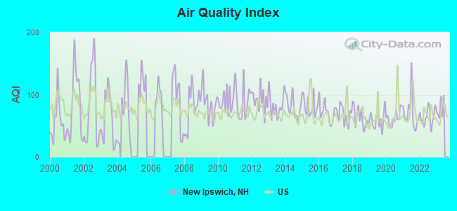
Air Quality Index (AQI) level in 2022 was 64.4. This is about average.
| City: | 64.4 |
| U.S.: | 72.6 |
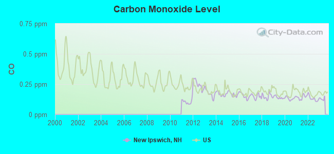
Carbon Monoxide (CO) [ppm] level in 2022 was 0.131. This is significantly better than average. Closest monitor was 7.5 miles away from the city center.
| City: | 0.131 |
| U.S.: | 0.251 |
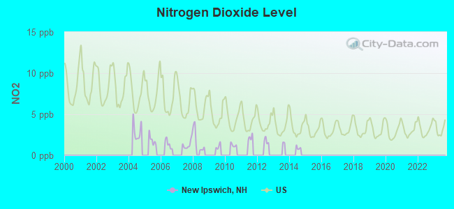
Nitrogen Dioxide (NO2) [ppb] level in 2008 was 1.71. This is significantly better than average. Closest monitor was 7.5 miles away from the city center.
| City: | 1.71 |
| U.S.: | 5.11 |
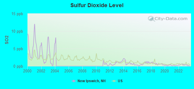
Sulfur Dioxide (SO2) [ppb] level in 2022 was 0.411. This is significantly better than average. Closest monitor was 7.5 miles away from the city center.
| City: | 0.411 |
| U.S.: | 1.515 |
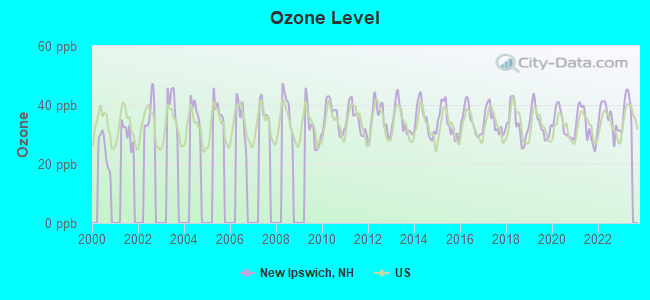
Ozone [ppb] level in 2022 was 35.5. This is about average. Closest monitor was 7.5 miles away from the city center.
| City: | 35.5 |
| U.S.: | 33.3 |
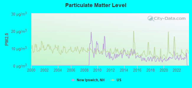
Particulate Matter (PM2.5) [µg/m3] level in 2022 was 4.35. This is significantly better than average. Closest monitor was 7.5 miles away from the city center.
| City: | 4.35 |
| U.S.: | 8.11 |
Tornado activity:
New Ipswich-area historical tornado activity is above New Hampshire state average. It is 23% smaller than the overall U.S. average.
On 6/9/1953, a category F4 (max. wind speeds 207-260 mph) tornado 25.0 miles away from the New Ipswich town center killed 90 people and injured 1228 people and caused between $50,000,000 and $500,000,000 in damages.
On 6/22/1981, a category F3 (max. wind speeds 158-206 mph) tornado 14.2 miles away from the town center injured 3 people and caused between $5000 and $50,000 in damages.
Earthquake activity:
New Ipswich-area historical earthquake activity is significantly above New Hampshire state average. It is 71% smaller than the overall U.S. average.On 10/7/1983 at 10:18:46, a magnitude 5.3 (5.1 MB, 5.3 LG, 5.1 ML, Class: Moderate, Intensity: VI - VII) earthquake occurred 149.6 miles away from the city center
On 4/20/2002 at 10:50:47, a magnitude 5.3 (5.3 ML, Depth: 3.0 mi) earthquake occurred 152.3 miles away from the city center
On 4/20/2002 at 10:50:47, a magnitude 5.2 (5.2 MB, 4.2 MS, 5.2 MW, 5.0 MW) earthquake occurred 151.5 miles away from the city center
On 1/19/1982 at 00:14:42, a magnitude 4.7 (4.5 MB, 4.7 MD, 4.5 LG, Class: Light, Intensity: IV - V) earthquake occurred 53.3 miles away from New Ipswich center
On 10/16/2012 at 23:12:25, a magnitude 4.7 (4.7 ML, Depth: 10.0 mi) earthquake occurred 84.5 miles away from New Ipswich center
On 10/2/1994 at 11:27:22, a magnitude 3.7 (3.5 LG, 3.7 LG, Depth: 6.2 mi, Class: Light, Intensity: II - III) earthquake occurred 35.0 miles away from the city center
Magnitude types: regional Lg-wave magnitude (LG), body-wave magnitude (MB), duration magnitude (MD), local magnitude (ML), surface-wave magnitude (MS), moment magnitude (MW)
Natural disasters:
The number of natural disasters in Hillsborough County (27) is a lot greater than the US average (15).Major Disasters (Presidential) Declared: 17
Emergencies Declared: 10
Causes of natural disasters: Storms: 13, Floods: 11, Winter Storms: 5, Snowstorms: 4, Hurricanes: 3, Snows: 3, Blizzard: 1, Ice Storm: 1, Snowfall: 1, Wind: 1 (Note: some incidents may be assigned to more than one category).
Hospitals and medical centers near New Ipswich:
- NAUKEAG HOSPITAL CORPORATION (Hospital, about 8 miles away; ASHBURNHAM, MA)
- GOOD SHEPHERD REHABILITATION AND NURSING CENTER (Nursing Home, about 9 miles away; JAFFREY, NH)
- MONADNOCK COMMUNITY HOSPITAL Critical Access Hospitals (about 10 miles away; PETERBOROUGH, NH)
- WACHUSETT MANOR NURSING HOME (Nursing Home, about 11 miles away; GARDNER, MA)
- PHEASANT WOOD CARE AND REHABILIATION CENTER (Nursing Home, about 12 miles away; PETERBOROUGH, NH)
- HIGHLANDS, THE (Nursing Home, about 12 miles away; FITCHBURG, MA)
- BIRCHWOOD MANOR NURS HOME (Nursing Home, about 12 miles away; FITCHBURG, MA)
Colleges/universities with over 2000 students nearest to New Ipswich:
- Franklin Pierce University (about 10 miles; Rindge, NH; Full-time enrollment: 2,139)
- Fitchburg State University (about 13 miles; Fitchburg, MA; FT enrollment: 5,010)
- Mount Wachusett Community College (about 13 miles; Gardner, MA; FT enrollment: 3,143)
- Keene State College (about 25 miles; Keene, NH; FT enrollment: 5,098)
- Saint Anselm College (about 25 miles; Manchester, NH; FT enrollment: 2,059)
- Mount Washington College (about 26 miles; Manchester, NH; FT enrollment: 2,187)
- University of Massachusetts-Lowell (about 29 miles; Lowell, MA; FT enrollment: 12,341)
Public high school in New Ipswich:
- MASCENIC REGIONAL HIGH SCHOOL (Students: 404, Location: 175 TURNPIKE RD., Grades: 9-12)
Public elementary/middle schools in New Ipswich:
- BOYNTON MIDDLE SCHOOL (Students: 483, Location: 500 TURNPIKE RD., Grades: 5-8)
- HIGHBRIDGE HILL ELEMENTARY SCHOOL (Location: 171 TURNPIKE ROAD, Grades: PK-4)
Points of interest:
Notable locations in New Ipswich: Sleeping Monk Farm (A), Windblown Ski Touring Center (B), Souhegan Valley Ambulance (C), New Ipswich Volunteer Fire Department (D). Display/hide their locations on the map
Churches in New Ipswich include: New Ipswich Congregational Church (A), Apostolic Church (B), Our Redeemer Chapel (C). Display/hide their locations on the map
Cemeteries: Smithville Cemetery (1), Village Cemetery (2), Sacred Heart Cemetery (3). Display/hide their locations on the map
Lakes, reservoirs, and swamps: Binney Pond (A), Gibson Pond (B), Hoar Pond (C), Wheeler Pond (D), Souhegan River Reservoir Number 13 (E), Smithville Reservoir (F), Souhegan River Watershed Reservoir Number 13 (G), Mountain Pond (H). Display/hide their locations on the map
Streams, rivers, and creeks: Stark Brook (A), West Branch Souhegan River (B), Pratt Pond Brook (C), West Souhegan River (D), Furnace Brook (E), Fox Brook (F), South Branch Souhegan River (G). Display/hide their locations on the map
Parks in New Ipswich include: Marshall State Forest (1), Binney Pond State Forest (2). Display/hide their locations on the map
Tourist attraction: Barrett House (Museums; 79 Main Street) (1). Display/hide its approximate location on the map
Birthplace of: Benjamin Champney - Artist, Nathan Brown (missionary) - Abolitionist, Rodney Wallace (Massachusetts) - Politician.
Drinking water stations with addresses in New Ipswich and their reported violations in the past:
FOXGLOVE APARTMENTS (Serves MA, Population served: 25, Groundwater):Past monitoring violations:
- 3 regular monitoring violations
| This town: | 2.9 people |
| New Hampshire: | 2.5 people |
| This town: | 75.1% |
| Whole state: | 66.3% |
| This town: | 8.1% |
| Whole state: | 8.3% |
Likely homosexual households (counted as self-reported same-sex unmarried-partner households)
- Lesbian couples: 0.2% of all households
- Gay men: 0.4% of all households
| This town: | 7.1% |
| Whole state: | 6.5% |
| This town: | 1.7% |
| Whole state: | 2.8% |
19 people in other noninstitutional group quarters in 2000
4 people in religious group quarters in 2000
Banks with branches in New Ipswich (2011 data):
- TD Bank, National Association: New Ipswich Branch at 564 Turnpike Road, branch established on 1976/02/17. Info updated 2010/10/04: Bank assets: $188,912.6 mil, Deposits: $153,149.8 mil, headquarters in Wilmington, DE, positive income, 1314 total offices, Holding Company: Toronto-Dominion Bank, The
For population 15 years and over in New Ipswich:
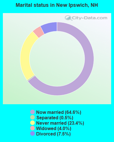
- Never married: 23.4%
- Now married: 64.6%
- Separated: 0.5%
- Widowed: 4.0%
- Divorced: 7.5%
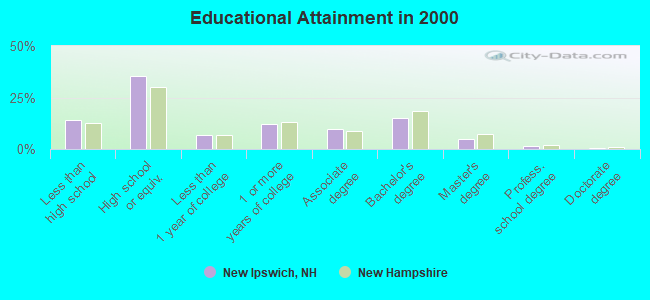
For population 25 years and over in New Ipswich:
- High school or higher: 86.1%
- Bachelor's degree or higher: 22.1%
- Graduate or professional degree: 6.9%
- Unemployed: 2.6%
- Mean travel time to work (commute): 34.1 minutes
| Here: | 10.2 |
| New Hampshire average: | 10.9 |


Graphs represent county-level data. Detailed 2008 Election Results
Religion statistics for New Ipswich, NH (based on Hillsborough County data)


| Religion | Adherents | Congregations |
|---|---|---|
| Catholic | 124,993 | 40 |
| Evangelical Protestant | 20,588 | 103 |
| Mainline Protestant | 17,794 | 60 |
| Other | 7,365 | 35 |
| Orthodox | 2,990 | 7 |
| Black Protestant | - | 1 |
| None | 226,991 | - |
Food Environment Statistics:
| Hillsborough County: | 1.82 / 10,000 pop. |
| State: | 2.14 / 10,000 pop. |
| This county: | 0.12 / 10,000 pop. |
| New Hampshire: | 0.15 / 10,000 pop. |
| Hillsborough County: | 1.65 / 10,000 pop. |
| State: | 1.78 / 10,000 pop. |
| Hillsborough County: | 2.67 / 10,000 pop. |
| New Hampshire: | 4.02 / 10,000 pop. |
| Here: | 8.23 / 10,000 pop. |
| New Hampshire: | 9.70 / 10,000 pop. |
| Hillsborough County: | 6.9% |
| State: | 7.6% |
| This county: | 24.5% |
| New Hampshire: | 24.4% |
| Here: | 15.1% |
| State: | 15.9% |
6.73% of this county's 2021 resident taxpayers lived in other counties in 2020 ($92,767 average adjusted gross income)
| Here: | 6.73% |
| New Hampshire average: | 7.66% |
0.01% of residents moved from foreign countries ($183 average AGI)
Hillsborough County: 0.01% New Hampshire average: 0.01%
Top counties from which taxpayers relocated into this county between 2020 and 2021:
| from Middlesex County, MA | |
| from Rockingham County, NH | |
| from Merrimack County, NH |
6.49% of this county's 2020 resident taxpayers moved to other counties in 2021 ($81,100 average adjusted gross income)
| Here: | 6.49% |
| New Hampshire average: | 6.80% |
0.02% of residents moved to foreign countries ($105 average AGI)
Hillsborough County: 0.02% New Hampshire average: 0.01%
Top counties to which taxpayers relocated from this county between 2020 and 2021:
| to Rockingham County, NH | |
| to Merrimack County, NH | |
| to Middlesex County, MA |
Strongest AM radio stations in New Ipswich:
- WRKO (680 AM; 50 kW; BOSTON, MA; Owner: ENTERCOM BOSTON LICENSE, LLC)
- WCRN (830 AM; 50 kW; WORCESTER, MA; Owner: CARTER BROADCASTING CORPORATION)
- WEIM (1280 AM; 5 kW; FITCHBURG, MA; Owner: LIVEAIR COMMUNICATIONS, INC.)
- WEEI (850 AM; 50 kW; BOSTON, MA; Owner: ENTERCOM BOSTON LICENSE, LLC)
- WKOX (1200 AM; 50 kW; FRAMINGHAM, MA; Owner: CAPSTAR TX LIMITED PARTNERSHIP)
- WBIX (1060 AM; 40 kW; NATICK, MA; Owner: LANGER BROADCASTING CORPORATION)
- WVNE (760 AM; daytime; 25 kW; LEICESTER, MA; Owner: BLOUNT MASSCOM, INC.)
- WNNZ (640 AM; 50 kW; WESTFIELD, MA; Owner: CLEAR CHANNEL BROADCASTING LICENSES, INC.)
- WFGL (960 AM; 2 kW; FITCHBURG, MA; Owner: CSN INTERNATIONAL)
- WWZN (1510 AM; 50 kW; BOSTON, MA; Owner: ROSE CITY RADIO CORPORATION)
- WAMG (890 AM; 25 kW; DEDHAM, MA; Owner: MEGA COMMUNICATIONS OF DEDHAM LICENSEE, LLC)
- WALE (990 AM; 50 kW; GREENVILLE, RI; Owner: NORTH AMERICAN BROADCASTING CO., INC.)
- WBZ (1030 AM; 50 kW; BOSTON, MA; Owner: INFINITY BROADCASTING OPERATIONS, INC.)
Strongest FM radio stations in New Ipswich:
- WFEX (92.1 FM; PETERBOROUGH, NH; Owner: FNX BROADCASTING OF NEW HAMPSHIRE LLC)
- WINQ (97.7 FM; WINCHENDON, MA; Owner: SAGA COMMUNICATIONS OF NEW ENGLAND, LLC)
- WGIR-FM (101.1 FM; MANCHESTER, NH; Owner: CAPSTAR TX LIMITED PARTNERSHIP)
- WQLL (96.5 FM; BEDFORD, NH; Owner: SAGA COMMUNICATIONS OF NEW ENGLAND, LLC)
- WLMW (90.7 FM; MANCHESTER, NH; Owner: KNOWLEDGE FOR LIFE)
- WZID (95.7 FM; MANCHESTER, NH; Owner: SAGA COMMUNICATIONS OF NEW ENGLAND, LLC)
- WXLO (104.5 FM; FITCHBURG, MA; Owner: CITADEL BROADCASTING COMPANY)
- WHDQ (106.1 FM; CLAREMONT, NH; Owner: GREAT NORTHERN RADIO, L.L.C.)
- WAAF (107.3 FM; WORCESTER, MA; Owner: ENTERCOM BOSTON LICENSE, LLC)
- WVPR (89.5 FM; WINDSOR, VT; Owner: VERMONT PUBLIC RADIO)
- WTPL (107.7 FM; HILLSBORO, NH; Owner: CONCORD BROADCASTING, L.L.C.)
- WKNE (103.7 FM; KEENE, NH; Owner: SAGA COMMUNICATIONS OF NEW ENGLAND, LLC)
- WEVN (90.7 FM; KEENE, NH; Owner: NEW HAMPSHIRE PUBLIC RADIO, INC.)
- WSRS (96.1 FM; WORCESTER, MA; Owner: CAPSTAR TX LIMITED PARTNERSHIP)
- WEQX (102.7 FM; MANCHESTER, VT; Owner: NORTHSHIRE COMMUNICATIONS, INC.)
- WAHL (99.9 FM; ATHOL, MA; Owner: CITADEL BROADCASTING COMPANY)
- WHOB (106.3 FM; NASHUA, NH; Owner: TELE-MEDIA COMPANY OF NEW HAMPSHIRE, L.L.C.)
- WNNH (99.1 FM; HENNIKER, NH; Owner: TELE-MEDIA COMPANY OF NEW HAMPSHIRE, L.L.C.)
- WOQL (98.7 FM; WINCHESTER, NH; Owner: SAGA COMMUNICATIONS OF NEW HAMPSHIRE, LLC)
- WBMX (98.5 FM; BOSTON, MA; Owner: INFINITY RADIO OPERATIONS INC.)
TV broadcast stations around New Ipswich:
- WUNI (Channel 27; WORCESTER, MA; Owner: ENTRAVISION HOLDINGS, LLC)
- WUTF (Channel 66; MARLBOROUGH, MA; Owner: TELEFUTURA BOSTON LLC)
- WCVB-TV (Channel 5; BOSTON, MA; Owner: WCVB HEARST-ARGYLE TV, INC.)
- WGBH-TV (Channel 2; BOSTON, MA; Owner: WGBH EDUCATIONAL FOUNDATION)
- WHDH-TV (Channel 7; BOSTON, MA; Owner: WHDH-TV)
- WMFP (Channel 62; LAWRENCE, MA; Owner: WSAH LICENSE, INC.)
- WBZ-TV (Channel 4; BOSTON, MA; Owner: VIACOM INC.)
- WGBX-TV (Channel 44; BOSTON, MA; Owner: WGBH EDUCATIONAL FOUNDATION)
- WSBK-TV (Channel 38; BOSTON, MA; Owner: VIACOM INC.)
- WLVI-TV (Channel 56; CAMBRIDGE, MA; Owner: WLVI, INC.)
- WFXZ-CA (Channel 24; BOSTON, MA; Owner: BOSTON BROADCASTING CORP.)
- WYDN (Channel 48; WORCESTER, MA; Owner: EDUCATIONAL PUBLIC TV CORPORATION)
- WFXT (Channel 25; BOSTON, MA; Owner: FOX TELEVISION STATIONS INC.)
- WNDS (Channel 50; DERRY, NH; Owner: CTV OF DERRY, INC)
- National Bridge Inventory (NBI) Statistics
- 6Number of bridges
- 33ft / 10.0mTotal length
- $18,852,000Total costs
- 8,924Total average daily traffic
- 418Total average daily truck traffic
- 13,204Total future (year 2042) average daily traffic
FCC Registered Antenna Towers:
1- Anthony Handley, North Of Old Rindge Road & Old Peterborough Road (Lat: 42.772111 Lon: -71.892667), Type: 53.6, Structure height: 33011 m, Overall height: 51.8 m, Registrant: Blue Sky Towers Iii, LLC, Chuck.Laurette@blueskytower.Com, Suite 106, North- Reading, Phone: (888) 960-7958
FCC Registered Broadcast Land Mobile Towers:
2- Jct Rt 123 & 124 (Lat: 42.754528 Lon: -71.831472), Call Sign: KNDD663,
Assigned Frequencies: 151.655 MHz, Grant Date: 09/09/2002, Expiration Date: 09/08/2012, Cancellation Date: 11/10/2012, Registrant: Universal Licensing Service, 3419 Via Lido 609, Newport Beach, CA 92663, Phone: (877) 677-3639, Fax: (949) 515-2544
- 15 Main Street (Lat: 42.763056 Lon: -71.859389), Type: Building, Structure height: 6 m, Overall height: 12.1 m, Call Sign: WPZX309,
Assigned Frequencies: 154.650 MHz, Grant Date: 01/18/2014, Expiration Date: 04/01/2024, Cancellation Date: 10/26/2022, Certifier: Peter M Flood, Registrant: Hillsborough County Sheriff, 329 Mast Raod, Goffstown, NH 03045, Phone: (603) 627-0168, Fax: (603) 627-5634, Email:
FCC Registered Amateur Radio Licenses:
88 (See the full list of FCC Registered Amateur Radio Licenses in New Ipswich)FAA Registered Aircraft:
8 (See the full list of FAA Registered Aircraft in New Ipswich)2002 - 2018 National Fire Incident Reporting System (NFIRS) incidents
- Fire incident types reported to NFIRS in New Ipswich, NH
- 19448.0%Structure Fires
- 15037.1%Outside Fires
- 338.2%Mobile Property/Vehicle Fires
- 276.7%Other
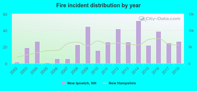 Based on the data from the years 2002 - 2018 the average number of fire incidents per year is 24. The highest number of reported fire incidents - 52 took place in 2014, and the least - 1 in 2005. The data has a growing trend.
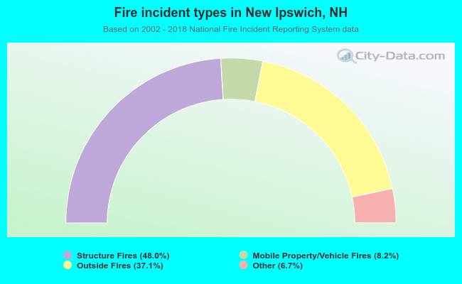 When looking into fire subcategories, the most incidents belonged to: Structure Fires (48.0%), and Outside Fires (37.1%).
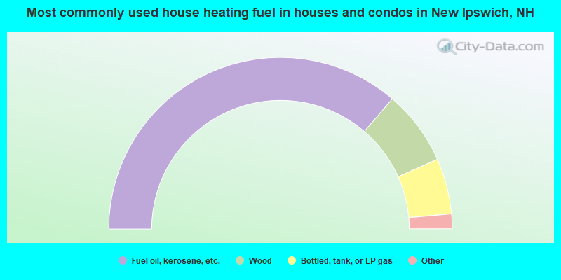
- 72.6%Fuel oil, kerosene, etc.
- 14.1%Wood
- 10.5%Bottled, tank, or LP gas
- 1.0%Utility gas
- 1.0%Electricity
- 0.5%Other fuel
- 0.3%Solar energy
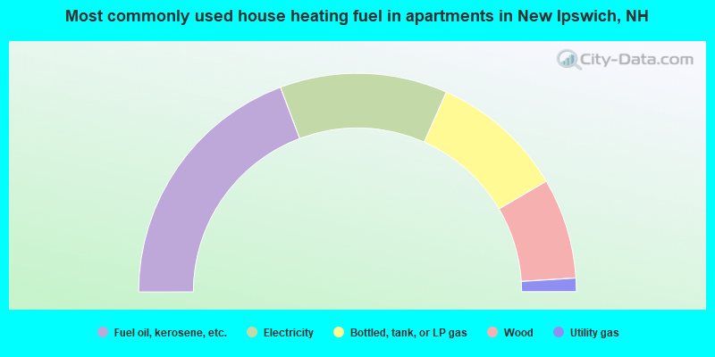
- 38.6%Fuel oil, kerosene, etc.
- 24.8%Electricity
- 19.8%Bottled, tank, or LP gas
- 14.9%Wood
- 2.0%Utility gas
New Ipswich compared to New Hampshire state average:
- Unemployed percentage significantly below state average.
- Black race population percentage significantly below state average.
- Hispanic race population percentage below state average.
- Median age below state average.
- Foreign-born population percentage significantly below state average.
- Renting percentage below state average.
- Length of stay since moving in significantly above state average.
- Number of rooms per house significantly below state average.
- House age significantly below state average.
New Ipswich on our top lists:
- #4 on the list of "Top 101 cities with largest percentage of males in occupations: carpenters (population 5,000+)"
- #9 on the list of "Top 101 cities with largest percentage of females in occupations: special education teachers (population 5,000+)"
- #14 on the list of "Top 101 cities with largest percentage of females in occupations: bookkeeping, accounting, and auditing clerks (population 5,000+)"
- #25 on the list of "Top 101 cities with the lowest number of assaults per 100,000 residents (population 5,000+)"
- #29 on the list of "Top 101 cities with the lowest number of police officers per 1000 residents (population 5,000+)"
- #29 on the list of "Top 101 cities with largest percentage of males in industries: paper and paper products merchant wholesalers (population 5,000+)"
- #30 on the list of "Top 101 cities with largest percentage of females in occupations: assemblers and fabricators (population 5,000+)"
- #33 on the list of "Top 101 cities with the lowest city-data.com crime index (population 5,000+)"
- #39 on the list of "Top 101 cities with largest percentage of females in occupations: motor vehicle operators except bus and truck drivers (population 5,000+)"
- #40 on the list of "Top 101 cities with largest percentage of females in occupations: religious workers (population 5,000+)"
- #45 on the list of "Top 101 cities with the lowest number of thefts per 100,000 residents (population 5,000+)"
- #45 on the list of "Top 101 cities with largest percentage of females in industries: printing and related support activities (population 5,000+)"
- #49 on the list of "Top 101 cities with largest percentage of males in industries: electronic shopping and mail-order houses (population 5,000+)"
- #56 on the list of "Top 101 cities with largest percentage of males in industries: metal and metal products (population 5,000+)"
- #61 on the list of "Top 101 cities with largest percentage of females in industries: other transportation, and support activities, and couriers (population 5,000+)"
- #63 on the list of "Top 101 cities with largest percentage of females in industries: computer and electronic products (population 5,000+)"
- #71 on the list of "Top 101 cities with largest percentage of females in industries: beverage and tobacco products (population 5,000+)"
- #74 on the list of "Top 101 cities with largest percentage of males in industries: retail florists (population 5,000+)"
- #75 on the list of "Top 101 cities with largest percentage of females in industries: electrical and electronic goods merchant wholesalers (population 5,000+)"
- #85 on the list of "Top 101 cities with largest percentage of males in industries: machinery, equipment, and supplies merchant wholesalers (population 5,000+)"
- #6 on the list of "Top 101 counties with the lowest Particulate Matter (PM10) Annual air pollution readings in 2012 (µg/m3)"
- #12 on the list of "Top 101 counties with the lowest Particulate Matter (PM2.5) Annual air pollution readings in 2012 (µg/m3)"
- #15 on the list of "Top 101 counties with the lowest number of infant deaths per 1000 residents 2007-2013 (pop. 50,000+)"
- #24 on the list of "Top 101 counties with the largest decrease in the number of infant deaths per 1000 residents 2000-2006 to 2007-2013 (pop. 50,000+)"
- #44 on the list of "Top 101 counties with the lowest Nitrogen Dioxide air pollution readings in 2012 (ppm)"

|
|
Total of 111 patent applications in 2008-2024.