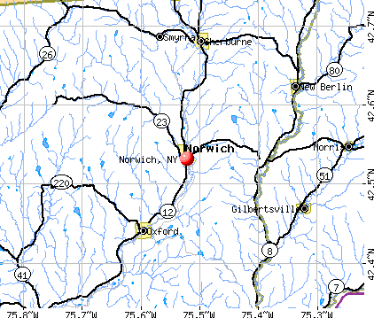
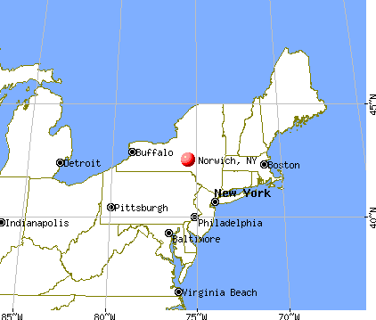
Norwich, New York
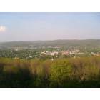
Norwich: View of Norwich, NY from atop the quarry
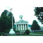
Norwich: Chenango County Court House Norwich NY
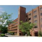
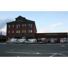
Norwich: Eaton Ctr Office Building Norwich NY
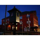
Norwich: Norwich at Night
Norwich: Norwich Fire House
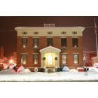
Norwich: Norwich Police Station Christmas Eve 2008
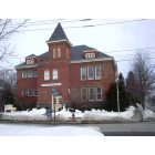
Norwich: birdsall st schooll former school building
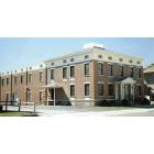
Norwich: City of Norwich Police Headquarters
- add
your
Submit your own pictures of this city and show them to the world
- OSM Map
- General Map
- Google Map
- MSN Map
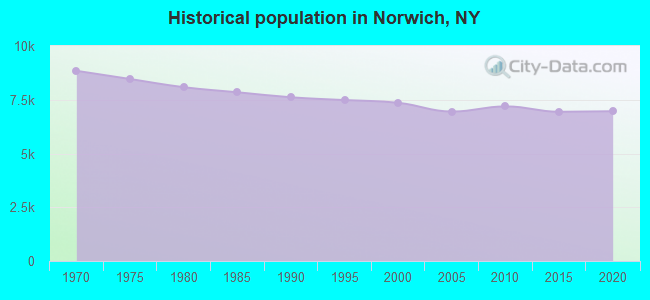
Population change since 2000: -7.4%
 |
| Males: 3,158 | |
| Females: 3,654 |
| Median resident age: | 41.2 years |
| New York median age: | 40.0 years |
Zip codes: 13815.
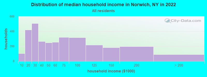
| Norwich: | $49,442 |
| NY: | $79,557 |
Estimated per capita income in 2022: $32,798 (it was $17,339 in 2000)
Norwich city income, earnings, and wages data
Estimated median house or condo value in 2022: $120,193 (it was $60,100 in 2000)
| Norwich: | $120,193 |
| NY: | $400,400 |
Mean prices in 2022: all housing units: $153,408; detached houses: $176,469; townhouses or other attached units: $221,795; in 2-unit structures: $202,304; in 3-to-4-unit structures: $170,454; in 5-or-more-unit structures: $957,530; mobile homes: $68,668; occupied boats, rvs, vans, etc.: $114,445
Median gross rent in 2022: $824.
(19.1% for White Non-Hispanic residents, 22.1% for Black residents, 4.9% for Hispanic or Latino residents, 100.0% for American Indian residents, 4.2% for other race residents, 8.8% for two or more races residents)
Detailed information about poverty and poor residents in Norwich, NY

Compare current foreclosures near Norwich, NY:
| Photo | Address | Area | Beds / Baths | Price | Details |
|---|---|---|---|---|---|

|
#1
Henry St
Norwich, NY 13815
|
2,560 sq. feet
|
1 baths 3 beds |
$17,900
|
show details |

|
#2
County Road 10
Norwich, NY 13815
|
1,572 sq. feet
|
1 baths 5 beds |
$15,900
|
show details |

|
#3
County Road 31
Norwich, NY 13815
|
1,872 sq. feet
|
1 baths 6 beds |
show details | |

|
#4
County Road 29
Norwich, NY 13815
|
2,576 sq. feet
|
2 baths 3 beds |
show details | |

|
#5
Francis Ave
Norwich, NY 13815
|
1,506 sq. feet
|
1 baths 3 beds |
show details | |

|
#6
Birdsall St
Norwich, NY 13815
|
1,407 sq. feet
|
2 baths 3 beds |
show details | |

|
#7
County Road 31
Norwich, NY 13815
|
1,872 sq. feet
|
1 baths 3 beds |
show details | |

|
#8
Collier Ln
Norwich, NY 13815
|
- sq. feet
|
- baths - beds |
show details | |

|
#9
Beale St
Norwich, NY 13815
|
- sq. feet
|
- baths - beds |
show details | |

|
#10
Jones Ave
Norwich, NY 13815
|
- sq. feet
|
- baths - beds |
show details |
| Photo | Address | Area | Beds / Baths | Price | Details |
|---|---|---|---|---|---|

|
#11
County Road 34
Norwich, NY 13815
|
280 sq. feet
|
- baths - beds |
show details | |

|
#12
County Road 29
Norwich, NY 13815
|
960 sq. feet
|
- baths - beds |
show details | |

|
#13
Old State Highway 23 # 23
South Plymouth, NY 13844
|
1,196 sq. feet
|
2 baths 3 beds |
$25,900
|
show details |

|
#14
Scott St
Oxford, NY 13830
|
2,840 sq. feet
|
2 baths 4 beds |
show details | |

|
#15
Maple Street
Gilbertsville, NY 13776
|
2,612 sq. feet
|
2 baths 4 beds |
show details | |

|
#16
Pearl St W
Sidney, NY 13838
|
720 sq. feet
|
1 baths 2 beds |
show details | |

|
#17
State Highway 8
South New Berlin, NY 13843
|
2,424 sq. feet
|
1 baths 3 beds |
show details | |

|
#18
New Virginia Rd
Oxford, NY 13830
|
912 sq. feet
|
1 baths 4 beds |
show details | |

|
#19
Freiot Ave
Bainbridge, NY 13733
|
2,004 sq. feet
|
1 baths 3 beds |
show details | |

|
#20
Rexford Falls Rd
Sherburne, NY 13460
|
3,124 sq. feet
|
2 baths 4 beds |
show details |
| Photo | Address | Area | Beds / Baths | Price | Details |
|---|---|---|---|---|---|

|
#21
Race Rd
Greene, NY 13778
|
1,600 sq. feet
|
2 baths 2 beds |
show details | |

|
#22
County Road 16
Plymouth, NY 13832
|
1,600 sq. feet
|
1 baths 3 beds |
show details | |

|
#23
Creek Rd
Mc Donough, NY 13801
|
1,217 sq. feet
|
1 baths 3 beds |
show details | |

|
#24
Tracy Rd
Sherburne, NY 13460
|
- sq. feet
|
- baths 3 beds |
show details | |

|
#25
Pratt Lane
Oxford, NY 13830
|
- sq. feet
|
- baths - beds |
show details | |

|
#26
County Highway 1b
Mount Upton, NY 13809
|
- sq. feet
|
- baths - beds |
show details | |

|
#27
Oak Ave
Sidney, NY 13838
|
- sq. feet
|
- baths - beds |
show details | |

|
#28
State Highway 206
Bainbridge, NY 13733
|
- sq. feet
|
- baths - beds |
show details | |

|
#29
Meadow Ln
South New Berlin, NY 13843
|
- sq. feet
|
- baths - beds |
show details | |

|
#30
S Hamilton Rd
Earlville, NY 13332
|
2,016 sq. feet
|
- baths - beds |
show details |
| Photo | Address | Area | Beds / Baths | Price | Details |
|---|---|---|---|---|---|

|
#31
Card Rd
Edmeston, NY 13335
|
- sq. feet
|
- baths - beds |
show details | |

|
#32
Bingham Collins Rd
Sherburne, NY 13460
|
600 sq. feet
|
- baths - beds |
show details | |

|
#33
Rican Ln
Mount Upton, NY 13809
|
- sq. feet
|
- baths - beds |
show details | |

|
#34
Cross Road
Gilbertsville, NY 13776
|
- sq. feet
|
- baths - beds |
show details | |

|
#35
State Highway 23 # 23
South New Berlin, NY 13843
|
- sq. feet
|
- baths - beds |
show details | |

|
#36
State Highway 51
Morris, NY 13808
|
- sq. feet
|
- baths - beds |
show details | |

|
#37
Center Rd
South Plymouth, NY 13844
|
- sq. feet
|
- baths - beds |
show details | |

|
Check over 1 million property listings on Foreclosure.com!
|
browse all offers | |||


- 5,90386.3%White alone
- 4797.0%Hispanic
- 2593.8%Two or more races
- 1031.5%Black alone
- 180.3%Other race alone
- 130.2%Asian alone
- 90.1%American Indian alone

Races in Norwich detailed stats: ancestries, foreign born residents, place of birth
According to our research of New York and other state lists, there were 60 registered sex offenders living in Norwich, New York as of April 30, 2024.
The ratio of all residents to sex offenders in Norwich is 117 to 1.
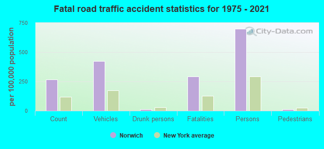
Type |
2009 |
2010 |
2011 |
2012 |
2013 |
2014 |
2015 |
2016 |
2017 |
2018 |
2019 |
2020 |
2021 |
2022 |
|---|---|---|---|---|---|---|---|---|---|---|---|---|---|---|
| Murders (per 100,000) | 0 (0.0) | 0 (0.0) | 0 (0.0) | 0 (0.0) | 0 (0.0) | 0 (0.0) | 0 (0.0) | 0 (0.0) | 0 (0.0) | 1 (15.0) | 0 (0.0) | 0 (0.0) | 0 (0.0) | 0 (0.0) |
| Rapes (per 100,000) | 5 (71.9) | 4 (55.6) | 5 (69.2) | 10 (139.3) | 4 (56.7) | 7 (100.2) | 14 (200.9) | 13 (187.6) | 14 (205.8) | 16 (240.4) | 15 (227.9) | 12 (185.4) | 1 (15.7) | 13 (193.6) |
| Robberies (per 100,000) | 4 (57.5) | 2 (27.8) | 3 (41.5) | 7 (97.5) | 0 (0.0) | 4 (57.3) | 0 (0.0) | 6 (86.6) | 0 (0.0) | 1 (15.0) | 0 (0.0) | 5 (77.2) | 0 (0.0) | 3 (44.7) |
| Assaults (per 100,000) | 3 (43.1) | 3 (41.7) | 13 (180.0) | 1 (13.9) | 11 (156.1) | 12 (171.8) | 7 (100.4) | 5 (72.2) | 12 (176.4) | 13 (195.3) | 13 (197.5) | 11 (169.9) | 0 (0.0) | 11 (163.8) |
| Burglaries (per 100,000) | 50 (719.0) | 35 (486.8) | 55 (761.6) | 48 (668.7) | 25 (354.7) | 40 (572.7) | 23 (330.0) | 30 (433.0) | 22 (323.3) | 14 (210.3) | 31 (471.1) | 24 (370.7) | 4 (62.8) | 19 (282.9) |
| Thefts (per 100,000) | 252 (3,624) | 243 (3,380) | 275 (3,808) | 260 (3,622) | 297 (4,213) | 235 (3,364) | 214 (3,070) | 220 (3,175) | 167 (2,454) | 154 (2,314) | 153 (2,325) | 142 (2,193) | 38 (596.5) | 192 (2,859) |
| Auto thefts (per 100,000) | 6 (86.3) | 7 (97.4) | 2 (27.7) | 6 (83.6) | 3 (42.6) | 1 (14.3) | 3 (43.0) | 1 (14.4) | 0 (0.0) | 2 (30.0) | 2 (30.4) | 3 (46.3) | 1 (15.7) | 3 (44.7) |
| Arson (per 100,000) | 0 (0.0) | 0 (0.0) | 1 (13.8) | 0 (0.0) | 0 (0.0) | 0 (0.0) | 0 (0.0) | 0 (0.0) | 1 (14.7) | 0 (0.0) | 0 (0.0) | 0 (0.0) | 1 (15.7) | 4 (59.6) |
| City-Data.com crime index | 285.6 | 238.2 | 311.7 | 341.9 | 273.4 | 307.5 | 330.1 | 349.0 | 320.7 | 375.6 | 350.3 | 322.8 | 42.1 | 338.7 |
The City-Data.com crime index weighs serious crimes and violent crimes more heavily. Higher means more crime, U.S. average is 246.1. It adjusts for the number of visitors and daily workers commuting into cities.
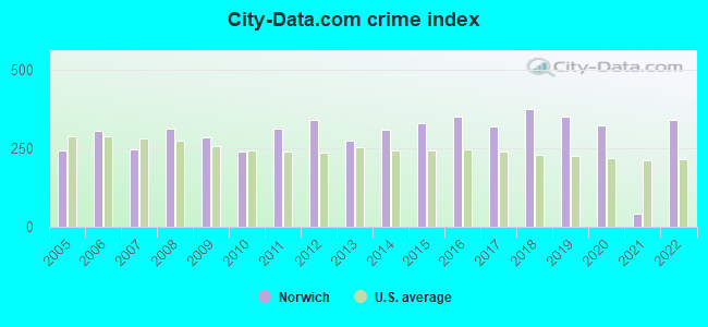
Crime rate in Norwich detailed stats: murders, rapes, robberies, assaults, burglaries, thefts, arson
Full-time law enforcement employees in 2021, including police officers: 21 (20 officers - 19 male; 1 female).
| Officers per 1,000 residents here: | 3.14 |
| New York average: | 3.28 |
 Recent articles from our blog. Our writers, many of them Ph.D. graduates or candidates, create easy-to-read articles on a wide variety of topics.

 | Retiring in Norwich NY (2 replies) |
| Up to $850K in Nassau.... (263 replies) |
| Demographic shifts in many Long island school districts (123 replies) |
| Girls flag football officially comes to New York State (262 replies) |
| Best Villages/Small Towns for a Summer Home? (19 replies) |
| smaller Upstate NY cities and towns/African American communities (5956 replies) |
Latest news from Norwich, NY collected exclusively by city-data.com from local newspapers, TV, and radio stations
Ancestries: English (16.0%), American (11.9%), German (11.7%), Italian (11.7%), Irish (8.5%), Polish (3.0%).
Current Local Time: EST time zone
Incorporated in 1816
Elevation: 1015 feet
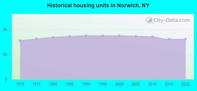
Land area: 2.04 square miles.
Population density: 3,343 people per square mile (average).
356 residents are foreign born (3.5% Latin America, 0.9% Europe, 0.6% North America).
| This city: | 5.2% |
| New York: | 22.6% |
Median real estate property taxes paid for housing units with mortgages in 2022: $3,709 (2.9%)
Median real estate property taxes paid for housing units with no mortgage in 2022: $2,601 (2.4%)
Nearest city with pop. 50,000+: Union, NY (38.6 miles  , pop. 56,298).
Nearest city with pop. 200,000+: Rochester, NY (114.7 miles , pop. 219,773).
Nearest city with pop. 1,000,000+: Bronx, NY (144.3 miles , pop. 1,332,650).
Nearest cities:
), ), ), ), ), Latitude: 42.53 N, Longitude: 75.52 W
Daytime population change due to commuting: +2,093 (+30.6%)
Workers who live and work in this city: 1,398 (47.7%)
Area code: 607
Norwich tourist attractions:
Norwich, New York accommodation & food services, waste management - Economy and Business Data
Single-family new house construction building permits:
- 2014: 3 buildings, average cost: $43,600
- 2013: 3 buildings, average cost: $43,600
- 2010: 1 building, cost: $137,500
- 2009: 1 building, cost: $137,500
- 2008: 2 buildings, average cost: $137,500
- 2007: 1 building, cost: $175,000
- 2006: 1 building, cost: $175,000
- 2005: 1 building, cost: $175,000
- 2004: 1 building, cost: $175,000
- 2003: 1 building, cost: $98,300
- 2002: 1 building, cost: $160,000
- 2001: 2 buildings, average cost: $62,500
- 2000: 1 building, cost: $55,000
| Here: | 4.2% |
| New York: | 4.4% |
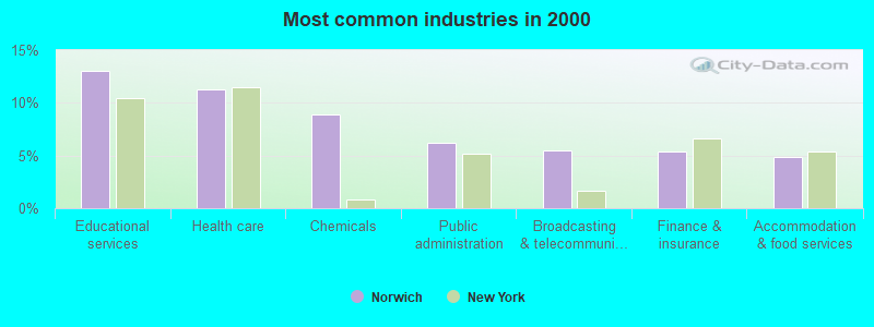
- Educational services (13.1%)
- Health care (11.2%)
- Chemicals (8.9%)
- Public administration (6.2%)
- Broadcasting & telecommunications (5.5%)
- Finance & insurance (5.4%)
- Accommodation & food services (4.8%)
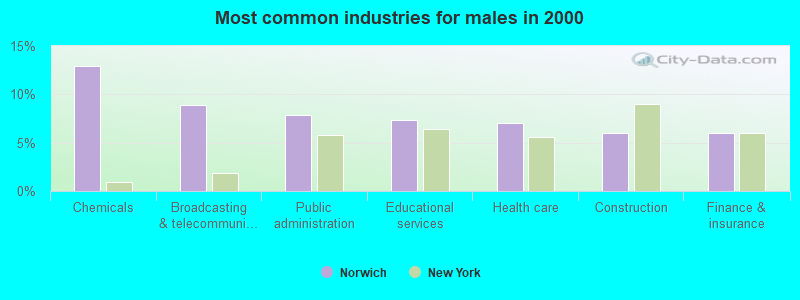
- Chemicals (13.0%)
- Broadcasting & telecommunications (8.9%)
- Public administration (7.9%)
- Educational services (7.4%)
- Health care (7.0%)
- Construction (6.0%)
- Finance & insurance (6.0%)
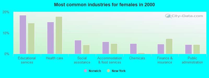
- Educational services (18.5%)
- Health care (15.3%)
- Social assistance (6.6%)
- Accommodation & food services (5.9%)
- Chemicals (5.0%)
- Finance & insurance (4.8%)
- Public administration (4.5%)
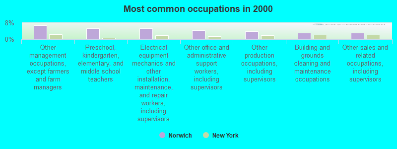
- Other management occupations, except farmers and farm managers (6.8%)
- Preschool, kindergarten, elementary, and middle school teachers (5.4%)
- Electrical equipment mechanics and other installation, maintenance, and repair workers, including supervisors (5.3%)
- Other office and administrative support workers, including supervisors (4.5%)
- Other production occupations, including supervisors (3.8%)
- Building and grounds cleaning and maintenance occupations (3.1%)
- Other sales and related occupations, including supervisors (3.0%)
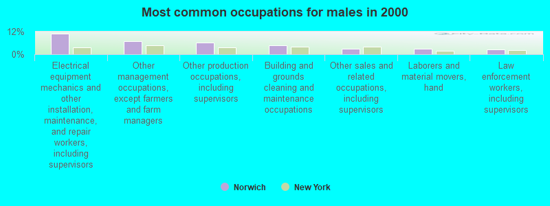
- Electrical equipment mechanics and other installation, maintenance, and repair workers, including supervisors (11.0%)
- Other management occupations, except farmers and farm managers (6.9%)
- Other production occupations, including supervisors (6.1%)
- Building and grounds cleaning and maintenance occupations (4.9%)
- Other sales and related occupations, including supervisors (2.9%)
- Laborers and material movers, hand (2.8%)
- Law enforcement workers, including supervisors (2.7%)
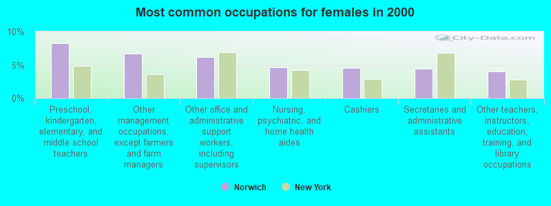
- Preschool, kindergarten, elementary, and middle school teachers (8.3%)
- Other management occupations, except farmers and farm managers (6.7%)
- Other office and administrative support workers, including supervisors (6.2%)
- Nursing, psychiatric, and home health aides (4.6%)
- Cashiers (4.6%)
- Secretaries and administrative assistants (4.4%)
- Other teachers, instructors, education, training, and library occupations (4.0%)
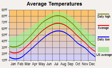
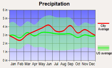
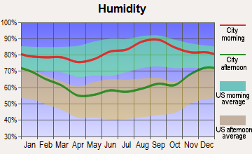
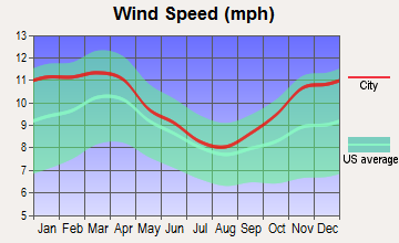
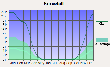
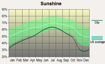
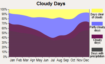
Average climate in Norwich, New York
Based on data reported by over 4,000 weather stations
|
|

(lower is better)
Air Quality Index (AQI) level in 2011 was 52.6. This is better than average.
| City: | 52.6 |
| U.S.: | 72.6 |
Sulfur Dioxide (SO2) [ppb] level in 2011 was 0.547. This is significantly better than average. Closest monitor was 19.2 miles away from the city center.
| City: | 0.547 |
| U.S.: | 1.515 |
Ozone [ppb] level in 2011 was 30.6. This is about average. Closest monitor was 19.2 miles away from the city center.
| City: | 30.6 |
| U.S.: | 33.3 |
Tornado activity:
Norwich-area historical tornado activity is slightly below New York state average. It is 67% smaller than the overall U.S. average.
On 5/31/1998, a category F3 (max. wind speeds 158-206 mph) tornado 21.5 miles away from the Norwich city center injured 3 people and caused $800,000 in damages.
On 5/31/1998, a category F2 (max. wind speeds 113-157 mph) tornado 7.3 miles away from the city center caused $500,000 in damages.
Earthquake activity:
Norwich-area historical earthquake activity is significantly above New York state average. It is 67% smaller than the overall U.S. average.On 10/7/1983 at 10:18:46, a magnitude 5.3 (5.1 MB, 5.3 LG, 5.1 ML, Class: Moderate, Intensity: VI - VII) earthquake occurred 114.9 miles away from the city center
On 4/20/2002 at 10:50:47, a magnitude 5.3 (5.3 ML, Depth: 3.0 mi) earthquake occurred 164.7 miles away from Norwich center
On 4/20/2002 at 10:50:47, a magnitude 5.2 (5.2 MB, 4.2 MS, 5.2 MW, 5.0 MW) earthquake occurred 162.7 miles away from the city center
On 8/23/2011 at 17:51:04, a magnitude 5.8 (5.8 MW, Depth: 3.7 mi) earthquake occurred 344.2 miles away from Norwich center
On 9/25/1998 at 19:52:52, a magnitude 5.2 (4.8 MB, 4.3 MS, 5.2 LG, 4.5 MW, Depth: 3.1 mi) earthquake occurred 260.6 miles away from the city center
On 6/17/1991 at 08:53:16, a magnitude 4.1 (4.0 MB, 4.0 LG, Depth: 3.1 mi, Class: Light, Intensity: IV - V) earthquake occurred 43.5 miles away from the city center
Magnitude types: regional Lg-wave magnitude (LG), body-wave magnitude (MB), local magnitude (ML), surface-wave magnitude (MS), moment magnitude (MW)
Natural disasters:
The number of natural disasters in Chenango County (25) is a lot greater than the US average (15).Major Disasters (Presidential) Declared: 14
Emergencies Declared: 8
Causes of natural disasters: Storms: 11, Floods: 9, Snowstorms: 3, Tropical Storms: 3, Hurricanes: 2, Tornadoes: 2, Winds: 2, Blizzard: 1, Ice Storm: 1, Power Outage: 1, Tropical Depression: 1, Winter Storm: 1, Other: 2 (Note: some incidents may be assigned to more than one category).
Main business address for: NBT BANCORP INC (NATIONAL COMMERCIAL BANKS).
Hospitals and medical centers in Norwich:
- CHENANGO MEMORIAL HOSPITAL, INC (Voluntary non-profit - Private, provides emergency services, 179 NORTH BROAD STREET)
- HOSPICE OF CHENANGO COUNTY (21 HAYES ST)
- VALLEY RIDGE CENTER FOR INTENSIVE TREATMENT (276 CHIARINO DRIVE)
- NORWICH REHABILITATION AND NURSING CENTER (88 CALVARY DRIVE)
- VALLEY VIEW MANOR NURSING HOME (40 PARK STREET)
Airports and heliports located in Norwich:
- Lt Warren Eaton Airport (OIC) (Runways: 1, Air Taxi Ops: 3,200, Itinerant Ops: 4,500, Local Ops: 9,500, Military Ops: 100)
- Uhs Chenango Memorial Hospital Heliport (9NK2)
College/University in Norwich:
Colleges/universities with over 2000 students nearest to Norwich:
- Colgate University (about 20 miles; Hamilton, NY; Full-time enrollment: 3,094)
- SUNY Oneonta (about 24 miles; Oneonta, NY; FT enrollment: 6,081)
- Morrisville State College (about 26 miles; Morrisville, NY; FT enrollment: 2,823)
- SUNY Broome Community College (about 34 miles; Binghamton, NY; FT enrollment: 4,969)
- SUNY College at Cortland (about 35 miles; Cortland, NY; FT enrollment: 6,838)
- SUNY College of Technology at Delhi (about 36 miles; Delhi, NY; FT enrollment: 2,911)
- SUNY at Binghamton (about 39 miles; Vestal, NY; FT enrollment: 15,096)
Public high schools in Norwich:
- NORWICH HIGH SCHOOL (Students: 694, Location: 49 MIDLAND DR, Grades: 9-12)
- DELAWARE-CHENANGO-MADISON-OTSEGO BOCES (Location: 6678 COUNTY RD 32, Grades: KG-12)
Private high school in Norwich:
- VALLEY HEIGHTS CHRISTIAN ACADEMY (Students: 87, Location: 75 CALVARY DR, Grades: PK-12)
Public elementary/middle schools in Norwich:
- STANFORD J GIBSON PRIMARY SCHOOL (Students: 536, Location: 8 RIDGELAND RD, Grades: PK-2)
- NORWICH MIDDLE SCHOOL (Students: 483, Location: 89 MIDLAND DR, Grades: 6-8)
- PERRY BROWNE INTERMEDIATE SCHOOL (Students: 462, Location: 31 BEEBE AVE, Grades: 3-5)
Private elementary/middle school in Norwich:
User-submitted facts and corrections:
- Nearest city with population 200,000 plus would be Syracuse,N.Y.
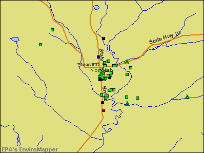
Points of interest:
Notable locations in Norwich: Chenango County Historical Society (A), Chenango Valley Home For Aged Women (B), Chenango County Office Building (C), Guernsey Homestead Memorial Library (D), Colonia Theatre (E), Norwich Fire Department (F), Norwich City Hall (G), Norwich Club (H), Chenango County Court House (I), Chenango Memorial Hospital Residential Health Care Facility (J), Grace View Manor Assisted Living Facility (K), Pearl and Everett Gilmour Health Care Facility (L), United Methodist Homes Doris L Patrick Campus (M), Valley View Manor Nursing Home (N). Display/hide their locations on the map
Main business address in Norwich: NBT BANCORP INC (A). Display/hide its location on the map
Churches in Norwich include: Assembly of God Church (A), Calvary Baptist Church (B), Christ Lutheran Church (C), Christian Missionary Alliance (D), The Church of Jesus Christ of Latter Day Saints (E), New Beginnings Church (F), Saint Paul's Roman Catholic Church (G), Emmanuel Episcopal Church (H), Norwich Jewish Center (I). Display/hide their locations on the map
Creek: Canasawacta Creek (A). Display/hide its location on the map
Parks in Norwich include: West Park (1), East Park (2), Peacock Park (3). Display/hide their locations on the map
Tourist attractions: Car Museum Northeast Classic (24 Rexford Street), Bullthistle Model Railroad Society Inc (Museums; 33 Rexford Street).
Hotel: A Wee Bit of Bonnie Scotland Bed & Breakfast (7052 State Highway 12).
Courts: Chenango County - Supreme Court- Supreme Court Clerk (5 South Broad Street), Chenango County Realty (5449 Route 12), Chenango County Government - Supreme Court Chambersingraham- Courts- Supreme Court Chambers (Courthouse), Chenango County Government - Family Court (5 Court Street), Chenango County Government - Courts- Surrogate Court Clerk (5 Court Street), Norwich City - City Court (1 Court Plaza), Chenango County Government - Courts- County Court Chambers Sullivan (5 Court Street).
Birthplace of: Meade Purdy - Politician.
Drinking water stations with addresses in Norwich and their reported violations in the past:
GAUIS COOK MEMORIAL PARK (Address: 5 COURT STREET , Population served: 175, Groundwater):Past monitoring violations:NORWICH YMCA-CAMP THOMPSON (Address: 68 NORTH BROAD ST. , Population served: 65, Groundwater):
- 2 routine major monitoring violations
- One regular monitoring violation
Past monitoring violations:HEADSTART-N. NORWICH TOWN HALL (Population served: 40, Groundwater):
- 2 routine major monitoring violations
Past monitoring violations:HEADSTART-EARLY (Address: 44 WEST MAIN ST. , Population served: 30, Groundwater):
- 2 routine major monitoring violations
Past monitoring violations:LINDYS ICE CREAM SHOP (Population served: 25, Groundwater):
- One routine major monitoring violation
Past monitoring violations:FREDS INN MOTEL (UV) (Address: 5149 STATE HWY 12 , Population served: 25, Groundwater):
- One routine major monitoring violation
Past monitoring violations:
- 2 routine major monitoring violations
| This city: | 2.2 people |
| New York: | 2.6 people |
| This city: | 54.1% |
| Whole state: | 63.5% |
| This city: | 11.8% |
| Whole state: | 6.8% |
Likely homosexual households (counted as self-reported same-sex unmarried-partner households)
- Lesbian couples: 0.4% of all households
- Gay men: 0.4% of all households
People in group quarters in Norwich in 2010:
- 219 people in nursing facilities/skilled-nursing facilities
- 16 people in residential treatment centers for adults
- 4 people in group homes intended for adults
- 3 people in other noninstitutional facilities
People in group quarters in Norwich in 2000:
- 339 people in nursing homes
- 73 people in other noninstitutional group quarters
- 53 people in local jails and other confinement facilities (including police lockups)
- 24 people in homes for the mentally retarded
- 15 people in homes for the mentally ill
Banks with branches in Norwich (2011 data):
- NBT Bank, National Association: South Plaza Branch, Nbt Bank, National Association, North Plaza Branch. Info updated 2012/02/02: Bank assets: $5,558.5 mil, Deposits: $4,381.4 mil, local headquarters, positive income, Commercial Lending Specialization, 133 total offices, Holding Company: Nbt Bancorp Inc.
- Community Bank, National Association: Norwich City Branch at 18 South Broad Street, branch established on 1888/01/01; Norwich Branch at 4837 State Highway 23, branch established on 2001/10/18. Info updated 2011/06/13: Bank assets: $6,460.6 mil, Deposits: $4,840.4 mil, headquarters in Canton, NY, positive income, 175 total offices, Holding Company: Community Bank System, Inc.
- Manufacturers and Traders Trust Company: Norwich North Plaza Branch at 118 State Highway 320, branch established on 1975/12/15. Info updated 2011/08/08: Bank assets: $76,887.1 mil, Deposits: $60,064.2 mil, headquarters in Buffalo, NY, positive income, Commercial Lending Specialization, 808 total offices, Holding Company: M&T Bank Corporation
For population 15 years and over in Norwich:
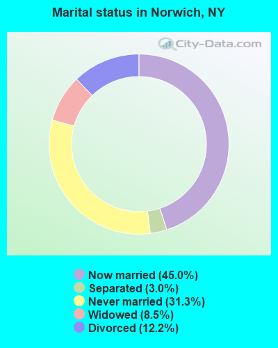
- Never married: 31.3%
- Now married: 45.0%
- Separated: 3.0%
- Widowed: 8.5%
- Divorced: 12.2%
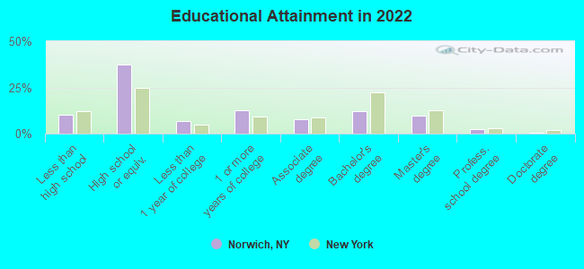
For population 25 years and over in Norwich:
- High school or higher: 89.2%
- Bachelor's degree or higher: 24.1%
- Graduate or professional degree: 12.5%
- Unemployed: 6.4%
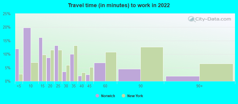
- Mean travel time to work (commute): 16.5 minutes
| Here: | 11.0 |
| New York average: | 13.9 |
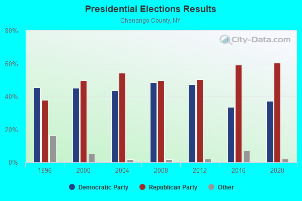
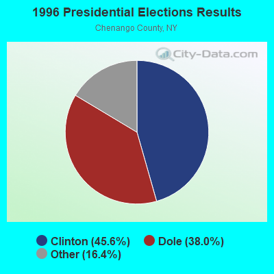
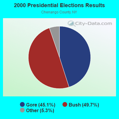
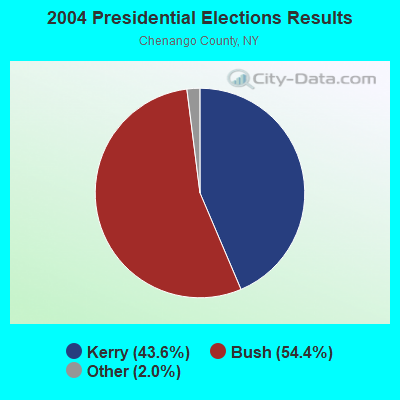
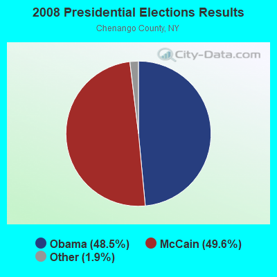
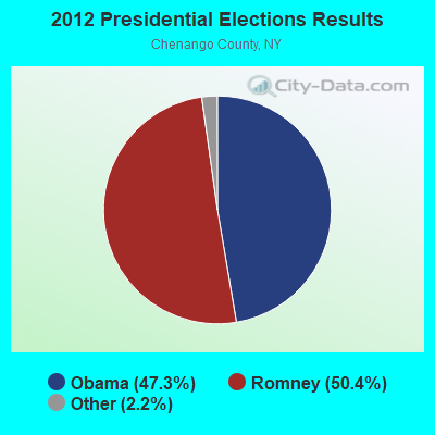
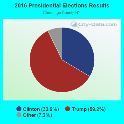
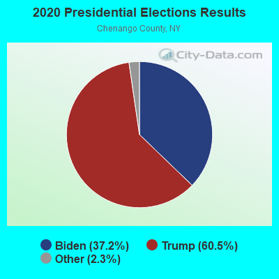
Graphs represent county-level data. Detailed 2008 Election Results
Religion statistics for Norwich, NY (based on Chenango County data)
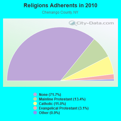
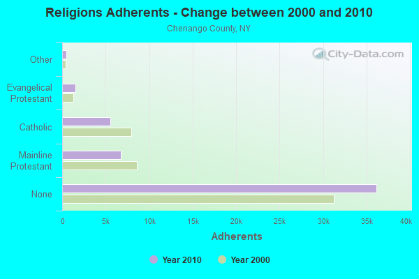
| Religion | Adherents | Congregations |
|---|---|---|
| Mainline Protestant | 6,744 | 39 |
| Catholic | 5,528 | 8 |
| Evangelical Protestant | 1,563 | 25 |
| Other | 471 | 5 |
| None | 36,171 | - |
Food Environment Statistics:
| This county: | 2.54 / 10,000 pop. |
| State: | 4.13 / 10,000 pop. |
| This county: | 0.39 / 10,000 pop. |
| New York: | 0.92 / 10,000 pop. |
| Chenango County: | 5.87 / 10,000 pop. |
| New York: | 1.68 / 10,000 pop. |
| Chenango County: | 7.24 / 10,000 pop. |
| State: | 8.82 / 10,000 pop. |
| Chenango County: | 8.8% |
| New York: | 8.2% |
| Chenango County: | 27.4% |
| New York: | 23.8% |
| Chenango County: | 13.6% |
| New York: | 15.6% |
Health and Nutrition:
| This city: | 50.8% |
| State: | 50.1% |
| Norwich: | 46.9% |
| State: | 48.1% |
| Norwich: | 28.7 |
| New York: | 28.5 |
| Norwich: | 19.6% |
| State: | 20.3% |
| This city: | 12.9% |
| New York: | 11.1% |
| This city: | 6.8 |
| State: | 6.8 |
| Here: | 35.1% |
| State: | 33.4% |
| Norwich: | 55.5% |
| State: | 56.5% |
| Norwich: | 76.7% |
| New York: | 80.2% |
More about Health and Nutrition of Norwich, NY Residents
| Local government employment and payroll (March 2022) | |||||
| Function | Full-time employees | Monthly full-time payroll | Average yearly full-time wage | Part-time employees | Monthly part-time payroll |
|---|---|---|---|---|---|
| Police Protection - Officers | 18 | $113,669 | $75,779 | 0 | $0 |
| Firefighters | 16 | $93,588 | $70,191 | 0 | $0 |
| Streets and Highways | 12 | $58,782 | $58,782 | 0 | $0 |
| Financial Administration | 8 | $33,256 | $49,884 | 0 | $0 |
| Other Government Administration | 4 | $36,215 | $108,645 | 7 | $3,510 |
| Water Supply | 3 | $13,849 | $55,396 | 0 | $0 |
| Other and Unallocable | 2 | $16,764 | $100,584 | 0 | $0 |
| Police - Other | 2 | $15,628 | $93,768 | 1 | $1,169 |
| Sewerage | 2 | $14,019 | $84,114 | 0 | $0 |
| Fire - Other | 1 | $7,866 | $94,392 | 0 | $0 |
| Parks and Recreation | 1 | $3,489 | $41,868 | 0 | $0 |
| Welfare | 0 | $0 | 10 | $4,493 | |
| Judicial and Legal | 0 | $0 | 1 | $3,182 | |
| Totals for Government | 69 | $407,128 | $70,805 | 19 | $12,354 |
Norwich government finances - Expenditure in 2017 (per resident):
- Construction - Water Utilities: $2,680,000 ($393.42)
Regular Highways: $229,000 ($33.62)
- Current Operations - General - Other: $2,820,000 ($413.98)
Local Fire Protection: $1,491,000 ($218.88)
Police Protection: $1,376,000 ($202.00)
Regular Highways: $763,000 ($112.01)
Sewerage: $748,000 ($109.81)
Water Utilities: $653,000 ($95.86)
Central Staff Services: $316,000 ($46.39)
Financial Administration: $230,000 ($33.76)
General Public Buildings: $156,000 ($22.90)
Parks and Recreation: $151,000 ($22.17)
Protective Inspection and Regulation - Other: $88,000 ($12.92)
Housing and Community Development: $73,000 ($10.72)
Judicial and Legal Services: $48,000 ($7.05)
Solid Waste Management: $30,000 ($4.40)
Health - Other: $1,000 ($0.15)
Natural Resources - Other: $1,000 ($0.15)
- General - Interest on Debt: $296,000 ($43.45)
- Intergovernmental to Local - Other - Financial Administration: $41,000 ($6.02)
- Other Capital Outlay - Sewerage: $192,000 ($28.19)
Parks and Recreation: $36,000 ($5.28)
Water Utilities: $20,000 ($2.94)
General - Other: $11,000 ($1.61)
Local Fire Protection: $7,000 ($1.03)
Protective Inspection and Regulation - Other: $2,000 ($0.29)
Central Staff Services: $1,000 ($0.15)
- Total Salaries and Wages: $4,201,000 ($616.71)
Norwich government finances - Revenue in 2017 (per resident):
- Charges - Sewerage: $1,125,000 ($165.15)
Other: $843,000 ($123.75)
Parks and Recreation: $11,000 ($1.61)
- Federal Intergovernmental - Other: $317,000 ($46.54)
- Local Intergovernmental - Other: $786,000 ($115.38)
- Miscellaneous - General Revenue - Other: $209,000 ($30.68)
Fines and Forfeits: $24,000 ($3.52)
Donations From Private Sources: $23,000 ($3.38)
Interest Earnings: $6,000 ($0.88)
Sale of Property: $1,000 ($0.15)
Rents: $1,000 ($0.15)
- Revenue - Water Utilities: $1,610,000 ($236.35)
- State Intergovernmental - General Local Government Support: $1,089,000 ($159.86)
Highways: $253,000 ($37.14)
Other: $240,000 ($35.23)
- Tax - Property: $3,520,000 ($516.74)
General Sales and Gross Receipts: $1,528,000 ($224.31)
Public Utilities Sales: $152,000 ($22.31)
Other License: $112,000 ($16.44)
Norwich government finances - Debt in 2017 (per resident):
- Long Term Debt - Beginning Outstanding - Unspecified Public Purpose: $5,623,000 ($825.46)
Outstanding Unspecified Public Purpose: $4,933,000 ($724.16)
Retired Unspecified Public Purpose: $691,000 ($101.44)
- Short Term Debt Outstanding - End of Fiscal Year: $7,283,000 ($1069.14)
Beginning: $5,135,000 ($753.82)
Norwich government finances - Cash and Securities in 2017 (per resident):
- Bond Funds - Cash and Securities: $4,837,000 ($710.07)
- Other Funds - Cash and Securities: $6,802,000 ($998.53)
- Sinking Funds - Cash and Securities: $272,000 ($39.93)
| Businesses in Norwich, NY | ||||
| Name | Count | Name | Count | |
|---|---|---|---|---|
| AT&T | 2 | McDonald's | 1 | |
| Advance Auto Parts | 1 | New Balance | 1 | |
| Arby's | 1 | Nike | 2 | |
| Burger King | 1 | Pizza Hut | 1 | |
| Chevrolet | 1 | RadioShack | 1 | |
| Dennys | 1 | Rite Aid | 1 | |
| Dunkin Donuts | 2 | Subaru | 1 | |
| Fashion Bug | 1 | Subway | 2 | |
| FedEx | 2 | Super 8 | 1 | |
| Ford | 1 | Taco Bell | 1 | |
| GNC | 1 | Tim Hortons | 1 | |
| H&R Block | 1 | U-Haul | 3 | |
| Howard Johnson | 1 | UPS | 2 | |
| KFC | 1 | Walmart | 1 | |
| Lane Furniture | 1 | YMCA | 1 | |
| Lowe's | 1 | |||
Strongest AM radio stations in Norwich:
- WCHN (970 AM; 1 kW; NORWICH, NY; Owner: BANJO COMMUNICATIONS GROUP, INC)
- WGY (810 AM; 50 kW; SCHENECTADY, NY; Owner: CLEAR CHANNEL BROADCASTING LICENSES, INC.)
- WINR (680 AM; 5 kW; BINGHAMTON, NY; Owner: CLEVELAND RADIO LICENSES, LLC)
- WNBF (1290 AM; 9 kW; BINGHAMTON, NY; Owner: CITADEL BROADCASTING COMPANY)
- WPTR (1540 AM; 50 kW; ALBANY, NY; Owner: KIMTRON, INC.)
- WSYR (570 AM; 5 kW; SYRACUSE, NY; Owner: CLEAR CHANNEL BROADCASTING LICENSES, INC.)
- WMCA (570 AM; 50 kW; NEW YORK, NY; Owner: SALEM MEDIA OF NEW YORK, LLC)
- WNNZ (640 AM; 50 kW; WESTFIELD, MA; Owner: CLEAR CHANNEL BROADCASTING LICENSES, INC.)
- WOR (710 AM; 50 kW; NEW YORK, NY; Owner: BUCKLEY BROADCASTING CORPORATION)
- WABC (770 AM; 50 kW; NEW YORK, NY; Owner: WABC-AM RADIO, INC.)
- WFAN (660 AM; 50 kW; NEW YORK, NY; Owner: INFINITY BROADCASTING OPERATIONS, INC.)
- WWJZ (640 AM; 50 kW; MOUNT HOLLY, NJ; Owner: ABC, INC.)
- WDLA (1270 AM; 5 kW; WALTON, NY; Owner: BANJO COMMUNICATIONS GROUP, INC.)
Strongest FM radio stations in Norwich:
- WKXZ (93.9 FM; NORWICH, NY; Owner: BANJO COMMUNICATIONS GROUP, INC)
- WBKT (95.3 FM; NORWICH, NY; Owner: BANJO COMMUNICATIONS GROUP, INC)
- WCDO-FM (100.9 FM; SIDNEY, NY; Owner: CDO BROADCASTING, INC.)
- W232AT (94.3 FM; NORWICH, NY; Owner: BANJO COMMUNICATIONS GROUP, INC)
- WHWK (98.1 FM; BINGHAMTON, NY; Owner: CITADEL BROADCASTING COMPANY)
- WAAL (99.1 FM; BINGHAMTON, NY; Owner: CITADEL BROADCASTING COMPANY)
- WSKG-FM (89.3 FM; BINGHAMTON, NY; Owner: WSKG PUB.TELECOMMUNICATIONS COUNCIL)
- WGKR (105.3 FM; GRAND GORGE, NY; Owner: SOUND OF LIFE, INC.)
- WMXW (103.3 FM; VESTAL, NY; Owner: CLEAR CHANNEL BROADCASTING LICENSES, INC.)
- WSQX-FM (91.5 FM; BINGHAMTON, NY; Owner: WSKG PUBLIC TELECOMMUNICATIONS CNCL.)
- W210BL (89.9 FM; NORWICH, NY; Owner: FAMILY LIFE MINISTRIES, INC.)
- WWDG (105.1 FM; DERUYTER, NY; Owner: CLEAR CHANNEL BROADCASTING LICENSES, INC.)
- WIII (99.9 FM; CORTLAND, NY; Owner: CITADEL BROADCASTING COMPANY)
- WSQC-FM (91.7 FM; ONEONTA, NY; Owner: WSKG PUBLIC TELECOMM. COUNCIL)
- WSRK (103.9 FM; ONEONTA, NY; Owner: ULTIMATE B/CASTING NETWORK, INC.)
- WKGB-FM (92.5 FM; CONKLIN, NY; Owner: CLEAR CHANNEL BROADCASTING LICENSES, INC.)
- WWYL (104.1 FM; CHENANGO BRIDGE, NY; Owner: CITADEL BROADCASTING COMPANY)
- WIFF (90.1 FM; BINGHAMTON, NY; Owner: CSN INTERNATIONAL)
- WMCR-FM (106.3 FM; ONEIDA, NY; Owner: WARREN BROADCASTING CO. INC.)
- WSKS (97.9 FM; WHITESBORO, NY; Owner: CLEAR CHANNEL BROADCASTING LICENSES, INC.)
TV broadcast stations around Norwich:
- WIXT-TV (Channel 9; SYRACUSE, NY; Owner: CENTRAL NY NEWS, INC.)
- WFXV (Channel 33; UTICA, NY; Owner: QUORUM OF UTICA LICENSE, LLC)
- WCNY-TV (Channel 24; SYRACUSE, NY; Owner: PUBLIC BROADCASTING COUNCIL OF CENTRAL NEW YORK)
- WSTM-TV (Channel 3; SYRACUSE, NY; Owner: WSTM LICENSE SUBSIDIARY, INC.)
- WSKG-TV (Channel 46; BINGHAMTON, NY; Owner: WSKG PUBLIC TELECOMMUNICATIONS COUNCIL)
- WSYT (Channel 68; SYRACUSE, NY; Owner: WSYT LICENSEE L.P.)
- WICZ-TV (Channel 40; BINGHAMTON, NY; Owner: STAINLESS BROADCASTING, L.P.)
- WNYS-TV (Channel 43; SYRACUSE, NY; Owner: RKM MEDIA, INC.)
Medal of Honor Recipients
Medal of Honor Recipient born in Norwich: Charles Conway Hartigan.
- National Bridge Inventory (NBI) Statistics
- 18Number of bridges
- 148ft / 44.7mTotal length
- $25,210,000Total costs
- 67,792Total average daily traffic
- 4,451Total average daily truck traffic
- 76,902Total future (year 2036) average daily traffic
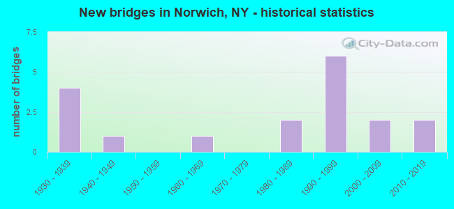
- New bridges - historical statistics
- 41930-1939
- 11940-1949
- 11960-1969
- 21980-1989
- 61990-1999
- 22000-2009
- 22010-2019
FCC Registered Antenna Towers: 34 (See the full list of FCC Registered Antenna Towers)
FCC Registered Broadcast Land Mobile Towers: 26 (See the full list of FCC Registered Broadcast Land Mobile Towers in Norwich, NY)
FCC Registered Microwave Towers: 12 (See the full list of FCC Registered Microwave Towers in this town)
FCC Registered Paging Towers: 1 (See the full list of FCC Registered Paging Towers)
FCC Registered Maritime Coast & Aviation Ground Towers: 3 (See the full list of FCC Registered Maritime Coast & Aviation Ground Towers)
FCC Registered Amateur Radio Licenses: 92 (See the full list of FCC Registered Amateur Radio Licenses in Norwich)
FAA Registered Aircraft: 20 (See the full list of FAA Registered Aircraft in Norwich)
2002 - 2018 National Fire Incident Reporting System (NFIRS) incidents
- Fire incident types reported to NFIRS in Norwich, NY
- 48156.6%Structure Fires
- 15818.6%Outside Fires
- 11613.6%Mobile Property/Vehicle Fires
- 9511.2%Other
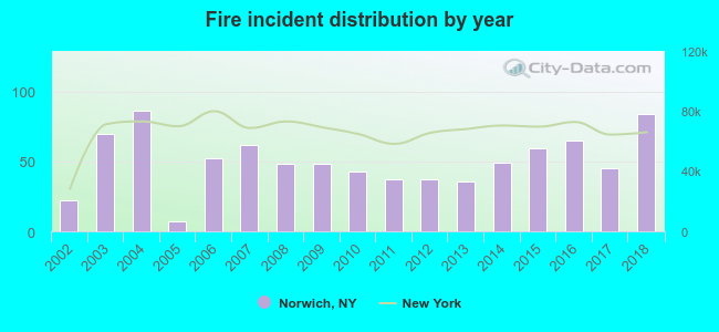 Based on the data from the years 2002 - 2018 the average number of fires per year is 50. The highest number of fire incidents - 86 took place in 2004, and the least - 7 in 2005. The data has a growing trend.
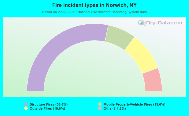 When looking into fire subcategories, the most reports belonged to: Structure Fires (56.6%), and Outside Fires (18.6%).
Fire-safe hotels and motels in Norwich, New York:
- Norwich Super 8, 6067 St Hwy 12, Norwich, New York 13815 , Phone: (607) 336-8880, Fax: (607) 336-2076
- Howard Johnson, 75 N Broad St, Norwich, New York 13815 , Phone: (607) 334-2200, Fax: (607) 336-5619
- Fred's Inn, Inc., 5140 State Hwy 12, Norwich, New York 13815 , Phone: (607) 334-9282, Fax: (607) 336-6767
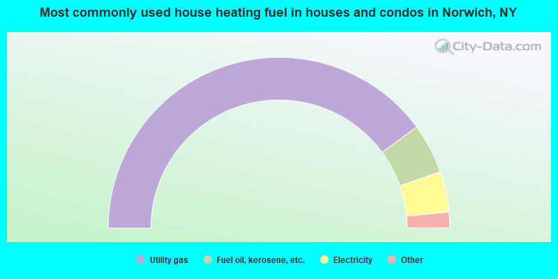
- 80.0%Utility gas
- 9.5%Fuel oil, kerosene, etc.
- 7.7%Electricity
- 1.4%No fuel used
- 1.0%Wood
- 0.4%Bottled, tank, or LP gas
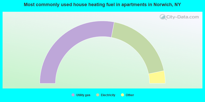
- 56.0%Utility gas
- 37.5%Electricity
- 3.8%Fuel oil, kerosene, etc.
- 1.1%Bottled, tank, or LP gas
- 1.0%No fuel used
- 0.6%Other fuel
Norwich compared to New York state average:
- Median household income below state average.
- Median house value significantly below state average.
- Unemployed percentage below state average.
- Black race population percentage significantly below state average.
- Hispanic race population percentage significantly below state average.
- Foreign-born population percentage significantly below state average.
- Institutionalized population percentage above state average.
Norwich on our top lists:
- #49 on the list of "Top 101 cities with the highest number of rapes per 100,000 residents, excludes tourist destinations and others with a lot of outsiders visiting based on city industries data (population 5,000+)"
- #60 on the list of "Top 101 cities with the largest percentage of unmarried partner households (population 5,000+)"
- #60 on the list of "Top 100 cities with oldest houses (pop. 5,000+)"
- #42 on the list of "Top 101 counties with the lowest surface withdrawal of fresh water for public supply"
- #48 on the list of "Top 101 counties with the lowest total withdrawal of fresh water for public supply (pop. 50,000+)"
- #63 on the list of "Top 101 counties with the largest number of people moving out compared to moving in (pop. 50,000+)"

|
|
Total of 15 patent applications in 2008-2024.