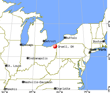
Orwell, Ohio

Orwell: october snow

Orwell: Sunset

Orwell

Orwell: Pond in orwell

Orwell
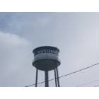
Orwell: water tower
- add
your
Submit your own pictures of this village and show them to the world
- OSM Map
- General Map
- Google Map
- MSN Map
Population change since 2000: +0.3%
 |
| Males: 751 | |
| Females: 773 |
| Median resident age: | 34.0 years |
| Ohio median age: | 39.9 years |
Zip codes: 44076.
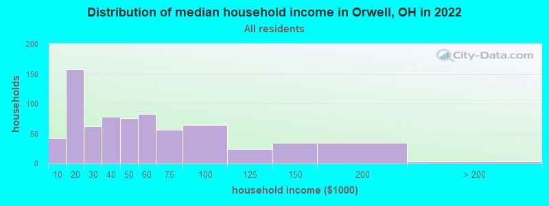
| Orwell: | $40,553 |
| OH: | $65,720 |
Estimated per capita income in 2022: $21,489 (it was $16,160 in 2000)
Orwell village income, earnings, and wages data
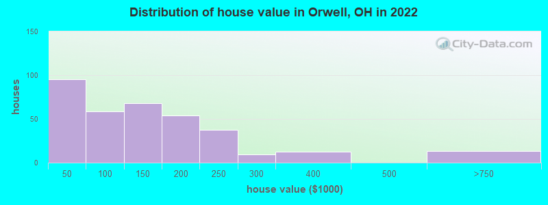
Estimated median house or condo value in 2022: $135,247 (it was $81,300 in 2000)
| Orwell: | $135,247 |
| OH: | $204,100 |
Mean prices in 2022: all housing units: $128,073; detached houses: $160,753; in 2-unit structures: $218,977; mobile homes: $30,623
Median gross rent in 2022: $798.
(25.7% for White Non-Hispanic residents, 100.0% for American Indian residents, 6.8% for two or more races residents)
Detailed information about poverty and poor residents in Orwell, OH

Compare current foreclosures near Orwell, OH:
| Photo | Address | Area | Beds / Baths | Price | Details |
|---|---|---|---|---|---|

|
#1
Leffingwell Dr
Orwell, OH 44076
|
1,024 sq. feet
|
1 baths 3 beds |
show details | |

|
#2
Noe Ave
Orwell, OH 44076
|
- sq. feet
|
1 baths 2 beds |
show details | |

|
#3
W Erie St
Jefferson, OH 44047
|
1,056 sq. feet
|
1 baths 2 beds |
$119,900
|
show details |

|
#4
Greenville Rd
Bristolville, OH 44402
|
2,135 sq. feet
|
1 baths 3 beds |
show details | |

|
#5
Shaffer Rd NW
Warren, OH 44481
|
960 sq. feet
|
1 baths 3 beds |
show details | |

|
#6
W Rd NW
West Farmington, OH 44491
|
1,512 sq. feet
|
2 baths 3 beds |
show details | |

|
#7
Leggett Rd
Montville, OH 44064
|
2,243 sq. feet
|
1 baths 3 beds |
show details | |

|
#8
State Route 46 S
Jefferson, OH 44047
|
1,402 sq. feet
|
2 baths 3 beds |
show details | |

|
#9
Earl Dr NW
Warren, OH 44483
|
1,196 sq. feet
|
1 baths 3 beds |
show details | |

|
#10
Deer Creek Trl
Cortland, OH 44410
|
2,472 sq. feet
|
2 baths 4 beds |
show details |
| Photo | Address | Area | Beds / Baths | Price | Details |
|---|---|---|---|---|---|

|
#11
Maple Ave
Cortland, OH 44410
|
1,939 sq. feet
|
2 baths 3 beds |
show details | |

|
#12
Fallehn Dr
Cortland, OH 44410
|
2,598 sq. feet
|
2 baths 4 beds |
show details | |

|
#13
Fairway Dr
Cortland, OH 44410
|
2,123 sq. feet
|
3 baths 4 beds |
show details | |

|
#14
Fawn Ln
Cortland, OH 44410
|
2,776 sq. feet
|
3 baths 5 beds |
show details | |

|
#15
State Route 7
Williamsfield, OH 44093
|
1,906 sq. feet
|
1 baths 3 beds |
show details | |

|
#16
Durst Dr NW
Warren, OH 44483
|
888 sq. feet
|
1 baths 3 beds |
show details | |

|
#17
W Walnut St
Jefferson, OH 44047
|
1,957 sq. feet
|
1 baths 4 beds |
show details | |

|
#18
Old Oak Dr
Cortland, OH 44410
|
2,431 sq. feet
|
2 baths 4 beds |
show details | |

|
#19
Taylor Wells Rd
Chardon, OH 44024
|
3,377 sq. feet
|
2 baths 3 beds |
show details | |

|
#20
Grove St
Cortland, OH 44410
|
944 sq. feet
|
1 baths 3 beds |
show details |
| Photo | Address | Area | Beds / Baths | Price | Details |
|---|---|---|---|---|---|

|
#21
Mini Ranch Trl
Geneva, OH 44041
|
2,122 sq. feet
|
2 baths 4 beds |
show details | |

|
#22
Fairview Dr
Cortland, OH 44410
|
1,350 sq. feet
|
1 baths 3 beds |
show details | |

|
#23
Doyle Rd
Jefferson, OH 44047
|
1,170 sq. feet
|
1 baths 3 beds |
show details | |

|
#24
Ridge Rd
Cortland, OH 44410
|
1,874 sq. feet
|
1 baths 3 beds |
show details | |

|
#25
Carlton St
Burton, OH 44021
|
1,764 sq. feet
|
2 baths 5 beds |
show details | |

|
#26
Woodrow Ave NW
Warren, OH 44483
|
1,000 sq. feet
|
1 baths 2 beds |
show details | |

|
#27
Ridge Rd
Cortland, OH 44410
|
2,052 sq. feet
|
2 baths 3 beds |
show details | |

|
#28
Oakdale Pl
Cortland, OH 44410
|
2,598 sq. feet
|
2 baths 4 beds |
show details | |

|
#29
Craig Ave NW
Warren, OH 44483
|
1,092 sq. feet
|
1 baths 3 beds |
show details | |

|
#30
Oakdale Pl
Cortland, OH 44410
|
2,598 sq. feet
|
2 baths 4 beds |
show details |
| Photo | Address | Area | Beds / Baths | Price | Details |
|---|---|---|---|---|---|

|
#31
Portal Dr
Cortland, OH 44410
|
1,995 sq. feet
|
2 baths 3 beds |
show details | |

|
#32
S Madison Rd
Madison, OH 44057
|
1,429 sq. feet
|
1 baths 3 beds |
show details | |

|
#33
Stoddard Hayes Rd
Farmdale, OH 44417
|
1,832 sq. feet
|
2 baths 3 beds |
show details | |

|
#34
Cedar Dr
Cortland, OH 44410
|
2,076 sq. feet
|
2 baths 4 beds |
show details | |

|
#35
Rustic Dr
Chardon, OH 44024
|
2,080 sq. feet
|
2 baths 3 beds |
show details | |

|
#36
Corriedale Dr
Cortland, OH 44410
|
1,716 sq. feet
|
1 baths 3 beds |
show details | |

|
#37
Everett Hull Rd
Cortland, OH 44410
|
1,542 sq. feet
|
2 baths 3 beds |
show details | |

|
#38
N Park Ave
Warren, OH 44483
|
1,560 sq. feet
|
2 baths 2 beds |
show details | |

|
#39
Champion Ave W
Warren, OH 44483
|
788 sq. feet
|
1 baths 3 beds |
show details | |

|
#40
State Route 305
Southington, OH 44470
|
1,232 sq. feet
|
1 baths 3 beds |
show details |
| Photo | Address | Area | Beds / Baths | Price | Details |
|---|---|---|---|---|---|

|
#41
Warren Rd
Cortland, OH 44410
|
1,689 sq. feet
|
1 baths 3 beds |
show details | |

|
#42
State Route 193
Andover, OH 44003
|
960 sq. feet
|
1 baths 3 beds |
show details | |

|
#43
Bristol Champion Townline Rd NW
Bristolville, OH 44402
|
2,439 sq. feet
|
2 baths 3 beds |
show details | |

|
#44
Youngstown Kingsville Rd
Farmdale, OH 44417
|
1,296 sq. feet
|
1 baths 3 beds |
show details | |

|
#45
S Elm St
Jefferson, OH 44047
|
1,176 sq. feet
|
2 baths 3 beds |
show details | |

|
#46
Thompson Clark Rd
Bristolville, OH 44402
|
1,992 sq. feet
|
1 baths 3 beds |
show details | |

|
#47
Morgan Rd
Montville, OH 44064
|
1,152 sq. feet
|
2 baths 3 beds |
show details | |

|
#48
Clay St
Montville, OH 44064
|
2,448 sq. feet
|
2 baths 2 beds |
show details | |

|
#49
Barbe Ln
Bristolville, OH 44402
|
2,372 sq. feet
|
1 baths 3 beds |
show details | |

|
Check over 1 million property listings on Foreclosure.com!
|
browse all offers | |||


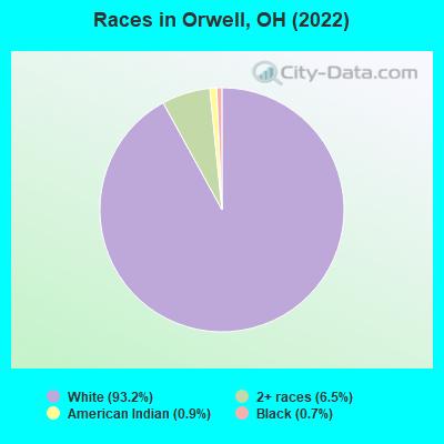
- 1,66993.2%White alone
- 1176.5%Two or more races
- 170.9%American Indian alone
- 120.7%Black alone
Races in Orwell detailed stats: ancestries, foreign born residents, place of birth
According to our research of Ohio and other state lists, there were 12 registered sex offenders living in Orwell, Ohio as of May 14, 2024.
The ratio of all residents to sex offenders in Orwell is 121 to 1.
Type |
2009 |
2010 |
|---|---|---|
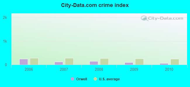
| Murders (per 100,000) | 0 (0.0) | 0 (0.0) |
| Rapes (per 100,000) | 0 (0.0) | 0 (0.0) |
| Robberies (per 100,000) | 0 (0.0) | 0 (0.0) |
| Assaults (per 100,000) | 3 (204.6) | 1 (60.2) |
| Burglaries (per 100,000) | 3 (204.6) | 2 (120.5) |
| Thefts (per 100,000) | 15 (1,023) | 15 (903.6) |
| Auto thefts (per 100,000) | 1 (68.2) | 0 (0.0) |
| Arson (per 100,000) | 0 (0.0) | 0 (0.0) |
| City-Data.com crime index | 101.6 | 56.6 |
The City-Data.com crime index weighs serious crimes and violent crimes more heavily. Higher means more crime, U.S. average is 246.1. It adjusts for the number of visitors and daily workers commuting into cities.
Crime rate in Orwell detailed stats: murders, rapes, robberies, assaults, burglaries, thefts, arson
Full-time law enforcement employees in 2011, including police officers: 5 (5 officers - 4 male; 1 female).
| Officers per 1,000 residents here: | 3.01 |
| Ohio average: | 2.11 |
 Recent articles from our blog. Our writers, many of them Ph.D. graduates or candidates, create easy-to-read articles on a wide variety of topics.


Latest news from Orwell, OH collected exclusively by city-data.com from local newspapers, TV, and radio stations
Ancestries: American (33.0%), English (14.5%), Italian (10.3%), Pennsylvania German (6.7%), European (5.5%), Irish (5.2%).
Current Local Time: EST time zone
Incorporated in 1985
Elevation: 902 feet
Land area: 1.66 square miles.
Population density: 916 people per square mile (low).
2 residents are foreign born
| This village: | 0.1% |
| Ohio: | 4.9% |
| Orwell village: | 1.1% ($880) |
| Ohio: | 1.3% ($1,271) |
Nearest city with pop. 50,000+: Mentor, OH  (27.3 miles , pop. 50,278).
Nearest city with pop. 200,000+: Cleveland, OH (42.1 miles , pop. 478,403).
Nearest city with pop. 1,000,000+: Philadelphia, PA (317.5 miles , pop. 1,517,550).
Nearest cities:
), ), Latitude: 41.53 N, Longitude: 80.86 W
Area code: 440
| Here: | 3.8% |
| Ohio: | 3.1% |
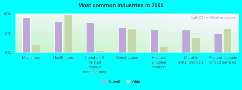
- Machinery (9.1%)
- Health care (8.0%)
- Furniture & related product manufacturing (7.7%)
- Construction (6.3%)
- Plastics & rubber products (5.8%)
- Metal & metal products (5.8%)
- Accommodation & food services (5.0%)
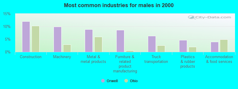
- Construction (12.0%)
- Machinery (9.9%)
- Metal & metal products (8.9%)
- Furniture & related product manufacturing (8.6%)
- Truck transportation (6.2%)
- Plastics & rubber products (4.7%)
- Accommodation & food services (3.9%)
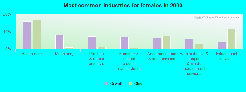
- Health care (15.8%)
- Machinery (8.2%)
- Plastics & rubber products (7.0%)
- Furniture & related product manufacturing (6.7%)
- Accommodation & food services (6.2%)
- Administrative & support & waste management services (5.9%)
- Educational services (4.1%)
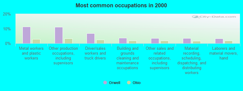
- Metal workers and plastic workers (11.3%)
- Other production occupations, including supervisors (11.0%)
- Driver/sales workers and truck drivers (6.8%)
- Building and grounds cleaning and maintenance occupations (3.7%)
- Other sales and related occupations, including supervisors (3.6%)
- Material recording, scheduling, dispatching, and distributing workers (3.4%)
- Laborers and material movers, hand (3.3%)
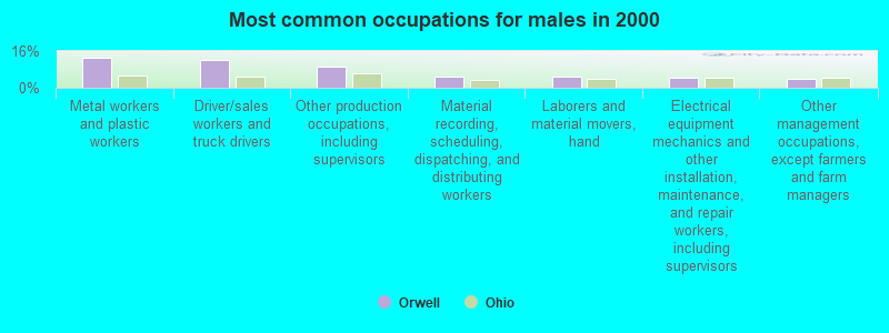
- Metal workers and plastic workers (13.0%)
- Driver/sales workers and truck drivers (12.0%)
- Other production occupations, including supervisors (9.1%)
- Material recording, scheduling, dispatching, and distributing workers (4.9%)
- Laborers and material movers, hand (4.7%)
- Electrical equipment mechanics and other installation, maintenance, and repair workers, including supervisors (4.4%)
- Other management occupations, except farmers and farm managers (3.9%)
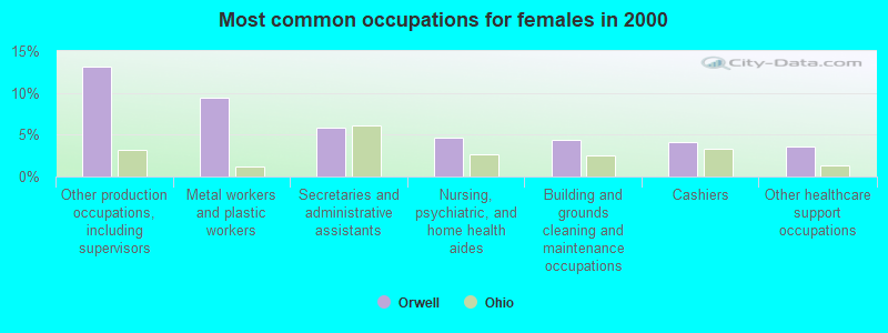
- Other production occupations, including supervisors (13.2%)
- Metal workers and plastic workers (9.4%)
- Secretaries and administrative assistants (5.9%)
- Nursing, psychiatric, and home health aides (4.7%)
- Building and grounds cleaning and maintenance occupations (4.4%)
- Cashiers (4.1%)
- Other healthcare support occupations (3.5%)
Average climate in Orwell, Ohio
Based on data reported by over 4,000 weather stations


|
|

(lower is better)
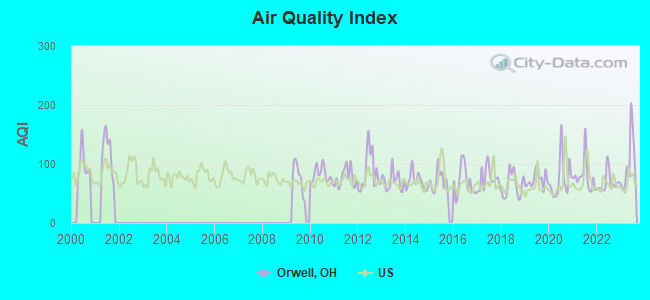
Air Quality Index (AQI) level in 2023 was 101. This is worse than average.
| City: | 101 |
| U.S.: | 73 |

Ozone [ppb] level in 2022 was 31.3. This is about average. Closest monitor was 15.0 miles away from the city center.
| City: | 31.3 |
| U.S.: | 33.3 |
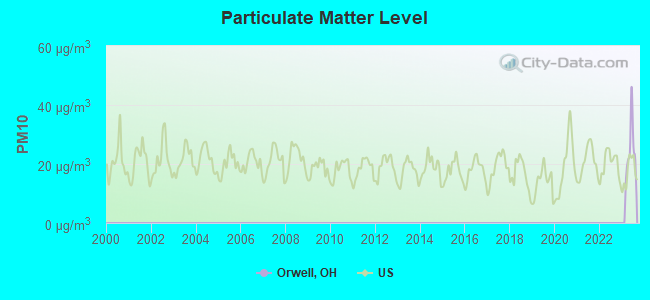
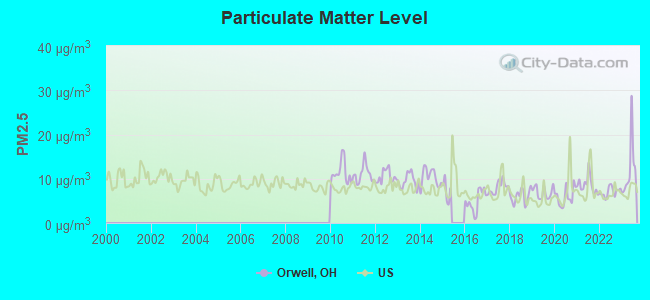
Particulate Matter (PM2.5) [µg/m3] level in 2023 was 12.1. This is significantly worse than average. Closest monitor was 21.0 miles away from the city center.
| City: | 12.1 |
| U.S.: | 8.1 |
Tornado activity:
Orwell-area historical tornado activity is slightly below Ohio state average. It is 9% smaller than the overall U.S. average.
On 5/31/1985, a category F5 (max. wind speeds 261-318 mph) tornado 27.5 miles away from the Orwell village center killed 18 people and injured 310 people and caused between $50,000,000 and $500,000,000 in damages.
On 5/31/1985, a category F4 (max. wind speeds 207-260 mph) tornado 17.9 miles away from the village center killed 16 people and injured 125 people and caused between $5,000,000 and $50,000,000 in damages.
Earthquake activity:
Orwell-area historical earthquake activity is significantly above Ohio state average. It is 56% smaller than the overall U.S. average.On 9/25/1998 at 19:52:52, a magnitude 5.2 (4.8 MB, 4.3 MS, 5.2 LG, 4.5 MW, Depth: 3.1 mi, Class: Moderate, Intensity: VI - VII) earthquake occurred 24.2 miles away from Orwell center
On 1/31/1986 at 16:46:43, a magnitude 5.0 (5.0 MB) earthquake occurred 16.3 miles away from the city center
On 8/23/2011 at 17:51:04, a magnitude 5.8 (5.8 MW, Depth: 3.7 mi) earthquake occurred 294.8 miles away from the city center
On 12/31/2011 at 20:05:01, a magnitude 4.0 (4.0 ML, Depth: 3.1 mi, Class: Light, Intensity: IV - V) earthquake occurred 29.8 miles away from Orwell center
On 6/10/2019 at 14:50:45, a magnitude 4.0 (4.0 MB, Depth: 1.2 mi) earthquake occurred 32.5 miles away from Orwell center
On 7/27/1980 at 18:52:21, a magnitude 5.2 (5.1 MB, 4.7 MS, 5.0 UK, 5.2 UK) earthquake occurred 282.3 miles away from the city center
Magnitude types: regional Lg-wave magnitude (LG), body-wave magnitude (MB), local magnitude (ML), surface-wave magnitude (MS), moment magnitude (MW)
Natural disasters:
The number of natural disasters in Ashtabula County (12) is smaller than the US average (15).Major Disasters (Presidential) Declared: 6
Emergencies Declared: 5
Causes of natural disasters: Storms: 4, Floods: 3, Hurricanes: 2, Snowstorms: 2, Tornadoes: 2, Blizzard: 1, Power Outage: 1, Snow: 1, Tropical Storm: 1, Wind: 1, Other: 1 (Note: some incidents may be assigned to more than one category).
Hospitals and medical centers in Orwell:
Other hospitals and medical centers near Orwell:
- VILLAGE SQUARE (Nursing Home, about 1 miles away; EAST ORWELL, OH)
- GLENBEIGH Acute Care Hospitals (about 9 miles away; ROCK CREEK, OH)
- BRIAR HILL HEALTH CARE RESIDEN (Nursing Home, about 12 miles away; MIDDLEFIELD, OH)
- BRIAR HILL NURSING HOME (Nursing Home, about 12 miles away; MIDDLEFIELD, OH)
- BLOSSOM HILL CARE CENTER (Nursing Home, about 12 miles away; HUNTSBURG, OH)
- BLOSSOM HILL NURSING HOME (Nursing Home, about 12 miles away; HUNTSBURG, OH)
- BURTON HEALTH CARE CENTER (Nursing Home, about 15 miles away; BURTON, OH)
Colleges/universities with over 2000 students nearest to Orwell:
- Lakeland Community College (about 28 miles; Kirtland, OH; Full-time enrollment: 6,170)
- Youngstown State University (about 32 miles; Youngstown, OH; FT enrollment: 11,575)
- John Carroll University (about 36 miles; University Heights, OH; FT enrollment: 3,546)
- Kent State University at Kent (about 37 miles; Kent, OH; FT enrollment: 25,431)
- Allegheny College (about 38 miles; Meadville, PA; FT enrollment: 2,249)
- Case Western Reserve University (about 39 miles; Cleveland, OH; FT enrollment: 7,034)
- Cuyahoga Community College District (about 43 miles; Cleveland, OH; FT enrollment: 20,271)
Public high school in Orwell:
- GRAND VALLEY HIGH SCHOOL (Students: 414, Location: 111 GRAND VALLEY AVE WEST, Grades: 9-12)
Public elementary/middle schools in Orwell:
- GRAND VALLEY ELEMENTARY SCHOOL (Students: 557, Location: 111 GRAND VALLEY AVE WEST, Grades: KG-4)
- GRAND VALLEY MIDDLE SCHOOL (Students: 434, Location: 111 GRAND VALLEY AVE WEST, Grades: 5-8)
Points of interest:
Notable location: Orwell Volunteer Fire Department (A). Display/hide its location on the map
Birthplace of: Adna Chaffee - Union Army officer.
Drinking water stations with addresses in Orwell that have no violations reported:
- PINE LAKES CAMP - PUMP 3 PWS (Population served: 50, Primary Water Source Type: Groundwater)
- PINE LAKES CAMP - BATH HOUSE PWS (Population served: 50, Primary Water Source Type: Groundwater)
| This village: | 2.5 people |
| Ohio: | 2.4 people |
| This village: | 64.0% |
| Whole state: | 65.0% |
| This village: | 11.2% |
| Whole state: | 6.8% |
Likely homosexual households (counted as self-reported same-sex unmarried-partner households)
- Lesbian couples: 0.2% of all households
- Gay men: 0.3% of all households
39 people in nursing homes in 2000
4 people in other noninstitutional group quarters in 2000
Banks with branches in Orwell (2011 data):
- The Middlefield Banking Company: Orwell Branch at 30 South Maple Avenue, branch established on 2003/04/28. Info updated 2006/11/03: Bank assets: $575.5 mil, Deposits: $519.5 mil, headquarters in Middlefield, OH, positive income, Commercial Lending Specialization, 8 total offices, Holding Company: Middlefield Banc Corp
- KeyBank National Association: Orwell Branch at 58 South Maple Avenue, branch established on 1955/08/22. Info updated 2008/03/03: Bank assets: $86,198.8 mil, Deposits: $64,214.8 mil, headquarters in Cleveland, OH, positive income, Commercial Lending Specialization, 1067 total offices, Holding Company: Keycorp
- The Huntington National Bank: Orwell Branch at 155 East Main St, branch established on 1935/04/18. Info updated 2012/04/02: Bank assets: $54,183.4 mil, Deposits: $44,300.3 mil, headquarters in Columbus, OH, positive income, Commercial Lending Specialization, 878 total offices, Holding Company: Huntington Bancshares Incorporated
For population 15 years and over in Orwell:
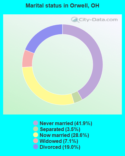
- Never married: 41.9%
- Now married: 28.6%
- Separated: 3.5%
- Widowed: 7.1%
- Divorced: 19.0%
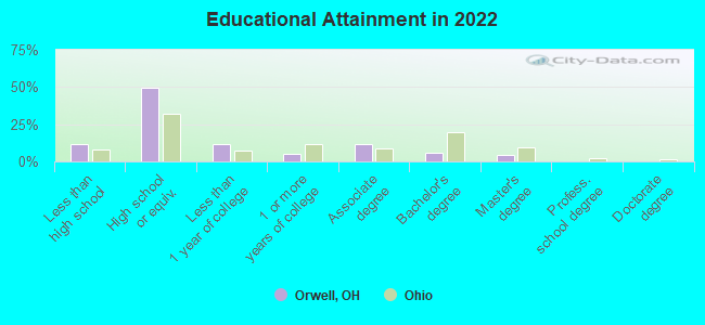
For population 25 years and over in Orwell:
- High school or higher: 87.4%
- Bachelor's degree or higher: 10.1%
- Graduate or professional degree: 3.3%
- Unemployed: 5.6%
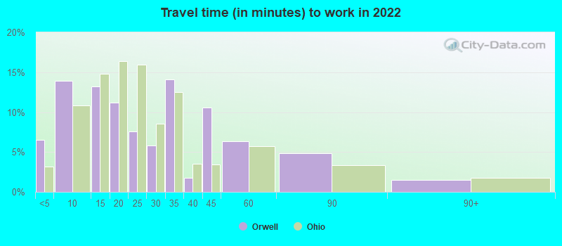
- Mean travel time to work (commute): 19.1 minutes
| Here: | 9.4 |
| Ohio average: | 11.0 |
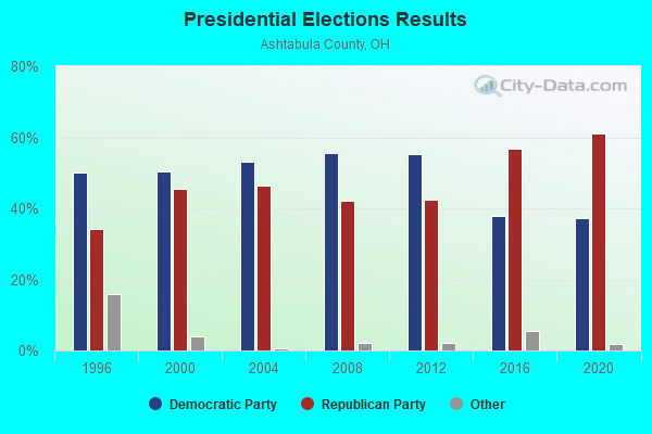
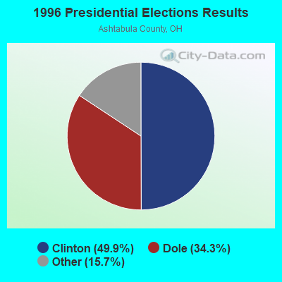
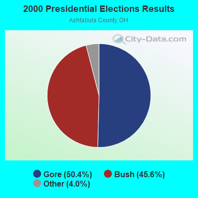
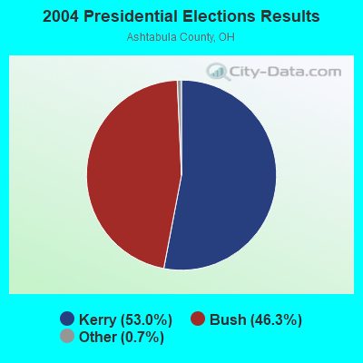

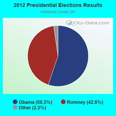
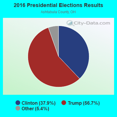
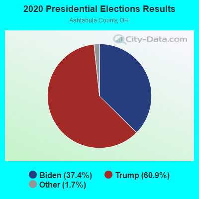
Graphs represent county-level data. Detailed 2008 Election Results
Religion statistics for Orwell, OH (based on Ashtabula County data)
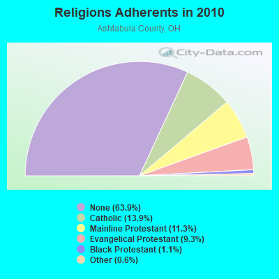
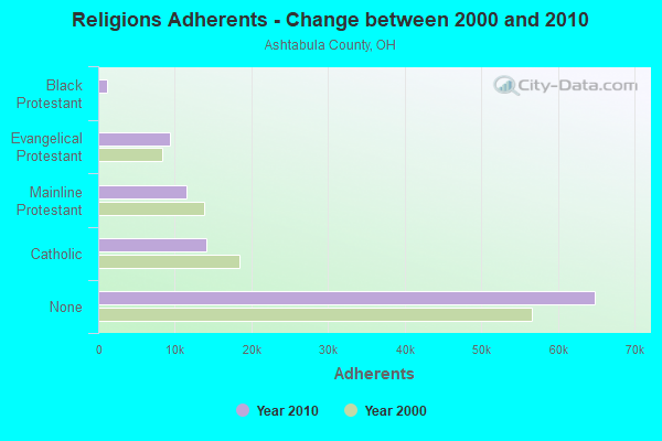
| Religion | Adherents | Congregations |
|---|---|---|
| Catholic | 14,134 | 11 |
| Mainline Protestant | 11,475 | 56 |
| Evangelical Protestant | 9,418 | 82 |
| Black Protestant | 1,097 | 4 |
| Other | 559 | 7 |
| None | 64,814 | - |
Food Environment Statistics:
| Ashtabula County: | 2.08 / 10,000 pop. |
| Ohio: | 1.89 / 10,000 pop. |
| Here: | 0.10 / 10,000 pop. |
| State: | 0.13 / 10,000 pop. |
| Ashtabula County: | 1.68 / 10,000 pop. |
| State: | 1.25 / 10,000 pop. |
| This county: | 3.16 / 10,000 pop. |
| State: | 2.93 / 10,000 pop. |
| Ashtabula County: | 7.71 / 10,000 pop. |
| Ohio: | 6.25 / 10,000 pop. |
| Ashtabula County: | 9.8% |
| State: | 10.3% |
| Here: | 29.5% |
| State: | 29.1% |
| This county: | 12.8% |
| Ohio: | 11.9% |
Health and Nutrition:
| Orwell: | 48.9% |
| State: | 50.4% |
| This city: | 45.5% |
| Ohio: | 47.8% |
| This city: | 29.5 |
| Ohio: | 28.7 |
| Here: | 23.7% |
| Ohio: | 20.6% |
| This city: | 13.9% |
| Ohio: | 10.4% |
| This city: | 6.8 |
| Ohio: | 6.8 |
| Orwell: | 37.6% |
| Ohio: | 34.3% |
| Orwell: | 55.5% |
| Ohio: | 57.0% |
| Orwell: | 77.6% |
| State: | 79.1% |
More about Health and Nutrition of Orwell, OH Residents
| Local government employment and payroll (March 2022) | |||||
| Function | Full-time employees | Monthly full-time payroll | Average yearly full-time wage | Part-time employees | Monthly part-time payroll |
|---|---|---|---|---|---|
| Other Government Administration | 6 | $4,792 | $9,584 | 0 | $0 |
| Police Protection - Officers | 5 | $14,776 | $35,462 | 2 | $1,098 |
| Sewerage | 2 | $8,554 | $51,324 | 0 | $0 |
| Streets and Highways | 2 | $6,067 | $36,402 | 0 | $0 |
| Water Supply | 1 | $3,056 | $36,672 | 0 | $0 |
| Financial Administration | 1 | $3,743 | $44,916 | 3 | $5,350 |
| Judicial and Legal | 0 | $0 | 1 | $2,701 | |
| Firefighters | 0 | $0 | 6 | $1,535 | |
| Totals for Government | 17 | $40,987 | $28,932 | 12 | $10,685 |
Orwell government finances - Expenditure in 2017 (per resident):
- Current Operations - General - Other: $615,000 ($403.54)
Police Protection: $428,000 ($280.84)
Sewerage: $375,000 ($246.06)
Water Utilities: $350,000 ($229.66)
Central Staff Services: $93,000 ($61.02)
Local Fire Protection: $82,000 ($53.81)
Regular Highways: $72,000 ($47.24)
Judicial and Legal Services: $35,000 ($22.97)
Financial Administration: $34,000 ($22.31)
Parks and Recreation: $3,000 ($1.97)
General Public Buildings: $2,000 ($1.31)
- General - Interest on Debt: $75,000 ($49.21)
- Intergovernmental to Local - Other - General - Other: $8,000 ($5.25)
Other - Health - Other: $5,000 ($3.28)
- Total Salaries and Wages: $590,000 ($387.14)
Orwell government finances - Revenue in 2017 (per resident):
- Charges - Sewerage: $317,000 ($208.01)
- Local Intergovernmental - General Local Government Support: $5,000 ($3.28)
- Miscellaneous - General Revenue - Other: $25,000 ($16.40)
- Revenue - Water Utilities: $328,000 ($215.22)
- State Intergovernmental - Highways: $166,000 ($108.92)
- Tax - Individual Income: $747,000 ($490.16)
Property: $79,000 ($51.84)
Corporation Net Income: $18,000 ($11.81)
Motor Vehicle License: $15,000 ($9.84)
Alcoholic Beverage License: $3,000 ($1.97)
Orwell government finances - Debt in 2017 (per resident):
- Long Term Debt - Beginning Outstanding - Unspecified Public Purpose: $1,882,000 ($1234.91)
Outstanding Unspecified Public Purpose: $1,797,000 ($1179.13)
Retired Unspecified Public Purpose: $84,000 ($55.12)
Orwell government finances - Cash and Securities in 2017 (per resident):
- Other Funds - Cash and Securities: $1,934,000 ($1269.03)
| Businesses in Orwell, OH | ||||
| Name | Count | Name | Count | |
|---|---|---|---|---|
| Chevrolet | 1 | Domino's Pizza | 1 | |
| Circle K | 1 | True Value | 1 | |
| Curves | 1 | UPS | 1 | |
| Dairy Queen | 1 | |||
Strongest AM radio stations in Orwell:
- WKNR (850 AM; 50 kW; CLEVELAND, OH; Owner: CARON BROADCASTING, INC.)
- WTAM (1100 AM; 50 kW; CLEVELAND, OH; Owner: JACOR BROADCASTING CORPORATION)
- WHK (1220 AM; 50 kW; CLEVELAND, OH; Owner: CARON BROADCASTING, INC.)
- WFUN (970 AM; 5 kW; ASHTABULA, OH; Owner: CLEAR CHANNEL BROADCASTING LICENSES, INC.)
- WKTX (830 AM; daytime; 1 kW; CORTLAND, OH; Owner: MIKLOS KOSSANYI, MARIA KOSSANYI)
- WNIO (1390 AM; 10 kW; YOUNGSTOWN, OH; Owner: YOUNGSTOWN RADIO LICENSE, L.L.C.)
- KDKA (1020 AM; 50 kW; PITTSBURGH, PA; Owner: INFINITY BROADCASTING OPERATIONS, INC.)
- WHKW (1440 AM; 5 kW; WARREN, OH; Owner: SCA LICENSE CORPORATION)
- WKBN (570 AM; 5 kW; YOUNGSTOWN, OH; Owner: CITICASTERS LICENSES, L.P.)
- WWVA (1170 AM; 53 kW; WHEELING, WV; Owner: CAPSTAR TX LIMITED PARTNERSHIP)
- WHBC (1480 AM; 15 kW; CANTON, OH; Owner: NM LICENSING, LLC)
- WWMK (1260 AM; 10 kW; CLEVELAND, OH; Owner: ABC, INC.)
- WJR (760 AM; 50 kW; DETROIT, MI; Owner: ABC, INC.)
Strongest FM radio stations in Orwell:
- WCVJ (90.9 FM; JEFFERSON, OH; Owner: AGAPE SCHOOL, INC.)
- WENZ (107.9 FM; CLEVELAND, OH; Owner: RADIO ONE LICENSES, LLC)
- WKSV (89.1 FM; THOMPSON, OH; Owner: KENT STATE UNIVERSITY)
- WMXY (98.9 FM; YOUNGSTOWN, OH; Owner: CITICASTERS LICENSES, L.P.)
- WREO-FM (97.1 FM; ASHTABULA, OH; Owner: CLEAR CHANNEL BROADCASTING LICENSES, INC.)
- WICT (95.1 FM; GROVE CITY, PA; Owner: YOUNGSTOWN RADIO LICENSE, L.L.C.)
- WMJI (105.7 FM; CLEVELAND, OH; Owner: CITICASTERS LICENSES, L.P.)
- WQAL (104.1 FM; CLEVELAND, OH; Owner: INFINITY RADIO OPERATIONS INC.)
- WBBG (106.1 FM; NILES, OH; Owner: CITICASTERS LICENSES, L.P.)
- WKHR (91.5 FM; BAINBRIDGE, OH; Owner: KENSTON LOCAL SCHOOL DISTRICT)
- WHOT-FM (101.1 FM; YOUNGSTOWN, OH; Owner: CUMULUS LICENSING CORP.)
- WZOO-FM (102.5 FM; EDGEWOOD, OH; Owner: CLEAR CHANNEL BROADCASTING LICENSES, INC.)
- WFHM-FM (95.5 FM; CLEVELAND, OH; Owner: SCA LICENSE CORPORATION)
- WYTN (91.7 FM; YOUNGSTOWN, OH; Owner: FAMILY STATIONS, INC.)
- WYFM (102.9 FM; SHARON, PA; Owner: CUMULUS LICENSING CORP.)
- WFXJ-FM (107.5 FM; NORTH KINGSVILLE, OH; Owner: CLEAR CHANNEL BROADCASTING LICENSES, INC.)
- WWIZ (103.9 FM; MERCER, PA; Owner: CUMULUS LICENSING CORP.)
- WKKY (104.7 FM; GENEVA, OH; Owner: MUSIC X-PRESS B/CNG CORP. OF NE OHIO)
TV broadcast stations around Orwell:
- WXOX-LP (Channel 65; CLEVELAND, OH; Owner: VENTURE TECHNOLOGIES GROUP, LLC)
- W53AX (Channel 53; CLEVELAND, OH; Owner: WORD OF GOD FELLOWSHIP, INC.)
- WKBN-TV (Channel 27; YOUNGSTOWN, OH; Owner: PIEDMONT TELEVISION OF YOUNGSTOWN LICENSE LLC)
- WFMJ-TV (Channel 21; YOUNGSTOWN, OH; Owner: WFMJ TELEVISION, INC.)
- W51BI (Channel 51; KIRTLAND, OH; Owner: TRINITY BROADCASTING NETWORK)
- WOIO (Channel 19; SHAKER HEIGHTS, OH; Owner: RAYCOM NATIONAL, INC.)
- WBNX-TV (Channel 55; AKRON, OH; Owner: WINSTON BROADCASTING NETWORK, INC.)
- W35AX (Channel 35; CLEVELAND, OH; Owner: MEDIA-COM TELEVISION, INC.)
- WYFX-LP (Channel 62; YOUNGSTOWN, OH; Owner: PIEDMONT TELEVISION OF YOUNGSTOWN LICENSE LLC)
- WFXI-CA (Channel 17; MERCER, PA; Owner: PIEDMONT TELEVISION OF YOUNGSTOWN LICENSE LLC)
- W63CT (Channel 63; EASTLAKE, ETC., OH; Owner: IDEASTREAM)
- WYTV (Channel 33; YOUNGSTOWN, OH; Owner: CHELSEY BROADCASTING COMPANY OF YOUNGSTOWN, LLC)
Orwell fatal accident list:
Jul 21, 2013 09:55 PM, Tr-76 Fenton Rd, Lat: 41.516953, Lon: -80.810253, Vehicles: 1, Persons: 2, Pedestrians: 3, Fatalities: 1
Aug 26, 2012 07:20 PM, Sr-45, Lat: 41.577872, Lon: -80.865489, Vehicles: 1, Persons: 1, Fatalities: 1
Feb 6, 2006 02:25 PM, Us-322, Lat: 41.535080, Lon: -80.839740, Vehicles: 2, Persons: 2, Fatalities: 1
Nov 12, 1999 04:33 PM, Chaffee Dr, Vehicles: 1, Persons: 2, Fatalities: 1
- National Bridge Inventory (NBI) Statistics
- 20Number of bridges
- 154ft / 46.6mTotal length
- $1,354,000Total costs
- 19,130Total average daily traffic
- 1,582Total average daily truck traffic
- 25,948Total future (year 2035) average daily traffic
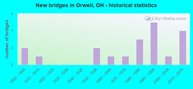
- New bridges - historical statistics
- 21900-1909
- 11910-1919
- 21950-1959
- 11960-1969
- 11970-1979
- 31980-1989
- 51990-1999
- 12000-2009
- 42010-2019
FCC Registered Cell Phone Towers:
1 (See the full list of FCC Registered Cell Phone Towers in Orwell)FCC Registered Antenna Towers:
29 (See the full list of FCC Registered Antenna Towers)FCC Registered Broadcast Land Mobile Towers:
3- Water Tower Behind School (Lat: 41.536722 Lon: -80.865083), Type: Tank, Structure height: 43 m, Call Sign: WPMC837,
Assigned Frequencies: 460.337 MHz, Grant Date: 03/20/2013, Expiration Date: 06/04/2023, Cancellation Date: 08/05/2023, Certifier: William R Johnson, Registrant: Communications Service, 250 Fairgrounds Rd, Painesville, OH 44077, Phone: (440) 354-3715, Fax: (440) 354-4302, Email:
- 150 Brand Valley Ave (Lat: 41.544167 Lon: -80.855278), Type: Bant, Structure height: 18.2 m, Overall height: 19.8 m, Call Sign: WPXG552,
Assigned Frequencies: 451.325 MHz, 451.850 MHz, 452.700 MHz, 463.675 MHz, Grant Date: 03/31/2003, Expiration Date: 03/31/2013, Cancellation Date: 06/01/2013, Certifier: Terry Phenicie, Registrant: Dennis R. Spaulding, Inc., 250 Fairgrounds Road, Painesville, OH 44077, Phone: (440) 354-3715, Fax: (440) 354-4302
- Lat: 41.543306 Lon: -80.858917, Call Sign: WRAJ824,
Assigned Frequencies: 464.012 MHz, 469.012 MHz, 464.112 MHz, 469.112 MHz, 469.162 MHz, Grant Date: 12/07/2017, Expiration Date: 12/07/2027, Certifier: John M Thomas, Registrant: Business Radio Licensing, 30251 Golden Lantern Ste E #501, Laguna Niguel, CA 92677, Phone: (949) 348-8510, Fax: (949) 348-8514, Email:
FCC Registered Microwave Towers:
5- WPA0273, 2627 Cream Ridge Rd. (Lat: 41.505750 Lon: -80.711917), Type: Gtower, Structure height: 91.4 m, Overall height: 97.5 m, Call Sign: WQSD317,
Assigned Frequencies: 11015.0 MHz, 11055.0 MHz, 6004.50 MHz, 6034.15 MHz, 11015.0 MHz, 11055.0 MHz, 6004.50 MHz, 6034.15 MHz, 11015.0 MHz, 11055.0 MHz... (+26 more), Grant Date: 09/19/2023, Expiration Date: 09/04/2033, Certifier: Brett Lindsey, Registrant: Micronet Communications, Inc., 812 Lexington Dr, Plano, TX 75075, Phone: (972) 422-7200, Email:
- COLEBROOK, 7941 State Route 46 (Lat: 41.533194 Lon: -80.763333), Type: Ltower, Structure height: 57.9 m, Overall height: 60.7 m, Call Sign: WQUA710,
Assigned Frequencies: 10975.0 MHz, 11095.0 MHz, Grant Date: 05/21/2014, Expiration Date: 05/21/2024, Certifier: John Monday, Registrant: At&t Services, Inc., 208 S Akard St, 20f, Dallas, TX 75202, Phone: (855) 699-7073, Email:
- ORWELL, 170-B North Maple Street (Lat: 41.542167 Lon: -80.859472), Type: Gtower, Structure height: 83.8 m, Overall height: 86.8 m, Call Sign: WQUE564,
Assigned Frequencies: 5945.20 MHz, 10915.0 MHz, Grant Date: 06/17/2014, Expiration Date: 06/17/2024, Cancellation Date: 12/12/2023, Certifier: Gregory M Romano, Registrant: Verizon, 5055 Northpointe Pkwy, Alpharetta, GA 30022, Phone: (770) 797-1070, Email:
- COLEBROOK, 7943 State Route 46 (Lat: 41.533139 Lon: -80.763778), Type: Ltower, Structure height: 57.9 m, Overall height: 60.6 m, Call Sign: WQVX394,
Assigned Frequencies: 6197.24 MHz, Grant Date: 06/04/2015, Expiration Date: 06/04/2025, Cancellation Date: 12/13/2023, Certifier: Gregory M Romano, Registrant: Verizon, 1300 I St Nw - Suite 500 East, Washington, DC 20005, Phone: (202) 515-2453, Email:
- CL97XC003, 4652 Sr322 (Lat: 41.534694 Lon: -80.916806), Type: Ltower, Structure height: 91.4 m, Overall height: 97.5 m, Call Sign: WQXH619,
Assigned Frequencies: 11525.0 MHz, Grant Date: 03/08/2016, Expiration Date: 03/08/2026, Cancellation Date: 05/11/2023, Certifier: Jenny Knopf, Registrant: T-Mobile Usa, Inc., 12920 Se 38th Street, Bellevue, WA 98006, Phone: (425) 383-8401, Email:
FCC Registered Paging Towers:
1- 70 South Maple Street (Lat: 41.533083 Lon: -80.868694), Call Sign: KLF475, Licensee ID: L00117476,
Assigned Frequencies: 152.540 MHz, Grant Date: 08/03/1998, Expiration Date: 07/01/2008, Cancellation Date: 01/14/2005, Registrant: The Orwell Telephone Company, 70 South Maple Street, Orwell, OH
FCC Registered Amateur Radio Licenses:
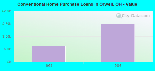
20 (See the full list of FCC Registered Amateur Radio Licenses in Orwell)| Home Mortgage Disclosure Act Aggregated Statistics For Year 2003 (Based on 1 partial tract) | ||||||
| B) Conventional Home Purchase Loans | C) Refinancings | D) Home Improvement Loans | ||||
|---|---|---|---|---|---|---|
| Number | Average Value | Number | Average Value | Number | Average Value | |
| LOANS ORIGINATED | 1 | $149,930 | 4 | $111,205 | 1 | $10,970 |
| APPLICATIONS APPROVED, NOT ACCEPTED | 0 | $0 | 1 | $93,140 | 0 | $0 |
| APPLICATIONS DENIED | 0 | $0 | 2 | $123,955 | 1 | $7,380 |
| APPLICATIONS WITHDRAWN | 0 | $0 | 2 | $100,540 | 0 | $0 |
| FILES CLOSED FOR INCOMPLETENESS | 0 | $0 | 0 | $0 | 0 | $0 |
Detailed HMDA statistics for the following Tracts: 0014.00

2003 - 2018 National Fire Incident Reporting System (NFIRS) incidents
- Fire incident types reported to NFIRS in Orwell, OH
- 26754.5%Structure Fires
- 17635.9%Outside Fires
- 479.6%Mobile Property/Vehicle Fires
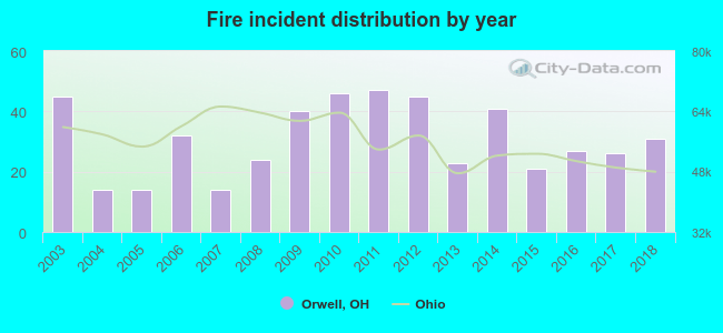 Based on the data from the years 2003 - 2018 the average number of fires per year is 31. The highest number of reported fire incidents - 47 took place in 2011, and the least - 14 in 2004. The data has a decreasing trend.
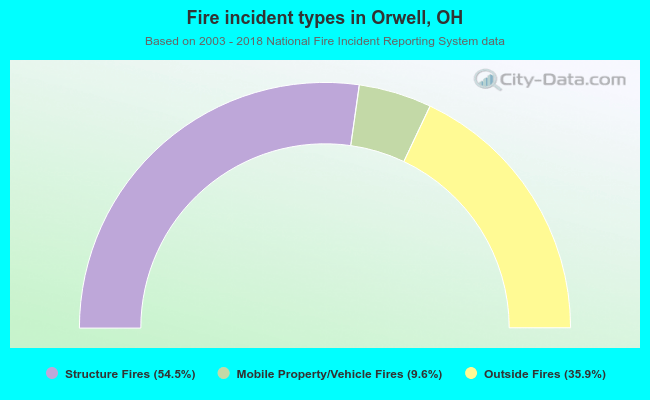 When looking into fire subcategories, the most reports belonged to: Structure Fires (54.5%), and Outside Fires (35.9%).
| Most common first names in Orwell, OH among deceased individuals | ||
| Name | Count | Lived (average) |
|---|---|---|
| John | 40 | 76.4 years |
| Mary | 23 | 79.4 years |
| William | 21 | 75.3 years |
| Frank | 20 | 74.2 years |
| Charles | 18 | 71.2 years |
| Robert | 16 | 72.1 years |
| Joseph | 16 | 79.0 years |
| George | 16 | 74.1 years |
| Richard | 15 | 70.5 years |
| Helen | 15 | 76.9 years |
| Most common last names in Orwell, OH among deceased individuals | ||
| Last name | Count | Lived (average) |
|---|---|---|
| Johnson | 10 | 73.3 years |
| Miller | 10 | 76.5 years |
| Slusher | 8 | 67.4 years |
| Hill | 7 | 79.0 years |
| Smith | 7 | 72.3 years |
| Williams | 7 | 73.6 years |
| Davis | 6 | 83.5 years |
| Hopes | 6 | 81.7 years |
| Mcelroy | 6 | 82.3 years |
| Taylor | 6 | 67.8 years |
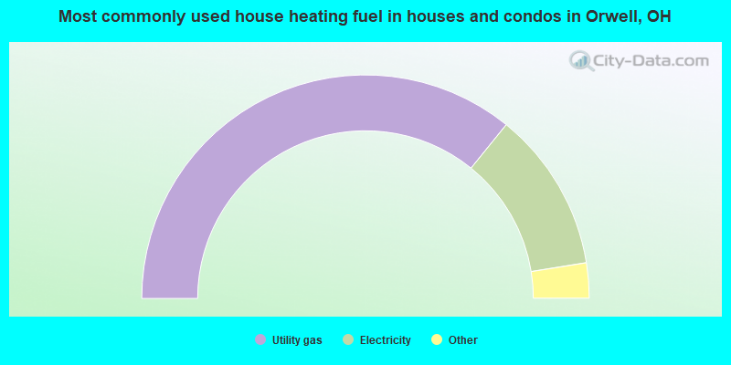
- 71.9%Utility gas
- 23.3%Electricity
- 3.5%Fuel oil, kerosene, etc.
- 0.6%Bottled, tank, or LP gas
- 0.6%No fuel used
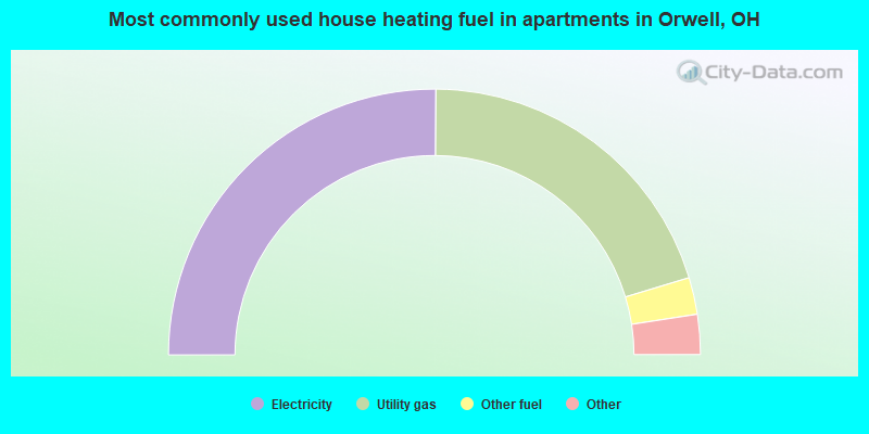
- 50.5%Electricity
- 40.7%Utility gas
- 4.5%Other fuel
- 3.2%Fuel oil, kerosene, etc.
- 0.8%Bottled, tank, or LP gas
- 0.3%Wood
Orwell compared to Ohio state average:
- Median household income below state average.
- Median house value below state average.
- Unemployed percentage below state average.
- Black race population percentage significantly below state average.
- Hispanic race population percentage significantly below state average.
- Median age below state average.
- Foreign-born population percentage significantly below state average.
- Length of stay since moving in significantly above state average.
- Number of rooms per house below state average.
- Percentage of population with a bachelor's degree or higher below state average.

|
|
Total of 33 patent applications in 2008-2024.