Princeton, Massachusetts

Princeton: Sunrise on Westminster Road, Princeton, MA

Princeton: Sunrise on Westminster Rd., Princeton, MA
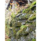
Princeton: Old Stone House on Wachusett Mountain, Princeton, MA
- add
your
Submit your own pictures of this town and show them to the world
- OSM Map
- General Map
- Google Map
- MSN Map
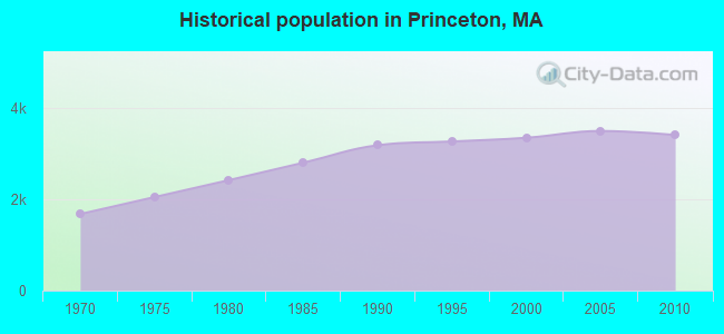
Population change since 2000: +1.8%
 |
| Males: 1,709 | |
| Females: 1,704 |
| Median resident age: | 46.8 years |
| Massachusetts median age: | 39.2 years |
Zip codes: 01541.
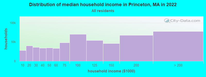
| Princeton: | $145,931 |
| MA: | $94,488 |
Estimated per capita income in 2022: $62,846 (it was $32,232 in 2000)
Princeton town income, earnings, and wages data
Estimated median house or condo value in 2022: $587,938 (it was $212,900 in 2000)
| Princeton: | $587,938 |
| MA: | $534,700 |
Mean prices in 2022: all housing units: $419,164; detached houses: $447,621; townhouses or other attached units: $343,592; in 2-unit structures: $323,295; in 3-to-4-unit structures: $332,295; in 5-or-more-unit structures: $232,758; mobile homes: $113,885
Detailed information about poverty and poor residents in Princeton, MA


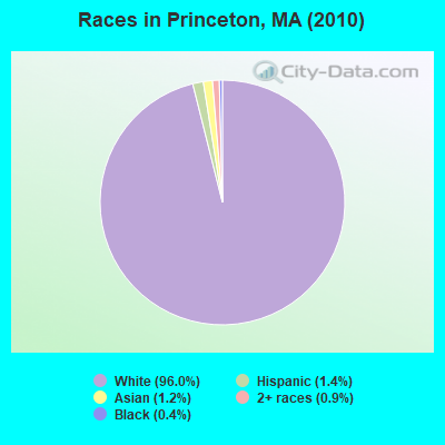
- 3,27796.0%White alone
- 491.4%Hispanic
- 401.2%Asian alone
- 320.9%Two or more races
- 140.4%Black alone
- 10.03%American Indian alone
Races in Princeton detailed stats: ancestries, foreign born residents, place of birth
Type |
2009 |
2010 |
2011 |
2012 |
2013 |
2014 |
2015 |
2016 |
2017 |
2018 |
2019 |
2020 |
2021 |
2022 |
|---|---|---|---|---|---|---|---|---|---|---|---|---|---|---|
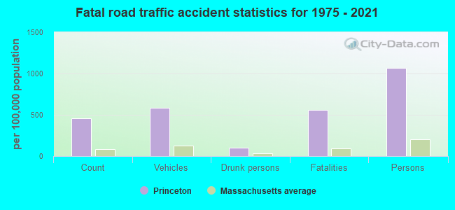
| Murders (per 100,000) | 0 (0.0) | 0 (0.0) | 0 (0.0) | 0 (0.0) | 0 (0.0) | 0 (0.0) | 0 (0.0) | 1 (28.9) | 0 (0.0) | 0 (0.0) | 0 (0.0) | 0 (0.0) | 0 (0.0) | 0 (0.0) |
| Rapes (per 100,000) | 0 (0.0) | 0 (0.0) | 1 (29.1) | 0 (0.0) | 1 (29.0) | 0 (0.0) | 0 (0.0) | 0 (0.0) | 0 (0.0) | 0 (0.0) | 0 (0.0) | 0 (0.0) | 1 (28.4) | 2 (56.8) |
| Robberies (per 100,000) | 0 (0.0) | 0 (0.0) | 0 (0.0) | 0 (0.0) | 0 (0.0) | 0 (0.0) | 0 (0.0) | 0 (0.0) | 0 (0.0) | 0 (0.0) | 0 (0.0) | 0 (0.0) | 0 (0.0) | 0 (0.0) |
| Assaults (per 100,000) | 1 (28.3) | 1 (29.3) | 1 (29.1) | 1 (29.0) | 6 (173.8) | 0 (0.0) | 2 (58.0) | 2 (57.7) | 1 (28.8) | 0 (0.0) | 1 (28.9) | 0 (0.0) | 1 (28.4) | 3 (85.2) |
| Burglaries (per 100,000) | 15 (424.2) | 24 (703.2) | 13 (378.6) | 28 (810.7) | 14 (405.6) | 17 (492.6) | 16 (463.6) | 5 (144.3) | 4 (115.2) | 2 (57.8) | 3 (86.7) | 3 (86.3) | 3 (85.2) | 2 (56.8) |
| Thefts (per 100,000) | 17 (480.8) | 13 (380.9) | 17 (495.0) | 14 (405.3) | 17 (492.5) | 6 (173.9) | 11 (318.7) | 13 (375.2) | 12 (345.6) | 5 (144.6) | 10 (289.1) | 7 (201.3) | 12 (340.7) | 5 (142.0) |
| Auto thefts (per 100,000) | 0 (0.0) | 1 (29.3) | 0 (0.0) | 1 (29.0) | 1 (29.0) | 3 (86.9) | 0 (0.0) | 0 (0.0) | 1 (28.8) | 0 (0.0) | 0 (0.0) | 2 (57.5) | 3 (85.2) | 1 (28.4) |
| Arson (per 100,000) | 0 (0.0) | 1 (29.3) | 1 (29.1) | 0 (0.0) | 0 (0.0) | 0 (0.0) | 0 (0.0) | 0 (0.0) | 0 (0.0) | 0 (0.0) | 0 (0.0) | 0 (0.0) | 0 (0.0) | 0 (0.0) |
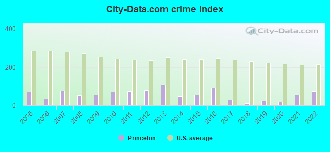
| City-Data.com crime index | 54.6 | 72.7 | 75.4 | 81.1 | 108.3 | 48.4 | 56.8 | 94.4 | 30.0 | 9.8 | 23.4 | 18.7 | 54.8 | 74.4 |
The City-Data.com crime index weighs serious crimes and violent crimes more heavily. Higher means more crime, U.S. average is 246.1. It adjusts for the number of visitors and daily workers commuting into cities.
Crime rate in Princeton detailed stats: murders, rapes, robberies, assaults, burglaries, thefts, arson
Full-time law enforcement employees in 2021, including police officers: 7 (6 officers - 4 male; 2 female).
| Officers per 1,000 residents here: | 1.70 |
| Massachusetts average: | 2.53 |
 Recent articles from our blog. Our writers, many of them Ph.D. graduates or candidates, create easy-to-read articles on a wide variety of topics.

 | Acton or…? (77 replies) |
| Post homes in MA that people like (55 replies) |
| Central or Western MA towns for Seniors (16 replies) |
| Moving to MA from out of state - figuring out how to pick the "right" suburb for me and my family (81 replies) |
| Buying a house in Sterling, MA (51 replies) |
| Catskills Like Towns in Mass? (52 replies) |
Latest news from Princeton, MA collected exclusively by city-data.com from local newspapers, TV, and radio stations
Princeton, MA City Guides:
Ancestries: English (21.7%), Irish (19.4%), French (10.7%), Italian (10.4%), German (9.8%), Polish (9.2%).
Current Local Time: EST time zone
Incorporated in 1771
Elevation: 1175 feet
Land area: 35.4 square miles.
Population density: 96 people per square mile (very low).
164 residents are foreign born (2.2% Europe, 1.1% North America, 1.1% Asia).
| This town: | 4.9% |
| Massachusetts: | 12.2% |
| Princeton town: | 1.3% ($2,736) |
| Massachusetts: | 1.3% ($2,336) |
Nearest city with pop. 50,000+: Worcester, MA  (13.3 miles , pop. 172,648).
Nearest city with pop. 200,000+: Boston, MA (41.5 miles , pop. 589,141).
Nearest city with pop. 1,000,000+: Bronx, NY (151.4 miles , pop. 1,332,650).
Nearest cities:
Latitude: 42.45 N, Longitude: 71.88 W
Area code: 978

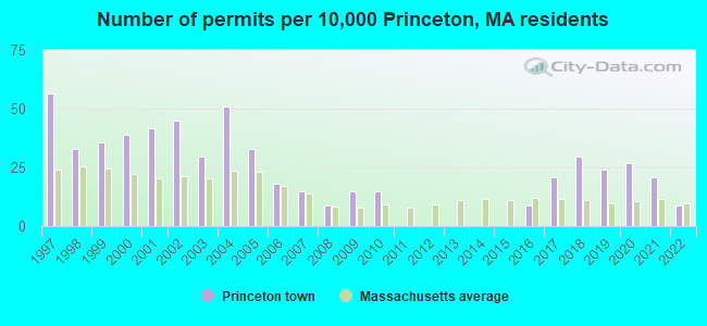
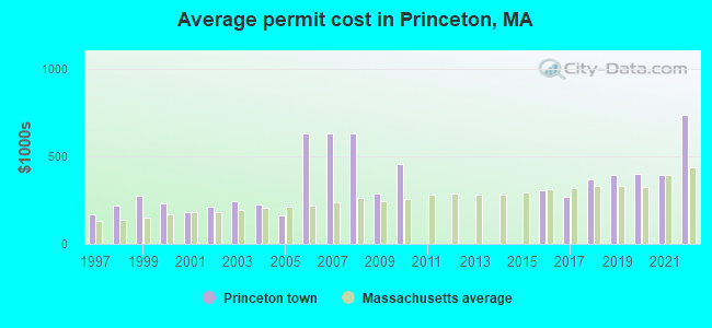
Single-family new house construction building permits:
- 2022: 3 buildings, average cost: $736,000
- 2021: 7 buildings, average cost: $394,300
- 2020: 9 buildings, average cost: $402,300
- 2019: 8 buildings, average cost: $393,600
- 2018: 10 buildings, average cost: $366,800
- 2017: 7 buildings, average cost: $267,000
- 2016: 3 buildings, average cost: $306,600
- 2010: 5 buildings, average cost: $454,200
- 2009: 5 buildings, average cost: $290,000
- 2008: 3 buildings, average cost: $632,500
- 2007: 5 buildings, average cost: $632,500
- 2006: 6 buildings, average cost: $632,500
- 2005: 11 buildings, average cost: $160,600
- 2004: 17 buildings, average cost: $222,500
- 2003: 10 buildings, average cost: $242,900
- 2002: 15 buildings, average cost: $214,600
- 2001: 14 buildings, average cost: $181,000
- 2000: 13 buildings, average cost: $231,100
- 1999: 12 buildings, average cost: $277,000
- 1998: 11 buildings, average cost: $217,100
- 1997: 19 buildings, average cost: $170,900
| Here: | 2.7% |
| Massachusetts: | 3.5% |
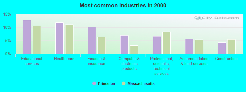
- Educational services (12.8%)
- Health care (11.9%)
- Finance & insurance (10.3%)
- Computer & electronic products (7.0%)
- Professional, scientific, technical services (6.7%)
- Accommodation & food services (5.7%)
- Construction (4.3%)
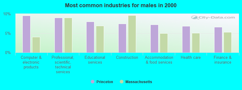
- Computer & electronic products (9.5%)
- Professional, scientific, technical services (9.0%)
- Educational services (8.0%)
- Construction (7.4%)
- Accommodation & food services (7.2%)
- Health care (6.8%)
- Finance & insurance (6.6%)
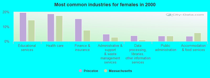
- Educational services (19.6%)
- Health care (18.8%)
- Finance & insurance (15.4%)
- Administrative & support & waste management services (5.0%)
- Data processing, libraries, other information services (3.8%)
- Public administration (3.7%)
- Accommodation & food services (3.5%)
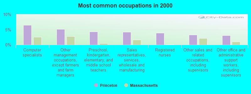
- Computer specialists (6.5%)
- Other management occupations, except farmers and farm managers (5.2%)
- Preschool, kindergarten, elementary, and middle school teachers (4.4%)
- Sales representatives, services, wholesale and manufacturing (4.2%)
- Registered nurses (3.9%)
- Other sales and related occupations, including supervisors (3.3%)
- Other office and administrative support workers, including supervisors (3.1%)
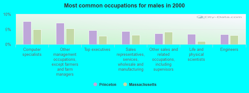
- Computer specialists (7.6%)
- Other management occupations, except farmers and farm managers (7.1%)
- Top executives (4.7%)
- Sales representatives, services, wholesale and manufacturing (4.4%)
- Other sales and related occupations, including supervisors (3.6%)
- Life and physical scientists (3.4%)
- Engineers (3.3%)
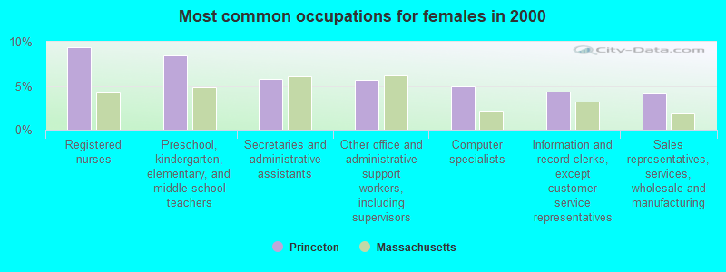
- Registered nurses (9.3%)
- Preschool, kindergarten, elementary, and middle school teachers (8.4%)
- Secretaries and administrative assistants (5.8%)
- Other office and administrative support workers, including supervisors (5.7%)
- Computer specialists (5.0%)
- Information and record clerks, except customer service representatives (4.3%)
- Sales representatives, services, wholesale and manufacturing (4.1%)
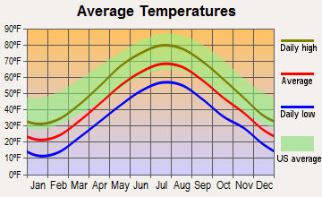
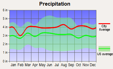
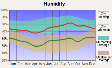
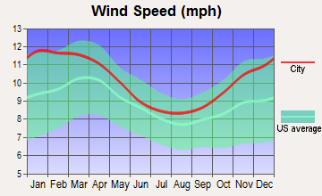
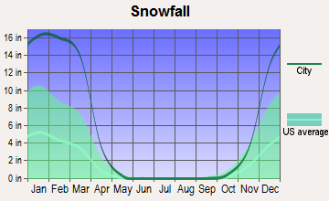
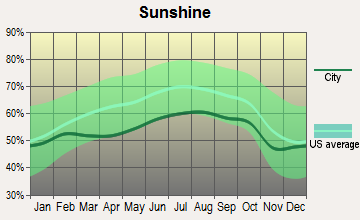
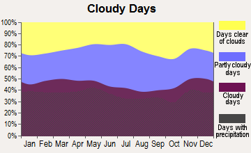
Average climate in Princeton, Massachusetts
Based on data reported by over 4,000 weather stations
(lower is better)
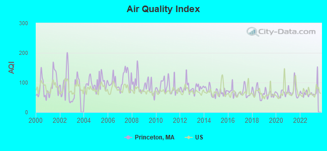
Air Quality Index (AQI) level in 2022 was 62.5. This is about average.
| City: | 62.5 |
| U.S.: | 72.6 |
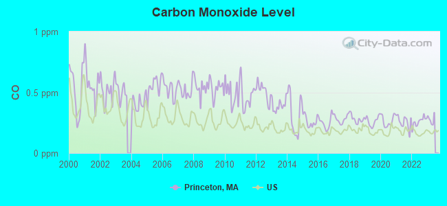
Carbon Monoxide (CO) [ppm] level in 2022 was 0.259. This is about average. Closest monitor was 13.4 miles away from the city center.
| City: | 0.259 |
| U.S.: | 0.251 |
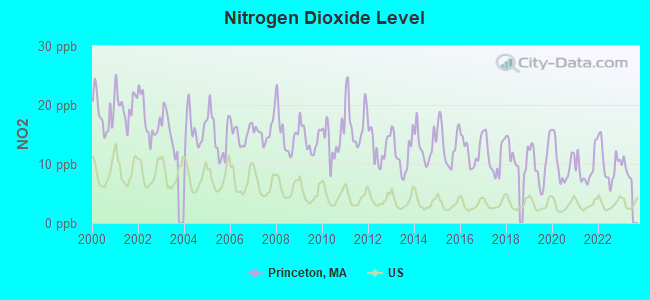
Nitrogen Dioxide (NO2) [ppb] level in 2022 was 10.1. This is significantly worse than average. Closest monitor was 9.7 miles away from the city center.
| City: | 10.1 |
| U.S.: | 5.1 |
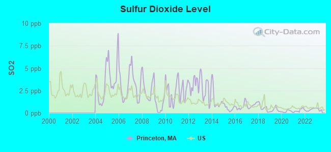
Sulfur Dioxide (SO2) [ppb] level in 2022 was 0.370. This is significantly better than average. Closest monitor was 8.3 miles away from the city center.
| City: | 0.370 |
| U.S.: | 1.515 |
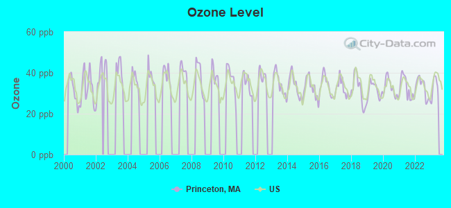
Ozone [ppb] level in 2022 was 32.4. This is about average. Closest monitor was 9.7 miles away from the city center.
| City: | 32.4 |
| U.S.: | 33.3 |
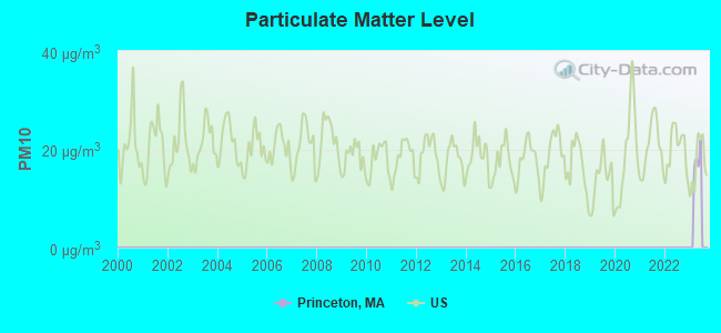
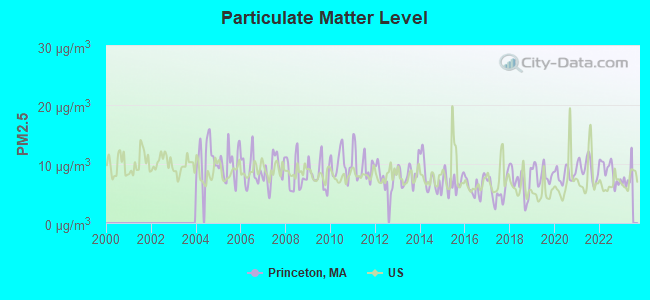
Particulate Matter (PM2.5) [µg/m3] level in 2022 was 8.71. This is about average. Closest monitor was 11.0 miles away from the city center.
| City: | 8.71 |
| U.S.: | 8.11 |
Tornado activity:
Princeton-area historical tornado activity is slightly above Massachusetts state average. It is 17% smaller than the overall U.S. average.
On 6/9/1953, a category F4 (max. wind speeds 207-260 mph) tornado 14.8 miles away from the Princeton town center killed 90 people and injured 1228 people and caused between $50,000,000 and $500,000,000 in damages.
On 6/22/1981, a category F3 (max. wind speeds 158-206 mph) tornado 6.9 miles away from the town center injured 3 people and caused between $5000 and $50,000 in damages.
Earthquake activity:
Princeton-area historical earthquake activity is significantly above Massachusetts state average. It is 71% smaller than the overall U.S. average.On 10/7/1983 at 10:18:46, a magnitude 5.3 (5.1 MB, 5.3 LG, 5.1 ML, Class: Moderate, Intensity: VI - VII) earthquake occurred 161.8 miles away from Princeton center
On 4/20/2002 at 10:50:47, a magnitude 5.3 (5.3 ML, Depth: 3.0 mi) earthquake occurred 169.2 miles away from Princeton center
On 4/20/2002 at 10:50:47, a magnitude 5.2 (5.2 MB, 4.2 MS, 5.2 MW, 5.0 MW) earthquake occurred 168.3 miles away from Princeton center
On 1/19/1982 at 00:14:42, a magnitude 4.7 (4.5 MB, 4.7 MD, 4.5 LG, Class: Light, Intensity: IV - V) earthquake occurred 73.9 miles away from the city center
On 10/16/2012 at 23:12:25, a magnitude 4.7 (4.7 ML, Depth: 10.0 mi) earthquake occurred 100.6 miles away from the city center
On 10/2/1994 at 11:27:22, a magnitude 3.7 (3.5 LG, 3.7 LG, Depth: 6.2 mi, Class: Light, Intensity: II - III) earthquake occurred 21.4 miles away from Princeton center
Magnitude types: regional Lg-wave magnitude (LG), body-wave magnitude (MB), duration magnitude (MD), local magnitude (ML), surface-wave magnitude (MS), moment magnitude (MW)
Natural disasters:
The number of natural disasters in Worcester County (27) is a lot greater than the US average (15).Major Disasters (Presidential) Declared: 15
Emergencies Declared: 12
Causes of natural disasters: Floods: 9, Storms: 8, Hurricanes: 6, Snowstorms: 5, Winter Storms: 4, Blizzards: 2, Snows: 2, Fire: 1, Heavy Rain: 1, Snowfall: 1, Tornado: 1, Wind: 1 (Note: some incidents may be assigned to more than one category).
Hospitals and medical centers near Princeton:
- STERLING VILLAGE (Nursing Home, about 6 miles away; STERLING, MA)
- OAKDALE NURSING HOME (Nursing Home, about 6 miles away; WEST BOYLSTON, MA)
- OAKDALE REHABILITATION AND SKILLED NURSING CENTER (Nursing Home, about 7 miles away; WEST BOYLSTON, MA)
- RUTLAND HEIGHTS HOSP- SNF (Nursing Home, about 7 miles away; RUTLAND, MA)
- MEDICAL CTR OF CENTRAL MASS-HOLDEN (Hospital, about 8 miles away; HOLDEN, MA)
- WACHUSETT EXTENDED CARE FACILITY (Nursing Home, about 8 miles away; HOLDEN, MA)
- HOLDEN NURSING HOME (Nursing Home, about 8 miles away; HOLDEN, MA)
Amtrak station near Princeton:
Colleges/universities with over 2000 students nearest to Princeton:
- Quinsigamond Community College (about 11 miles; Worcester, MA; Full-time enrollment: 5,877)
- Fitchburg State University (about 11 miles; Fitchburg, MA; FT enrollment: 5,010)
- Mount Wachusett Community College (about 12 miles; Gardner, MA; FT enrollment: 3,143)
- Assumption College (about 12 miles; Worcester, MA; FT enrollment: 2,580)
- Worcester Polytechnic Institute (about 13 miles; Worcester, MA; FT enrollment: 3,930)
- Worcester State University (about 13 miles; Worcester, MA; FT enrollment: 5,426)
- Clark University (about 15 miles; Worcester, MA; FT enrollment: 3,687)
Public elementary/middle school in Princeton:
- THOMAS PRINCE (Students: 436, Location: 170 STERLING ROAD, Grades: KG-8)
Points of interest:
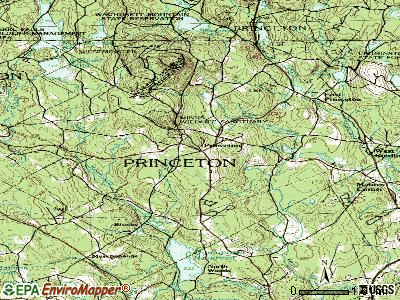
Notable locations in Princeton: Norco Sportsmens Club (A), Princeton Station (B), Wachusett Mountain Ski Area (C), Princeton Fire Department Westminister (D), Princeton Fire Department (E), Princetonw Town Hall (F), Princeton Public Library (G). Display/hide their locations on the map
Churches in Princeton include: Princeton First Congregational Church (A), Prince of Peace Parish Church (B). Display/hide their locations on the map
Cemeteries: South Cemetery (1), West Sterling Cemetery (2), Woodlawn Cemetery (3), West Cemetery (4). Display/hide their locations on the map
Lakes and reservoirs: Glutner Pond (A), Paradise Pond (B), Snow Pond (C), Crow Hills Pond (D). Display/hide their locations on the map
Streams, rivers, and creeks: Cobb Brook (A), South Wachusett Brook (B), West Wachusett Brook (C), Babcock Brook (D), Bailey Brook (E), Washburn Brook (F). Display/hide their locations on the map
Parks in Princeton include: Wachusett Mountain State Reservation (1), Minns Wildlife Sanctuary (2), Wachusett Meadow Wildlife Sanctuary (3). Display/hide their locations on the map
Birthplace of: Leonard B. Chandler - Politician, Charles Theodore Russell - Politician.
| This town: | 2.7 people |
| Massachusetts: | 2.5 people |
| This town: | 79.2% |
| Whole state: | 63.0% |
| This town: | 5.2% |
| Whole state: | 7.0% |
Likely homosexual households (counted as self-reported same-sex unmarried-partner households)
- Lesbian couples: 0.5% of all households
- Gay men: 0.5% of all households
| This town: | 4.4% |
| Whole state: | 9.3% |
| This town: | 1.5% |
| Whole state: | 4.4% |
Banks with branches in Princeton (2011 data):
- Barre Savings Bank: Princeton Branch at 206 Worcester Road, branch established on 1997/08/21. Info updated 2008/03/03: Bank assets: $144.3 mil, Deposits: $108.5 mil, headquarters in Barre, MA, positive income, Mortgage Lending Specialization, 3 total offices
For population 15 years and over in Princeton:
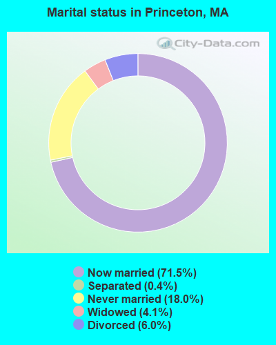
- Never married: 18.0%
- Now married: 71.5%
- Separated: 0.4%
- Widowed: 4.1%
- Divorced: 6.0%
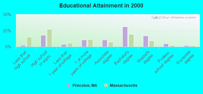
For population 25 years and over in Princeton:
- High school or higher: 97.7%
- Bachelor's degree or higher: 54.8%
- Graduate or professional degree: 23.9%
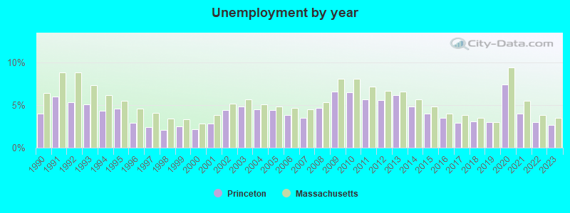
- Unemployed: 2.7%
- Mean travel time to work (commute): 31.2 minutes
| Here: | 9.2 |
| Massachusetts average: | 13.1 |


Graphs represent county-level data. Detailed 2008 Election Results
Religion statistics for Princeton, MA (based on Worcester County data)


| Religion | Adherents | Congregations |
|---|---|---|
| Catholic | 306,925 | 118 |
| Mainline Protestant | 43,326 | 171 |
| Evangelical Protestant | 37,511 | 203 |
| Other | 18,931 | 69 |
| Orthodox | 7,935 | 15 |
| Black Protestant | 497 | 6 |
| None | 383,427 | - |
Food Environment Statistics:
| This county: | 1.73 / 10,000 pop. |
| Massachusetts: | 1.98 / 10,000 pop. |
| Worcester County: | 0.05 / 10,000 pop. |
| Massachusetts: | 0.05 / 10,000 pop. |
| Here: | 1.79 / 10,000 pop. |
| State: | 2.22 / 10,000 pop. |
| This county: | 2.22 / 10,000 pop. |
| State: | 1.77 / 10,000 pop. |
| This county: | 7.27 / 10,000 pop. |
| Massachusetts: | 8.76 / 10,000 pop. |
| Worcester County: | 8.0% |
| Massachusetts: | 8.1% |
| Worcester County: | 24.0% |
| State: | 22.5% |
| Here: | 16.6% |
| Massachusetts: | 16.5% |
4.71% of this county's 2021 resident taxpayers lived in other counties in 2020 ($76,229 average adjusted gross income)
| Here: | 4.71% |
| Massachusetts average: | 6.35% |
0.02% of residents moved from foreign countries ($100 average AGI)
Worcester County: 0.02% Massachusetts average: 0.01%
Top counties from which taxpayers relocated into this county between 2020 and 2021:
| from Middlesex County, MA | |
| from Norfolk County, MA | |
| from Suffolk County, MA |
4.84% of this county's 2020 resident taxpayers moved to other counties in 2021 ($87,252 average adjusted gross income)
| Here: | 4.84% |
| Massachusetts average: | 7.18% |
0.03% of residents moved to foreign countries ($199 average AGI)
Worcester County: 0.03% Massachusetts average: 0.02%
Top counties to which taxpayers relocated from this county between 2020 and 2021:
| to Middlesex County, MA | |
| to Norfolk County, MA | |
| to Suffolk County, MA |
Strongest AM radio stations in Princeton:
- WCRN (830 AM; 50 kW; WORCESTER, MA; Owner: CARTER BROADCASTING CORPORATION)
- WTAG (580 AM; 5 kW; WORCESTER, MA; Owner: CAPSTAR TX LIMITED PARTNERSHIP)
- WVNE (760 AM; daytime; 25 kW; LEICESTER, MA; Owner: BLOUNT MASSCOM, INC.)
- WKOX (1200 AM; 50 kW; FRAMINGHAM, MA; Owner: CAPSTAR TX LIMITED PARTNERSHIP)
- WRKO (680 AM; 50 kW; BOSTON, MA; Owner: ENTERCOM BOSTON LICENSE, LLC)
- WBIX (1060 AM; 40 kW; NATICK, MA; Owner: LANGER BROADCASTING CORPORATION)
- WEEI (850 AM; 50 kW; BOSTON, MA; Owner: ENTERCOM BOSTON LICENSE, LLC)
- WEIM (1280 AM; 5 kW; FITCHBURG, MA; Owner: LIVEAIR COMMUNICATIONS, INC.)
- WAMG (890 AM; 25 kW; DEDHAM, MA; Owner: MEGA COMMUNICATIONS OF DEDHAM LICENSEE, LLC)
- WALE (990 AM; 50 kW; GREENVILLE, RI; Owner: NORTH AMERICAN BROADCASTING CO., INC.)
- WNNZ (640 AM; 50 kW; WESTFIELD, MA; Owner: CLEAR CHANNEL BROADCASTING LICENSES, INC.)
- WVEI (1440 AM; 5 kW; WORCESTER, MA; Owner: ENTERCOM BOSTON LICENSE, LLC)
- WWZN (1510 AM; 50 kW; BOSTON, MA; Owner: ROSE CITY RADIO CORPORATION)
Strongest FM radio stations in Princeton:
- WXLO (104.5 FM; FITCHBURG, MA; Owner: CITADEL BROADCASTING COMPANY)
- WAAF (107.3 FM; WORCESTER, MA; Owner: ENTERCOM BOSTON LICENSE, LLC)
- WSRS (96.1 FM; WORCESTER, MA; Owner: CAPSTAR TX LIMITED PARTNERSHIP)
- WFEX (92.1 FM; PETERBOROUGH, NH; Owner: FNX BROADCASTING OF NEW HAMPSHIRE LLC)
- WAHL (99.9 FM; ATHOL, MA; Owner: CITADEL BROADCASTING COMPANY)
- WFCR (88.5 FM; AMHERST, MA; Owner: UNIVERSITY OF MASSACHUSETTS)
- WICN (90.5 FM; WORCESTER, MA; Owner: WICN PUBLIC RADIO, INC)
- WBMX (98.5 FM; BOSTON, MA; Owner: INFINITY RADIO OPERATIONS INC.)
- WJMN (94.5 FM; BOSTON, MA; Owner: AMFM RADIO LICENSES, L.L.C.)
- WCRB (102.5 FM; WALTHAM, MA; Owner: CHARLES RIVER BROADCASTING WCRB LICE)
- WTKK (96.9 FM; BOSTON, MA; Owner: GREATER BOSTON RADIO, INC.)
- WROR-FM (105.7 FM; FRAMINGHAM, MA; Owner: GREATER BOSTON RADIO, INC.)
- WBOS (92.9 FM; BROOKLINE, MA; Owner: GREATER BOSTON RADIO, INC.)
- WGBH (89.7 FM; BOSTON, MA; Owner: WGBH EDUCATIONAL FOUNDATION)
- WBPR (91.9 FM; WORCESTER, MA; Owner: UNIVERSITY OF MASSACHUSETTS)
- WBUR-FM (90.9 FM; BOSTON, MA; Owner: TRUSTEES OF BOSTON UNIVERSITY)
- WINQ (97.7 FM; WINCHENDON, MA; Owner: SAGA COMMUNICATIONS OF NEW ENGLAND, LLC)
- WAMH (89.3 FM; AMHERST, MA; Owner: TRUSTEES OF AMHERST COLLEGE)
- WXKS-FM (107.9 FM; MEDFORD, MA; Owner: AMFM RADIO LICENSES, L.L.C.)
- WMJX (106.7 FM; BOSTON, MA; Owner: GREATER BOSTON RADIO, INC.)
TV broadcast stations around Princeton:
- WUNI (Channel 27; WORCESTER, MA; Owner: ENTRAVISION HOLDINGS, LLC)
- WUTF (Channel 66; MARLBOROUGH, MA; Owner: TELEFUTURA BOSTON LLC)
- WCVB-TV (Channel 5; BOSTON, MA; Owner: WCVB HEARST-ARGYLE TV, INC.)
- WYDN (Channel 48; WORCESTER, MA; Owner: EDUCATIONAL PUBLIC TV CORPORATION)
- WGBH-TV (Channel 2; BOSTON, MA; Owner: WGBH EDUCATIONAL FOUNDATION)
- WHDH-TV (Channel 7; BOSTON, MA; Owner: WHDH-TV)
- WMFP (Channel 62; LAWRENCE, MA; Owner: WSAH LICENSE, INC.)
- WBZ-TV (Channel 4; BOSTON, MA; Owner: VIACOM INC.)
- WGBX-TV (Channel 44; BOSTON, MA; Owner: WGBH EDUCATIONAL FOUNDATION)
- WSBK-TV (Channel 38; BOSTON, MA; Owner: VIACOM INC.)
- WLVI-TV (Channel 56; CAMBRIDGE, MA; Owner: WLVI, INC.)
- WFXT (Channel 25; BOSTON, MA; Owner: FOX TELEVISION STATIONS INC.)
- WCRN-LP (Channel 34; LEICESTER, MA; Owner: CARTER BROADCASTING CORPORATION)
- W40BO (Channel 40; BOSTON, MA; Owner: PAXSON COMMUNICATIONS LPTV, INC.)
- WBPX (Channel 68; BOSTON, MA; Owner: PAXSON BOSTON-68 LICENSE, INC.)
- WFXZ-CA (Channel 24; BOSTON, MA; Owner: BOSTON BROADCASTING CORP.)
- National Bridge Inventory (NBI) Statistics
- 8Number of bridges
- 33ft / 10.0mTotal length
- $6,625,000Total costs
- 12,277Total average daily traffic
- 965Total average daily truck traffic
FCC Registered Antenna Towers:
14 (See the full list of FCC Registered Antenna Towers in Princeton)FCC Registered Broadcast Land Mobile Towers:
7- Mt Wachuset (Lat: 42.321194 Lon: -71.882861), Call Sign: KCF838, Licensee ID: L00003516,
Assigned Frequencies: 45.3600 MHz, Grant Date: 03/01/2005, Expiration Date: 05/28/2015, Cancellation Date: 08/01/2015, Registrant: Commonwealth Of Massachusetts, 400 Worcester Rd, Framingham, MA 01702-5399, Phone: (508) 820-2023, Fax: (508) 875-2517, Email:
- Wachusetts Mountain (Lat: 42.487861 Lon: -71.882861), Call Sign: KVN528,
Assigned Frequencies: 45.3200 MHz, Grant Date: 05/02/2023, Expiration Date: 05/11/2033, Registrant: Commonwealth Of Massachusetts, 400 Worcester Rd, Framingham, MA 01702, Phone: (508) 820-2009, Fax: (508) 875-2517, Email:
- Summit Of Mount Wachussetts (Lat: 42.487861 Lon: -71.882861), Structure height: 30 m, Call Sign: WNYS577,
Assigned Frequencies: 72.8600 MHz, Grant Date: 12/16/2011, Expiration Date: 03/09/2022, Cancellation Date: 03/03/2022, Registrant: Massdot, 10 Park Plaza; Suite 7410, Boston, MA 02116, Phone: (617) 835-6922, Email:
- Rear Town Hall Mun Light Plant (Lat: 42.443139 Lon: -71.878972), Call Sign: KCF702, Licensee ID: L00094605,
Assigned Frequencies: 48.3800 MHz, Grant Date: 10/30/2002, Expiration Date: 12/08/2012, Cancellation Date: 02/09/2013, Registrant: Princeton, Town Of, 4 Town Hall Dr, Princeton, MA 01541
- Mountain Rd (Lat: 42.491472 Lon: -71.879806), Type: Pole, Structure height: 9 m, Overall height: 14 m, Call Sign: WPKG341,
Assigned Frequencies: 47.9600 MHz, 48.2200 MHz, 48.4400 MHz, 49.1800 MHz, 47.8800 MHz, Grant Date: 12/23/2021, Expiration Date: 02/11/2032, Certifier: Neil D Deegan, Registrant: Utilities Technology Council, 2550 South Clark St., Suite 960, Arlington, VA 22202, Phone: (202) 872-0030, Fax: (202) 872-1331, Email:
- Mt Wachusett State Park (Lat: 42.488611 Lon: -71.887222), Type: Tower, Structure height: 20 m, Overall height: 26 m, Call Sign: WPSJ338,
Assigned Frequencies: 851.012 MHz, 851.512 MHz, 852.012 MHz, 852.512 MHz, 853.012 MHz, Grant Date: 04/06/2021, Expiration Date: 05/17/2031, Certifier: Richard P Hanlon, Registrant: Massachusetts, Commonwealth Of Department Of State Police, 470 Worcester Rd, Framingham, MA 01702, Phone: (774) 462-3767, Fax: (774) 462-3768, Email:
- Lat: 42.489806 Lon: -71.888583, Call Sign: WQYU837,
Assigned Frequencies: 464.987 MHz, 469.075 MHz, 468.600 MHz, 469.812 MHz, 466.975 MHz, Grant Date: 01/27/2017, Expiration Date: 01/27/2027, Certifier: Peter Gobi, Registrant: Cara Enterprsies, Inc, Las Vegas, NV 89140-0124, Phone: (702) 838-9728, Fax: (702) 363-4607, Email:
FCC Registered Microwave Towers:
16 (See the full list of FCC Registered Microwave Towers in this town)FCC Registered Amateur Radio Licenses:
27 (See the full list of FCC Registered Amateur Radio Licenses in Princeton)FAA Registered Aircraft Manufacturers and Dealers:
2- FREEMAN WILLIAM H, 79 E Princeton Rd, Princeton, MA 01541
Certificate: 03-1331 (Individual), Certificate Issue Date: 08/05/2003, Expiration Date: 08/04/2004 - BECKNER GEORGE B DBA, 9 Laurel Ln, Princeton, MA 01541
Certificate: D000175 (Individual), Certificate Issue Date: 01/18/2007, Expiration Date: 01/17/2008
FAA Registered Aircraft:
3- Aircraft: ALEXANDER SCHLEICHER GMBH & CO ASW 27-18 (Category: Land, Weight: Up to 12,499 Pounds), Engine: None
N-Number: 129RF, N129RF, N-129RF, Serial Number: 29082, Year manufactured: 2012, Airworthiness Date: 03/21/2013, Certificate Issue Date: 01/23/2013
Registrant (Individual): Robert W Fletcher, 228 Worcester Rd, Princeton, MA 01541 - Aircraft: BELLANCA 7GCAA (Category: Land, Seats: 2, Weight: Up to 12,499 Pounds, Speed: 90 mph), Engine: LYCOMING 0-320 SERIES (180 HP) (Reciprocating)
N-Number: 2665Z, N2665Z, N-2665Z, Serial Number: 351-78, Year manufactured: 1978, Airworthiness Date: 01/20/1978, Certificate Issue Date: 07/08/2013
Registrant (Co-Owned): Robert W Fletcher, 228 Worcester Rd, Princeton, MA 01541, Other Owners: Roy Bourgeois, Ian R Clark, David Simmons, Viatly Zolotusky - Aircraft: PIPER PA-28-180 (Category: Land, Seats: 4, Weight: Up to 12,499 Pounds, Speed: 107 mph), Engine: LYCOMING O&VO-360 SER (180 HP) (Reciprocating)
N-Number: 9425J, N9425J, N-9425J, Serial Number: 28-3536, Year manufactured: 1966, Airworthiness Date: 07/30/1966, Certificate Issue Date: 09/13/2012
Registrant (Corporation): Wachusett Flying Club Inc, 119 Coal Kiln Rd, Princeton, MA 01541
2002 - 2018 National Fire Incident Reporting System (NFIRS) incidents
- Fire incident types reported to NFIRS in Princeton, MA
- 12744.3%Structure Fires
- 11941.5%Outside Fires
- 279.4%Mobile Property/Vehicle Fires
- 144.9%Other
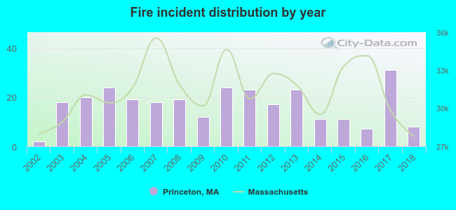 Based on the data from the years 2002 - 2018 the average number of fire incidents per year is 17. The highest number of fire incidents - 31 took place in 2017, and the least - 2 in 2002. The data has an increasing trend.
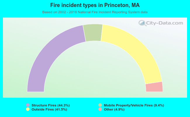 When looking into fire subcategories, the most reports belonged to: Structure Fires (44.3%), and Outside Fires (41.5%).
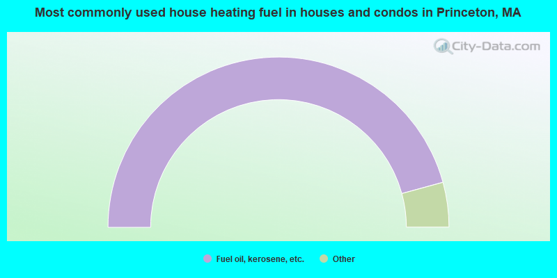
- 91.5%Fuel oil, kerosene, etc.
- 3.8%Wood
- 2.9%Electricity
- 1.2%Bottled, tank, or LP gas
- 0.4%Other fuel
- 0.3%Utility gas
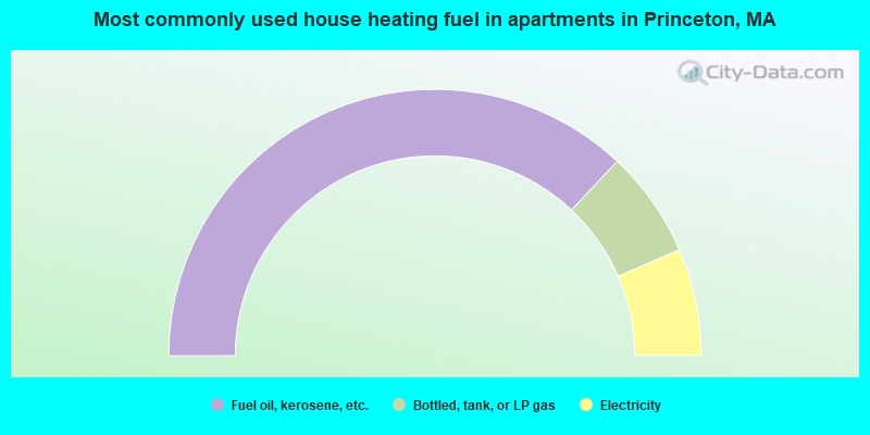
- 74.0%Fuel oil, kerosene, etc.
- 13.0%Bottled, tank, or LP gas
- 13.0%Electricity
Princeton compared to Massachusetts state average:
- Median household income above state average.
- Unemployed percentage significantly below state average.
- Black race population percentage significantly below state average.
- Hispanic race population percentage significantly below state average.
- Median age above state average.
- Foreign-born population percentage significantly below state average.
- Renting percentage significantly below state average.
- Length of stay since moving in significantly above state average.
- Number of rooms per house significantly below state average.
- House age significantly below state average.
- Percentage of population with a bachelor's degree or higher above state average.

|
|
Total of 172 patent applications in 2008-2024.