Rutland, Massachusetts
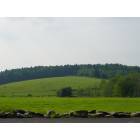
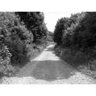
Rutland: Field on Glenwood Road
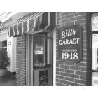
Rutland: Bill's Garage of Rutland
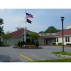
Rutland: Rutland Public Library
Rutland
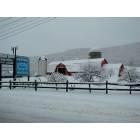
Rutland: June 2007 - Rutland Prison Camps
- add
your
Submit your own pictures of this place and show them to the world
- OSM Map
- General Map
- Google Map
- MSN Map
Population change since 2000: -4.3%
| Males: 1,077 | |
| Females: 1,034 |
| Median resident age: | 47.8 years |
| Massachusetts median age: | 40.3 years |
Zip codes: 01543.
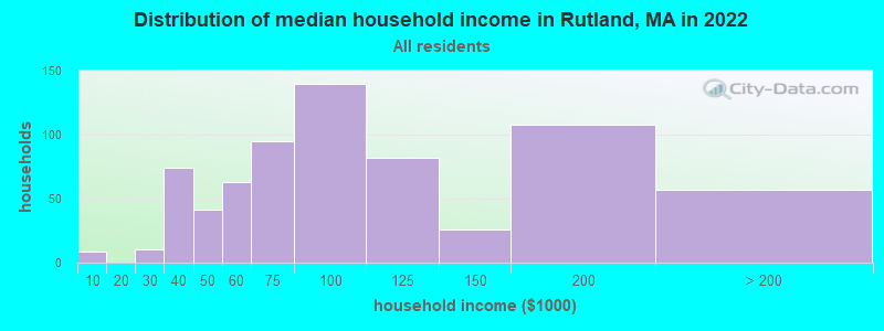
| Rutland: | $81,911 |
| MA: | $94,488 |
Estimated per capita income in 2022: $41,394 (it was $21,792 in 2000)
Rutland CDP income, earnings, and wages data
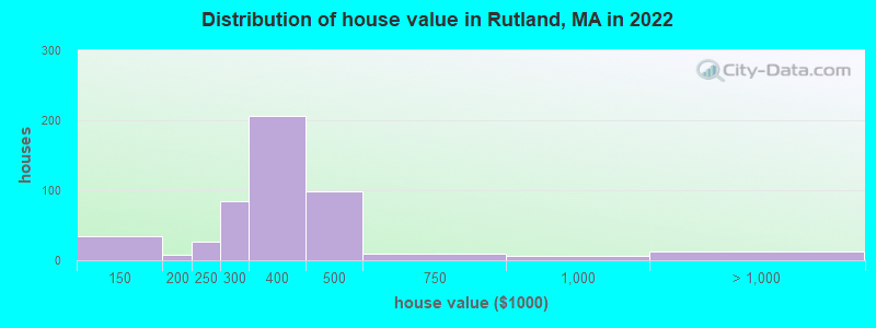
Estimated median house or condo value in 2022: $352,273 (it was $132,100 in 2000)
| Rutland: | $352,273 |
| MA: | $534,700 |
Mean prices in 2022: all housing units: $419,164; detached houses: $447,621; townhouses or other attached units: $343,592; in 2-unit structures: $323,295; in 3-to-4-unit structures: $332,295; in 5-or-more-unit structures: $232,758; mobile homes: $113,885
Median gross rent in 2022: $1,162.
Detailed information about poverty and poor residents in Rutland, MA


Compare current foreclosures near Rutland, MA:
| Photo | Address | Area | Beds / Baths | Price | Details |
|---|---|---|---|---|---|

|
#1
Britney Dr
Rutland, MA 01543
|
1,672 sq. feet
|
1 baths 3 beds |
show details | |

|
#2
Oakridge Dr
Rutland, MA 01543
|
1,190 sq. feet
|
1 baths 3 beds |
show details | |

|
#3
Winifreds Way
Rutland, MA 01543
|
1,736 sq. feet
|
2 baths 3 beds |
show details | |

|
#4
Irish Ln
Rutland, MA 01543
|
1,680 sq. feet
|
2 baths 3 beds |
show details | |

|
#5
Jackson Ave
Rutland, MA 01543
|
2,344 sq. feet
|
2 baths 4 beds |
show details | |

|
#6
Pommogussett Rd
Rutland, MA 01543
|
2,904 sq. feet
|
3 baths 4 beds |
show details | |

|
#7
Colonial Dr
Rutland, MA 01543
|
1,772 sq. feet
|
2 baths 3 beds |
show details | |

|
#8
Grizzly Dr
Rutland, MA 01543
|
- sq. feet
|
- baths - beds |
show details | |

|
#9
Helen Ave
Rutland, MA 01543
|
- sq. feet
|
- baths - beds |
show details | |

|
#10
Oakridge Dr
Rutland, MA 01543
|
- sq. feet
|
- baths - beds |
show details |
| Photo | Address | Area | Beds / Baths | Price | Details |
|---|---|---|---|---|---|

|
#11
Sylvan Ave
Leominster, MA 01453
|
720 sq. feet
|
1 baths 2 beds |
$375,000
|
show details |

|
#12
Graham St
Leominster, MA 01453
|
1,036 sq. feet
|
1 baths 3 beds |
$485,000
|
show details |

|
#13
Nome St
Worcester, MA 01605
|
960 sq. feet
|
1 baths 4 beds |
$208,000
|
show details |

|
#14
Parker St
Gardner, MA 01440
|
1,980 sq. feet
|
2 baths 4 beds |
$469,900
|
show details |

|
#15
N Brookfield Rd
Oakham, MA 01068
|
1,078 sq. feet
|
1 baths 2 beds |
$439,900
|
show details |

|
#16
Maple Ave
Rutland, MA 01543
|
- sq. feet
|
- baths - beds |
show details | |

|
#17
Irish Ln
Rutland, MA 01543
|
- sq. feet
|
- baths - beds |
show details | |

|
#18
Irish Ln
Rutland, MA 01543
|
- sq. feet
|
- baths - beds |
show details | |

|
#19
Hardwick Road
Hardwick, MA 01037
|
- sq. feet
|
1 baths 3 beds |
$244,900
|
show details |

|
#20
Old West Brookfield Road
Warren, MA 01083
|
1,760 sq. feet
|
2 baths 4 beds |
show details |
| Photo | Address | Area | Beds / Baths | Price | Details |
|---|---|---|---|---|---|

|
#21
W Main St
Ware, MA 01082
|
3,645 sq. feet
|
3 baths 5 beds |
show details | |

|
#22
Grove Ave
Leominster, MA 01453
|
3,097 sq. feet
|
1 baths 4 beds |
show details | |

|
#23
Hawkins St
Worcester, MA 01604
|
864 sq. feet
|
1 baths 3 beds |
show details | |

|
#24
Leicester St
Auburn, MA 01501
|
912 sq. feet
|
1 baths 2 beds |
show details | |

|
#25
East Road
Warren, MA 01083
|
1,938 sq. feet
|
2 baths 3 beds |
show details | |

|
#26
Beacon St
Worcester, MA 01610
|
2,869 sq. feet
|
3 baths 8 beds |
show details | |

|
#27
Nelson Street
Warren, MA 01083
|
- sq. feet
|
2 baths 3 beds |
show details | |

|
#28
Treadwell Ter
Spencer, MA 01562
|
960 sq. feet
|
1 baths 3 beds |
show details | |

|
#29
Riverlin St
Millbury, MA 01527
|
1,162 sq. feet
|
2 baths 2 beds |
show details | |

|
#30
Pocasset Ave
Worcester, MA 01606
|
2,090 sq. feet
|
3 baths 3 beds |
show details |
| Photo | Address | Area | Beds / Baths | Price | Details |
|---|---|---|---|---|---|

|
#31
Mallard Drive, Unit 59 Coggshall Crossing Condominium
Fitchburg, MA 01420
|
1,306 sq. feet
|
1 baths 2 beds |
show details | |

|
#32
Federal Hill Rd
Auburn, MA 01501
|
702 sq. feet
|
1 baths 2 beds |
show details | |

|
#33
Grafton St
Shrewsbury, MA 01545
|
3,951 sq. feet
|
2 baths 4 beds |
show details | |

|
#34
Partridgeville Rd
Templeton, MA 01468
|
1,523 sq. feet
|
1 baths 3 beds |
show details | |

|
#35
Summer St
Gardner, MA 01440
|
1,893 sq. feet
|
2 baths 5 beds |
show details | |

|
#36
Grove St
Shrewsbury, MA 01545
|
2,120 sq. feet
|
2 baths 3 beds |
show details | |

|
#37
Pleasant St
Leominster, MA 01453
|
1,447 sq. feet
|
1 baths 3 beds |
show details | |

|
#38
Dogwood Rd
Leominster, MA 01453
|
1,428 sq. feet
|
1 baths 3 beds |
show details | |

|
#39
Paul St
Auburn, MA 01501
|
1,037 sq. feet
|
1 baths 3 beds |
show details | |

|
#40
Ideal Rd
Worcester, MA 01604
|
1,334 sq. feet
|
1 baths 3 beds |
show details |
| Photo | Address | Area | Beds / Baths | Price | Details |
|---|---|---|---|---|---|

|
#41
Appleton Rd
Auburn, MA 01501
|
1,590 sq. feet
|
2 baths 4 beds |
show details | |

|
#42
Beach Dr
West Brookfield, MA 01585
|
744 sq. feet
|
1 baths 1 beds |
show details | |

|
#43
Old Meetinghouse Rd
Auburn, MA 01501
|
702 sq. feet
|
1 baths 2 beds |
show details | |

|
#44
Francis Ave
Shrewsbury, MA 01545
|
1,849 sq. feet
|
1 baths 3 beds |
show details | |

|
#45
Emerald St
Gardner, MA 01440
|
1,428 sq. feet
|
1 baths 2 beds |
show details | |

|
#46
Hadley Path
West Brookfield, MA 01585
|
1,320 sq. feet
|
1 baths 3 beds |
show details | |

|
#47
Marion Ave
Millbury, MA 01527
|
852 sq. feet
|
1 baths 2 beds |
show details | |

|
#48
Pine St
Gardner, MA 01440
|
3,228 sq. feet
|
2 baths 4 beds |
show details | |

|
#49
Pine St
Gardner, MA 01440
|
3,228 sq. feet
|
2 baths 4 beds |
show details | |

|
Check over 1 million property listings on Foreclosure.com!
|
browse all offers | |||


- 1,55991.9%White alone
- 955.6%Hispanic
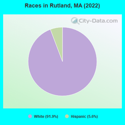
Races in Rutland detailed stats: ancestries, foreign born residents, place of birth
According to our research of Massachusetts and other state lists, there were 5 registered sex offenders living in Rutland, Massachusetts as of May 20, 2024.
The ratio of all residents to sex offenders in Rutland is 493 to 1.
Type |
2009 |
2010 |
2011 |
2012 |
2013 |
2014 |
2015 |
2016 |
2017 |
2018 |
2019 |
2020 |
2021 |
2022 |
|---|---|---|---|---|---|---|---|---|---|---|---|---|---|---|
| Murders (per 100,000) | 0 (0.0) | 0 (0.0) | 1 (12.5) | 0 (0.0) | 1 (12.1) | 1 (12.0) | 0 (0.0) | 0 (0.0) | 0 (0.0) | 0 (0.0) | 0 (0.0) | 0 (0.0) | 0 (0.0) | 0 (0.0) |
| Rapes (per 100,000) | 4 (49.3) | 2 (25.1) | 3 (37.4) | 6 (74.3) | 3 (36.3) | 3 (35.9) | 3 (35.5) | 2 (23.3) | 3 (34.5) | 1 (11.4) | 10 (112.5) | 3 (33.3) | 7 (76.0) | 5 (53.7) |
| Robberies (per 100,000) | 1 (12.3) | 0 (0.0) | 0 (0.0) | 0 (0.0) | 1 (12.1) | 0 (0.0) | 0 (0.0) | 0 (0.0) | 0 (0.0) | 0 (0.0) | 1 (11.3) | 1 (11.1) | 0 (0.0) | 1 (10.7) |
| Assaults (per 100,000) | 9 (111.0) | 19 (238.3) | 15 (187.0) | 13 (161.0) | 20 (241.8) | 11 (131.8) | 22 (260.6) | 15 (174.4) | 15 (172.7) | 17 (193.1) | 24 (270.0) | 26 (288.9) | 21 (228.1) | 28 (300.6) |
| Burglaries (per 100,000) | 27 (333.0) | 22 (275.9) | 48 (598.4) | 31 (384.0) | 11 (133.0) | 10 (119.8) | 31 (367.2) | 14 (162.8) | 19 (218.7) | 4 (45.4) | 5 (56.3) | 2 (22.2) | 9 (97.7) | 10 (107.3) |
| Thefts (per 100,000) | 23 (283.6) | 26 (326.1) | 48 (598.4) | 28 (346.8) | 37 (447.3) | 28 (335.5) | 48 (568.5) | 44 (511.7) | 47 (541.0) | 21 (238.6) | 15 (168.8) | 10 (111.1) | 9 (97.7) | 11 (118.1) |
| Auto thefts (per 100,000) | 5 (61.7) | 4 (50.2) | 3 (37.4) | 2 (24.8) | 4 (48.4) | 4 (47.9) | 2 (23.7) | 4 (46.5) | 4 (46.0) | 2 (22.7) | 2 (22.5) | 2 (22.2) | 3 (32.6) | 1 (10.7) |
| Arson (per 100,000) | 1 (12.3) | 0 (0.0) | 3 (37.4) | 0 (0.0) | 0 (0.0) | 1 (12.0) | 1 (11.8) | 0 (0.0) | 1 (11.5) | 0 (0.0) | 0 (0.0) | 0 (0.0) | 0 (0.0) | 0 (0.0) |
| City-Data.com crime index | 104.9 | 104.1 | 161.1 | 134.4 | 136.2 | 104.7 | 130.9 | 89.1 | 102.8 | 62.3 | 159.9 | 95.6 | 119.8 | 119.4 |
The City-Data.com crime index weighs serious crimes and violent crimes more heavily. Higher means more crime, U.S. average is 246.1. It adjusts for the number of visitors and daily workers commuting into cities.
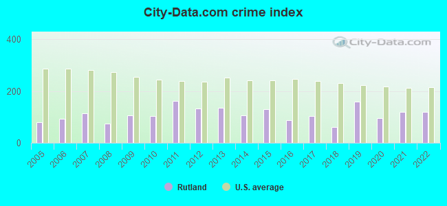
Crime rate in Rutland detailed stats: murders, rapes, robberies, assaults, burglaries, thefts, arson
Full-time law enforcement employees in 2015, including police officers: 11 (10 officers - 9 male; 1 female).
| Officers per 1,000 residents here: | 1.18 |
| Massachusetts average: | 2.54 |
 Recent articles from our blog. Our writers, many of them Ph.D. graduates or candidates, create easy-to-read articles on a wide variety of topics.

 | Boston crime thread - all posts go here. (2497 replies) |
| Restaurants Businesses Closing (182 replies) |
| Boston (the city) Has Lost Its Allure for Me (141 replies) |
| Central or Western MA towns for Seniors (16 replies) |
| Coronavirus in Massachusetts (18048 replies) |
| Moving Small Family to Worcester. Advice? (25 replies) |
Latest news from Rutland, MA collected exclusively by city-data.com from local newspapers, TV, and radio stations
Ancestries: American (39.5%), Irish (23.2%), Finnish (6.1%), French Canadian (5.6%), Italian (5.6%), Scotch-Irish (4.9%).
Current Local Time: EST time zone
Incorporated in 1713
Elevation: 1112 feet
Land area: 2.96 square miles.
Population density: 714 people per square mile (low).
9 residents are foreign born
| This place: | 0.5% |
| Massachusetts: | 17.6% |
Median real estate property taxes paid for housing units with mortgages in 2022: $4,478 (1.3%)
Median real estate property taxes paid for housing units with no mortgage in 2022: $4,351 (1.2%)
Nearest city with pop. 50,000+: Worcester, MA  (10.1 miles , pop. 172,648).
Nearest city with pop. 200,000+: Boston, MA (44.2 miles , pop. 589,141).
Nearest city with pop. 1,000,000+: Bronx, NY (144.6 miles , pop. 1,332,650).
Nearest cities:
Latitude: 42.37 N, Longitude: 71.95 W
Area codes: 774, 508
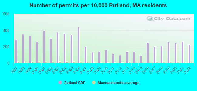
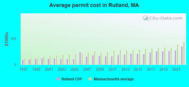
Single-family new house construction building permits:
- 2022: 50 buildings, average cost: $353,300
- 2021: 58 buildings, average cost: $278,000
- 2020: 54 buildings, average cost: $266,800
- 2019: 56 buildings, average cost: $258,800
- 2018: 46 buildings, average cost: $260,600
- 2017: 44 buildings, average cost: $240,400
- 2016: 55 buildings, average cost: $201,600
- 2015: 21 buildings, average cost: $215,800
- 2014: 31 buildings, average cost: $214,900
- 2013: 32 buildings, average cost: $193,600
- 2012: 22 buildings, average cost: $191,600
- 2011: 25 buildings, average cost: $164,700
- 2010: 36 buildings, average cost: $164,400
- 2009: 32 buildings, average cost: $172,000
- 2008: 29 buildings, average cost: $183,200
- 2007: 44 buildings, average cost: $162,600
- 2006: 97 buildings, average cost: $244,100
- 2005: 77 buildings, average cost: $117,200
- 2004: 80 buildings, average cost: $117,600
- 2003: 83 buildings, average cost: $116,000
- 2002: 67 buildings, average cost: $125,100
- 2001: 88 buildings, average cost: $114,400
- 2000: 58 buildings, average cost: $128,300
- 1999: 73 buildings, average cost: $117,600
- 1998: 78 buildings, average cost: $102,700
- 1997: 64 buildings, average cost: $99,700
| Here: | 3.6% |
| Massachusetts: | 3.5% |
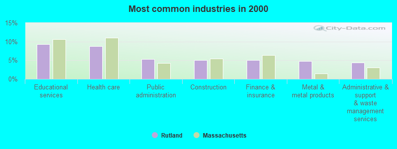
- Educational services (9.3%)
- Health care (8.8%)
- Public administration (5.4%)
- Construction (5.0%)
- Finance & insurance (5.0%)
- Metal & metal products (4.8%)
- Administrative & support & waste management services (4.4%)
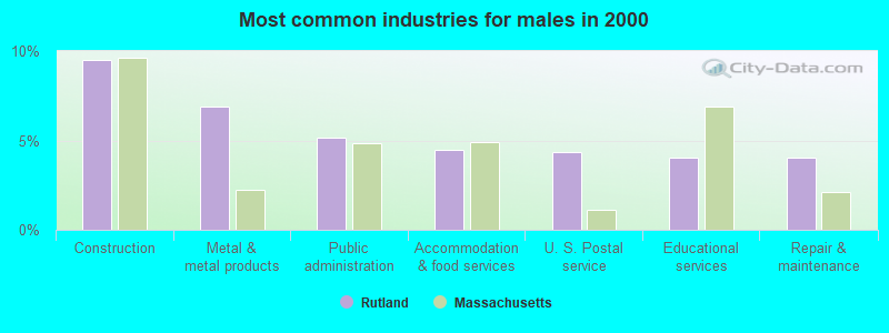
- Construction (9.5%)
- Metal & metal products (6.9%)
- Public administration (5.1%)
- Accommodation & food services (4.5%)
- U. S. Postal service (4.3%)
- Educational services (4.0%)
- Repair & maintenance (4.0%)
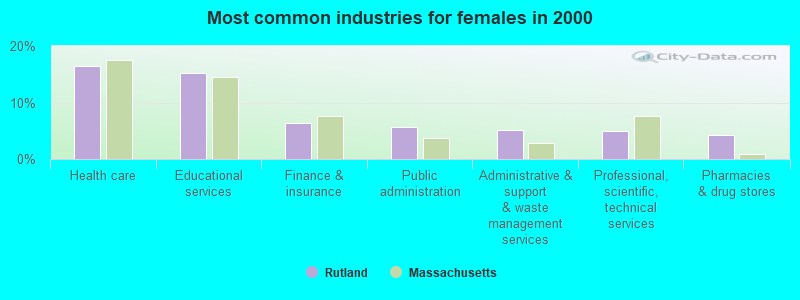
- Health care (16.4%)
- Educational services (15.2%)
- Finance & insurance (6.3%)
- Public administration (5.6%)
- Administrative & support & waste management services (5.1%)
- Professional, scientific, technical services (4.9%)
- Pharmacies & drug stores (4.3%)
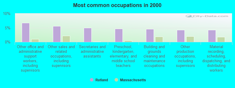
- Other office and administrative support workers, including supervisors (6.7%)
- Other sales and related occupations, including supervisors (5.5%)
- Secretaries and administrative assistants (4.9%)
- Preschool, kindergarten, elementary, and middle school teachers (4.6%)
- Building and grounds cleaning and maintenance occupations (4.5%)
- Other production occupations, including supervisors (4.3%)
- Material recording, scheduling, dispatching, and distributing workers (4.3%)
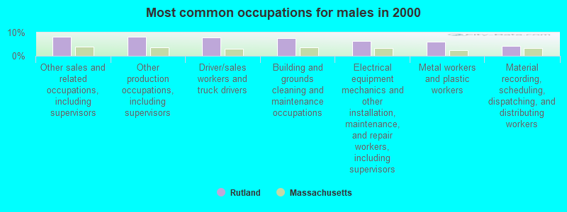
- Other sales and related occupations, including supervisors (8.2%)
- Other production occupations, including supervisors (8.0%)
- Driver/sales workers and truck drivers (7.9%)
- Building and grounds cleaning and maintenance occupations (7.6%)
- Electrical equipment mechanics and other installation, maintenance, and repair workers, including supervisors (6.3%)
- Metal workers and plastic workers (6.1%)
- Material recording, scheduling, dispatching, and distributing workers (4.3%)
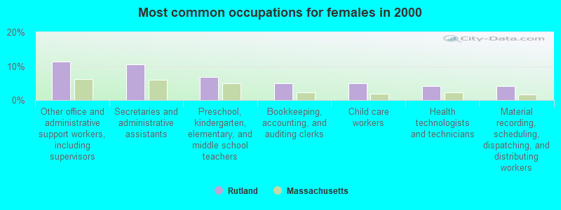
- Other office and administrative support workers, including supervisors (11.4%)
- Secretaries and administrative assistants (10.5%)
- Preschool, kindergarten, elementary, and middle school teachers (6.9%)
- Bookkeeping, accounting, and auditing clerks (4.9%)
- Child care workers (4.9%)
- Health technologists and technicians (4.2%)
- Material recording, scheduling, dispatching, and distributing workers (4.2%)
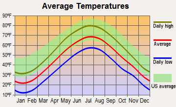
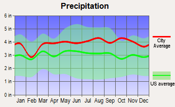
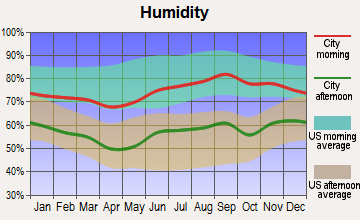
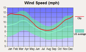
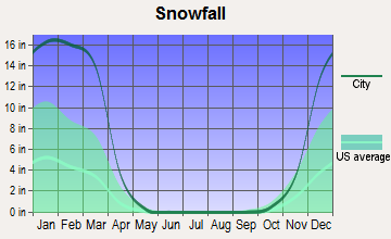
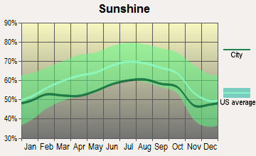
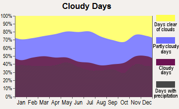
Average climate in Rutland, Massachusetts
Based on data reported by over 4,000 weather stations
(lower is better)
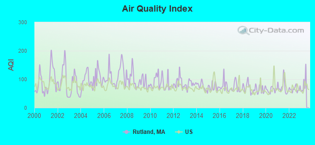
Air Quality Index (AQI) level in 2022 was 65.7. This is about average.
| City: | 65.7 |
| U.S.: | 72.6 |
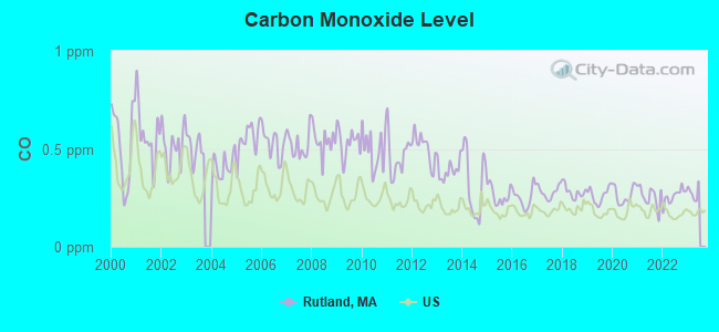
Carbon Monoxide (CO) [ppm] level in 2022 was 0.259. This is about average. Closest monitor was 10.4 miles away from the city center.
| City: | 0.259 |
| U.S.: | 0.251 |
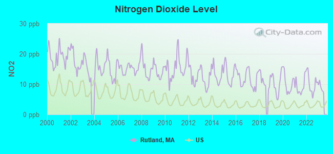
Nitrogen Dioxide (NO2) [ppb] level in 2022 was 10.1. This is significantly worse than average. Closest monitor was 10.3 miles away from the city center.
| City: | 10.1 |
| U.S.: | 5.1 |
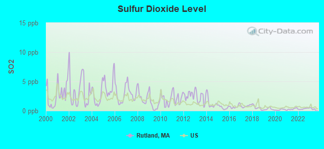
Sulfur Dioxide (SO2) [ppb] level in 2022 was 0.337. This is significantly better than average. Closest monitor was 10.3 miles away from the city center.
| City: | 0.337 |
| U.S.: | 1.515 |
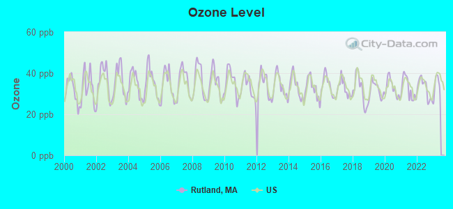
Ozone [ppb] level in 2022 was 32.5. This is about average. Closest monitor was 3.7 miles away from the city center.
| City: | 32.5 |
| U.S.: | 33.3 |
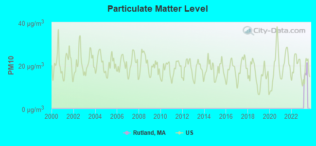
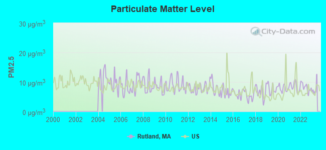
Particulate Matter (PM2.5) [µg/m3] level in 2022 was 8.22. This is about average. Closest monitor was 10.7 miles away from the city center.
| City: | 8.22 |
| U.S.: | 8.11 |
Tornado activity:
Rutland-area historical tornado activity is slightly above Massachusetts state average. It is 15% smaller than the overall U.S. average.
On 6/9/1953, a category F4 (max. wind speeds 207-260 mph) tornado 13.3 miles away from the Rutland place center killed 90 people and injured 1228 people and caused between $50,000,000 and $500,000,000 in damages.
On 6/22/1981, a category F3 (max. wind speeds 158-206 mph) tornado 10.1 miles away from the place center injured 3 people and caused between $5000 and $50,000 in damages.
Earthquake activity:
Rutland-area historical earthquake activity is significantly above Massachusetts state average. It is 71% smaller than the overall U.S. average.On 10/7/1983 at 10:18:46, a magnitude 5.3 (5.1 MB, 5.3 LG, 5.1 ML, Class: Moderate, Intensity: VI - VII) earthquake occurred 163.1 miles away from Rutland center
On 4/20/2002 at 10:50:47, a magnitude 5.3 (5.3 ML, Depth: 3.0 mi) earthquake occurred 172.4 miles away from the city center
On 4/20/2002 at 10:50:47, a magnitude 5.2 (5.2 MB, 4.2 MS, 5.2 MW, 5.0 MW) earthquake occurred 171.5 miles away from the city center
On 1/19/1982 at 00:14:42, a magnitude 4.7 (4.5 MB, 4.7 MD, 4.5 LG, Class: Light, Intensity: IV - V) earthquake occurred 80.5 miles away from Rutland center
On 10/16/2012 at 23:12:25, a magnitude 4.7 (4.7 ML, Depth: 10.0 mi) earthquake occurred 107.5 miles away from the city center
On 10/2/1994 at 11:27:22, a magnitude 3.7 (3.5 LG, 3.7 LG, Depth: 6.2 mi, Class: Light, Intensity: II - III) earthquake occurred 16.7 miles away from Rutland center
Magnitude types: regional Lg-wave magnitude (LG), body-wave magnitude (MB), duration magnitude (MD), local magnitude (ML), surface-wave magnitude (MS), moment magnitude (MW)
Natural disasters:
The number of natural disasters in Worcester County (27) is a lot greater than the US average (15).Major Disasters (Presidential) Declared: 15
Emergencies Declared: 12
Causes of natural disasters: Floods: 9, Storms: 8, Hurricanes: 6, Snowstorms: 5, Winter Storms: 4, Blizzards: 2, Snows: 2, Fire: 1, Heavy Rain: 1, Snowfall: 1, Tornado: 1, Wind: 1 (Note: some incidents may be assigned to more than one category).
Hospitals and medical centers in Rutland:
Other hospitals and medical centers near Rutland:
- MEDICAL CTR OF CENTRAL MASS-HOLDEN (Hospital, about 5 miles away; HOLDEN, MA)
- WACHUSETT EXTENDED CARE FACILITY (Nursing Home, about 5 miles away; HOLDEN, MA)
- HOLDEN NURSING HOME (Nursing Home, about 6 miles away; HOLDEN, MA)
- HOLDEN REHABILITATION AND SKILLED NURSING CENTER INC (Nursing Home, about 6 miles away; HOLDEN, MA)
- OUR LADY OF MERCY HEALTH CARE (Nursing Home, about 8 miles away; WORCESTER, MA)
- JEWISH HOME HOSPICE (Hospital, about 8 miles away; WORCESTER, MA)
- JEWISH HEALTHCARE CENTER (Nursing Home, about 8 miles away; WORCESTER, MA)
Amtrak station near Rutland:
Colleges/universities with over 2000 students nearest to Rutland:
- Assumption College (about 8 miles; Worcester, MA; Full-time enrollment: 2,580)
- Worcester State University (about 9 miles; Worcester, MA; FT enrollment: 5,426)
- Quinsigamond Community College (about 9 miles; Worcester, MA; FT enrollment: 5,877)
- Worcester Polytechnic Institute (about 10 miles; Worcester, MA; FT enrollment: 3,930)
- Clark University (about 11 miles; Worcester, MA; FT enrollment: 3,687)
- College of the Holy Cross (about 12 miles; Worcester, MA; FT enrollment: 3,125)
- Mount Wachusett Community College (about 16 miles; Gardner, MA; FT enrollment: 3,143)
Private high school in Rutland:
Public elementary/middle schools in Rutland:
- CENTRAL TREE MIDDLE (Students: 346, Location: 281 MAIN STREET, Grades: 6-8)
- NAQUAG ELEMENTARY SCHOOL (Students: 338, Location: 285 MAIN STREET, Grades: KG-2)
- GLENWOOD ELEMENTARY SCHOOL (Location: 65 GLENWOOD ROAD, Grades: 3-5)
Points of interest:
Notable location: Rutland Free Public Library (A). Display/hide its location on the map
Churches in Rutland include: Saint Patricks Church (A), First Congregational Church (B). Display/hide their locations on the map
Reservoir: Demond Pond (A). Display/hide its location on the map
Drinking water stations with addresses in Rutland and their reported violations in the past:
RUTLAND WATER DEPARTMENT (Population served: 5,049, Surface water):Past health violations:COOL SANDY BEACH COMMUNITY WATER SYSTEM (Population served: 70, Groundwater):Past monitoring violations:
- MCL, Monthly (TCR) - In OCT-2013, Contaminant: Coliform. Follow-up actions: St AO (w/o penalty) issued (DEC-13-2013), St Compliance achieved (DEC-13-2013)
- Monitoring and Reporting (DBP) - Between OCT-2013 and DEC-2013, Contaminant: TTHM. Follow-up actions: St AO (w/o penalty) issued (MAR-03-2014), St Compliance achieved (MAR-03-2014)
- Monitoring and Reporting (DBP) - Between JUL-2013 and SEP-2013, Contaminant: Total Haloacetic Acids (HAA5). Follow-up actions: St AO (w/o penalty) issued (MAR-03-2014), St Compliance achieved (MAR-03-2014)
- One minor monitoring violation
- One regular monitoring violation
Past health violations:
- MCL, Monthly (TCR) - In AUG-2013, Contaminant: Coliform. Follow-up actions: St AO (w/o penalty) issued (OCT-22-2013)
- MCL, Monthly (TCR) - In AUG-2012, Contaminant: Coliform. Follow-up actions: St AO (w/o penalty) issued (SEP-28-2012), St Compliance achieved (SEP-28-2012)
- MCL, Monthly (TCR) - In JUN-2011, Contaminant: Coliform. Follow-up actions: St AO (w/o penalty) issued (AUG-24-2011)
- MCL, Monthly (TCR) - In OCT-2010, Contaminant: Coliform. Follow-up actions: St AO (w/o penalty) issued (NOV-16-2010), St Compliance achieved (DEC-23-2010)
- MCL, Monthly (TCR) - In AUG-2010, Contaminant: Coliform. Follow-up actions: St AO (w/o penalty) issued (NOV-16-2010), St Compliance achieved (DEC-23-2010)
- MCL, Monthly (TCR) - In JUL-2010, Contaminant: Coliform. Follow-up actions: St AO (w/o penalty) issued (NOV-16-2010), St Compliance achieved (DEC-23-2010)
- 4 other older health violations
| This place: | 2.6 people |
| Massachusetts: | 2.5 people |
| This place: | 72.3% |
| Whole state: | 63.0% |
| This place: | 6.7% |
| Whole state: | 7.0% |
Likely homosexual households (counted as self-reported same-sex unmarried-partner households)
- Lesbian couples: 1.1% of all households
- Gay men: 0.4% of all households
7 people in group homes intended for adults in 2010
105 people in homes for the mentally ill in 2000
8 people in homes for the mentally retarded in 2000
Banks with branches in Rutland (2011 data):
- Spencer Savings Bank: Rutland Branch at 93 Main St., branch established on 1985/02/19. Info updated 2008/03/03: Bank assets: $375.2 mil, Deposits: $295.7 mil, headquarters in Spencer, MA, positive income, Mortgage Lending Specialization, 5 total offices, Holding Company: Spencer Mhc
For population 15 years and over in Rutland:
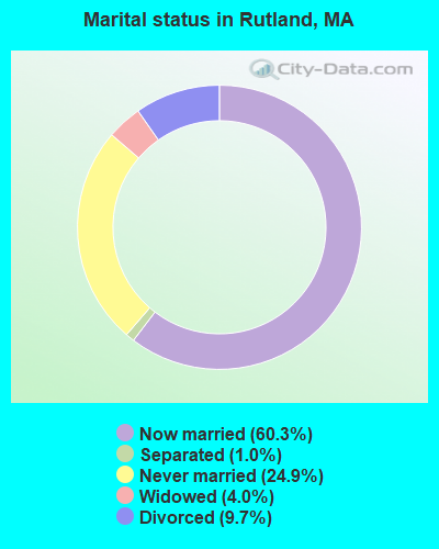
- Never married: 24.9%
- Now married: 60.3%
- Separated: 1.0%
- Widowed: 4.0%
- Divorced: 9.7%
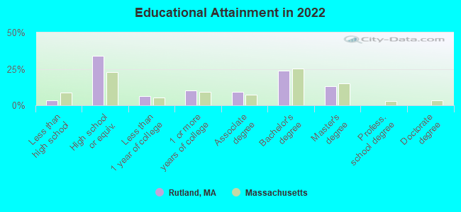
For population 25 years and over in Rutland:
- High school or higher: 97.3%
- Bachelor's degree or higher: 37.7%
- Graduate or professional degree: 13.6%
- Unemployed: 4.0%
- Mean travel time to work (commute): 36.3 minutes
| Here: | 9.0 |
| Massachusetts average: | 13.0 |


Graphs represent county-level data. Detailed 2008 Election Results
Religion statistics for Rutland, MA (based on Worcester County data)


| Religion | Adherents | Congregations |
|---|---|---|
| Catholic | 306,925 | 118 |
| Mainline Protestant | 43,326 | 171 |
| Evangelical Protestant | 37,511 | 203 |
| Other | 18,931 | 69 |
| Orthodox | 7,935 | 15 |
| Black Protestant | 497 | 6 |
| None | 383,427 | - |
Food Environment Statistics:
| Worcester County: | 1.73 / 10,000 pop. |
| Massachusetts: | 1.98 / 10,000 pop. |
| Worcester County: | 0.05 / 10,000 pop. |
| Massachusetts: | 0.05 / 10,000 pop. |
| Worcester County: | 1.79 / 10,000 pop. |
| Massachusetts: | 2.22 / 10,000 pop. |
| Worcester County: | 2.22 / 10,000 pop. |
| State: | 1.77 / 10,000 pop. |
| Worcester County: | 7.27 / 10,000 pop. |
| State: | 8.76 / 10,000 pop. |
| Worcester County: | 8.0% |
| Massachusetts: | 8.1% |
| Worcester County: | 24.0% |
| Massachusetts: | 22.5% |
| This county: | 16.6% |
| State: | 16.5% |
Health and Nutrition:
| This city: | 52.2% |
| Massachusetts: | 50.5% |
| Rutland: | 48.7% |
| State: | 48.0% |
| This city: | 27.6 |
| Massachusetts: | 28.4 |
| Rutland: | 16.6% |
| Massachusetts: | 20.7% |
| Rutland: | 6.8 |
| Massachusetts: | 6.8 |
| Rutland: | 28.8% |
| Massachusetts: | 33.4% |
| This city: | 58.6% |
| Massachusetts: | 57.1% |
| Rutland: | 77.1% |
| Massachusetts: | 79.2% |
More about Health and Nutrition of Rutland, MA Residents
4.71% of this county's 2021 resident taxpayers lived in other counties in 2020 ($76,229 average adjusted gross income)
| Here: | 4.71% |
| Massachusetts average: | 6.35% |
0.02% of residents moved from foreign countries ($100 average AGI)
Worcester County: 0.02% Massachusetts average: 0.01%
Top counties from which taxpayers relocated into this county between 2020 and 2021:
| from Middlesex County, MA | |
| from Norfolk County, MA | |
| from Suffolk County, MA |
4.84% of this county's 2020 resident taxpayers moved to other counties in 2021 ($87,252 average adjusted gross income)
| Here: | 4.84% |
| Massachusetts average: | 7.18% |
0.03% of residents moved to foreign countries ($199 average AGI)
Worcester County: 0.03% Massachusetts average: 0.02%
Top counties to which taxpayers relocated from this county between 2020 and 2021:
| to Middlesex County, MA | |
| to Norfolk County, MA | |
| to Suffolk County, MA |
| Businesses in Rutland, MA | ||||
| Name | Count | Name | Count | |
|---|---|---|---|---|
| Decora Cabinetry | 3 | MasterBrand Cabinets | 7 | |
| Dunkin Donuts | 2 | UPS | 1 | |
Strongest AM radio stations in Rutland:
- WCRN (830 AM; 50 kW; WORCESTER, MA; Owner: CARTER BROADCASTING CORPORATION)
- WVNE (760 AM; daytime; 25 kW; LEICESTER, MA; Owner: BLOUNT MASSCOM, INC.)
- WTAG (580 AM; 5 kW; WORCESTER, MA; Owner: CAPSTAR TX LIMITED PARTNERSHIP)
- WVEI (1440 AM; 5 kW; WORCESTER, MA; Owner: ENTERCOM BOSTON LICENSE, LLC)
- WKOX (1200 AM; 50 kW; FRAMINGHAM, MA; Owner: CAPSTAR TX LIMITED PARTNERSHIP)
- WBIX (1060 AM; 40 kW; NATICK, MA; Owner: LANGER BROADCASTING CORPORATION)
- WRKO (680 AM; 50 kW; BOSTON, MA; Owner: ENTERCOM BOSTON LICENSE, LLC)
- WEEI (850 AM; 50 kW; BOSTON, MA; Owner: ENTERCOM BOSTON LICENSE, LLC)
- WALE (990 AM; 50 kW; GREENVILLE, RI; Owner: NORTH AMERICAN BROADCASTING CO., INC.)
- WNNZ (640 AM; 50 kW; WESTFIELD, MA; Owner: CLEAR CHANNEL BROADCASTING LICENSES, INC.)
- WAMG (890 AM; 25 kW; DEDHAM, MA; Owner: MEGA COMMUNICATIONS OF DEDHAM LICENSEE, LLC)
- WORC (1310 AM; 5 kW; WORCESTER, MA; Owner: CHOWDER BROADCAST GROUP LLC)
- WWZN (1510 AM; 50 kW; BOSTON, MA; Owner: ROSE CITY RADIO CORPORATION)
Strongest FM radio stations in Rutland:
- WAAF (107.3 FM; WORCESTER, MA; Owner: ENTERCOM BOSTON LICENSE, LLC)
- WSRS (96.1 FM; WORCESTER, MA; Owner: CAPSTAR TX LIMITED PARTNERSHIP)
- WXLO (104.5 FM; FITCHBURG, MA; Owner: CITADEL BROADCASTING COMPANY)
- WBPR (91.9 FM; WORCESTER, MA; Owner: UNIVERSITY OF MASSACHUSETTS)
- WFCR (88.5 FM; AMHERST, MA; Owner: UNIVERSITY OF MASSACHUSETTS)
- WICN (90.5 FM; WORCESTER, MA; Owner: WICN PUBLIC RADIO, INC)
- WFEX (92.1 FM; PETERBOROUGH, NH; Owner: FNX BROADCASTING OF NEW HAMPSHIRE LLC)
- WAMH (89.3 FM; AMHERST, MA; Owner: TRUSTEES OF AMHERST COLLEGE)
- WAHL (99.9 FM; ATHOL, MA; Owner: CITADEL BROADCASTING COMPANY)
- WYCM (90.1 FM; CHARLTON, MA; Owner: BAY PATH VOCATIONAL HIGH SCHOOL)
- WBMX (98.5 FM; BOSTON, MA; Owner: INFINITY RADIO OPERATIONS INC.)
- WJMN (94.5 FM; BOSTON, MA; Owner: AMFM RADIO LICENSES, L.L.C.)
- WCRB (102.5 FM; WALTHAM, MA; Owner: CHARLES RIVER BROADCASTING WCRB LICE)
- WTKK (96.9 FM; BOSTON, MA; Owner: GREATER BOSTON RADIO, INC.)
- WROR-FM (105.7 FM; FRAMINGHAM, MA; Owner: GREATER BOSTON RADIO, INC.)
- WBOS (92.9 FM; BROOKLINE, MA; Owner: GREATER BOSTON RADIO, INC.)
- WGBH (89.7 FM; BOSTON, MA; Owner: WGBH EDUCATIONAL FOUNDATION)
- WHYN-FM (93.1 FM; SPRINGFIELD, MA; Owner: CLEAR CHANNEL BROADCASTING LICENSES, INC.)
- WBUR-FM (90.9 FM; BOSTON, MA; Owner: TRUSTEES OF BOSTON UNIVERSITY)
- WXKS-FM (107.9 FM; MEDFORD, MA; Owner: AMFM RADIO LICENSES, L.L.C.)
TV broadcast stations around Rutland:
- WUNI (Channel 27; WORCESTER, MA; Owner: ENTRAVISION HOLDINGS, LLC)
- WYDN (Channel 48; WORCESTER, MA; Owner: EDUCATIONAL PUBLIC TV CORPORATION)
- WUTF (Channel 66; MARLBOROUGH, MA; Owner: TELEFUTURA BOSTON LLC)
- WCRN-LP (Channel 34; LEICESTER, MA; Owner: CARTER BROADCASTING CORPORATION)
- WCVB-TV (Channel 5; BOSTON, MA; Owner: WCVB HEARST-ARGYLE TV, INC.)
- WGBH-TV (Channel 2; BOSTON, MA; Owner: WGBH EDUCATIONAL FOUNDATION)
- WHDH-TV (Channel 7; BOSTON, MA; Owner: WHDH-TV)
- WMFP (Channel 62; LAWRENCE, MA; Owner: WSAH LICENSE, INC.)
- WBZ-TV (Channel 4; BOSTON, MA; Owner: VIACOM INC.)
- WGBX-TV (Channel 44; BOSTON, MA; Owner: WGBH EDUCATIONAL FOUNDATION)
- WSBK-TV (Channel 38; BOSTON, MA; Owner: VIACOM INC.)
- WLVI-TV (Channel 56; CAMBRIDGE, MA; Owner: WLVI, INC.)
- WFXT (Channel 25; BOSTON, MA; Owner: FOX TELEVISION STATIONS INC.)
- WPXQ (Channel 69; BLOCK ISLAND, RI; Owner: OCEAN STATE TELEVISION, L.L.C.)
- W40BO (Channel 40; BOSTON, MA; Owner: PAXSON COMMUNICATIONS LPTV, INC.)
- WBPX (Channel 68; BOSTON, MA; Owner: PAXSON BOSTON-68 LICENSE, INC.)
- National Bridge Inventory (NBI) Statistics
- 5Number of bridges
- 23ft / 7.2mTotal length
- $4,006,000Total costs
- 9,680Total average daily traffic
- 576Total average daily truck traffic
- 19,725Total future (year 2031) average daily traffic
FCC Registered Antenna Towers:
29 (See the full list of FCC Registered Antenna Towers in Rutland)FCC Registered Broadcast Land Mobile Towers:
3- Lat: 42.383056 Lon: -71.953611, Call Sign: WPSZ919,
Assigned Frequencies: 451.175 MHz, Grant Date: 05/24/2011, Expiration Date: 08/15/2021, Cancellation Date: 10/16/2021, Certifier: Carl G Christrianson, Registrant: Business Radio Licensing, 30251 Goldn Lantern, Ste E #501, Laguna Niguel, CA 92677, Phone: (949) 348-8510, Fax: (949) 348-8514, Email:
- 78 GARDNER RD, 78 Gardner Rd (Lat: 42.483278 Lon: -72.017500), Type: Ltower, Structure height: 54.9 m, Overall height: 57.9 m, Call Sign: WQOD998,
Assigned Frequencies: 453.875 MHz, 453.100 MHz, 453.650 MHz, 460.237 MHz, Grant Date: 08/30/2021, Expiration Date: 08/26/2031, Certifier: Nathan Kenney, Registrant: Modular Communications LLC, 932 Fitchburg Rd Ofc2, Greenville, NH 03048-3340, Phone: (603) 217-2346, Email:
- Lat: 42.384028 Lon: -71.968167, Call Sign: WQXV301,
Assigned Frequencies: 159.885 MHz, 159.915 MHz, 159.990 MHz, 160.095 MHz, 160.200 MHz, Grant Date: 06/18/2016, Expiration Date: 06/18/2026, Certifier: Bob Wheeler, Registrant: Worad, Inc., 299 Brooks Street, Worcester, MA 01606, Phone: (508) 852-2693, Fax: (508) 852-2704, Email:
FCC Registered Microwave Towers:
7- RUTLAND, 111 Campbell St (Lat: 42.408917 Lon: -71.951083), Type: Tower, Structure height: 213.4 m, Call Sign: WQAA824,
Assigned Frequencies: 11622.5 MHz, Grant Date: 04/23/2004, Expiration Date: 04/23/2014, Cancellation Date: 02/09/2006, Certifier: Kellye Abernathy, Registrant: Cingular Wireless LLC, 5601 Legacy Drive Ms A-3, Plano, TX 75024, Phone: (469) 229-7506, Fax: (469) 229-7295, Email:
- Rutland, 111 Campbell Street (Lat: 42.408917 Lon: -71.951083), Type: Tower, Structure height: 201.1 m, Overall height: 213.3 m, Call Sign: WQEI948,
Assigned Frequencies: 10667.5 MHz, Grant Date: 02/07/2006, Expiration Date: 02/07/2016, Cancellation Date: 02/18/2014, Certifier: Richard A Craig, Registrant: Verizon Wireless, 1120 Sanctuary Pkwy, #150 Gasa5reg, Alpharetta, GA 30009-7630, Phone: (770) 797-1070, Fax: (770) 797-1036, Email:
- BS54XC043, 15 East County Road (Lat: 42.384944 Lon: -71.907028), Type: Pole, Structure height: 57.9 m, Call Sign: WQFM399,
Assigned Frequencies: 10621.2 MHz, Grant Date: 07/12/2016, Expiration Date: 08/16/2026, Certifier: David Werblow, Registrant: Dla Piper LLP, 500 8th Street, Nw, Washington, DC 20004, Phone: (202) 799-4216, Fax: (202) 799-5616, Email:
- Rutland, 111 Campbell Steet (Lat: 42.408917 Lon: -71.951083), Type: Tower, Structure height: 201.1 m, Overall height: 213.3 m, Call Sign: WQNG767,
Assigned Frequencies: 6004.50 MHz, 6093.45 MHz, Grant Date: 07/14/2020, Expiration Date: 06/02/2030, Certifier: Michael J Umano, Registrant: Industrial Tower And Wireless, LLC, 40 Lone Street, Marshfield, MA 02050, Phone: (781) 319-1011, Fax: (781) 837-4000, Email:
- BS54XC043, 15 East County Road (Lat: 42.384889 Lon: -71.907139), Type: Mtower, Structure height: 57.9 m, Overall height: 60.9 m, Call Sign: WQPU397,
Assigned Frequencies: 11425.0 MHz, 11505.0 MHz, 11545.0 MHz, 11425.0 MHz, 11505.0 MHz, 11545.0 MHz, 11425.0 MHz, 11505.0 MHz, 11545.0 MHz, Grant Date: 10/05/2022, Expiration Date: 08/16/2032, Cancellation Date: 05/16/2023, Certifier: David Werblow, Registrant: T-Mobile Usa, Inc., 12920 Se 38th Street, Bellevue, WA 98006, Phone: (425) 383-8401, Email:
- Rutland, 240 Main St (Lat: 42.377278 Lon: -71.954444), Type: Ltower, Structure height: 37 m, Overall height: 42 m, Call Sign: WRJV608,
Assigned Frequencies: 11605.0 MHz, 11605.0 MHz, 11605.0 MHz, 11605.0 MHz, 10835.0 MHz, Grant Date: 11/03/2020, Expiration Date: 11/03/2030, Certifier: Michael Moriarty, Registrant: Modular Communications, 466 Townsend Road, Mason, NH 03048, Phone: (603) 217-2346, Email:
- RUTLAND, 240 Main St (Lat: 42.377278 Lon: -71.954444), Type: Ltower, Structure height: 37 m, Overall height: 42 m, Call Sign: WRUN403, Licensee ID: L00043575,
Assigned Frequencies: 11525.0 MHz, 11525.0 MHz, 11525.0 MHz, 11525.0 MHz, Grant Date: 09/14/2022, Expiration Date: 09/14/2032, Certifier: Adam Lavoie, Registrant: Town Of Warren, Po Box 608, Warren, MA 01083-0608, Phone: (413) 436-5444, Email:
FCC Registered Amateur Radio Licenses:
30 (See the full list of FCC Registered Amateur Radio Licenses in Rutland)FAA Registered Aircraft:
1- Aircraft: CESSNA 172K (Category: Land, Seats: 4, Weight: Up to 12,499 Pounds, Speed: 105 mph), Engine: LYCOMING 0-320 SERIES (180 HP) (4 Cycle)
N-Number: 78339, N78339, N-78339, Serial Number: 17257573, Year manufactured: 1968, Airworthiness Date: 10/11/1968, Certificate Issue Date: 02/14/1986
Registrant (Individual): Alwin E Hopfmann, 17 Wheeler Rd, Rutland, MA 01543
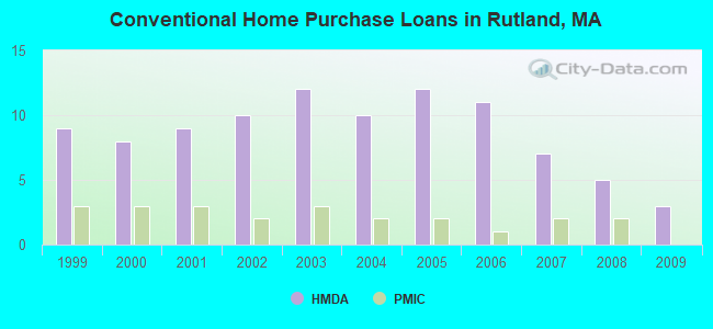
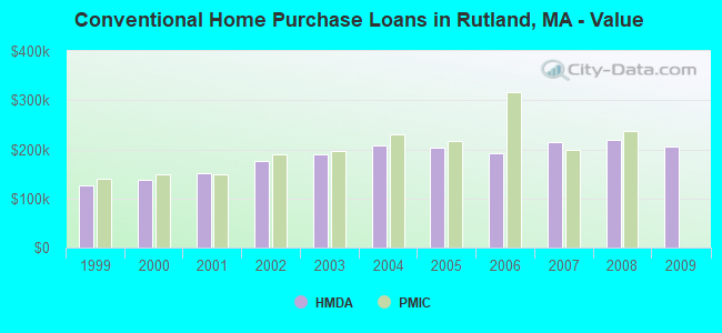
| Home Mortgage Disclosure Act Aggregated Statistics For Year 2009 (Based on 1 partial tract) | ||||||||
| A) FHA, FSA/RHS & VA Home Purchase Loans | B) Conventional Home Purchase Loans | C) Refinancings | D) Home Improvement Loans | |||||
|---|---|---|---|---|---|---|---|---|
| Number | Average Value | Number | Average Value | Number | Average Value | Number | Average Value | |
| LOANS ORIGINATED | 2 | $308,070 | 3 | $204,870 | 18 | $210,911 | 1 | $158,470 |
| APPLICATIONS APPROVED, NOT ACCEPTED | 0 | $0 | 0 | $0 | 1 | $277,990 | 0 | $0 |
| APPLICATIONS DENIED | 0 | $0 | 0 | $0 | 5 | $240,198 | 1 | $56,400 |
| APPLICATIONS WITHDRAWN | 0 | $0 | 1 | $124,330 | 3 | $245,730 | 0 | $0 |
| FILES CLOSED FOR INCOMPLETENESS | 0 | $0 | 0 | $0 | 2 | $184,095 | 0 | $0 |
Detailed HMDA statistics for the following Tracts: 7211.00
| Private Mortgage Insurance Companies Aggregated Statistics For Year 2009 (Based on 1 partial tract) | ||
| B) Refinancings | ||
|---|---|---|
| Number | Average Value | |
| LOANS ORIGINATED | 1 | $221,430 |
| APPLICATIONS APPROVED, NOT ACCEPTED | 0 | $0 |
| APPLICATIONS DENIED | 0 | $0 |
| APPLICATIONS WITHDRAWN | 0 | $0 |
| FILES CLOSED FOR INCOMPLETENESS | 0 | $0 |
Detailed PMIC statistics for the following Tracts: 7211.00
2002 - 2018 National Fire Incident Reporting System (NFIRS) incidents
- Fire incident types reported to NFIRS in Rutland, MA
- 21747.0%Structure Fires
- 16836.4%Outside Fires
- 439.3%Other
- 347.4%Mobile Property/Vehicle Fires
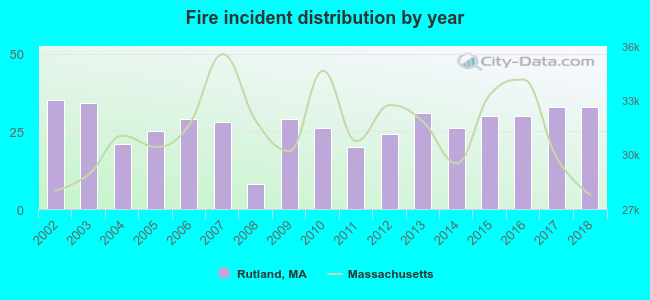 Based on the data from the years 2002 - 2018 the average number of fires per year is 27. The highest number of reported fires - 35 took place in 2002, and the least - 8 in 2008. The data has a dropping trend.
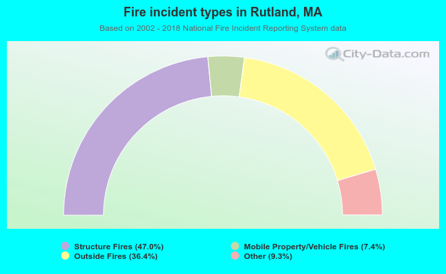 When looking into fire subcategories, the most incidents belonged to: Structure Fires (47.0%), and Outside Fires (36.4%).
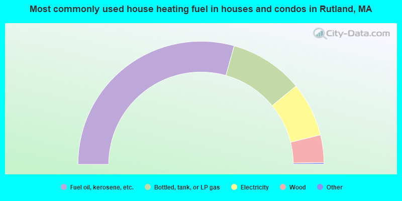
- 58.9%Fuel oil, kerosene, etc.
- 19.4%Bottled, tank, or LP gas
- 14.3%Electricity
- 7.3%Wood
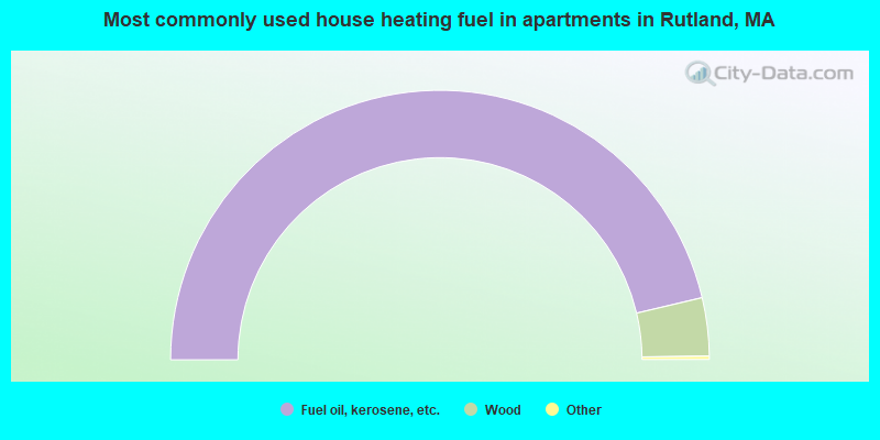
- 93.0%Fuel oil, kerosene, etc.
- 7.0%Wood
Rutland compared to Massachusetts state average:
- Median house value below state average.
- Unemployed percentage significantly below state average.
- Black race population percentage significantly below state average.
- Hispanic race population percentage significantly below state average.
- Foreign-born population percentage significantly below state average.
- Renting percentage below state average.
- Length of stay since moving in above state average.
- House age below state average.
Rutland on our top lists:
- #4 on the list of "Top 101 cities with the largest percentage of people in homes for the mentally ill (population 1,000+)"
- #52 (01543) on the list of "Top 101 zip codes with the largest percentage of Lithuanian first ancestries (pop 5,000+)"
- #4 on the list of "Top 101 counties with the highest carbon monoxide air pollution readings in 2012 (ppm)"
- #5 on the list of "Top 101 counties with the most Catholic congregations"
- #12 on the list of "Top 101 counties with the highest surface withdrawal of fresh water for public supply"
- #16 on the list of "Top 101 counties with the highest total withdrawal of fresh water for public supply"
- #23 on the list of "Top 101 counties with the highest Sulfur Oxides Annual air pollution readings in 2012 (µg/m3)"

|
|
Total of 113 patent applications in 2008-2024.