South Shore, Washington
Submit your own pictures of this place and show them to the world
- OSM Map
- General Map
- Google Map
- MSN Map

| Males: 2,419 | |
| Females: 2,443 |
| Median resident age: | 45.3 years |
| Washington median age: | 35.3 years |
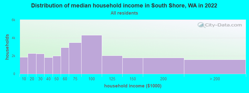
| South Shore: | $56,911 |
| WA: | $91,306 |
Estimated per capita income in 2022: $36,888 (it was $18,942 in 2000)
South Shore CCD income, earnings, and wages data
Estimated median house or condo value in 2022: $287,097 (it was $89,300 in 2000)
| South Shore: | $287,097 |
| WA: | $569,500 |
Mean prices in 2022: all housing units: $274,506; detached houses: $297,323; townhouses or other attached units: $218,689; in 2-unit structures: $252,387; in 5-or-more-unit structures: $250,787; mobile homes: $122,211; occupied boats, rvs, vans, etc.: $215,521
Detailed information about poverty and poor residents in South Shore, WA


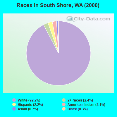
- 4,22192.2%White alone
- 1092.4%Two or more races
- 1012.2%Hispanic
- 952.1%American Indian alone
- 300.7%Asian alone
- 160.3%Black alone
- 30.07%Other race alone
- 20.04%Native Hawaiian and Other
Pacific Islander alone
Races in South Shore detailed stats: ancestries, foreign born residents, place of birth
 Recent articles from our blog. Our writers, many of them Ph.D. graduates or candidates, create easy-to-read articles on a wide variety of topics.
Current Local Time: PST time zone
Land area: 114.5 square miles.
Population density: 42 people per square mile (very low).

| South Shore CCD: | 1.2% ($1,111) |
| Washington: | 1.2% ($1,915) |
Nearest city with pop. 50,000+: Lakewood, WA  (73.4 miles , pop. 58,211).
Nearest city with pop. 200,000+: Seattle, WA (94.8 miles , pop. 563,374).
Nearest city with pop. 1,000,000+: Los Angeles, CA (932.5 miles , pop. 3,694,820).
Nearest cities:
), Latitude: 46.88 N, Longitude: 124.02 W
Area code commonly used in this area: 360

| Here: | 7.4% |
| Washington: | 4.6% |
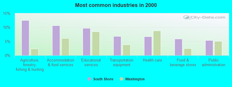
- Agriculture, forestry, fishing & hunting (12.5%)
- Accommodation & food services (10.6%)
- Educational services (9.7%)
- Transportation equipment (6.9%)
- Health care (6.7%)
- Food & beverage stores (5.9%)
- Public administration (5.4%)
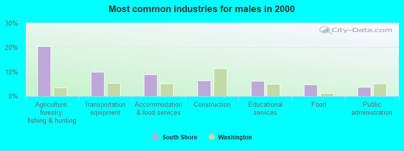
- Agriculture, forestry, fishing & hunting (20.5%)
- Transportation equipment (9.9%)
- Accommodation & food services (9.0%)
- Construction (6.4%)
- Educational services (6.1%)
- Food (4.7%)
- Public administration (3.8%)
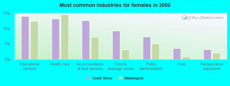
- Educational services (13.9%)
- Health care (13.2%)
- Accommodation & food services (12.6%)
- Food & beverage stores (9.2%)
- Public administration (7.3%)
- Food (3.5%)
- Transportation equipment (3.2%)
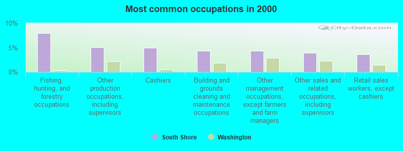
- Fishing, hunting, and forestry occupations (7.9%)
- Other production occupations, including supervisors (5.0%)
- Cashiers (5.0%)
- Building and grounds cleaning and maintenance occupations (4.3%)
- Other management occupations, except farmers and farm managers (4.3%)
- Other sales and related occupations, including supervisors (3.9%)
- Retail sales workers, except cashiers (3.6%)
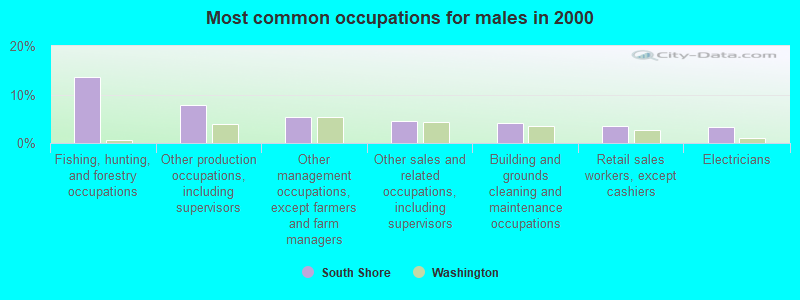
- Fishing, hunting, and forestry occupations (13.5%)
- Other production occupations, including supervisors (7.9%)
- Other management occupations, except farmers and farm managers (5.4%)
- Other sales and related occupations, including supervisors (4.5%)
- Building and grounds cleaning and maintenance occupations (4.1%)
- Retail sales workers, except cashiers (3.5%)
- Electricians (3.3%)
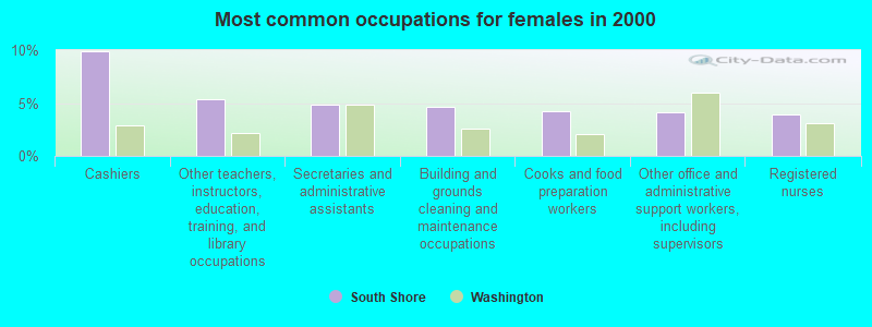
- Cashiers (9.9%)
- Other teachers, instructors, education, training, and library occupations (5.3%)
- Secretaries and administrative assistants (4.9%)
- Building and grounds cleaning and maintenance occupations (4.6%)
- Cooks and food preparation workers (4.2%)
- Other office and administrative support workers, including supervisors (4.1%)
- Registered nurses (4.0%)
Average climate in South Shore, Washington
Based on data reported by over 4,000 weather stations


(lower is better)
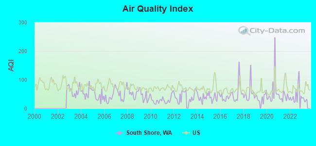
Air Quality Index (AQI) level in 2022 was 49.2. This is significantly better than average.
| City: | 49.2 |
| U.S.: | 72.6 |
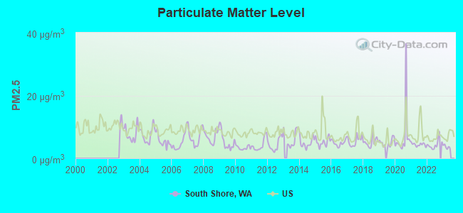
Particulate Matter (PM2.5) [µg/m3] level in 2022 was 4.44. This is significantly better than average. Closest monitor was 11.3 miles away from the city center.
| City: | 4.44 |
| U.S.: | 8.11 |
Earthquake activity:
South Shore-area historical earthquake activity is significantly above Washington state average. It is 1217% greater than the overall U.S. average.On 4/13/1949 at 19:55:42, a magnitude 7.0 (7.0 UK, Class: Major, Intensity: VIII - XII) earthquake occurred 76.3 miles away from the city center, causing $80,000,000 total damage
On 2/28/2001 at 18:54:32, a magnitude 6.8 (6.8 MD, Depth: 32.2 mi, Class: Strong, Intensity: VII - IX) earthquake occurred 64.0 miles away from the city center
On 2/28/2001 at 18:54:32, a magnitude 6.8 (6.5 MB, 6.6 MS, 6.8 MW) earthquake occurred 69.7 miles away from South Shore center, causing $2,000,000,000 total damage and $305,000,000 insured losses
On 4/29/1965 at 15:28:43, a magnitude 6.6 (6.6 UK) earthquake occurred 85.2 miles away from South Shore center, causing $28,000,000 total damage
On 7/3/1999 at 01:43:54, a magnitude 5.8 (5.4 MB, 5.5 MS, 5.8 MW, 5.3 ME, Depth: 25.2 mi, Class: Moderate, Intensity: VI - VII) earthquake occurred 39.4 miles away from the city center
On 1/31/1922 at 13:17:28, a magnitude 7.6 (7.6 UK) earthquake occurred 433.9 miles away from South Shore center
Magnitude types: body-wave magnitude (MB), duration magnitude (MD), energy magnitude (ME), surface-wave magnitude (MS), moment magnitude (MW)
Natural disasters:
The number of natural disasters in Grays Harbor County (28) is a lot greater than the US average (15).Major Disasters (Presidential) Declared: 25
Emergencies Declared: 1
Causes of natural disasters: Floods: 21, Storms: 15, Mudslides: 12, Landslides: 10, Winter Storms: 7, Winds: 4, Heavy Rains: 2, Snows: 2, Tornadoes: 2, Earthquake: 1, Hurricane: 1, Volcanic Eruption: 1, Other: 1 (Note: some incidents may be assigned to more than one category).
Hospitals and medical centers near South Shore:
- HARBORS HOME HEALTH/HOSPICE (Home Health Center, about 10 miles away; HOQUIAM, WA)
- FMC ABERDEEN (Dialysis Facility, about 11 miles away; ABERDEEN, WA)
- HOQUIAM HEALTHCARE, INC DBA PACIFIC CARE CENTER (Nursing Home, about 11 miles away; HOQUIAM, WA)
- GRAYS HARBOR CONVALESCENT CENTER (Nursing Home, about 12 miles away; ABERDEEN, WA)
- GRAYS HARBOR HEALTH AND REHABILITATION CENTER (Nursing Home, about 12 miles away; ABERDEEN, WA)
- GRAYS HARBOR COMMUNITY HOSPITAL Acute Care Hospitals (about 12 miles away; ABERDEEN, WA)
- COMMUNITY HOSPITAL HOSPICE (Hospital, about 13 miles away; ABERDEEN, WA)
Colleges/universities with over 2000 students nearest to South Shore:
- The Evergreen State College (about 52 miles; Olympia, WA; Full-time enrollment: 4,613)
- Centralia College (about 52 miles; Centralia, WA; FT enrollment: 2,354)
- South Puget Sound Community College (about 53 miles; Olympia, WA; FT enrollment: 3,981)
- Pierce College at Fort Steilacoom (about 72 miles; Lakewood, WA; FT enrollment: 5,228)
- Lower Columbia College (about 73 miles; Longview, WA; FT enrollment: 2,595)
- Clover Park Technical College (about 75 miles; Lakewood, WA; FT enrollment: 4,185)
- Tacoma Community College (about 76 miles; Tacoma, WA; FT enrollment: 6,622)
Points of interest:
Notable locations in South Shore: Roberts Farm (A), Benn (B), Western (C), Westport Marina (D), Westport Wastewater Treatment Plant (E), Grays Harbor CG (F), Grays Harbor Fire District 11 (G), South Beach Ambulance Service (H), Grays Harbor Fire District 14 (I), South Beach Ambulance Service (J), City of Westport Fire Department (K), Westport City Hall (L), Westport Maritime Museum (M), Grays Harbor Lighthouse (N), Westport Timberland Library (O). Display/hide their locations on the map
Churches in South Shore include: Saint Christopher Episcopal Church (A), Coastal Community Church (B), Twin Harbor Baptist Church (C), South Beach Christian Center (D), Kingdom Hall of Jehovahs Witnesses (E), Saint Paul's Catholic Church (F), The Church of Jesus Christ of Latter Day Saints (G). Display/hide their locations on the map
Lakes: Horseshoe Lake (A), Cohassett Lake (B). Display/hide their locations on the map
Streams, rivers, and creeks: Andrews Creek (A), Atwood Creek (B), Ballon Creek (C), Barlow Creek (D), Beardslee Slough (E), Beaver Creek (F), Bluff Creek (G), Campbell Creek (H), Chapin Creek (I). Display/hide their locations on the map
Parks in South Shore include: Westhaven State Park (1), Grayland Access State Park (2), Johns River State Wildlife Recreation Area (3), Westport Light State Park (4), Twin Harbors Beach State Park (5). Display/hide their locations on the map
| This place: | 2.1 people |
| Washington: | 2.5 people |
| This place: | 45.9% |
| Whole state: | 66.5% |
| This place: | 7.6% |
| Whole state: | 6.1% |
Likely homosexual households (counted as self-reported same-sex unmarried-partner households)
- Lesbian couples: 0.1% of all households
- Gay men: 0.4% of all households
| This place: | 15.7% |
| Whole state: | 10.6% |
| This place: | 5.6% |
| Whole state: | 4.6% |
For population 15 years and over in South Shore:
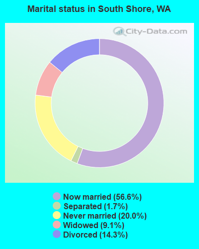
- Never married: 20.0%
- Now married: 56.6%
- Separated: 1.7%
- Widowed: 9.1%
- Divorced: 14.3%
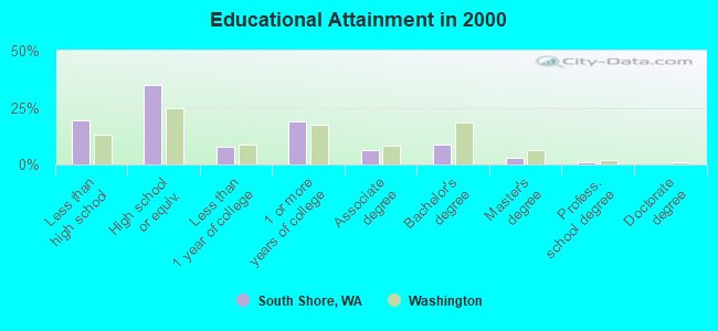
For population 25 years and over in South Shore:
- High school or higher: 80.8%
- Bachelor's degree or higher: 12.9%
- Graduate or professional degree: 4.4%
- Unemployed: 6.9%
- Mean travel time to work (commute): 20.2 minutes
| Here: | 10.5 |
| Washington average: | 11.3 |
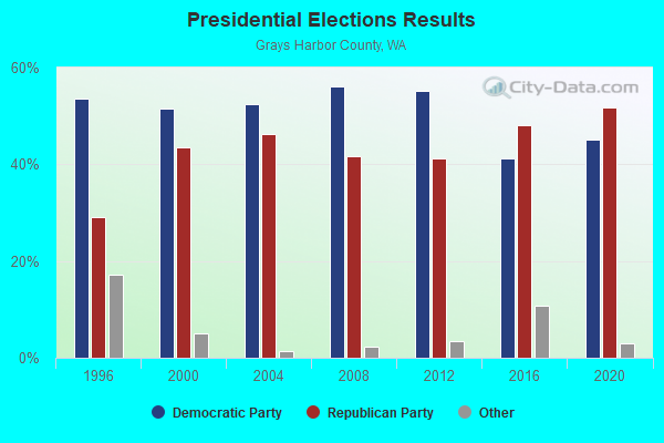
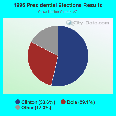
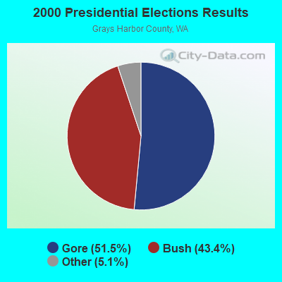
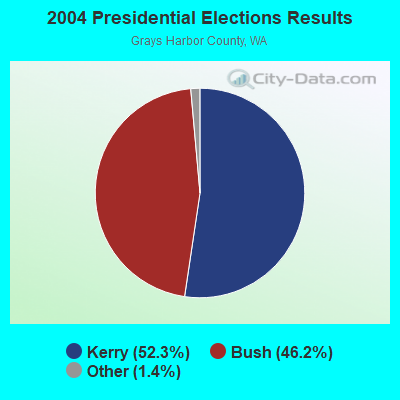
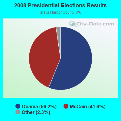

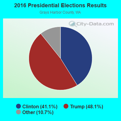
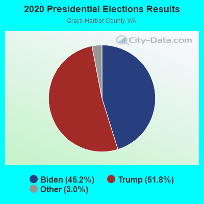
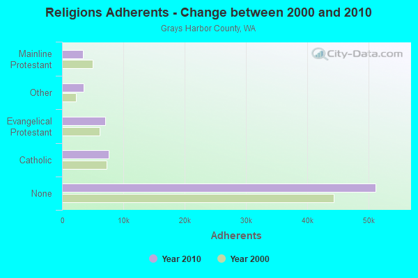
Graphs represent county-level data. Detailed 2008 Election Results
Religion statistics for South Shore, WA (based on Grays Harbor County data)
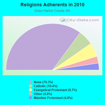
| Religion | Adherents | Congregations |
|---|---|---|
| Catholic | 7,602 | 8 |
| Evangelical Protestant | 7,083 | 58 |
| Other | 3,506 | 14 |
| Mainline Protestant | 3,459 | 25 |
| None | 51,147 | - |
Food Environment Statistics:
| Grays Harbor County: | 3.51 / 10,000 pop. |
| Washington: | 2.06 / 10,000 pop. |
| Here: | 2.95 / 10,000 pop. |
| State: | 1.18 / 10,000 pop. |
| Here: | 4.21 / 10,000 pop. |
| Washington: | 2.67 / 10,000 pop. |
| This county: | 8.99 / 10,000 pop. |
| Washington: | 8.26 / 10,000 pop. |
| Grays Harbor County: | 11.0% |
| Washington: | 7.7% |
| This county: | 33.8% |
| Washington: | 25.7% |
| This county: | 18.4% |
| Washington: | 13.9% |
Strongest AM radio stations in South Shore:
- KXRO (1320 AM; 5 kW; ABERDEEN, WA; Owner: MCC RADIO, LLC)
- KIRO (710 AM; 50 kW; SEATTLE, WA; Owner: ENTERCOM SEATTLE LICENSE, LLC)
- KTTH (770 AM; 50 kW; SEATTLE, WA; Owner: ENTERCOM SEATTLE LICENSE, LLC)
- KGNW (820 AM; 50 kW; BURIEN-SEATTLE, WA; Owner: INSPIRATION MEDIA, INC.)
- KJR (950 AM; 50 kW; SEATTLE, WA)
- KOMO (1000 AM; 50 kW; SEATTLE, WA; Owner: FISHER BROADCASTING - SEATTLE RADIO, L.L.C.)
- KYCW (1090 AM; 50 kW; SEATTLE, WA; Owner: INFINITY RADIO SUBSIDIARY OPERATIONS INC.)
- KWOK (1490 AM; 1 kW; HOQUIAM, WA; Owner: MCC RADIO, LLC)
- KBKW (1450 AM; 1 kW; ABERDEEN, WA; Owner: JODESHA BROADCASTING, INC.)
- KIXI (880 AM; 50 kW; MERCER ISLAND/SEATTL, WA; Owner: BELLEVUE RADIO, INC.)
- KPOJ (620 AM; 50 kW; PORTLAND, OR; Owner: CITICASTERS LICENSES, L.P.)
- KKOL (1300 AM; 50 kW; SEATTLE, WA; Owner: INSPIRATION MEDIA, INC.)
- KPAM (860 AM; 50 kW; TROUTDALE, OR; Owner: PAMPLIN BROADCASTING-OREGON, INC.)
Strongest FM radio stations in South Shore:
- KFMY (97.7 FM; RAYMOND, WA; Owner: SOUTH SOUND BROADCASTING, LLC)
- KAYO-FM (99.3 FM; ELMA, WA; Owner: SOUTH SOUND BROADCASTING, LLC)
- KJET (105.7 FM; SOUTH BEND, WA; Owner: JODESHA BROADCASTING, INC.)
- KXXK (95.3 FM; HOQUIAM, WA; Owner: MCC RADIO, LLC)
- KMNT (102.9 FM; CENTRALIA, WA; Owner: CITICASTERS LICENSES, L.P.)
- KDUX-FM (104.7 FM; ABERDEEN, WA; Owner: MCC RADIO, LLC)
- K205EN (88.9 FM; ABERDEEN, WA; Owner: CALVARY CHAPEL OF TWIN FALLS, INC.)
- K207DB (89.3 FM; ABERDEEN, WA; Owner: EDUCATIONAL MEDIA FOUNDATION)
- K216DH (91.1 FM; CATHLAMET, WA; Owner: TILLICUM FOUNDATION)
- KSWW (102.1 FM; MONTESANO, WA; Owner: JODESHA BROADCASTING, INC.)
- KMUN (91.9 FM; ASTORIA, OR; Owner: TILLICUM FOUNDATION)
- KGY-FM (96.9 FM; MCCLEARY, WA; Owner: KGY, INC.)
- KWYA (89.7 FM; ASTORIA, OR; Owner: WAY-FM MEDIA GROUP, INC.)
TV broadcast stations around South Shore:
- K23AS (Channel 23; ABERDEEN, WA; Owner: TRINITY BROADCASTING NETWORK)
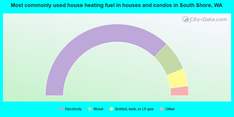
- 74.5%Electricity
- 13.3%Wood
- 7.9%Bottled, tank, or LP gas
- 3.7%Fuel oil, kerosene, etc.
- 0.6%Other fuel
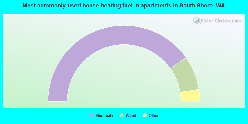
- 80.5%Electricity
- 14.5%Wood
- 2.8%Bottled, tank, or LP gas
- 1.4%Fuel oil, kerosene, etc.
- 0.9%Other fuel
South Shore compared to Washington state average:
- Median household income below state average.
- Median house value below state average.
- Unemployed percentage below state average.
- Black race population percentage significantly below state average.
- Hispanic race population percentage significantly below state average.
- Median age significantly above state average.
- Foreign-born population percentage significantly below state average.
- Renting percentage significantly below state average.
- Length of stay since moving in significantly above state average.
- Number of rooms per house significantly below state average.
- House age significantly below state average.
- Percentage of population with a bachelor's degree or higher below state average.