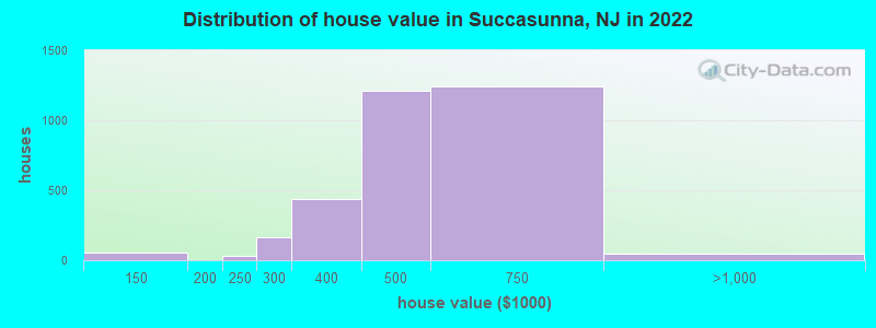
Estimated median house or condo value in 2022: $546,600
Succasunna:
$546,600
NJ:
$428,900
Mean prices in 2022:all housing units: $509,709; detached houses: $516,406; townhouses or other attached units: $298,577; in 5-or-more-unit structures: $281,761
Median gross rent in 2022: $2,048.
March 2022 cost of living index in Succasunna: 114.6 (more than average, U.S. average is 100)Percentage of residents living in poverty in 2022: 2.9%
(1.7% for White Non-Hispanic residents, 24.6% for Black residents, 4.6% for Hispanic or Latino residents, 14.2% for other race residents, 3.9% for two or more races residents)
According to our research of New Jersey and other state lists, there was 1 registered sex offender living in Succasunna, New Jersey as of May 01, 2024. The ratio of all residents to sex offenders in Succasunna is 8,877 to 1. The ratio of registered sex offenders to all residents in this city is much lower than the state average.
Recent articles from our blog. Our writers, many of them Ph.D. graduates or candidates, create easy-to-read articles on a wide variety of topics.
Ancestries: Italian (19.8%), Irish (6.3%), German (5.9%), Polish (5.6%), American (5.2%), English (4.2%).
Current Local Time: EST time zone
Elevation: 713 feet
1,507 residents are foreign born (5.9% Latin America, 5.1% Asia, 3.4% Europe).
This place:
15.3%
New Jersey:
23.2%
Median real estate property taxes paid for housing units with mortgages in 2022: $10,001 (2.0%) Median real estate property taxes paid for housing units with no mortgage in 2022: $10,000 (2.2%)
Nearest city with pop. 50,000+: Wayne, NJ (21.0 miles , pop. 54,069).
Nearest city with pop. 200,000+: Newark, NJ (25.6 miles , pop. 273,546).
Nearest city with pop. 1,000,000+: Manhattan, NY (35.6 miles , pop. 1,537,195).
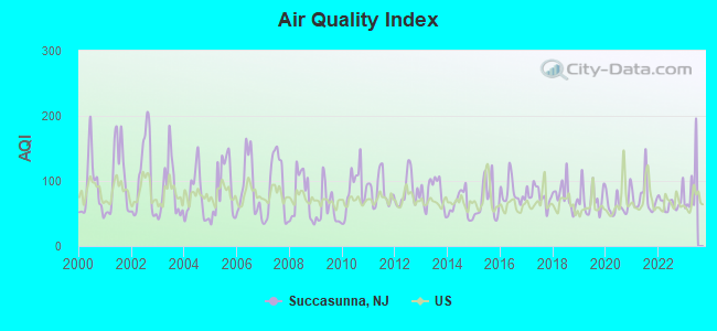
Air Quality Index (AQI) level in 2022 was 67.7. This is about average.
City:
67.7
U.S.:
72.6
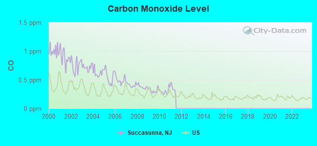
Carbon Monoxide (CO) [ppm] level in 2010 was 0.301. This is about average.Closest monitor was 9.6 miles away from the city center.
City:
0.301
U.S.:
0.251
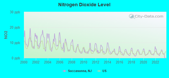
Nitrogen Dioxide (NO2) [ppb] level in 2022 was 3.45. This is significantly better than average.Closest monitor was 5.9 miles away from the city center.
City:
3.45
U.S.:
5.11
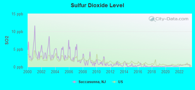
Sulfur Dioxide (SO2) [ppb] level in 2022 was 0.537. This is significantly better than average.Closest monitor was 5.9 miles away from the city center.
City:
0.537
U.S.:
1.515
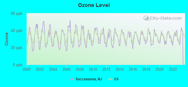
Ozone [ppb] level in 2022 was 32.3. This is about average.Closest monitor was 5.9 miles away from the city center.
City:
32.3
U.S.:
33.3
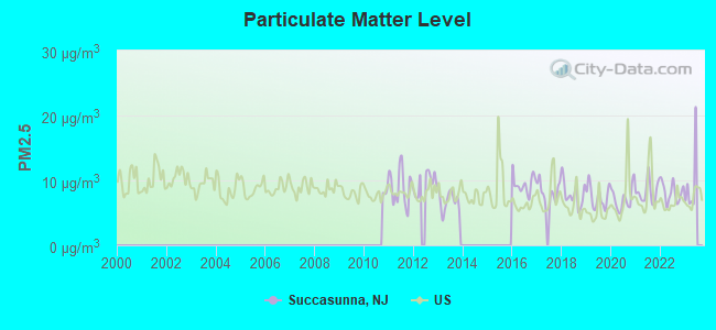
Particulate Matter (PM2.5) [µg/m3] level in 2022 was 8.18. This is about average.Closest monitor was 5.9 miles away from the city center.
City:
8.18
U.S.:
8.11
Tornado activity:
Succasunna-area historical tornado activity is near New Jersey state average. It is 26% smaller than the overall U.S. average.
On 5/28/1973, a category F3 (max. wind speeds 158-206 mph) tornado 4.3 miles away from the Succasunna place center injured 12 peopleand causedbetween $50,000 and $500,000 in damages.
On 5/28/1973, a category F3 tornado 8.8 miles away from the place center causedbetween $50,000 and $500,000 in damages.
Earthquake activity:
Succasunna-area historical earthquake activity is significantly above New Jersey state average. It is 67% smaller than the overall U.S. average.
On 8/23/2011 at 17:51:04, a magnitude 5.8 (5.8 MW, Depth: 3.7 mi, Class: Moderate, Intensity: VI - VII) earthquake occurred 270.0 miles away from Succasunna center On 10/7/1983 at 10:18:46, a magnitude 5.3 (5.1 MB, 5.3 LG, 5.1 ML) earthquake occurred 213.9 miles away from the city center On 1/16/1994 at 01:49:16, a magnitude 4.6 (4.6 MB, 4.6 LG, Depth: 3.1 mi, Class: Light, Intensity: IV - V) earthquake occurred 82.2 miles away from Succasunna center On 4/20/2002 at 10:50:47, a magnitude 5.3 (5.3 ML, Depth: 3.0 mi) earthquake occurred 256.6 miles away from the city center On 4/20/2002 at 10:50:47, a magnitude 5.2 (5.2 MB, 4.2 MS, 5.2 MW, 5.0 MW) earthquake occurred 254.6 miles away from Succasunna center On 1/16/1994 at 00:42:43, a magnitude 4.2 (4.2 MB, 4.0 LG, Depth: 3.1 mi) earthquake occurred 80.9 miles away from Succasunna center Magnitude types: regional Lg-wave magnitude (LG), body-wave magnitude (MB), local magnitude (ML), surface-wave magnitude (MS), moment magnitude (MW)
Natural disasters:
The number of natural disasters in Morris County (29) is a lot greater than the US average (15). Major Disasters (Presidential) Declared: 19 Emergencies Declared: 9
Causes of natural disasters: Floods: 8, Hurricanes: 7, Storms: 7, Snowstorms: 4, Heavy Rains: 3, Winter Storms: 3, Blizzards: 2, Water Shortages: 2, Mudslide: 1, Tornado: 1, Tropical Storm: 1, Wind: 1, Other: 3 (Note: some incidents may be assigned to more than one category).
Hospitals and medical centers in Succasunna:
MERRY HEART NH (200 RTE10)
MERRY HEART NURSING HOME (200 RT 10 WEST)
MMH DCNWJ SUCCASUNNA (DIALYSIS CENTER OF NORTHWEST JERSEY)
Colleges/universities with over 2000 students nearest to Succasunna:
County College of Morris (about 4 miles; Randolph, NJ; Full-time enrollment: 6,427)
Centenary College (about 11 miles; Hackettstown, NJ; FT enrollment: 2,271)
Fairleigh Dickinson University-College at Florham (about 13 miles; Madison, NJ; FT enrollment: 2,690)
Drew University (about 14 miles; Madison, NJ; FT enrollment: 2,272)
Sussex County Community College (about 16 miles; Newton, NJ; FT enrollment: 2,402)
Raritan Valley Community College (about 18 miles; Branchburg, NJ; FT enrollment: 5,735)
Union County College (about 22 miles; Cranford, NJ; FT enrollment: 9,148)
Public high school in Succasunna:
ROXBURY HIGH SCHOOL DISTRICT (Location: ONE BRYANT DRIVE, Grades: 9-12)
Private high school in Succasunna:
AMERICAN CHRISTIAN SCHOOL (Students: 160, Location: 126 S HILLSIDE AVE, Grades: PK-11)
ROXBURY PUBLIC LIBRARY (Operating income: $1,357,741; Location: 103 MAIN STREET; 82,949 books; 3,586 audio materials; 3,165 video materials; 22 state licensed databases; 4 other licensed databases; 125 print serial subscriptions; 1 electronic serial subscriptions)
Morris County has a predicted average indoor radon screening level greater than 4 pCi/L (pico curies per liter) - Highest Potential
Drinking water stations with addresses in Succasunna and their reported violations in the past:
ROXBURY WATER CO (Population served: 11,230, Groundwater):
Past health violations:
MCL, Monthly (TCR) - In JUL-2009, Contaminant: Coliform. Follow-up actions: St Compliance achieved (AUG-06-2009), St Public Notif received (AUG-10-2009), St Public Notif requested (AUG-16-2009), St Formal NOV issued (AUG-16-2009)
MCL, Acute (TCR) - In MAY-2008, Contaminant: Coliform. Follow-up actions: St Public Notif received (MAY-14-2008), St Public Notif requested (MAY-16-2008), St Formal NOV issued (MAY-16-2008), St Compliance achieved (JUN-30-2008)
Past monitoring violations:
Monitoring and Reporting (DBP) - Between JAN-2014 and MAR-2014, Contaminant: Chlorine. Follow-up actions: St Formal NOV issued (APR-28-2014), St Compliance achieved (MAY-06-2014)
Monitoring and Reporting (DBP) - Between JAN-2014 and MAR-2014, Contaminant: Chlorine. Follow-up actions: St Formal NOV issued (APR-28-2014), St Compliance achieved (MAY-06-2014)
Monitoring and Reporting (DBP) - Between JAN-2014 and MAR-2014, Contaminant: Chlorine. Follow-up actions: St Formal NOV issued (APR-28-2014), St Compliance achieved (MAY-06-2014)
21 regular monitoring violations
STADIUM BAR & GRILL (Population served: 83, Groundwater):
Past health violations:
MCL, Acute (TCR) - In APR-2014, Contaminant: Coliform. Follow-up actions: St Public Notif requested (APR-28-2014), St Public Notif received (APR-28-2014), St Formal NOV issued (APR-28-2014)
MCL, Monthly (TCR) - In APR-2014, Contaminant: Coliform
MCL, Monthly (TCR) - In MAR-2014, Contaminant: Coliform. Follow-up actions: St Public Notif requested (MAR-31-2014), St Formal NOV issued (MAR-31-2014), St Public Notif received (APR-04-2014)
Past monitoring violations:
Monitoring, Repeat Major (TCR) - Between JAN-2014 and MAR-2014, Contaminant: Coliform (TCR). Follow-up actions: St Compliance achieved (MAR-27-2014), St Formal NOV issued (APR-15-2014)
Average household size:
This place:
2.9 people
New Jersey:
2.7 people
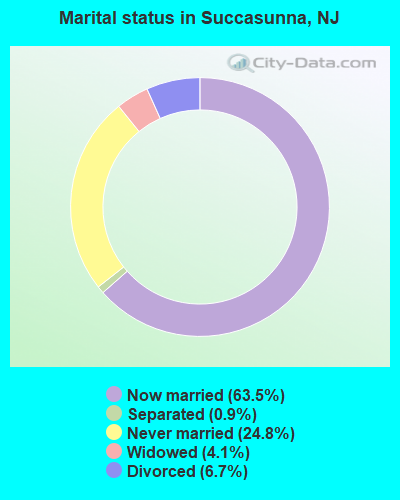
Percentage of family households:
This place:
85.2%
Whole state:
69.3%
Percentage of households with unmarried partners:
This place:
2.6%
Whole state:
5.9%
Likely homosexual households (counted as self-reported same-sex unmarried-partner households)
Lesbian couples: 0.3% of all households
Gay men: 0.1% of all households
2 people in other noninstitutional facilities in 2010
Banks with branches in Succasunna (2011 data):
Investors Bank: Succasunna Branch at 275-33 Route 10 East, branch established on 1998/03/23. Info updated 2012/02/27: Bank assets: $10,674.9 mil, Deposits: $7,419.7 mil, headquarters in Short Hills, NJ, positive income, Commercial Lending Specialization, 86 total offices, Holding Company: Investors Bancorp, Mhc
Fulton Bank of New Jersey: Roxbury Branch at 274 Route 10, branch established on 1995/12/18. Info updated 2012/02/08: Bank assets: $3,408.9 mil, Deposits: $2,816.1 mil, headquarters in Mount Laurel, NJ, negative income in the last year, Commercial Lending Specialization, 74 total offices, Holding Company: Fulton Financial Corporation
TD Bank, National Association: Roxbury Branch at 240 Route 10, branch established on 2004/12/29. Info updated 2010/10/04: Bank assets: $188,912.6 mil, Deposits: $153,149.8 mil, headquarters in Wilmington, DE, positive income, 1314 total offices, Holding Company: Toronto-Dominion Bank, The
Wells Fargo Bank, National Association: Succasunna Branch at 106 Route 10, branch established on 1983/01/01. Info updated 2011/04/05: Bank assets: $1,161,490.0 mil, Deposits: $905,653.0 mil, headquarters in Sioux Falls, SD, positive income, 6395 total offices, Holding Company: Wells Fargo & Company
Valley National Bank: 250 Route 10 Branch at 250 Route 10, branch established on 1925/01/01. Info updated 2012/01/10: Bank assets: $14,186.7 mil, Deposits: $9,715.7 mil, headquarters in Wayne, NJ, positive income, Commercial Lending Specialization, 219 total offices, Holding Company: Valley National Bancorp
JPMorgan Chase Bank, National Association: Roxbury Branch at Route 46 Arlington Road, branch established on 1988/03/07. Info updated 2011/11/10: Bank assets: $1,811,678.0 mil, Deposits: $1,190,738.0 mil, headquarters in Columbus, OH, positive income, International Specialization, 5577 total offices, Holding Company: Jpmorgan Chase & Co.
Bank of America, National Association: Roxbury Branch at 15 Commerce Boulevard, branch established on 1966/12/10. Info updated 2009/11/18: Bank assets: $1,451,969.3 mil, Deposits: $1,077,176.8 mil, headquarters in Charlotte, NC, positive income, 5782 total offices, Holding Company: Bank Of America Corporation
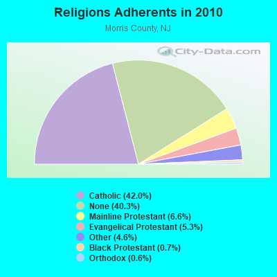
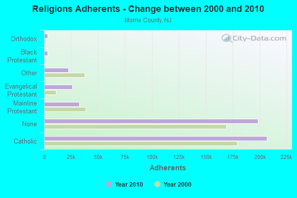
Religion statistics for Succasunna, NJ (based on Morris County data)
Religion
Adherents
Congregations
Catholic
206,700
49
Mainline Protestant
32,353
111
Evangelical Protestant
25,971
94
Other
22,414
43
Black Protestant
3,281
7
Orthodox
3,145
6
None
198,412
-
Source: Clifford Grammich, Kirk Hadaway, Richard Houseal, Dale E.Jones, Alexei Krindatch, Richie Stanley and Richard H.Taylor. 2012. 2010 U.S.Religion Census: Religious Congregations & Membership Study. Association of Statisticians of American Religious Bodies. Jones, Dale E., et al. 2002. Congregations and Membership in the United States 2000. Nashville, TN: Glenmary Research Center. Graphs represent county-level data
Food Environment Statistics:
Number of grocery stores: 103
Morris County:
2.12 / 10,000 pop.
New Jersey:
2.90 / 10,000 pop.
Number of supercenters and club stores: 5
This county:
0.10 / 10,000 pop.
New Jersey:
0.06 / 10,000 pop.
Number of convenience stores (no gas): 55
This county:
1.13 / 10,000 pop.
State:
1.76 / 10,000 pop.
Number of convenience stores (with gas): 43
Morris County:
0.88 / 10,000 pop.
New Jersey:
0.81 / 10,000 pop.
Number of full-service restaurants: 428
Morris County:
8.80 / 10,000 pop.
New Jersey:
7.15 / 10,000 pop.
Adult diabetes rate:
This county:
7.3%
State:
8.3%
Adult obesity rate:
Here:
20.4%
New Jersey:
23.3%
Low-income preschool obesity rate:
Here:
20.1%
New Jersey:
18.0%
7.05% of this county's 2020 resident taxpayers moved to other counties in 2021 ($142,356 average adjusted gross income)
Here:
7.05%
New Jersey average:
7.02%
0.01% of residents moved to foreign countries ($178 average AGI)
Morris County:
0.01%
New Jersey average:
0.02%
Top counties to which taxpayers relocated from this county between 2020 and 2021:
Aircraft: CESSNA 182T (Category: Land, Seats: 4, Weight: Up to 12,499 Pounds), Engine: LYCOMING IO-540 SER (300 HP) (Reciprocating) N-Number: 699CB, N699CB, N-699CB, Serial Number: 18281033, Year manufactured: 2001, Airworthiness Date: 11/29/2001, Certificate Issue Date: 02/02/2010 Registrant (LLC): Big Skylands Aviation LLC, 151 State Route 10 E Ste 105, Succasunna, NJ 07876
2002 - 2018 National Fire Incident Reporting System (NFIRS) incidents
According to the data from the years 2002 - 2018 the average number of fire incidents per year is 8. The highest number of fire incidents - 40 took place in 2014, and the least - 0 in 2003. The data has a rising trend.
When looking into fire subcategories, the most reports belonged to: Outside Fires (44.3%), and Structure Fires (42.1%).
Fire incident types reported to NFIRS in Succasunna, NJ
#30 on the list of "Top 101 cities with the smallest percentage of divorced people (15+ years)(population 5,000+)"
#44 on the list of "Top 101 cities with the lowest percentage of single-parent households, population 5,000+"
#58 on the list of "Top 101 cities with the most people living the same house as 1 year ago (population 5,000+))"
#4 on the list of "Top 101 counties with the largest decrease in the number of births per 1000 residents 2000-2006 to 2007-2013 (pop 50,000+)"
#8 on the list of "Top 101 counties with the lowest number of infant deaths per 1000 residents 2007-2013 (pop. 50,000+)"
#10 on the list of "Top 101 counties with the highest percentage of residents that visited a dentist within the past year"
#11 on the list of "Top 101 counties with the largest decrease in the number of infant deaths per 1000 residents 2000-2006 to 2007-2013 (pop. 50,000+)"
#12 on the list of "Top 101 counties with the best general health status score of residents (1-5), 3 years of data"


 Recent articles from our blog. Our writers, many of them Ph.D. graduates or candidates, create easy-to-read articles on a wide variety of topics.
 (21.0 miles
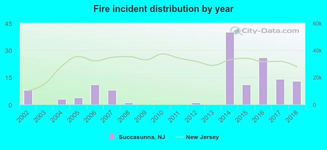 According to the data from the years 2002 - 2018 the average number of fire incidents per year is 8. The highest number of fire incidents - 40 took place in 2014, and the least - 0 in 2003. The data has a rising trend.
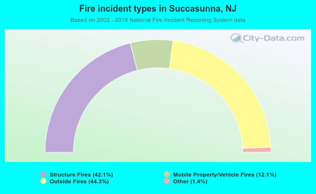 When looking into fire subcategories, the most reports belonged to: Outside Fires (44.3%), and Structure Fires (42.1%).