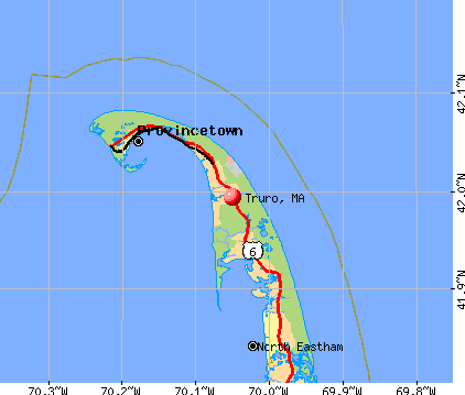
Truro, Massachusetts
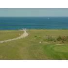
Truro: View of Atlantic Ocean from the top of the Cape Cod Lighthouse (Highland Lighthouse)
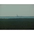
Truro: View of Provincetown Memorial from the Cape Cod Lighthouse (Highland Lighthouse)
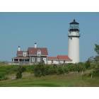
Truro: Cape Cod Lighthouse (Highland Lighthouse)
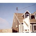
Truro: A Sunny, Breezy afternoon in Truro, 1980

Truro: Gazing up from the beach, August 1980
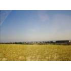
Truro: North Truro, MA: View of Route 6 From the Sand Dunes

Truro: Golden Sunset on a North Truro Beach
Truro: Paparazzi's
- add
your
Submit your own pictures of this town and show them to the world
- OSM Map
- General Map
- Google Map
- MSN Map
Population change since 2000: -4.0%
 |
| Males: 989 | |
| Females: 1,014 |
| Median resident age: | 53.7 years |
| Massachusetts median age: | 39.2 years |
Zip codes: 02666.
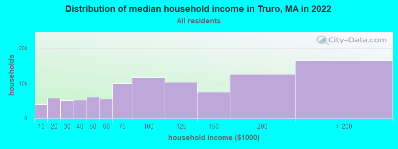
| Truro: | $85,562 |
| MA: | $94,488 |
Estimated per capita income in 2022: $53,905 (it was $22,608 in 2000)
Truro town income, earnings, and wages data
Estimated median house or condo value in 2022: over $1,000,000 (it was $289,600 in 2000)
| Truro: | over $1,000,000 |
| MA: | $534,700 |
Mean prices in 2022: all housing units: $623,757; detached houses: $648,447; townhouses or other attached units: $490,502; in 2-unit structures: $577,155; in 3-to-4-unit structures: $445,551; in 5-or-more-unit structures: $351,307; mobile homes: $108,058
Detailed information about poverty and poor residents in Truro, MA


- 1,88394.0%White alone
- 412.0%Hispanic
- 381.9%Black alone
- 241.2%Two or more races
- 100.5%Asian alone
- 40.2%Other race alone
- 30.1%American Indian alone
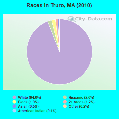
Races in Truro detailed stats: ancestries, foreign born residents, place of birth
Type |
2009 |
2010 |
2011 |
2012 |
2013 |
2014 |
2015 |
2016 |
2017 |
2018 |
2019 |
2020 |
2021 |
2022 |
|---|---|---|---|---|---|---|---|---|---|---|---|---|---|---|
| Murders (per 100,000) | 0 (0.0) | 0 (0.0) | 0 (0.0) | 0 (0.0) | 0 (0.0) | 0 (0.0) | 0 (0.0) | 0 (0.0) | 0 (0.0) | 0 (0.0) | 0 (0.0) | 0 (0.0) | 0 (0.0) | 1 (39.4) |
| Rapes (per 100,000) | 0 (0.0) | 0 (0.0) | 0 (0.0) | 0 (0.0) | 0 (0.0) | 2 (99.1) | 1 (49.7) | 0 (0.0) | 2 (99.1) | 0 (0.0) | 1 (50.4) | 0 (0.0) | 1 (49.4) | 0 (0.0) |
| Robberies (per 100,000) | 0 (0.0) | 0 (0.0) | 0 (0.0) | 0 (0.0) | 0 (0.0) | 0 (0.0) | 0 (0.0) | 0 (0.0) | 0 (0.0) | 0 (0.0) | 0 (0.0) | 0 (0.0) | 0 (0.0) | 0 (0.0) |
| Assaults (per 100,000) | 1 (46.5) | 0 (0.0) | 5 (248.1) | 4 (198.0) | 5 (248.0) | 6 (297.2) | 10 (496.5) | 6 (300.2) | 12 (594.6) | 5 (249.5) | 4 (201.6) | 4 (200.3) | 3 (148.2) | 2 (78.9) |
| Burglaries (per 100,000) | 10 (465.3) | 6 (299.6) | 18 (893.3) | 10 (495.0) | 12 (595.2) | 8 (396.2) | 7 (347.6) | 3 (150.1) | 7 (346.9) | 6 (299.4) | 0 (0.0) | 1 (50.1) | 4 (197.6) | 0 (0.0) |
| Thefts (per 100,000) | 15 (698.0) | 17 (848.7) | 31 (1,538) | 29 (1,436) | 23 (1,141) | 11 (544.8) | 28 (1,390) | 18 (900.5) | 13 (644.2) | 11 (548.9) | 5 (252.0) | 8 (400.6) | 8 (395.3) | 12 (473.2) |
| Auto thefts (per 100,000) | 0 (0.0) | 1 (49.9) | 0 (0.0) | 1 (49.5) | 0 (0.0) | 0 (0.0) | 0 (0.0) | 2 (100.1) | 3 (148.7) | 1 (49.9) | 0 (0.0) | 0 (0.0) | 0 (0.0) | 0 (0.0) |
| Arson (per 100,000) | 0 (0.0) | 0 (0.0) | 0 (0.0) | 0 (0.0) | 0 (0.0) | 1 (49.5) | 1 (49.7) | 1 (50.0) | 0 (0.0) | 0 (0.0) | 0 (0.0) | 0 (0.0) | 0 (0.0) | 0 (0.0) |
| City-Data.com crime index | 69.8 | 58.9 | 173.7 | 135.6 | 136.9 | 188.2 | 219.0 | 114.6 | 260.2 | 96.8 | 90.7 | 59.6 | 98.8 | 113.6 |
The City-Data.com crime index weighs serious crimes and violent crimes more heavily. Higher means more crime, U.S. average is 246.1. It adjusts for the number of visitors and daily workers commuting into cities.
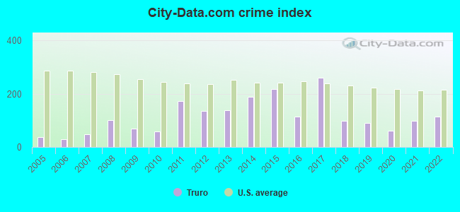
Crime rate in Truro detailed stats: murders, rapes, robberies, assaults, burglaries, thefts, arson
Full-time law enforcement employees in 2021, including police officers: 17 (12 officers - 12 male; 0 female).
| Officers per 1,000 residents here: | 5.93 |
| Massachusetts average: | 2.53 |
 Recent articles from our blog. Our writers, many of them Ph.D. graduates or candidates, create easy-to-read articles on a wide variety of topics.

 | 2021 Real Estate Observations (1729 replies) |
| The conflict over North End outdoor dining (188 replies) |
| Cape Cod observations from a 1st timer (77 replies) |
| What is the great appeal of Nantucket? (99 replies) |
| Retiring in a lower-priced town? (94 replies) |
| Mass. Democrats Ram Through an Abortion Bill Too Extreme for Their Pro-Choice Governor (188 replies) |
Latest news from Truro, MA collected exclusively by city-data.com from local newspapers, TV, and radio stations
Truro, MA City Guides:
Ancestries: Portuguese (25.7%), English (24.8%), Irish (20.6%), German (11.8%), Italian (7.6%), French (7.1%).
Current Local Time: EST time zone
Incorporated in 1709
Elevation: 25 feet
Land area: 21.1 square miles.
Population density: 95 people per square mile (very low).
70 residents are foreign born (1.3% Europe, 0.9% North America, 0.7% Latin America, 0.5% Asia).
| This town: | 3.4% |
| Massachusetts: | 12.2% |
| Truro town: | 0.5% ($1,503) |
| Massachusetts: | 1.3% ($2,336) |
Nearest city with pop. 50,000+: Weymouth, MA  (46.9 miles , pop. 53,988).
Nearest city with pop. 200,000+: Boston, MA (56.5 miles , pop. 589,141).
Nearest city with pop. 1,000,000+: Bronx, NY (213.0 miles , pop. 1,332,650).
Nearest cities:
Latitude: 42.01 N, Longitude: 70.07 W

Truro tourist attractions:
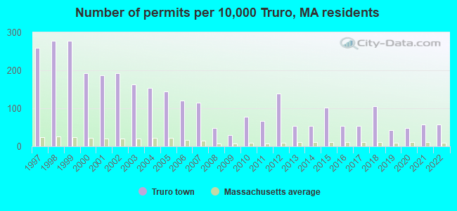
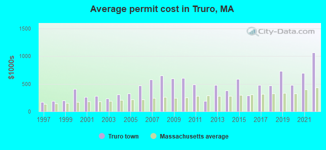
Single-family new house construction building permits:
- 2022: 12 buildings, average cost: $1,064,800
- 2021: 12 buildings, average cost: $695,500
- 2020: 10 buildings, average cost: $480,000
- 2019: 9 buildings, average cost: $729,200
- 2018: 22 buildings, average cost: $465,600
- 2017: 11 buildings, average cost: $475,700
- 2016: 11 buildings, average cost: $293,300
- 2015: 21 buildings, average cost: $585,700
- 2014: 11 buildings, average cost: $381,500
- 2013: 11 buildings, average cost: $481,500
- 2012: 29 buildings, average cost: $187,400
- 2011: 14 buildings, average cost: $488,400
- 2010: 16 buildings, average cost: $600,400
- 2009: 6 buildings, average cost: $592,000
- 2008: 10 buildings, average cost: $646,500
- 2007: 24 buildings, average cost: $578,300
- 2006: 25 buildings, average cost: $467,100
- 2005: 30 buildings, average cost: $327,800
- 2004: 32 buildings, average cost: $308,300
- 2003: 34 buildings, average cost: $235,600
- 2002: 40 buildings, average cost: $279,100
- 2001: 39 buildings, average cost: $262,500
- 2000: 40 buildings, average cost: $407,000
- 1999: 58 buildings, average cost: $199,100
- 1998: 58 buildings, average cost: $189,800
- 1997: 54 buildings, average cost: $170,300
| Here: | 9.9% |
| Massachusetts: | 3.5% |
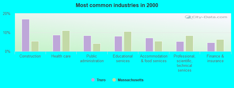
- Construction (17.0%)
- Health care (8.7%)
- Public administration (8.3%)
- Educational services (8.0%)
- Accommodation & food services (7.2%)
- Professional, scientific, technical services (5.2%)
- Finance & insurance (4.7%)
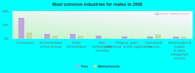
- Construction (30.8%)
- Accommodation & food services (7.5%)
- Public administration (7.5%)
- Arts, entertainment, recreation (4.8%)
- Religious, grantmaking, civic, professional, similar organizations (4.0%)
- Educational services (3.8%)
- Administrative & support & waste management services (3.6%)
- Health care (14.3%)
- Educational services (12.2%)
- Public administration (9.1%)
- Finance & insurance (9.1%)
- Professional, scientific, technical services (7.4%)
- Accommodation & food services (6.8%)
- Real estate & rental & leasing (3.9%)
- Other management occupations, except farmers and farm managers (6.2%)
- Carpenters (5.1%)
- Art and design workers (3.8%)
- Supervisors, construction and extraction workers (3.7%)
- Other sales and related occupations, including supervisors (3.2%)
- Preschool, kindergarten, elementary, and middle school teachers (2.9%)
- Information and record clerks, except customer service representatives (2.7%)
- Carpenters (9.2%)
- Other management occupations, except farmers and farm managers (8.4%)
- Supervisors, construction and extraction workers (6.7%)
- Driver/sales workers and truck drivers (4.0%)
- Art and design workers (4.0%)
- Law enforcement workers, including supervisors (3.8%)
- Building and grounds cleaning and maintenance occupations (3.1%)
- Information and record clerks, except customer service representatives (5.0%)
- Registered nurses (5.0%)
- Other sales and related occupations, including supervisors (4.8%)
- Bookkeeping, accounting, and auditing clerks (4.5%)
- Secretaries and administrative assistants (4.1%)
- Other management occupations, except farmers and farm managers (4.1%)
- Nursing, psychiatric, and home health aides (3.7%)
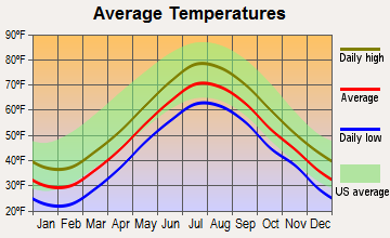
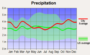
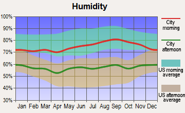
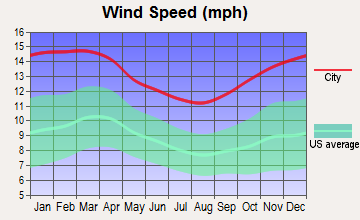
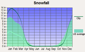
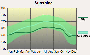
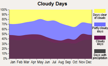
Average climate in Truro, Massachusetts
Based on data reported by over 4,000 weather stations
(lower is better)
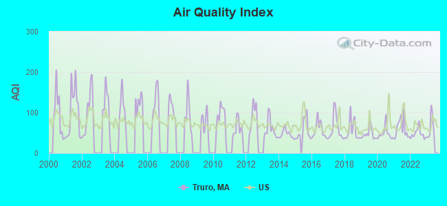
Air Quality Index (AQI) level in 2022 was 48.0. This is significantly better than average.
| City: | 48.0 |
| U.S.: | 72.6 |
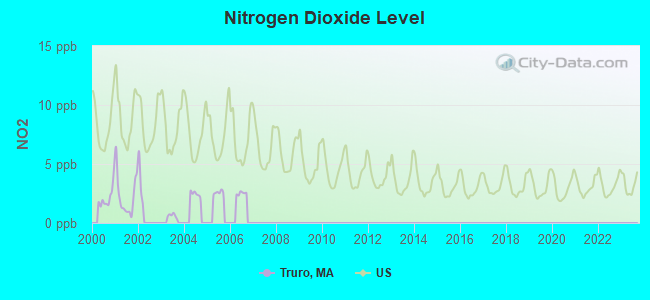
Nitrogen Dioxide (NO2) [ppb] level in 2001 was 2.30. This is significantly better than average. Closest monitor was 3.5 miles away from the city center.
| City: | 2.30 |
| U.S.: | 5.11 |
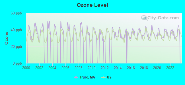
Ozone [ppb] level in 2022 was 34.8. This is about average. Closest monitor was 3.5 miles away from the city center.
| City: | 34.8 |
| U.S.: | 33.3 |
Earthquake activity:
Truro-area historical earthquake activity is significantly above Massachusetts state average. It is 77% smaller than the overall U.S. average.On 10/16/2012 at 23:12:25, a magnitude 4.7 (4.7 ML, Depth: 10.0 mi, Class: Light, Intensity: IV - V) earthquake occurred 113.6 miles away from Truro center
On 1/19/1982 at 00:14:42, a magnitude 4.7 (4.5 MB, 4.7 MD, 4.5 LG) earthquake occurred 129.0 miles away from Truro center
On 4/20/2002 at 10:50:47, a magnitude 5.3 (5.3 ML, Depth: 3.0 mi, Class: Moderate, Intensity: VI - VII) earthquake occurred 251.5 miles away from the city center
On 10/7/1983 at 10:18:46, a magnitude 5.3 (5.1 MB, 5.3 LG, 5.1 ML) earthquake occurred 254.4 miles away from the city center
On 4/20/2002 at 10:50:47, a magnitude 5.2 (5.2 MB, 4.2 MS, 5.2 MW, 5.0 MW) earthquake occurred 251.1 miles away from Truro center
On 8/22/1992 at 12:20:32, a magnitude 4.8 (4.8 MB, 3.8 MS, 4.7 LG, Depth: 6.2 mi) earthquake occurred 201.4 miles away from Truro center
Magnitude types: regional Lg-wave magnitude (LG), body-wave magnitude (MB), duration magnitude (MD), local magnitude (ML), surface-wave magnitude (MS), moment magnitude (MW)
Natural disasters:
The number of natural disasters in Barnstable County (21) is greater than the US average (15).Major Disasters (Presidential) Declared: 11
Emergencies Declared: 8
Causes of natural disasters: Hurricanes: 7, Floods: 5, Storms: 4, Snows: 3, Snowstorms: 3, Winter Storms: 3, Blizzards: 2, Snowfall: 1, Tropical Storm: 1, Wind: 1, Other: 1 (Note: some incidents may be assigned to more than one category).
Colleges/universities with over 2000 students nearest to Truro:
- Cape Cod Community College (about 27 miles; West Barnstable, MA; Full-time enrollment: 2,491)
- Bridgewater State University (about 47 miles; Bridgewater, MA; FT enrollment: 9,802)
- Massasoit Community College (about 48 miles; Brockton, MA; FT enrollment: 5,442)
- Quincy College (about 51 miles; Quincy, MA; FT enrollment: 3,184)
- Stonehill College (about 52 miles; Easton, MA; FT enrollment: 2,563)
- University of Massachusetts-Boston (about 54 miles; Boston, MA; FT enrollment: 12,625)
- Salem State University (about 54 miles; Salem, MA; FT enrollment: 8,027)
Public elementary/middle school in Truro:
- TRURO CENTRAL (Students: 122, Location: 317 ROUTE 6, Grades: PK-6)
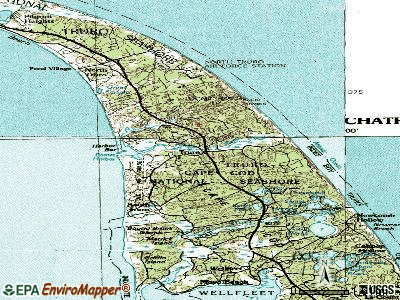
Points of interest:
Notable locations in Truro: Highland Golf Links (A), Highland Light (B), Truro Rescue Squad (C), Truro Fire Department (D), Truro Town Hall (E). Display/hide their locations on the map
Church in Truro: First Church (A). Display/hide its location on the map
Cemeteries: Hill of Churches Hills of Storms (1), Old North Cemetery (2), Snow Cemetery (3), Pine Grove Cemetery (4). Display/hide their locations on the map
Lakes and swamps: Snow Pond (A), Slough Pond (B), Ryder Pond (C), Round Pond (D), Horseleech Pond (E), Great Pond (F), Village Pond (G), Moon Pond (H). Display/hide their locations on the map
River: Pamet River (A). Display/hide its location on the map
Park in Truro: Snows Field (1). Display/hide its location on the map
Beaches: Head of the Meadow Beach (A), Fisher Beach (B). Display/hide their locations on the map
Tourist attractions: Highland Museum & Lighthouse Inc (Cultural Attractions- Events- & Facilities; 27 Highland Light Road) (1), United States Government - Interior Dept- National Park Service- Cape Cod National Seas (Recreation Areas; 32 Old Dewline Road) (2). Display/hide their approximate locations on the map
Hotels: Gingerbread House (Depot Road) (1), Hostelling International Truro (111 North Pamet Road) (2). Display/hide their approximate locations on the map
Birthplace of: Danny MacFayden - Baseball player.
| This town: | 2.0 people |
| Massachusetts: | 2.5 people |
| This town: | 52.9% |
| Whole state: | 63.0% |
| This town: | 12.6% |
| Whole state: | 7.0% |
Likely homosexual households (counted as self-reported same-sex unmarried-partner households)
- Lesbian couples: 3.3% of all households
- Gay men: 3.3% of all households
| This town: | 11.2% |
| Whole state: | 9.3% |
| This town: | 6.3% |
| Whole state: | 4.4% |
People in group quarters in Truro in 2000:
- 71 people in religious group quarters
- 32 people in other workers' dormitories
- 4 people in other nonhousehold living situations
For population 15 years and over in Truro:
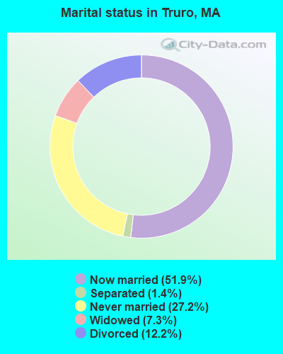
- Never married: 27.2%
- Now married: 51.9%
- Separated: 1.4%
- Widowed: 7.3%
- Divorced: 12.2%
For population 25 years and over in Truro:
- High school or higher: 92.8%
- Bachelor's degree or higher: 40.5%
- Graduate or professional degree: 13.2%
- Unemployed: 13.9%
- Mean travel time to work (commute): 18.1 minutes

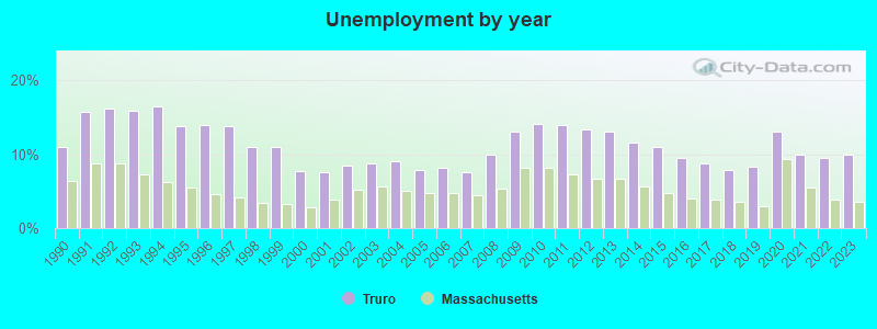
| Here: | 9.5 |
| Massachusetts average: | 13.1 |

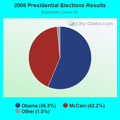

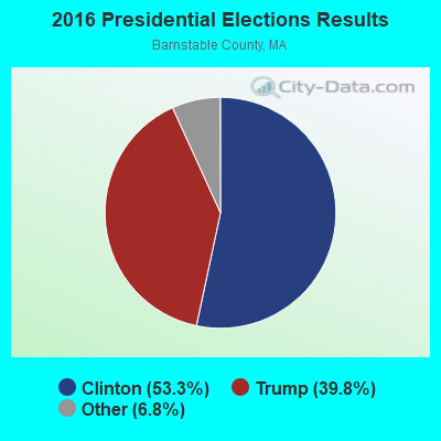
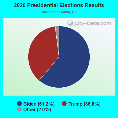
Graphs represent county-level data. Detailed 2008 Election Results
Religion statistics for Truro, MA (based on Barnstable County data)
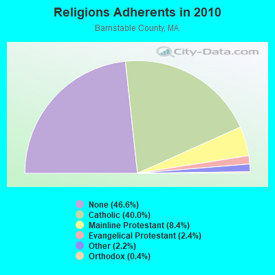
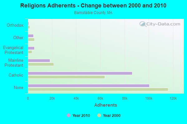
| Religion | Adherents | Congregations |
|---|---|---|
| Catholic | 86,370 | 18 |
| Mainline Protestant | 18,165 | 68 |
| Evangelical Protestant | 5,281 | 46 |
| Other | 4,734 | 32 |
| Orthodox | 810 | 3 |
| None | 100,528 | - |
Food Environment Statistics:
| Barnstable County: | 3.06 / 10,000 pop. |
| State: | 1.98 / 10,000 pop. |
| Here: | 0.05 / 10,000 pop. |
| Massachusetts: | 0.05 / 10,000 pop. |
| Barnstable County: | 3.38 / 10,000 pop. |
| Massachusetts: | 2.22 / 10,000 pop. |
| Barnstable County: | 2.57 / 10,000 pop. |
| Massachusetts: | 1.77 / 10,000 pop. |
| This county: | 18.60 / 10,000 pop. |
| Massachusetts: | 8.76 / 10,000 pop. |
| Barnstable County: | 7.9% |
| State: | 8.1% |
| Barnstable County: | 19.6% |
| Massachusetts: | 22.5% |
| This county: | 13.8% |
| State: | 16.5% |
Strongest AM radio stations in Truro:
- WBZ (1030 AM; 50 kW; BOSTON, MA; Owner: INFINITY BROADCASTING OPERATIONS, INC.)
- WRKO (680 AM; 50 kW; BOSTON, MA; Owner: ENTERCOM BOSTON LICENSE, LLC)
- WEEI (850 AM; 50 kW; BOSTON, MA; Owner: ENTERCOM BOSTON LICENSE, LLC)
- WWZN (1510 AM; 50 kW; BOSTON, MA; Owner: ROSE CITY RADIO CORPORATION)
- WALE (990 AM; 50 kW; GREENVILLE, RI; Owner: NORTH AMERICAN BROADCASTING CO., INC.)
- WKOX (1200 AM; 50 kW; FRAMINGHAM, MA; Owner: CAPSTAR TX LIMITED PARTNERSHIP)
- WBIX (1060 AM; 40 kW; NATICK, MA; Owner: LANGER BROADCASTING CORPORATION)
- WCRN (830 AM; 50 kW; WORCESTER, MA; Owner: CARTER BROADCASTING CORPORATION)
- WAMG (890 AM; 25 kW; DEDHAM, MA; Owner: MEGA COMMUNICATIONS OF DEDHAM LICENSEE, LLC)
- WRCA (1330 AM; 25 kW; WALTHAM, MA; Owner: WRCA LICENSE, LLC)
- WNNZ (640 AM; 50 kW; WESTFIELD, MA; Owner: CLEAR CHANNEL BROADCASTING LICENSES, INC.)
- WUNR (1600 AM; 20 kW; BROOKLINE, MA; Owner: CHAMPION BROADCASTING SYSTEMS, INC.)
- WPLM (1390 AM; 5 kW; PLYMOUTH, MA; Owner: PLYMOUTH ROCK BROADCASTING CO., INC.)
Strongest FM radio stations in Truro:
- WCDJ (102.3 FM; TRURO, MA; Owner: TRURO WIRELESS, INC.)
- WOMR (92.1 FM; PROVINCETOWN, MA; Owner: LOWER CAPE COMMUNICATIONS, INC.)
- WKPE-FM (104.7 FM; ORLEANS, MA; Owner: CRB WKPE LIC CORP.)
- WCOD-FM (106.1 FM; HYANNIS, MA; Owner: BOCH BROADCASTING, L.P.)
- WFCC-FM (107.5 FM; CHATHAM, MA; Owner: CHARLES RIVER B/CING WFCC LIC. CORP.)
- WDVT (93.5 FM; HARWICH PORT, MA; Owner: BOCH BROADCASTING, L.P.)
- WPXC (102.9 FM; HYANNIS, MA; Owner: QANTUM OF CAPE COD LICENSE COMPANY, LLC)
- WOCN-FM (103.9 FM; SOUTH YARMOUTH, MA; Owner: SANDAB COMMUNICATIONS LTD. PARTNERSHIP II)
- WQRC (99.9 FM; BARNSTABLE, MA; Owner: SANDAB COMMUNICATION LTD. PNR/SHP II)
- WXTK (95.1 FM; WEST YARMOUTH, MA; Owner: BOCH BROADCASTING LTD. PARTNERSHIP)
TV broadcast stations around Truro:
- WDPX (Channel 58; VINEYARD HAVEN, MA; Owner: PAXSON BOSTON-68 LICENSE, INC.)
- W08CH (Channel 8; HYANNIS, MA; Owner: WGBH EDUCATIONAL FOUNDATION)
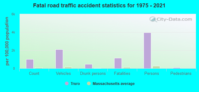
- National Bridge Inventory (NBI) Statistics
- 2Number of bridges
- 26ft / 7.5mTotal length
- $8,824,000Total costs
- 31,977Total average daily traffic
- 1,744Total average daily truck traffic
- 50,222Total future (year 2032) average daily traffic
FCC Registered Cell Phone Towers:
2- 344 Route 6 (76809) (Lat: 42.021889 Lon: -70.074861), Type: Ltower, Structure height: 52.1 m, Overall height: 53 m, Call Sign: KNKN705
Assigned Frequencies: 869.040 MHz, 869.040 MHz, 869.040 MHz, 824.040 MHz, 824.040 MHz, 824.040 MHz, 890.010 MHz, 890.010 MHz, 890.010 MHz, 845.010 MHz, 845.010 MHz, 845.010 MHzGrant Date: 09/01/2020, Expiration Date: 10/01/2030, Certifier: Michael P GogginRegistrant: At&t Services, Inc., 208 S Akard St, 20f, Dallas, TX 75202, Phone: (855) 699-7073, Fax: (214) 746-6410, Email:
- 344 Route 6 North (Lat: 42.021944 Lon: -70.075000), Type: Tower, Structure height: 54.9 m, Call Sign: KNKN826
Assigned Frequencies: 880.020 MHz, 880.020 MHz, 880.020 MHz, 835.020 MHz, 835.020 MHz, 835.020 MHz, 891.510 MHz, 891.510 MHz, 891.510 MHz, 846.510 MHz, 846.510 MHz, 846.510 MHzGrant Date: 09/01/2020, Expiration Date: 10/01/2030Registrant: Verizon Wireless, 5055 North Point Pkwy, Np2ne Network Engineering, Alpharetta, GA 30022, Phone: (770) 797-1070, Fax: (770) 797-1036, Email:
FCC Registered Broadcast Land Mobile Towers:
2- Town Hall (Lat: 41.998167 Lon: -70.056417), Call Sign: KDA700,
Assigned Frequencies: 155.520 MHz, 155.565 MHz, 155.640 MHz, 155.700 MHz, 158.850 MHz, Grant Date: 08/26/2021, Expiration Date: 11/20/2031, Registrant: Barnstable County Sheriff\'s Office, 6000 Sheriff\'s Place, Bourne, MA 02532, Phone: (508) 563-4210, Fax: (508) 563-4288, Email:
- Lat: 42.016583 Lon: -70.071167, Call Sign: WQDK259,
Assigned Frequencies: 72.1000 MHz, Grant Date: 08/19/2015, Expiration Date: 09/15/2025, Certifier: Brian Davis, Registrant: Truro School District, 317 Route 6, Truro, MA 02666, Phone: (508) 487-1558, Fax: (508) 487-4289, Email:
FCC Registered Microwave Towers:
3- TRURO, 1000 Route 6 (Lat: 42.021667 Lon: -70.075000), Type: Mast, Structure height: 52.1 m, Overall height: 53 m, Call Sign: WMT396,
Assigned Frequencies: 6165.10 MHz, Grant Date: 02/23/2011, Expiration Date: 02/01/2021, Cancellation Date: 08/07/2014, Certifier: Carol L Tacker, Registrant: At&t Mobility LLC, 1120 20th Street, Nw - Suite 1000, Washington, DC 20036, Phone: (202) 457-2055, Fax: (202) 457-3073, Email:
- Truro Police Tower, 344 Route 6 (Lat: 42.022083 Lon: -70.074667), Type: Ltower, Structure height: 48.8 m, Call Sign: WQPX472,
Assigned Frequencies: 11225.0 MHz, 11265.0 MHz, 11425.0 MHz, 11465.0 MHz, 11225.0 MHz, 11265.0 MHz, 11425.0 MHz, 11465.0 MHz, 11225.0 MHz, 11265.0 MHz... (+38 more), Grant Date: 09/10/2012, Expiration Date: 09/10/2022, Cancellation Date: 11/12/2022, Certifier: Dan Gallagher, Registrant: Radyn, Inc, Silver Spring, MD 20914, Phone: (301) 493-5171, Fax: (301) 576-4553, Email:
- Truro Police Tower, 344 Route 6 (Lat: 42.022083 Lon: -70.074667), Type: Ltower, Structure height: 48.8 m, Call Sign: WRXN849, Licensee ID: L01721556,
Assigned Frequencies: 11225.0 MHz, 11265.0 MHz, 11425.0 MHz, 11465.0 MHz, 11225.0 MHz, 11265.0 MHz, 11425.0 MHz, 11465.0 MHz, 11225.0 MHz, 11265.0 MHz... (+38 more), Grant Date: 06/05/2023, Expiration Date: 06/05/2033, Certifier: Jennifer Brann, Registrant: Opencape Corporation, 3195 Main Street, Barnstable, MA 02630, Phone: (508) 362-2224, Fax: (508) 362-0454, Email:
FCC Registered Maritime Coast & Aviation Ground Towers:
1- High Ridge Rd (Lat: 42.000111 Lon: -70.082806), Type: Building, Overall height: 7 m, Call Sign: KXS388, Licensee ID: L00002799,
Assigned Frequencies: 156.425 MHz, 156.450 MHz, 156.800 MHz, Grant Date: 06/19/2002, Expiration Date: 07/28/2012, Cancellation Date: 09/29/2012, Registrant: Intrepid Tuna Company, High Ridge Rd, Truro, MA 02666
FCC Registered Amateur Radio Licenses:
9 (See the full list of FCC Registered Amateur Radio Licenses in Truro)2002 - 2018 National Fire Incident Reporting System (NFIRS) incidents
- Fire incident types reported to NFIRS in Truro, MA
- 7363.5%Structure Fires
- 2219.1%Outside Fires
- 1210.4%Other
- 87.0%Mobile Property/Vehicle Fires
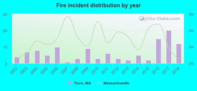 According to the data from the years 2002 - 2018 the average number of fires per year is 7. The highest number of reported fires - 20 took place in 2017, and the least - 1 in 2007. The data has a growing trend.
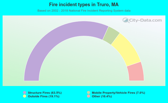 When looking into fire subcategories, the most incidents belonged to: Structure Fires (63.5%), and Outside Fires (19.1%).
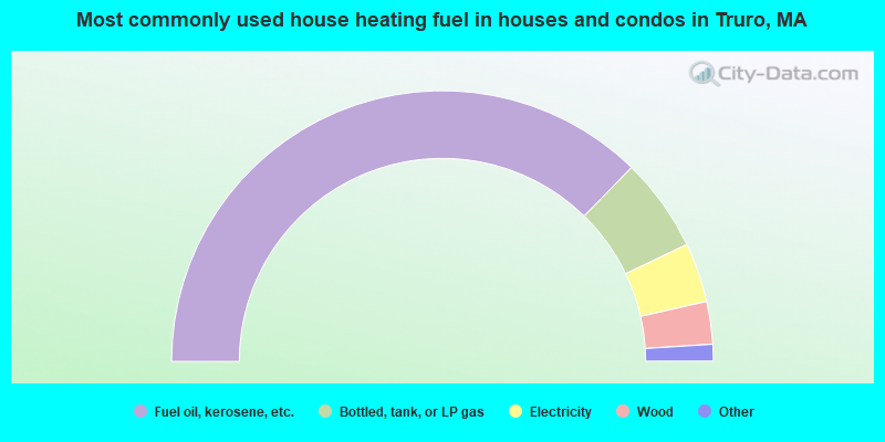
- 74.6%Fuel oil, kerosene, etc.
- 11.2%Bottled, tank, or LP gas
- 7.1%Electricity
- 5.1%Wood
- 1.4%Coal or coke
- 0.3%Utility gas
- 0.3%Other fuel

- 58.9%Fuel oil, kerosene, etc.
- 26.2%Bottled, tank, or LP gas
- 8.9%Electricity
- 5.0%Wood
- 1.0%Utility gas
Truro compared to Massachusetts state average:
- Median house value above state average.
- Black race population percentage significantly below state average.
- Hispanic race population percentage significantly below state average.
- Median age significantly above state average.
- Foreign-born population percentage significantly below state average.
- Renting percentage below state average.
- Length of stay since moving in significantly above state average.
- Number of rooms per house significantly below state average.
- House age significantly below state average.
- Number of college students below state average.
Truro on our top lists:
- #13 on the list of "Top 101 cities with the largest percentage of people in religious group quarters (population 1,000+)"
- #26 on the list of "Top 101 cities with the largest percentage of people in other workers' dormitories (population 1,000+)"
- #1 on the list of "Top 101 counties with the highest percentage of residents that smoked 100+ cigarettes in their lives"
- #7 on the list of "Top 101 counties with the lowest number of births per 1000 residents 2007-2013"
- #9 on the list of "Top 101 counties with the highest percentage of residents that visited a dentist within the past year"
- #10 on the list of "Top 101 counties with the lowest average weight of females"
- #24 on the list of "Top 101 counties with the largest number of people without health insurance coverage in 2000 (pop. 50,000+)"

|
Total of 5 patent applications in 2008-2024.