Union Vale, New York
Submit your own pictures of this town and show them to the world
- OSM Map
- Google Map
- MSN Map
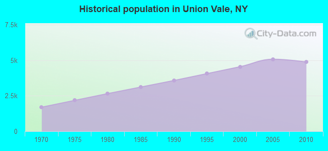
Population change since 2000: +7.3%
 |
| Males: 2,416 | |
| Females: 2,461 |
| Median resident age: | 43.6 years |
| New York median age: | 40.7 years |
Zip codes: 12545.
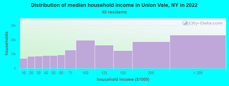
| Union Vale: | $120,704 |
| NY: | $79,557 |
Estimated per capita income in 2022: $50,728 (it was $24,535 in 2000)
Union Vale town income, earnings, and wages data
Estimated median house or condo value in 2022: $478,193 (it was $192,400 in 2000)
| Union Vale: | $478,193 |
| NY: | $400,400 |
Mean prices in 2022: all housing units: $414,214; detached houses: $452,020; townhouses or other attached units: $307,694; in 2-unit structures: $268,927; in 3-to-4-unit structures: $222,482; in 5-or-more-unit structures: $275,815; mobile homes: $90,593
Detailed information about poverty and poor residents in Union Vale, NY
Compare current foreclosures near Union Vale, NY:
| Photo | Address | Area | Beds / Baths | Price | Details |
|---|---|---|---|---|---|

|
#1
Tinkertown Rd
Pleasant Valley, NY 12569
|
2,970 sq. feet
|
2 baths 3 beds |
$493,395
|
show details |

|
#2
Dorothy Hts
Wappingers Falls, NY 12590
|
1,113 sq. feet
|
1 baths 3 beds |
$389,900
|
show details |

|
#3
Church St
Poughkeepsie, NY 12601
|
1,521 sq. feet
|
1 baths 4 beds |
$25,000
|
show details |

|
#4
Penny Ln
Marlboro, NY 12542
|
2,514 sq. feet
|
2 baths 3 beds |
$299,900
|
show details |

|
#5
Salt Point Tpke
Clinton Corners, NY 12514
|
1,148 sq. feet
|
1 baths 3 beds |
$254,900
|
show details |

|
#6
Lyons Ln
Milton, NY 12547
|
1,872 sq. feet
|
2 baths 3 beds |
$34,900
|
show details |

|
#7
Dunham Ct
Hopewell Junction, NY 12533
|
3,151 sq. feet
|
2 baths 4 beds |
show details | |

|
#8
Carmine Dr C-8
Wappingers Falls, NY 12590
|
1,064 sq. feet
|
2 baths 2 beds |
show details | |

|
#9
Grape Hollow Rd
Holmes, NY 12531
|
3,972 sq. feet
|
3 baths 6 beds |
show details | |

|
#10
Gray St
Poughkeepsie, NY 12603
|
2,880 sq. feet
|
2 baths 4 beds |
show details |
| Photo | Address | Area | Beds / Baths | Price | Details |
|---|---|---|---|---|---|

|
#11
Cooper Rd
Fishkill, NY 12524
|
1,346 sq. feet
|
2 baths 2 beds |
show details | |

|
#12
S Quaker Ln
Hyde Park, NY 12538
|
1,300 sq. feet
|
2 baths 3 beds |
show details | |

|
#13
Echo Rd
Carmel, NY 10512
|
1,368 sq. feet
|
1 baths 3 beds |
show details | |

|
#14
Cardinal Rd
Hyde Park, NY 12538
|
2,692 sq. feet
|
2 baths 3 beds |
show details | |

|
#15
Deer Ln
Hopewell Junction, NY 12533
|
1,676 sq. feet
|
2 baths 4 beds |
show details | |

|
#16
Purse Ln # 12533
Hopewell Junction, NY 12533
|
910 sq. feet
|
1 baths 2 beds |
show details | |

|
#17
Pine Hill Rd
Pleasant Valley, NY 12569
|
2,000 sq. feet
|
3 baths 3 beds |
show details | |

|
#18
Chestnut Ridge Rd
Dover Plains, NY 12522
|
1,002 sq. feet
|
1 baths 2 beds |
show details | |

|
#19
Route 376
Wappingers Falls, NY 12590
|
1,894 sq. feet
|
1 baths 3 beds |
show details | |

|
#20
Ferrara Dr
Rhinebeck, NY 12572
|
1,530 sq. feet
|
2 baths 3 beds |
show details |
| Photo | Address | Area | Beds / Baths | Price | Details |
|---|---|---|---|---|---|

|
#21
Hamilton Rd
Hopewell Junction, NY 12533
|
2,468 sq. feet
|
3 baths 4 beds |
show details | |

|
#22
Fenton Way
Hopewell Junction, NY 12533
|
3,227 sq. feet
|
4 baths 4 beds |
show details | |

|
#23
All Angels Hill Rd
Wappingers Falls, NY 12590
|
1,196 sq. feet
|
2 baths 3 beds |
show details | |

|
#24
Doolin Ct
Wappingers Falls, NY 12590
|
3,332 sq. feet
|
3 baths 4 beds |
show details | |

|
#25
Quaker Hill Dr
Hyde Park, NY 12538
|
1,003 sq. feet
|
1 baths 3 beds |
show details | |

|
#26
S Smith Rd
Lagrangeville, NY 12540
|
2,128 sq. feet
|
2 baths 3 beds |
show details | |

|
#27
N Bridge St
Poughkeepsie, NY 12601
|
1,613 sq. feet
|
2 baths 2 beds |
show details | |

|
#28
Hill And Hollow Rd
Hyde Park, NY 12538
|
2,787 sq. feet
|
3 baths 5 beds |
show details | |

|
#29
Woodcliff Dr
Stormville, NY 12582
|
2,500 sq. feet
|
2 baths 4 beds |
show details | |

|
#30
Wildwood Dr Apt 3a
Wappingers Falls, NY 12590
|
840 sq. feet
|
1 baths 2 beds |
show details |
| Photo | Address | Area | Beds / Baths | Price | Details |
|---|---|---|---|---|---|

|
#31
South Rd
Holmes, NY 12531
|
971 sq. feet
|
1 baths 3 beds |
show details | |

|
#32
Parker Ave
Poughkeepsie, NY 12601
|
3,648 sq. feet
|
2 baths 9 beds |
show details | |

|
#33
Marshall St
Poughkeepsie, NY 12601
|
2,656 sq. feet
|
2 baths 5 beds |
show details | |

|
#34
Sachson Pl
Wappingers Falls, NY 12590
|
1,758 sq. feet
|
1 baths 3 beds |
show details | |

|
#35
Kent Rd
Wappingers Falls, NY 12590
|
1,340 sq. feet
|
1 baths 3 beds |
show details | |

|
#36
Lakeside Dr
Wappingers Falls, NY 12590
|
1,056 sq. feet
|
1 baths 2 beds |
show details | |

|
#37
Circle Dr
Hopewell Junction, NY 12533
|
2,640 sq. feet
|
2 baths 4 beds |
show details | |

|
#38
Lenny Ct
Wappingers Falls, NY 12590
|
1,758 sq. feet
|
1 baths 3 beds |
show details | |

|
#39
Lenny Ct
Wappingers Falls, NY 12590
|
1,758 sq. feet
|
1 baths 3 beds |
show details | |

|
#40
Marino Rd
Poughkeepsie, NY 12601
|
1,512 sq. feet
|
1 baths 4 beds |
show details |
| Photo | Address | Area | Beds / Baths | Price | Details |
|---|---|---|---|---|---|

|
#41
Route 44
Amenia, NY 12501
|
2,016 sq. feet
|
2 baths 3 beds |
show details | |

|
#42
Tall Tree Ln
Poughkeepsie, NY 12601
|
1,210 sq. feet
|
1 baths 2 beds |
show details | |

|
#43
Marie Ct
Poughkeepsie, NY 12601
|
2,900 sq. feet
|
3 baths 4 beds |
show details | |

|
#44
Fieldstone Blvd
Wappingers Falls, NY 12590
|
2,249 sq. feet
|
1 baths 3 beds |
show details | |

|
#45
Windsor Ct
Poughkeepsie, NY 12601
|
1,584 sq. feet
|
2 baths 2 beds |
show details | |

|
#46
Meadowbrook Lane
Staatsburg, NY 12580
|
2,018 sq. feet
|
2 baths 3 beds |
show details | |

|
#47
Cardinal Dr
Poughkeepsie, NY 12601
|
1,080 sq. feet
|
1 baths 3 beds |
show details | |

|
#48
Blackthorn Loop
Wappingers Falls, NY 12590
|
1,542 sq. feet
|
1 baths 3 beds |
show details | |

|
#49
Matuk Dr
Hyde Park, NY 12538
|
1,522 sq. feet
|
1 baths 3 beds |
show details | |

|
Check over 1 million property listings on Foreclosure.com!
|
browse all offers | |||

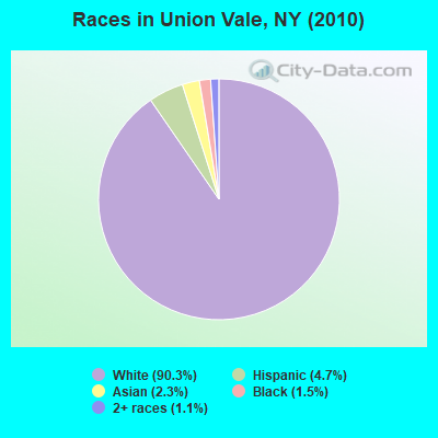
- 4,40690.3%White alone
- 2274.7%Hispanic
- 1102.3%Asian alone
- 741.5%Black alone
- 561.1%Two or more races
- 40.08%Other race alone
Races in Union Vale detailed stats: ancestries, foreign born residents, place of birth
 Recent articles from our blog. Our writers, many of them Ph.D. graduates or candidates, create easy-to-read articles on a wide variety of topics.

Ancestries: Italian (32.1%), Irish (31.3%), German (20.9%), English (9.1%), Polish (5.2%), Dutch (2.5%).
Current Local Time: EST time zone
Land area: 37.7 square miles.
Population density: 129 people per square mile (very low).
264 residents are foreign born (3.5% Europe, 1.1% Latin America, 1.1% Asia).
| This town: | 5.8% |
| New York: | 20.4% |
| Union Vale town: | 1.8% ($3,525) |
| New York: | 1.9% ($2,847) |
Nearest city with pop. 50,000+: Danbury, CT  (23.8 miles , pop. 74,848).
Nearest city with pop. 200,000+: Bronx, NY (59.6 miles , pop. 1,332,650).
Nearest cities:
), ), ), ), )Latitude: 41.70 N, Longitude: 73.70 W
Area code commonly used in this area: 845
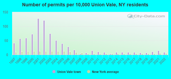
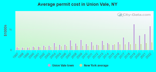
Single-family new house construction building permits:
- 2022: 4 buildings, average cost: $1,175,000
- 2021: 7 buildings, average cost: $785,700
- 2020: 5 buildings, average cost: $720,000
- 2019: 3 buildings, average cost: $1,266,700
- 2018: 3 buildings, average cost: $400,000
- 2017: 4 buildings, average cost: $625,000
- 2016: 4 buildings, average cost: $397,100
- 2015: 4 buildings, average cost: $257,200
- 2014: 4 buildings, average cost: $350,000
- 2013: 2 buildings, average cost: $462,500
- 2012: 4 buildings, average cost: $265,000
- 2011: 5 buildings, average cost: $400,000
- 2010: 7 buildings, average cost: $300,000
- 2009: 3 buildings, average cost: $500,000
- 2008: 2 buildings, average cost: $325,000
- 2007: 8 buildings, average cost: $475,000
- 2006: 13 buildings, average cost: $275,000
- 2005: 18 buildings, average cost: $275,000
- 2004: 23 buildings, average cost: $348,000
- 2003: 34 buildings, average cost: $223,500
- 2002: 55 buildings, average cost: $224,900
- 2001: 58 buildings, average cost: $175,900
- 2000: 33 buildings, average cost: $179,500
- 1999: 27 buildings, average cost: $126,400
- 1998: 26 buildings, average cost: $124,300
- 1997: 19 buildings, average cost: $139,000
| Here: | 3.6% |
| New York: | 4.4% |

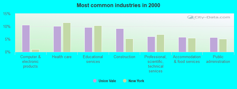
- Computer & electronic products (10.6%)
- Health care (10.1%)
- Educational services (9.6%)
- Construction (9.2%)
- Professional, scientific, technical services (6.0%)
- Accommodation & food services (5.8%)
- Public administration (5.7%)
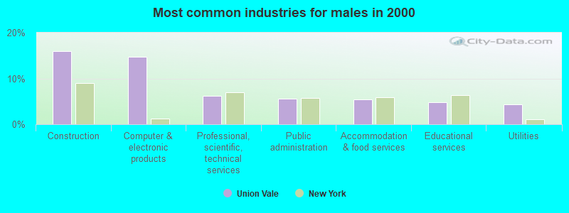
- Construction (15.9%)
- Computer & electronic products (14.8%)
- Professional, scientific, technical services (6.2%)
- Public administration (5.6%)
- Accommodation & food services (5.4%)
- Educational services (4.8%)
- Utilities (4.3%)
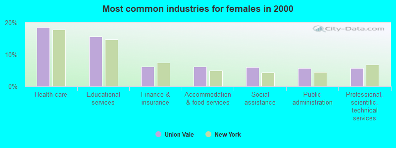
- Health care (18.7%)
- Educational services (15.6%)
- Finance & insurance (6.2%)
- Accommodation & food services (6.2%)
- Social assistance (6.0%)
- Public administration (5.8%)
- Professional, scientific, technical services (5.8%)
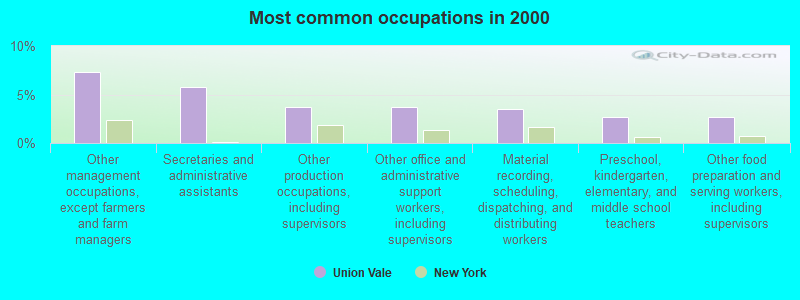
- Other management occupations, except farmers and farm managers (7.3%)
- Secretaries and administrative assistants (5.8%)
- Other production occupations, including supervisors (3.7%)
- Other office and administrative support workers, including supervisors (3.7%)
- Material recording, scheduling, dispatching, and distributing workers (3.5%)
- Preschool, kindergarten, elementary, and middle school teachers (2.7%)
- Other food preparation and serving workers, including supervisors (2.7%)
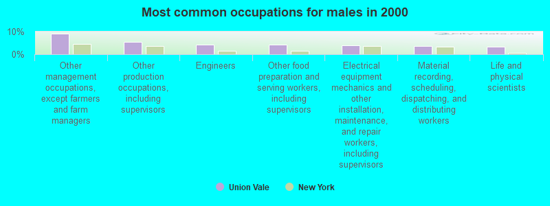
- Other management occupations, except farmers and farm managers (9.1%)
- Other production occupations, including supervisors (5.4%)
- Engineers (4.3%)
- Other food preparation and serving workers, including supervisors (4.1%)
- Electrical equipment mechanics and other installation, maintenance, and repair workers, including supervisors (3.9%)
- Material recording, scheduling, dispatching, and distributing workers (3.8%)
- Life and physical scientists (3.4%)
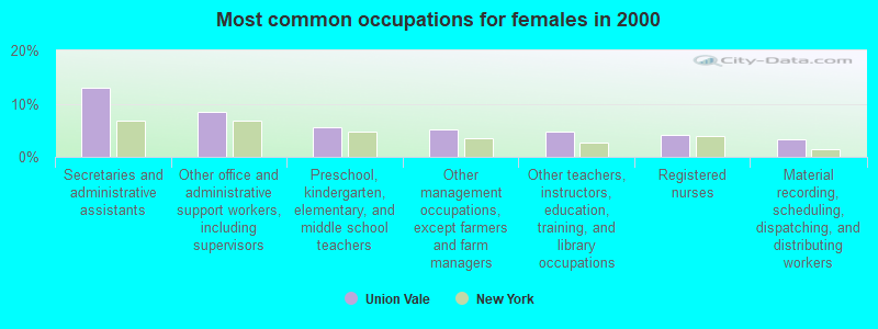
- Secretaries and administrative assistants (12.9%)
- Other office and administrative support workers, including supervisors (8.4%)
- Preschool, kindergarten, elementary, and middle school teachers (5.5%)
- Other management occupations, except farmers and farm managers (5.2%)
- Other teachers, instructors, education, training, and library occupations (4.6%)
- Registered nurses (4.0%)
- Material recording, scheduling, dispatching, and distributing workers (3.2%)
Average climate in Union Vale, New York
Based on data reported by over 4,000 weather stations


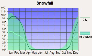


(lower is better)
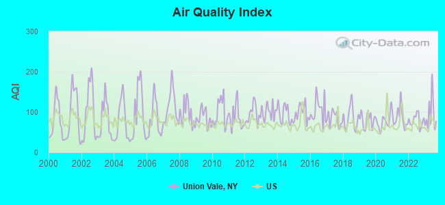
Air Quality Index (AQI) level in 2023 was 94.0. This is worse than average.
| City: | 94.0 |
| U.S.: | 72.6 |
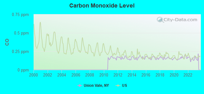
Carbon Monoxide (CO) [ppm] level in 2022 was 0.149. This is significantly better than average. Closest monitor was 12.2 miles away from the city center.
| City: | 0.149 |
| U.S.: | 0.251 |
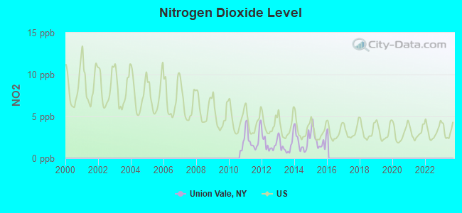
Nitrogen Dioxide (NO2) [ppb] level in 2015 was 2.27. This is significantly better than average. Closest monitor was 6.4 miles away from the city center.
| City: | 2.27 |
| U.S.: | 5.11 |
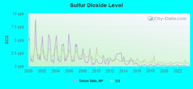
Sulfur Dioxide (SO2) [ppb] level in 2022 was 0.109. This is significantly better than average. Closest monitor was 5.0 miles away from the city center.
| City: | 0.109 |
| U.S.: | 1.515 |
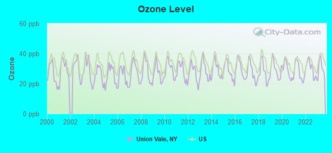
Ozone [ppb] level in 2023 was 30.4. This is about average. Closest monitor was 6.4 miles away from the city center.
| City: | 30.4 |
| U.S.: | 33.3 |
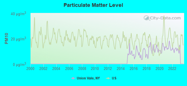
Particulate Matter (PM10) [µg/m3] level in 2022 was 11.4. This is significantly better than average. Closest monitor was 16.8 miles away from the city center.
| City: | 11.4 |
| U.S.: | 19.2 |
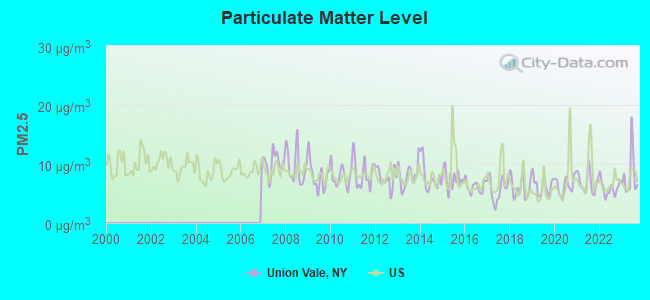
Particulate Matter (PM2.5) [µg/m3] level in 2023 was 8.07. This is about average. Closest monitor was 11.1 miles away from the city center.
| City: | 8.07 |
| U.S.: | 8.11 |
Tornado activity:
Union Vale-area historical tornado activity is above New York state average. It is 27% smaller than the overall U.S. average.
On 5/29/1995, a category F4 (max. wind speeds 207-260 mph) tornado 37.4 miles away from the Union Vale town center killed 3 people and injured 24 people and caused between $5,000,000 and $50,000,000 in damages.
On 8/28/1973, a category F4 tornado 42.8 miles away from the town center killed 4 people and injured 36 people and caused between $5,000,000 and $50,000,000 in damages.
Earthquake activity:
Union Vale-area historical earthquake activity is significantly above New York state average. It is 68% smaller than the overall U.S. average.On 10/7/1983 at 10:18:46, a magnitude 5.3 (5.1 MB, 5.3 LG, 5.1 ML, Class: Moderate, Intensity: VI - VII) earthquake occurred 159.3 miles away from Union Vale center
On 4/20/2002 at 10:50:47, a magnitude 5.3 (5.3 ML, Depth: 3.0 mi) earthquake occurred 194.7 miles away from Union Vale center
On 4/20/2002 at 10:50:47, a magnitude 5.2 (5.2 MB, 4.2 MS, 5.2 MW, 5.0 MW) earthquake occurred 192.9 miles away from Union Vale center
On 8/23/2011 at 17:51:04, a magnitude 5.8 (5.8 MW, Depth: 3.7 mi) earthquake occurred 345.4 miles away from the city center
On 1/19/1982 at 00:14:42, a magnitude 4.7 (4.5 MB, 4.7 MD, 4.5 LG, Class: Light, Intensity: IV - V) earthquake occurred 164.2 miles away from Union Vale center
On 1/16/1994 at 01:49:16, a magnitude 4.6 (4.6 MB, 4.6 LG, Depth: 3.1 mi) earthquake occurred 154.4 miles away from Union Vale center
Magnitude types: regional Lg-wave magnitude (LG), body-wave magnitude (MB), duration magnitude (MD), local magnitude (ML), surface-wave magnitude (MS), moment magnitude (MW)
Natural disasters:
The number of natural disasters in Dutchess County (19) is greater than the US average (15).Major Disasters (Presidential) Declared: 12
Emergencies Declared: 6
Causes of natural disasters: Storms: 5, Floods: 4, Hurricanes: 4, Blizzards: 2, Snowstorms: 2, Winter Storms: 2, Power Outage: 1, Water Shortage: 1, Other: 3 (Note: some incidents may be assigned to more than one category).
Hospitals and medical centers near Union Vale:
- NEW HORIZONS RESOURCES, INC. (Hospital, about 6 miles away; PLEASANT VALLEY, NY)
- LIFESPIRE, INC (Hospital, about 8 miles away; WOODSIDE, NY)
- LUTHERAN CENTER AT POUGHKEEPSIE INC (Nursing Home, about 8 miles away; POUGHKEEPSIE, NY)
- CARDINAL HAYES HOME FOR CHILDREN, INC (Hospital, about 9 miles away; PLEASANT VALLEY, NY)
- TACONIC DDSO (Hospital, about 10 miles away; WASSAIC, NY)
- DUTCHESS CENTER FOR REHAB AND HEALTHCARE (Nursing Home, about 11 miles away; PAWLING, NY)
- VICTORY LAKE NURSING CENTER (Nursing Home, about 11 miles away; HYDE PARK, NY)
Colleges/universities with over 2000 students nearest to Union Vale:
- Vassar College (about 11 miles; Poughkeepsie, NY; Full-time enrollment: 2,469)
- Dutchess Community College (about 11 miles; Poughkeepsie, NY; FT enrollment: 6,554)
- Marist College (about 13 miles; Poughkeepsie, NY; FT enrollment: 5,536)
- Culinary Institute of America (about 13 miles; Hyde Park, NY; FT enrollment: 3,869)
- State University of New York at New Paltz (about 21 miles; New Paltz, NY; FT enrollment: 7,319)
- Mount Saint Mary College (about 21 miles; Newburgh, NY; FT enrollment: 2,166)
- Western Connecticut State University (about 25 miles; Danbury, CT; FT enrollment: 5,345)
Points of interest:
Notable locations in Union Vale: Hope Farm (A), The Links at Union Vale (B), Crouses Store (C), Camp Barbey (D), Crazy Acres Farm (E), Unionvale Town Offices (F), Union Vale Fire Department (G), Union Vale Fire Company Station 2 (H). Display/hide their locations on the map
Churches in Union Vale include: Clove Valley Alliance Church (A), Valley Bible Fellowship Church (B), John 316 Christian Center (C), Verbank Methodist Church (D), Oswego Church (E). Display/hide their locations on the map
Cemetery: Clove Cemetery (1). Display/hide its location on the map
Lakes and reservoirs: Norris Pond (A), Sprout Lake (B), Christie Pond (C), Furnace Pond (D), Pray Pond (E), McKinney Pond (F). Display/hide their locations on the map
Streams, rivers, and creeks: Willow Brook (A), Clove Brook (B), Seeley Creek (C), Sweezy Creek (D). Display/hide their locations on the map
Parks in Union Vale include: Godfrey Park (1), Tymore Park (2). Display/hide their locations on the map
| This town: | 2.8 people |
| New York: | 2.6 people |
| This town: | 78.3% |
| Whole state: | 63.5% |
| This town: | 3.0% |
| Whole state: | 6.8% |
Likely homosexual households (counted as self-reported same-sex unmarried-partner households)
- Lesbian couples: 0.2% of all households
- Gay men: 0.2% of all households
| This town: | 2.9% |
| Whole state: | 14.6% |
| This town: | 2.4% |
| Whole state: | 7.4% |
12 people in residential treatment centers for adults in 2010
335 people in homes for the mentally retarded in 2000
For population 15 years and over in Union Vale:
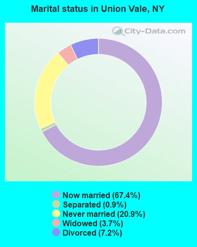
- Never married: 20.9%
- Now married: 67.4%
- Separated: 0.9%
- Widowed: 3.7%
- Divorced: 7.2%
For population 25 years and over in Union Vale:
- High school or higher: 83.1%
- Bachelor's degree or higher: 29.7%
- Graduate or professional degree: 13.1%
- Unemployed: 2.1%
- Mean travel time to work (commute): 33.2 minutes
| Here: | 18.3 |
| New York average: | 14.2 |
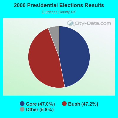
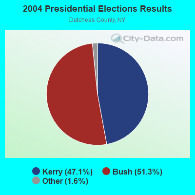
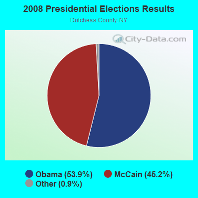
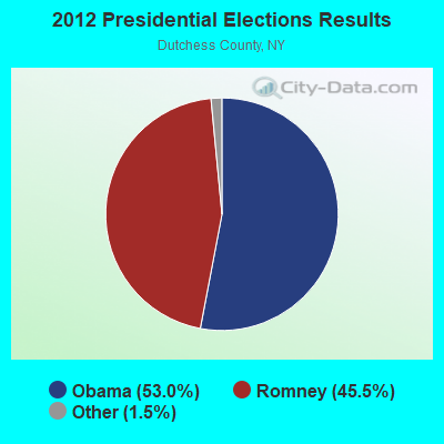
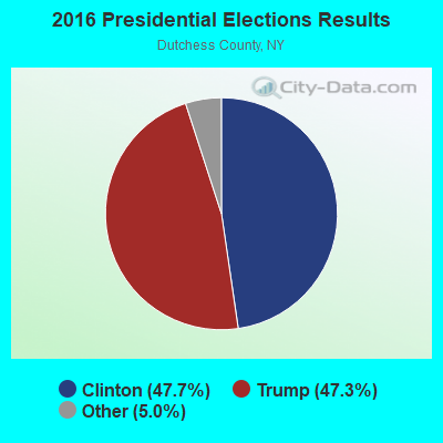

Graphs represent county-level data. Detailed 2008 Election Results
Religion statistics for Union Vale, NY (based on Dutchess County data)
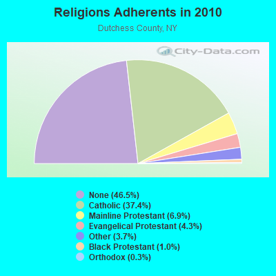
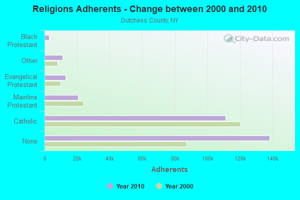
| Religion | Adherents | Congregations |
|---|---|---|
| Catholic | 111,112 | 22 |
| Mainline Protestant | 20,556 | 87 |
| Evangelical Protestant | 12,799 | 69 |
| Other | 10,970 | 28 |
| Black Protestant | 2,898 | 11 |
| Orthodox | 854 | 5 |
| None | 138,299 | - |
Food Environment Statistics:
| Dutchess County: | 3.42 / 10,000 pop. |
| New York: | 4.13 / 10,000 pop. |
| Dutchess County: | 0.10 / 10,000 pop. |
| New York: | 0.06 / 10,000 pop. |
| Dutchess County: | 1.16 / 10,000 pop. |
| State: | 0.92 / 10,000 pop. |
| This county: | 2.63 / 10,000 pop. |
| New York: | 1.68 / 10,000 pop. |
| Dutchess County: | 10.33 / 10,000 pop. |
| State: | 8.82 / 10,000 pop. |
| Dutchess County: | 8.1% |
| State: | 8.2% |
| Here: | 24.4% |
| New York: | 23.8% |
| Dutchess County: | 13.4% |
| New York: | 15.6% |
Strongest AM radio stations in Union Vale:
- WEOK (1390 AM; 5 kW; POUGHKEEPSIE, NY)
- WTIC (1080 AM; 50 kW; HARTFORD, CT; Owner: INFINITY RADIO OPERATIONS INC.)
- WFAN (660 AM; 50 kW; NEW YORK, NY; Owner: INFINITY BROADCASTING OPERATIONS, INC.)
- WNNZ (640 AM; 50 kW; WESTFIELD, MA; Owner: CLEAR CHANNEL BROADCASTING LICENSES, INC.)
- WABC (770 AM; 50 kW; NEW YORK, NY; Owner: WABC-AM RADIO, INC.)
- WMCA (570 AM; 50 kW; NEW YORK, NY; Owner: SALEM MEDIA OF NEW YORK, LLC)
- WCBS (880 AM; 50 kW; NEW YORK, NY; Owner: INFINITY BROADCASTING OPERATIONS, INC.)
- WOR (710 AM; 50 kW; NEW YORK, NY; Owner: BUCKLEY BROADCASTING CORPORATION)
- WGHQ (920 AM; 5 kW; KINGSTON, NY; Owner: CLEVELAND RADIO LICENSES, LLC)
- WGNY (1220 AM; 10 kW; NEWBURGH, NY; Owner: SUNRISE BROADCASTING LLC)
- WINS (1010 AM; 50 kW; NEW YORK, NY; Owner: INFINITY BROADCASTING OPERATIONS, INC.)
- WEPN (1050 AM; 50 kW; NEW YORK, NY; Owner: NEW YORK AM RADIO, LLC)
- WBBR (1130 AM; 50 kW; NEW YORK, NY; Owner: BLOOMBERG COMMUNICATIONS INC.)
Strongest FM radio stations in Union Vale:
- WRNQ (92.1 FM; POUGHKEEPSIE, NY; Owner: CLEAR CHANNEL BROADCASTING LICENSES, INC.)
- WPDH (101.5 FM; POUGHKEEPSIE, NY; Owner: CUMULUS LICENSING CORP.)
- W206AW (89.1 FM; PAWLING, NY; Owner: SOUND OF LIFE, INC.)
- WFNP (88.7 FM; ROSENDALE, NY; Owner: STATE UNIVERSITY OF NEW YORK)
- WRHV (88.7 FM; POUGHKEEPSIE, NY; Owner: WMHT EDUCATIONAL TELECOMMUNICATIONS)
- WCZX (97.7 FM; HYDE PARK, NY; Owner: CUMULUS LICENSING CORP.)
- WRRB (96.9 FM; ARLINGTON, NY; Owner: CUMULUS LICENSING CORP.)
- WBWZ (93.3 FM; NEW PALTZ, NY; Owner: CLEVELAND RADIO LICENSES, LLC)
- WRWD-FM (107.3 FM; HIGHLAND, NY; Owner: CLEVELAND RADIO LICENSES, LLC)
- WSPK (104.7 FM; POUGHKEEPSIE, NY; Owner: 6 JOHNSON ROAD LICENSES, INC.)
- WQQQ (103.3 FM; SHARON, CT; Owner: THE RIDGEFIELD BROADCASTING CORPORATION)
- WDBY (105.5 FM; PATTERSON, NY; Owner: CUMULUS LICENSING CORP.)
- W292CM (106.3 FM; POUGHKEEPSIE, NY; Owner: JOHN KATONAH)
- WFKP (99.3 FM; ELLENVILLE, NY; Owner: CLEAR CHANNEL BROADCASTING LICENSES, INC.)
- WKZE-FM (98.1 FM; SALISBURY, CT; Owner: JOHNSON DEVELOPMENT, INC.)
- WAMK (90.9 FM; KINGSTON, NY; Owner: W A M C)
- WFGB (89.7 FM; KINGSTON, NY; Owner: SOUND OF LIFE, INC.)
- WRKI (95.1 FM; BROOKFIELD, CT; Owner: CUMULUS LICENSING CORP.)
- W218AV (91.5 FM; WARREN, CT; Owner: MONROE BOARD OF EDUCATION)
- WLJP (89.3 FM; MONROE, NY; Owner: SOUND OF LIFE, INC.)
TV broadcast stations around Union Vale:
- WTBY (Channel 54; POUGHKEEPSIE, NY; Owner: TRINITY BROADCASTING OF NEW YORK, INC.)
- WTIC-TV (Channel 61; HARTFORD, CT; Owner: TRIBUNE TELEVISION COMPANY)
- W11BJ (Channel 11; HARTFORD, CT; Owner: COMMUNICATIONS SITE MANAGEMENT LLC)
- WTXX (Channel 20; WATERBURY, CT; Owner: WTXX INC.)
- WVIT (Channel 30; NEW BRITAIN, CT; Owner: OUTLET BROADCASTING, INC)
- WEDH (Channel 24; HARTFORD, CT; Owner: CONNECTICUT PUBLIC BROADCASTING, INC.)
- WUVN (Channel 18; HARTFORD, CT; Owner: ENTRAVISION HOLDINGS, LLC)
- WRNN-TV (Channel 62; KINGSTON, NY; Owner: WRNN-TV ASSOCIATES LIMITED PARTNERSHIP)
- National Bridge Inventory (NBI) Statistics
- 8Number of bridges
- 33ft / 9.8mTotal length
- $6,166,000Total costs
- 18,473Total average daily traffic
- 1,287Total average daily truck traffic
- 19,384Total future (year 2039) average daily traffic
FCC Registered Antenna Towers:
17 (See the full list of FCC Registered Antenna Towers in Union Vale)FCC Registered Broadcast Land Mobile Towers:
1- 370-374 Fire Trail 10369 (Lat: 41.688750 Lon: -73.692944), Type: Tower, Structure height: 30.4 m, Overall height: 36.5 m, Call Sign: KNDC943,
Assigned Frequencies: 460.775 MHz, Grant Date: 04/15/2022, Expiration Date: 07/08/2032, Certifier: Richard M Lacouette, Registrant: Nycomco, 53 West Cedar Street, Poughkeepsie, NY 12601, Phone: (845) 471-5520, Fax: (845) 471-5593, Email:
FCC Registered Microwave Towers:
4- CLOVE MTN S, Atop Clove Mountain ( 010331 ) (Lat: 41.688667 Lon: -73.692889), Type: Ltower, Structure height: 36.8 m, Overall height: 40.5 m, Call Sign: WNTP484,
Assigned Frequencies: 6771.25 MHz, 6760.62 MHz, 6315.84 MHz, Grant Date: 06/07/2022, Expiration Date: 08/31/2032, Registrant: Dutchess County Emergency Response, 392 Creek Rd, Poughkeepsie, NY 12601, Phone: (845) 486-2080, Fax: (845) 486-3998, Email:
- Millbrook, Atop Clove Mountain ( 010331 ) (Lat: 41.688667 Lon: -73.692889), Type: Tower, Structure height: 36.8 m, Overall height: 40.5 m, Call Sign: WQEJ725,
Assigned Frequencies: 10632.5 MHz, Grant Date: 02/14/2006, Expiration Date: 02/14/2016, Cancellation Date: 12/09/2015, Certifier: Richard A Craig, Registrant: Verizon Wireless, 1120 Sanctuary Pkwy, #150 Gasa5reg, Alpharetta, GA 30009-7630, Phone: (770) 797-1070, Fax: (770) 797-1036, Email:
- CLOVE, 370-374 Fire Trail (Lat: 41.688750 Lon: -73.692944), Type: Tower, Structure height: 30.4 m, Overall height: 36.5 m, Call Sign: WQOB742,
Assigned Frequencies: 11245.0 MHz, 11325.0 MHz, 11245.0 MHz, 11325.0 MHz, 11245.0 MHz, 11325.0 MHz, 11245.0 MHz, 11325.0 MHz, Grant Date: 05/13/2021, Expiration Date: 08/04/2031, Certifier: Richard M Lacouette, Registrant: Nycomco, 53 West Cedar Street, Poughkeepsie, NY 12601, Phone: (845) 471-5520, Fax: (845) 471-5593, Email:
- CLOVE MTN N, 370-374 Fire Trail (#10369) (Lat: 41.688750 Lon: -73.692944), Type: Ltower, Structure height: 30.4 m, Overall height: 36.5 m, Call Sign: WQYX787, Licensee ID: L00002942,
Assigned Frequencies: 6197.24 MHz, 6375.14 MHz, 6286.19 MHz, Grant Date: 02/24/2017, Expiration Date: 02/24/2027, Certifier: Russell Whittaker, Registrant: County Of Dutchess, 392 Creek Road, Poughkeepsie, NY 12601, Phone: (845) 486-6575, Fax: (845) 486-3998, Email:
- 81.2%Fuel oil, kerosene, etc.
- 10.1%Electricity
- 3.7%Wood
- 3.0%Bottled, tank, or LP gas
- 2.0%Coal or coke
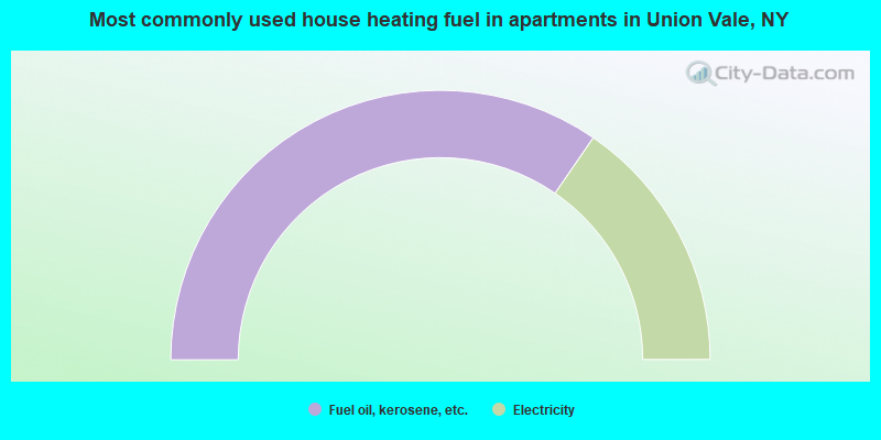
- 69.2%Fuel oil, kerosene, etc.
- 30.8%Electricity
Union Vale compared to New York state average:
- Median household income above state average.
- Unemployed percentage significantly below state average.
- Black race population percentage significantly below state average.
- Hispanic race population percentage significantly below state average.
- Foreign-born population percentage significantly below state average.
- Renting percentage significantly below state average.
- Length of stay since moving in significantly above state average.
- Number of rooms per house significantly below state average.
- House age significantly below state average.
Union Vale on our top lists:
- #8 on the list of "Top 101 cities with the largest percentage of people in homes for the mentally retarded (population 1,000+)"
- #3 on the list of "Top 101 counties with the largest decrease in the number of infant deaths per 1000 residents 2000-2006 to 2007-2013 (pop. 50,000+)"
- #4 on the list of "Top 101 counties with the lowest number of infant deaths per 1000 residents 2007-2013 (pop. 50,000+)"
- #28 on the list of "Top 101 counties with the lowest number of births per 1000 residents 2007-2013"
- #49 on the list of "Top 101 counties with the largest decrease in the number of births per 1000 residents 2000-2006 to 2007-2013 (pop 50,000+)"