Dover, New York
Dover: Beautiful Sunset #4

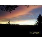
Dover: Beautiful Sunset

Dover: Quarry on Sand Hill Road, Dover Plains, NY Taken 21 April 2012
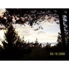
Dover: Beautiful Sunset #3
- add
your
Submit your own pictures of this town and show them to the world
- OSM Map
- Google Map
- MSN Map
Population change since 2000: +1.6%
 |
| Males: 4,409 | |
| Females: 4,290 |
| Median resident age: | 40.8 years |
| New York median age: | 40.7 years |
Zip codes: 12522.
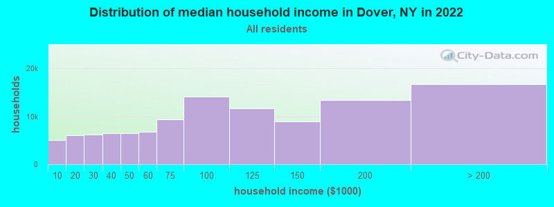
| Dover: | $86,224 |
| NY: | $79,557 |
Estimated per capita income in 2022: $43,936 (it was $21,250 in 2000)
Dover town income, earnings, and wages data
Estimated median house or condo value in 2022: $325,340 (it was $130,900 in 2000)
| Dover: | $325,340 |
| NY: | $400,400 |
Mean prices in 2022: all housing units: $414,214; detached houses: $452,020; townhouses or other attached units: $307,694; in 2-unit structures: $268,927; in 3-to-4-unit structures: $222,482; in 5-or-more-unit structures: $275,815; mobile homes: $90,593
Detailed information about poverty and poor residents in Dover, NY


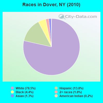
- 6,82878.5%White alone
- 1,19913.8%Hispanic
- 3794.4%Black alone
- 1581.8%Two or more races
- 1151.3%Asian alone
- 170.2%American Indian alone
- 30.03%Other race alone
Races in Dover detailed stats: ancestries, foreign born residents, place of birth
According to our research of New York and other state lists, there were 2 registered sex offenders living in Dover, New York as of April 30, 2024.
The ratio of all residents to sex offenders in Dover is 4,350 to 1.
The ratio of registered sex offenders to all residents in this city is much lower than the state average.
 Recent articles from our blog. Our writers, many of them Ph.D. graduates or candidates, create easy-to-read articles on a wide variety of topics.
Ancestries: Irish (28.3%), Italian (18.3%), German (14.4%), English (9.9%), French (5.1%), United States (4.9%).
Current Local Time: EST time zone
Land area: 55.7 square miles.
Population density: 156 people per square mile (very low).
489 residents are foreign born (2.8% Latin America, 2.6% Europe).
| This town: | 5.7% |
| New York: | 20.4% |
| Dover town: | 2.1% ($2,770) |
| New York: | 1.9% ($2,847) |
Nearest city with pop. 50,000+: Danbury, CT  (20.7 miles , pop. 74,848).
Nearest city with pop. 200,000+: Bronx, NY (60.2 miles , pop. 1,332,650).
Nearest cities:
), ), ), Latitude: 41.69 N, Longitude: 73.58 W
Area code commonly used in this area: 845
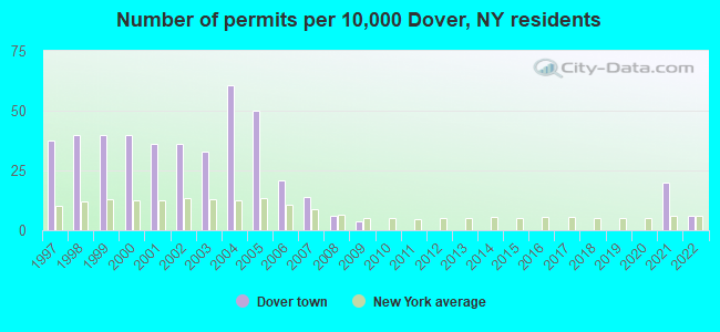
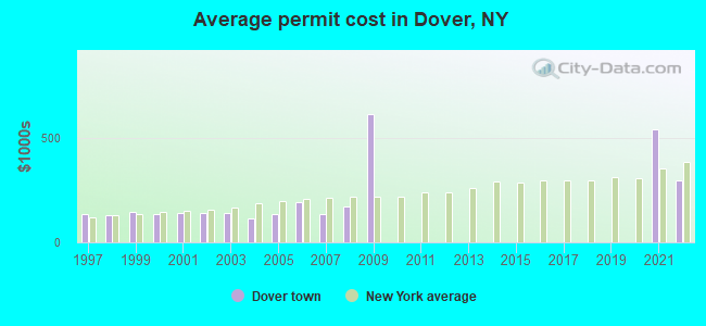
Single-family new house construction building permits:
- 2022: 5 buildings, average cost: $298,700
- 2021: 17 buildings, average cost: $540,600
- 2009: 3 buildings, average cost: $616,700
- 2008: 5 buildings, average cost: $173,800
- 2007: 12 buildings, average cost: $135,100
- 2006: 18 buildings, average cost: $194,900
- 2005: 43 buildings, average cost: $134,200
- 2004: 52 buildings, average cost: $114,500
- 2003: 28 buildings, average cost: $139,800
- 2002: 31 buildings, average cost: $139,700
- 2001: 31 buildings, average cost: $140,100
- 2000: 34 buildings, average cost: $138,300
- 1999: 34 buildings, average cost: $146,300
- 1998: 34 buildings, average cost: $129,800
- 1997: 32 buildings, average cost: $133,800
| Here: | 3.6% |
| New York: | 4.4% |
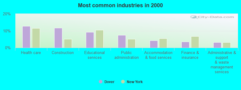
- Health care (12.8%)
- Construction (11.6%)
- Educational services (9.3%)
- Public administration (7.5%)
- Accommodation & food services (4.2%)
- Finance & insurance (3.5%)
- Administrative & support & waste management services (3.2%)
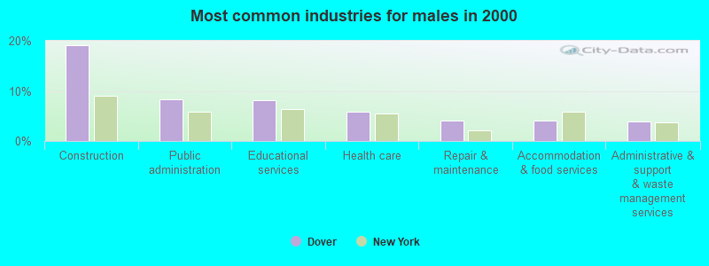
- Construction (19.2%)
- Public administration (8.3%)
- Educational services (8.1%)
- Health care (5.9%)
- Repair & maintenance (4.2%)
- Accommodation & food services (4.2%)
- Administrative & support & waste management services (3.8%)
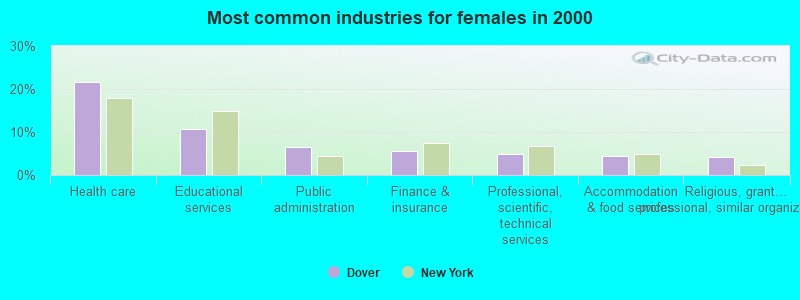
- Health care (21.7%)
- Educational services (10.8%)
- Public administration (6.4%)
- Finance & insurance (5.5%)
- Professional, scientific, technical services (4.9%)
- Accommodation & food services (4.4%)
- Religious, grantmaking, civic, professional, similar organizations (4.1%)
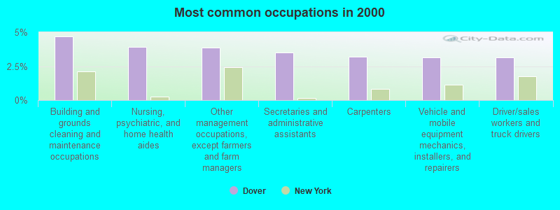
- Building and grounds cleaning and maintenance occupations (4.7%)
- Nursing, psychiatric, and home health aides (3.9%)
- Other management occupations, except farmers and farm managers (3.8%)
- Secretaries and administrative assistants (3.5%)
- Carpenters (3.2%)
- Vehicle and mobile equipment mechanics, installers, and repairers (3.2%)
- Driver/sales workers and truck drivers (3.1%)
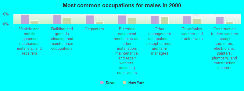
- Vehicle and mobile equipment mechanics, installers, and repairers (5.5%)
- Building and grounds cleaning and maintenance occupations (5.5%)
- Carpenters (5.4%)
- Electrical equipment mechanics and other installation, maintenance, and repair workers, including supervisors (5.3%)
- Other management occupations, except farmers and farm managers (4.8%)
- Driver/sales workers and truck drivers (4.6%)
- Construction traders workers except carpenters, electricians, painters, plumbers, and construction laborers (4.4%)
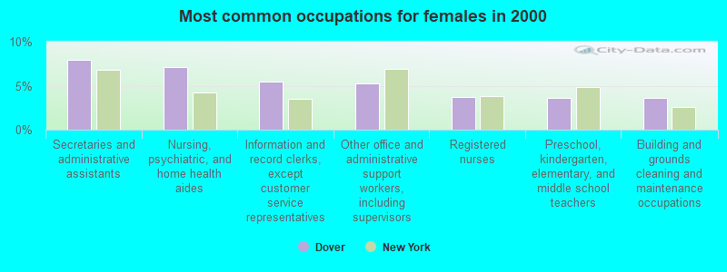
- Secretaries and administrative assistants (8.0%)
- Nursing, psychiatric, and home health aides (7.1%)
- Information and record clerks, except customer service representatives (5.4%)
- Other office and administrative support workers, including supervisors (5.2%)
- Registered nurses (3.7%)
- Preschool, kindergarten, elementary, and middle school teachers (3.6%)
- Building and grounds cleaning and maintenance occupations (3.6%)
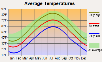
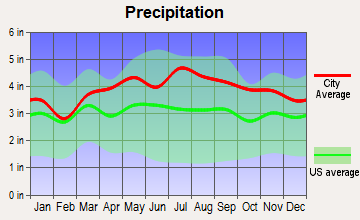
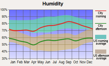
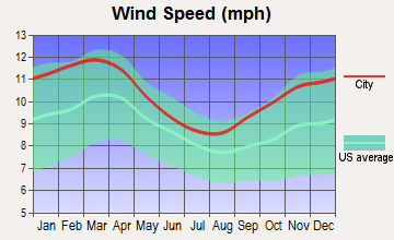
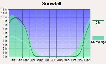
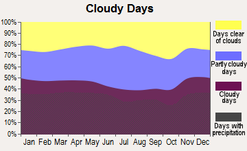
Average climate in Dover, New York
Based on data reported by over 4,000 weather stations

(lower is better)
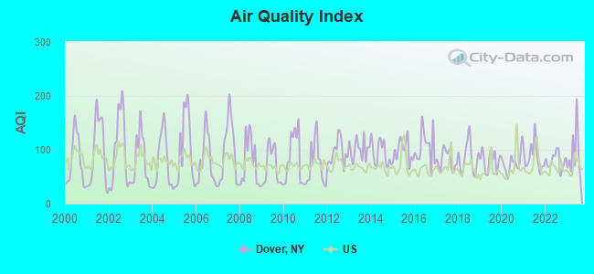
Air Quality Index (AQI) level in 2023 was 92.6. This is worse than average.
| City: | 92.6 |
| U.S.: | 72.6 |
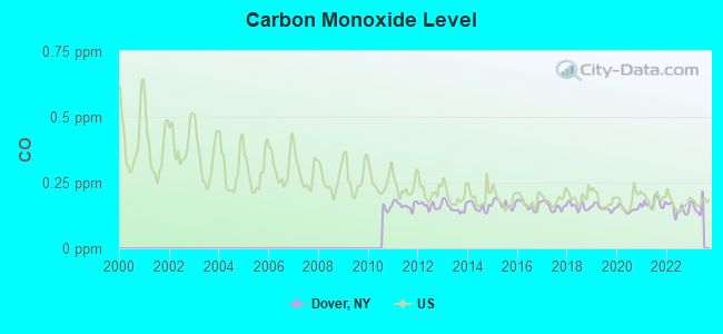
Carbon Monoxide (CO) [ppm] level in 2022 was 0.149. This is significantly better than average. Closest monitor was 17.3 miles away from the city center.
| City: | 0.149 |
| U.S.: | 0.251 |

Nitrogen Dioxide (NO2) [ppb] level in 2015 was 2.27. This is significantly better than average. Closest monitor was 10.3 miles away from the city center.
| City: | 2.27 |
| U.S.: | 5.11 |
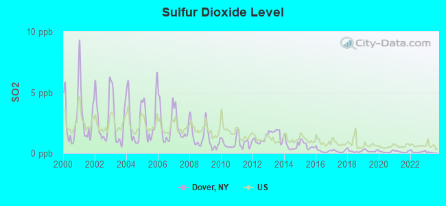
Sulfur Dioxide (SO2) [ppb] level in 2022 was 0.109. This is significantly better than average. Closest monitor was 10.3 miles away from the city center.
| City: | 0.109 |
| U.S.: | 1.515 |
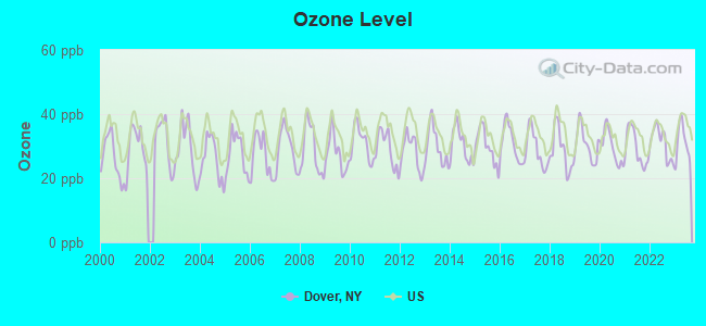
Ozone [ppb] level in 2023 was 31.2. This is about average. Closest monitor was 10.6 miles away from the city center.
| City: | 31.2 |
| U.S.: | 33.3 |
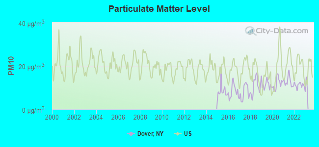
Particulate Matter (PM10) [µg/m3] level in 2022 was 11.1. This is significantly better than average. Closest monitor was 17.3 miles away from the city center.
| City: | 11.1 |
| U.S.: | 19.2 |
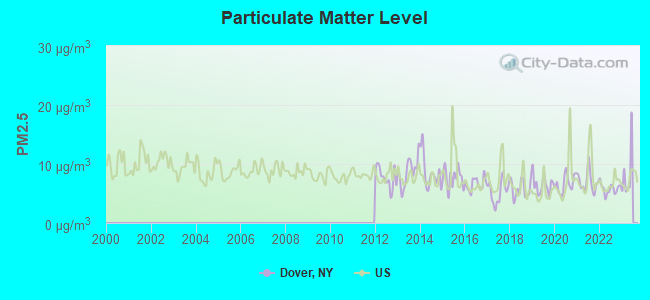
Particulate Matter (PM2.5) [µg/m3] level in 2022 was 5.81. This is better than average. Closest monitor was 17.2 miles away from the city center.
| City: | 5.81 |
| U.S.: | 8.11 |
Tornado activity:
Dover-area historical tornado activity is above New York state average. It is 25% smaller than the overall U.S. average.
On 5/29/1995, a category F4 (max. wind speeds 207-260 mph) tornado 36.2 miles away from the Dover town center killed 3 people and injured 24 people and caused between $5,000,000 and $50,000,000 in damages.
On 7/10/1989, a category F4 tornado 41.2 miles away from the town center injured 40 people and caused between $50,000,000 and $500,000,000 in damages.
Earthquake activity:
Dover-area historical earthquake activity is significantly above New York state average. It is 69% smaller than the overall U.S. average.On 10/7/1983 at 10:18:46, a magnitude 5.3 (5.1 MB, 5.3 LG, 5.1 ML, Class: Moderate, Intensity: VI - VII) earthquake occurred 161.3 miles away from the city center
On 4/20/2002 at 10:50:47, a magnitude 5.3 (5.3 ML, Depth: 3.0 mi) earthquake occurred 195.3 miles away from Dover center
On 4/20/2002 at 10:50:47, a magnitude 5.2 (5.2 MB, 4.2 MS, 5.2 MW, 5.0 MW) earthquake occurred 193.6 miles away from the city center
On 8/23/2011 at 17:51:04, a magnitude 5.8 (5.8 MW, Depth: 3.7 mi) earthquake occurred 349.1 miles away from Dover center
On 1/19/1982 at 00:14:42, a magnitude 4.7 (4.5 MB, 4.7 MD, 4.5 LG, Class: Light, Intensity: IV - V) earthquake occurred 160.8 miles away from the city center
On 1/16/1994 at 01:49:16, a magnitude 4.6 (4.6 MB, 4.6 LG, Depth: 3.1 mi) earthquake occurred 159.0 miles away from the city center
Magnitude types: regional Lg-wave magnitude (LG), body-wave magnitude (MB), duration magnitude (MD), local magnitude (ML), surface-wave magnitude (MS), moment magnitude (MW)
Natural disasters:
The number of natural disasters in Dutchess County (19) is greater than the US average (15).Major Disasters (Presidential) Declared: 12
Emergencies Declared: 6
Causes of natural disasters: Storms: 5, Floods: 4, Hurricanes: 4, Blizzards: 2, Snowstorms: 2, Winter Storms: 2, Power Outage: 1, Water Shortage: 1, Other: 3 (Note: some incidents may be assigned to more than one category).
Hospitals and medical centers near Dover:
- KENT, LTD, THE (Nursing Home, about 6 miles away; KENT, CT)
- TACONIC DDSO (Hospital, about 7 miles away; WASSAIC, NY)
- LIFESPIRE, INC (Hospital, about 8 miles away; WOODSIDE, NY)
- DUTCHESS CENTER FOR REHAB AND HEALTHCARE (Nursing Home, about 8 miles away; PAWLING, NY)
- NEW HORIZONS RESOURCES, INC. (Hospital, about 11 miles away; PLEASANT VALLEY, NY)
- NEW MILFORD VNA INC (Home Health Center, about 11 miles away; NEW MILFORD, CT)
- CANDLEWOOD VALLEY HEALTH AND R (Nursing Home, about 12 miles away; NEW MILFORD, CT)
Colleges/universities with over 2000 students nearest to Dover:
- Vassar College (about 17 miles; Poughkeepsie, NY; Full-time enrollment: 2,469)
- Dutchess Community College (about 17 miles; Poughkeepsie, NY; FT enrollment: 6,554)
- Marist College (about 19 miles; Poughkeepsie, NY; FT enrollment: 5,536)
- Culinary Institute of America (about 19 miles; Hyde Park, NY; FT enrollment: 3,869)
- Western Connecticut State University (about 22 miles; Danbury, CT; FT enrollment: 5,345)
- Mount Saint Mary College (about 26 miles; Newburgh, NY; FT enrollment: 2,166)
- State University of New York at New Paltz (about 27 miles; New Paltz, NY; FT enrollment: 7,319)
Points of interest:
Notable locations in Dover: Dover Plains Station (A), Harlem Valley-Wingdale Station (B), Metropolitan Camps (C), Camp Siwanoy (D), East Mountain Farm And Stables (E), Dover Town Hall (F), Dover Plains Library (G), Crystal House Manor Assisted Living Facility (H), Dover Fire Department - J H Ketcham Hose Company (I), J H Ketchum Hose Company Wingdale Station (J). Display/hide their locations on the map
Churches in Dover include: Dover Plains United Methodist Church (A), Saint James Episcopal Church (B), Saint Charles Church (C), Dover Plains Second Baptist Church (D). Display/hide their locations on the map
Cemetery: Valley View Cemetery (1). Display/hide its location on the map
Lakes and swamps: Jones Pond (A), Ore Pond (B), Sharparoon Pond (C), Pell Lake (D), Bear Swamp (E), Crane Pond (F), Depression Pond (G), Duck Pond (H). Display/hide their locations on the map
Streams, rivers, and creeks: Beaver Brook (A), Burton Brook (B), Stony Brook (C), Swamp River (D), Stone Church Brook (E), Doctors Brook (F), Deuel Hollow Brook (G), Coopertown Brook (H), Wells Brook (I). Display/hide their locations on the map
Park in Dover: Ketcham Park (1). Display/hide its location on the map
| This town: | 2.6 people |
| New York: | 2.6 people |
| This town: | 70.3% |
| Whole state: | 63.5% |
| This town: | 7.7% |
| Whole state: | 6.8% |
Likely homosexual households (counted as self-reported same-sex unmarried-partner households)
- Lesbian couples: 0.4% of all households
- Gay men: 0.5% of all households
| This town: | 8.4% |
| Whole state: | 14.6% |
| This town: | 2.5% |
| Whole state: | 7.4% |
People in group quarters in Dover in 2010:
- 32 people in group homes intended for adults
- 15 people in other noninstitutional facilities
- 9 people in residential treatment centers for adults
People in group quarters in Dover in 2000:
- 155 people in training schools for juvenile delinquents
- 38 people in other noninstitutional group quarters
- 28 people in homes for the mentally retarded
- 17 people in mental (psychiatric) hospitals or wards
For population 15 years and over in Dover:
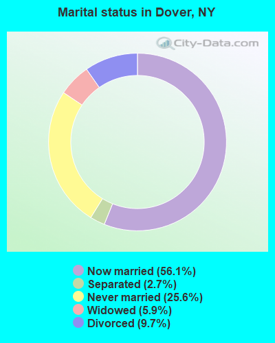
- Never married: 25.6%
- Now married: 56.1%
- Separated: 2.7%
- Widowed: 5.9%
- Divorced: 9.7%
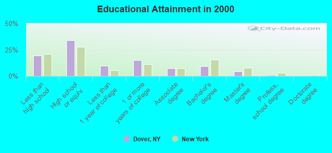
For population 25 years and over in Dover:
- High school or higher: 80.5%
- Bachelor's degree or higher: 14.5%
- Graduate or professional degree: 5.5%
- Unemployed: 3.8%
- Mean travel time to work (commute): 35.8 minutes
| Here: | 10.3 |
| New York average: | 14.2 |
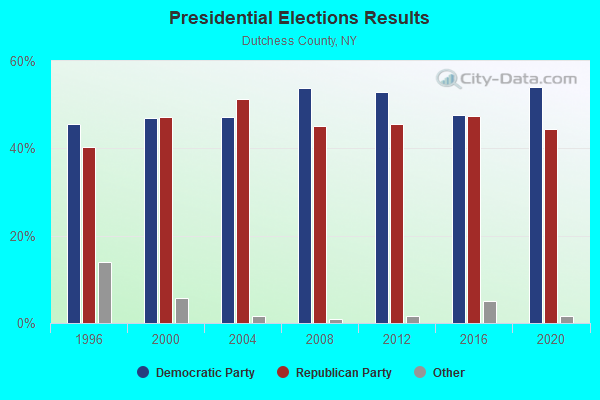
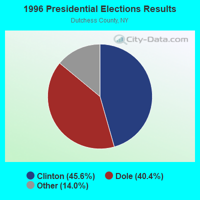
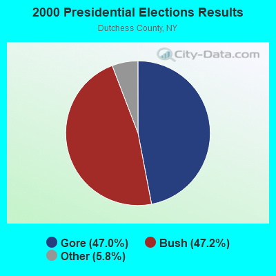
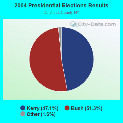
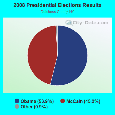
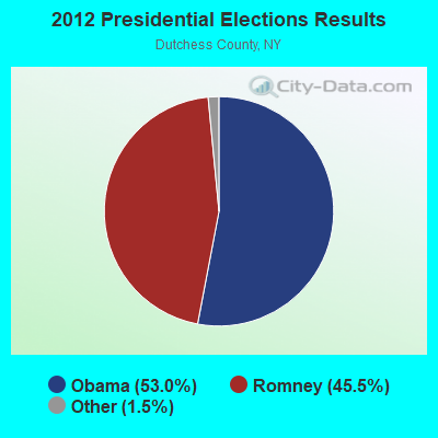
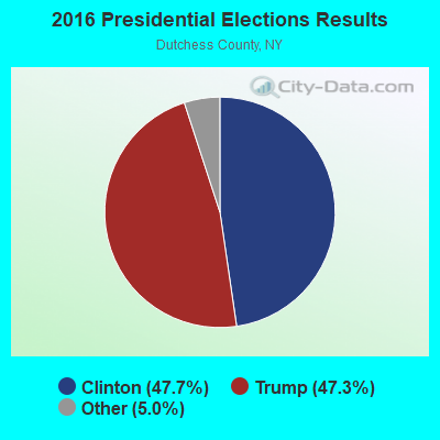

Graphs represent county-level data. Detailed 2008 Election Results
Religion statistics for Dover, NY (based on Dutchess County data)
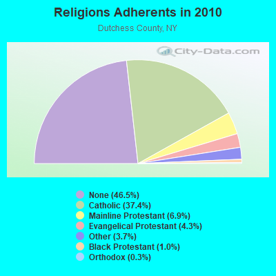
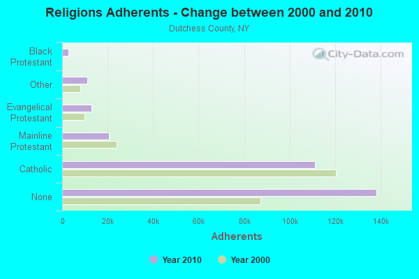
| Religion | Adherents | Congregations |
|---|---|---|
| Catholic | 111,112 | 22 |
| Mainline Protestant | 20,556 | 87 |
| Evangelical Protestant | 12,799 | 69 |
| Other | 10,970 | 28 |
| Black Protestant | 2,898 | 11 |
| Orthodox | 854 | 5 |
| None | 138,299 | - |
Food Environment Statistics:
| Here: | 3.42 / 10,000 pop. |
| New York: | 4.13 / 10,000 pop. |
| Dutchess County: | 0.10 / 10,000 pop. |
| New York: | 0.06 / 10,000 pop. |
| Here: | 1.16 / 10,000 pop. |
| State: | 0.92 / 10,000 pop. |
| Dutchess County: | 2.63 / 10,000 pop. |
| New York: | 1.68 / 10,000 pop. |
| This county: | 10.33 / 10,000 pop. |
| State: | 8.82 / 10,000 pop. |
| Here: | 8.1% |
| New York: | 8.2% |
| Dutchess County: | 24.4% |
| New York: | 23.8% |
| Here: | 13.4% |
| New York: | 15.6% |
Strongest AM radio stations in Dover:
- WTIC (1080 AM; 50 kW; HARTFORD, CT; Owner: INFINITY RADIO OPERATIONS INC.)
- WNNZ (640 AM; 50 kW; WESTFIELD, MA; Owner: CLEAR CHANNEL BROADCASTING LICENSES, INC.)
- WFAN (660 AM; 50 kW; NEW YORK, NY; Owner: INFINITY BROADCASTING OPERATIONS, INC.)
- WABC (770 AM; 50 kW; NEW YORK, NY; Owner: WABC-AM RADIO, INC.)
- WMCA (570 AM; 50 kW; NEW YORK, NY; Owner: SALEM MEDIA OF NEW YORK, LLC)
- WCBS (880 AM; 50 kW; NEW YORK, NY; Owner: INFINITY BROADCASTING OPERATIONS, INC.)
- WOR (710 AM; 50 kW; NEW YORK, NY; Owner: BUCKLEY BROADCASTING CORPORATION)
- WEOK (1390 AM; 5 kW; POUGHKEEPSIE, NY)
- WINS (1010 AM; 50 kW; NEW YORK, NY; Owner: INFINITY BROADCASTING OPERATIONS, INC.)
- WEPN (1050 AM; 50 kW; NEW YORK, NY; Owner: NEW YORK AM RADIO, LLC)
- WBBR (1130 AM; 50 kW; NEW YORK, NY; Owner: BLOOMBERG COMMUNICATIONS INC.)
- WGSM (740 AM; 25 kW; HUNTINGTON, NY; Owner: K RADIO LICENSEE, INC.)
- WGY (810 AM; 50 kW; SCHENECTADY, NY; Owner: CLEAR CHANNEL BROADCASTING LICENSES, INC.)
Strongest FM radio stations in Dover:
- W206AW (89.1 FM; PAWLING, NY; Owner: SOUND OF LIFE, INC.)
- WRNQ (92.1 FM; POUGHKEEPSIE, NY; Owner: CLEAR CHANNEL BROADCASTING LICENSES, INC.)
- WQQQ (103.3 FM; SHARON, CT; Owner: THE RIDGEFIELD BROADCASTING CORPORATION)
- WPDH (101.5 FM; POUGHKEEPSIE, NY; Owner: CUMULUS LICENSING CORP.)
- WDBY (105.5 FM; PATTERSON, NY; Owner: CUMULUS LICENSING CORP.)
- WFNP (88.7 FM; ROSENDALE, NY; Owner: STATE UNIVERSITY OF NEW YORK)
- WRHV (88.7 FM; POUGHKEEPSIE, NY; Owner: WMHT EDUCATIONAL TELECOMMUNICATIONS)
- W218AV (91.5 FM; WARREN, CT; Owner: MONROE BOARD OF EDUCATION)
- WSPK (104.7 FM; POUGHKEEPSIE, NY; Owner: 6 JOHNSON ROAD LICENSES, INC.)
- WCZX (97.7 FM; HYDE PARK, NY; Owner: CUMULUS LICENSING CORP.)
- WRRB (96.9 FM; ARLINGTON, NY; Owner: CUMULUS LICENSING CORP.)
- WRKI (95.1 FM; BROOKFIELD, CT; Owner: CUMULUS LICENSING CORP.)
- WBWZ (93.3 FM; NEW PALTZ, NY; Owner: CLEVELAND RADIO LICENSES, LLC)
- WRWD-FM (107.3 FM; HIGHLAND, NY; Owner: CLEVELAND RADIO LICENSES, LLC)
- WGSK (90.1 FM; SOUTH KENT, CT; Owner: MONROE BOARD OF EDUCATION)
- WKZE-FM (98.1 FM; SALISBURY, CT; Owner: JOHNSON DEVELOPMENT, INC.)
- W292CM (106.3 FM; POUGHKEEPSIE, NY; Owner: JOHN KATONAH)
- WFKP (99.3 FM; ELLENVILLE, NY; Owner: CLEAR CHANNEL BROADCASTING LICENSES, INC.)
- WAMK (90.9 FM; KINGSTON, NY; Owner: W A M C)
- WFGB (89.7 FM; KINGSTON, NY; Owner: SOUND OF LIFE, INC.)
TV broadcast stations around Dover:
- WTIC-TV (Channel 61; HARTFORD, CT; Owner: TRIBUNE TELEVISION COMPANY)
- W11BJ (Channel 11; HARTFORD, CT; Owner: COMMUNICATIONS SITE MANAGEMENT LLC)
- WTBY (Channel 54; POUGHKEEPSIE, NY; Owner: TRINITY BROADCASTING OF NEW YORK, INC.)
- WTXX (Channel 20; WATERBURY, CT; Owner: WTXX INC.)
- WVIT (Channel 30; NEW BRITAIN, CT; Owner: OUTLET BROADCASTING, INC)
- WEDH (Channel 24; HARTFORD, CT; Owner: CONNECTICUT PUBLIC BROADCASTING, INC.)
- WUVN (Channel 18; HARTFORD, CT; Owner: ENTRAVISION HOLDINGS, LLC)
- WTNH (Channel 8; NEW HAVEN, CT; Owner: WTNH BROADCASTING, INC.)
- WCTX (Channel 59; NEW HAVEN, CT; Owner: WTNH BROADCASTING, INC.)
- WEDY (Channel 65; NEW HAVEN, CT; Owner: CONNECTICUT PUBLIC BROADCASTING, INC.)
- WRNN-TV (Channel 62; KINGSTON, NY; Owner: WRNN-TV ASSOCIATES LIMITED PARTNERSHIP)
- National Bridge Inventory (NBI) Statistics
- 17Number of bridges
- 135ft / 40.7mTotal length
- $36,248,000Total costs
- 35,393Total average daily traffic
- 2,696Total average daily truck traffic
- 40,838Total future (year 2035) average daily traffic
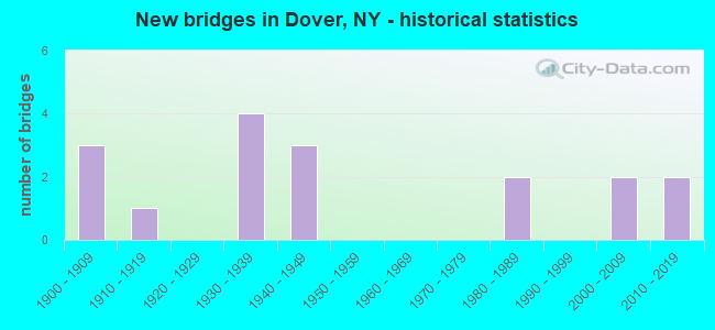
- New bridges - historical statistics
- 31900-1909
- 11910-1919
- 41930-1939
- 31940-1949
- 21980-1989
- 22000-2009
- 22010-2019
FCC Registered Cell Phone Towers:
1- East Mountain Road (Lat: 41.714694 Lon: -73.534389), Type: Mtower, Structure height: 55.2 m, Overall height: 60.1 m, Call Sign: KNKA455, Licensee ID: L00128694
Assigned Frequencies: 869.040 MHz, 869.040 MHz, 869.040 MHz, 824.040 MHz, 824.040 MHz, 824.040 MHz, 890.010 MHz, 890.010 MHz, 890.010 MHz, 845.010 MHz, 845.010 MHz, 845.010 MHzGrant Date: 01/09/2018, Expiration Date: 01/22/2028, Certifier: Michael P GogginRegistrant: New Cingular Wireless Pcs, LLC
FCC Registered Private Land Mobile Towers:
1- Atop East Mountain (Lat: 41.713972 Lon: -73.534861), Type: Tower, Structure height: 55 m, Overall height: 60 m, Call Sign: WPJR278, Licensee ID: L01422065,
Assigned Frequencies: 929.962 MHz, Grant Date: 10/24/2006, Expiration Date: 09/16/2016, Cancellation Date: 05/09/2014, Certifier: Shawn E Endsley, Registrant: Usa Mobility Wireless, Inc., 3000 Technology Dr. #400, Plano, TX 75074, Phone: (972) 801-0000, Fax: (972) 801-1699, Email:
FCC Registered Microwave Towers:
2- E MOUNTAIN, 4 Km Se Of Dover Plains (Lat: 41.713889 Lon: -73.535278), Type: Tower, Structure height: 55 m, Overall height: 56.5 m, Call Sign: WPTR630,
Assigned Frequencies: 934.375 MHz, Grant Date: 10/14/2021, Expiration Date: 11/30/2031, Certifier: Russell V Whittaker Jr., Registrant: Dutcehss County, 392 Creek Road, Poughkeepsie, NY 12601, Phone: (845) 486-2080, Fax: (845) 486-3998, Email:
- DOVER, East Mountain Road (Lat: 41.714694 Lon: -73.534389), Type: Mtower, Structure height: 55.2 m, Overall height: 60 m, Call Sign: WQSE406,
Assigned Frequencies: 11585.0 MHz, Grant Date: 08/16/2023, Expiration Date: 09/10/2033, Certifier: John Monday, Registrant: At&t Services, Inc., 208 S Akard St, 20f, Dallas, TX 75202, Phone: (855) 699-7073, Email:
FCC Registered Amateur Radio Licenses:
2- Call Sign: KA3RFI, Licensee ID: L00153982, Grant Date: 03/07/2023, Expiration Date: 03/16/2033, Certifier: Montel M Tyler, Registrant: Montel M Tyler, 3321 Jodi Ln, Dover, NY 17315
- Call Sign: N2DLP, Previous Call Sign: KA2IAN, Grant Date: 02/23/1988, Expiration Date: 02/23/1998, Cancellation Date: 02/24/2000, Registrant: Michael Panucci, 242 10 Mile River Dr, Dover, NY 12522
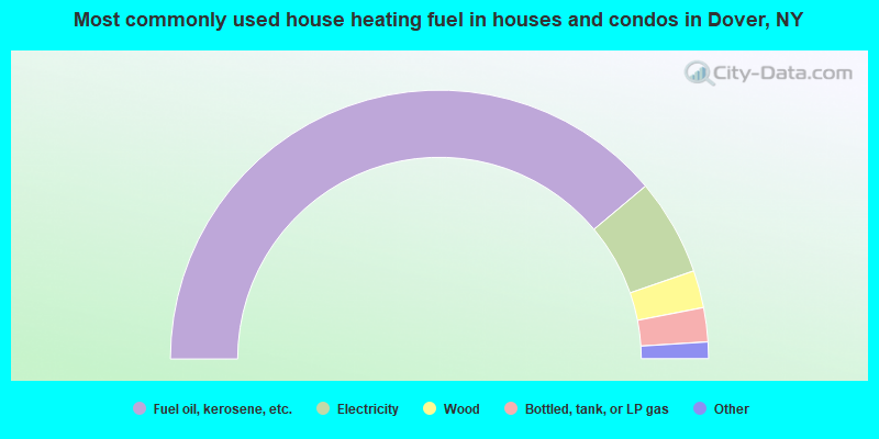
- 77.7%Fuel oil, kerosene, etc.
- 11.6%Electricity
- 4.5%Wood
- 4.1%Bottled, tank, or LP gas
- 1.3%Utility gas
- 0.6%Other fuel
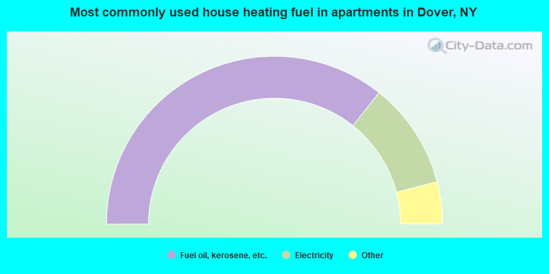
- 71.4%Fuel oil, kerosene, etc.
- 20.5%Electricity
- 3.0%Bottled, tank, or LP gas
- 2.0%Wood
- 2.0%No fuel used
- 0.7%Other fuel
- 0.5%Utility gas
Dover compared to New York state average:
- Unemployed percentage significantly below state average.
- Black race population percentage significantly below state average.
- Foreign-born population percentage significantly below state average.
- Renting percentage below state average.
- Length of stay since moving in significantly above state average.
- Number of rooms per house significantly below state average.
- House age significantly below state average.
- Percentage of population with a bachelor's degree or higher below state average.
Dover on our top lists:
- #12 on the list of "Top 101 cities with largest percentage of males in occupations: occupational and physical therapist assistants and aides (population 5,000+)"
- #14 on the list of "Top 101 cities with largest percentage of females in occupations: religious workers (population 5,000+)"
- #23 on the list of "Top 101 cities with largest percentage of females in occupations: bus drivers (population 5,000+)"
- #26 on the list of "Top 101 cities with largest percentage of males in industries: electrical and electronic goods merchant wholesalers (population 5,000+)"
- #27 on the list of "Top 101 cities with largest percentage of males in occupations: nursing, psychiatric, and home health aides (population 5,000+)"
- #27 on the list of "Top 101 cities with largest percentage of males in occupations: other construction workers and helpers (population 5,000+)"
- #27 on the list of "Top 101 cities with largest percentage of females in occupations: pipelayers, plumbers, pipefitters, and steamfitters (population 5,000+)"
- #28 on the list of "Top 101 cities with largest percentage of females in industries: religious, grantmaking, civic, professional, and similar organizations (population 5,000+)"
- #33 on the list of "Top 101 cities with largest percentage of females in industries: plastics and rubber products (population 5,000+)"
- #36 on the list of "Top 101 cities with the largest percentage of people in training schools for juvenile delinquents (population 1,000+)"
- #38 on the list of "Top 101 cities with largest percentage of females in industries: electrical and electronic goods merchant wholesalers (population 5,000+)"
- #42 on the list of "Top 101 cities with largest percentage of females in industries: retail florists (population 5,000+)"
- #43 on the list of "Top 101 cities with largest percentage of males in industries: plastics and rubber products (population 5,000+)"
- #44 on the list of "Top 101 cities with largest percentage of females in industries: building material and garden equipment and supplies dealers (population 5,000+)"
- #52 on the list of "Top 101 cities with largest percentage of females in industries: rail transportation (population 5,000+)"
- #53 on the list of "Top 101 cities with the most residents born in Other Central America (population 500+)"
- #55 on the list of "Top 101 cities with largest percentage of males in industries: fuel dealers (population 5,000+)"
- #64 on the list of "Top 101 cities with largest percentage of females in industries: furniture and related product manufacturing (population 5,000+)"
- #81 on the list of "Top 101 cities with largest percentage of males in industries: furniture and related product manufacturing (population 5,000+)"
- #81 on the list of "Top 101 cities with largest percentage of females in industries: wood products (population 5,000+)"
- #3 on the list of "Top 101 counties with the largest decrease in the number of infant deaths per 1000 residents 2000-2006 to 2007-2013 (pop. 50,000+)"
- #4 on the list of "Top 101 counties with the lowest number of infant deaths per 1000 residents 2007-2013 (pop. 50,000+)"
- #28 on the list of "Top 101 counties with the lowest number of births per 1000 residents 2007-2013"
- #49 on the list of "Top 101 counties with the largest decrease in the number of births per 1000 residents 2000-2006 to 2007-2013 (pop 50,000+)"