Westford, Vermont
Submit your own pictures of this town and show them to the world
- OSM Map
- General Map
- Google Map
- MSN Map

Population change since 2000: -2.7%
 |
| Males: 1,006 | |
| Females: 1,023 |
| Median resident age: | 41.5 years |
| Vermont median age: | 45.8 years |
Zip codes: 05494.
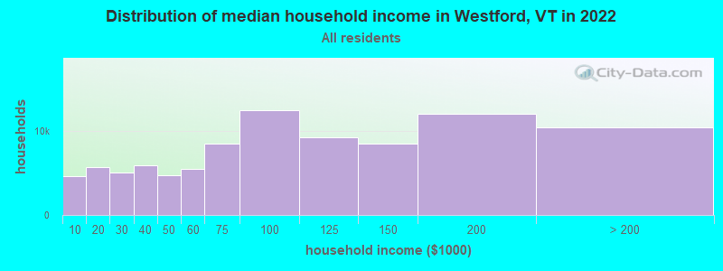
| Westford: | $112,483 |
| VT: | $73,991 |
Estimated per capita income in 2022: $45,135 (it was $23,056 in 2000)
Westford town income, earnings, and wages data
Estimated median house or condo value in 2022: $408,242 (it was $131,800 in 2000)
| Westford: | $408,242 |
| VT: | $304,700 |
Mean prices in 2022: all housing units: $491,172; detached houses: $528,845; townhouses or other attached units: $365,306; in 2-unit structures: $386,479; in 3-to-4-unit structures: over $1,000,000; in 5-or-more-unit structures: $298,866; mobile homes: $83,873
Detailed information about poverty and poor residents in Westford, VT


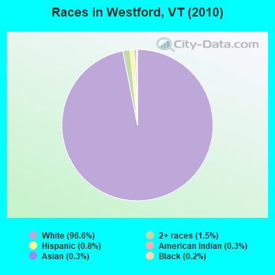
- 1,96196.6%White alone
- 301.5%Two or more races
- 170.8%Hispanic
- 70.3%American Indian alone
- 70.3%Asian alone
- 50.2%Black alone
- 20.10%Other race alone
Races in Westford detailed stats: ancestries, foreign born residents, place of birth
According to our research of Vermont and other state lists, there were 3 registered sex offenders living in Westford, Vermont as of May 18, 2024.
The ratio of all residents to sex offenders in Westford is 676 to 1.
The ratio of registered sex offenders to all residents in this city is lower than the state average.
 Recent articles from our blog. Our writers, many of them Ph.D. graduates or candidates, create easy-to-read articles on a wide variety of topics.

 | Essex Vermont (few questions for a Essex Local) (6 replies) |
| Less farmy, more woodsy? (10 replies) |
| Job Advice (3 replies) |
| Small artsy towns near Burlington (11 replies) |
| Anyone Work at Fletcher Allen? (17 replies) |
| Where to settle Islands or Essex? (13 replies) |
Latest news from Westford, VT collected exclusively by city-data.com from local newspapers, TV, and radio stations
Ancestries: English (19.1%), Irish (19.0%), French (14.7%), German (12.2%), French Canadian (11.1%), Italian (8.0%).
Current Local Time: EST time zone
Elevation: 467 feet
Land area: 39.3 square miles.
Population density: 52 people per square mile (very low).
76 residents are foreign born (1.9% Europe, 0.7% North America, 0.6% Latin America, 0.4% Asia).
| This town: | 3.6% |
| Vermont: | 3.8% |
| Westford town: | 1.8% ($2,364) |
| Vermont: | 2.0% ($2,196) |
Nearest city with pop. 50,000+: Schenectady, NY  (132.6 miles , pop. 61,821).
Nearest city with pop. 200,000+: Boston, MA (184.3 miles , pop. 589,141).
Nearest city with pop. 1,000,000+: Bronx, NY (263.3 miles , pop. 1,332,650).
Nearest cities:
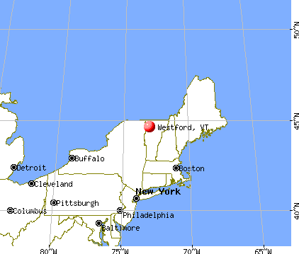
), ), Latitude: 44.60 N, Longitude: 73.00 W
Area code commonly used in this area: 802

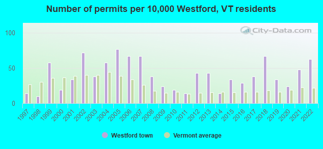
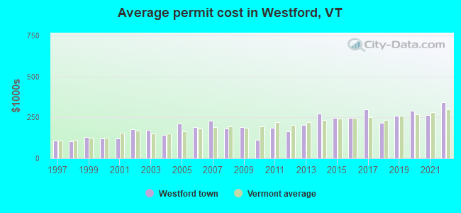
Single-family new house construction building permits:
- 2022: 13 buildings, average cost: $341,300
- 2021: 10 buildings, average cost: $266,300
- 2020: 5 buildings, average cost: $290,000
- 2019: 7 buildings, average cost: $259,400
- 2018: 14 buildings, average cost: $215,700
- 2017: 8 buildings, average cost: $297,900
- 2016: 6 buildings, average cost: $245,500
- 2015: 7 buildings, average cost: $245,800
- 2014: 3 buildings, average cost: $271,700
- 2013: 9 buildings, average cost: $203,800
- 2012: 9 buildings, average cost: $163,200
- 2011: 3 buildings, average cost: $186,700
- 2010: 4 buildings, average cost: $112,500
- 2009: 5 buildings, average cost: $190,000
- 2008: 8 buildings, average cost: $182,500
- 2007: 14 buildings, average cost: $228,600
- 2006: 14 buildings, average cost: $192,100
- 2005: 16 buildings, average cost: $211,400
- 2004: 12 buildings, average cost: $141,900
- 2003: 8 buildings, average cost: $173,900
- 2002: 15 buildings, average cost: $178,500
- 2001: 7 buildings, average cost: $121,900
- 2000: 4 buildings, average cost: $122,500
- 1999: 12 buildings, average cost: $131,500
- 1998: 2 buildings, average cost: $103,500
- 1997: 3 buildings, average cost: $108,300
| Here: | 1.4% |
| Vermont: | 2.0% |
- Educational services (14.5%)
- Computer & electronic products (11.5%)
- Health care (8.0%)
- Professional, scientific, technical services (6.5%)
- Construction (6.1%)
- Public administration (4.8%)
- Accommodation & food services (3.6%)
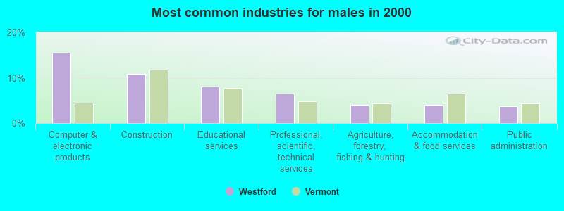
- Computer & electronic products (15.5%)
- Construction (10.9%)
- Educational services (8.0%)
- Professional, scientific, technical services (6.6%)
- Agriculture, forestry, fishing & hunting (4.0%)
- Accommodation & food services (4.0%)
- Public administration (3.7%)
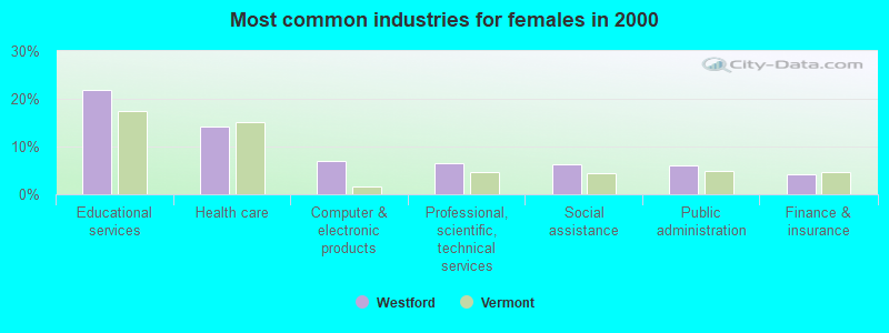
- Educational services (21.8%)
- Health care (14.1%)
- Computer & electronic products (7.0%)
- Professional, scientific, technical services (6.4%)
- Social assistance (6.2%)
- Public administration (6.1%)
- Finance & insurance (4.3%)
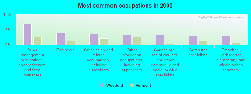
- Other management occupations, except farmers and farm managers (6.8%)
- Engineers (4.1%)
- Other sales and related occupations, including supervisors (3.6%)
- Other production occupations, including supervisors (3.3%)
- Counselors, social workers, and other community and social service specialists (3.2%)
- Computer specialists (2.9%)
- Preschool, kindergarten, elementary, and middle school teachers (2.9%)
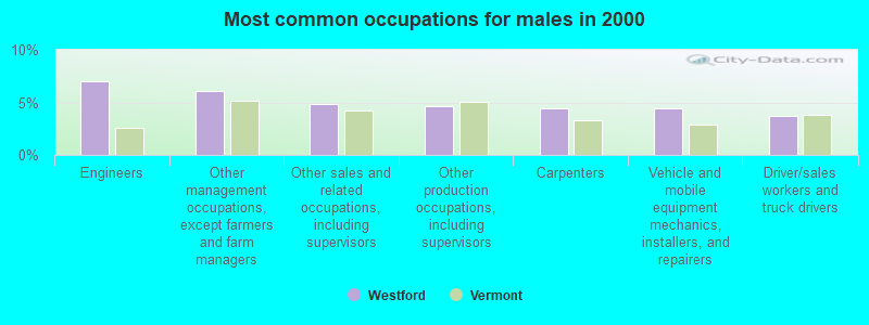
- Engineers (7.0%)
- Other management occupations, except farmers and farm managers (6.1%)
- Other sales and related occupations, including supervisors (4.8%)
- Other production occupations, including supervisors (4.6%)
- Carpenters (4.5%)
- Vehicle and mobile equipment mechanics, installers, and repairers (4.5%)
- Driver/sales workers and truck drivers (3.7%)
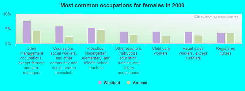
- Other management occupations, except farmers and farm managers (7.7%)
- Counselors, social workers, and other community and social service specialists (5.9%)
- Preschool, kindergarten, elementary, and middle school teachers (5.4%)
- Other teachers, instructors, education, training, and library occupations (4.1%)
- Child care workers (4.1%)
- Retail sales workers, except cashiers (3.9%)
- Registered nurses (3.6%)
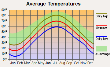
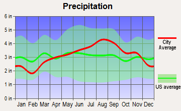
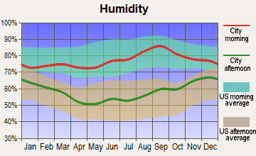
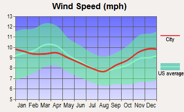
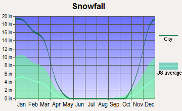
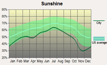
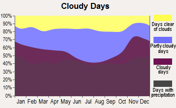
Average climate in Westford, Vermont
Based on data reported by over 4,000 weather stations
(lower is better)
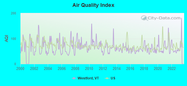
Air Quality Index (AQI) level in 2022 was 56.4. This is better than average.
| City: | 56.4 |
| U.S.: | 72.6 |
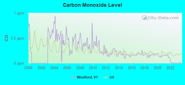
Carbon Monoxide (CO) [ppm] level in 2022 was 0.00585. This is significantly better than average. Closest monitor was 8.0 miles away from the city center.
| City: | 0.00585 |
| U.S.: | 0.25132 |
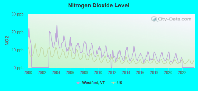
Nitrogen Dioxide (NO2) [ppb] level in 2021 was 4.81. This is about average. Closest monitor was 13.4 miles away from the city center.
| City: | 4.81 |
| U.S.: | 5.11 |
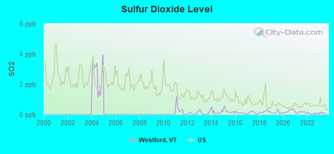
Sulfur Dioxide (SO2) [ppb] level in 2022 was 0.0619. This is significantly better than average. Closest monitor was 8.0 miles away from the city center.
| City: | 0.0619 |
| U.S.: | 1.5147 |
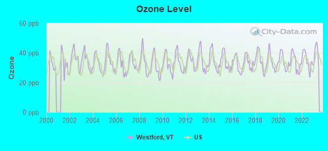
Ozone [ppb] level in 2022 was 34.8. This is about average. Closest monitor was 8.0 miles away from the city center.
| City: | 34.8 |
| U.S.: | 33.3 |
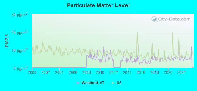
Particulate Matter (PM2.5) [µg/m3] level in 2022 was 5.19. This is significantly better than average. Closest monitor was 8.0 miles away from the city center.
| City: | 5.19 |
| U.S.: | 8.11 |
Earthquake activity:
Westford-area historical earthquake activity is significantly above Vermont state average. It is 72% smaller than the overall U.S. average.On 4/20/2002 at 10:50:47, a magnitude 5.3 (5.3 ML, Depth: 3.0 mi, Class: Moderate, Intensity: VI - VII) earthquake occurred 35.0 miles away from the city center
On 4/20/2002 at 10:50:47, a magnitude 5.2 (5.2 MB, 4.2 MS, 5.2 MW, 5.0 MW) earthquake occurred 36.3 miles away from the city center
On 10/7/1983 at 10:18:46, a magnitude 5.3 (5.1 MB, 5.3 LG, 5.1 ML) earthquake occurred 80.2 miles away from the city center
On 1/19/1982 at 00:14:42, a magnitude 4.7 (4.5 MB, 4.7 MD, 4.5 LG, Class: Light, Intensity: IV - V) earthquake occurred 103.0 miles away from the city center
On 10/16/2012 at 23:12:25, a magnitude 4.7 (4.7 ML, Depth: 10.0 mi) earthquake occurred 135.4 miles away from Westford center
On 4/20/2002 at 11:04:42, a magnitude 3.7 (3.7 ML, Depth: 3.1 mi, Class: Light, Intensity: II - III) earthquake occurred 34.9 miles away from the city center
Magnitude types: regional Lg-wave magnitude (LG), body-wave magnitude (MB), duration magnitude (MD), local magnitude (ML), surface-wave magnitude (MS), moment magnitude (MW)
Natural disasters:
The number of natural disasters in Chittenden County (24) is greater than the US average (15).Major Disasters (Presidential) Declared: 18
Emergencies Declared: 2
Causes of natural disasters: Floods: 16, Storms: 14, Heavy Rains: 3, Winter Storms: 2, Hurricane: 1, Ice Storm: 1, Landslide: 1, Snow: 1, Snowstorm: 1, Tropical Storm: 1, Wind: 1, Other: 1 (Note: some incidents may be assigned to more than one category).

Hospitals and medical centers near Westford:
- GREEN MOUNTAIN NURSING AND REHABILITATION (Nursing Home, about 11 miles away; COLCHESTER, VT)
- FANNY ALLEN HOSPITAL (Hospital, about 11 miles away; WINOOSKI, VT)
- BAYADA NURSES, INC (Home Health Center, about 13 miles away; SO BURLINGTON, VT)
- FLETCHER ALLEN HEALTHCARE - MED CTR HOSP OF VT CAMPUS (Dialysis Facility, about 13 miles away; BURLINGTON, VT)
- FLETCHER ALLEN HOSPITAL OF VERMONT Acute Care Hospitals (about 13 miles away; BURLINGTON, VT)
- FRANKLIN COUNTY REHAB CENTER LLC (Nursing Home, about 13 miles away; ST ALBANS, VT)
- VISITING NURSE ASSOCIATION (Home Health Center, about 13 miles away; COLCHESTER, VT)
Amtrak stations near Westford:
- 10 miles: BURLINGTON-ESSEX JUNCTION (ESSEX JUNCTION, 29 RAILROAD AVE.) . Services: ticket office, partially wheelchair accessible, enclosed waiting area, public restrooms, public payphones, vending machines, ATM, free short-term parking, free long-term parking, call for car rental service, call for taxi service, public transit connection.
- 16 miles: ST. ALBANS (40 FEDERAL ST.) . Services: ticket office, partially wheelchair accessible, enclosed waiting area, public restrooms, public payphones, full-service food facilities, ATM, free short-term parking, free long-term parking, call for car rental service.
Colleges/universities with over 2000 students nearest to Westford:
- Saint Michael's College (about 11 miles; Colchester, VT; Full-time enrollment: 2,336)
- Community College of Vermont (about 12 miles; Winooski, VT; FT enrollment: 3,394)
- University of Vermont (about 13 miles; Burlington, VT; FT enrollment: 11,566)
- Champlain College (about 14 miles; Burlington, VT; FT enrollment: 2,623)
- SUNY College at Plattsburgh (about 24 miles; Plattsburgh, NY; FT enrollment: 5,934)
- Norwich University (about 36 miles; Northfield, VT; FT enrollment: 4,221)
- Middlebury College (about 42 miles; Middlebury, VT; FT enrollment: 3,077)
Public elementary/middle school in Westford:
- WESTFORD ELEMENTARY SCHOOL (Students: 257, Location: 146 BROOKSIDE ROAD, Grades: PK-8)
Points of interest:
Notable location: Westford Fire Station (A). Display/hide its location on the map
Church in Westford: United Church of Westford (A). Display/hide its location on the map
Cemeteries: North Underhill Cemetery (1), Pleasant View Cemetery (2), Osgood Hill Cemetery (3), Westford Plains Cemetery (4), Brookside Cemetery (5). Display/hide their locations on the map
Lake: Westford Pond (A). Display/hide its location on the map
Streams, rivers, and creeks: Rogers Brook (A), Pond Brook (B), Morgan Brook (C). Display/hide their locations on the map
Birthplace of: Luke P. Poland - Politician.
Drinking water stations with addresses in Westford and their reported violations in the past:
WESTFORD ELEMENTARY SCHOOL (Address: 146 BROOKSIDE RD , Population served: 275, Groundwater):Past monitoring violations:WESTFORD FIRE DISTRICT 1 (Population served: 50, Groundwater):
- Follow-up Or Routine LCR Tap M/R - In OCT-01-2009, Contaminant: Lead and Copper Rule. Follow-up actions: St Formal NOV issued (JAN-26-2010), St Tech Assistance Visit (JAN-26-2010), St Other (JAN-26-2010), St Public Notif requested (JAN-26-2010), St Public Notif received (FEB-05-2010), St Compliance achieved (APR-26-2011)
- Follow-up Or Routine LCR Tap M/R - In JAN-01-1997, Contaminant: Lead and Copper Rule. Follow-up actions: St Violation/Reminder Notice (JUL-01-1997), St Compliance achieved (APR-26-2011)
Past health violations:Past monitoring violations:
- MCL, Monthly (TCR) - In AUG-2011, Contaminant: Coliform. Follow-up actions: St Public Notif requested (JAN-19-2012), St Formal NOV issued (JAN-19-2012), St Compliance achieved (NOV-02-2012)
- MCL, Monthly (TCR) - In JUL-2006, Contaminant: Coliform. Follow-up actions: St Formal NOV issued (AUG-03-2006), St Public Notif requested (AUG-03-2006), St Compliance achieved (JAN-29-2010)
- Monitoring and Reporting (DBP) - Between APR-2009 and JUN-2009, Contaminant: Chlorine. Follow-up actions: St Formal NOV issued (SEP-01-2009), St Compliance achieved (NOV-08-2012)
- Monitoring and Reporting (DBP) - Between JAN-2005 and DEC-2005, Contaminant: Total Haloacetic Acids (HAA5). Follow-up actions: St Public Notif requested (JUN-26-2006), St Formal NOV issued (JUN-26-2006), St Public Notif received (JUL-13-2006), St Compliance achieved (APR-26-2011)
- Monitoring and Reporting (DBP) - Between JAN-2005 and DEC-2005, Contaminant: TTHM. Follow-up actions: St Public Notif requested (JUN-26-2006), St Formal NOV issued (JUN-26-2006), St Public Notif received (JUL-13-2006), St Compliance achieved (APR-26-2011)
| This town: | 2.7 people |
| Vermont: | 2.3 people |
| This town: | 75.8% |
| Whole state: | 62.5% |
| This town: | 9.8% |
| Whole state: | 9.2% |
Likely homosexual households (counted as self-reported same-sex unmarried-partner households)
- Lesbian couples: 1.3% of all households
- Gay men: 0.4% of all households
| This town: | 4.9% |
| Whole state: | 9.4% |
| This town: | 1.5% |
| Whole state: | 3.6% |
For population 15 years and over in Westford:
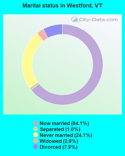
- Never married: 24.1%
- Now married: 64.1%
- Separated: 1.0%
- Widowed: 2.9%
- Divorced: 7.9%
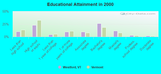
For population 25 years and over in Westford:
- High school or higher: 89.7%
- Bachelor's degree or higher: 43.1%
- Graduate or professional degree: 16.7%
- Unemployed: 3.1%
- Mean travel time to work (commute): 29.7 minutes
| Here: | 11.5 |
| Vermont average: | 11.7 |
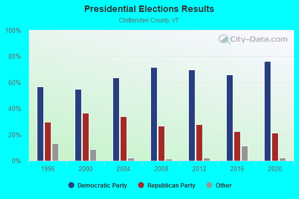
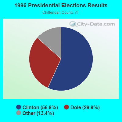
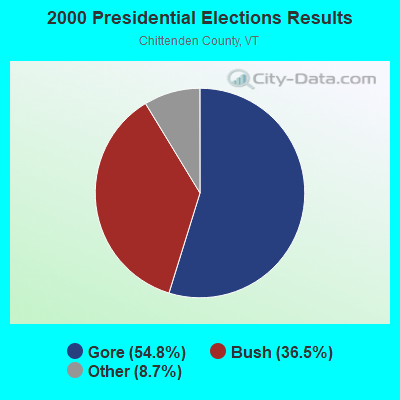
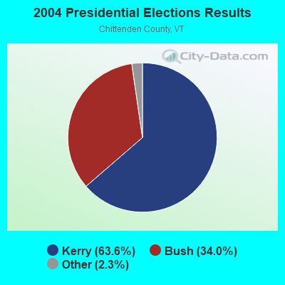

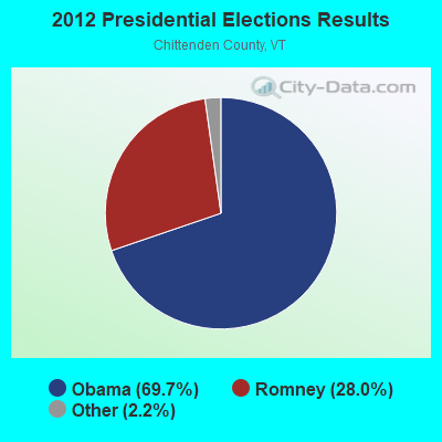
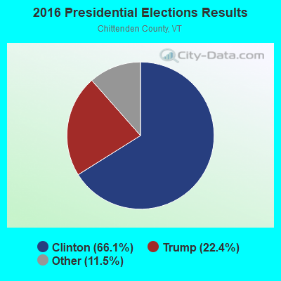
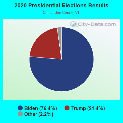
Graphs represent county-level data. Detailed 2008 Election Results
Religion statistics for Westford, VT (based on Chittenden County data)

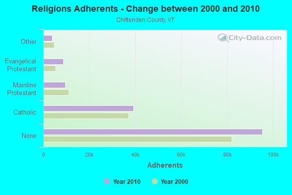
| Religion | Adherents | Congregations |
|---|---|---|
| Catholic | 39,143 | 19 |
| Mainline Protestant | 9,427 | 43 |
| Evangelical Protestant | 8,638 | 43 |
| Other | 3,891 | 20 |
| Orthodox | 100 | 1 |
| None | 95,346 | - |
Food Environment Statistics:
| Chittenden County: | 2.77 / 10,000 pop. |
| Vermont: | 3.84 / 10,000 pop. |
| This county: | 0.07 / 10,000 pop. |
| Vermont: | 0.07 / 10,000 pop. |
| Here: | 1.84 / 10,000 pop. |
| Vermont: | 1.95 / 10,000 pop. |
| Chittenden County: | 4.28 / 10,000 pop. |
| Vermont: | 6.40 / 10,000 pop. |
| This county: | 9.35 / 10,000 pop. |
| Vermont: | 11.52 / 10,000 pop. |
| Chittenden County: | 5.3% |
| Vermont: | 6.8% |
| This county: | 18.7% |
| Vermont: | 22.3% |
| Here: | 13.8% |
| Vermont: | 13.3% |
Strongest AM radio stations in Westford:
- WVMT (620 AM; 5 kW; BURLINGTON, VT; Owner: SISON BROADCASTING, INC.)
- WCHP (760 AM; 35 kW; CHAMPLAIN, NY; Owner: CHAMPLAIN RADIO, INC.)
- WVAA (1390 AM; 5 kW; BURLINGTON, VT; Owner: RADIO VERMONT, KDR, LLC)
- WDEV (550 AM; 5 kW; WATERBURY, VT; Owner: RADIO VERMONT, INC.)
- WEAV (960 AM; 5 kW; PLATTSBURGH, NY; Owner: CLEAR CHANNEL BROADCASTING LICENSES, INC.)
- WTWK (1070 AM; daytime; 5 kW; PLATTSBURGH, NY; Owner: CHAMPLAIN COMMUNICATIONS CORPORATION)
- WICY (1490 AM; 50 kW; MALONE, NY; Owner: CARTIER COMMUNICATIONS INC.)
- WJOY (1230 AM; 1 kW; BURLINGTON, VT; Owner: HALL COMMUNICATIONS, INC.)
- WGY (810 AM; 50 kW; SCHENECTADY, NY; Owner: CLEAR CHANNEL BROADCASTING LICENSES, INC.)
- WNNZ (640 AM; 50 kW; WESTFIELD, MA; Owner: CLEAR CHANNEL BROADCASTING LICENSES, INC.)
- WRSA (1420 AM; 1 kW; ST. ALBANS, VT)
- WRKO (680 AM; 50 kW; BOSTON, MA; Owner: ENTERCOM BOSTON LICENSE, LLC)
- WCRN (830 AM; 50 kW; WORCESTER, MA; Owner: CARTER BROADCASTING CORPORATION)
Strongest FM radio stations in Westford:
- WEZF (92.9 FM; BURLINGTON, VT; Owner: CAPSTAR TX LIMITED PARTNERSHIP)
- WVPS (107.9 FM; BURLINGTON, VT; Owner: VERMONT PUBLIC RADIO)
- WLKC (103.3 FM; WATERBURY, VT; Owner: RADIO BROADCASTING SERVICES, INC.)
- WCVT (101.7 FM; STOWE, VT; Owner: RADIO VERMONT CLASSICS, L.L.C.)
- WNCS (104.7 FM; MONTPELIER, VT; Owner: MONTPELIER BROADCASTING, INC.)
- WCPV (101.3 FM; ESSEX, NY; Owner: CAPSTAR TX LIMITED PARTNERSHIP)
- WLFE-FM (102.3 FM; ST. ALBANS, VT; Owner: CHAMPLAIN COMMUNICATIONS CORP.)
- WGLY-FM (91.5 FM; BOLTON, VT; Owner: CHRISTIAN MINISTRIES, INC.)
- WDEV-FM (96.1 FM; WARREN, VT; Owner: RADIO VERMONT, INC.)
- WCEL (91.9 FM; PLATTSBURGH, NY; Owner: WAMC)
- WXZO (96.7 FM; WILLSBORO, NY; Owner: CAPSTAR TX LIMITED PARTNERSHIP)
- WIZN (106.7 FM; VERGENNES, VT; Owner: BURLINGTON BROADCASTERS, INC.)
- WXLU (88.3 FM; PERU, NY; Owner: THE ST. LAWRENCE UNIVERSITY)
- WPKQ (103.7 FM; NORTH CONWAY, NH; Owner: CITADEL BROADCASTING COMPANY)
- WHOM (94.9 FM; MT. WASHINGTON, NH; Owner: CITADEL BROADCASTING COMPANY)
- WXXX (95.5 FM; SOUTH BURLINGTON, VT; Owner: SISON BROADCASTING, INC.)
- WEBK (105.3 FM; KILLINGTON, VT; Owner: 6 JOHNSON ROAD LICENSES, INC.)
- WBTZ (99.9 FM; PLATTSBURGH, NY; Owner: PLATTSBURGH BROADCASTING CORPORATION)
- WJJR (98.1 FM; RUTLAND, VT; Owner: 6 JOHNSON ROAD LICENSES, INC.)
- WZRT (97.1 FM; RUTLAND, VT; Owner: CAPSTAR TX LIMITED PARTNERSHIP)
TV broadcast stations around Westford:
- WVNY (Channel 22; BURLINGTON, VT; Owner: C-22 FCC LICENSEE SUBSIDIARY, LLC)
- WPTZ (Channel 5; NORTH POLE, NY; Owner: HEARST-ARGYLE STATIONS, INC.)
- W16AL (Channel 16; BURLINGTON, VT; Owner: TRINITY BROADCASTING NETWORK)
- WCAX-TV (Channel 3; BURLINGTON, VT; Owner: MT. MANSFIELD TELEVISION, INC.)
- W54CV (Channel 54; BARRE, VT; Owner: NYN, LLC)
- W19BR (Channel 19; MONKTON, VT; Owner: PLATTSBURGH PARTNERS)
- WETK (Channel 33; BURLINGTON, VT; Owner: VERMONT ETV, INC.)
- W51CB (Channel 51; BURLINGTON, VT; Owner: DEEPAK VISWANATH)
- W30BL (Channel 30; BURLINGTON, VT; Owner: NYN, LLC)
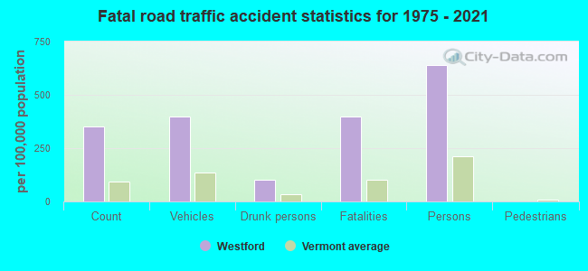
Westford fatal accident list:
May 13, 2005 07:00 PM, Fas-276, Lat: 44.638820, Lon: -73.101640, Vehicles: 1, Persons: 1, Fatalities: 1, Drunk persons involved: 1
Apr 20, 2003 01:35 AM, Sr-128, Vehicles: 1, Persons: 2, Fatalities: 2
Mar 22, 2001 09:10 PM, Sr-128, Vehicles: 2, Persons: 3, Fatalities: 1
Aug 28, 2000 10:48 PM, Sr-128, Vehicles: 1, Persons: 4, Fatalities: 1
Oct 16, 1993 04:25 PM, Vt128, Vehicles: 1, Persons: 1, Fatalities: 1, Drunk persons involved: 1
Jan 12, 1989 11:40 PM, Th 6, Vehicles: 1, Persons: 1, Fatalities: 1
- National Bridge Inventory (NBI) Statistics
- 4Number of bridges
- 23ft / 6.8mTotal length
- $1,326,000Total costs
- 9,110Total average daily traffic
- 1,280Total average daily truck traffic
- 9,566Total future (year 2028) average daily traffic
FCC Registered Microwave Towers:
1- VTEJ17b, 39 Orchard Lane (Lat: 44.613250 Lon: -73.037806), Type: Tower, Structure height: 33.5 m, Call Sign: WQJY658,
Assigned Frequencies: 10775.0 MHz, Grant Date: 02/18/2009, Expiration Date: 02/18/2019, Cancellation Date: 04/20/2010, Certifier: Shirley J Linn, Registrant: Latham & Watkins LLP, 555 Eleventh Street, Nw, Suite 1000, Washington, DC 20004-1304, Phone: (202) 637-2200, Fax: (202) 637-2201, Email:
FCC Registered Amateur Radio Licenses:
22 (See the full list of FCC Registered Amateur Radio Licenses in Westford)FAA Registered Aircraft:
1- Aircraft: CESSNA 172M (Category: Land, Seats: 4, Weight: Up to 12,499 Pounds, Speed: 108 mph), Engine: LYCOMING 0-320 SERIES (180 HP) (4 Cycle)
N-Number: 3TN, N3TN, N-3TN, Serial Number: 17263547, Year manufactured: 1974, Airworthiness Date: 07/15/1974, Certificate Issue Date: 07/31/2001
Registrant (LLC): Champlain Flyers LLC, 150 Mountain Rd, Westford, VT 05494
2002 - 2018 National Fire Incident Reporting System (NFIRS) incidents
- Fire incident types reported to NFIRS in Westford, VT
- 11059.1%Structure Fires
- 4624.7%Outside Fires
- 2614.0%Mobile Property/Vehicle Fires
- 42.2%Other
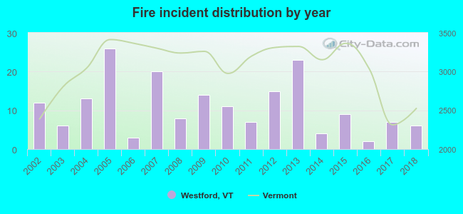 Based on the data from the years 2002 - 2018 the average number of fire incidents per year is 11. The highest number of reported fire incidents - 26 took place in 2005, and the least - 2 in 2016. The data has a decreasing trend.
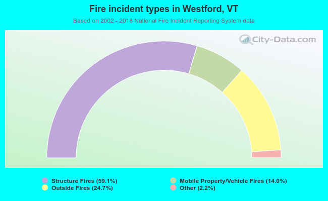 When looking into fire subcategories, the most incidents belonged to: Structure Fires (59.1%), and Outside Fires (24.7%).
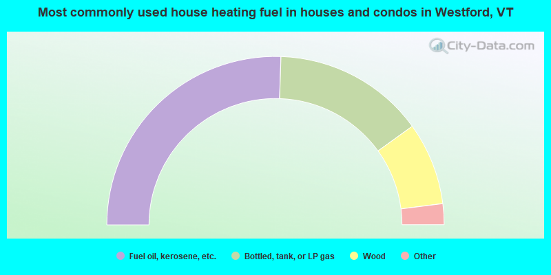
- 51.1%Fuel oil, kerosene, etc.
- 29.1%Bottled, tank, or LP gas
- 15.9%Wood
- 2.1%Utility gas
- 1.1%Other fuel
- 0.5%Electricity
- 0.3%Coal or coke
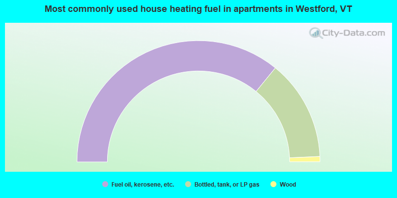
- 71.8%Fuel oil, kerosene, etc.
- 26.8%Bottled, tank, or LP gas
- 1.4%Wood
Westford compared to Vermont state average:
- Median household income above state average.
- Unemployed percentage significantly below state average.
- Black race population percentage significantly below state average.
- Hispanic race population percentage below state average.
- Median age below state average.
- Renting percentage significantly below state average.
- Length of stay since moving in significantly above state average.
- Number of rooms per house significantly below state average.
- House age significantly below state average.
- Number of college students below state average.

|
|
Total of 385 patent applications in 2008-2024.