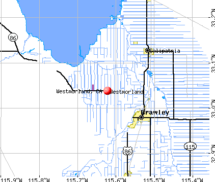
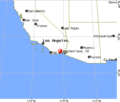
Westmorland, California
Submit your own pictures of this city and show them to the world
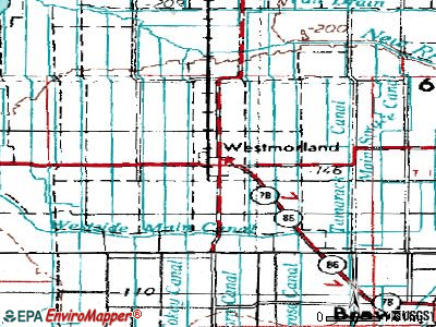
- OSM Map
- General Map
- Google Map
- MSN Map
Population change since 2000: -6.6%
 |
| Males: 941 | |
| Females: 1,049 |
| Median resident age: | 23.1 years |
| California median age: | 37.9 years |
Zip codes: 92281.
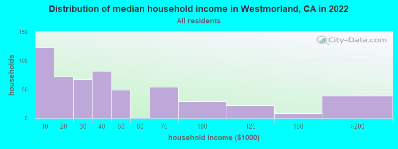
| Westmorland: | $33,874 |
| CA: | $91,551 |
Estimated per capita income in 2022: $13,855 (it was $8,941 in 2000)
Westmorland city income, earnings, and wages data
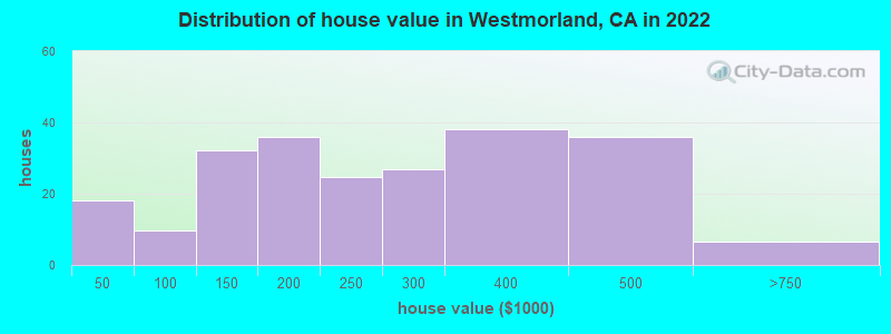
Estimated median house or condo value in 2022: $201,690 (it was $83,600 in 2000)
| Westmorland: | $201,690 |
| CA: | $715,900 |
Mean prices in 2022: all housing units: $244,754; detached houses: $244,459
Median gross rent in 2022: $823.
(42.1% for White Non-Hispanic residents, 50.6% for Hispanic or Latino residents, 48.0% for other race residents, 32.1% for two or more races residents)
Detailed information about poverty and poor residents in Westmorland, CA
Compare current foreclosures near Westmorland, CA:
| Photo | Address | Area | Beds / Baths | Price | Details |
|---|---|---|---|---|---|

|
#1
E 2nd St
Imperial, CA 92251
|
- sq. feet
|
2 baths 3 beds |
show details | |

|
#2
Blooming Canyon Way
Brawley, CA 92227
|
1,563 sq. feet
|
- baths - beds |
show details | |

|
#3
Rose Ave
El Centro, CA 92243
|
- sq. feet
|
1 baths 3 beds |
show details | |

|
#4
N 18th St
El Centro, CA 92243
|
- sq. feet
|
2 baths 4 beds |
show details | |

|
#5
S Imperial Ave
Brawley, CA 92227
|
- sq. feet
|
2 baths 3 beds |
show details | |

|
#6
W D St Apt A
Brawley, CA 92227
|
- sq. feet
|
- baths - beds |
show details | |

|
#7
W Pico Ave
El Centro, CA 92243
|
- sq. feet
|
- baths - beds |
show details | |

|
#8
N Imperial Ave Apt 23a
El Centro, CA 92243
|
- sq. feet
|
- baths - beds |
show details | |

|
#9
Sylvia Ct
Imperial, CA 92251
|
- sq. feet
|
- baths - beds |
show details | |

|
#10
W Nuevo Vallarta Dr
Imperial, CA 92251
|
- sq. feet
|
- baths - beds |
show details |
| Photo | Address | Area | Beds / Baths | Price | Details |
|---|---|---|---|---|---|

|
#11
La Paz Dr
Imperial, CA 92251
|
- sq. feet
|
- baths - beds |
show details | |

|
#12
Dulles Dr
Imperial, CA 92251
|
- sq. feet
|
- baths - beds |
show details | |

|
#13
Saddleback Dr
Imperial, CA 92251
|
- sq. feet
|
- baths - beds |
show details | |

|
#14
Garnet St
Imperial, CA 92251
|
- sq. feet
|
- baths - beds |
show details | |

|
#15
W Barioni Blvd # 215
Imperial, CA 92251
|
- sq. feet
|
- baths - beds |
show details | |

|
#16
N Imperial Ave Apt 8
Brawley, CA 92227
|
- sq. feet
|
- baths - beds |
show details | |

|
#17
Shoshonean Dr
Imperial, CA 92251
|
- sq. feet
|
- baths - beds |
show details | |

|
#18
W Bonita St
Calipatria, CA 92233
|
- sq. feet
|
- baths - beds |
show details | |

|
#19
Flammang Ave
Brawley, CA 92227
|
- sq. feet
|
- baths - beds |
show details | |

|
#20
Shoshonean Dr
Imperial, CA 92251
|
- sq. feet
|
- baths - beds |
show details |
| Photo | Address | Area | Beds / Baths | Price | Details |
|---|---|---|---|---|---|

|
#21
Tamarisk St
Imperial, CA 92251
|
- sq. feet
|
- baths - beds |
show details | |

|
#22
Ash St
Brawley, CA 92227
|
- sq. feet
|
- baths - beds |
show details | |

|
#23
N 18th St
El Centro, CA 92243
|
- sq. feet
|
- baths - beds |
show details | |

|
#24
W C St
Brawley, CA 92227
|
- sq. feet
|
- baths - beds |
show details | |

|
#25
Robert Noriega St
Brawley, CA 92227
|
- sq. feet
|
- baths - beds |
show details | |

|
#26
N G St # 102
Imperial, CA 92251
|
- sq. feet
|
- baths - beds |
show details | |

|
#27
Mesquite St
Imperial, CA 92251
|
- sq. feet
|
- baths - beds |
show details | |

|
#28
De Anza Pl
Brawley, CA 92227
|
- sq. feet
|
- baths - beds |
show details | |

|
#29
La Guardia Ct
Imperial, CA 92251
|
- sq. feet
|
- baths - beds |
show details | |

|
#30
I St
Brawley, CA 92227
|
- sq. feet
|
- baths - beds |
show details |
| Photo | Address | Area | Beds / Baths | Price | Details |
|---|---|---|---|---|---|

|
#31
I St
Brawley, CA 92227
|
- sq. feet
|
- baths - beds |
show details | |

|
#32
Cinnabar St
Imperial, CA 92251
|
- sq. feet
|
- baths - beds |
show details | |

|
#33
Crest View Dr
Brawley, CA 92227
|
- sq. feet
|
- baths - beds |
show details | |

|
Check over 1 million property listings on Foreclosure.com!
|
browse all offers | |||


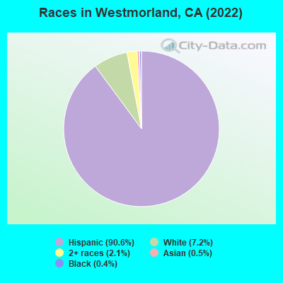
- 1,81290.6%Hispanic
- 1447.2%White alone
- 412.1%Two or more races
- 110.5%Asian alone
- 70.4%Black alone
According to our research of California and other state lists, there were 2 registered sex offenders living in Westmorland, California as of May 18, 2024.
The ratio of all residents to sex offenders in Westmorland is 1,019 to 1.
The ratio of registered sex offenders to all residents in this city is near the state average.
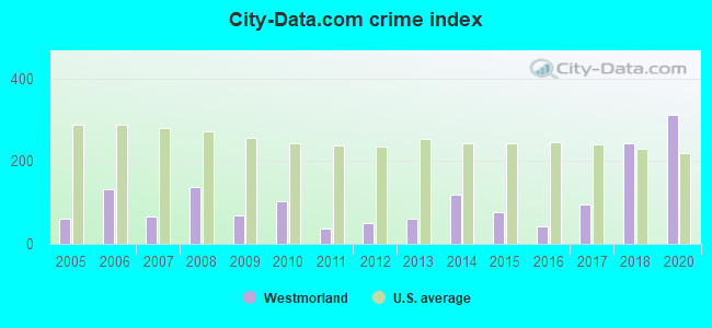
Type |
2009 |
2010 |
2011 |
2012 |
2013 |
2014 |
2015 |
2016 |
2017 |
2018 |
2020 |
|---|---|---|---|---|---|---|---|---|---|---|---|
| Murders (per 100,000) | 0 (0.0) | 0 (0.0) | 0 (0.0) | 0 (0.0) | 0 (0.0) | 0 (0.0) | 0 (0.0) | 0 (0.0) | 0 (0.0) | 1 (43.6) | 1 (44.3) |
| Rapes (per 100,000) | 0 (0.0) | 0 (0.0) | 0 (0.0) | 0 (0.0) | 1 (43.9) | 1 (44.2) | 0 (0.0) | 0 (0.0) | 0 (0.0) | 0 (0.0) | 0 (0.0) |
| Robberies (per 100,000) | 0 (0.0) | 1 (44.9) | 1 (44.4) | 1 (43.8) | 1 (43.9) | 2 (88.3) | 3 (131.7) | 0 (0.0) | 0 (0.0) | 0 (0.0) | 1 (44.3) |
| Assaults (per 100,000) | 1 (45.3) | 5 (224.7) | 0 (0.0) | 1 (43.8) | 0 (0.0) | 5 (220.8) | 2 (87.8) | 2 (87.9) | 5 (219.7) | 11 (480.1) | 12 (531.9) |
| Burglaries (per 100,000) | 10 (453.1) | 7 (314.6) | 4 (177.7) | 7 (306.7) | 2 (87.8) | 3 (132.5) | 5 (219.5) | 4 (175.8) | 9 (395.4) | 6 (261.9) | 9 (398.9) |
| Thefts (per 100,000) | 6 (271.9) | 8 (359.6) | 7 (311.0) | 1 (43.8) | 4 (175.5) | 0 (0.0) | 2 (87.8) | 3 (131.9) | 10 (439.4) | 21 (916.6) | 31 (1,374) |
| Auto thefts (per 100,000) | 5 (226.6) | 2 (89.9) | 0 (0.0) | 1 (43.8) | 0 (0.0) | 1 (44.2) | 0 (0.0) | 2 (87.9) | 2 (87.9) | 1 (43.6) | 6 (266.0) |
| Arson (per 100,000) | 0 (0.0) | 0 (0.0) | 0 (0.0) | 0 (0.0) | 0 (0.0) | 0 (0.0) | 0 (0.0) | 0 (0.0) | 0 (0.0) | 1 (43.6) | 0 (0.0) |
| City-Data.com crime index | 69.8 | 102.0 | 38.2 | 48.6 | 61.4 | 118.8 | 75.9 | 42.2 | 96.2 | 241.8 | 312.5 |
The City-Data.com crime index weighs serious crimes and violent crimes more heavily. Higher means more crime, U.S. average is 246.1. It adjusts for the number of visitors and daily workers commuting into cities.
Crime rate in Westmorland detailed stats: murders, rapes, robberies, assaults, burglaries, thefts, arson
Full-time law enforcement employees in 2021, including police officers: 3 (3 officers - 3 male; 0 female).
| Officers per 1,000 residents here: | 1.34 |
| California average: | 2.30 |
 Recent articles from our blog. Our writers, many of them Ph.D. graduates or candidates, create easy-to-read articles on a wide variety of topics.

 | Imperial Valley / Mexicali (10 replies) |
| So... Where would YOU rather live in SoCal? (18 replies) |
| Give me more info on the cities/CDPs in the Imperial Valley? (6 replies) |
| Imperial County 1950's...(Westmorland, Brawley) (2 replies) |
| "NorCal" vs "SoCal": False dichotomy? (42 replies) |
| Earthquake? (42 replies) |
Latest news from Westmorland, CA collected exclusively by city-data.com from local newspapers, TV, and radio stations
Ancestries: American (2.6%), Irish (1.9%).
Current Local Time: PST time zone
Elevation: -159 feet
Land area: 0.40 square miles.
Population density: 4,915 people per square mile (average).
745 residents are foreign born (36.6% Latin America).
| This city: | 37.2% |
| California: | 26.5% |
Median real estate property taxes paid for housing units with mortgages in 2022: $2,229 (1.1%)
Median real estate property taxes paid for housing units with no mortgage in 2022: $1,218 (0.5%)
Nearest city with pop. 50,000+: Coachella Valley, CA  (52.4 miles , pop. 118,932).
Nearest city with pop. 200,000+: San Diego, CA (90.3 miles , pop. 1,223,400).
Nearest cities:
), ), )Latitude: 33.04 N, Longitude: 115.62 W
Area code commonly used in this area: 760

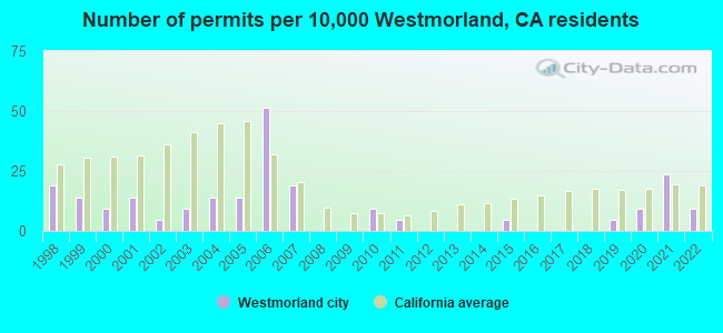
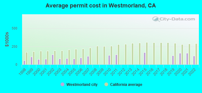
Single-family new house construction building permits:
- 2022: 2 buildings, average cost: $119,100
- 2021: 5 buildings, average cost: $159,400
- 2020: 2 buildings, average cost: $160,000
- 2019: 1 building, cost: $125,000
- 2015: 1 building, cost: $167,200
- 2011: 1 building, cost: $134,500
- 2010: 2 buildings, average cost: $128,800
- 2007: 4 buildings, average cost: $114,400
- 2006: 11 buildings, average cost: $96,100
- 2005: 3 buildings, average cost: $81,700
- 2004: 3 buildings, average cost: $85,900
- 2003: 2 buildings, average cost: $81,500
- 2002: 1 building, cost: $137,500
- 2001: 3 buildings, average cost: $76,100
- 2000: 2 buildings, average cost: $73,100
- 1999: 3 buildings, average cost: $104,700
- 1998: 4 buildings, average cost: $55,300
| Here: | 18.3% |
| California: | 5.1% |
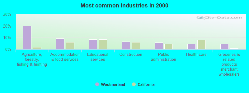
- Agriculture, forestry, fishing & hunting (20.3%)
- Accommodation & food services (9.3%)
- Educational services (8.5%)
- Construction (6.8%)
- Public administration (5.9%)
- Health care (4.6%)
- Groceries & related products merchant wholesalers (4.4%)
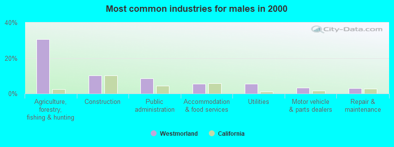
- Agriculture, forestry, fishing & hunting (30.7%)
- Construction (10.3%)
- Public administration (8.6%)
- Accommodation & food services (5.7%)
- Utilities (5.4%)
- Motor vehicle & parts dealers (3.4%)
- Repair & maintenance (2.9%)
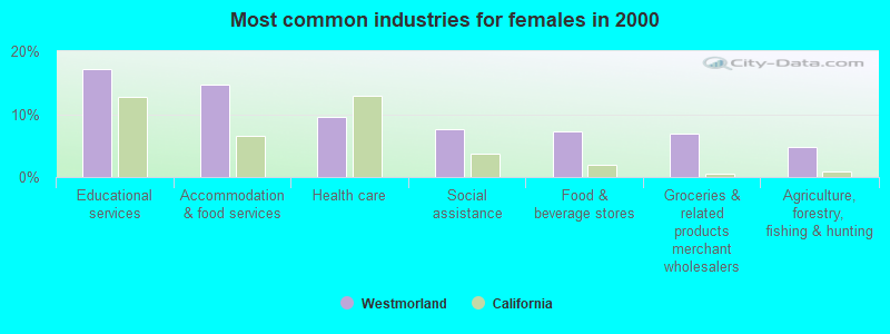
- Educational services (17.2%)
- Accommodation & food services (14.7%)
- Health care (9.5%)
- Social assistance (7.7%)
- Food & beverage stores (7.3%)
- Groceries & related products merchant wholesalers (7.0%)
- Agriculture, forestry, fishing & hunting (4.8%)
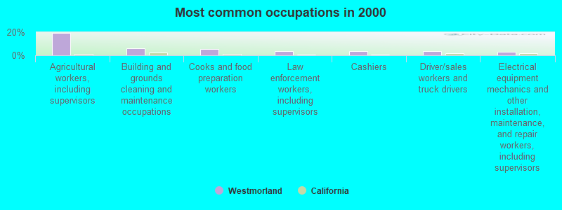
- Agricultural workers, including supervisors (19.3%)
- Building and grounds cleaning and maintenance occupations (6.2%)
- Cooks and food preparation workers (5.3%)
- Law enforcement workers, including supervisors (3.8%)
- Cashiers (3.8%)
- Driver/sales workers and truck drivers (3.5%)
- Electrical equipment mechanics and other installation, maintenance, and repair workers, including supervisors (3.2%)
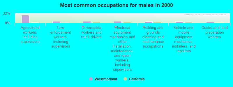
- Agricultural workers, including supervisors (25.8%)
- Law enforcement workers, including supervisors (6.1%)
- Driver/sales workers and truck drivers (5.9%)
- Electrical equipment mechanics and other installation, maintenance, and repair workers, including supervisors (5.4%)
- Building and grounds cleaning and maintenance occupations (4.9%)
- Vehicle and mobile equipment mechanics, installers, and repairers (4.7%)
- Cooks and food preparation workers (4.2%)
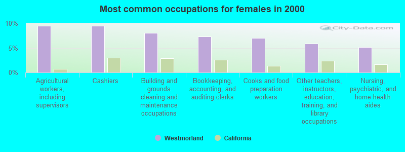
- Agricultural workers, including supervisors (9.5%)
- Cashiers (9.5%)
- Building and grounds cleaning and maintenance occupations (8.1%)
- Bookkeeping, accounting, and auditing clerks (7.3%)
- Cooks and food preparation workers (7.0%)
- Other teachers, instructors, education, training, and library occupations (5.9%)
- Nursing, psychiatric, and home health aides (5.1%)
Average climate in Westmorland, California
Based on data reported by over 4,000 weather stations


|
|

(lower is better)
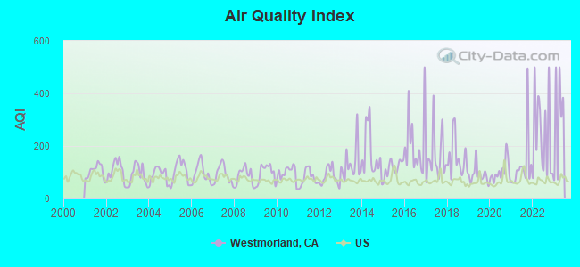
Air Quality Index (AQI) level in 2022 was 238. This is significantly worse than average.
| City: | 238 |
| U.S.: | 73 |
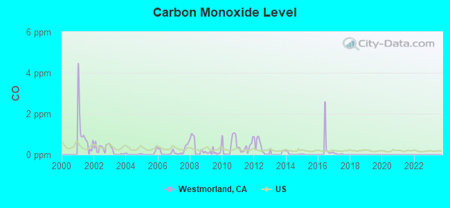
Carbon Monoxide (CO) [ppm] level in 2017 was 0.0323. This is significantly better than average. Closest monitor was 17.3 miles away from the city center.
| City: | 0.0323 |
| U.S.: | 0.2513 |
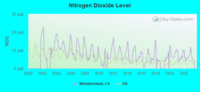
Nitrogen Dioxide (NO2) [ppb] level in 2022 was 6.85. This is worse than average. Closest monitor was 17.3 miles away from the city center.
| City: | 6.85 |
| U.S.: | 5.11 |
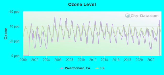
Ozone [ppb] level in 2022 was 23.1. This is significantly better than average. Closest monitor was 0.4 miles away from the city center.
| City: | 23.1 |
| U.S.: | 33.3 |
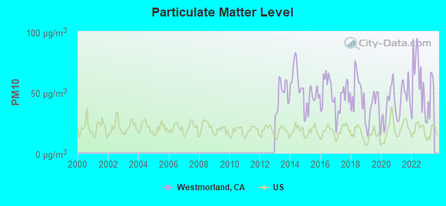
Particulate Matter (PM10) [µg/m3] level in 2022 was 59.9. This is significantly worse than average. Closest monitor was 0.4 miles away from the city center.
| City: | 59.9 |
| U.S.: | 19.2 |
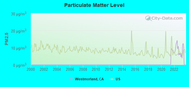
Particulate Matter (PM2.5) [µg/m3] level in 2022 was 8.96. This is about average. Closest monitor was 6.3 miles away from the city center.
| City: | 8.96 |
| U.S.: | 8.11 |
Earthquake activity:
Westmorland-area historical earthquake activity is significantly above California state average. It is 5647% greater than the overall U.S. average.On 6/28/1992 at 11:57:34, a magnitude 7.6 (6.2 MB, 7.6 MS, 7.3 MW, Depth: 0.7 mi, Class: Major, Intensity: VIII - XII) earthquake occurred 95.0 miles away from Westmorland center, causing 3 deaths (1 shaking deaths, 2 other deaths) and 400 injuries, causing $100,000,000 total damage and $40,000,000 insured losses
On 5/19/1940 at 04:36:40, a magnitude 7.2 (7.2 UK) earthquake occurred 13.4 miles away from Westmorland center, causing $33,000,000 total damage
On 12/31/1934 at 18:45:56, a magnitude 7.1 (7.1 UK) earthquake occurred 25.7 miles away from Westmorland center
On 10/16/1999 at 09:46:44, a magnitude 7.4 (6.3 MB, 7.4 MS, 7.2 MW, 7.3 ML) earthquake occurred 112.3 miles away from the city center
On 10/15/1979 at 23:16:54, a magnitude 7.0 (5.7 MB, 6.9 MS, 7.0 ML, 6.4 MW) earthquake occurred 15.4 miles away from Westmorland center
On 7/21/1952 at 11:52:14, a magnitude 7.7 (7.7 UK) earthquake occurred 236.4 miles away from the city center, causing $50,000,000 total damage
Magnitude types: body-wave magnitude (MB), local magnitude (ML), surface-wave magnitude (MS), moment magnitude (MW)
Natural disasters:
The number of natural disasters in Imperial County (10) is smaller than the US average (15).Major Disasters (Presidential) Declared: 8
Emergencies Declared: 1
Causes of natural disasters: Floods: 5, Winter Storms: 3, Earthquakes: 2, Landslides: 2, Freeze: 1, Hurricane: 1, Storm: 1, Tropical Storm: 1, Other: 1 (Note: some incidents may be assigned to more than one category).
Hospitals and medical centers near Westmorland:
- IMPERIAL HEIGHTS HEALTHCARE AND WELLNESS CENTRE, LLC (Nursing Home, about 7 miles away; BRAWLEY, CA)
- ROYAL CONV HOSP (Nursing Home, about 7 miles away; BRAWLEY, CA)
- QUALITY HOME PROFESSIONALS (Home Health Center, about 7 miles away; BRAWLEY, CA)
- FMC-BRAWLEY (Dialysis Facility, about 7 miles away; BRAWLEY, CA)
- IMPERIAL VALLEY HOME HEALTH CARE CORPORATION (Home Health Center, about 7 miles away; BRAWLEY, CA)
- PIONEERS MEMORIAL HEALTHCARE DISTRICT Acute Care Hospitals (about 7 miles away; BRAWLEY, CA)
- IMPERIAL MANOR (Nursing Home, about 14 miles away; IMPERIAL, CA)
Colleges/universities with over 2000 students nearest to Westmorland:
- Imperial Valley College (about 17 miles; Imperial, CA; Full-time enrollment: 5,313)
- College of the Desert (about 66 miles; Palm Desert, CA; FT enrollment: 5,686)
- Arizona Western College (about 70 miles; Yuma, AZ; FT enrollment: 5,454)
- Cuyamaca College (about 80 miles; El Cajon, CA; FT enrollment: 4,270)
- Grossmont College (about 82 miles; El Cajon, CA; FT enrollment: 10,461)
- Southwestern College (about 85 miles; Chula Vista, CA; FT enrollment: 10,761)
- Alliant International University (about 86 miles; San Diego, CA; FT enrollment: 3,155)
Private high school in Westmorland:
Public elementary/middle school in Westmorland:
- WESTMORLAND ELEMENTARY (Students: 252, Location: 200 S. C ST., Grades: KG-8)
Points of interest:
Notable locations in Westmorland: Westmorland Fire Department (A), Westmorland City Hall (B). Display/hide their locations on the map
Park in Westmorland: Westmorland City Park (1). Display/hide its location on the map
Birthplace of: Justin Lofton - Stock car racing driver.
| This city: | 3.5 people |
| California: | 2.9 people |
| This city: | 84.6% |
| Whole state: | 68.7% |
| This city: | 10.3% |
| Whole state: | 7.2% |
Likely homosexual households (counted as self-reported same-sex unmarried-partner households)
- Lesbian couples: 0.3% of all households
- Gay men: 0.3% of all households
For population 15 years and over in Westmorland:
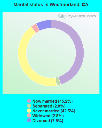
- Never married: 42.5%
- Now married: 45.2%
- Separated: 2.0%
- Widowed: 2.8%
- Divorced: 7.5%
For population 25 years and over in Westmorland:
- High school or higher: 57.2%
- Bachelor's degree or higher: 6.1%
- Graduate or professional degree: 1.2%
- Unemployed: 18.8%
- Mean travel time to work (commute): 36.4 minutes

| Here: | 17.4 |
| California average: | 15.5 |
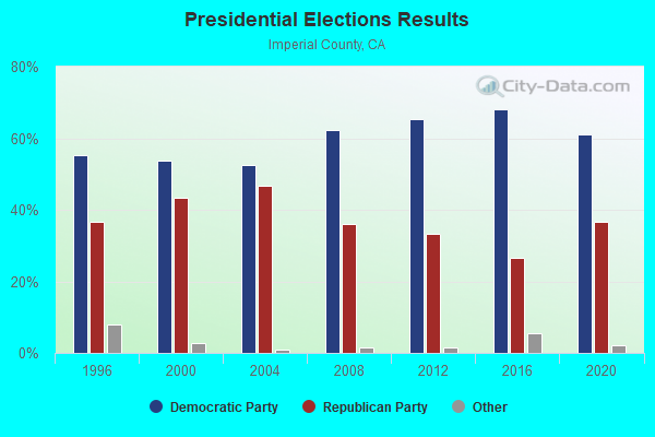
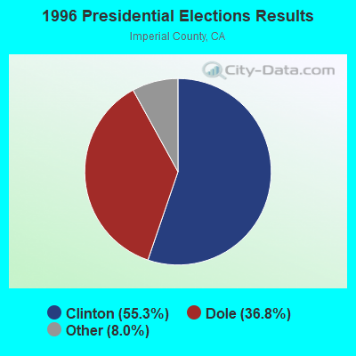
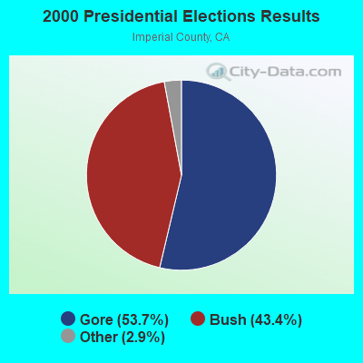
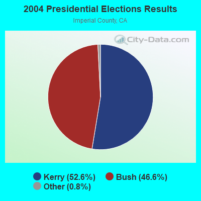
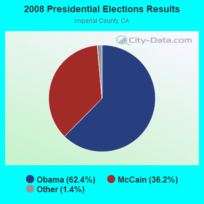
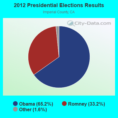
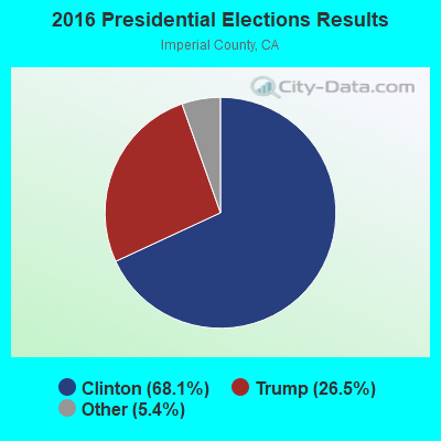
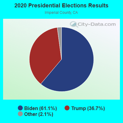
Graphs represent county-level data. Detailed 2008 Election Results
Religion statistics for Westmorland, CA (based on Imperial County data)
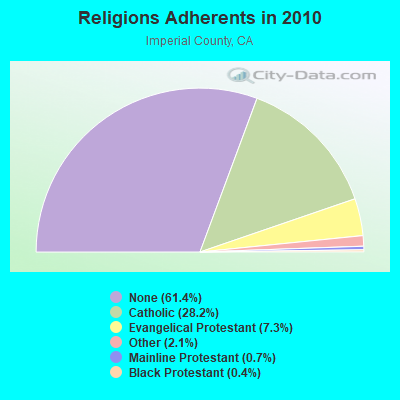
| Religion | Adherents | Congregations |
|---|---|---|
| Catholic | 49,226 | 12 |
| Evangelical Protestant | 12,707 | 80 |
| Other | 3,633 | 14 |
| Mainline Protestant | 1,137 | 12 |
| Black Protestant | 669 | 5 |
| None | 107,156 | - |
Food Environment Statistics:
| Imperial County: | 2.49 / 10,000 pop. |
| State: | 2.14 / 10,000 pop. |
| Imperial County: | 0.06 / 10,000 pop. |
| California: | 0.04 / 10,000 pop. |
| Imperial County: | 0.62 / 10,000 pop. |
| California: | 0.62 / 10,000 pop. |
| Imperial County: | 3.23 / 10,000 pop. |
| California: | 1.49 / 10,000 pop. |
| Here: | 4.85 / 10,000 pop. |
| California: | 7.42 / 10,000 pop. |
| This county: | 6.9% |
| California: | 7.3% |
| Imperial County: | 25.4% |
| California: | 21.3% |
| This county: | 16.6% |
| State: | 17.9% |
Health and Nutrition:
| This city: | 45.9% |
| California: | 49.4% |
| Westmorland: | 43.4% |
| State: | 48.0% |
| Westmorland: | 28.8 |
| State: | 28.1 |
| Westmorland: | 25.6% |
| California: | 20.2% |
| Westmorland: | 11.8% |
| California: | 11.2% |
| Here: | 6.8 |
| California: | 6.8 |
| Here: | 32.6% |
| State: | 31.5% |
| Westmorland: | 51.3% |
| California: | 56.4% |
| Westmorland: | 80.0% |
| California: | 80.9% |
More about Health and Nutrition of Westmorland, CA Residents
| Local government employment and payroll (March 2022) | |||||
| Function | Full-time employees | Monthly full-time payroll | Average yearly full-time wage | Part-time employees | Monthly part-time payroll |
|---|---|---|---|---|---|
| Police Protection - Officers | 3 | $41,811 | $167,244 | 0 | $0 |
| Water Supply | 2 | $10,775 | $64,650 | 0 | $0 |
| Sewerage | 1 | $8,417 | $101,004 | 1 | $177 |
| Other Government Administration | 1 | $3,790 | $45,480 | 6 | $1,750 |
| Fire - Other | 0 | $0 | 2 | $625 | |
| Financial Administration | 0 | $0 | 1 | $554 | |
| Housing and Community Development (Local) | 0 | $0 | 1 | $996 | |
| Streets and Highways | 0 | $0 | 1 | $271 | |
| Parks and Recreation | 0 | $0 | 1 | $2,267 | |
| Firefighters | 0 | $0 | 10 | $2,365 | |
| Totals for Government | 7 | $64,794 | $111,075 | 23 | $9,006 |
Westmorland government finances - Expenditure in 2017 (per resident):
- Current Operations - Regular Highways: $571,000 ($286.93)
Police Protection: $508,000 ($255.28)
Water Utilities: $353,000 ($177.39)
Central Staff Services: $290,000 ($145.73)
Sewerage: $261,000 ($131.16)
Solid Waste Management: $202,000 ($101.51)
Local Fire Protection: $60,000 ($30.15)
Parks and Recreation: $46,000 ($23.12)
Westmorland government finances - Revenue in 2017 (per resident):
- Charges - Sewerage: $316,000 ($158.79)
Solid Waste Management: $226,000 ($113.57)
Other: $95,000 ($47.74)
Parks and Recreation: $3,000 ($1.51)
- Federal Intergovernmental - Other: $612,000 ($307.54)
- Miscellaneous - General Revenue - Other: $96,000 ($48.24)
Rents: $11,000 ($5.53)
Interest Earnings: $5,000 ($2.51)
Fines and Forfeits: $5,000 ($2.51)
- Revenue - Water Utilities: $390,000 ($195.98)
- State Intergovernmental - Other: $717,000 ($360.30)
Highways: $53,000 ($26.63)
- Tax - General Sales and Gross Receipts: $439,000 ($220.60)
Property: $204,000 ($102.51)
Other Selective Sales: $62,000 ($31.16)
Other License: $29,000 ($14.57)
Public Utilities Sales: $13,000 ($6.53)
Other: $12,000 ($6.03)
Occupation and Business License - Other: $8,000 ($4.02)
Documentary and Stock Transfer: $2,000 ($1.01)
Westmorland government finances - Cash and Securities in 2017 (per resident):
- Other Funds - Cash and Securities: $3,170,000 ($1592.96)
Businesses in Westmorland, CA
- Circle K: 1
- True Value: 1
- U-Haul: 1
Strongest AM radio stations in Westmorland:
- KROP (1300 AM; 1 kW; BRAWLEY, CA; Owner: COMMONWEALTH LICENSE SUBSIDIARY, LLC)
- KFMB (760 AM; 50 kW; SAN DIEGO, CA; Owner: MIDWEST TELEVISION, INC.)
- KCBQ (1170 AM; 50 kW; SAN DIEGO, CA; Owner: RADIO 1210, INC.)
- KPLS (830 AM; 50 kW; ORANGE, CA; Owner: CRN LICENSES, LLC)
- KLAC (570 AM; 50 kW; LOS ANGELES, CA; Owner: AMFM RADIO LICENSES, L.L.C.)
- KFI (640 AM; 50 kW; LOS ANGELES, CA; Owner: CAPSTAR TX LIMITED PARTNERSHIP)
- KWST (1430 AM; 1 kW; EL CENTRO, CA; Owner: ENTRAVISION HOLDINGS, LLC)
- KXO (1230 AM; 1 kW; EL CENTRO, CA; Owner: KXO, INC.)
- KSPN (710 AM; 50 kW; LOS ANGELES, CA; Owner: KABC-AM RADIO, INC.)
- KTNQ (1020 AM; 50 kW; LOS ANGELES, CA; Owner: KTNQ-AM LICENSE CORP.)
- KPRZ (1210 AM; 20 kW; SAN MARCOS, CA; Owner: RADIO 1210, INC.)
- KXTA (1150 AM; 50 kW; LOS ANGELES, CA; Owner: CITICASTERS LICENSES, L.P.)
- KFWB (980 AM; 50 kW; LOS ANGELES, CA; Owner: INFINITY BROADCASTING OPERATIONS, INC.)
Strongest FM radio stations in Westmorland:
- KSSB (100.9 FM; CALIPATRIA, CA; Owner: PHILLIP J. PLANK)
- KSEH (94.5 FM; BRAWLEY, CA; Owner: ENTRAVISION HOLDINGS, LLC)
- KSIQ (96.1 FM; BRAWLEY, CA; Owner: COMMONWEALTH LICENSE SUBSIDIARY, LLC)
- KZAL (105.5 FM; DESERT CENTER, CA; Owner: WORLDWIDE MULTI-MEDIA B/C CO.)
- KMXX (99.3 FM; IMPERIAL, CA; Owner: ENTRAVISION HOLDINGS, LLC)
- KLVJ (100.1 FM; JULIAN, CA; Owner: EDUCATIONAL MEDIA FOUNDATION)
- KGBA (100.1 FM; HOLTVILLE, CA; Owner: THE VOICE OF INTERNATONAL CHRISTIAN EVANGELISM, INC.)
- KUBO (88.7 FM; CALEXICO, CA; Owner: RADIO BILINGUE, INC.)
TV broadcast stations around Westmorland:
- K56GC (Channel 56; EL CENTRO-HOLTVILLE, CA; Owner: INSPIRATION TELEVISION, INC.)

Westmorland fatal accident list:
Jan 20, 2002 11:18 AM, Sr-86, Vehicles: 2, Persons: 5, Fatalities: 1
Mar 8, 2002 06:42 PM, Center St, Vehicles: 1, Persons: 2, Pedestrians: 1, Fatalities: 1
Jun 25, 1983 06:20 PM, Vehicles: 1, Persons: 2, Fatalities: 1
- National Bridge Inventory (NBI) Statistics
- 5Number of bridges
- 30ft / 9.2mTotal length
- $670,000Total costs
- 12,660Total average daily traffic
- 3,327Total average daily truck traffic
- 22,210Total future (year 2038) average daily traffic
FCC Registered Antenna Towers:
10 (See the full list of FCC Registered Antenna Towers in Westmorland)FCC Registered Broadcast Land Mobile Towers:
2- 230 W. Main St (Lat: 33.037444 Lon: -115.623583), Type: Tower, Structure height: 12 m, Overall height: 14 m, Call Sign: WPXN812,
Assigned Frequencies: 155.010 MHz, Grant Date: 05/13/2003, Expiration Date: 05/13/2013, Cancellation Date: 07/13/2013, Certifier: Fred R Beltran, Registrant: Business Radio Licensing, 26941 Cabot Rd #134, Laguna Hills, CA 92653, Phone: (949) 348-8510, Fax: (949) 348-8514
- Lat: 33.038333 Lon: -115.618611, Call Sign: WQTN849,
Assigned Frequencies: 464.375 MHz, 464.762 MHz, 464.662 MHz, 464.062 MHz, 464.237 MHz, Grant Date: 03/14/2014, Expiration Date: 03/14/2024, Certifier: Nancy Johnson, Registrant: Haggerty Communictions Group, Jamul, CA 91935, Phone: (619) 468-3809, Email:
FCC Registered Microwave Towers:
10 (See the full list of FCC Registered Microwave Towers in this town)FCC Registered Amateur Radio Licenses:
6- Call Sign: KB6JNW, Licensee ID: L00235024, Grant Date: 05/04/1995, Expiration Date: 05/04/2005, Cancellation Date: 03/11/2003, Certifier: Joseph F Rigley Sr, Registrant: Joseph F Rigley Sr, Westmorland, CA 92281
- Call Sign: N6RHN, Previous Call Sign: KA6EOE, Licensee ID: L00305726, Grant Date: 10/11/2011, Expiration Date: 11/13/2021, Cancellation Date: 11/14/2023, Certifier: James D Walker, Registrant: James D Walker, Westmorland, CA 92281
- Call Sign: KG6BHC, Licensee ID: L00235024, Grant Date: 05/03/2000, Expiration Date: 05/03/2010, Cancellation Date: 05/04/2012, Certifier: Joseph F Rigley, Registrant: Joseph F Rigley, Westmorland, CA 92281
- Call Sign: KI6SIN, Licensee ID: L01419640, Grant Date: 07/12/2018, Expiration Date: 07/28/2028, Certifier: Andres A Cruz, Registrant: Andres A Cruz, Westmorland, CA 92281
- Call Sign: KI6SIO, Licensee ID: L01419641, Grant Date: 06/27/2018, Expiration Date: 07/28/2028, Certifier: Sergio Cruz, Registrant: Sergio Cruz, Westmorland, CA 92281
- Call Sign: KI6SIR, Licensee ID: L01419644, Grant Date: 06/27/2018, Expiration Date: 07/28/2028, Certifier: David C Ford, Registrant: David C Ford, Westmorland, CA 92281
FAA Registered Aircraft:
2- Aircraft: CESSNA 182P (Category: Land, Seats: 4, Weight: Up to 12,499 Pounds, Speed: 120 mph), Engine: CONT MOTOR O-470 SERIES (230 HP) (Reciprocating)
N-Number: 21196, N21196, N-21196, Serial Number: 18261478, Year manufactured: 1972, Airworthiness Date: 11/03/1972, Certificate Issue Date: 01/25/1984
Registrant (Individual): Richard J Ashurst, Po Box 58, Westmorland, CA 92281 - Aircraft: RYAN NAVION B (Category: Land, Seats: 5, Weight: Up to 12,499 Pounds, Speed: 126 mph), Engine: CONT MOTOR I0-470 SERIES (260 HP) (Reciprocating)
N-Number: 2893D, N2893D, N-2893D, Serial Number: 2242B, Year manufactured: 1951, Airworthiness Date: 11/14/1956, Certificate Issue Date: 11/07/2017
Registrant (Co-Owned): Brent H Ashurst, Po Box 722, Westmorland, CA 92281, Other Owners: Carly Ashurst
2005 - 2018 National Fire Incident Reporting System (NFIRS) incidents
- Fire incident types reported to NFIRS in Westmorland, CA
- 6743.8%Outside Fires
- 5133.3%Structure Fires
- 2013.1%Mobile Property/Vehicle Fires
- 159.8%Other
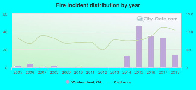 Based on the data from the years 2005 - 2018 the average number of fires per year is 11. The highest number of reported fire incidents - 47 took place in 2015, and the least - 0 in 2009. The data has a rising trend.
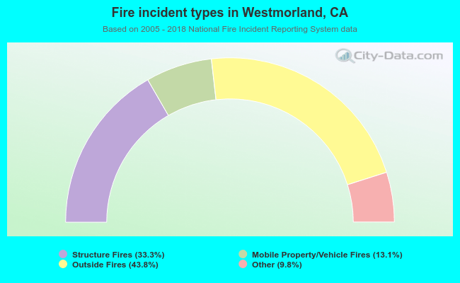 When looking into fire subcategories, the most incidents belonged to: Outside Fires (43.8%), and Structure Fires (33.3%).
| Most common first names in Westmorland, CA among deceased individuals | ||
| Name | Count | Lived (average) |
|---|---|---|
| William | 12 | 72.4 years |
| Jose | 8 | 72.2 years |
| Jesus | 7 | 73.9 years |
| John | 7 | 74.7 years |
| Manuel | 7 | 56.4 years |
| Mary | 7 | 81.9 years |
| James | 5 | 67.8 years |
| Maria | 5 | 72.2 years |
| Robert | 5 | 64.8 years |
| Henry | 4 | 75.0 years |
| Most common last names in Westmorland, CA among deceased individuals | ||
| Last name | Count | Lived (average) |
|---|---|---|
| Garcia | 12 | 63.0 years |
| Freeman | 8 | 78.8 years |
| Gutierrez | 6 | 52.5 years |
| Brummett | 5 | 81.8 years |
| Hall | 5 | 78.6 years |
| Perez | 5 | 72.4 years |
| Gonzalez | 4 | 82.5 years |
| Holden | 4 | 64.2 years |
| Curiel | 4 | 55.8 years |
| Uyechi | 4 | 84.7 years |
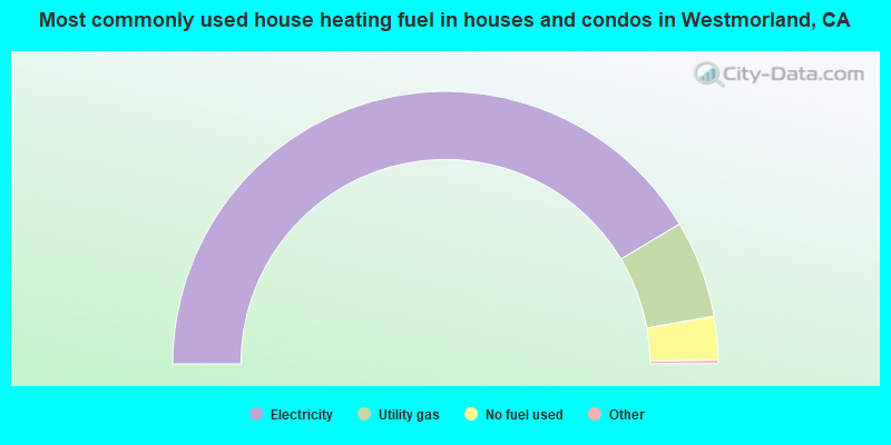
- 83.3%Electricity
- 11.6%Utility gas
- 5.2%No fuel used
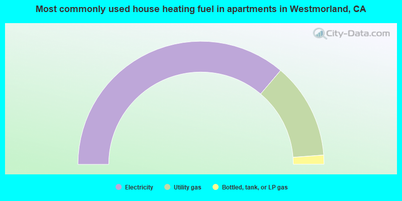
- 72.4%Electricity
- 25.2%Utility gas
- 2.4%Bottled, tank, or LP gas
Westmorland compared to California state average:
- Median household income significantly below state average.
- Median house value significantly below state average.
- Black race population percentage significantly below state average.
- Hispanic race population percentage above state average.
- Length of stay since moving in significantly below state average.
- Number of college students below state average.
- Percentage of population with a bachelor's degree or higher significantly below state average.
State forum archive:
- California Pages: 2 3 4 5 6 7 8 9 10 11 12 13 14 15 16 17 18 19 20 21 22 23 24 25 26 27 28 29 30 31 32 33 34 35 36 37 38 39 40 41 42 43 44 45 46 47 48 49 50 51 52 53 54 55 56 57 58 59 60 61 62 63 64 65 66 67 68 69 70 71 72 73 74 75 76 77 78 79
- Los Angeles Pages: 2 3 4 5 6 7 8 9 10 11 12 13 14 15 16 17 18 19 20 21 22 23 24 25 26 27 28 29 30 31 32 33 34 35 36 37 38 39 40 41 42 43 44 45 46 47 48 49 50 51 52 53 54 55 56 57 58 59 60 61 62 63 64 65 66 67 68 69 70 71 72 73 74 75 76 77 78 79 80 81 82 83 84 85 86 87 88 89 90 91 92 93 94 95 96 97 98 99 100 101 102 103 104 105 106 107 108 109 110 111 112 113 114 115 116 117 118 119 120 121 122 123
- Monterey County Pages: 2 3
- Orange County Pages: 2 3 4 5 6 7 8 9 10 11 12 13 14 15 16 17 18 19 20 21 22 23 24 25 26 27 28 29 30 31 32 33 34 35 36
- Sacramento Pages: 2 3 4 5 6 7 8 9 10 11 12 13 14 15 16 17 18 19 20 21 22 23 24 25 26 27 28 29 30 31 32
- San Bernardino and Riverside Counties Pages: 2 3 4 5 6 7 8 9 10 11 12 13 14 15 16 17 18 19 20 21 22 23
- San Diego Pages: 2 3 4 5 6 7 8 9 10 11 12 13 14 15 16 17 18 19 20 21 22 23 24 25 26 27 28 29 30 31 32 33 34 35 36 37 38 39 40 41 42 43 44 45 46 47 48 49 50 51 52 53 54 55 56 57 58 59 60 61 62 63 64 65 66 67 68 69 70 71 72 73 74 75 76
- San Francisco - Oakland Pages: 2 3 4 5 6 7 8 9 10 11 12 13 14 15 16 17 18 19 20 21 22 23 24 25 26 27 28 29 30 31 32 33 34 35 36 37 38 39 40 41 42 43 44 45 46 47 48 49 50 51 52 53 54 55 56 57 58 59 60 61 62 63 64 65 66 67 68 69 70 71 72
- San Jose Pages: 2 3 4 5 6 7 8 9 10 11 12 13 14 15 16 17 18 19 20 21 22 23 24
- Ventura County Pages: 2 3 4 5 6 7