Please register to participate in our discussions with 2 million other members - it's free and quick! Some forums can only be seen by registered members. After you create your account, you'll be able to customize options and access all our 15,000 new posts/day with fewer ads.
Hello. I am looking for a bit of insight / description of the Hwy 12 corridor, La Veta to Trinidad, have not found much info in the forum. Seeking some mountain solitude, not extreme (a few little towns are ideal), but certainly do not mind being the only vehicle at the trail head!
I dug up some information on the former Panadero ski area, and it's sales turn-over from one Texan to the next, over and over! I can see how the "resort" town of Cuchara popped up on the vision of a feasible ski hill, and I am going out on a limb that this is a Texan summer town.
For those who have some experience with this area, please offer some comments...does it hold the old school Colorado experience, like the San Luis Valley? Is it over the top iso-feeling in the winter months? Does it still hold a low-key charm in the summer months?
Weather: does this valley get the Chinook effect from the Sangre's? I went through the weather underground local data from last winter and was surprised that the temps were a bit higher than expected.
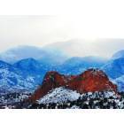
Sangre de Cristos: this is the range that I know nothing about, comments from the recreation side?
My goal is to find a nice escape to enjoy some serene recreation, snow shoe, hike, run the dogs, mountain bike. Does the Highway 12 corridor offer this experience? Key benefits and drawbacks?
Some of the usual suspects have a lot of Colorado experience and usually helpful thoughts/opinions. All ears...
Hello. I am looking for a bit of insight / description of the Hwy 12 corridor, La Veta to Trinidad, have not found much info in the forum. Seeking some mountain solitude, not extreme (a few little towns are ideal), but certainly do not mind being the only vehicle at the trail head!
I dug up some information on the former Panadero ski area, and it's sales turn-over from one Texan to the next, over and over! I can see how the "resort" town of Cuchara popped up on the vision of a feasible ski hill, and I am going out on a limb that this is a Texan summer town.
For those who have some experience with this area, please offer some comments...does it hold the old school Colorado experience, like the San Luis Valley? Is it over the top iso-feeling in the winter months? Does it still hold a low-key charm in the summer months?
Weather: does this valley get the Chinook effect from the Sangre's? I went through the weather underground local data from last winter and was surprised that the temps were a bit higher than expected.
Sangre de Cristos: this is the range that I know nothing about, comments from the recreation side?
My goal is to find a nice escape to enjoy some serene recreation, snow shoe, hike, run the dogs, mountain bike. Does the Highway 12 corridor offer this experience? Key benefits and drawbacks?
Some of the usual suspects have a lot of Colorado experience and usually helpful thoughts/opinions. All ears...
I can only comment on the San Luis Valley not the other. We almost bought some land there but found out that there are TREMENDOUS water restrictions that we could not live with. Also, bringing in electricity, if it is not readily available is something like $12,000 for each 1/4 mile. It might be more now, that was several years ago that we looked into it.
Cucharas is mostly a summer home area now--yes, mostly Texans. The ski area's repeated failures are a harbinger for much of the ski industry in Colorado. Cucharas failed partly because of its location away from the mainstream mega-resorts along the I-70 Sacrifice Zone, but, more than that, it failed because it was just far enough south and in close enough proximity to the plains that its snowpack was highly unreliable. That was especially true in the early part of the ski season--which includes the major holidays of Thanksgiving, Christmas, and New Year's. Ski areas have a real problem making it if they can't "cash in" on that holiday period, and areas in the southern part of the state generally are dry in late November and December. If the global warming theorists are correct, that early winter snow "drought" will shove much farther north in the coming years, probably clear to the Wyoming border. Even the ski industry pimps admit that, were that to happen, it would be "game over" for most of the Colorado ski industry--the modeling showing that the number of ski-able days would decrease between 30 and 60 days from what is typical now. The ski areas could not financially survive having their season shortened by that much.
The CO12 corridor, from LaVeta, over North Pass, into Stonewall and down to Trinidad is much different than most of Colorado in that a majority of the land is private and not open to the public. Essentially all of the Sangre de Cristo Range south of US160 and west of CO12 is private land. There is a large chunk of land going down the Purgatoire River's south side that was part of the Vermejo Ranch--that was acquired by the Colorado Division of Wildlife, but I don't know if much of it is open to any public use yet. The Vermejo Ranch, one of the largest single privately owned ranches in the US, was, at one time, owned by Pennzoil Corporation. In a settlement with the Federal Government over corporate taxes, a big chunk of the ranch in New Mexico was deeded to the US Forest Service and now is the Vallé Vidal Unit of Carson National Forest. Another huge chunk of Vermejo in New Mexico was sold to Ted Turner. There is some land around the Spanish Peaks that is part of the San Isabel National Forest, but if you want unlimited access to abundant public lands, the CO12 corridor is not the place to go. Also, many of the private landowners in that area are openly hostile to any trespassing, especially by anyone not from the area.
Climatically, the CO12 corridor and the San Luis Valley are completely different from one another. The SLV is a very cold desert; the CO12 corridor has much more climatically in common with the river canyons of the Front Range. One unique feature, the area of the Purgatoire Canyon and southward to Raton Mesa south of Trinidad is the most thunderstorm prone area of Colorado other than the Palmer Divide between Denver and Colorado Springs. That compares with the floor of the San Luis Valley to the west that is the least thunderstorm prone place in Colorado other than far northwest Colorado--a vivid illustration of the difference between the two sides of the Sangre de Cristo Range.
I lived in La Veta & worked in Cuchara back when the ski area was in operation. Lack of snow, killer ice on the slopes in spring which wiped me out on skis once or twice. Texan Red McCombs was part owner.
Back then, La Veta was still a ranchers' town, although skiers from Steamboat & such had discovered it.
The stonewalls, geologic dikes, are the area are magnificent.
I used to drive over La Veta pass & into Alamosa for grad school. The approach into Alamosa is the worst black ice I've ever seen. And the winds!
Jazz, thanks, some of that experienced feedback is great, I was hoping you would chime in. I had a taste of the numerous public land options when I lived around the San Juans, but really see the private property access limitations now that I am near Masonville. It actually really sucks, as it's the Fort Collins suburban rush up the Poudre Canyon, or the rules (and traffic) of RMNP. I have to either drive up to the Red Feathers area, or Medicine Bow in WY...either way, it's a haul! Since I don't care about the retail options, my Front Range experiment is over, and looking to take it polar opposite. Point is, if I am going to live rural, not interested to work to get to public lands...dogs to run, hike, mountain bike.
I digress off the Cuchara Valley topic, but any lifestyle opinion for the deep SE pocket of South Park (Guffey area), seems like a preferred 12 month climate vs NW South Park. Del Norte? Still get the feel of the SLV valley but above the bitter cold inversion. I did a scouting trip last week, BV and over Poncha Pass to Villa Grove...wow, you could just see the Alamosa air just stalled in the valley.
Sangre de Cristos have lots of modest length hikes to alpine lakes and one can keep going to the peaks. Less visitors that a lot of other areas. Walked right up to golden eagle on a kill in early spring hike near Cuchara a couple of years ago.
Living in La Veta would be easier and have more diverse offerings than up the road at Cuchara. Enough stuff there for the right small town person.
With Guffey and other such places of course one would have to be very real with oneself about how much you are willling to drive for work and most everything but solitude.
Hello. I am looking for a bit of insight / description of the Hwy 12 corridor, La Veta to Trinidad, have not found much info in the forum. Seeking some mountain solitude, not extreme (a few little towns are ideal), but certainly do not mind being the only vehicle at the trail head!
I dug up some information on the former Panadero ski area, and it's sales turn-over from one Texan to the next, over and over! I can see how the "resort" town of Cuchara popped up on the vision of a feasible ski hill, and I am going out on a limb that this is a Texan summer town.
For those who have some experience with this area, please offer some comments...does it hold the old school Colorado experience, like the San Luis Valley? Is it over the top iso-feeling in the winter months? Does it still hold a low-key charm in the summer months?
Weather: does this valley get the Chinook effect from the Sangre's? I went through the weather underground local data from last winter and was surprised that the temps were a bit higher than expected.
Sangre de Cristos: this is the range that I know nothing about, comments from the recreation side?
My goal is to find a nice escape to enjoy some serene recreation, snow shoe, hike, run the dogs, mountain bike. Does the Highway 12 corridor offer this experience? Key benefits and drawbacks?
Some of the usual suspects have a lot of Colorado experience and usually helpful thoughts/opinions. All ears...
Highway 12 isn't very serene in the summer, it is often packed with mountain bikes. The trails are another story, they can be empty. Imho, LaVeta has too many small town issues (interesting history though). The surrounding countryside can be pretty darn sweet. Cuchara fills up with people from OK, KS & TX, all escaping the heat. It's an old town, same families have been going there for over a 100 years. There are some places tucked off and away from highway 12, places where you can get away from it all. So, I wouldn't rule the area out. It can get really windy, seen a few snapped trees and power outages. Someone mentioned private property, topo maps are a must. I've never climbed Culebra, I've heard there is access now. Done Purgatorie twice, never saw a soul. Trinchera is a good climb and not too crowded once you get past Bear and Blue Lakes (you can also Jeep it). Cordova Pass (off Cuchara Pass) down to Aguilar is a pretty ride (rough in places, takes about three hours). My very favorite area in the Sangre de Christo mountains is northwest of Highway 12 though. On the top of La Veta Pass, I exit 160 onto Pass Creek Road. Pass Creek Road covers part of the old Sangre de Christo Pass (in my next life, I want to find and retrace the old pass from beginning to end). Over to Red Wing and up to the Lily Lake trailhead. Lily Lake is awesome.
Sounds like you know the area intimately, elan. Great post.
The only mountain lion I have ever run across hiking was above Aguilar in the Trujillo Creek area. It had just snapped a deer's neck, so in retrospect, I was in a dangerous situation of which at the time (young & foolish) I was not aware
I love that area too! I've only been there in the late fall so hadn't had all the triffic on HWY 12 as when the summer stuff is going on. The only mountain lion I've seen is on my own ranch here in Eastern OK. I come across IT a few times and once the bull called all his girls to his side. I ran to his side too!
Highway 12 isn't very serene in the summer, it is often packed with mountain bikes. The trails are another story, they can be empty. Imho, LaVeta has too many small town issues (interesting history though). The surrounding countryside can be pretty darn sweet. Cuchara fills up with people from OK, KS & TX, all escaping the heat. It's an old town, same families have been going there for over a 100 years. There are some places tucked off and away from highway 12, places where you can get away from it all. So, I wouldn't rule the area out. It can get really windy, seen a few snapped trees and power outages. Someone mentioned private property, topo maps are a must. I've never climbed Culebra, I've heard there is access now. Done Purgatorie twice, never saw a soul. Trinchera is a good climb and not too crowded once you get past Bear and Blue Lakes (you can also Jeep it). Cordova Pass (off Cuchara Pass) down to Aguilar is a pretty ride (rough in places, takes about three hours). My very favorite area in the Sangre de Christo mountains is northwest of Highway 12 though. On the top of La Veta Pass, I exit 160 onto Pass Creek Road. Pass Creek Road covers part of the old Sangre de Christo Pass (in my next life, I want to find and retrace the old pass from beginning to end). Over to Red Wing and up to the Lily Lake trailhead. Lily Lake is awesome.
Thank you for this detail related to trails / access. LaVeta comment related to "issues", able to elaborate?
Please register to post and access all features of our very popular forum. It is free and quick. Over $68,000 in prizes has already been given out to active posters on our forum. Additional giveaways are planned.
Detailed information about all U.S. cities, counties, and zip codes on our site: City-data.com.

 Please register to participate in our discussions with 2 million other members - it's free and quick! Some forums can only be seen by registered members. After you create your account, you'll be able to customize options and access all our 15,000 new posts/day with fewer ads.