Bridge Statistics for Austin, Indiana (IN)
Condition, Traffic, Stress, Structural Evaluation, Project Costs
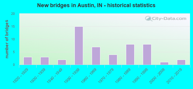
- New bridges - historical statistics
- 31920-1929
- 31930-1939
- 21940-1949
- 151950-1959
- 71960-1969
- 41970-1979
- 81980-1989
- 81990-1999
- 12000-2009
- 22010-2019

- Reconstructed bridges - Historical Statistics
- 41970-1979
- 121980-1989
- 41990-1999
- 52000-2009
- 32010-2019
- 12020-2022


- Bridge Condition - Deck
- 8.9%Very good
- 44.4%Good
- 28.9%Satisfactory
- 15.6%Fair
- 2.2%Poor

- Bridge Condition - Superstructure
- 8.9%Very good
- 37.8%Good
- 33.3%Satisfactory
- 15.6%Fair
- 4.4%Poor

- Bridge Condition - Substructure
- 4.4%Very good
- 48.9%Good
- 26.7%Satisfactory
- 17.8%Fair
- 2.2%Poor

- Bridge Condition - Channel
- 6.5%Very good
- 30.4%Good
- 45.7%Satisfactory
- 15.2%Fair
- 2.2%Poor

- Bridge Condition - Culverts
- 16.7%Very good
- 33.3%Good
- 50.0%Satisfactory
Find on map >> Show street view
Structure Number: 13, Location: 01.59 S SR 44 (Lat: 39.615631, Lng: -85.129589), Route carried "on" structure: State highway 1, Year Built: 1961, Year Reconstructed: 2001, Status: Open, Structure Length: 4.60m (15.09ft), Average Daily Traffic: 5,339 (year 2015), Truck Traffic: 18%, Average Future Daily Traffic: 12,000 (year 2030), Design Load: HS 20, Features Intersected: VILLAGE CREEK
Minimum Vertical Clearance: 30+ m (98+ ft), Kilometerpoint: 11.378, Lanes on structure: 2, Owner: State Highway Agency, Approaching Roadway Width: 9.1m (29.9ft), Skew: 2 degrees, Material/Design: Prestressed concrete continuous, Design/Construction: Stringer/Multi-beam, Number Of Spans In Main Unit: 3, Length of Maximum Span: 18.0m (59.1ft), Curb-To-Curb Width: 12.4m (40.7ft), Out-to-Out Width: 13.3m (43.6ft)
Condition: Deck: Good, Superstructure: Very good, Substructure: Good, Channel: Good, Operating Rating: 47.8 metric tons, Method Used To Determine Operating Rating: Load Factor (LF), Inventory Rating: 28.6 metric tons, Method Used To Determine Inventory Rating: Load Factor (LF), Structural Evaluation: Better than present minimum criteria, Deck Geometry: Somewhat better than minimum adequacy, Waterway Adequacy: Superior to present desirable criteria, Approach Roadway Alignment: Equal to present desirable criteria, Designated Inspection Frequency: Every 24 months, Inspection Date: May 2021, Deck Structure Type: Concrete Cast-file-Place, Wearing Surface/Protective System: Wearing Surface: Monolithic Concrete, Deck Protection: Epoxy Coated Reinforcing
Find on map >> Show street view
Structure Number: 64, Location: 02.80 W US 6 (Lat: 41.517111, Lng: -86.953239), Route carried "on" structure: State highway 2, Year Built: 1956, Year Reconstructed: 1993, Status: Open, Structure Length: 4.97m (16.31ft), Average Daily Traffic: 4,878 (year 2004), Truck Traffic: 10%, Average Future Daily Traffic: 8,097 (year 2030), Design Load: HS 20, Features Intersected: CSX RR
Minimum Vertical Clearance: 30+ m (98+ ft), Kilometerpoint: 40.668, Lanes on structure: 2, Owner: State Highway Agency, Approaching Roadway Width: 12.5m (41.0ft), Material/Design: Steel continuous, Design/Construction: Stringer/Multi-beam, Number Of Spans In Main Unit: 3, Length of Maximum Span: 18.3m (60.0ft), Curb-To-Curb Width: 11.0m (36.1ft), Out-to-Out Width: 11.9m (39.0ft)
Condition: Deck: Good, Superstructure: Satisfactory, Substructure: Satisfactory, Operating Rating: 51.2 metric tons, Method Used To Determine Operating Rating: Load and Resistance Factor Rating (LRFR) rating reported by rating factor(RF) method using HL-93 loadings, Inventory Rating: 39.5 metric tons, Method Used To Determine Inventory Rating: Load and Resistance Factor Rating (LRFR) rating reported by rating factor(RF) method using HL-93 loadings, Structural Evaluation: Equal to present minimum criteria, Deck Geometry: Somewhat better than minimum adequacy, Underclear: Better than present minimum criteria, Approach Roadway Alignment: Equal to present desirable criteria, Designated Inspection Frequency: Every 24 months, Inspection Date: December 2020, Deck Structure Type: Concrete Cast-file-Place, Wearing Surface/Protective System: Wearing Surface: Monolithic Concrete, Deck Protection: Epoxy Coated Reinforcing
Find on map >> Show street view
Structure Number: 131, Location: 04.19 S SR 205 (Lat: 41.237181, Lng: -85.167300), Route carried "on" structure: State highway 3, Year Built: 1959, Year Reconstructed: 1987, Status: Open, Structure Length: 2.35m (7.71ft), Average Daily Traffic: 7,424 (year 2019), Truck Traffic: 4%, Average Future Daily Traffic: 15,000 (year 2032), Design Load: HL 93, Features Intersected: WILLOW CREEK
Minimum Vertical Clearance: 30+ m (98+ ft), Kilometerpoint: 12.295, Lanes on structure: 2, Owner: State Highway Agency, Approaching Roadway Width: 11.3m (37.1ft), Material/Design: Concrete continuous, Design/Construction: Slab, Number Of Spans In Main Unit: 3, Length of Maximum Span: 8.8m (28.9ft), Curb-To-Curb Width: 12.2m (40.0ft), Out-to-Out Width: 13.1m (43.0ft)
Condition: Deck: Fair, Superstructure: Fair, Substructure: Good, Channel: Good, Operating Rating: 31.4 metric tons, Method Used To Determine Operating Rating: Load and Resistance Factor Rating (LRFR) rating reported by rating factor(RF) method using HL-93 loadings, Inventory Rating: 24.3 metric tons, Method Used To Determine Inventory Rating: Load and Resistance Factor Rating (LRFR) rating reported by rating factor(RF) method using HL-93 loadings, Structural Evaluation: Somewhat better than minimum adequacy, Deck Geometry: Better than present minimum criteria, Waterway Adequacy: Equal to present desirable criteria, Approach Roadway Alignment: Equal to present desirable criteria, Length Of Structure Improvement: 3.57m (11.71ft), Designated Inspection Frequency: Every 24 months, Inspection Date: July 2020, Bridge Improvement Cost: $82,000, Total Project Cost: $463,000, Deck Structure Type: Concrete Cast-file-Place, Wearing Surface/Protective System: Wearing Surface: Latex Concrete
Find on map >> Show street view
Structure Number: 186, Location: 00.39 E SR 427 (Lat: 41.433589, Lng: -85.012661), Route carried "on" structure: US 6, Year Built: 1926, Year Reconstructed: 1991, Status: Open, Structure Length: 1.85m (6.07ft), Average Daily Traffic: 6,098 (year 2020), Truck Traffic: 23%, Average Future Daily Traffic: 10,513 (year 2030), Design Load: HS 20, Features Intersected: CEDAR CREEK
Minimum Vertical Clearance: 30+ m (98+ ft), Kilometerpoint: 15.611, Lanes on structure: 2, Base Highway Network: Yes (, Subroute: 1), Owner: State Highway Agency, Approaching Roadway Width: 11.9m (39.0ft), Skew: 4 degrees, Material/Design: Concrete, Design/Construction: Stringer/Multi-beam, Number Of Spans In Main Unit: 2, Length of Maximum Span: 8.5m (27.9ft), Curb-To-Curb Width: 11.8m (38.7ft), Out-to-Out Width: 12.7m (41.7ft)
Condition: Deck: Fair, Superstructure: Fair, Substructure: Fair, Channel: Fair, Operating Rating: 38.6 metric tons, Method Used To Determine Operating Rating: Load and Resistance Factor Rating (LRFR) rating reported by rating factor(RF) method using HL-93 loadings, Inventory Rating: 29.5 metric tons, Method Used To Determine Inventory Rating: Load and Resistance Factor Rating (LRFR) rating reported by rating factor(RF) method using HL-93 loadings, Structural Evaluation: Somewhat better than minimum adequacy, Deck Geometry: Somewhat better than minimum adequacy, Waterway Adequacy: Equal to present desirable criteria, Approach Roadway Alignment: Equal to present desirable criteria, Designated Inspection Frequency: Every 24 months, Inspection Date: September 2020, Deck Structure Type: Concrete Cast-file-Place, Wearing Surface/Protective System: Wearing Surface: Latex Concrete
Find on map >> Show street view
Structure Number: 187, Location: 01.19 E SR 427 (Lat: 41.430900, Lng: -84.996931), Route carried "on" structure: US 6, Year Built: 1950, Year Reconstructed: 1991, Status: Open, Structure Length: 2.18m (7.15ft), Average Daily Traffic: 6,201 (year 2020), Truck Traffic: 22%, Average Future Daily Traffic: 10,023 (year 2030), Design Load: HS 20, Features Intersected: MATSON DITCH
Minimum Vertical Clearance: 30+ m (98+ ft), Kilometerpoint: 16.898, Lanes on structure: 2, Base Highway Network: Yes (, Subroute: 1), Owner: State Highway Agency, Approaching Roadway Width: 10.1m (33.1ft), Skew: 1 degrees, Material/Design: Concrete continuous, Design/Construction: Slab, Number Of Spans In Main Unit: 3, Length of Maximum Span: 8.5m (27.9ft), Curb-To-Curb Width: 10.2m (33.5ft), Out-to-Out Width: 11.1m (36.4ft)
Condition: Deck: Fair, Superstructure: Fair, Substructure: Satisfactory, Channel: Good, Operating Rating: 39.9 metric tons, Method Used To Determine Operating Rating: Load and Resistance Factor Rating (LRFR) rating reported by rating factor(RF) method using HL-93 loadings, Inventory Rating: 30.8 metric tons, Method Used To Determine Inventory Rating: Load and Resistance Factor Rating (LRFR) rating reported by rating factor(RF) method using HL-93 loadings, Structural Evaluation: Somewhat better than minimum adequacy, Deck Geometry: Meets minimum limits, Waterway Adequacy: Equal to present desirable criteria, Approach Roadway Alignment: Equal to present desirable criteria, Designated Inspection Frequency: Every 24 months, Inspection Date: September 2020, Deck Structure Type: Concrete Cast-file-Place, Wearing Surface/Protective System: Wearing Surface: Latex Concrete
Find on map >> Show street view
Structure Number: 3086, Location: 00.58 W US 41 (Lat: 41.694711, Lng: -87.515717), Route carried "on" structure: ServiceOther road , Year Built: 1996, Status: Open, Structure Length: 4.08m (13.39ft), Average Daily Traffic: 5,778 (year 2004), Truck Traffic: 2%, Average Future Daily Traffic: 8,142 (year 2030), Design Load: HS 20, Features Intersected: US 12/20/41 EB/WB, Facility Carried by Structure: HAMMOND MARINA DR
Minimum Vertical Clearance: 30+ m (98+ ft), Kilometerpoint: 0.000, Lanes on structure: 2, Lanes under structure: 6, Owner: County Highway Agency, Approaching Roadway Width: 11.0m (36.1ft), Material/Design: Prestressed concrete, Design/Construction: Tee Beam, Number Of Spans In Main Unit: 1, Length of Maximum Span: 39.5m (129.6ft), Curb or Sidewalk Widths: Left: 0.0m, Right: 1.7m (5.6ft), Curb-To-Curb Width: 11.0m (36.1ft), Out-to-Out Width: 13.7m (44.9ft)
Condition: Deck: Good, Superstructure: Satisfactory, Substructure: Very good, Operating Rating: 40.8 metric tons, Method Used To Determine Operating Rating: Allowable Stress (AS), Inventory Rating: 32.7 metric tons, Method Used To Determine Inventory Rating: Allowable Stress (AS), Structural Evaluation: Equal to present minimum criteria, Deck Geometry: Meets minimum limits, Underclear: Equal to present minimum criteria, Approach Roadway Alignment: Equal to present desirable criteria, Designated Inspection Frequency: Every 24 months, Inspection Date: September 2020, Deck Structure Type: Concrete Cast-file-Place, Wearing Surface/Protective System: Wearing Surface: Monolithic Concrete, Deck Protection: Epoxy Coated Reinforcing
Find on map >> Show street view
Structure Number: 3335, Location: 02.65 S SR 37 (Lat: 40.125769, Lng: -85.863511), Route carried "on" structure: State highway 13, Year Built: 1990, Status: Open, Structure Length: 0.66m (2.17ft), Average Daily Traffic: 1,550 (year 2004), Truck Traffic: 10%, Average Future Daily Traffic: 2,600 (year 2030), Design Load: HS 20, Features Intersected: DRAINAGE DITCH
Minimum Vertical Clearance: 30+ m (98+ ft), Kilometerpoint: 5.826, Lanes on structure: 2, Owner: State Highway Agency, Approaching Roadway Width: 8.5m (27.9ft), Material/Design: Concrete, Design/Construction: Culvert, Number Of Spans In Main Unit: 2, Length of Maximum Span: 3.0m (9.8ft)
Condition: Channel: Good, Culverts: Satisfactory, Operating Rating: 54.5 metric tons, Method Used To Determine Operating Rating: Field evaluation and documented engineering judgment, Inventory Rating: 32.7 metric tons, Method Used To Determine Inventory Rating: Field evaluation and documented engineering judgment, Structural Evaluation: Equal to present minimum criteria, Waterway Adequacy: Equal to present desirable criteria, Approach Roadway Alignment: Equal to present desirable criteria, Designated Inspection Frequency: Every 24 months, Inspection Date: December 2020
Find on map >> Show street view
Structure Number: 907, Location: 00.56 S SR 256 (Lat: 38.735681, Lng: -85.798531), Route carried "on" structure: US 31, Year Built: 1926, Year Reconstructed: 2013, Status: Open, Structure Length: 1.78m (5.84ft), Average Daily Traffic: 12,500 (year 2012), Truck Traffic: 6%, Average Future Daily Traffic: 13,120 (year 2032), Design Load: HS 20+Mod, Features Intersected: HUTTO CREEK
Minimum Vertical Clearance: 30+ m (98+ ft), Kilometerpoint: 15.369, Lanes on structure: 2, Owner: State Highway Agency, Approaching Roadway Width: 13.3m (43.6ft), Material/Design: Steel, Design/Construction: Stringer/Multi-beam, Number Of Spans In Main Unit: 1, Length of Maximum Span: 16.8m (55.1ft), Curb-To-Curb Width: 13.3m (43.6ft), Out-to-Out Width: 14.2m (46.6ft)
Condition: Deck: Very good, Superstructure: Good, Substructure: Satisfactory, Channel: Good, Operating Rating: 41.8 metric tons, Method Used To Determine Operating Rating: Load and Resistance Factor Rating (LRFR) rating reported by rating factor(RF) method using HL-93 loadings, Inventory Rating: 32.1 metric tons, Method Used To Determine Inventory Rating: Load and Resistance Factor Rating (LRFR) rating reported by rating factor(RF) method using HL-93 loadings, Structural Evaluation: Equal to present minimum criteria, Deck Geometry: Somewhat better than minimum adequacy, Waterway Adequacy: Equal to present minimum criteria, Approach Roadway Alignment: Equal to present desirable criteria, Designated Inspection Frequency: Every 24 months, Inspection Date: April 2022, Deck Structure Type: Concrete Cast-file-Place, Wearing Surface/Protective System: Wearing Surface: Monolithic Concrete, Deck Protection: Epoxy Coated Reinforcing
Find on map >> Show street view
Structure Number: 908, Location: 01.37 S I-65 (Lat: 38.762981, Lng: -85.817250), Route carried "on" structure: US 31, Year Built: 1980, Year Reconstructed: 2012, Status: Open, Structure Length: 6.49m (21.29ft), Average Daily Traffic: 5,470 (year 2012), Truck Traffic: 14%, Average Future Daily Traffic: 5,750 (year 2032), Design Load: HS 20, Features Intersected: MUSCATATUCK RIVER OVFL
Minimum Vertical Clearance: 30+ m (98+ ft), Kilometerpoint: 18.829, Lanes on structure: 2, Owner: State Highway Agency, Approaching Roadway Width: 13.3m (43.6ft), Skew: 2 degrees, Material/Design: Prestressed concrete continuous, Design/Construction: Stringer/Multi-beam, Number Of Spans In Main Unit: 3, Length of Maximum Span: 21.5m (70.5ft), Curb-To-Curb Width: 13.3m (43.6ft), Out-to-Out Width: 14.2m (46.6ft)
Condition: Deck: Good, Superstructure: Good, Substructure: Good, Channel: Very good, Operating Rating: 57.7 metric tons, Method Used To Determine Operating Rating: Load and Resistance Factor Rating (LRFR) rating reported by rating factor(RF) method using HL-93 loadings, Inventory Rating: 44.4 metric tons, Method Used To Determine Inventory Rating: Load and Resistance Factor Rating (LRFR) rating reported by rating factor(RF) method using HL-93 loadings, Structural Evaluation: Better than present minimum criteria, Deck Geometry: Somewhat better than minimum adequacy, Waterway Adequacy: Better than present minimum criteria, Approach Roadway Alignment: Equal to present desirable criteria, Designated Inspection Frequency: Every 24 months, Inspection Date: April 2022, Deck Structure Type: Concrete Cast-file-Place, Wearing Surface/Protective System: Wearing Surface: Monolithic Concrete, Deck Protection: Epoxy Coated Reinforcing
Find on map >> Show street view
Structure Number: 909, Location: 00.80 S I-65 (Lat: 38.770600, Lng: -85.822589), Route carried "on" structure: US 31, Year Built: 1980, Year Reconstructed: 2016, Status: Open, Structure Length: 20.17m (66.17ft), Average Daily Traffic: 4,560 (year 2014), Truck Traffic: 6%, Average Future Daily Traffic: 4,960 (year 2034), Design Load: HS 20, Features Intersected: MUSCATATUCK RIVER
Minimum Vertical Clearance: 30+ m (98+ ft), Kilometerpoint: 19.747, Lanes on structure: 2, Owner: State Highway Agency, Approaching Roadway Width: 13.5m (44.3ft), Skew: 2 degrees, Material/Design: Prestressed concrete continuous, Design/Construction: Stringer/Multi-beam, Number Of Spans In Main Unit: 8, Length of Maximum Span: 25.1m (82.3ft), Curb-To-Curb Width: 13.3m (43.6ft), Out-to-Out Width: 14.2m (46.6ft)
Condition: Deck: Very good, Superstructure: Good, Substructure: Satisfactory, Channel: Satisfactory, Operating Rating: 54.4 metric tons, Method Used To Determine Operating Rating: Load and Resistance Factor Rating (LRFR) rating reported by rating factor(RF) method using HL-93 loadings, Inventory Rating: 42.1 metric tons, Method Used To Determine Inventory Rating: Load and Resistance Factor Rating (LRFR) rating reported by rating factor(RF) method using HL-93 loadings, Structural Evaluation: Equal to present minimum criteria, Deck Geometry: Equal to present minimum criteria, Waterway Adequacy: Better than present minimum criteria, Approach Roadway Alignment: Equal to present desirable criteria, Designated Inspection Frequency: Every 24 months, Underwater Inspection Frequency: Every 60 months, Inspection Date: April 2022, Underwater Inspection Date: July 2018, Deck Structure Type: Concrete Cast-file-Place, Wearing Surface/Protective System: Wearing Surface: Latex Concrete, Deck Protection: Epoxy Coated Reinforcing
Find on map >> Show street view
Structure Number: 1293, Location: 07.65 E SR 103 (Lat: 39.917961, Lng: -85.222189), Route carried "on" structure: State highway 38, Year Built: 1964, Year Reconstructed: 2001, Status: Open, Structure Length: 2.03m (6.66ft), Average Daily Traffic: 3,450 (year 2004), Truck Traffic: 10%, Average Future Daily Traffic: 5,727 (year 2029), Design Load: HS 20, Features Intersected: SYMONDS CREEK
Minimum Vertical Clearance: 30+ m (98+ ft), Kilometerpoint: 31.704, Lanes on structure: 2, Owner: State Highway Agency, Approaching Roadway Width: 9.8m (32.2ft), Skew: 1 degrees, Material/Design: Concrete continuous, Design/Construction: Slab, Number Of Spans In Main Unit: 3, Length of Maximum Span: 7.9m (25.9ft), Curb-To-Curb Width: 12.6m (41.3ft), Out-to-Out Width: 13.6m (44.6ft)
Condition: Deck: Satisfactory, Superstructure: Satisfactory, Substructure: Good, Channel: Satisfactory, Operating Rating: 53.1 metric tons, Method Used To Determine Operating Rating: Load and Resistance Factor Rating (LRFR) rating reported by rating factor(RF) method using HL-93 loadings, Inventory Rating: 41.1 metric tons, Method Used To Determine Inventory Rating: Load and Resistance Factor Rating (LRFR) rating reported by rating factor(RF) method using HL-93 loadings, Structural Evaluation: Equal to present minimum criteria, Deck Geometry: Equal to present minimum criteria, Waterway Adequacy: Superior to present desirable criteria, Approach Roadway Alignment: Equal to present desirable criteria, Designated Inspection Frequency: Every 24 months, Inspection Date: August 2020, Deck Structure Type: Concrete Cast-file-Place, Wearing Surface/Protective System: Wearing Surface: Latex Concrete
Find on map >> Show street view
Structure Number: 1298, Location: 02.59 E SR 1 (Lat: 39.902369, Lng: -85.098350), Route carried "on" structure: State highway 38, Year Built: 1957, Year Reconstructed: 1982, Status: Open, Structure Length: 4.97m (16.31ft), Average Daily Traffic: 7,301 (year 2004), Truck Traffic: 10%, Average Future Daily Traffic: 12,120 (year 2029), Design Load: HS 20, Features Intersected: MARTINDALE CREEK
Minimum Vertical Clearance: 30+ m (98+ ft), Kilometerpoint: 9.238, Lanes on structure: 2, Owner: State Highway Agency, Approaching Roadway Width: 9.1m (29.9ft), Skew: 2 degrees, Material/Design: Steel continuous, Design/Construction: Stringer/Multi-beam, Number Of Spans In Main Unit: 3, Length of Maximum Span: 18.3m (60.0ft), Curb-To-Curb Width: 10.4m (34.1ft), Out-to-Out Width: 11.1m (36.4ft)
Condition: Deck: Satisfactory, Superstructure: Good, Substructure: Good, Channel: Satisfactory, Operating Rating: 61.0 metric tons, Method Used To Determine Operating Rating: Load Factor (LF), Inventory Rating: 36.5 metric tons, Method Used To Determine Inventory Rating: Load Factor (LF), Structural Evaluation: Better than present minimum criteria, Deck Geometry: Meets minimum limits, Waterway Adequacy: Superior to present desirable criteria, Approach Roadway Alignment: Equal to present desirable criteria, Designated Inspection Frequency: Every 24 months, Inspection Date: August 2020, Deck Structure Type: Concrete Cast-file-Place, Wearing Surface/Protective System: Wearing Surface: Monolithic Concrete, Deck Protection: Epoxy Coated Reinforcing
Find on map >> Show street view
Structure Number: 1302, Location: 01.43 W US 35 (Lat: 39.881869, Lng: -84.968839), Route carried "on" structure: State highway 38, Year Built: 1957, Year Reconstructed: 2017, Status: Open, Structure Length: 6.49m (21.29ft), Average Daily Traffic: 2,760 (year 2017), Truck Traffic: 15%, Average Future Daily Traffic: 2,760 (year 2037), Design Load: HS 20, Features Intersected: NOLANDS BRANCH
Minimum Vertical Clearance: 30+ m (98+ ft), Kilometerpoint: 20.632, Lanes on structure: 2, Owner: State Highway Agency, Approaching Roadway Width: 9.8m (32.2ft), Skew: 3 degrees, Material/Design: Steel continuous, Design/Construction: Stringer/Multi-beam, Number Of Spans In Main Unit: 3, Length of Maximum Span: 23.8m (78.1ft), Curb-To-Curb Width: 10.4m (34.1ft), Out-to-Out Width: 11.1m (36.4ft)
Condition: Deck: Fair, Superstructure: Good, Substructure: Good, Channel: Satisfactory, Operating Rating: 35.1 metric tons, Method Used To Determine Operating Rating: Load and Resistance Factor (LRFR), Inventory Rating: 35.1 metric tons, Method Used To Determine Inventory Rating: Load and Resistance Factor (LRFR), Structural Evaluation: Better than present minimum criteria, Deck Geometry: Somewhat better than minimum adequacy, Waterway Adequacy: Superior to present desirable criteria, Approach Roadway Alignment: Equal to present desirable criteria, Designated Inspection Frequency: Every 24 months, Inspection Date: August 2020, Deck Structure Type: Concrete Cast-file-Place, Wearing Surface/Protective System: Wearing Surface: Latex Concrete
Find on map >> Show street view
Structure Number: 1308, Location: 03.73 N SR 256 (Lat: 38.796781, Lng: -85.953467), Route carried "on" structure: State highway 39, Year Built: 1970, Year Reconstructed: 1980, Status: Open, Structure Length: 2.68m (8.79ft), Average Daily Traffic: 1,043 (year 2004), Truck Traffic: 10%, Average Future Daily Traffic: 1,829 (year 2031), Design Load: HS 20, Features Intersected: GRASSY FORK
Minimum Vertical Clearance: 30+ m (98+ ft), Kilometerpoint: 4.989, Lanes on structure: 2, Owner: State Highway Agency, Approaching Roadway Width: 7.9m (25.9ft), Material/Design: Prestressed concrete, Design/Construction: Box Beam or Girders - Multiple, Number Of Spans In Main Unit: 3, Length of Maximum Span: 12.2m (40.0ft), Curb-To-Curb Width: 8.7m (28.5ft), Out-to-Out Width: 9.4m (30.8ft)
Condition: Deck: Good, Superstructure: Satisfactory, Substructure: Satisfactory, Channel: Satisfactory, Operating Rating: 39.2 metric tons, Method Used To Determine Operating Rating: Load and Resistance Factor Rating (LRFR) rating reported by rating factor(RF) method using HL-93 loadings, Inventory Rating: 30.5 metric tons, Method Used To Determine Inventory Rating: Load and Resistance Factor Rating (LRFR) rating reported by rating factor(RF) method using HL-93 loadings, Structural Evaluation: Equal to present minimum criteria, Deck Geometry: Somewhat better than minimum adequacy, Waterway Adequacy: Equal to present desirable criteria, Approach Roadway Alignment: Equal to present minimum criteria, Designated Inspection Frequency: Every 24 months, Inspection Date: October 2021, Deck Structure Type: Concrete Cast-file-Place, Wearing Surface/Protective System: Wearing Surface: Latex Concrete, Deck Protection: Epoxy Coated Reinforcing
Find on map >> Show street view
Structure Number: 1309, Location: 03.89 S SR 250 (Lat: 38.812139, Lng: -85.977739), Route carried "on" structure: State highway 39, Year Built: 1970, Year Reconstructed: 1998, Status: Open, Structure Length: 1.89m (6.20ft), Average Daily Traffic: 731 (year 2004), Truck Traffic: 10%, Average Future Daily Traffic: 1,281 (year 2031), Design Load: HS 20, Features Intersected: POND CREEK
Minimum Vertical Clearance: 30+ m (98+ ft), Kilometerpoint: 7.757, Lanes on structure: 2, Owner: State Highway Agency, Approaching Roadway Width: 9.1m (29.9ft), Skew: 2 degrees, Material/Design: Concrete continuous, Design/Construction: Slab, Number Of Spans In Main Unit: 3, Length of Maximum Span: 7.3m (24.0ft), Curb-To-Curb Width: 8.4m (27.6ft), Out-to-Out Width: 9.3m (30.5ft)
Condition: Deck: Poor, Superstructure: Poor, Substructure: Poor, Channel: Satisfactory, Operating Rating: 36.0 metric tons, Method Used To Determine Operating Rating: Load and Resistance Factor Rating (LRFR) rating reported by rating factor(RF) method using HL-93 loadings, Inventory Rating: 27.5 metric tons, Method Used To Determine Inventory Rating: Load and Resistance Factor Rating (LRFR) rating reported by rating factor(RF) method using HL-93 loadings, Structural Evaluation: Meets minimum limits, Deck Geometry: Somewhat better than minimum adequacy, Waterway Adequacy: Better than present minimum criteria, Approach Roadway Alignment: Equal to present minimum criteria, Designated Inspection Frequency: Every 12 months, Inspection Date: October 2021, Deck Structure Type: Concrete Cast-file-Place, Wearing Surface/Protective System: Wearing Surface: Latex Concrete
Find on map >> Show street view
Structure Number: 1456, Location: 00.90 N of SR 56 (Lat: 38.491000, Lng: -87.564061), Route carried "on" structure: US 41, Year Built: 1958, Year Reconstructed: 2020, Status: Open, Structure Length: 73.27m (240.39ft), Average Daily Traffic: 12,500 (year 2019), Truck Traffic: 26%, Average Future Daily Traffic: 18,215 (year 2039), Design Load: HS 20, Features Intersected: WHITE RIVER
Minimum Vertical Clearance: 30+ m (98+ ft), Kilometerpoint: 38.077, Lanes on structure: 4, Base Highway Network: Yes (, Subroute: 1), Owner: State Highway Agency, Approaching Roadway Width: 21.3m (69.9ft), Skew: 30 degrees, Material/Design: Steel continuous, Design/Construction: Girder and Floorbeam System, Number Of Spans In Main Unit: 16, Length of Maximum Span: 47.5m (155.8ft), Curb-To-Curb Width: 18.9m (62.0ft), Out-to-Out Width: 19.8m (65.0ft)
Condition: Deck: Good, Superstructure: Good, Substructure: Good, Channel: Satisfactory, Operating Rating: 49.3 metric tons, Method Used To Determine Operating Rating: Load Factor (LF), Inventory Rating: 29.5 metric tons, Method Used To Determine Inventory Rating: Load Factor (LF), Structural Evaluation: Better than present minimum criteria, Deck Geometry: Equal to present minimum criteria, Waterway Adequacy: Superior to present desirable criteria, Approach Roadway Alignment: Equal to present desirable criteria, Length Of Structure Improvement: 73.27m (240.39ft), Designated Inspection Frequency: Every 24 months, Critical Feature Inspection Frequency: Every 24 months, Underwater Inspection Frequency: Every 60 months, Other Special Inspection Frequency: Every 60 months, Inspection Date: June 2021, Critical Feature Inspection Date: June 2021, Underwater Inspection Date: September 2018, Other Special Inspection Date: November 2018, Bridge Improvement Cost: $7,707,000, Total Project Cost: $7,707,000 ( Estimate for 2015), Deck Structure Type: Concrete Cast-file-Place, Wearing Surface/Protective System: Wearing Surface: Latex Concrete
Find on map >> Show street view
Structure Number: 1703, Location: 03.45 E SR 59 (Lat: 39.386050, Lng: -87.046431), Route carried "on" structure: State highway 46, Year Built: 1933, Year Reconstructed: 1984, Status: Open, Structure Length: 1.52m (4.99ft), Average Daily Traffic: 3,350 (year 2020), Truck Traffic: 13%, Average Future Daily Traffic: 3,410 (year 2030), Design Load: HS 20, Features Intersected: HOG CREEK
Minimum Vertical Clearance: 30+ m (98+ ft), Kilometerpoint: 16.673, Lanes on structure: 2, Owner: State Highway Agency, Approaching Roadway Width: 13.4m (44.0ft), Skew: 3 degrees, Material/Design: Steel, Design/Construction: Stringer/Multi-beam, Number Of Spans In Main Unit: 1, Length of Maximum Span: 14.1m (46.3ft), Curb-To-Curb Width: 13.4m (44.0ft), Out-to-Out Width: 14.2m (46.6ft)
Condition: Deck: Good, Superstructure: Satisfactory, Substructure: Fair, Channel: Satisfactory, Operating Rating: 62.8 metric tons, Method Used To Determine Operating Rating: Load Factor (LF), Inventory Rating: 37.6 metric tons, Method Used To Determine Inventory Rating: Load Factor (LF), Structural Evaluation: Somewhat better than minimum adequacy, Deck Geometry: Better than present minimum criteria, Waterway Adequacy: Superior to present desirable criteria, Approach Roadway Alignment: Equal to present desirable criteria, Designated Inspection Frequency: Every 24 months, Inspection Date: Febuary 2022, Deck Structure Type: Concrete Cast-file-Place, Wearing Surface/Protective System: Wearing Surface: Epoxy Overlay, Deck Protection: Epoxy Coated Reinforcing
Find on map >> Show street view
Structure Number: 1858, Location: 00.42 W SR 135 (Lat: 38.879781, Lng: -86.064750), Route carried "on" structure: US 50, Year Built: 1934, Year Reconstructed: 2016, Status: Open, Structure Length: 7.04m (23.10ft), Average Daily Traffic: 6,667 (year 2015), Truck Traffic: 12%, Average Future Daily Traffic: 9,114 (year 2036), Design Load: HS 20, Features Intersected: CSX RR
Minimum Vertical Clearance: 30+ m (98+ ft), Kilometerpoint: 19.505, Lanes on structure: 2, Base Highway Network: Yes (, Subroute: 1), Owner: State Highway Agency, Approaching Roadway Width: 13.4m (44.0ft), Skew: 4 degrees, Material/Design: Prestressed concrete, Design/Construction: Stringer/Multi-beam, Number Of Spans In Main Unit: 5, Length of Maximum Span: 14.8m (48.6ft), Curb-To-Curb Width: 13.4m (44.0ft), Out-to-Out Width: 14.4m (47.2ft)
Condition: Deck: Good, Superstructure: Good, Substructure: Good, Operating Rating: 60.6 metric tons, Method Used To Determine Operating Rating: Load and Resistance Factor Rating (LRFR) rating reported by rating factor(RF) method using HL-93 loadings, Inventory Rating: 39.5 metric tons, Method Used To Determine Inventory Rating: Load and Resistance Factor Rating (LRFR) rating reported by rating factor(RF) method using HL-93 loadings, Structural Evaluation: Better than present minimum criteria, Deck Geometry: Equal to present minimum criteria, Underclear: Meets minimum limits, Approach Roadway Alignment: Equal to present minimum criteria, Designated Inspection Frequency: Every 24 months, Inspection Date: July 2021, Deck Structure Type: Concrete Precast Panels, Wearing Surface/Protective System: Wearing Surface: Epoxy Overlay, Deck Protection: Epoxy Coated Reinforcing
Find on map >> Show street view
Structure Number: 1859, Location: 04.47 W SR 11 (Lat: 38.924531, Lng: -85.961839), Route carried "on" structure: US 50, Year Built: 1999, Status: Open, Structure Length: 2.38m (7.81ft), Average Daily Traffic: 10,143 (year 2004), Truck Traffic: 8%, Average Future Daily Traffic: 14,194 (year 2033), Design Load: HS 20, Features Intersected: DEER CREEK
Minimum Vertical Clearance: 30+ m (98+ ft), Kilometerpoint: 30.578, Lanes on structure: 2, Base Highway Network: Yes (, Subroute: 1), Owner: State Highway Agency, Approaching Roadway Width: 13.7m (44.9ft), Skew: 3 degrees, Material/Design: Concrete continuous, Design/Construction: Slab, Number Of Spans In Main Unit: 3, Length of Maximum Span: 9.1m (29.9ft), Curb-To-Curb Width: 13.8m (45.3ft), Out-to-Out Width: 14.7m (48.2ft)
Condition: Deck: Satisfactory, Superstructure: Satisfactory, Substructure: Good, Channel: Good, Operating Rating: 39.5 metric tons, Method Used To Determine Operating Rating: Load and Resistance Factor Rating (LRFR) rating reported by rating factor(RF) method using HL-93 loadings, Inventory Rating: 30.5 metric tons, Method Used To Determine Inventory Rating: Load and Resistance Factor Rating (LRFR) rating reported by rating factor(RF) method using HL-93 loadings, Structural Evaluation: Equal to present minimum criteria, Deck Geometry: Superior to present desirable criteria, Waterway Adequacy: Equal to present desirable criteria, Approach Roadway Alignment: Equal to present desirable criteria, Designated Inspection Frequency: Every 24 months, Inspection Date: July 2021, Deck Structure Type: Concrete Cast-file-Place, Wearing Surface/Protective System: Wearing Surface: Monolithic Concrete, Deck Protection: Epoxy Coated Reinforcing
Find on map >> Show street view
Structure Number: 1861, Location: 00.82 W SR 11 (Lat: 38.952311, Lng: -85.904831), Route carried "on" structure: US 50, Year Built: 1986, Year Reconstructed: 2000, Status: Open, Structure Length: 2.62m (8.60ft), Average Daily Traffic: 22,132 (year 2004), Truck Traffic: 9%, Average Future Daily Traffic: 31,812 (year 2030), Design Load: HS 20, Features Intersected: VON FANGE DITCH
Minimum Vertical Clearance: 30+ m (98+ ft), Kilometerpoint: 36.452, Lanes on structure: 2, Base Highway Network: Yes (, Subroute: 1), Owner: State Highway Agency, Approaching Roadway Width: 16.5m (54.1ft), Skew: 4 degrees, Material/Design: Concrete continuous, Design/Construction: Slab, Number Of Spans In Main Unit: 3, Length of Maximum Span: 9.6m (31.5ft), Curb-To-Curb Width: 15.3m (50.2ft), Out-to-Out Width: 16.2m (53.1ft)
Condition: Deck: Satisfactory, Superstructure: Satisfactory, Substructure: Satisfactory, Channel: Good, Operating Rating: 46.0 metric tons, Method Used To Determine Operating Rating: Load and Resistance Factor Rating (LRFR) rating reported by rating factor(RF) method using HL-93 loadings, Inventory Rating: 35.6 metric tons, Method Used To Determine Inventory Rating: Load and Resistance Factor Rating (LRFR) rating reported by rating factor(RF) method using HL-93 loadings, Structural Evaluation: Equal to present minimum criteria, Deck Geometry: Superior to present desirable criteria, Waterway Adequacy: Equal to present desirable criteria, Approach Roadway Alignment: Equal to present desirable criteria, Designated Inspection Frequency: Every 24 months, Inspection Date: July 2021, Deck Structure Type: Concrete Cast-file-Place, Wearing Surface/Protective System: Wearing Surface: Latex Concrete, Deck Protection: Epoxy Coated Reinforcing
Find on map >> Show street view
Structure Number: 1862, Location: 00.46 W I-65 (Lat: 38.957939, Lng: -85.851919), Route carried "on" structure: US 50, Year Built: 1964, Year Reconstructed: 2021, Status: Open, Structure Length: 2.33m (7.64ft), Average Daily Traffic: 11,825 (year 2019), Truck Traffic: 5%, Average Future Daily Traffic: 12,642 (year 2039), Design Load: HS 20, Features Intersected: SANDY BRANCH
Minimum Vertical Clearance: 30+ m (98+ ft), Kilometerpoint: 41.167, Lanes on structure: 3, Base Highway Network: Yes (, Subroute: 1), Owner: State Highway Agency, Approaching Roadway Width: 15.2m (49.9ft), Skew: 1 degrees, Material/Design: Concrete continuous, Design/Construction: Slab, Number Of Spans In Main Unit: 3, Length of Maximum Span: 9.1m (29.9ft), Curb-To-Curb Width: 15.3m (50.2ft), Out-to-Out Width: 15.8m (51.8ft)
Condition: Deck: Good, Superstructure: Good, Substructure: Good, Channel: Very good, Operating Rating: 49.6 metric tons, Method Used To Determine Operating Rating: Load and Resistance Factor Rating (LRFR) rating reported by rating factor(RF) method using HL-93 loadings, Inventory Rating: 38.2 metric tons, Method Used To Determine Inventory Rating: Load and Resistance Factor Rating (LRFR) rating reported by rating factor(RF) method using HL-93 loadings, Structural Evaluation: Better than present minimum criteria, Deck Geometry: Equal to present minimum criteria, Waterway Adequacy: Better than present minimum criteria, Approach Roadway Alignment: Equal to present desirable criteria, Designated Inspection Frequency: Every 24 months, Inspection Date: July 2021, Deck Structure Type: Concrete Cast-file-Place, Wearing Surface/Protective System: Wearing Surface: Latex Concrete
Find on map >> Show street view
Structure Number: 1863, Location: 00.46 W I-65 (Lat: 38.958111, Lng: -85.851883), Route carried "on" structure: US 50, Year Built: 1964, Year Reconstructed: 2021, Status: Open, Structure Length: 2.33m (7.64ft), Average Daily Traffic: 16,705 (year 2019), Truck Traffic: 5%, Average Future Daily Traffic: 17,858 (year 2039), Design Load: HS 20, Features Intersected: SANDY BRANCH
Minimum Vertical Clearance: 30+ m (98+ ft), Kilometerpoint: 41.167, Lanes on structure: 2, Base Highway Network: Yes (, Subroute: 1), Owner: State Highway Agency, Approaching Roadway Width: 10.7m (35.1ft), Skew: 1 degrees, Material/Design: Concrete continuous, Design/Construction: Slab, Number Of Spans In Main Unit: 3, Length of Maximum Span: 9.1m (29.9ft), Curb or Sidewalk Widths: Left: 4.8m (15.7ft), Right: 0.0m, Curb-To-Curb Width: 10.6m (34.8ft), Out-to-Out Width: 15.8m (51.8ft)
Condition: Deck: Satisfactory, Superstructure: Satisfactory, Substructure: Good, Channel: Good, Operating Rating: 51.5 metric tons, Method Used To Determine Operating Rating: Load and Resistance Factor Rating (LRFR) rating reported by rating factor(RF) method using HL-93 loadings, Inventory Rating: 39.9 metric tons, Method Used To Determine Inventory Rating: Load and Resistance Factor Rating (LRFR) rating reported by rating factor(RF) method using HL-93 loadings, Structural Evaluation: Equal to present minimum criteria, Deck Geometry: Somewhat better than minimum adequacy, Waterway Adequacy: Better than present minimum criteria, Approach Roadway Alignment: Equal to present desirable criteria, Designated Inspection Frequency: Every 24 months, Inspection Date: July 2021, Deck Structure Type: Concrete Cast-file-Place, Wearing Surface/Protective System: Wearing Surface: Latex Concrete
Find on map >> Show street view
Structure Number: 1868, Location: 01.24 E OF SR 3 (Lat: 39.008150, Lng: -85.604850), Route carried "on" structure: County highway , Year Built: 1930, Year Reconstructed: 1996, Status: Open, Structure Length: 11.86m (38.91ft), Average Daily Traffic: 7,500 (year 2019), Truck Traffic: 5%, Average Future Daily Traffic: 11,575 (year 2039), Design Load: H 20, Features Intersected: VERNON FORK MUSCATATUCK, Facility Carried by Structure: OLD US 50
Minimum Vertical Clearance: 30+ m (98+ ft), Kilometerpoint: 18.234, Lanes on structure: 2, Owner: County Highway Agency, Approaching Roadway Width: 14.6m (47.9ft), Material/Design: Concrete, Design/Construction: Arch - Deck, Number Of Spans In Main Unit: 3, Length of Maximum Span: 57.9m (190.0ft), Curb-To-Curb Width: 13.4m (44.0ft), Out-to-Out Width: 14.3m (46.9ft)
Condition: Deck: Fair, Superstructure: Fair, Substructure: Satisfactory, Channel: Good, Operating Rating: 40.8 metric tons, Method Used To Determine Operating Rating: Field evaluation and documented engineering judgment, Inventory Rating: 32.7 metric tons, Method Used To Determine Inventory Rating: Field evaluation and documented engineering judgment, Structural Evaluation: Somewhat better than minimum adequacy, Deck Geometry: Equal to present minimum criteria, Waterway Adequacy: Better than present minimum criteria, Approach Roadway Alignment: Equal to present desirable criteria, Designated Inspection Frequency: Every 24 months, Other Special Inspection Frequency: Every 24 months, Inspection Date: April 2021, Other Special Inspection Date: April 2021, Deck Structure Type: Concrete Precast Panels, Wearing Surface/Protective System: Wearing Surface: Epoxy Overlay
Find on map >> Show street view
Structure Number: 1869, Location: 09.06 W US 421 (Lat: 39.065661, Lng: -85.435839), Route carried "on" structure: US 50, Year Built: 1986, Status: Open, Structure Length: 10.42m (34.19ft), Average Daily Traffic: 4,042 (year 2004), Truck Traffic: 10%, Average Future Daily Traffic: 5,656 (year 2033), Design Load: HS 20, Features Intersected: OTTER CREEK
Minimum Vertical Clearance: 30+ m (98+ ft), Kilometerpoint: 0.644, Lanes on structure: 2, Base Highway Network: Yes (, Subroute: 1), Owner: State Highway Agency, Approaching Roadway Width: 13.4m (44.0ft), Skew: 4 degrees, Material/Design: Steel continuous, Design/Construction: Stringer/Multi-beam, Number Of Spans In Main Unit: 3, Length of Maximum Span: 39.6m (129.9ft), Curb-To-Curb Width: 13.5m (44.3ft), Out-to-Out Width: 14.2m (46.6ft)
Condition: Deck: Satisfactory, Superstructure: Satisfactory, Substructure: Good, Channel: Good, Operating Rating: 23.7 metric tons, Method Used To Determine Operating Rating: Load and Resistance Factor Rating (LRFR) rating reported by rating factor(RF) method using HL-93 loadings, Inventory Rating: 18.1 metric tons, Method Used To Determine Inventory Rating: Load and Resistance Factor Rating (LRFR) rating reported by rating factor(RF) method using HL-93 loadings, Structural Evaluation: Somewhat better than minimum adequacy, Deck Geometry: Superior to present desirable criteria, Waterway Adequacy: Superior to present desirable criteria, Approach Roadway Alignment: Equal to present desirable criteria, Designated Inspection Frequency: Every 24 months, Inspection Date: August 2021, Deck Structure Type: Concrete Cast-file-Place, Wearing Surface/Protective System: Wearing Surface: Monolithic Concrete, Deck Protection: Epoxy Coated Reinforcing
Find on map >> Show street view
Structure Number: 3084, Location: 01.40 W I-65 (Lat: 38.742761, Lng: -85.843489), Route carried "on" structure: State highway 256, Year Built: 1941, Year Reconstructed: 1984, Status: Open, Structure Length: 8.69m (28.51ft), Average Daily Traffic: 1,547 (year 2004), Truck Traffic: 10%, Average Future Daily Traffic: 2,708 (year 2030), Design Load: H 20, Features Intersected: MUSCATATUCK RIVER
Minimum Vertical Clearance: 4.50m (14.76ft), Kilometerpoint: 4.941, Lanes on structure: 2, Owner: State Highway Agency, Approaching Roadway Width: 11.0m (36.1ft), Material/Design: Steel, Design/Construction: Truss - Thru, Number Of Spans In Main Unit: 1, Number Of Approach Spans: 2, Length of Maximum Span: 53.3m (174.9ft), Curb or Sidewalk Widths: Left: 0.1m (0.3ft), Right: 0.1m (0.3ft), Curb-To-Curb Width: 7.3m (24.0ft), Out-to-Out Width: 7.6m (24.9ft)
Condition: Deck: Fair, Superstructure: Fair, Substructure: Good, Channel: Fair, Operating Rating: 51.7 metric tons, Method Used To Determine Operating Rating: Load Factor (LF), Inventory Rating: 30.8 metric tons, Method Used To Determine Inventory Rating: Load Factor (LF), Structural Evaluation: Somewhat better than minimum adequacy, Deck Geometry: Meets minimum limits, Waterway Adequacy: Equal to present minimum criteria, Approach Roadway Alignment: Equal to present desirable criteria, Designated Inspection Frequency: Every 24 months, Critical Feature Inspection Frequency: Every 24 months, Inspection Date: November 2021, Critical Feature Inspection Date: November 2021, Deck Structure Type: Concrete Cast-file-Place, Wearing Surface/Protective System: Wearing Surface: Monolithic Concrete, Deck Protection: Epoxy Coated Reinforcing
Find on map >> Show street view
Structure Number: 3085, Location: 00.97 W I-65 (Lat: 38.742869, Lng: -85.835464), Route carried "on" structure: State highway 256, Year Built: 1940, Year Reconstructed: 1984, Status: Open, Structure Length: 4.39m (14.40ft), Average Daily Traffic: 1,402 (year 2004), Truck Traffic: 10%, Average Future Daily Traffic: 2,343 (year 2030), Design Load: H 20, Features Intersected: BEAVER POND CREEK
Minimum Vertical Clearance: 30+ m (98+ ft), Kilometerpoint: 0.692, Lanes on structure: 2, Owner: State Highway Agency, Approaching Roadway Width: 13.4m (44.0ft), Material/Design: Steel continuous, Design/Construction: Stringer/Multi-beam, Number Of Spans In Main Unit: 3, Length of Maximum Span: 16.8m (55.1ft), Curb-To-Curb Width: 12.9m (42.3ft), Out-to-Out Width: 13.7m (44.9ft)
Condition: Deck: Good, Superstructure: Satisfactory, Substructure: Fair, Channel: Satisfactory, Operating Rating: 45.3 metric tons, Method Used To Determine Operating Rating: Load Factor (LF), Inventory Rating: 27.1 metric tons, Method Used To Determine Inventory Rating: Load Factor (LF), Structural Evaluation: Somewhat better than minimum adequacy, Deck Geometry: Better than present minimum criteria, Waterway Adequacy: Better than present minimum criteria, Approach Roadway Alignment: Equal to present desirable criteria, Designated Inspection Frequency: Every 24 months, Inspection Date: October 2021, Deck Structure Type: Concrete Cast-file-Place, Wearing Surface/Protective System: Wearing Surface: Monolithic Concrete, Deck Protection: Epoxy Coated Reinforcing
Find on map >> Show street view
Structure Number: 3086, Location: 00.77 W US 31 (Lat: 38.740750, Lng: -85.818550), Route carried "on" structure: State highway 256, Year Built: 1959, Year Reconstructed: 2006, Status: Open, Structure Length: 6.71m (22.01ft), Average Daily Traffic: 8,335 (year 2004), Truck Traffic: 10%, Average Future Daily Traffic: 13,961 (year 2031), Design Load: HS 20+Mod, Features Intersected: I-65
Minimum Vertical Clearance: 30+ m (98+ ft), Kilometerpoint: 2.253, Lanes on structure: 4, Lanes under structure: 5, Owner: State Highway Agency, Approaching Roadway Width: 20.7m (67.9ft), Skew: 21 degrees, Material/Design: Steel continuous, Design/Construction: Stringer/Multi-beam, Number Of Spans In Main Unit: 4, Length of Maximum Span: 22.0m (72.2ft), Curb-To-Curb Width: 20.7m (67.9ft), Out-to-Out Width: 22.9m (75.1ft)
Condition: Deck: Good, Superstructure: Very good, Substructure: Good, Operating Rating: 45.7 metric tons, Method Used To Determine Operating Rating: Load and Resistance Factor Rating (LRFR) rating reported by rating factor(RF) method using HL-93 loadings, Inventory Rating: 35.3 metric tons, Method Used To Determine Inventory Rating: Load and Resistance Factor Rating (LRFR) rating reported by rating factor(RF) method using HL-93 loadings, Structural Evaluation: Better than present minimum criteria, Deck Geometry: Superior to present desirable criteria, Underclear: High priority of corrective action, Approach Roadway Alignment: Equal to present desirable criteria, Designated Inspection Frequency: Every 24 months, Inspection Date: October 2021, Deck Structure Type: Concrete Cast-file-Place, Wearing Surface/Protective System: Wearing Surface: Monolithic Concrete, Deck Protection: Epoxy Coated Reinforcing
Find on map >> Show street view
Structure Number: 32854, Location: 07.76 E US 27 (Lat: 41.063231, Lng: -84.989481), Route carried "on" structure: Interstate 469, Year Built: 1990, Status: Open, Structure Length: 7.53m (24.70ft), Average Daily Traffic: 16,694 (year 2020), Truck Traffic: 29%, Average Future Daily Traffic: 11,539 (year 2031), Design Load: HS 20, Features Intersected: US 30/SR 930
Minimum Vertical Clearance: 30+ m (98+ ft), Kilometerpoint: 31.286, Lanes on structure: 2, Lanes under structure: 5, Base Highway Network: Yes (, Subroute: 1), Owner: State Highway Agency, Approaching Roadway Width: 18.6m (61.0ft), Skew: 1 degrees, Material/Design: Steel continuous, Design/Construction: Stringer/Multi-beam, Number Of Spans In Main Unit: 2, Length of Maximum Span: 36.7m (120.4ft), Curb-To-Curb Width: 13.9m (45.6ft), Out-to-Out Width: 14.8m (48.6ft)
Condition: Deck: Very good, Superstructure: Very good, Substructure: Good, Operating Rating: 86.2 metric tons, Method Used To Determine Operating Rating: Load Factor (LF), Inventory Rating: 51.6 metric tons, Method Used To Determine Inventory Rating: Load Factor (LF), Structural Evaluation: Better than present minimum criteria, Deck Geometry: Superior to present desirable criteria, Underclear: Somewhat better than minimum adequacy, Approach Roadway Alignment: Equal to present desirable criteria, Designated Inspection Frequency: Every 24 months, Inspection Date: March 2021, Deck Structure Type: Concrete Cast-file-Place, Wearing Surface/Protective System: Wearing Surface: Epoxy Overlay, Deck Protection: Epoxy Coated Reinforcing
Find on map >> Show street view
Structure Number: 3413, Location: 01.59 E SR 66 (Lat: 38.250900, Lng: -86.333119), Route carried "on" structure: Interstate 64, Year Built: 1972, Status: Open, Structure Length: 0.67m (2.20ft), Average Daily Traffic: 18,371 (year 2004), Truck Traffic: 10%, Average Future Daily Traffic: 36,352 (year 2031), Design Load: HS 20+Mod, Features Intersected: JORDAN CREEK
Minimum Vertical Clearance: 30+ m (98+ ft), Kilometerpoint: 150.152, Lanes on structure: 4, Base Highway Network: Yes (, Subroute: 1), Owner: State Highway Agency, Approaching Roadway Width: 12.8m (42.0ft), Skew: 13 degrees, Material/Design: Concrete, Design/Construction: Culvert, Number Of Spans In Main Unit: 2, Length of Maximum Span: 3.0m (9.8ft), Curb-To-Curb Width: 23.2m (76.1ft), Out-to-Out Width: 39.6m (129.9ft)
Condition: Channel: Satisfactory, Culverts: Satisfactory, Operating Rating: 54.5 metric tons, Method Used To Determine Operating Rating: Field evaluation and documented engineering judgment, Inventory Rating: 32.7 metric tons, Method Used To Determine Inventory Rating: Field evaluation and documented engineering judgment, Structural Evaluation: Equal to present minimum criteria, Deck Geometry: Superior to present desirable criteria, Waterway Adequacy: Better than present minimum criteria, Approach Roadway Alignment: Equal to present desirable criteria, Designated Inspection Frequency: Every 24 months, Inspection Date: October 2021
Find on map >> Show street view
Structure Number: 3428, Location: 02.43 E SR 135 (Lat: 38.246850, Lng: -86.083750), Route carried "on" structure: Interstate 64, Year Built: 1974, Year Reconstructed: 1994, Status: Open, Structure Length: 4.42m (14.50ft), Average Daily Traffic: 14,800 (year 2021), Truck Traffic: 10%, Average Future Daily Traffic: 17,357 (year 2041), Design Load: HS 20, Features Intersected: BRUSH HEAP CREEK
Minimum Vertical Clearance: 30+ m (98+ ft), Kilometerpoint: 172.844, Lanes on structure: 2, Base Highway Network: Yes (, Subroute: 1), Owner: State Highway Agency, Approaching Roadway Width: 11.6m (38.1ft), Skew: 4 degrees, Material/Design: Concrete continuous, Design/Construction: Stringer/Multi-beam, Number Of Spans In Main Unit: 3, Length of Maximum Span: 17.1m (56.1ft), Curb-To-Curb Width: 12.0m (39.4ft), Out-to-Out Width: 13.0m (42.7ft)
Condition: Deck: Satisfactory, Superstructure: Good, Substructure: Good, Channel: Good, Operating Rating: 44.4 metric tons, Method Used To Determine Operating Rating: Load and Resistance Factor Rating (LRFR) rating reported by rating factor(RF) method using HL-93 loadings, Inventory Rating: 32.1 metric tons, Method Used To Determine Inventory Rating: Load and Resistance Factor Rating (LRFR) rating reported by rating factor(RF) method using HL-93 loadings, Structural Evaluation: Better than present minimum criteria, Deck Geometry: Equal to present minimum criteria, Waterway Adequacy: Better than present minimum criteria, Approach Roadway Alignment: Equal to present desirable criteria, Designated Inspection Frequency: Every 24 months, Inspection Date: October 2021, Deck Structure Type: Concrete Cast-file-Place, Wearing Surface/Protective System: Wearing Surface: Latex Concrete
Find on map >> Show street view
Structure Number: 3499, Location: 01.14 S SR 256 (Lat: 38.725881, Lng: -85.808708), Route carried "on" structure: Interstate 65, Year Built: 1959, Year Reconstructed: 1993, Status: Open, Structure Length: 14.57m (47.80ft), Average Daily Traffic: 16,836 (year 2004), Truck Traffic: 10%, Average Future Daily Traffic: 31,729 (year 2030), Design Load: HS 20+Mod, Features Intersected: STUCKER DITCH
Minimum Vertical Clearance: 30+ m (98+ ft), Kilometerpoint: 52.078, Lanes on structure: 2, Base Highway Network: Yes (, Subroute: 1), Owner: State Highway Agency, Approaching Roadway Width: 11.6m (38.1ft), Skew: 3 degrees, Material/Design: Steel continuous, Design/Construction: Stringer/Multi-beam, Number Of Spans In Main Unit: 7, Number Of Approach Spans: 2, Length of Maximum Span: 18.3m (60.0ft), Curb-To-Curb Width: 12.0m (39.4ft), Out-to-Out Width: 13.0m (42.7ft)
Condition: Deck: Good, Superstructure: Good, Substructure: Good, Channel: Satisfactory, Operating Rating: 44.4 metric tons, Method Used To Determine Operating Rating: Load and Resistance Factor Rating (LRFR) rating reported by rating factor(RF) method using HL-93 loadings, Inventory Rating: 30.8 metric tons, Method Used To Determine Inventory Rating: Load and Resistance Factor Rating (LRFR) rating reported by rating factor(RF) method using HL-93 loadings, Structural Evaluation: Better than present minimum criteria, Deck Geometry: Equal to present minimum criteria, Waterway Adequacy: Superior to present desirable criteria, Approach Roadway Alignment: Equal to present desirable criteria, Designated Inspection Frequency: Every 24 months, Inspection Date: April 2021, Deck Structure Type: Concrete Cast-file-Place, Wearing Surface/Protective System: Wearing Surface: Epoxy Overlay, Deck Protection: Epoxy Coated Reinforcing
Find on map >> Show street view
Structure Number: 35, Location: 01.14 S SR 256 (Lat: 38.725889, Lng: -85.809111), Route carried "on" structure: Interstate 65, Year Built: 1959, Year Reconstructed: 1993, Status: Open, Structure Length: 14.57m (47.80ft), Average Daily Traffic: 16,836 (year 2004), Truck Traffic: 10%, Average Future Daily Traffic: 31,729 (year 2030), Design Load: HS 20+Mod, Features Intersected: STUCKER DITCH
Minimum Vertical Clearance: 30+ m (98+ ft), Kilometerpoint: 52.078, Lanes on structure: 2, Base Highway Network: Yes (, Subroute: 1), Owner: State Highway Agency, Approaching Roadway Width: 11.6m (38.1ft), Skew: 3 degrees, Material/Design: Steel continuous, Design/Construction: Stringer/Multi-beam, Number Of Spans In Main Unit: 7, Number Of Approach Spans: 2, Length of Maximum Span: 18.3m (60.0ft), Curb-To-Curb Width: 12.0m (39.4ft), Out-to-Out Width: 12.9m (42.3ft)
Condition: Deck: Good, Superstructure: Good, Substructure: Satisfactory, Channel: Satisfactory, Operating Rating: 45.0 metric tons, Method Used To Determine Operating Rating: Load and Resistance Factor Rating (LRFR) rating reported by rating factor(RF) method using HL-93 loadings, Inventory Rating: 32.1 metric tons, Method Used To Determine Inventory Rating: Load and Resistance Factor Rating (LRFR) rating reported by rating factor(RF) method using HL-93 loadings, Structural Evaluation: Equal to present minimum criteria, Deck Geometry: Equal to present minimum criteria, Waterway Adequacy: Superior to present desirable criteria, Approach Roadway Alignment: Equal to present desirable criteria, Designated Inspection Frequency: Every 24 months, Inspection Date: April 2021, Deck Structure Type: Concrete Cast-file-Place, Wearing Surface/Protective System: Wearing Surface: Epoxy Overlay, Deck Protection: Epoxy Coated Reinforcing
Find on map >> Show street view
Structure Number: 3501, Location: 01.09 N SR 256 (Lat: 38.755489, Lng: -85.826061), Route carried "on" structure: Interstate 65, Year Built: 1959, Year Reconstructed: 2014, Status: Open, Structure Length: 5.00m (16.40ft), Average Daily Traffic: 13,441 (year 2004), Truck Traffic: 10%, Average Future Daily Traffic: 26,595 (year 2031), Design Load: HS 20+Mod, Features Intersected: MUSCATATUCK RIVER OVFL
Minimum Vertical Clearance: 30+ m (98+ ft), Kilometerpoint: 55.667, Lanes on structure: 2, Base Highway Network: Yes (, Subroute: 1), Owner: State Highway Agency, Approaching Roadway Width: 11.6m (38.1ft), Material/Design: Steel continuous, Design/Construction: Stringer/Multi-beam, Number Of Spans In Main Unit: 3, Length of Maximum Span: 18.3m (60.0ft), Curb-To-Curb Width: 12.0m (39.4ft), Out-to-Out Width: 13.0m (42.7ft)
Condition: Deck: Good, Superstructure: Fair, Substructure: Good, Channel: Good, Operating Rating: 62.5 metric tons, Method Used To Determine Operating Rating: Load and Resistance Factor Rating (LRFR) rating reported by rating factor(RF) method using HL-93 loadings, Inventory Rating: 48.0 metric tons, Method Used To Determine Inventory Rating: Load and Resistance Factor Rating (LRFR) rating reported by rating factor(RF) method using HL-93 loadings, Structural Evaluation: Somewhat better than minimum adequacy, Deck Geometry: Equal to present minimum criteria, Waterway Adequacy: Superior to present desirable criteria, Approach Roadway Alignment: Equal to present desirable criteria, Designated Inspection Frequency: Every 24 months, Inspection Date: April 2021, Deck Structure Type: Concrete Cast-file-Place, Wearing Surface/Protective System: Wearing Surface: Epoxy Overlay, Deck Protection: Epoxy Coated Reinforcing
Find on map >> Show street view
Structure Number: 3502, Location: 01.09 N SR 256 (Lat: 38.755400, Lng: -85.826361), Route carried "on" structure: Interstate 65, Year Built: 1959, Year Reconstructed: 1993, Status: Open, Structure Length: 4.91m (16.11ft), Average Daily Traffic: 13,441 (year 2004), Truck Traffic: 10%, Average Future Daily Traffic: 26,595 (year 2031), Design Load: HS 20+Mod, Features Intersected: MUSCATATUCK RIVER OVFL
Minimum Vertical Clearance: 30+ m (98+ ft), Kilometerpoint: 55.667, Lanes on structure: 2, Base Highway Network: Yes (, Subroute: 1), Owner: State Highway Agency, Approaching Roadway Width: 11.6m (38.1ft), Material/Design: Steel continuous, Design/Construction: Stringer/Multi-beam, Number Of Spans In Main Unit: 3, Length of Maximum Span: 18.3m (60.0ft), Curb-To-Curb Width: 12.0m (39.4ft), Out-to-Out Width: 13.0m (42.7ft)
Condition: Deck: Good, Superstructure: Satisfactory, Substructure: Satisfactory, Channel: Good, Operating Rating: 57.3 metric tons, Method Used To Determine Operating Rating: Load Factor (LF), Inventory Rating: 34.3 metric tons, Method Used To Determine Inventory Rating: Load Factor (LF), Structural Evaluation: Equal to present minimum criteria, Deck Geometry: Equal to present minimum criteria, Waterway Adequacy: Superior to present desirable criteria, Approach Roadway Alignment: Equal to present desirable criteria, Designated Inspection Frequency: Every 24 months, Inspection Date: April 2021, Deck Structure Type: Concrete Cast-file-Place, Wearing Surface/Protective System: Wearing Surface: Latex Concrete, Deck Protection: Epoxy Coated Reinforcing
Find on map >> Show street view
Structure Number: 3503, Location: 01.26 S US 31 (Lat: 38.763239, Lng: -85.829831), Route carried "on" structure: Interstate 65, Year Built: 1959, Year Reconstructed: 1993, Status: Open, Structure Length: 22.25m (73.00ft), Average Daily Traffic: 13,441 (year 2004), Truck Traffic: 10%, Average Future Daily Traffic: 25,329 (year 2030), Design Load: HS 20+Mod, Features Intersected: MUSCATATUCK RIVER
Minimum Vertical Clearance: 30+ m (98+ ft), Kilometerpoint: 56.745, Lanes on structure: 2, Base Highway Network: Yes (, Subroute: 1), Owner: State Highway Agency, Approaching Roadway Width: 11.6m (38.1ft), Skew: 4 degrees, Material/Design: Steel continuous, Design/Construction: Stringer/Multi-beam, Number Of Spans In Main Unit: 10, Length of Maximum Span: 22.9m (75.1ft), Curb-To-Curb Width: 12.1m (39.7ft), Out-to-Out Width: 13.1m (43.0ft)
Condition: Deck: Satisfactory, Superstructure: Satisfactory, Substructure: Good, Channel: Fair, Operating Rating: 40.5 metric tons, Method Used To Determine Operating Rating: Load and Resistance Factor Rating (LRFR) rating reported by rating factor(RF) method using HL-93 loadings, Inventory Rating: 31.1 metric tons, Method Used To Determine Inventory Rating: Load and Resistance Factor Rating (LRFR) rating reported by rating factor(RF) method using HL-93 loadings, Structural Evaluation: Equal to present minimum criteria, Deck Geometry: Equal to present minimum criteria, Waterway Adequacy: Superior to present desirable criteria, Approach Roadway Alignment: Equal to present desirable criteria, Designated Inspection Frequency: Every 24 months, Inspection Date: April 2021, Deck Structure Type: Concrete Cast-file-Place, Wearing Surface/Protective System: Wearing Surface: Epoxy Overlay, Deck Protection: Epoxy Coated Reinforcing
Find on map >> Show street view
Structure Number: 3504, Location: 01.26 S US 31 (Lat: 38.762961, Lng: -85.830031), Route carried "on" structure: Interstate 65, Year Built: 1959, Year Reconstructed: 1993, Status: Open, Structure Length: 22.25m (73.00ft), Average Daily Traffic: 13,441 (year 2004), Truck Traffic: 10%, Average Future Daily Traffic: 25,329 (year 2030), Design Load: HS 20+Mod, Features Intersected: MUSCATATUCK RIVER
Minimum Vertical Clearance: 30+ m (98+ ft), Kilometerpoint: 56.745, Lanes on structure: 2, Base Highway Network: Yes (, Subroute: 1), Owner: State Highway Agency, Approaching Roadway Width: 11.6m (38.1ft), Skew: 4 degrees, Material/Design: Steel continuous, Design/Construction: Stringer/Multi-beam, Number Of Spans In Main Unit: 10, Length of Maximum Span: 22.9m (75.1ft), Curb-To-Curb Width: 12.1m (39.7ft), Out-to-Out Width: 13.0m (42.7ft)
Condition: Deck: Satisfactory, Superstructure: Good, Substructure: Good, Channel: Satisfactory, Operating Rating: 40.5 metric tons, Method Used To Determine Operating Rating: Load and Resistance Factor Rating (LRFR) rating reported by rating factor(RF) method using HL-93 loadings, Inventory Rating: 31.1 metric tons, Method Used To Determine Inventory Rating: Load and Resistance Factor Rating (LRFR) rating reported by rating factor(RF) method using HL-93 loadings, Structural Evaluation: Better than present minimum criteria, Deck Geometry: Equal to present minimum criteria, Waterway Adequacy: Superior to present desirable criteria, Approach Roadway Alignment: Equal to present desirable criteria, Designated Inspection Frequency: Every 24 months, Inspection Date: April 2021, Deck Structure Type: Concrete Cast-file-Place, Wearing Surface/Protective System: Wearing Surface: Monolithic Concrete, Deck Protection: Epoxy Coated Reinforcing
Find on map >> Show street view
Structure Number: 80052, Location: 00.44 W I-65 (Lat: 38.741750, Lng: -85.826003), Route carried "on" structure: State highway 256, Year Built: 2012, Status: Open, Structure Length: 0.75m (2.46ft), Average Daily Traffic: 9,660 (year 2012), Truck Traffic: 5%, Average Future Daily Traffic: 11,550 (year 2032), Design Load: HL 93, Features Intersected: STINK DITCH
Minimum Vertical Clearance: 30+ m (98+ ft), Kilometerpoint: 1.545, Lanes on structure: 2, Owner: State Highway Agency, Approaching Roadway Width: 9.8m (32.2ft), Skew: 3 degrees, Material/Design: Concrete, Design/Construction: Culvert, Number Of Spans In Main Unit: 1, Length of Maximum Span: 7.5m (24.6ft), Curb-To-Curb Width: 9.8m (32.2ft), Out-to-Out Width: 9.8m (32.2ft)
Condition: Channel: Very good, Culverts: Very good, Operating Rating: 89.7 metric tons, Method Used To Determine Operating Rating: Load and Resistance Factor Rating (LRFR) rating reported by rating factor(RF) method using HL-93 loadings, Inventory Rating: 69.0 metric tons, Method Used To Determine Inventory Rating: Load and Resistance Factor Rating (LRFR) rating reported by rating factor(RF) method using HL-93 loadings, Structural Evaluation: Equal to present desirable criteria, Deck Geometry: Meets minimum limits, Waterway Adequacy: Superior to present desirable criteria, Approach Roadway Alignment: Equal to present desirable criteria, Designated Inspection Frequency: Every 24 months, Inspection Date: October 2021
Find on map >> Show street view
Structure Number: 7200006, Location: 00.75 N OF MOONGLOW RD (Lat: 38.718061, Lng: -85.813389), Route carried "on" structure: County highway , Year Built: 1999, Status: Open, Structure Length: 0.91m (2.99ft), Average Daily Traffic: 900 (year 2021), Truck Traffic: 5%, Average Future Daily Traffic: 1,600 (year 2041), Features Intersected: HONEY RUN, Facility Carried by Structure: BOATMAN ROAD
Minimum Vertical Clearance: 30+ m (98+ ft), Kilometerpoint: 0.000, Lanes on structure: 2, Owner: County Highway Agency, Approaching Roadway Width: 6.1m (20.0ft), Material/Design: Aluminum, Iron, Design/Construction: Culvert, Number Of Spans In Main Unit: 1, Length of Maximum Span: 7.3m (24.0ft), Curb-To-Curb Width: 6.9m (22.6ft), Out-to-Out Width: 8.5m (27.9ft)
Condition: Channel: Satisfactory, Culverts: Satisfactory, Operating Rating: 61.2 metric tons, Method Used To Determine Operating Rating: Load and Resistance Factor (LRFR), Inventory Rating: 39.8 metric tons, Method Used To Determine Inventory Rating: Load and Resistance Factor (LRFR), Structural Evaluation: Equal to present minimum criteria, Deck Geometry: Meets minimum limits, Waterway Adequacy: Meets minimum limits, Approach Roadway Alignment: Equal to present desirable criteria, Designated Inspection Frequency: Every 24 months, Inspection Date: September 2021, Wearing Surface/Protective System: Wearing Surface: Bituminous
Find on map >> Show street view
Structure Number: 7200007, Location: 01.31 N MOONGLOW RD (Lat: 38.726181, Lng: -85.813439), Route carried "on" structure: County highway , Year Built: 1982, Status: Open, Structure Length: 2.44m (8.01ft), Average Daily Traffic: 900 (year 2021), Truck Traffic: 5%, Average Future Daily Traffic: 1,600 (year 2041), Features Intersected: STUCKER DITCH, Facility Carried by Structure: BOATMAN ROAD
Minimum Vertical Clearance: 30+ m (98+ ft), Kilometerpoint: 0.000, Lanes on structure: 2, Owner: County Highway Agency, Approaching Roadway Width: 7.0m (23.0ft), Material/Design: Prestressed concrete, Design/Construction: Box Beam or Girders - Multiple, Number Of Spans In Main Unit: 1, Length of Maximum Span: 23.0m (75.5ft), Curb-To-Curb Width: 7.3m (24.0ft), Out-to-Out Width: 7.4m (24.3ft)
Condition: Deck: Satisfactory, Superstructure: Satisfactory, Substructure: Fair, Channel: Poor, Operating Rating: 67.8 metric tons, Method Used To Determine Operating Rating: Load and Resistance Factor (LRFR), Inventory Rating: 55.2 metric tons, Method Used To Determine Inventory Rating: Load and Resistance Factor (LRFR), Structural Evaluation: Somewhat better than minimum adequacy, Deck Geometry: Meets minimum limits, Waterway Adequacy: Somewhat better than minimum adequacy, Approach Roadway Alignment: Equal to present desirable criteria, Length Of Structure Improvement: 3.05m (10.01ft), Designated Inspection Frequency: Every 24 months, Inspection Date: September 2021, Bridge Improvement Cost: $800,000, Roadway Improvement Cost: $100,000, Total Project Cost: $900,000 ( Estimate for 2021), Deck Structure Type: Concrete Precast Panels, Wearing Surface/Protective System: Wearing Surface: Bituminous