Bridge Statistics for Austin, Indiana (IN)
Condition, Traffic, Stress, Structural Evaluation, Project Costs
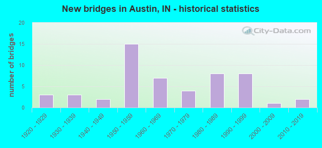
- New bridges - historical statistics
- 31920-1929
- 31930-1939
- 21940-1949
- 151950-1959
- 71960-1969
- 41970-1979
- 81980-1989
- 81990-1999
- 12000-2009
- 22010-2019

- Reconstructed bridges - Historical Statistics
- 41970-1979
- 121980-1989
- 41990-1999
- 52000-2009
- 32010-2019
- 12020-2022


- Bridge Condition - Deck
- 8.9%Very good
- 44.4%Good
- 28.9%Satisfactory
- 15.6%Fair
- 2.2%Poor

- Bridge Condition - Superstructure
- 8.9%Very good
- 37.8%Good
- 33.3%Satisfactory
- 15.6%Fair
- 4.4%Poor

- Bridge Condition - Substructure
- 4.4%Very good
- 48.9%Good
- 26.7%Satisfactory
- 17.8%Fair
- 2.2%Poor

- Bridge Condition - Channel
- 6.5%Very good
- 30.4%Good
- 45.7%Satisfactory
- 15.2%Fair
- 2.2%Poor

- Bridge Condition - Culverts
- 16.7%Very good
- 33.3%Good
- 50.0%Satisfactory
Find on map >> Show street view
Structure Number: 7200028, Location: 00.73 N OF SR 256 (Lat: 38.754011, Lng: -85.757881), Route carried "on" structure: County highway , Year Built: 1985, Status: Open, Structure Length: 0.98m (3.22ft), Average Daily Traffic: 525 (year 2021), Truck Traffic: 5%, Average Future Daily Traffic: 900 (year 2041), Design Load: HS 20, Features Intersected: HUTTO CREEK, Facility Carried by Structure: BOGARDUS ROAD
Minimum Vertical Clearance: 30+ m (98+ ft), Kilometerpoint: 0.000, Lanes on structure: 2, Owner: County Highway Agency, Approaching Roadway Width: 6.1m (20.0ft), Material/Design: Prestressed concrete, Design/Construction: Box Beam or Girders - Multiple, Number Of Spans In Main Unit: 1, Length of Maximum Span: 8.8m (28.9ft), Curb-To-Curb Width: 7.3m (24.0ft), Out-to-Out Width: 7.3m (24.0ft)
Condition: Deck: Satisfactory, Superstructure: Satisfactory, Substructure: Fair, Channel: Fair, Operating Rating: 52.7 metric tons, Method Used To Determine Operating Rating: Load and Resistance Factor (LRFR), Inventory Rating: 41.6 metric tons, Method Used To Determine Inventory Rating: Load and Resistance Factor (LRFR), Structural Evaluation: Somewhat better than minimum adequacy, Deck Geometry: Meets minimum limits, Waterway Adequacy: Better than present minimum criteria, Approach Roadway Alignment: Equal to present desirable criteria, Designated Inspection Frequency: Every 24 months, Inspection Date: September 2021, Deck Structure Type: Concrete Precast Panels, Wearing Surface/Protective System: Wearing Surface: Bituminous
Find on map >> Show street view
Structure Number: 7200029, Location: 00.47 N OF HARROD RD (Lat: 38.779031, Lng: -85.758161), Route carried "on" structure: County highway , Year Built: 1999, Status: Open, Structure Length: 1.22m (4.00ft), Average Daily Traffic: 525 (year 2021), Truck Traffic: 5%, Average Future Daily Traffic: 925 (year 2041), Features Intersected: WHITE OAK BRANCH, Facility Carried by Structure: BOGARDUS ROAD
Minimum Vertical Clearance: 30+ m (98+ ft), Kilometerpoint: 0.000, Lanes on structure: 2, Owner: County Highway Agency, Approaching Roadway Width: 5.5m (18.0ft), Material/Design: Aluminum, Iron, Design/Construction: Culvert, Number Of Spans In Main Unit: 1, Length of Maximum Span: 8.2m (26.9ft), Curb-To-Curb Width: 6.1m (20.0ft), Out-to-Out Width: 7.9m (25.9ft)
Condition: Channel: Satisfactory, Culverts: Good, Operating Rating: 44.5 metric tons, Method Used To Determine Operating Rating: Load and Resistance Factor (LRFR), Inventory Rating: 28.9 metric tons, Method Used To Determine Inventory Rating: Load and Resistance Factor (LRFR), Structural Evaluation: Better than present minimum criteria, Deck Geometry: High priority of corrective action, Waterway Adequacy: Somewhat better than minimum adequacy, Approach Roadway Alignment: Equal to present desirable criteria, Designated Inspection Frequency: Every 24 months, Inspection Date: September 2021, Wearing Surface/Protective System: Wearing Surface: Bituminous
Find on map >> Show street view
Structure Number: 720003, Location: 00.42 N OARD SPRING RD (Lat: 38.800011, Lng: -85.758331), Route carried "on" structure: County highway , Year Built: 1987, Status: Open, Structure Length: 1.55m (5.09ft), Average Daily Traffic: 125 (year 2021), Truck Traffic: 5%, Average Future Daily Traffic: 230 (year 2041), Features Intersected: QUICK CREEK, Facility Carried by Structure: BOGARDUS ROAD
Minimum Vertical Clearance: 30+ m (98+ ft), Kilometerpoint: 0.000, Lanes on structure: 2, Owner: County Highway Agency, Approaching Roadway Width: 6.1m (20.0ft), Skew: 1 degrees, Material/Design: Prestressed concrete, Design/Construction: Box Beam or Girders - Multiple, Number Of Spans In Main Unit: 1, Length of Maximum Span: 14.2m (46.6ft), Curb-To-Curb Width: 7.3m (24.0ft), Out-to-Out Width: 7.4m (24.3ft)
Condition: Deck: Good, Superstructure: Good, Substructure: Fair, Channel: Fair, Operating Rating: 48.8 metric tons, Method Used To Determine Operating Rating: Load and Resistance Factor (LRFR), Inventory Rating: 39.8 metric tons, Method Used To Determine Inventory Rating: Load and Resistance Factor (LRFR), Structural Evaluation: Somewhat better than minimum adequacy, Deck Geometry: Somewhat better than minimum adequacy, Waterway Adequacy: Meets minimum limits, Approach Roadway Alignment: Equal to present minimum criteria, Designated Inspection Frequency: Every 24 months, Inspection Date: September 2021, Deck Structure Type: Concrete Precast Panels, Wearing Surface/Protective System: Wearing Surface: Bituminous
Find on map >> Show street view
Structure Number: 7200033, Location: 00.76 W OF BOATMAN RD (Lat: 38.707300, Lng: -85.827161), Route carried "on" structure: County highway , Year Built: 1965, Year Reconstructed: 1992, Status: Open, Structure Length: 1.89m (6.20ft), Average Daily Traffic: 100 (year 2021), Truck Traffic: 5%, Average Future Daily Traffic: 125 (year 2041), Features Intersected: BIG OX CREEK, Facility Carried by Structure: MOONGLOW ROAD
Minimum Vertical Clearance: 30+ m (98+ ft), Kilometerpoint: 0.000, Lanes on structure: 2, Owner: County Highway Agency, Approaching Roadway Width: 4.9m (16.1ft), Material/Design: Steel, Design/Construction: Stringer/Multi-beam, Number Of Spans In Main Unit: 1, Length of Maximum Span: 18.0m (59.1ft), Curb-To-Curb Width: 6.1m (20.0ft), Out-to-Out Width: 6.1m (20.0ft)
Condition: Deck: Good, Superstructure: Good, Substructure: Satisfactory, Channel: Satisfactory, Operating Rating: 85.7 metric tons, Method Used To Determine Operating Rating: Load Factor (LF), Inventory Rating: 51.3 metric tons, Method Used To Determine Inventory Rating: Load Factor (LF), Structural Evaluation: Equal to present minimum criteria, Deck Geometry: Somewhat better than minimum adequacy, Waterway Adequacy: Meets minimum limits, Approach Roadway Alignment: Equal to present minimum criteria, Designated Inspection Frequency: Every 24 months, Inspection Date: September 2021, Deck Structure Type: Concrete Cast-file-Place, Wearing Surface/Protective System: Wearing Surface: Monolithic Concrete
Find on map >> Show street view
Structure Number: 7200035, Location: 00.90 E FINLEY FIREHOUSE (Lat: 38.719811, Lng: -85.839181), Route carried "on" structure: County highway , Year Built: 1982, Status: Open, Structure Length: 1.92m (6.30ft), Average Daily Traffic: 100 (year 2021), Truck Traffic: 5%, Average Future Daily Traffic: 125 (year 2041), Features Intersected: OX DITCH, Facility Carried by Structure: THOMASTOWN RD
Minimum Vertical Clearance: 30+ m (98+ ft), Kilometerpoint: 0.000, Lanes on structure: 2, Owner: County Highway Agency, Approaching Roadway Width: 4.9m (16.1ft), Skew: 4 degrees, Material/Design: Prestressed concrete, Design/Construction: Box Beam or Girders - Multiple, Number Of Spans In Main Unit: 1, Length of Maximum Span: 17.2m (56.4ft), Curb-To-Curb Width: 7.2m (23.6ft), Out-to-Out Width: 7.4m (24.3ft)
Condition: Deck: Good, Superstructure: Good, Substructure: Satisfactory, Channel: Fair, Operating Rating: 42.4 metric tons, Method Used To Determine Operating Rating: Load and Resistance Factor (LRFR), Inventory Rating: 34.5 metric tons, Method Used To Determine Inventory Rating: Load and Resistance Factor (LRFR), Structural Evaluation: Equal to present minimum criteria, Deck Geometry: Somewhat better than minimum adequacy, Waterway Adequacy: Equal to present minimum criteria, Approach Roadway Alignment: Equal to present minimum criteria, Designated Inspection Frequency: Every 24 months, Inspection Date: September 2021, Deck Structure Type: Concrete Precast Panels
Find on map >> Show street view
Structure Number: 7200036, Location: 00.62 S OF YORK RD (Lat: 38.726811, Lng: -85.833569), Route carried "on" structure: County highway , Year Built: 1960, Status: Open, Structure Length: 1.83m (6.00ft), Average Daily Traffic: 100 (year 2021), Truck Traffic: 5%, Average Future Daily Traffic: 120 (year 2041), Features Intersected: STUCKER DITCH, Facility Carried by Structure: THOMASTOWN RD
Minimum Vertical Clearance: 30+ m (98+ ft), Kilometerpoint: 0.000, Lanes on structure: 2, Owner: County Highway Agency, Approaching Roadway Width: 5.2m (17.1ft), Skew: 1 degrees, Material/Design: Steel, Design/Construction: Stringer/Multi-beam, Number Of Spans In Main Unit: 1, Length of Maximum Span: 17.3m (56.8ft), Curb-To-Curb Width: 7.1m (23.3ft), Out-to-Out Width: 7.2m (23.6ft)
Condition: Deck: Satisfactory, Superstructure: Fair, Substructure: Fair, Channel: Satisfactory, Operating Rating: 43.8 metric tons, Method Used To Determine Operating Rating: Load Factor (LF), Inventory Rating: 26.2 metric tons, Method Used To Determine Inventory Rating: Load Factor (LF), Structural Evaluation: Somewhat better than minimum adequacy, Deck Geometry: Somewhat better than minimum adequacy, Waterway Adequacy: Meets minimum limits, Approach Roadway Alignment: High priority of corrective action, Designated Inspection Frequency: Every 24 months, Inspection Date: September 2021, Deck Structure Type: Concrete Cast-file-Place, Wearing Surface/Protective System: Wearing Surface: Monolithic Concrete
Find on map >> Show street view
Structure Number: 7200037, Location: 00.55 N THOMASTOWN RD (Lat: 38.718281, Lng: -85.850900), Route carried "on" structure: County highway , Year Built: 1920, Status: Open, Structure Length: 1.02m (3.35ft), Average Daily Traffic: 10 (year 2021), Truck Traffic: 5%, Average Future Daily Traffic: 20 (year 2041), Features Intersected: OX DITCH, Facility Carried by Structure: FIREHOUSE RD
Minimum Vertical Clearance: 30+ m (98+ ft), Kilometerpoint: 0.000, Lanes on structure: 1, Owner: County Highway Agency, Approaching Roadway Width: 3.4m (11.2ft), Material/Design: Concrete, Design/Construction: Girder and Floorbeam System, Number Of Spans In Main Unit: 1, Length of Maximum Span: 9.6m (31.5ft), Curb-To-Curb Width: 4.2m (13.8ft), Out-to-Out Width: 5.0m (16.4ft)
Condition: Deck: Fair, Superstructure: Poor, Substructure: Fair, Channel: Fair, Operating Rating: 32.7 metric tons, Method Used To Determine Operating Rating: Field evaluation and documented engineering judgment, Inventory Rating: 32.7 metric tons, Method Used To Determine Inventory Rating: Field evaluation and documented engineering judgment, Structural Evaluation: Meets minimum limits, Deck Geometry: Somewhat better than minimum adequacy, Waterway Adequacy: Meets minimum limits, Approach Roadway Alignment: Equal to present desirable criteria, Length Of Structure Improvement: 1.98m (6.50ft), Designated Inspection Frequency: Every 12 months, Inspection Date: September 2021, Bridge Improvement Cost: $300,000, Roadway Improvement Cost: $150,000, Total Project Cost: $450,000 ( Estimate for 2021), Deck Structure Type: Concrete Cast-file-Place, Wearing Surface/Protective System: Wearing Surface: Gravel
Find on map >> Show street view
Structure Number: 7200074, Location: 00.15 S OF YORK RD (Lat: 38.733969, Lng: -85.800311), Route carried "on" structure: County highway , Year Built: 2002, Status: Open, Structure Length: 1.01m (3.31ft), Average Daily Traffic: 100 (year 2021), Truck Traffic: 5%, Average Future Daily Traffic: 150 (year 2041), Design Load: HS 20, Features Intersected: HUTTO CREEK, Facility Carried by Structure: RAILROAD ST
Minimum Vertical Clearance: 30+ m (98+ ft), Kilometerpoint: 0.000, Lanes on structure: 2, Owner: County Highway Agency, Approaching Roadway Width: 4.6m (15.1ft), Skew: 2 degrees, Material/Design: Prestressed concrete, Design/Construction: Box Beam or Girders - Multiple, Number Of Spans In Main Unit: 1, Length of Maximum Span: 9.8m (32.2ft), Curb-To-Curb Width: 7.2m (23.6ft), Out-to-Out Width: 7.4m (24.3ft)
Condition: Deck: Good, Superstructure: Good, Substructure: Good, Channel: Satisfactory, Operating Rating: 54.3 metric tons, Method Used To Determine Operating Rating: Load and Resistance Factor (LRFR), Inventory Rating: 40.6 metric tons, Method Used To Determine Inventory Rating: Load and Resistance Factor (LRFR), Structural Evaluation: Better than present minimum criteria, Deck Geometry: Somewhat better than minimum adequacy, Waterway Adequacy: Equal to present minimum criteria, Approach Roadway Alignment: Equal to present desirable criteria, Designated Inspection Frequency: Every 24 months, Inspection Date: September 2021, Deck Structure Type: Concrete Precast Panels
Find on map >> Show street view
Structure Number: 720008, Location: 00.36 N OF SR 256 (Lat: 38.748831, Lng: -85.739261), Route carried "on" structure: County highway , Year Built: 1990, Status: Open, Structure Length: 0.67m (2.20ft), Average Daily Traffic: 525 (year 2021), Truck Traffic: 5%, Average Future Daily Traffic: 950 (year 2041), Features Intersected: HUTTO CREEK, Facility Carried by Structure: TERRY RD
Minimum Vertical Clearance: 30+ m (98+ ft), Kilometerpoint: 0.000, Lanes on structure: 2, Owner: County Highway Agency, Approaching Roadway Width: 6.1m (20.0ft), Material/Design: Concrete, Design/Construction: Slab, Number Of Spans In Main Unit: 1, Length of Maximum Span: 6.1m (20.0ft), Curb-To-Curb Width: 7.3m (24.0ft), Out-to-Out Width: 7.3m (24.0ft)
Condition: Deck: Good, Superstructure: Good, Substructure: Good, Channel: Good, Operating Rating: 32.7 metric tons, Method Used To Determine Operating Rating: Field evaluation and documented engineering judgment, Inventory Rating: 32.7 metric tons, Method Used To Determine Inventory Rating: Field evaluation and documented engineering judgment, Structural Evaluation: Better than present minimum criteria, Deck Geometry: Meets minimum limits, Waterway Adequacy: Better than present minimum criteria, Approach Roadway Alignment: Equal to present minimum criteria, Designated Inspection Frequency: Every 24 months, Inspection Date: September 2021, Deck Structure Type: Concrete Cast-file-Place, Wearing Surface/Protective System: Wearing Surface: Bituminous
Find on map >> Show street view
Structure Number: 7200081, Location: 00.50 E FINLEY FIREHOUSE (Lat: 38.714889, Lng: -85.844561), Route carried "on" structure: County highway , Year Built: 1967, Status: Posted for load, Structure Length: 0.66m (2.17ft), Average Daily Traffic: 100 (year 2021), Truck Traffic: 2%, Average Future Daily Traffic: 150 (year 2041), Features Intersected: STOP RUN, Facility Carried by Structure: THOMASTOWN RD
Minimum Vertical Clearance: 30+ m (98+ ft), Kilometerpoint: 0.000, Lanes on structure: 2, Owner: County Highway Agency, Approaching Roadway Width: 4.3m (14.1ft), Material/Design: Steel, Design/Construction: Stringer/Multi-beam, Number Of Spans In Main Unit: 1, Length of Maximum Span: 6.1m (20.0ft), Curb or Sidewalk Widths: Left: 0.2m (0.7ft), Right: 0.2m (0.7ft), Curb-To-Curb Width: 6.1m (20.0ft), Out-to-Out Width: 6.6m (21.7ft)
Condition: Deck: Satisfactory, Superstructure: Satisfactory, Substructure: Satisfactory, Channel: Satisfactory, Operating Rating: 14.3 metric tons, Method Used To Determine Operating Rating: Load Factor (LF), Inventory Rating: 8.6 metric tons, Method Used To Determine Inventory Rating: Load Factor (LF), Structural Evaluation: High priority of replacement, Deck Geometry: Somewhat better than minimum adequacy, Waterway Adequacy: Somewhat better than minimum adequacy, Approach Roadway Alignment: Equal to present minimum criteria, Bridge Posting: Required (Relationship of Operating Rating to Maximum Legal Load: > 39.9% below), Length Of Structure Improvement: 0.91m (2.99ft), Designated Inspection Frequency: Every 24 months, Inspection Date: September 2021, Bridge Improvement Cost: $200,000, Roadway Improvement Cost: $100,000, Total Project Cost: $300,000 ( Estimate for 2021), Deck Structure Type: Concrete Cast-file-Place, Wearing Surface/Protective System: Wearing Surface: Bituminous
Find on map >> Show street view
Structure Number: 7200089, Location: 00.18 W OF US 31 (Lat: 38.735911, Lng: -85.802539), Route carried "on" structure: City street , Year Built: 1995, Status: Open, Structure Length: 0.76m (2.49ft), Average Daily Traffic: 270 (year 2021), Truck Traffic: 5%, Average Future Daily Traffic: 480 (year 2041), Features Intersected: DRAINAGE DITCH, Facility Carried by Structure: YORK ROAD
Minimum Vertical Clearance: 30+ m (98+ ft), Kilometerpoint: 0.000, Lanes on structure: 2, Owner: County Highway Agency, Maintenance Responsibility: City or Municipal Highway Agency, Approaching Roadway Width: 4.9m (16.1ft), Skew: 1 degrees, Material/Design: Concrete, Design/Construction: Culvert, Number Of Spans In Main Unit: 3, Length of Maximum Span: 1.8m (5.9ft), Curb-To-Curb Width: 9.8m (32.2ft), Out-to-Out Width: 9.8m (32.2ft)
Condition: Channel: Satisfactory, Culverts: Good, Operating Rating: 32.7 metric tons, Method Used To Determine Operating Rating: Field evaluation and documented engineering judgment, Inventory Rating: 32.7 metric tons, Method Used To Determine Inventory Rating: Field evaluation and documented engineering judgment, Structural Evaluation: Better than present minimum criteria, Deck Geometry: Better than present minimum criteria, Waterway Adequacy: Somewhat better than minimum adequacy, Approach Roadway Alignment: Equal to present minimum criteria, Designated Inspection Frequency: Every 24 months, Inspection Date: September 2021, Wearing Surface/Protective System: Wearing Surface: Other
Find on map >> Show street view
Structure Number: 72001, Location: 00.43 W OF BOGARDUS RD (Lat: 38.786719, Lng: -85.766139), Route carried "on" structure: County highway 24, Year Built: 2019, Status: Open, Structure Length: 1.37m (4.49ft), Average Daily Traffic: 600 (year 2021), Truck Traffic: 5%, Average Future Daily Traffic: 1,060 (year 2041), Design Load: HL 93, Features Intersected: WHITE OAK BRANCH, Facility Carried by Structure: CROTHERSVILLE ROAD
Minimum Vertical Clearance: 30+ m (98+ ft), Kilometerpoint: 0.000, Lanes on structure: 2, Owner: County Highway Agency, Approaching Roadway Width: 5.5m (18.0ft), Skew: 4 degrees, Material/Design: Steel, Design/Construction: Stringer/Multi-beam, Number Of Spans In Main Unit: 1, Length of Maximum Span: 13.0m (42.7ft), Curb-To-Curb Width: 7.3m (24.0ft), Out-to-Out Width: 7.4m (24.3ft)
Condition: Deck: Very good, Superstructure: Very good, Substructure: Very good, Channel: Satisfactory, Operating Rating: 79.1 metric tons, Method Used To Determine Operating Rating: Load and Resistance Factor (LRFR), Inventory Rating: 76.3 metric tons, Method Used To Determine Inventory Rating: Load and Resistance Factor (LRFR), Structural Evaluation: Equal to present desirable criteria, Deck Geometry: Meets minimum limits, Waterway Adequacy: Somewhat better than minimum adequacy, Approach Roadway Alignment: Equal to present desirable criteria, Designated Inspection Frequency: Every 24 months, Inspection Date: September 2021, Deck Structure Type: Concrete Cast-file-Place, Wearing Surface/Protective System: Wearing Surface: Monolithic Concrete
Find on map >> Show street view
Structure Number: 3086, Location: 00.77 W US 31 (Lat: 38.740750, Lng: -85.818550), Route carried "under" structure: Interstate 65, Year Built: 1959, Structure Length: 0. m, Average Daily Traffic: 20,763 (year 2004), Truck Traffic: 10%, Features Intersected: I-65 NBL, Facility Carried by Structure: SR 256
Minimum Vertical Clearance: 5.05m (16.57ft), Kilometerpoint: 53.913, Lanes on structure: 4, Lanes under structure: 5, Material/Design: Steel continuous, Design/Construction: Stringer/Multi-beam, Length of Maximum Span: 22.0m (72.2ft)
Find on map >> Show street view
Structure Number: 3086, Location: 00.77 W US 31 (Lat: 38.740750, Lng: -85.818550), Route carried "under" structure: Interstate 65, Year Built: 1959, Structure Length: 0. m, Average Daily Traffic: 20,763 (year 2004), Truck Traffic: 10%, Features Intersected: I-65 SBL, Facility Carried by Structure: SR 256
Minimum Vertical Clearance: 5.03m (16.50ft), Kilometerpoint: 53.913, Lanes on structure: 4, Lanes under structure: 5, Material/Design: Steel continuous, Design/Construction: Stringer/Multi-beam, Length of Maximum Span: 22.0m (72.2ft)