Bridge Statistics for Bossier City, Louisiana (LA)
Condition, Traffic, Stress, Structural Evaluation, Project Costs
- National Bridge Inventory (NBI) Statistics
- 166Number of bridges
- 2,923ft / 891mTotal length
- $50,667,000Total costs
- 2,836,776Total average daily traffic
- 283,703Total average daily truck traffic
- National Bridge Inventory (NBI) Registered Bridges for Bossier City
- No street view available for this location
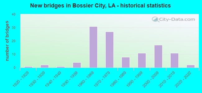
- New bridges - historical statistics
- 11920-1929
- 21930-1939
- 11940-1949
- 41950-1959
- 311960-1969
- 271970-1979
- 81980-1989
- 111990-1999
- 172000-2009
- 112010-2019
- 22020-2022
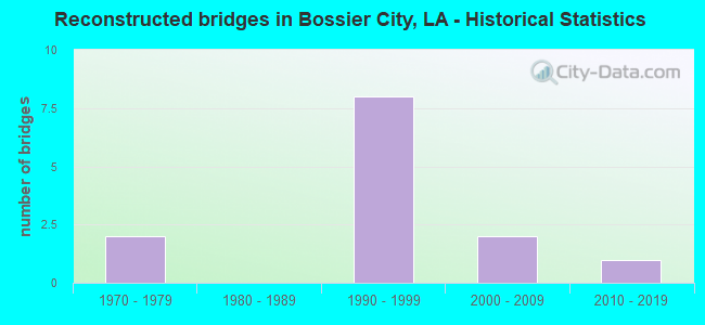
- Reconstructed bridges - Historical Statistics
- 21970-1979
- 01980-1989
- 81990-1999
- 22000-2009
- 12010-2019
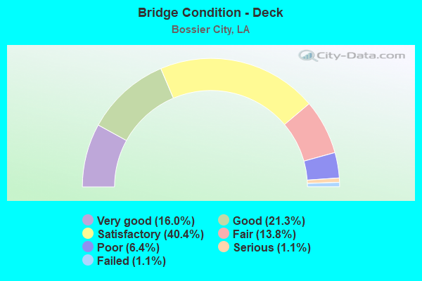
- Bridge Condition - Deck
- 16.0%Very good
- 21.3%Good
- 40.4%Satisfactory
- 13.8%Fair
- 6.4%Poor
- 1.1%Serious
- 1.1%Failed
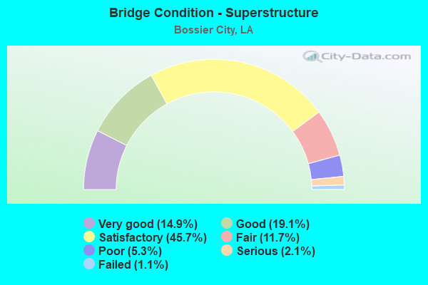
- Bridge Condition - Superstructure
- 14.9%Very good
- 19.1%Good
- 45.7%Satisfactory
- 11.7%Fair
- 5.3%Poor
- 2.1%Serious
- 1.1%Failed
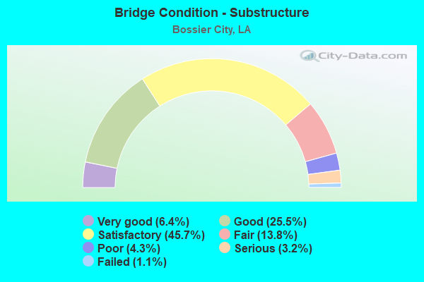
- Bridge Condition - Substructure
- 6.4%Very good
- 25.5%Good
- 45.7%Satisfactory
- 13.8%Fair
- 4.3%Poor
- 3.2%Serious
- 1.1%Failed
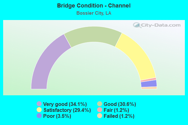
- Bridge Condition - Channel
- 34.1%Very good
- 30.6%Good
- 29.4%Satisfactory
- 1.2%Fair
- 3.5%Poor
- 1.2%Failed
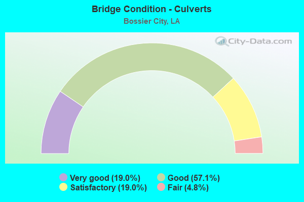
- Bridge Condition - Culverts
- 19.0%Very good
- 57.1%Good
- 19.0%Satisfactory
- 4.8%Fair
Find on map >> Show street view
Structure Number: 40808080600981, Location: .98 MI EAST OF LA 72 (Lat: 32.526489, Lng: -93.676400), Route carried "on" structure: State highway 7822, Year Built: 1970, Status: Posted for load, Structure Length: 3.51m (11.52ft), Average Daily Traffic: 6,300 (year 2016), Truck Traffic: 10%, Average Future Daily Traffic: 3,180 (year 2036), Design Load: HS 20, Features Intersected: MACKS BAYOU
Minimum Vertical Clearance: 30+ m (98+ ft), Kilometerpoint: 1.479, Lanes on structure: 2, Owner: State Highway Agency, Approaching Roadway Width: 11.0m (36.1ft), Material/Design: Concrete, Design/Construction: Slab, Number Of Spans In Main Unit: 6, Length of Maximum Span: 5.8m (19.0ft), Curb-To-Curb Width: 8.7m (28.5ft), Out-to-Out Width: 10.4m (34.1ft)
Condition: Deck: Serious, Superstructure: Serious, Substructure: Serious, Channel: Fair, Operating Rating: 12.3 metric tons, Method Used To Determine Operating Rating: Load and Resistance Factor Rating (LRFR) rating reported by rating factor(RF) method using HL-93 loadings, Inventory Rating: 9.4 metric tons, Method Used To Determine Inventory Rating: Load and Resistance Factor Rating (LRFR) rating reported by rating factor(RF) method using HL-93 loadings, Structural Evaluation: High priority of replacement, Deck Geometry: High priority of replacement, Waterway Adequacy: Equal to present minimum criteria, Approach Roadway Alignment: Somewhat better than minimum adequacy, Bridge Posting: Required (Relationship of Operating Rating to Maximum Legal Load: 30.0 - 39.9% below), Length Of Structure Improvement: 4.39m (14.40ft), Designated Inspection Frequency: Every 24 months, Other Special Inspection Frequency: Every 12 months, Inspection Date: November 2021, Other Special Inspection Date: November 2020, Bridge Improvement Cost: $374,000, Total Project Cost: $561,000 ( Estimate for 2016), Deck Structure Type: Concrete Precast Panels, Wearing Surface/Protective System: Wearing Surface: Bituminous
Find on map >> Show street view
Structure Number: 40808080702231, Location: 0.1 MI NORTH OF LA 72 (Lat: 32.522400, Lng: -93.697100), Route carried "on" structure: State highway 3105, Year Built: 1975, Year Reconstructed: 1984, Status: Open, Structure Length: 1.83m (6.00ft), Average Daily Traffic: 26,200 (year 2016), Truck Traffic: 8%, Average Future Daily Traffic: 13,680 (year 2036), Design Load: HS 20, Features Intersected: COOPERS BAYOU
Minimum Vertical Clearance: 30+ m (98+ ft), Kilometerpoint: 2.911, Lanes on structure: 4, Base Highway Network: Yes (Inventory Route: 808-07-1, Subroute: 10), Owner: State Highway Agency, Approaching Roadway Width: 20.7m (67.9ft), Skew: 27 degrees, Material/Design: Concrete, Design/Construction: Slab, Number Of Spans In Main Unit: 3, Length of Maximum Span: 6.1m (20.0ft), Curb or Sidewalk Widths: Left: 2.5m (8.2ft), Right: 2.5m (8.2ft), Curb-To-Curb Width: 20.8m (68.2ft), Out-to-Out Width: 26.3m (86.3ft)
Condition: Deck: Fair, Superstructure: Fair, Substructure: Fair, Channel: Very good, Operating Rating: 71.7 metric tons, Method Used To Determine Operating Rating: Load Factor (LF), Inventory Rating: 42.6 metric tons, Method Used To Determine Inventory Rating: Load Factor (LF), Structural Evaluation: Somewhat better than minimum adequacy, Deck Geometry: Superior to present desirable criteria, Waterway Adequacy: Equal to present minimum criteria, Approach Roadway Alignment: Equal to present desirable criteria, Designated Inspection Frequency: Every 24 months, Inspection Date: November 2020, Deck Structure Type: Concrete Cast-file-Place
Find on map >> Show street view
Structure Number: 40808080703871, Location: 1.4M NORTH OF I-20 (Lat: 32.542900, Lng: -93.708500), Route carried "on" structure: State highway 3105, Year Built: 1992, Status: Open, Structure Length: 1.13m (3.71ft), Average Daily Traffic: 33,400 (year 2016), Truck Traffic: 8%, Average Future Daily Traffic: 19,500 (year 2036), Design Load: HS 20, Features Intersected: DRAIN
Minimum Vertical Clearance: 30+ m (98+ ft), Kilometerpoint: 5.498, Lanes on structure: 5, Base Highway Network: Yes (Inventory Route: 808-07-1, Subroute: 10), Owner: State Highway Agency, Approaching Roadway Width: 19.8m (65.0ft), Skew: 20 degrees, Material/Design: Concrete, Design/Construction: Culvert, Number Of Spans In Main Unit: 5, Length of Maximum Span: 2.1m (6.9ft)
Condition: Channel: Good, Culverts: Good, Operating Rating: 42.1 metric tons, Method Used To Determine Operating Rating: Load and Resistance Factor Rating (LRFR) rating reported by rating factor(RF) method using HL-93 loadings, Inventory Rating: 32.4 metric tons, Method Used To Determine Inventory Rating: Load and Resistance Factor Rating (LRFR) rating reported by rating factor(RF) method using HL-93 loadings, Structural Evaluation: Better than present minimum criteria, Waterway Adequacy: Better than present minimum criteria, Approach Roadway Alignment: Equal to present desirable criteria, Designated Inspection Frequency: Every 24 months, Inspection Date: November 2020, Deck Structure Type: Concrete Cast-file-Place
Find on map >> Show street view
Structure Number: 40808080705191, Location: 0.9 MI. N. OF I-220 (Lat: 32.561450, Lng: -93.711100), Route carried "on" structure: State highway 310, Year Built: 2005, Status: Open, Structure Length: 3.05m (10.01ft), Average Daily Traffic: 33,400 (year 2016), Truck Traffic: 10%, Average Future Daily Traffic: 19,500 (year 2036), Design Load: HS 20, Features Intersected: BENOIT BAYOU
Minimum Vertical Clearance: 30+ m (98+ ft), Kilometerpoint: 7.572, Lanes on structure: 4, Owner: State Highway Agency, Approaching Roadway Width: 20.1m (65.9ft), Material/Design: Concrete, Design/Construction: Slab, Number Of Spans In Main Unit: 5, Length of Maximum Span: 6.1m (20.0ft), Curb or Sidewalk Widths: Left: 1.8m (5.9ft), Right: 1.8m (5.9ft), Curb-To-Curb Width: 20.1m (65.9ft), Out-to-Out Width: 24.4m (80.1ft)
Condition: Deck: Satisfactory, Superstructure: Satisfactory, Substructure: Good, Channel: Very good, Operating Rating: 45.4 metric tons, Method Used To Determine Operating Rating: Load and Resistance Factor Rating (LRFR) rating reported by rating factor(RF) method using HL-93 loadings, Inventory Rating: 35.0 metric tons, Method Used To Determine Inventory Rating: Load and Resistance Factor Rating (LRFR) rating reported by rating factor(RF) method using HL-93 loadings, Structural Evaluation: Equal to present minimum criteria, Deck Geometry: Better than present minimum criteria, Waterway Adequacy: Better than present minimum criteria, Approach Roadway Alignment: Equal to present desirable criteria, Designated Inspection Frequency: Every 24 months, Inspection Date: November 2021, Deck Structure Type: Concrete Cast-file-Place
Find on map >> Show street view
Structure Number: 40808080706041, Location: 1.7 MI N. OF I-220 (Lat: 32.573711, Lng: -93.713600), Route carried "on" structure: State highway 3105, Year Built: 2005, Status: Open, Structure Length: 2.44m (8.01ft), Average Daily Traffic: 33,400 (year 2016), Truck Traffic: 10%, Average Future Daily Traffic: 19,500 (year 2036), Design Load: HS 20, Features Intersected: DRAIN
Minimum Vertical Clearance: 30+ m (98+ ft), Kilometerpoint: 8.956, Lanes on structure: 4, Owner: State Highway Agency, Approaching Roadway Width: 20.1m (65.9ft), Material/Design: Concrete, Design/Construction: Slab, Number Of Spans In Main Unit: 4, Length of Maximum Span: 6.1m (20.0ft), Curb or Sidewalk Widths: Left: 1.8m (5.9ft), Right: 1.8m (5.9ft), Curb-To-Curb Width: 20.2m (66.3ft), Out-to-Out Width: 24.4m (80.1ft)
Condition: Deck: Satisfactory, Superstructure: Satisfactory, Substructure: Good, Channel: Very good, Operating Rating: 45.4 metric tons, Method Used To Determine Operating Rating: Load and Resistance Factor Rating (LRFR) rating reported by rating factor(RF) method using HL-93 loadings, Inventory Rating: 35.0 metric tons, Method Used To Determine Inventory Rating: Load and Resistance Factor Rating (LRFR) rating reported by rating factor(RF) method using HL-93 loadings, Structural Evaluation: Equal to present minimum criteria, Deck Geometry: Better than present minimum criteria, Waterway Adequacy: Better than present minimum criteria, Approach Roadway Alignment: Equal to present desirable criteria, Designated Inspection Frequency: Every 24 months, Inspection Date: November 2021, Deck Structure Type: Concrete Cast-file-Place
Find on map >> Show street view
Structure Number: 40832215933151, Location: 0.5 MI N OF LA 154 (Lat: 32.359369, Lng: -93.525631), Route carried "on" structure: County highway , Year Built: 1989, Status: Closed, Structure Length: 6.43m (21.10ft), Average Daily Traffic: 20 (year 2020), Average Future Daily Traffic: 18 (year 2036), Design Load: H 10, Features Intersected: Red Chute Bayou, Facility Carried by Structure: Elston Rd
Minimum Vertical Clearance: 30+ m (98+ ft), Kilometerpoint: 0.000, Lanes on structure: 2, Owner: County Highway Agency, Approaching Roadway Width: 7.0m (23.0ft), Material/Design: Wood or Timber, Design/Construction: Stringer/Multi-beam, Number Of Spans In Main Unit: 14, Length of Maximum Span: 4.6m (15.1ft), Curb-To-Curb Width: 7.5m (24.6ft), Out-to-Out Width: 8.0m (26.2ft)
Condition: Deck: Failed, Superstructure: Failed, Substructure: Failed, Channel: Satisfactory, Operating Rating: 6.3 metric tons, Method Used To Determine Operating Rating: Allowable Stress (AS), Inventory Rating: 4.5 metric tons, Method Used To Determine Inventory Rating: Allowable Stress (AS), Deck Geometry: Equal to present minimum criteria, Waterway Adequacy: Better than present minimum criteria, Approach Roadway Alignment: Equal to present desirable criteria, Bridge Posting: Required (Relationship of Operating Rating to Maximum Legal Load: > 39.9% below), Length Of Structure Improvement: 7.35m (24.11ft), Designated Inspection Frequency: Every 24 months, Underwater Inspection Frequency: Every 60 months, Other Special Inspection Frequency: Every 6 months, Inspection Date: December 2020, Underwater Inspection Date: November 2021, Other Special Inspection Date: December 2021, Bridge Improvement Cost: $438,000, Total Project Cost: $657,000 ( Estimate for 2016), Deck Structure Type: Wood or Timber, Wearing Surface/Protective System: Wearing Surface: Other
Find on map >> Show street view
Structure Number: 40832258933491, Location: 1.6 MI SOUTH OF LA 612 (Lat: 32.430311, Lng: -93.582300), Route carried "on" structure: County highway , Year Built: 1995, Status: Posted for load, Structure Length: 5.09m (16.70ft), Average Daily Traffic: 710 (year 2020), Average Future Daily Traffic: 180 (year 2036), Design Load: H 20, Features Intersected: Red Chute Bayou, Facility Carried by Structure: Caplis Sligo Rd
Minimum Vertical Clearance: 30+ m (98+ ft), Kilometerpoint: 0.000, Lanes on structure: 2, Base Highway Network: Yes, Owner: County Highway Agency, Approaching Roadway Width: 8.8m (28.9ft), Material/Design: Wood or Timber, Design/Construction: Stringer/Multi-beam, Number Of Spans In Main Unit: 11, Length of Maximum Span: 4.6m (15.1ft), Curb-To-Curb Width: 7.7m (25.3ft), Out-to-Out Width: 8.0m (26.2ft)
Condition: Deck: Poor, Superstructure: Serious, Substructure: Serious, Channel: Poor, Operating Rating: 25.4 metric tons, Method Used To Determine Operating Rating: Allowable Stress (AS), Inventory Rating: 19.0 metric tons, Method Used To Determine Inventory Rating: Allowable Stress (AS), Structural Evaluation: High priority of corrective action, Deck Geometry: Meets minimum limits, Waterway Adequacy: Equal to present minimum criteria, Approach Roadway Alignment: Equal to present minimum criteria, Length Of Structure Improvement: 6.00m (19.69ft), Designated Inspection Frequency: Every 24 months, Underwater Inspection Frequency: Every 24 months, Other Special Inspection Frequency: Every 12 months, Inspection Date: December 2020, Underwater Inspection Date: June 2021, Other Special Inspection Date: December 2021, Bridge Improvement Cost: $358,000, Total Project Cost: $537,000 ( Estimate for 2016), Deck Structure Type: Wood or Timber, Wearing Surface/Protective System: Wearing Surface: Bituminous
Find on map >> Show street view
Structure Number: 40832269933871, Location: 1.2 MI E OF HWY 71 (Lat: 32.451939, Lng: -93.647561), Route carried "on" structure: County highway , Year Built: 1979, Status: Open, Structure Length: 1.43m (4.69ft), Average Daily Traffic: 30 (year 2016), Average Future Daily Traffic: 18 (year 2036), Design Load: HS 20, Features Intersected: MACKS BAYOU, Facility Carried by Structure: Golden Meadows
Minimum Vertical Clearance: 30+ m (98+ ft), Kilometerpoint: 0.000, Lanes on structure: 2, Owner: City or Municipal Highway Agency, Approaching Roadway Width: 14.6m (47.9ft), Material/Design: Steel, Design/Construction: Culvert, Number Of Spans In Main Unit: 2, Length of Maximum Span: 4.9m (16.1ft), Curb or Sidewalk Widths: Left: 1.2m (3.9ft), Right: 1.2m (3.9ft), Curb-To-Curb Width: 9.0m (29.5ft), Out-to-Out Width: 15.2m (49.9ft)
Condition: Channel: Good, Culverts: Good, Operating Rating: 45.7 metric tons, Method Used To Determine Operating Rating: Load and Resistance Factor Rating (LRFR) rating reported by rating factor(RF) method using HL-93 loadings, Inventory Rating: 41.1 metric tons, Method Used To Determine Inventory Rating: Load and Resistance Factor Rating (LRFR) rating reported by rating factor(RF) method using HL-93 loadings, Structural Evaluation: Better than present minimum criteria, Deck Geometry: Better than present minimum criteria, Waterway Adequacy: Somewhat better than minimum adequacy, Approach Roadway Alignment: Equal to present minimum criteria, Designated Inspection Frequency: Every 24 months, Inspection Date: December 2020
Find on map >> Show street view
Structure Number: 40832270933511, Location: 0.1 MI E OF LA 612 (Lat: 32.450781, Lng: -93.584831), Route carried "on" structure: County highway , Year Built: 1989, Status: Open, Structure Length: 0.98m (3.22ft), Average Daily Traffic: 4,000 (year 2020), Average Future Daily Traffic: 630 (year 2036), Design Load: H 10, Features Intersected: Hogskin Lake Creek, Facility Carried by Structure: Sligo Rd
Minimum Vertical Clearance: 30+ m (98+ ft), Kilometerpoint: 0.000, Lanes on structure: 2, Owner: County Highway Agency, Approaching Roadway Width: 9.4m (30.8ft), Material/Design: Wood or Timber, Design/Construction: Stringer/Multi-beam, Number Of Spans In Main Unit: 2, Length of Maximum Span: 4.6m (15.1ft), Curb-To-Curb Width: 7.7m (25.3ft), Out-to-Out Width: 8.1m (26.6ft)
Condition: Deck: Very good, Superstructure: Good, Substructure: Satisfactory, Channel: Satisfactory, Operating Rating: 34.0 metric tons, Method Used To Determine Operating Rating: Allowable Stress (AS), Inventory Rating: 24.5 metric tons, Method Used To Determine Inventory Rating: Allowable Stress (AS), Structural Evaluation: Equal to present minimum criteria, Deck Geometry: High priority of replacement, Waterway Adequacy: Somewhat better than minimum adequacy, Approach Roadway Alignment: Equal to present desirable criteria, Length Of Structure Improvement: 1.62m (5.31ft), Designated Inspection Frequency: Every 24 months, Inspection Date: December 2020, Bridge Improvement Cost: $96,000, Total Project Cost: $144,000 ( Estimate for 2016), Deck Structure Type: Wood or Timber, Wearing Surface/Protective System: Wearing Surface: Bituminous
Find on map >> Show street view
Structure Number: 40832272933981, Location: 0.4 MI WEST OF US 71 (Lat: 32.453711, Lng: -93.664111), Route carried "on" structure: County highway , Year Built: 1998, Status: Open, Structure Length: 0.76m (2.49ft), Average Daily Traffic: 1,892 (year 2021), Average Future Daily Traffic: 2,081 (year 2041), Design Load: HS 20, Features Intersected: MACKS BAYOU, Facility Carried by Structure: Sunflower Rd
Minimum Vertical Clearance: 30+ m (98+ ft), Kilometerpoint: 0.000, Lanes on structure: 2, Base Highway Network: Yes, Owner: City or Municipal Highway Agency, Approaching Roadway Width: 7.3m (24.0ft), Material/Design: Concrete, Design/Construction: Culvert, Number Of Spans In Main Unit: 3, Length of Maximum Span: 2.4m (7.9ft), Curb-To-Curb Width: 9.9m (32.5ft), Out-to-Out Width: 14.3m (46.9ft)
Condition: Channel: Satisfactory, Culverts: Good, Operating Rating: 42.1 metric tons, Method Used To Determine Operating Rating: Load and Resistance Factor Rating (LRFR) rating reported by rating factor(RF) method using HL-93 loadings, Inventory Rating: 32.4 metric tons, Method Used To Determine Inventory Rating: Load and Resistance Factor Rating (LRFR) rating reported by rating factor(RF) method using HL-93 loadings, Structural Evaluation: Better than present minimum criteria, Deck Geometry: Somewhat better than minimum adequacy, Waterway Adequacy: Better than present minimum criteria, Approach Roadway Alignment: Equal to present desirable criteria, Designated Inspection Frequency: Every 24 months, Inspection Date: December 2020, Deck Structure Type: Concrete Cast-file-Place
Find on map >> Show street view
Structure Number: 40832313934301, Location: 0.2 MI N OF HWY 72 (Lat: 32.522269, Lng: -93.702411), Route carried "on" structure: County highway , Year Built: 1977, Status: Posted for load, Structure Length: 2.35m (7.71ft), Average Daily Traffic: 100 (year 2016), Average Future Daily Traffic: 60 (year 2036), Design Load: HS 20, Features Intersected: TRIB. TO MACKS BAYOU, Facility Carried by Structure: Village Rd
Minimum Vertical Clearance: 30+ m (98+ ft), Kilometerpoint: 0.000, Lanes on structure: 2, Owner: City or Municipal Highway Agency, Approaching Roadway Width: 7.9m (25.9ft), Material/Design: Concrete, Design/Construction: Slab, Number Of Spans In Main Unit: 4, Length of Maximum Span: 5.8m (19.0ft), Curb or Sidewalk Widths: Left: 0.0m, Right: 1.2m (3.9ft), Curb-To-Curb Width: 8.6m (28.2ft), Out-to-Out Width: 10.7m (35.1ft)
Condition: Deck: Satisfactory, Superstructure: Satisfactory, Substructure: Poor, Channel: Satisfactory, Operating Rating: 21.1 metric tons, Method Used To Determine Operating Rating: Load and Resistance Factor Rating (LRFR) rating reported by rating factor(RF) method using HL-93 loadings, Inventory Rating: 16.2 metric tons, Method Used To Determine Inventory Rating: Load and Resistance Factor Rating (LRFR) rating reported by rating factor(RF) method using HL-93 loadings, Structural Evaluation: Meets minimum limits, Deck Geometry: Better than present minimum criteria, Waterway Adequacy: Equal to present minimum criteria, Approach Roadway Alignment: Equal to present desirable criteria, Bridge Posting: Required (Relationship of Operating Rating to Maximum Legal Load: 20.0 - 29.9% below), Designated Inspection Frequency: Every 24 months, Other Special Inspection Frequency: Every 12 months, Inspection Date: December 2020, Other Special Inspection Date: December 2021, Deck Structure Type: Concrete Precast Panels
Find on map >> Show street view
Structure Number: 40832314934171, Location: 0.1 MI. NO. OF LA 78 (Lat: 32.523161, Lng: -93.694661), Route carried "on" structure: County highway , Year Built: 1960, Status: Posted for load, Structure Length: 1.74m (5.71ft), Average Daily Traffic: 568 (year 2021), Average Future Daily Traffic: 625 (year 2041), Design Load: HS 20, Features Intersected: MACKS BAYOU, Facility Carried by Structure: BAILEY DRIVE
Minimum Vertical Clearance: 30+ m (98+ ft), Kilometerpoint: 0.000, Lanes on structure: 2, Owner: City or Municipal Highway Agency, Approaching Roadway Width: 7.9m (25.9ft), Material/Design: Concrete, Design/Construction: Slab, Number Of Spans In Main Unit: 3, Length of Maximum Span: 5.8m (19.0ft), Curb-To-Curb Width: 7.4m (24.3ft), Out-to-Out Width: 8.4m (27.6ft)
Condition: Deck: Satisfactory, Superstructure: Satisfactory, Substructure: Poor, Channel: Good, Operating Rating: 20.1 metric tons, Method Used To Determine Operating Rating: Load and Resistance Factor Rating (LRFR) rating reported by rating factor(RF) method using HL-93 loadings, Inventory Rating: 15.6 metric tons, Method Used To Determine Inventory Rating: Load and Resistance Factor Rating (LRFR) rating reported by rating factor(RF) method using HL-93 loadings, Structural Evaluation: Meets minimum limits, Deck Geometry: Meets minimum limits, Waterway Adequacy: Better than present minimum criteria, Approach Roadway Alignment: Equal to present desirable criteria, Bridge Posting: Required (Relationship of Operating Rating to Maximum Legal Load: 10.0 - 19.9% below), Length Of Structure Improvement: 2.44m (8.01ft), Designated Inspection Frequency: Every 24 months, Other Special Inspection Frequency: Every 12 months, Inspection Date: December 2020, Other Special Inspection Date: December 2021, Bridge Improvement Cost: $145,000, Total Project Cost: $217,000 ( Estimate for 2016), Deck Structure Type: Concrete Precast Panels
Find on map >> Show street view
Structure Number: 40832325934141, Location: 1.3 MI EAST OF LA 3105 (Lat: 32.542661, Lng: -93.689989), Route carried "on" structure: County highway , Year Built: 1986, Status: Open, Structure Length: 2.90m (9.51ft), Average Daily Traffic: 4,137 (year 2021), Average Future Daily Traffic: 4,551 (year 2041), Design Load: HS 20, Features Intersected: TRIB. TO MACKS BAYOU, Facility Carried by Structure: Shed Rd
Minimum Vertical Clearance: 30+ m (98+ ft), Kilometerpoint: 0.000, Lanes on structure: 2, Owner: City or Municipal Highway Agency, Approaching Roadway Width: 10.4m (34.1ft), Material/Design: Concrete, Design/Construction: Slab, Number Of Spans In Main Unit: 5, Length of Maximum Span: 5.8m (19.0ft), Curb or Sidewalk Widths: Left: 1.2m (3.9ft), Right: 1.2m (3.9ft), Curb-To-Curb Width: 7.9m (25.9ft), Out-to-Out Width: 11.0m (36.1ft)
Condition: Deck: Satisfactory, Superstructure: Satisfactory, Substructure: Satisfactory, Channel: Good, Operating Rating: 34.3 metric tons, Method Used To Determine Operating Rating: Load and Resistance Factor Rating (LRFR) rating reported by rating factor(RF) method using HL-93 loadings, Inventory Rating: 26.6 metric tons, Method Used To Determine Inventory Rating: Load and Resistance Factor Rating (LRFR) rating reported by rating factor(RF) method using HL-93 loadings, Structural Evaluation: Equal to present minimum criteria, Deck Geometry: High priority of corrective action, Waterway Adequacy: Better than present minimum criteria, Approach Roadway Alignment: Equal to present desirable criteria, Length Of Structure Improvement: 3.72m (12.20ft), Designated Inspection Frequency: Every 24 months, Inspection Date: December 2020, Bridge Improvement Cost: $222,000, Total Project Cost: $333,000 ( Estimate for 2016), Deck Structure Type: Concrete Cast-file-Place
Find on map >> Show street view
Structure Number: 40832333934071, Location: 1.5 MI NORTH OF US 80 (Lat: 32.555061, Lng: -93.677511), Route carried "on" structure: County highway , Year Built: 1986, Year Reconstructed: 2012, Status: Open, Structure Length: 2.32m (7.61ft), Average Daily Traffic: 14,078 (year 2021), Average Future Daily Traffic: 15,486 (year 2041), Design Load: HS 20, Features Intersected: MACKS BAYOU, Facility Carried by Structure: Swan Lake Rd
Minimum Vertical Clearance: 30+ m (98+ ft), Kilometerpoint: 0.000, Lanes on structure: 5, Owner: City or Municipal Highway Agency, Approaching Roadway Width: 26.2m (86.0ft), Skew: 30 degrees, Material/Design: Concrete, Design/Construction: Slab, Number Of Spans In Main Unit: 4, Length of Maximum Span: 5.8m (19.0ft), Curb-To-Curb Width: 23.7m (77.8ft), Out-to-Out Width: 24.7m (81.0ft)
Condition: Deck: Good, Superstructure: Good, Substructure: Good, Channel: Very good, Operating Rating: 52.5 metric tons, Method Used To Determine Operating Rating: Load and Resistance Factor Rating (LRFR) rating reported by rating factor(RF) method using HL-93 loadings, Inventory Rating: 40.5 metric tons, Method Used To Determine Inventory Rating: Load and Resistance Factor Rating (LRFR) rating reported by rating factor(RF) method using HL-93 loadings, Structural Evaluation: Better than present minimum criteria, Deck Geometry: Better than present minimum criteria, Waterway Adequacy: Equal to present desirable criteria, Approach Roadway Alignment: Equal to present desirable criteria, Designated Inspection Frequency: Every 24 months, Inspection Date: December 2020, Deck Structure Type: Concrete Cast-file-Place, Wearing Surface/Protective System: Wearing Surface: Monolithic Concrete
Find on map >> Show street view
Structure Number: 40832336934241, Location: 00.17 MILES EAST OF LA 31 (Lat: 32.560119, Lng: -93.708081), Route carried "on" structure: County highway , Year Built: 2007, Status: Open, Structure Length: 2.29m (7.51ft), Average Daily Traffic: 7,489 (year 2021), Truck Traffic: 10%, Average Future Daily Traffic: 8,238 (year 2041), Design Load: HS 20, Features Intersected: BENOIT BAYOU, Facility Carried by Structure: Beene Blvd
Minimum Vertical Clearance: 30+ m (98+ ft), Kilometerpoint: 0.000, Lanes on structure: 2, Owner: City or Municipal Highway Agency, Approaching Roadway Width: 11.0m (36.1ft), Skew: 30 degrees, Material/Design: Concrete, Design/Construction: Culvert, Number Of Spans In Main Unit: 2, Length of Maximum Span: 11.0m (36.1ft), Curb-To-Curb Width: 10.9m (35.8ft), Out-to-Out Width: 15.7m (51.5ft)
Condition: Channel: Very good, Culverts: Very good, Operating Rating: 50.2 metric tons, Method Used To Determine Operating Rating: Load and Resistance Factor Rating (LRFR) rating reported by rating factor(RF) method using HL-93 loadings, Inventory Rating: 38.6 metric tons, Method Used To Determine Inventory Rating: Load and Resistance Factor Rating (LRFR) rating reported by rating factor(RF) method using HL-93 loadings, Structural Evaluation: Equal to present desirable criteria, Deck Geometry: Meets minimum limits, Waterway Adequacy: Equal to present desirable criteria, Approach Roadway Alignment: Equal to present desirable criteria, Designated Inspection Frequency: Every 24 months, Inspection Date: December 2020, Deck Structure Type: Concrete Precast Panels, Wearing Surface/Protective System: Wearing Surface: Monolithic Concrete
Find on map >> Show street view
Structure Number: 40832337933881, Location: 1.5 MILES NORTH OF US 80 (Lat: 32.561189, Lng: -93.646439), Route carried "on" structure: City street , Year Built: 2001, Status: Open, Structure Length: 6.71m (22.01ft), Average Daily Traffic: 9,854 (year 2021), Average Future Daily Traffic: 10,839 (year 2041), Design Load: HS 20, Features Intersected: FLAT RIVER BAYOU, Facility Carried by Structure: Shed Rd
Minimum Vertical Clearance: 30+ m (98+ ft), Kilometerpoint: 0.000, Lanes on structure: 2, Base Highway Network: Yes, Owner: City or Municipal Highway Agency, Approaching Roadway Width: 15.2m (49.9ft), Material/Design: Concrete, Design/Construction: Slab, Number Of Spans In Main Unit: 11, Length of Maximum Span: 6.1m (20.0ft), Curb or Sidewalk Widths: Left: 1.7m (5.6ft), Right: 0.0m, Curb-To-Curb Width: 17.1m (56.1ft), Out-to-Out Width: 19.5m (64.0ft)
Condition: Deck: Very good, Superstructure: Very good, Substructure: Very good, Channel: Very good, Operating Rating: 60.3 metric tons, Method Used To Determine Operating Rating: Load and Resistance Factor Rating (LRFR) rating reported by rating factor(RF) method using HL-93 loadings, Inventory Rating: 46.7 metric tons, Method Used To Determine Inventory Rating: Load and Resistance Factor Rating (LRFR) rating reported by rating factor(RF) method using HL-93 loadings, Structural Evaluation: Equal to present desirable criteria, Deck Geometry: Superior to present desirable criteria, Waterway Adequacy: Equal to present desirable criteria, Approach Roadway Alignment: Equal to present desirable criteria, Designated Inspection Frequency: Every 24 months, Inspection Date: December 2020, Deck Structure Type: Concrete Cast-file-Place
Find on map >> Show street view
Structure Number: 40832337933901, Location: 0.1M NORTH OF SHED RD (Lat: 32.561539, Lng: -93.649250), Route carried "on" structure: County highway , Year Built: 1994, Status: Open, Structure Length: 0.64m (2.10ft), Average Daily Traffic: 1,596 (year 2021), Average Future Daily Traffic: 1,756 (year 2041), Design Load: HS 20, Features Intersected: MACKS BAYOU, Facility Carried by Structure: Hickory Ridge
Minimum Vertical Clearance: 30+ m (98+ ft), Kilometerpoint: 0.000, Lanes on structure: 2, Owner: City or Municipal Highway Agency, Approaching Roadway Width: 7.6m (24.9ft), Skew: 1 degrees, Material/Design: Concrete, Design/Construction: Culvert, Number Of Spans In Main Unit: 2, Length of Maximum Span: 3.0m (9.8ft), Curb-To-Curb Width: 7.6m (24.9ft), Out-to-Out Width: 228.6m (750.0ft)
Condition: Channel: Good, Culverts: Good, Operating Rating: 42.1 metric tons, Method Used To Determine Operating Rating: Load and Resistance Factor Rating (LRFR) rating reported by rating factor(RF) method using HL-93 loadings, Inventory Rating: 32.4 metric tons, Method Used To Determine Inventory Rating: Load and Resistance Factor Rating (LRFR) rating reported by rating factor(RF) method using HL-93 loadings, Structural Evaluation: Better than present minimum criteria, Deck Geometry: Meets minimum limits, Waterway Adequacy: Equal to present desirable criteria, Approach Roadway Alignment: Equal to present minimum criteria, Designated Inspection Frequency: Every 24 months, Inspection Date: December 2020, Deck Structure Type: Concrete Cast-file-Place
Find on map >> Show street view
Structure Number: 40832338934331, Location: 0.5 MI E OF HWY 3 (Lat: 32.568250, Lng: -93.725900), Route carried "on" structure: County highway , Year Built: 1979, Status: Posted for load, Structure Length: 2.35m (7.71ft), Average Daily Traffic: 120 (year 2016), Average Future Daily Traffic: 72 (year 2036), Design Load: HS 20, Features Intersected: TRIB. TO MACKS BAYOU, Facility Carried by Structure: Green Acres Blvd
Minimum Vertical Clearance: 30+ m (98+ ft), Kilometerpoint: 0.000, Lanes on structure: 2, Owner: City or Municipal Highway Agency, Approaching Roadway Width: 9.4m (30.8ft), Material/Design: Concrete, Design/Construction: Slab, Number Of Spans In Main Unit: 4, Length of Maximum Span: 5.8m (19.0ft), Curb or Sidewalk Widths: Left: 1.3m (4.3ft), Right: 1.3m (4.3ft), Curb-To-Curb Width: 9.1m (29.9ft), Out-to-Out Width: 13.1m (43.0ft)
Condition: Deck: Satisfactory, Superstructure: Satisfactory, Substructure: Poor, Channel: Satisfactory, Operating Rating: 24.0 metric tons, Method Used To Determine Operating Rating: Load and Resistance Factor Rating (LRFR) rating reported by rating factor(RF) method using HL-93 loadings, Inventory Rating: 18.5 metric tons, Method Used To Determine Inventory Rating: Load and Resistance Factor Rating (LRFR) rating reported by rating factor(RF) method using HL-93 loadings, Structural Evaluation: Meets minimum limits, Deck Geometry: Equal to present minimum criteria, Waterway Adequacy: Meets minimum limits, Approach Roadway Alignment: Equal to present desirable criteria, Length Of Structure Improvement: 3.11m (10.20ft), Designated Inspection Frequency: Every 24 months, Other Special Inspection Frequency: Every 12 months, Inspection Date: December 2020, Other Special Inspection Date: December 2021, Bridge Improvement Cost: $197,000, Total Project Cost: $295,000 ( Estimate for 2016), Deck Structure Type: Concrete Cast-file-Place, Wearing Surface/Protective System: Wearing Surface: Other
Find on map >> Show street view
Structure Number: 40832342933841, Location: 2.8 M W PARISH RD 27 (Lat: 32.570531, Lng: -93.640561), Route carried "on" structure: County highway , Year Built: 1989, Status: Open, Structure Length: 2.80m (9.19ft), Average Daily Traffic: 613 (year 2021), Average Future Daily Traffic: 557 (year 2041), Design Load: HS 20, Features Intersected: FLAT RIVER, Facility Carried by Structure: Coy Rd
Minimum Vertical Clearance: 30+ m (98+ ft), Kilometerpoint: 0.000, Lanes on structure: 2, Owner: City or Municipal Highway Agency, Approaching Roadway Width: 11.9m (39.0ft), Material/Design: Steel, Design/Construction: Culvert, Number Of Spans In Main Unit: 6, Length of Maximum Span: 3.7m (12.1ft), Curb-To-Curb Width: 11.9m (39.0ft), Out-to-Out Width: 32.3m (106.0ft)
Condition: Channel: Satisfactory, Culverts: Fair, Operating Rating: 97.2 metric tons, Method Used To Determine Operating Rating: Load and Resistance Factor Rating (LRFR) rating reported by rating factor(RF) method using HL-93 loadings, Inventory Rating: 74.5 metric tons, Method Used To Determine Inventory Rating: Load and Resistance Factor Rating (LRFR) rating reported by rating factor(RF) method using HL-93 loadings, Structural Evaluation: Somewhat better than minimum adequacy, Deck Geometry: Better than present minimum criteria, Waterway Adequacy: Equal to present desirable criteria, Approach Roadway Alignment: Equal to present desirable criteria, Designated Inspection Frequency: Every 24 months, Inspection Date: December 2020
Find on map >> Show street view
Structure Number: 40832345934061, Location: .01 MI E OF SWAN LAKE RD. (Lat: 32.575231, Lng: -93.676789), Route carried "on" structure: County highway , Year Built: 2005, Status: Open, Structure Length: 6.10m (20.01ft), Average Daily Traffic: 3,408 (year 2021), Average Future Daily Traffic: 3,749 (year 2021), Design Load: HS 20, Features Intersected: WILLOW CHUTE BAYOU, Facility Carried by Structure: Tiburon Blvd
Minimum Vertical Clearance: 30+ m (98+ ft), Kilometerpoint: 0.000, Lanes on structure: 2, Base Highway Network: Yes, Owner: City or Municipal Highway Agency, Approaching Roadway Width: 10.7m (35.1ft), Skew: 20 degrees, Material/Design: Concrete, Design/Construction: Slab, Number Of Spans In Main Unit: 10, Length of Maximum Span: 6.1m (20.0ft), Curb-To-Curb Width: 10.6m (34.8ft), Out-to-Out Width: 13.0m (42.7ft)
Condition: Deck: Good, Superstructure: Good, Substructure: Satisfactory, Channel: Very good, Operating Rating: 48.9 metric tons, Method Used To Determine Operating Rating: Load and Resistance Factor Rating (LRFR) rating reported by rating factor(RF) method using HL-93 loadings, Inventory Rating: 37.6 metric tons, Method Used To Determine Inventory Rating: Load and Resistance Factor Rating (LRFR) rating reported by rating factor(RF) method using HL-93 loadings, Structural Evaluation: Equal to present minimum criteria, Deck Geometry: Somewhat better than minimum adequacy, Waterway Adequacy: Equal to present desirable criteria, Approach Roadway Alignment: Equal to present desirable criteria, Designated Inspection Frequency: Every 24 months, Inspection Date: December 2020, Deck Structure Type: Concrete Cast-file-Place
Find on map >> Show street view
Structure Number: 40832345934381, Location: 0.2 MI E. OF HWY. 3 (Lat: 32.575719, Lng: -93.729369), Route carried "on" structure: County highway , Year Built: 1986, Status: Posted for load, Structure Length: 1.77m (5.81ft), Average Daily Traffic: 2,204 (year 2021), Average Future Daily Traffic: 2,424 (year 2041), Design Load: HS 20, Features Intersected: BENOIT BAYOU, Facility Carried by Structure: Brownlee Rd
Minimum Vertical Clearance: 30+ m (98+ ft), Kilometerpoint: 0.000, Lanes on structure: 2, Owner: City or Municipal Highway Agency, Approaching Roadway Width: 7.9m (25.9ft), Material/Design: Concrete, Design/Construction: Slab, Number Of Spans In Main Unit: 3, Length of Maximum Span: 5.8m (19.0ft), Curb-To-Curb Width: 8.7m (28.5ft), Out-to-Out Width: 9.4m (30.8ft)
Condition: Deck: Satisfactory, Superstructure: Satisfactory, Substructure: Fair, Channel: Very good, Operating Rating: 21.7 metric tons, Method Used To Determine Operating Rating: Load and Resistance Factor Rating (LRFR) rating reported by rating factor(RF) method using HL-93 loadings, Inventory Rating: 16.8 metric tons, Method Used To Determine Inventory Rating: Load and Resistance Factor Rating (LRFR) rating reported by rating factor(RF) method using HL-93 loadings, Structural Evaluation: Meets minimum limits, Deck Geometry: Meets minimum limits, Waterway Adequacy: Equal to present minimum criteria, Approach Roadway Alignment: Equal to present desirable criteria, Bridge Posting: Required (Relationship of Operating Rating to Maximum Legal Load: 20.0 - 29.9% below), Designated Inspection Frequency: Every 24 months, Inspection Date: December 2020, Deck Structure Type: Concrete Precast Panels, Wearing Surface/Protective System: Wearing Surface: Bituminous
Find on map >> Show street view
Structure Number: 40832359934291, Location: 2.0 MI N OF US HWY 80 (Lat: 32.615350, Lng: -93.713031), Route carried "on" structure: County highway , Year Built: 2004, Status: Open, Structure Length: 1.83m (6.00ft), Average Daily Traffic: 19,000 (year 2020), Average Future Daily Traffic: 1,776 (year 2036), Design Load: HS 20, Features Intersected: Willow Chute Bayou, Facility Carried by Structure: Airline Dr
Minimum Vertical Clearance: 30+ m (98+ ft), Kilometerpoint: 0.000, Lanes on structure: 3, Base Highway Network: Yes, Owner: County Highway Agency, Approaching Roadway Width: 11.0m (36.1ft), Skew: 20 degrees, Material/Design: Steel, Design/Construction: Culvert, Number Of Spans In Main Unit: 2, Length of Maximum Span: 9.1m (29.9ft), Curb-To-Curb Width: 21.3m (69.9ft), Out-to-Out Width: 25.9m (85.0ft)
Condition: Channel: Very good, Culverts: Good, Structural Evaluation: Better than present minimum criteria, Deck Geometry: Superior to present desirable criteria, Waterway Adequacy: Equal to present desirable criteria, Approach Roadway Alignment: Equal to present desirable criteria, Designated Inspection Frequency: Every 24 months, Inspection Date: December 2020
Find on map >> Show street view
Structure Number: 40832365934031, Location: 5.5 MI. N. OF US 80 (Lat: 32.608331, Lng: -93.671631), Route carried "on" structure: County highway , Year Built: 2006, Year Reconstructed: 2019, Status: Open, Structure Length: 3.66m (12.01ft), Average Daily Traffic: 2,800 (year 2020), Average Future Daily Traffic: 150 (year 2036), Design Load: HS 20, Features Intersected: Flat River Bayou, Facility Carried by Structure: Swan Lake Rd
Minimum Vertical Clearance: 30+ m (98+ ft), Kilometerpoint: 0.000, Lanes on structure: 2, Base Highway Network: Yes, Owner: County Highway Agency, Approaching Roadway Width: 6.7m (22.0ft), Material/Design: Concrete, Design/Construction: Slab, Number Of Spans In Main Unit: 6, Length of Maximum Span: 6.1m (20.0ft), Curb-To-Curb Width: 15.0m (49.2ft), Out-to-Out Width: 15.8m (51.8ft)
Condition: Deck: Very good, Superstructure: Very good, Substructure: Good, Channel: Very good, Operating Rating: 45.4 metric tons, Method Used To Determine Operating Rating: Load and Resistance Factor Rating (LRFR) rating reported by rating factor(RF) method using HL-93 loadings, Inventory Rating: 35.0 metric tons, Method Used To Determine Inventory Rating: Load and Resistance Factor Rating (LRFR) rating reported by rating factor(RF) method using HL-93 loadings, Structural Evaluation: Better than present minimum criteria, Deck Geometry: Superior to present desirable criteria, Waterway Adequacy: Equal to present desirable criteria, Approach Roadway Alignment: Equal to present minimum criteria, Designated Inspection Frequency: Every 24 months, Inspection Date: December 2020, Deck Structure Type: Concrete Cast-file-Place
Find on map >> Show street view
Structure Number: 40832368934291, Location: 2.7 MI NORTH OF LA 3105 (Lat: 32.614061, Lng: -93.714281), Route carried "on" structure: County highway , Year Built: 1993, Status: Open, Structure Length: 2.32m (7.61ft), Average Daily Traffic: 19,000 (year 2020), Average Future Daily Traffic: 3,498 (year 2036), Design Load: HS 20, Features Intersected: Willow Chute Bayou, Facility Carried by Structure: Airline Dr
Minimum Vertical Clearance: 30+ m (98+ ft), Kilometerpoint: 0.000, Lanes on structure: 3, Owner: County Highway Agency, Approaching Roadway Width: 11.0m (36.1ft), Skew: 20 degrees, Material/Design: Concrete, Design/Construction: Slab, Number Of Spans In Main Unit: 4, Length of Maximum Span: 5.8m (19.0ft), Curb-To-Curb Width: 21.1m (69.2ft), Out-to-Out Width: 21.6m (70.9ft)
Condition: Deck: Good, Superstructure: Good, Substructure: Satisfactory, Channel: Good, Operating Rating: 51.5 metric tons, Method Used To Determine Operating Rating: Load and Resistance Factor Rating (LRFR) rating reported by rating factor(RF) method using HL-93 loadings, Inventory Rating: 39.5 metric tons, Method Used To Determine Inventory Rating: Load and Resistance Factor Rating (LRFR) rating reported by rating factor(RF) method using HL-93 loadings, Structural Evaluation: Equal to present minimum criteria, Deck Geometry: Superior to present desirable criteria, Waterway Adequacy: Equal to present desirable criteria, Approach Roadway Alignment: Equal to present desirable criteria, Designated Inspection Frequency: Every 24 months, Inspection Date: December 2020, Deck Structure Type: Concrete Cast-file-Place
Find on map >> Show street view
Structure Number: 40832378934131, Location: 3.2 MI E OF HWY 3 (Lat: 32.629731, Lng: -93.687739), Route carried "on" structure: County highway , Year Built: 1992, Status: Open, Structure Length: 2.90m (9.51ft), Average Daily Traffic: 130 (year 2020), Average Future Daily Traffic: 78 (year 2036), Design Load: HS 20, Features Intersected: Flat River Bayou, Facility Carried by Structure: Deen Point Rd
Minimum Vertical Clearance: 30+ m (98+ ft), Kilometerpoint: 0.000, Lanes on structure: 2, Owner: County Highway Agency, Approaching Roadway Width: 7.9m (25.9ft), Material/Design: Concrete, Design/Construction: Slab, Number Of Spans In Main Unit: 5, Length of Maximum Span: 5.8m (19.0ft), Curb-To-Curb Width: 7.3m (24.0ft), Out-to-Out Width: 8.3m (27.2ft)
Condition: Deck: Fair, Superstructure: Fair, Substructure: Fair, Channel: Good, Operating Rating: 32.1 metric tons, Method Used To Determine Operating Rating: Load and Resistance Factor Rating (LRFR) rating reported by rating factor(RF) method using HL-93 loadings, Inventory Rating: 24.6 metric tons, Method Used To Determine Inventory Rating: Load and Resistance Factor Rating (LRFR) rating reported by rating factor(RF) method using HL-93 loadings, Structural Evaluation: Somewhat better than minimum adequacy, Deck Geometry: Somewhat better than minimum adequacy, Waterway Adequacy: Equal to present desirable criteria, Approach Roadway Alignment: Equal to present desirable criteria, Designated Inspection Frequency: Every 24 months, Inspection Date: December 2020, Deck Structure Type: Concrete Precast Panels
Find on map >> Show street view
Structure Number: AFLAAWUB06103, Location: 0.1 MI S. OF INDUSTRIAL D (Lat: 32.525936, Lng: -93.677025), Route carried "on" structure: Other road , Year Built: 1998, Status: Open, Structure Length: 4.88m (16.01ft), Average Daily Traffic: 2,000 (year 2020), Average Future Daily Traffic: 2,400 (year 2040), Features Intersected: MACKS BAYOU, Facility Carried by Structure: EAST GATE BRIDGE
Minimum Vertical Clearance: 30+ m (98+ ft), Kilometerpoint: 0.000, Lanes on structure: 2, Owner: Air Force, Approaching Roadway Width: 9.2m (30.2ft), Material/Design: Concrete, Design/Construction: Slab, Number Of Spans In Main Unit: 8, Length of Maximum Span: 6.1m (20.0ft), Curb-To-Curb Width: 9.4m (30.8ft), Out-to-Out Width: 10.1m (33.1ft)
Condition: Deck: Good, Superstructure: Good, Substructure: Good, Channel: Good, Operating Rating: 36.3 metric tons, Method Used To Determine Operating Rating: Field evaluation and documented engineering judgment, Inventory Rating: 32.7 metric tons, Method Used To Determine Inventory Rating: Field evaluation and documented engineering judgment, Structural Evaluation: Better than present minimum criteria, Deck Geometry: Somewhat better than minimum adequacy, Waterway Adequacy: Better than present minimum criteria, Approach Roadway Alignment: Equal to present desirable criteria, Designated Inspection Frequency: Every 24 months, Inspection Date: November 2020, Bridge Improvement Cost: $125,000, Roadway Improvement Cost: $13,000, Total Project Cost: $188,000 ( Estimate for 2016), Deck Structure Type: Concrete Cast-file-Place
Find on map >> Show street view
Structure Number: AFLAAWUB06806, Location: 0.6 MI S OF TWINING RD (Lat: 32.486756, Lng: -93.666339), Route carried "on" structure: Other road , Year Built: 1984, Status: Open, Structure Length: 2.90m (9.51ft), Average Daily Traffic: 250 (year 2020), Average Future Daily Traffic: 300 (year 2040), Features Intersected: MACKS BAYOU, Facility Carried by Structure: 307 HQ BRIDGE
Minimum Vertical Clearance: 30+ m (98+ ft), Kilometerpoint: 0.000, Lanes on structure: 2, Owner: Air Force, Approaching Roadway Width: 9.2m (30.2ft), Skew: 1 degrees, Material/Design: Concrete, Design/Construction: Slab, Number Of Spans In Main Unit: 5, Length of Maximum Span: 5.8m (19.0ft), Curb-To-Curb Width: 8.6m (28.2ft), Out-to-Out Width: 10.7m (35.1ft)
Condition: Deck: Good, Superstructure: Good, Substructure: Good, Channel: Good, Operating Rating: 36.3 metric tons, Method Used To Determine Operating Rating: Field evaluation and documented engineering judgment, Inventory Rating: 32.7 metric tons, Method Used To Determine Inventory Rating: Field evaluation and documented engineering judgment, Structural Evaluation: Better than present minimum criteria, Deck Geometry: Equal to present minimum criteria, Waterway Adequacy: Equal to present desirable criteria, Approach Roadway Alignment: Equal to present desirable criteria, Designated Inspection Frequency: Every 24 months, Inspection Date: November 2020, Deck Structure Type: Concrete Cast-file-Place
Find on map >> Show street view
Structure Number: AFLAAWUB06829, Location: 0.7 MI S OF TWINING RD (Lat: 32.485217, Lng: -93.664083), Route carried "on" structure: Other road , Year Built: 2006, Status: Open, Structure Length: 0.73m (2.40ft), Average Daily Traffic: 200 (year 2020), Average Future Daily Traffic: 240 (year 2040), Features Intersected: MACKS BAYOU, Facility Carried by Structure: 307 HQ PARKING LOT
Minimum Vertical Clearance: 30+ m (98+ ft), Kilometerpoint: 0.000, Lanes on structure: 2, Owner: Air Force, Approaching Roadway Width: 8.0m (26.2ft), Material/Design: Concrete, Design/Construction: Culvert, Number Of Spans In Main Unit: 1, Length of Maximum Span: 7.3m (24.0ft), Curb or Sidewalk Widths: Left: 1.7m (5.6ft), Right: 0.0m, Curb-To-Curb Width: 8.1m (26.6ft), Out-to-Out Width: 9.8m (32.2ft)
Condition: Channel: Good, Culverts: Good, Operating Rating: 36.3 metric tons, Method Used To Determine Operating Rating: Field evaluation and documented engineering judgment, Inventory Rating: 32.7 metric tons, Method Used To Determine Inventory Rating: Field evaluation and documented engineering judgment, Structural Evaluation: Better than present minimum criteria, Deck Geometry: Somewhat better than minimum adequacy, Waterway Adequacy: Equal to present desirable criteria, Approach Roadway Alignment: Equal to present desirable criteria, Designated Inspection Frequency: Every 24 months, Inspection Date: November 2020
Find on map >> Show street view
Structure Number: AFLAAWUB06898, Location: 0.8 MI E OF RANGE ROAD (Lat: 32.505422, Lng: -93.588067), Route carried "on" structure: Other road , Year Built: 1997, Status: Open, Structure Length: 2.32m (7.61ft), Average Daily Traffic: 200 (year 2020), Average Future Daily Traffic: 240 (year 2040), Features Intersected: FLAG LAKE SPILLWAY, Facility Carried by Structure: FLAG LAKE BRIDGE
Minimum Vertical Clearance: 30+ m (98+ ft), Kilometerpoint: 0.000, Lanes on structure: 2, Owner: Air Force, Approaching Roadway Width: 6.8m (22.3ft), Material/Design: Concrete, Design/Construction: Culvert, Number Of Spans In Main Unit: 3, Length of Maximum Span: 7.3m (24.0ft), Curb-To-Curb Width: 4.3m (14.1ft), Out-to-Out Width: 4.9m (16.1ft)
Condition: Channel: Very good, Culverts: Good, Operating Rating: 36.3 metric tons, Method Used To Determine Operating Rating: Field evaluation and documented engineering judgment, Inventory Rating: 32.7 metric tons, Method Used To Determine Inventory Rating: Field evaluation and documented engineering judgment, Structural Evaluation: Better than present minimum criteria, Deck Geometry: High priority of replacement, Waterway Adequacy: Equal to present desirable criteria, Approach Roadway Alignment: Equal to present desirable criteria, Designated Inspection Frequency: Every 24 months, Inspection Date: November 2020
Find on map >> Show street view
Structure Number: AFLAAWUB06945, Location: 0.9 MI SE DAVIS AVE (Lat: 32.483047, Lng: -93.652783), Route carried "on" structure: Other road , Year Built: 2002, Status: Open, Structure Length: 2.90m (9.51ft), Average Daily Traffic: 2 (year 2020), Truck Traffic: 50%, Average Future Daily Traffic: 2 (year 2040), Features Intersected: MACKS BAYOU, Facility Carried by Structure: ACCESS ROAD
Minimum Vertical Clearance: 30+ m (98+ ft), Kilometerpoint: 0.000, Lanes on structure: 1, Owner: Air Force, Approaching Roadway Width: 3.0m (9.8ft), Material/Design: Concrete, Design/Construction: Slab, Number Of Spans In Main Unit: 5, Length of Maximum Span: 5.8m (19.0ft), Curb-To-Curb Width: 3.7m (12.1ft), Out-to-Out Width: 4.3m (14.1ft)
Condition: Deck: Good, Superstructure: Good, Substructure: Good, Channel: Very good, Operating Rating: 36.3 metric tons, Method Used To Determine Operating Rating: Field evaluation and documented engineering judgment, Inventory Rating: 32.7 metric tons, Method Used To Determine Inventory Rating: Field evaluation and documented engineering judgment, Structural Evaluation: Better than present minimum criteria, Deck Geometry: Meets minimum limits, Waterway Adequacy: Equal to present desirable criteria, Approach Roadway Alignment: Equal to present desirable criteria, Designated Inspection Frequency: Every 24 months, Inspection Date: November 2020, Bridge Improvement Cost: $35,000, Roadway Improvement Cost: $4,000, Total Project Cost: $53,000 ( Estimate for 2016), Deck Structure Type: Concrete Precast Panels
Find on map >> Show street view
Structure Number: AFLAAWUB06947, Location: 1.1 MI SE OF 307TH HQ BLD (Lat: 32.482636, Lng: -93.650897), Route carried "on" structure: Other road , Year Built: 2017, Status: Open, Structure Length: 0.73m (2.40ft), Average Daily Traffic: 2 (year 2020), Average Future Daily Traffic: 2 (year 2040), Features Intersected: MACKS BAYOU, Facility Carried by Structure: ILS ROAD
Minimum Vertical Clearance: 30+ m (98+ ft), Kilometerpoint: 0.000, Lanes on structure: 1, Owner: Air Force, Approaching Roadway Width: 3.6m (11.8ft), Material/Design: Concrete, Design/Construction: Culvert, Number Of Spans In Main Unit: 1, Length of Maximum Span: 7.3m (24.0ft), Curb-To-Curb Width: 4.0m (13.1ft)
Condition: Channel: Satisfactory, Culverts: Good, Operating Rating: 36.3 metric tons, Method Used To Determine Operating Rating: Field evaluation and documented engineering judgment, Inventory Rating: 32.7 metric tons, Method Used To Determine Inventory Rating: Field evaluation and documented engineering judgment, Structural Evaluation: Better than present minimum criteria, Deck Geometry: Somewhat better than minimum adequacy, Waterway Adequacy: Equal to present desirable criteria, Approach Roadway Alignment: Equal to present desirable criteria, Designated Inspection Frequency: Every 24 months, Inspection Date: November 2020, Wearing Surface/Protective System: Wearing Surface: Gravel
Find on map >> Show street view
Structure Number: AFLAAWUB07009, Location: 0.1 MI West of Dunn Road (Lat: 32.515408, Lng: -93.659308), Route carried "on" structure: Other road , Year Built: 1951, Status: Posted for load, Structure Length: 2.29m (7.51ft), Average Daily Traffic: 2,500 (year 2020), Average Future Daily Traffic: 3,000 (year 2040), Features Intersected: COOPER BAYOU, Facility Carried by Structure: RANGE ROAD
Minimum Vertical Clearance: 30+ m (98+ ft), Kilometerpoint: 0.000, Lanes on structure: 2, Owner: Air Force, Approaching Roadway Width: 7.0m (23.0ft), Skew: 1 degrees, Material/Design: Concrete, Design/Construction: Tee Beam, Number Of Spans In Main Unit: 2, Length of Maximum Span: 11.4m (37.4ft), Curb-To-Curb Width: 8.6m (28.2ft), Out-to-Out Width: 9.4m (30.8ft)
Condition: Deck: Satisfactory, Superstructure: Satisfactory, Substructure: Satisfactory, Channel: Satisfactory, Operating Rating: 36.3 metric tons, Method Used To Determine Operating Rating: Field evaluation and documented engineering judgment, Inventory Rating: 32.7 metric tons, Method Used To Determine Inventory Rating: Field evaluation and documented engineering judgment, Structural Evaluation: Equal to present minimum criteria, Deck Geometry: Meets minimum limits, Waterway Adequacy: Better than present minimum criteria, Approach Roadway Alignment: Equal to present desirable criteria, Designated Inspection Frequency: Every 24 months, Inspection Date: November 2020, Bridge Improvement Cost: $100,000, Roadway Improvement Cost: $10,000, Total Project Cost: $150,000 ( Estimate for 2016), Deck Structure Type: Concrete Cast-file-Place, Wearing Surface/Protective System: Wearing Surface: Monolithic Concrete
Find on map >> Show street view
Structure Number: AFLAAWUB07115, Location: 1.9 MI E. OF LINDBURG RD (Lat: 32.518028, Lng: -93.634222), Route carried "on" structure: Other road , Year Built: 1951, Status: Posted for load, Structure Length: 3.47m (11.38ft), Average Daily Traffic: 2,000 (year 2020), Average Future Daily Traffic: 2,400 (year 2040), Features Intersected: FLAT RIVER, Facility Carried by Structure: RANGE ROAD
Minimum Vertical Clearance: 30+ m (98+ ft), Kilometerpoint: 0.000, Lanes on structure: 2, Owner: Air Force, Approaching Roadway Width: 7.0m (23.0ft), Material/Design: Concrete, Design/Construction: Tee Beam, Number Of Spans In Main Unit: 4, Length of Maximum Span: 8.7m (28.5ft), Curb-To-Curb Width: 8.5m (27.9ft), Out-to-Out Width: 10.1m (33.1ft)
Condition: Deck: Satisfactory, Superstructure: Satisfactory, Substructure: Fair, Channel: Satisfactory, Operating Rating: 36.3 metric tons, Method Used To Determine Operating Rating: Field evaluation and documented engineering judgment, Inventory Rating: 32.7 metric tons, Method Used To Determine Inventory Rating: Field evaluation and documented engineering judgment, Structural Evaluation: Somewhat better than minimum adequacy, Deck Geometry: Somewhat better than minimum adequacy, Waterway Adequacy: Equal to present desirable criteria, Approach Roadway Alignment: Equal to present minimum criteria, Designated Inspection Frequency: Every 24 months, Inspection Date: November 2020, Bridge Improvement Cost: $220,000, Roadway Improvement Cost: $22,000, Total Project Cost: $330,000 ( Estimate for 2016), Deck Structure Type: Concrete Cast-file-Place, Wearing Surface/Protective System: Wearing Surface: Bituminous
Find on map >> Show street view
Structure Number: AFLAAWUB07157, Location: 1.8 MI E OF LINDBERG RD (Lat: 32.513103, Lng: -93.618797), Route carried "on" structure: Other road , Year Built: 1993, Status: Posted for load, Structure Length: 3.66m (12.01ft), Average Daily Traffic: 2,000 (year 2020), Average Future Daily Traffic: 2,400 (year 2040), Features Intersected: CLEAR LAKE, Facility Carried by Structure: RANGE ROAD
Minimum Vertical Clearance: 30+ m (98+ ft), Kilometerpoint: 0.000, Lanes on structure: 2, Owner: Air Force, Approaching Roadway Width: 9.7m (31.8ft), Material/Design: Concrete, Design/Construction: Slab, Number Of Spans In Main Unit: 6, Length of Maximum Span: 6.1m (20.0ft), Curb-To-Curb Width: 8.6m (28.2ft), Out-to-Out Width: 9.4m (30.8ft)
Condition: Deck: Good, Superstructure: Good, Substructure: Good, Channel: Good, Operating Rating: 36.3 metric tons, Method Used To Determine Operating Rating: Field evaluation and documented engineering judgment, Inventory Rating: 32.7 metric tons, Method Used To Determine Inventory Rating: Field evaluation and documented engineering judgment, Structural Evaluation: Better than present minimum criteria, Deck Geometry: Somewhat better than minimum adequacy, Waterway Adequacy: Equal to present desirable criteria, Approach Roadway Alignment: Equal to present desirable criteria, Designated Inspection Frequency: Every 24 months, Inspection Date: November 2020, Bridge Improvement Cost: $35,000, Roadway Improvement Cost: $4,000, Total Project Cost: $53,000 ( Estimate for 2016), Deck Structure Type: Concrete Cast-file-Place
Find on map >> Show street view
Structure Number: AFLAAWUB07702, Location: 0.2 MI W. OF PERIMETER RD (Lat: 32.506019, Lng: -93.654639), Route carried "on" structure: Other road , Year Built: 1987, Year Reconstructed: 2000, Status: Open, Structure Length: 5.03m (16.50ft), Average Daily Traffic: 25 (year 2020), Average Future Daily Traffic: 30 (year 2040), Features Intersected: COOPER BAYOU, Facility Carried by Structure: CONVOY ROUTE
Minimum Vertical Clearance: 30+ m (98+ ft), Kilometerpoint: 0.000, Lanes on structure: 2, Owner: Air Force, Approaching Roadway Width: 9.1m (29.9ft), Material/Design: Concrete, Design/Construction: Slab, Number Of Spans In Main Unit: 5, Length of Maximum Span: 11.6m (38.1ft), Curb-To-Curb Width: 8.5m (27.9ft), Out-to-Out Width: 9.4m (30.8ft)
Condition: Deck: Satisfactory, Superstructure: Satisfactory, Substructure: Good, Channel: Good, Operating Rating: 36.3 metric tons, Method Used To Determine Operating Rating: No rating analysis performed, Inventory Rating: 32.7 metric tons, Method Used To Determine Inventory Rating: No rating analysis performed, Structural Evaluation: Equal to present minimum criteria, Deck Geometry: Better than present minimum criteria, Waterway Adequacy: Equal to present desirable criteria, Approach Roadway Alignment: Equal to present desirable criteria, Designated Inspection Frequency: Every 24 months, Inspection Date: November 2020, Bridge Improvement Cost: $70,000, Roadway Improvement Cost: $7,000, Total Project Cost: $105,000 ( Estimate for 2016), Deck Structure Type: Concrete Cast-file-Place
Find on map >> Show street view
Structure Number: AFLAAWUB08038, Location: 1.8 MI E LINDBERG RD (Lat: 32.509089, Lng: -93.603536), Route carried "on" structure: Other road , Year Built: 2005, Status: Open, Structure Length: 8.53m (27.99ft), Average Daily Traffic: 2,000 (year 2020), Average Future Daily Traffic: 2,400 (year 2040), Features Intersected: RED CHUTE BAYOU, Facility Carried by Structure: RANGE ROAD
Minimum Vertical Clearance: 30+ m (98+ ft), Kilometerpoint: 0.000, Lanes on structure: 2, Owner: Air Force, Approaching Roadway Width: 14.0m (45.9ft), Material/Design: Prestressed concrete, Design/Construction: Stringer/Multi-beam, Number Of Spans In Main Unit: 3, Length of Maximum Span: 33.3m (109.3ft), Curb or Sidewalk Widths: Left: 0.0m, Right: 1.2m (3.9ft), Curb-To-Curb Width: 10.4m (34.1ft), Out-to-Out Width: 12.8m (42.0ft)
Condition: Deck: Good, Superstructure: Good, Substructure: Good, Channel: Satisfactory, Operating Rating: 36.3 metric tons, Method Used To Determine Operating Rating: Field evaluation and documented engineering judgment, Inventory Rating: 32.7 metric tons, Method Used To Determine Inventory Rating: Field evaluation and documented engineering judgment, Structural Evaluation: Better than present minimum criteria, Deck Geometry: Equal to present minimum criteria, Waterway Adequacy: Equal to present desirable criteria, Approach Roadway Alignment: Equal to present desirable criteria, Designated Inspection Frequency: Every 24 months, Inspection Date: November 2020, Bridge Improvement Cost: $185,000, Roadway Improvement Cost: $19,000, Total Project Cost: $278,000 ( Estimate for 2016), Deck Structure Type: Concrete Cast-file-Place, Wearing Surface/Protective System: Deck Protection: Epoxy Coated Reinforcing
Find on map >> Show street view
Structure Number: 40800000040454, Location: 0.2 MI E OF LA 1 (Lat: 32.513600, Lng: -93.736150), Route carried "under" structure: Interstate 20, Structure Length: 0. m, Average Daily Traffic: 8,720 (year 2017), Features Intersected: I-20 EB OFF-RAMP TO TRAF
Minimum Vertical Clearance: 5.33m (17.49ft), Kilometerpoint: 0.521, Lanes on structure: 3, Lanes under structure: 2, Length of Maximum Span: 0.0m
Find on map >> Show street view
Structure Number: 40804510200181, Location: 0.1 MI E OF RED RIVER (Lat: 32.513489, Lng: -93.736089), Route carried "under" structure: Ramp Interstate 20, Structure Length: 0. m, Average Daily Traffic: 8,720 (year 2017), Features Intersected: I-20 EB OFF RAMP UNDER I
Minimum Vertical Clearance: 4.88m (16.01ft), Kilometerpoint: 0.507, Lanes on structure: 3, Lanes under structure: 2, Length of Maximum Span: 0.0m
Find on map >> Show street view
Structure Number: 40804510201407, Location: US 71/I-20 INTERCHANGE (Lat: 32.513889, Lng: -93.715911), Route carried "under" structure: Ramp US 71, Structure Length: 0. m, Average Daily Traffic: 1,680 (year 2017), Features Intersected: US 71 OFF RAMP TO BARKS
Minimum Vertical Clearance: 11.95m (39.21ft), Kilometerpoint: 0.204, Lanes on structure: 1, Lanes under structure: 1, Length of Maximum Span: 0.0m
Find on map >> Show street view
Structure Number: 40804510201407, Location: US 71/ I-20 INTERCHANGE (Lat: 32.513581, Lng: -93.716011), Route carried "under" structure: US 71, Structure Length: 0. m, Average Daily Traffic: 8,400 (year 2017), Features Intersected: US 71 ON RAMP TO I-20 WB
Minimum Vertical Clearance: 7.59m (24.90ft), Kilometerpoint: 24.013, Lanes on structure: 1, Lanes under structure: 2, Length of Maximum Span: 0.0m
Find on map >> Show street view
Structure Number: 40804510201407, Location: US 71/I-20 Interchange (Lat: 32.513261, Lng: -93.716169), Route carried "under" structure: Interstate 20, Structure Length: 0. m, Average Daily Traffic: 44,600 (year 2017), Features Intersected: I-20 WB under I-20 EB of
Minimum Vertical Clearance: 5.09m (16.70ft), Kilometerpoint: 27.589, Lanes on structure: 1, Lanes under structure: 2, Length of Maximum Span: 0.0m
Find on map >> Show street view
Structure Number: 40804510201407, Location: US 71/I-20 Interchange (Lat: 32.513150, Lng: -93.716381), Route carried "under" structure: Interstate 20, Structure Length: 0. m, Average Daily Traffic: 44,600 (year 2017), Features Intersected: I-20 EB under I-20 EB of
Minimum Vertical Clearance: 5.06m (16.60ft), Kilometerpoint: 2.268, Lanes on structure: 1, Lanes under structure: 2, Length of Maximum Span: 0.0m
Find on map >> Show street view
Structure Number: 40804510201407, Location: US 71/I-20 Interchange (Lat: 32.512961, Lng: -93.716700), Route carried "under" structure: US 71, Structure Length: 0. m, Average Daily Traffic: 8,400 (year 2017), Features Intersected: I-20 EB off ramp to US 7, Facility Carried by Structure: I-20 EB Off Ramp
Minimum Vertical Clearance: 9.08m (29.79ft), Kilometerpoint: 0.217, Lanes on structure: 1, Lanes under structure: 2, Length of Maximum Span: 0.0m
Find on map >> Show street view
Structure Number: 40804510201416, Location: US 71/I-20 INTERCHANGE (Lat: 32.514069, Lng: -93.716250), Route carried "under" structure: Ramp US 71, Structure Length: 0. m, Average Daily Traffic: 1,680 (year 2017), Features Intersected: US 71 OFF RAMP TO BARKSD
Minimum Vertical Clearance: 7.25m (23.79ft), Kilometerpoint: 0.243, Lanes on structure: 2, Lanes under structure: 1, Length of Maximum Span: 0.0m
Find on map >> Show street view
Structure Number: 40804510201416, Location: US 71/ I-20 INTERCHANGE (Lat: 32.514031, Lng: -93.716481), Route carried "under" structure: Ramp Interstate 20, Structure Length: 0. m, Average Daily Traffic: 8,920 (year 2017), Features Intersected: BARKSDALE BLVD OFF RAMP, Facility Carried by Structure: BARKSDALE BLVD
Minimum Vertical Clearance: 6.49m (21.29ft), Kilometerpoint: 0.360, Lanes on structure: 2, Lanes under structure: 1, Length of Maximum Span: 0.0m