Bridge Statistics for Bossier City, Louisiana (LA)
Condition, Traffic, Stress, Structural Evaluation, Project Costs
- National Bridge Inventory (NBI) Statistics
- 166Number of bridges
- 2,923ft / 891mTotal length
- $50,667,000Total costs
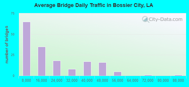
- 2,836,776Total average daily traffic
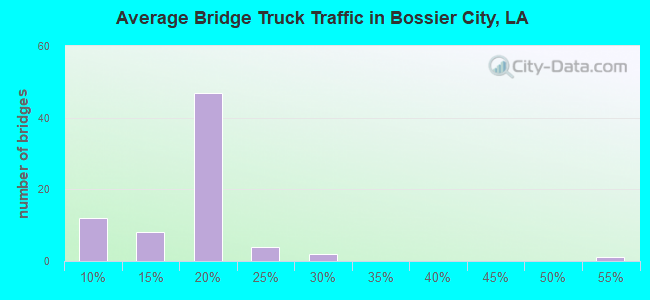
- 283,703Total average daily truck traffic
- National Bridge Inventory (NBI) Registered Bridges for Bossier City
- No street view available for this location
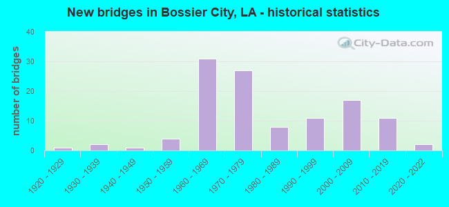
- New bridges - historical statistics
- 11920-1929
- 21930-1939
- 11940-1949
- 41950-1959
- 311960-1969
- 271970-1979
- 81980-1989
- 111990-1999
- 172000-2009
- 112010-2019
- 22020-2022
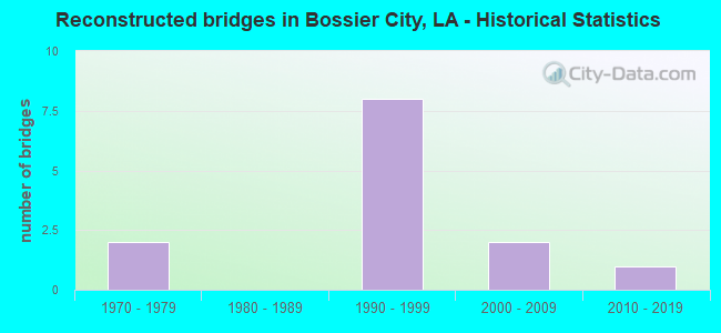
- Reconstructed bridges - Historical Statistics
- 21970-1979
- 01980-1989
- 81990-1999
- 22000-2009
- 12010-2019
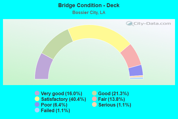
- Bridge Condition - Deck
- 16.0%Very good
- 21.3%Good
- 40.4%Satisfactory
- 13.8%Fair
- 6.4%Poor
- 1.1%Serious
- 1.1%Failed
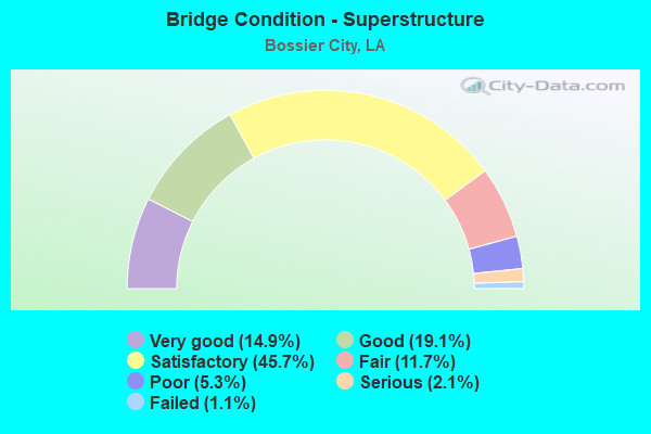
- Bridge Condition - Superstructure
- 14.9%Very good
- 19.1%Good
- 45.7%Satisfactory
- 11.7%Fair
- 5.3%Poor
- 2.1%Serious
- 1.1%Failed
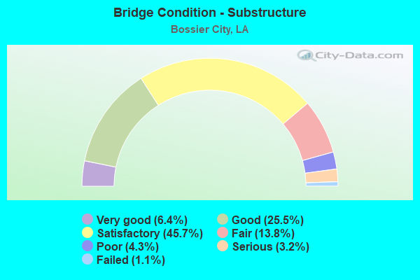
- Bridge Condition - Substructure
- 6.4%Very good
- 25.5%Good
- 45.7%Satisfactory
- 13.8%Fair
- 4.3%Poor
- 3.2%Serious
- 1.1%Failed
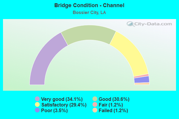
- Bridge Condition - Channel
- 34.1%Very good
- 30.6%Good
- 29.4%Satisfactory
- 1.2%Fair
- 3.5%Poor
- 1.2%Failed
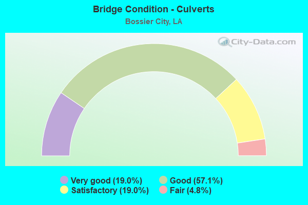
- Bridge Condition - Culverts
- 19.0%Very good
- 57.1%Good
- 19.0%Satisfactory
- 4.8%Fair
Find on map >> Show street view
Structure Number: 40804510201426, Location: US 71/ I-20 INTERCHANGE (Lat: 32.513661, Lng: -93.716069), Route carried "under" structure: Ramp Interstate 20, Structure Length: 0. m, Average Daily Traffic: 8,920 (year 2017), Features Intersected: BARKSDALE BLVD ON RAMP T, Facility Carried by Structure: BARKSDALE BLVD
Minimum Vertical Clearance: 4.69m (15.39ft), Kilometerpoint: 0.304, Lanes on structure: 2, Lanes under structure: 1, Length of Maximum Span: 0.0m
Find on map >> Show street view
Structure Number: 40804510201431, Location: US 71/I20 INTERCHANGE (Lat: 32.513169, Lng: -93.714981), Route carried "under" structure: Interstate 20, Structure Length: 0. m, Average Daily Traffic: 8,400 (year 2017), Features Intersected: US 71 ON RAMP TO I-20 WB, Facility Carried by Structure: US 71 ON RAMP
Minimum Vertical Clearance: 6.52m (21.39ft), Kilometerpoint: 23.907, Lanes on structure: 2, Lanes under structure: 2, Length of Maximum Span: 0.0m
Find on map >> Show street view
Structure Number: 40804510201431, Location: US 71/I-20 Interchange (Lat: 32.513200, Lng: -93.715550), Route carried "under" structure: Interstate 20, Structure Length: 0. m, Average Daily Traffic: 8,920 (year 2017), Features Intersected: BARKSDALE BLVD On ramp t
Minimum Vertical Clearance: 9.54m (31.30ft), Kilometerpoint: 0.235, Lanes on structure: 2, Lanes under structure: 1, Length of Maximum Span: 0.0m
Find on map >> Show street view
Structure Number: 40804510201431, Location: US 71/ I-20 INTERCHANGE (Lat: 32.513211, Lng: -93.714731), Route carried "under" structure: Ramp US 71, Structure Length: 0. m, Average Daily Traffic: 1,680 (year 2017), Features Intersected: US 71 OFF RAMP TO BARKSD
Minimum Vertical Clearance: 8.29m (27.20ft), Kilometerpoint: 0.071, Lanes on structure: 2, Lanes under structure: 1, Length of Maximum Span: 0.0m
Find on map >> Show street view
Structure Number: 40804510201431, Location: US71/ I-20 INTERCHANGE (Lat: 32.513269, Lng: -93.714439), Route carried "under" structure: Ramp US 71, Structure Length: 0. m, Average Daily Traffic: 1,680 (year 2017), Features Intersected: US 71 N OFF RAMP TO LA 3
Minimum Vertical Clearance: 6.10m (20.01ft), Kilometerpoint: 0.188, Lanes on structure: 2, Lanes under structure: 1, Length of Maximum Span: 0.0m
Find on map >> Show street view
Structure Number: 40804510201432, Location: US 71/ I-20 INTERCHANGE (Lat: 32.513350, Lng: -93.714631), Route carried "under" structure: Ramp US 71, Structure Length: 0. m, Average Daily Traffic: 1,680 (year 2017), Features Intersected: US 71 OFF RAMP TO LA 3
Minimum Vertical Clearance: 4.66m (15.29ft), Kilometerpoint: 0.204, Lanes on structure: 2, Lanes under structure: 1, Length of Maximum Span: 0.0m
Find on map >> Show street view
Structure Number: 40804510201432, Location: US 71/ I-20 INTERCHANGE (Lat: 32.513300, Lng: -93.714900), Route carried "under" structure: Ramp US 71, Structure Length: 0. m, Average Daily Traffic: 1,680 (year 2017), Features Intersected: US 71 OFF RAMP TO BARKSD
Minimum Vertical Clearance: 7.89m (25.89ft), Kilometerpoint: 0.090, Lanes on structure: 2, Lanes under structure: 1, Length of Maximum Span: 0.0m
Find on map >> Show street view
Structure Number: 40804510201432, Location: US 71/ I-20 Interchange (Lat: 32.513319, Lng: -93.715639), Route carried "under" structure: Ramp Interstate 20, Structure Length: 0. m, Average Daily Traffic: 8,920 (year 2017), Features Intersected: Barksdale Blvd on ramp t, Facility Carried by Structure: Barksdale Blvd
Minimum Vertical Clearance: 9.02m (29.59ft), Kilometerpoint: 0.253, Lanes on structure: 2, Lanes under structure: 1, Length of Maximum Span: 0.0m
Find on map >> Show street view
Structure Number: 40804510201432, Location: US 71/ I20 INTERCHANGE (Lat: 32.513261, Lng: -93.715219), Route carried "under" structure: US 71, Structure Length: 0. m, Average Daily Traffic: 8,400 (year 2017), Features Intersected: US 71 ON RAMP TO I-20 WB
Minimum Vertical Clearance: 5.06m (16.60ft), Kilometerpoint: 23.931, Lanes on structure: 2, Lanes under structure: 2, Length of Maximum Span: 0.0m
Find on map >> Show street view
Structure Number: 40804510201951, Location: 0.3 MI E OF BARKSDALE (Lat: 32.517961, Lng: -93.709089), Route carried "under" structure: State highway 72, Structure Length: 0. m, Average Daily Traffic: 43,740 (year 2015), Features Intersected: LA 72 WB under I-20 EB, Facility Carried by Structure: I-20 E
Minimum Vertical Clearance: 4.69m (15.39ft), Kilometerpoint: 2.385, Lanes on structure: 2, Lanes under structure: 2, Length of Maximum Span: 0.0m
Find on map >> Show street view
Structure Number: 40804510201951, Location: 0.3 MI W OF BARKSDALE (Lat: 32.517789, Lng: -93.709319), Route carried "under" structure: State highway 72, Structure Length: 0. m, Average Daily Traffic: 43,740 (year 2015), Features Intersected: LA 72 EB UNDER I-20 EB, Facility Carried by Structure: I-20 E
Minimum Vertical Clearance: 4.79m (15.72ft), Kilometerpoint: 0.002, Lanes on structure: 2, Lanes under structure: 2, Length of Maximum Span: 0.0m
Find on map >> Show street view
Structure Number: 40804510201952, Location: 0.3 MI E OF BARKSDALE BLV (Lat: 32.517911, Lng: -93.709281), Route carried "under" structure: Interstate 20, Structure Length: 0. m, Average Daily Traffic: 43,740 (year 2015), Features Intersected: I-20 WB OVER 72 W
Minimum Vertical Clearance: 4.94m (16.21ft), Kilometerpoint: 0.003, Lanes on structure: 2, Length of Maximum Span: 0.0m
Find on map >> Show street view
Structure Number: 40804510201952, Location: 0.3 MI E OF BARKSDALE BLV (Lat: 32.517750, Lng: -93.709531), Route carried "under" structure: Interstate 20, Structure Length: 0. m, Average Daily Traffic: 43,740 (year 2015), Features Intersected: I-20 W OVER 72 E
Minimum Vertical Clearance: 4.76m (15.62ft), Kilometerpoint: 1.580, Lanes on structure: 2, Length of Maximum Span: 0.0m
Find on map >> Show street view
Structure Number: 40804510202811, Location: 1.4 MI W OF INDUSTRIAL (Lat: 32.525381, Lng: -93.698900), Route carried "under" structure: Interstate 20, Structure Length: 0. m, Average Daily Traffic: 36,300 (year 2015), Features Intersected: I-20 E OVER 3105 N
Minimum Vertical Clearance: 4.69m (15.39ft), Kilometerpoint: 3.283, Lanes on structure: 2, Length of Maximum Span: 0.0m
Find on map >> Show street view
Structure Number: 40804510202811, Location: 1.4 MI W OF INDUSTRIAL (Lat: 32.525461, Lng: -93.699111), Route carried "under" structure: Interstate 20, Structure Length: 0. m, Average Daily Traffic: 36,300 (year 2015), Features Intersected: I-20 E OVER 3105 S
Minimum Vertical Clearance: 4.69m (15.39ft), Kilometerpoint: 6.692, Lanes on structure: 2, Length of Maximum Span: 0.0m
Find on map >> Show street view
Structure Number: 40804510202812, Location: 1.4 MI W OF INDUSTRIAL (Lat: 32.525619, Lng: -93.699111), Route carried "under" structure: Interstate 20, Structure Length: 0. m, Average Daily Traffic: 36,300 (year 2015), Features Intersected: I-20 W OVER 3105 N
Minimum Vertical Clearance: 4.91m (16.11ft), Kilometerpoint: 3.317, Lanes on structure: 2, Length of Maximum Span: 0.0m
Find on map >> Show street view
Structure Number: 40804510202812, Location: 1.4 MI W OF INDUSTRIAL (Lat: 32.525681, Lng: -93.699311), Route carried "under" structure: Interstate 20, Structure Length: 0. m, Average Daily Traffic: 36,300 (year 2015), Features Intersected: I-20 W OVER 3105 S
Minimum Vertical Clearance: 4.88m (16.01ft), Kilometerpoint: 6.661, Lanes on structure: 2, Length of Maximum Span: 0.0m
Find on map >> Show street view
Structure Number: 40804510203311, Location: 0.15 MI S OF US 80 (Lat: 32.525919, Lng: -93.690689), Route carried "under" structure: State highway 72, Structure Length: 0. m, Average Daily Traffic: 11,800 (year 2017), Features Intersected: LA 72 under I-20 EB
Minimum Vertical Clearance: 5.03m (16.50ft), Kilometerpoint: 2.134, Lanes on structure: 2, Lanes under structure: 2, Length of Maximum Span: 0.0m
Find on map >> Show street view
Structure Number: 40804510203312, Location: 0.12 MI S OF US 80 (Lat: 32.526289, Lng: -93.690650), Route carried "under" structure: State highway 72, Structure Length: 0. m, Average Daily Traffic: 11,800 (year 2017), Features Intersected: LA 72 UNDER I-20 WB
Minimum Vertical Clearance: 5.58m (18.31ft), Kilometerpoint: 2.174, Lanes on structure: 2, Lanes under structure: 2, Length of Maximum Span: 0.0m
Find on map >> Show street view
Structure Number: 40804510204231, Location: 0.34 MI S OF US 80 (Lat: 32.528331, Lng: -93.674261), Route carried "under" structure: State highway 7822, Structure Length: 0. m, Average Daily Traffic: 6,400 (year 2017), Features Intersected: LA 782-2 UNDER I-20 EB, Facility Carried by Structure: LA 782-2
Minimum Vertical Clearance: 4.82m (15.81ft), Kilometerpoint: 1.791, Lanes on structure: 2, Lanes under structure: 2, Length of Maximum Span: 0.0m
Find on map >> Show street view
Structure Number: 40804510204232, Location: 0.31 MI S OF US 80 (Lat: 32.528731, Lng: -93.674031), Route carried "under" structure: State highway 7822, Structure Length: 0. m, Average Daily Traffic: 6,400 (year 2017), Features Intersected: LA 782-2 UNDER I-20 WB, Facility Carried by Structure: LA 782-2
Minimum Vertical Clearance: 4.76m (15.62ft), Kilometerpoint: 1.839, Lanes on structure: 2, Lanes under structure: 2, Length of Maximum Span: 0.0m
Find on map >> Show street view
Structure Number: 40804513102791, Location: .9 MILES WEST OF LA 3105 (Lat: 32.557550, Lng: -93.726289), Route carried "under" structure: Interstate 220, Structure Length: 0. m, Average Daily Traffic: 20,940 (year 2015), Features Intersected: 220 EAST OVER LA 3 NORTH
Minimum Vertical Clearance: 5.00m (16.40ft), Kilometerpoint: 4.770, Lanes on structure: 2, Length of Maximum Span: 0.0m
Find on map >> Show street view
Structure Number: 40804513102791, Location: .9 MILES WEST OF LA 3105 (Lat: 32.557611, Lng: -93.726511), Route carried "under" structure: Interstate 220, Structure Length: 0. m, Average Daily Traffic: 20,941 (year 2015), Features Intersected: 220 EAST OVER LA 3 SOUTH
Minimum Vertical Clearance: 5.21m (17.09ft), Kilometerpoint: 15.937, Lanes on structure: 2, Length of Maximum Span: 0.0m
Find on map >> Show street view
Structure Number: 40804513102792, Location: .9 MILES WEST OF LA 3105 (Lat: 32.557869, Lng: -93.726569), Route carried "under" structure: Interstate 220, Structure Length: 0. m, Average Daily Traffic: 20,940 (year 2015), Features Intersected: 220 WEST OVER LA 3 SOUTH
Minimum Vertical Clearance: 5.36m (17.59ft), Kilometerpoint: 15.907, Lanes on structure: 2, Length of Maximum Span: 0.0m
Find on map >> Show street view
Structure Number: 40804513102792, Location: .9 MILES WEST OF LA 3105 (Lat: 32.557839, Lng: -93.726381), Route carried "under" structure: Interstate 220, Structure Length: 0. m, Average Daily Traffic: 20,940 (year 2015), Features Intersected: 220 WEST OVER LA 3 NORTH
Minimum Vertical Clearance: 5.18m (16.99ft), Kilometerpoint: 4.802, Lanes on structure: 2, Length of Maximum Span: 0.0m
Find on map >> Show street view
Structure Number: 40804513103741, Location: .9 MILES EAST OF LA 3 (Lat: 32.556850, Lng: -93.710400), Route carried "under" structure: Interstate 220, Structure Length: 0. m, Average Daily Traffic: 20,940 (year 2015), Features Intersected: 220 EAST OVER 3105 NORTH
Minimum Vertical Clearance: 5.30m (17.39ft), Kilometerpoint: 7.057, Lanes on structure: 2, Length of Maximum Span: 0.0m
Find on map >> Show street view
Structure Number: 40804513103741, Location: .9 MILES EAST OF LA 3 (Lat: 32.556861, Lng: -93.710561), Route carried "under" structure: Interstate 220, Structure Length: 0. m, Average Daily Traffic: 20,940 (year 2015), Features Intersected: 220 EAST OVER 3105 SOUTH
Minimum Vertical Clearance: 5.15m (16.90ft), Kilometerpoint: 2.935, Lanes on structure: 2, Length of Maximum Span: 0.0m
Find on map >> Show street view
Structure Number: 40804513103742, Location: .9 MILES EAST OF LA 3 (Lat: 32.557111, Lng: -93.710419), Route carried "under" structure: Interstate 220, Structure Length: 0. m, Average Daily Traffic: 20,940 (year 2015), Features Intersected: 220 WEST OVER 3105 NORTH
Minimum Vertical Clearance: 5.15m (16.90ft), Kilometerpoint: 7.086, Lanes on structure: 2, Length of Maximum Span: 0.0m
Find on map >> Show street view
Structure Number: 40804513103742, Location: .9 MILES EAST OF LA 3 (Lat: 32.557111, Lng: -93.710611), Route carried "under" structure: Interstate 220, Structure Length: 0. m, Average Daily Traffic: 20,940 (year 2015), Features Intersected: 220 WEST OVER 3105 SOUTH
Minimum Vertical Clearance: 5.12m (16.80ft), Kilometerpoint: 2.906, Lanes on structure: 2, Length of Maximum Span: 0.0m
Find on map >> Show street view
Structure Number: 40804513106531, Location: 1.2 MILES EAST OF SWAN L (Lat: 32.557600, Lng: -93.657239), Route carried "under" structure: Interstate 220, Structure Length: 0. m, Average Daily Traffic: 1,818 (year 2015), Features Intersected: SHED RD OVER 220 EAST
Minimum Vertical Clearance: 5.09m (16.70ft), Kilometerpoint: 11.072, Lanes on structure: 2, Length of Maximum Span: 0.0m
Find on map >> Show street view
Structure Number: 40804513106531, Location: 1.2 MILES EAST OF SWAN L (Lat: 32.558281, Lng: -93.656481), Route carried "under" structure: Interstate 49, Structure Length: 0. m, Average Daily Traffic: 1,818 (year 2015), Features Intersected: SHED RD OVER 220 WEST, Facility Carried by Structure: Alternate US
Minimum Vertical Clearance: 5.24m (17.19ft), Kilometerpoint: 4.490, Lanes on structure: 2, Length of Maximum Span: 0.0m
Find on map >> Show street view
Structure Number: 40804513106541, Location: 1.2 MILES EAST OF SWAN (Lat: 32.557639, Lng: -93.656739), Route carried "under" structure: Interstate 220, Structure Length: 0. m, Average Daily Traffic: 1,818 (year 2015), Features Intersected: SHED RD OVER 220 EAST
Minimum Vertical Clearance: 5.15m (16.90ft), Kilometerpoint: 11.121, Lanes on structure: 2, Length of Maximum Span: 0.0m
Find on map >> Show street view
Structure Number: 40804513106541, Location: 1.2 MILES EAST OF SWAN (Lat: 32.558311, Lng: -93.655961), Route carried "under" structure: Interstate 220, Structure Length: 0. m, Average Daily Traffic: 1,818 (year 2015), Features Intersected: SHED RD OVER 220 WEST
Minimum Vertical Clearance: 5.03m (16.50ft), Kilometerpoint: 4.442, Lanes on structure: 2, Length of Maximum Span: 0.0m
Find on map >> Show street view
Structure Number: 40804513108721, Location: .5 MILES NORTH OF I20 (Lat: 32.547381, Lng: -93.633239), Route carried "under" structure: Interstate 220, Structure Length: 0. m, Average Daily Traffic: 17,400 (year 2015), Features Intersected: 220 EAST OVER 80 WEST
Minimum Vertical Clearance: 5.15m (16.90ft), Kilometerpoint: 18.110, Lanes on structure: 2, Length of Maximum Span: 0.0m
Find on map >> Show street view
Structure Number: 40804513108721, Location: .5 MILES NORTH OF I20 (Lat: 32.547200, Lng: -93.633161), Route carried "under" structure: Interstate 220, Structure Length: 0. m, Average Daily Traffic: 17,400 (year 2015), Features Intersected: 220 EAST OVER 80 EAST
Minimum Vertical Clearance: 4.97m (16.31ft), Kilometerpoint: 11.626, Lanes on structure: 2, Length of Maximum Span: 0.0m
Find on map >> Show street view
Structure Number: 40804513108722, Location: .5 MILES NORTH OF I20 (Lat: 32.547561, Lng: -93.632719), Route carried "under" structure: Interstate 220, Structure Length: 0. m, Average Daily Traffic: 18,180 (year 2015), Features Intersected: 220 WEST OVER 80 EAST
Minimum Vertical Clearance: 4.91m (16.11ft), Kilometerpoint: 11.682, Lanes on structure: 2, Length of Maximum Span: 0.0m
Find on map >> Show street view
Structure Number: 40804513108722, Location: .5 MILES NORTH OF I20 (Lat: 32.547731, Lng: -93.632789), Route carried "under" structure: Interstate 220, Structure Length: 0. m, Average Daily Traffic: 18,180 (year 2015), Features Intersected: 220 WEST OVER 80 WEST
Minimum Vertical Clearance: 4.88m (16.01ft), Kilometerpoint: 18.054, Lanes on structure: 2, Length of Maximum Span: 0.0m
Find on map >> Show street view
Structure Number: 40804513109757, Location: I20 WB under ramp (Lat: 32.539389, Lng: -93.631781), Route carried "under" structure: Interstate 20, Structure Length: 0. m, Average Daily Traffic: 55,200 (year 2014), Features Intersected: I20 WB under I220 Ramp t
Minimum Vertical Clearance: 5.43m (17.81ft), Kilometerpoint: 18.792, Lanes on structure: 2, Length of Maximum Span: 0.0m
Find on map >> Show street view
Structure Number: 40804513109757, Location: I20 East bound under ramp (Lat: 32.539161, Lng: -93.631689), Route carried "under" structure: Interstate 20, Structure Length: 0. m, Average Daily Traffic: 55,200 (year 2014), Features Intersected: I20 EB under Ramp I220
Minimum Vertical Clearance: 5.00m (16.40ft), Kilometerpoint: 11.087, Lanes on structure: 2, Length of Maximum Span: 0.0m
Find on map >> Show street view
Structure Number: 40804513109786, Location: RAMP I-220 E UNDER RAMP (Lat: 32.539500, Lng: -93.628189), Route carried "under" structure: Ramp Interstate 20, Structure Length: 0. m, Average Daily Traffic: 55,200 (year 2014), Features Intersected: RAMP I-220 E TO I-20 E U
Minimum Vertical Clearance: 7.04m (23.10ft), Kilometerpoint: 1.033, Lanes on structure: 2, Length of Maximum Span: 0.0m
Find on map >> Show street view
Structure Number: 40804513109786, Location: I-20 EB UNDER RAMP (Lat: 32.540061, Lng: -93.628011), Route carried "under" structure: Interstate 20, Structure Length: 0. m, Average Daily Traffic: 55,200 (year 2014), Features Intersected: I-20 EB & RAMP C I-20 E
Minimum Vertical Clearance: 7.62m (25.00ft), Kilometerpoint: 11.447, Lanes on structure: 2, Length of Maximum Span: 0.0m
Find on map >> Show street view
Structure Number: 40804513109786, Location: I-20 E RAMP TO I-220 (Lat: 32.540369, Lng: -93.627831), Route carried "under" structure: Interstate 20, Structure Length: 0. m, Average Daily Traffic: 55,200 (year 2014), Features Intersected: RAMP I-20 W TO I-220 E
Minimum Vertical Clearance: 6.04m (19.82ft), Kilometerpoint: 18.406, Lanes on structure: 2, Length of Maximum Span: 0.0m