Bridge Statistics for East St. Louis, Illinois (IL)
Condition, Traffic, Stress, Structural Evaluation, Project Costs
- National Bridge Inventory (NBI) Statistics
- 182Number of bridges
- 6,342ft / 1,933mTotal length
- $671,536,000Total costs
- 3,946,450Total average daily traffic
- 478,774Total average daily truck traffic
- National Bridge Inventory (NBI) Registered Bridges for East St. Louis
- No street view available for this location
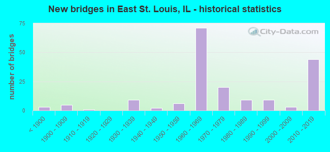
- New bridges - historical statistics
- 3Before 1900
- 51900-1909
- 11910-1919
- 91930-1939
- 21940-1949
- 61950-1959
- 711960-1969
- 201970-1979
- 91980-1989
- 91990-1999
- 32000-2009
- 442010-2019
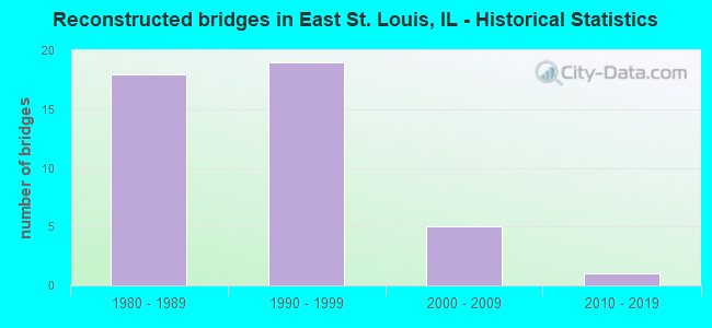
- Reconstructed bridges - Historical Statistics
- 181980-1989
- 191990-1999
- 52000-2009
- 12010-2019
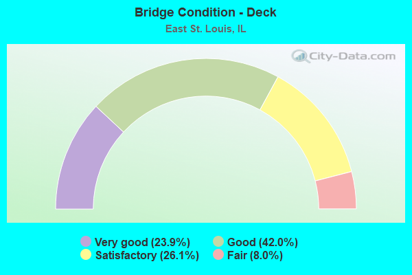
- Bridge Condition - Deck
- 23.9%Very good
- 42.0%Good
- 26.1%Satisfactory
- 8.0%Fair
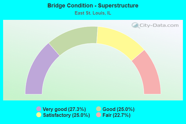
- Bridge Condition - Superstructure
- 27.3%Very good
- 25.0%Good
- 25.0%Satisfactory
- 22.7%Fair
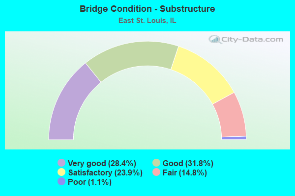
- Bridge Condition - Substructure
- 28.4%Very good
- 31.8%Good
- 23.9%Satisfactory
- 14.8%Fair
- 1.1%Poor
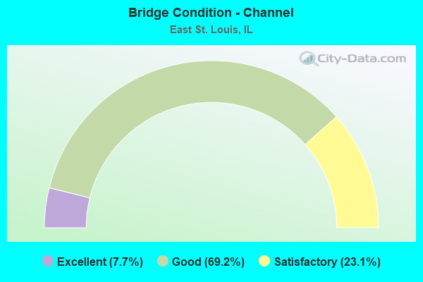
- Bridge Condition - Channel
- 7.7%Excellent
- 69.2%Good
- 23.1%Satisfactory
Find on map >> Show street view
Structure Number: 820378, Location: E ST L AT BOWMAN YD (Lat: 38.634197, Lng: -90.140436), Route carried "on" structure: Other road , Year Built: 2011, Status: Open, Structure Length: 9.20m (30.18ft), Average Daily Traffic: 1,250 (year 2021), Truck Traffic: 13%, Average Future Daily Traffic: 1,151 (year 2032), Design Load: HS 25 or greater, Features Intersected: I-55/70, Facility Carried by Structure: EXCHANGE AVENUE
Minimum Vertical Clearance: 30+ m (98+ ft), Kilometerpoint: 3.846, Lanes on structure: 2, Lanes under structure: 10, Owner: State Highway Agency, Approaching Roadway Width: 9.1m (29.9ft), Material/Design: Steel continuous, Design/Construction: Stringer/Multi-beam, Number Of Spans In Main Unit: 2, Length of Maximum Span: 49.7m (163.1ft), Curb or Sidewalk Widths: Left: 3.4m (11.2ft), Right: 0.0m, Curb-To-Curb Width: 9.1m (29.9ft), Out-to-Out Width: 13.3m (43.6ft)
Condition: Deck: Very good, Superstructure: Very good, Substructure: Very good, Operating Rating: 73.9 metric tons, Method Used To Determine Operating Rating: Load Factor (LF) rating reported by rating factor (RF) method using MS18 loading, Inventory Rating: 44.4 metric tons, Method Used To Determine Inventory Rating: Load Factor (LF) rating reported by rating factor (RF) method using MS18 loading, Structural Evaluation: Equal to present desirable criteria, Deck Geometry: Somewhat better than minimum adequacy, Approach Roadway Alignment: Equal to present desirable criteria, Designated Inspection Frequency: Every 24 months, Inspection Date: May 2021, Deck Structure Type: Concrete Cast-file-Place, Wearing Surface/Protective System: Deck Protection: Epoxy Coated Reinforcing
Find on map >> Show street view
Structure Number: 820385, Location: UNDER MLK APPR BRDGE (Lat: 38.629519, Lng: -90.164483), Route carried "on" structure: Other road , Year Built: 2015, Status: Open, Structure Length: 1.95m (6.40ft), Average Daily Traffic: 1,800 (year 2018), Truck Traffic: 14%, Average Future Daily Traffic: 8,000 (year 2024), Design Load: HS 25 or greater, Features Intersected: LAND BRIDGE, Facility Carried by Structure: NB RELOCATED IL 3
Minimum Vertical Clearance: 5.72m (18.77ft), Kilometerpoint: 3.911, Lanes on structure: 2, Base Highway Network: Yes, Owner: State Highway Agency, Approaching Roadway Width: 11.3m (37.1ft), Skew: 1 degrees, Material/Design: Steel, Design/Construction: Stringer/Multi-beam, Number Of Spans In Main Unit: 1, Length of Maximum Span: 18.7m (61.4ft), Curb-To-Curb Width: 11.3m (37.1ft), Out-to-Out Width: 12.3m (40.4ft)
Condition: Deck: Very good, Superstructure: Very good, Substructure: Very good, Operating Rating: 85.5 metric tons, Method Used To Determine Operating Rating: Load and Resistance Factor Rating (LRFR) rating reported by rating factor(RF) method using HL-93 loadings, Inventory Rating: 65.8 metric tons, Method Used To Determine Inventory Rating: Load and Resistance Factor Rating (LRFR) rating reported by rating factor(RF) method using HL-93 loadings, Structural Evaluation: Equal to present desirable criteria, Deck Geometry: Equal to present minimum criteria, Approach Roadway Alignment: Equal to present desirable criteria, Designated Inspection Frequency: Every 48 months, Inspection Date: September 2021, Deck Structure Type: Concrete Cast-file-Place, Wearing Surface/Protective System: Deck Protection: Epoxy Coated Reinforcing
Find on map >> Show street view
Structure Number: 820386, Location: UNDER MLK APPR BRDGE (Lat: 38.629817, Lng: -90.164444), Route carried "on" structure: Other road , Year Built: 2015, Status: Open, Structure Length: 1.95m (6.40ft), Average Daily Traffic: 1,800 (year 2018), Truck Traffic: 14%, Average Future Daily Traffic: 8,000 (year 2024), Design Load: HS 25 or greater, Features Intersected: LAND BRIDGE, Facility Carried by Structure: SB RELOCATED IL 3
Minimum Vertical Clearance: 5.51m (18.08ft), Kilometerpoint: 3.878, Lanes on structure: 2, Base Highway Network: Yes, Owner: State Highway Agency, Approaching Roadway Width: 11.6m (38.1ft), Skew: 1 degrees, Material/Design: Steel, Design/Construction: Stringer/Multi-beam, Number Of Spans In Main Unit: 1, Length of Maximum Span: 18.7m (61.4ft), Curb-To-Curb Width: 11.6m (38.1ft), Out-to-Out Width: 12.6m (41.3ft)
Condition: Deck: Very good, Superstructure: Very good, Substructure: Very good, Operating Rating: 83.6 metric tons, Method Used To Determine Operating Rating: Load and Resistance Factor Rating (LRFR) rating reported by rating factor(RF) method using HL-93 loadings, Inventory Rating: 64.2 metric tons, Method Used To Determine Inventory Rating: Load and Resistance Factor Rating (LRFR) rating reported by rating factor(RF) method using HL-93 loadings, Structural Evaluation: Equal to present desirable criteria, Deck Geometry: Better than present minimum criteria, Approach Roadway Alignment: Equal to present desirable criteria, Designated Inspection Frequency: Every 48 months, Inspection Date: September 2021, Deck Structure Type: Concrete Cast-file-Place, Wearing Surface/Protective System: Deck Protection: Epoxy Coated Reinforcing
Find on map >> Show street view
Structure Number: 820399, Location: AT FRENCH VILLAGE (Lat: 38.598150, Lng: -90.053444), Route carried "on" structure: State highway 157, Year Built: 2017, Status: Open, Structure Length: 14.94m (49.02ft), Average Daily Traffic: 4,850 (year 2021), Truck Traffic: 9%, Average Future Daily Traffic: 10,303 (year 2032), Design Load: HS 25 or greater, Features Intersected: ST CL AVE,METRO,CRK
Minimum Vertical Clearance: 30+ m (98+ ft), Kilometerpoint: 15.707, Lanes on structure: 4, Lanes under structure: 4, Base Highway Network: Yes, Owner: State Highway Agency, Approaching Roadway Width: 16.2m (53.1ft), Skew: 31 degrees, Material/Design: Steel continuous, Design/Construction: Stringer/Multi-beam, Number Of Spans In Main Unit: 5, Length of Maximum Span: 34.1m (111.9ft), Curb or Sidewalk Widths: Left: 3.0m (9.8ft), Right: 0.0m, Curb-To-Curb Width: 16.2m (53.1ft), Out-to-Out Width: 21.4m (70.2ft)
Condition: Deck: Very good, Superstructure: Very good, Substructure: Very good, Channel: Excellent, Operating Rating: 57.0 metric tons, Method Used To Determine Operating Rating: Load and Resistance Factor Rating (LRFR) rating reported by rating factor(RF) method using HL-93 loadings, Inventory Rating: 44.1 metric tons, Method Used To Determine Inventory Rating: Load and Resistance Factor Rating (LRFR) rating reported by rating factor(RF) method using HL-93 loadings, Structural Evaluation: Equal to present desirable criteria, Deck Geometry: Meets minimum limits, Waterway Adequacy: Equal to present desirable criteria, Approach Roadway Alignment: Equal to present desirable criteria, Designated Inspection Frequency: Every 24 months, Inspection Date: June 2021, Deck Structure Type: Concrete Cast-file-Place, Wearing Surface/Protective System: Deck Protection: Epoxy Coated Reinforcing
Find on map >> Show street view
Structure Number: 823083, Location: 100'S ST. CLAIR AVE (Lat: 38.603069, Lng: -90.064517), Route carried "on" structure: Other road , Year Built: 1991, Status: Open, Structure Length: 2.16m (7.09ft), Average Daily Traffic: 2,850 (year 2018), Truck Traffic: 5%, Average Future Daily Traffic: 3,452 (year 2032), Design Load: HS 20, Features Intersected: HARDIN DITCH, Facility Carried by Structure: FAU 9241
Minimum Vertical Clearance: 30+ m (98+ ft), Kilometerpoint: 0.064, Lanes on structure: 2, Owner: County Highway Agency, Approaching Roadway Width: 4.9m (16.1ft), Material/Design: Prestressed concrete, Design/Construction: Box Beam or Girders - Multiple, Number Of Spans In Main Unit: 1, Length of Maximum Span: 20.8m (68.2ft), Curb-To-Curb Width: 9.8m (32.2ft), Out-to-Out Width: 9.8m (32.2ft)
Condition: Deck: Satisfactory, Superstructure: Satisfactory, Substructure: Very good, Channel: Good, Operating Rating: 44.4 metric tons, Method Used To Determine Operating Rating: Assigned rating based on Load Factor Design (LFD) reported by rating factor (RF) using MS18 loading, Inventory Rating: 32.4 metric tons, Method Used To Determine Inventory Rating: Assigned rating based on Load Factor Design (LFD) reported by rating factor (RF) using MS18 loading, Structural Evaluation: Equal to present minimum criteria, Deck Geometry: Meets minimum limits, Waterway Adequacy: Equal to present desirable criteria, Approach Roadway Alignment: Equal to present desirable criteria, Designated Inspection Frequency: Every 24 months, Inspection Date: March 2020, Deck Structure Type: Concrete Precast Panels, Wearing Surface/Protective System: Wearing Surface: Bituminous, Membrane: Built-up
Find on map >> Show street view
Structure Number: 826001, Location: East St. Louis (Lat: 38.630933, Lng: -90.178294), Route carried "on" structure: Other road , Year Built: 1950, Year Reconstructed: 1988, Status: Posted for load, Structure Length: 122.29m (401.21ft), Average Daily Traffic: 9,650 (year 2017), Truck Traffic: 2%, Average Future Daily Traffic: 30,334 (year 2032), Design Load: HS 20, Features Intersected: Mississippi Rv/RR/MS-600, Facility Carried by Structure: FAP-799
Minimum Vertical Clearance: 6.10m (20.01ft), Kilometerpoint: 0.016, Lanes on structure: 3, Lanes under structure: 4, Base Highway Network: Yes, Owner: State Highway Agency, Approaching Roadway Width: 11.6m (38.1ft), Navigation Control: Yes ( Vertical Clearance: 16.8m (55.1ft), Horizontal Clearance: 286.5m (940.0ft)), Material/Design: Steel continuous, Design/Construction: Truss - Thru, Number Of Spans In Main Unit: 3, Number Of Approach Spans: 31, Length of Maximum Span: 293.5m (962.9ft), Curb-To-Curb Width: 11.6m (38.1ft), Out-to-Out Width: 13.3m (43.6ft)
Condition: Deck: Satisfactory, Superstructure: Fair, Substructure: Poor, Channel: Good, Operating Rating: 30.8 metric tons, Method Used To Determine Operating Rating: Load Factor (LF) rating reported by rating factor (RF) method using MS18 loading, Inventory Rating: 18.8 metric tons, Method Used To Determine Inventory Rating: Load Factor (LF) rating reported by rating factor (RF) method using MS18 loading, Structural Evaluation: Meets minimum limits, Deck Geometry: High priority of replacement, Underclear: Superior to present desirable criteria, Waterway Adequacy: Superior to present desirable criteria, Approach Roadway Alignment: Equal to present desirable criteria, Length Of Structure Improvement: 122.29m (401.21ft), Designated Inspection Frequency: Every 12 months, Critical Feature Inspection Frequency: Every 12 months, Underwater Inspection Frequency: Every 60 months, Inspection Date: September 2021, Critical Feature Inspection Date: September 2021, Underwater Inspection Date: September 2020, Bridge Improvement Cost: $11,900,000, Roadway Improvement Cost: $1,900,000, Total Project Cost: $13,800,000, Deck Structure Type: Concrete Cast-file-Place, Wearing Surface/Protective System: Deck Protection: Epoxy Coated Reinforcing
Find on map >> Show street view
Structure Number: 826006, Location: 0.1 Mi E 3rd ST EXIT (Lat: 38.629492, Lng: -90.156883), Route carried "on" structure: Other road , Year Built: 1961, Year Reconstructed: 1993, Status: Open, Structure Length: 1.74m (5.71ft), Average Daily Traffic: 5,400 (year 2020), Truck Traffic: 2%, Average Future Daily Traffic: 12,970 (year 2032), Design Load: HS 20, Features Intersected: RAMP TO WB MLK BR, Facility Carried by Structure: MLK BR APPR EB & W
Minimum Vertical Clearance: 30+ m (98+ ft), Kilometerpoint: 1.835, Lanes on structure: 2, Lanes under structure: 1, Base Highway Network: Yes, Owner: State Highway Agency, Approaching Roadway Width: 21.9m (71.9ft), Skew: 30 degrees, Material/Design: Steel, Design/Construction: Stringer/Multi-beam, Number Of Spans In Main Unit: 1, Length of Maximum Span: 16.7m (54.8ft), Curb-To-Curb Width: 25.1m (82.3ft), Out-to-Out Width: 26.1m (85.6ft)
Condition: Deck: Very good, Superstructure: Good, Substructure: Satisfactory, Operating Rating: 73.9 metric tons, Method Used To Determine Operating Rating: Load Factor (LF) rating reported by rating factor (RF) method using MS18 loading, Inventory Rating: 44.4 metric tons, Method Used To Determine Inventory Rating: Load Factor (LF) rating reported by rating factor (RF) method using MS18 loading, Structural Evaluation: Equal to present minimum criteria, Deck Geometry: Superior to present desirable criteria, Underclear: Meets minimum limits, Approach Roadway Alignment: Equal to present desirable criteria, Designated Inspection Frequency: Every 24 months, Inspection Date: May 2021, Deck Structure Type: Concrete Cast-file-Place, Wearing Surface/Protective System: Wearing Surface: Other
Find on map >> Show street view
Structure Number: 826007, Location: 0.06 N OF PARK DR (Lat: 38.638214, Lng: -90.114664), Route carried "on" structure: City street , Year Built: 1935, Status: Open, Structure Length: 1.68m (5.51ft), Average Daily Traffic: 25 (year 2018), Truck Traffic: 40%, Average Future Daily Traffic: 10 (year 2032), Features Intersected: SCHOENBERGER CREEK, Facility Carried by Structure: 32ND ST - E.ST LOU
Minimum Vertical Clearance: 30+ m (98+ ft), Kilometerpoint: 0.145, Lanes on structure: 2, Owner: City or Municipal Highway Agency, Approaching Roadway Width: 6.7m (22.0ft), Material/Design: Concrete continuous, Design/Construction: Tee Beam, Number Of Spans In Main Unit: 3, Length of Maximum Span: 11.3m (37.1ft), Curb or Sidewalk Widths: Left: 1.2m (3.9ft), Right: 1.2m (3.9ft), Curb-To-Curb Width: 6.7m (22.0ft), Out-to-Out Width: 9.7m (31.8ft)
Condition: Deck: Good, Superstructure: Good, Substructure: Satisfactory, Channel: Good, Operating Rating: 40.5 metric tons, Method Used To Determine Operating Rating: Field evaluation and documented engineering judgment, Inventory Rating: 24.3 metric tons, Method Used To Determine Inventory Rating: Field evaluation and documented engineering judgment, Structural Evaluation: Equal to present minimum criteria, Deck Geometry: Somewhat better than minimum adequacy, Waterway Adequacy: Better than present minimum criteria, Approach Roadway Alignment: Equal to present minimum criteria, Designated Inspection Frequency: Every 24 months, Inspection Date: July 2020, Deck Structure Type: Concrete Cast-file-Place
Find on map >> Show street view
Structure Number: 826008, Location: 0.01 (Lat: 38.638567, Lng: -90.112114), Route carried "on" structure: City street , Year Built: 1935, Status: Open, Structure Length: 1.68m (5.51ft), Average Daily Traffic: 50 (year 2018), Truck Traffic: 20%, Average Future Daily Traffic: 62 (year 2032), Features Intersected: SCHOENBERGER CREEK, Facility Carried by Structure: 36TH ST E ST LOUIS
Minimum Vertical Clearance: 30+ m (98+ ft), Kilometerpoint: 0.097, Lanes on structure: 2, Owner: City or Municipal Highway Agency, Approaching Roadway Width: 6.7m (22.0ft), Material/Design: Concrete continuous, Design/Construction: Tee Beam, Number Of Spans In Main Unit: 3, Length of Maximum Span: 11.3m (37.1ft), Curb or Sidewalk Widths: Left: 1.2m (3.9ft), Right: 1.2m (3.9ft), Curb-To-Curb Width: 6.7m (22.0ft), Out-to-Out Width: 9.7m (31.8ft)
Condition: Deck: Good, Superstructure: Good, Substructure: Satisfactory, Channel: Good, Operating Rating: 40.5 metric tons, Method Used To Determine Operating Rating: Field evaluation and documented engineering judgment, Inventory Rating: 24.3 metric tons, Method Used To Determine Inventory Rating: Field evaluation and documented engineering judgment, Structural Evaluation: Equal to present minimum criteria, Deck Geometry: Somewhat better than minimum adequacy, Waterway Adequacy: Better than present minimum criteria, Approach Roadway Alignment: Meets minimum limits, Designated Inspection Frequency: Every 24 months, Inspection Date: July 2020, Deck Structure Type: Concrete Cast-file-Place
Find on map >> Show street view
Structure Number: 826009, Location: 0.03 N OF PARK DR (Lat: 38.638992, Lng: -90.108692), Route carried "on" structure: City street , Year Built: 1935, Status: Open, Structure Length: 1.68m (5.51ft), Average Daily Traffic: 75 (year 2018), Truck Traffic: 13%, Average Future Daily Traffic: 166 (year 2032), Features Intersected: SCHOENBER GER CREEK, Facility Carried by Structure: 40TH ST - E ST LOU
Minimum Vertical Clearance: 30+ m (98+ ft), Kilometerpoint: 0.113, Lanes on structure: 2, Owner: City or Municipal Highway Agency, Approaching Roadway Width: 6.7m (22.0ft), Material/Design: Concrete continuous, Design/Construction: Tee Beam, Number Of Spans In Main Unit: 3, Length of Maximum Span: 11.3m (37.1ft), Curb or Sidewalk Widths: Left: 1.2m (3.9ft), Right: 1.2m (3.9ft), Curb-To-Curb Width: 6.7m (22.0ft), Out-to-Out Width: 9.7m (31.8ft)
Condition: Deck: Good, Superstructure: Good, Substructure: Satisfactory, Channel: Good, Operating Rating: 40.5 metric tons, Method Used To Determine Operating Rating: Field evaluation and documented engineering judgment, Inventory Rating: 24.3 metric tons, Method Used To Determine Inventory Rating: Field evaluation and documented engineering judgment, Structural Evaluation: Equal to present minimum criteria, Deck Geometry: Somewhat better than minimum adequacy, Waterway Adequacy: Better than present minimum criteria, Approach Roadway Alignment: Meets minimum limits, Designated Inspection Frequency: Every 24 months, Inspection Date: July 2020, Deck Structure Type: Concrete Cast-file-Place
Find on map >> Show street view
Structure Number: 82601, Location: .15 E OF 40TH ST (Lat: 38.608758, Lng: -90.110389), Route carried "on" structure: Other road , Year Built: 1999, Status: Open, Structure Length: 5.02m (16.47ft), Average Daily Traffic: 5,500 (year 2021), Truck Traffic: 5%, Average Future Daily Traffic: 7,845 (year 2032), Design Load: HS 20, Features Intersected: ALTON/SOUTH RR, Facility Carried by Structure: STATE STREET
Minimum Vertical Clearance: 30+ m (98+ ft), Kilometerpoint: 3.975, Lanes on structure: 4, Base Highway Network: Yes, Owner: City or Municipal Highway Agency, Approaching Roadway Width: 15.6m (51.2ft), Material/Design: Steel continuous, Design/Construction: Stringer/Multi-beam, Number Of Spans In Main Unit: 3, Length of Maximum Span: 19.0m (62.3ft), Curb or Sidewalk Widths: Left: 1.5m (4.9ft), Right: 1.5m (4.9ft), Curb-To-Curb Width: 16.9m (55.4ft), Out-to-Out Width: 20.5m (67.3ft)
Condition: Deck: Very good, Superstructure: Very good, Substructure: Very good, Operating Rating: 44.1 metric tons, Method Used To Determine Operating Rating: Load Factor (LF) rating reported by rating factor (RF) method using MS18 loading, Inventory Rating: 32.4 metric tons, Method Used To Determine Inventory Rating: Load Factor (LF) rating reported by rating factor (RF) method using MS18 loading, Structural Evaluation: Equal to present desirable criteria, Deck Geometry: Somewhat better than minimum adequacy, Underclear: Equal to present desirable criteria, Approach Roadway Alignment: Equal to present desirable criteria, Designated Inspection Frequency: Every 48 months, Inspection Date: July 2020, Deck Structure Type: Concrete Cast-file-Place, Wearing Surface/Protective System: Deck Protection: Epoxy Coated Reinforcing
Find on map >> Show street view
Structure Number: 829929, Location: E ST LOUIS (Lat: 38.628914, Lng: -90.178683), Route carried "on" structure: Other road , Year Built: 1874, Year Reconstructed: 2003, Status: Open, Structure Length: 122.13m (400.69ft), Average Daily Traffic: 14,600 (year 2019), Truck Traffic: 1%, Average Future Daily Traffic: 2,700 (year 2038), Design Load: H 15, Features Intersected: MISS RIV/RR/MSS6000, Facility Carried by Structure: FAU 9187A & MET LI
Minimum Vertical Clearance: 30+ m (98+ ft), Kilometerpoint: 0.016, Lanes on structure: 4, Lanes under structure: 2, Base Highway Network: Yes, Owner: Private, Approaching Roadway Width: 12.5m (41.0ft), Navigation Control: Yes ( Vertical Clearance: 9.8m (32.2ft), Horizontal Clearance: 157.6m (517.1ft)), Material/Design: Steel, Number Of Spans In Main Unit: 4, Number Of Approach Spans: 41, Length of Maximum Span: 158.5m (520.0ft), Curb or Sidewalk Widths: Left: 1.8m (5.9ft), Right: 1.8m (5.9ft), Curb-To-Curb Width: 14.0m (45.9ft), Out-to-Out Width: 16.6m (54.5ft)
Condition: Deck: Satisfactory, Superstructure: Fair, Substructure: Fair, Channel: Satisfactory, Operating Rating: 89.1 metric tons, Method Used To Determine Operating Rating: Allowable Stress (AS) rating reported by rating factor (RF) method using MS18 loading, Inventory Rating: 89.1 metric tons, Method Used To Determine Inventory Rating: Allowable Stress (AS) rating reported by rating factor (RF) method using MS18 loading, Structural Evaluation: Somewhat better than minimum adequacy, Deck Geometry: High priority of replacement, Underclear: Superior to present desirable criteria, Waterway Adequacy: Equal to present desirable criteria, Approach Roadway Alignment: Equal to present minimum criteria, Length Of Structure Improvement: 111.28m (365.09ft), Designated Inspection Frequency: Every 24 months, Critical Feature Inspection Frequency: Every 24 months, Underwater Inspection Frequency: Every 60 months, Inspection Date: April 2020, Critical Feature Inspection Date: July 2020, Underwater Inspection Date: October 2019, Bridge Improvement Cost: $8,850,000, Roadway Improvement Cost: $885,000, Total Project Cost: $9,735,000, Deck Structure Type: Concrete Cast-file-Place, Wearing Surface/Protective System: Wearing Surface: Integral Concrete
Find on map >> Show street view
Structure Number: 820001, Location: ST CLAIR AVE E ST L (Lat: 38.634019, Lng: -90.147467), Route carried "under" structure: State highway 3, Year Built: 1960, Structure Length: 0. m, Average Daily Traffic: 4,250 (year 2021), Truck Traffic: 17%, Features Intersected: ST CLAIR AVE E ST L, Facility Carried by Structure: FAI 64 WB
Minimum Vertical Clearance: 4.65m (15.26ft), Kilometerpoint: 236.181, Lanes on structure: 2, Lanes under structure: 4, Material/Design: Steel continuous, Design/Construction: Stringer/Multi-beam, Length of Maximum Span: 28.7m (94.2ft)
Find on map >> Show street view
Structure Number: 820002, Location: W of Exchange Avenue (Lat: 38.633111, Lng: -90.144256), Route carried "under" structure: Interstate 55, Year Built: 1962, Structure Length: 0. m, Average Daily Traffic: 67,300 (year 2021), Truck Traffic: 16%, Features Intersected: EB 55 & Ramp to 64EB, Facility Carried by Structure: FAI 64 WB
Minimum Vertical Clearance: 4.75m (15.58ft), Kilometerpoint: 4.490, Lanes on structure: 2, Lanes under structure: 2, Material/Design: Steel, Design/Construction: Stringer/Multi-beam, Length of Maximum Span: 27.3m (89.6ft)
Find on map >> Show street view
Structure Number: 820003, Location: WEST OF EXCHANGE AVE (Lat: 38.633017, Lng: -90.144650), Route carried "under" structure: Interstate 55, Year Built: 1962, Structure Length: 0. m, Average Daily Traffic: 67,300 (year 2021), Truck Traffic: 16%, Features Intersected: I-55 EB mainline, Facility Carried by Structure: Ramp to EB I-64
Minimum Vertical Clearance: 4.93m (16.17ft), Kilometerpoint: 4.458, Lanes on structure: 1, Lanes under structure: 1, Material/Design: Steel, Design/Construction: Stringer/Multi-beam, Length of Maximum Span: 21.6m (70.9ft)
Find on map >> Show street view
Structure Number: 820006, Location: East of PSC (Lat: 38.618839, Lng: -90.166019), Route carried "under" structure: Other road , Year Built: 1965, Structure Length: 0. m, Average Daily Traffic: 300 (year 2018), Truck Traffic: 20%, Features Intersected: TRENDLY AVE. E ST L, Facility Carried by Structure: I-55/64; US 40 WB
Minimum Vertical Clearance: 4.60m (15.09ft), Kilometerpoint: 0.982, Lanes on structure: 2, Lanes under structure: 2, Material/Design: Steel continuous, Design/Construction: Stringer/Multi-beam, Length of Maximum Span: 24.4m (80.1ft)
Find on map >> Show street view
Structure Number: 820007, Location: 3RD BR E POP ST BR (Lat: 38.618736, Lng: -90.165897), Route carried "under" structure: Other road , Year Built: 1966, Structure Length: 0. m, Average Daily Traffic: 300 (year 2018), Truck Traffic: 20%, Features Intersected: TRENDLY AVE E ST L, Facility Carried by Structure: I-55/64; US 40 EB
Minimum Vertical Clearance: 5.54m (18.18ft), Kilometerpoint: 0.998, Lanes on structure: 2, Lanes under structure: 2, Material/Design: Steel continuous, Design/Construction: Stringer/Multi-beam, Length of Maximum Span: 24.5m (80.4ft)
Find on map >> Show street view
Structure Number: 820008, Location: WB OVER 4TH ST (Lat: 38.622703, Lng: -90.165275), Route carried "under" structure: City street , Year Built: 1965, Structure Length: 0. m, Average Daily Traffic: 150 (year 2018), Truck Traffic: 13%, Features Intersected: 4TH ST in E ST LOU, Facility Carried by Structure: I-55/64; US 40 WB
Minimum Vertical Clearance: 4.70m (15.42ft), Kilometerpoint: 0.338, Lanes on structure: 2, Lanes under structure: 2, Material/Design: Steel continuous, Design/Construction: Stringer/Multi-beam, Length of Maximum Span: 27.3m (89.6ft)
Find on map >> Show street view
Structure Number: 820009, Location: EB OVER 4TH ST (Lat: 38.622775, Lng: -90.165178), Route carried "under" structure: City street , Year Built: 1965, Structure Length: 0. m, Average Daily Traffic: 150 (year 2018), Truck Traffic: 13%, Features Intersected: 4TH ST in E ST LOU, Facility Carried by Structure: I-55/64; US 40 EB
Minimum Vertical Clearance: 30+ m (98+ ft), Kilometerpoint: 0.370, Lanes on structure: 4, Lanes under structure: 2, Material/Design: Steel continuous, Design/Construction: Stringer/Multi-beam, Length of Maximum Span: 28.8m (94.5ft)
Find on map >> Show street view
Structure Number: 82001, Location: E ST LOUIS (Lat: 38.624611, Lng: -90.164542), Route carried "under" structure: State highway 15, Year Built: 1965, Structure Length: 0. m, Average Daily Traffic: 2,950 (year 2021), Truck Traffic: 7%, Features Intersected: Broadway & METROLINK, Facility Carried by Structure: I-55/64; US 40 WB
Minimum Vertical Clearance: 7.34m (24.08ft), Kilometerpoint: 0.064, Lanes on structure: 3, Lanes under structure: 2, Material/Design: Steel continuous, Design/Construction: Stringer/Multi-beam, Length of Maximum Span: 38.7m (127.0ft)
Find on map >> Show street view
Structure Number: 82001, Location: E ST LOUIS (Lat: 38.626936, Lng: -90.164061), Route carried "under" structure: Other road , Year Built: 1965, Structure Length: 0. m, Average Daily Traffic: 9,600 (year 2018), Truck Traffic: 4%, Features Intersected: Broadway & METROLINK, Facility Carried by Structure: I-55/64; US 40 WB
Minimum Vertical Clearance: 4.70m (15.42ft), Kilometerpoint: 1.304, Lanes on structure: 3, Lanes under structure: 2, Material/Design: Steel continuous, Design/Construction: Stringer/Multi-beam, Length of Maximum Span: 38.7m (127.0ft)
Find on map >> Show street view
Structure Number: 820011, Location: E ST LOUIS (Lat: 38.624675, Lng: -90.164447), Route carried "under" structure: State highway 15, Year Built: 1965, Structure Length: 0. m, Average Daily Traffic: 2,950 (year 2021), Truck Traffic: 7%, Features Intersected: BROADWAY & METROLINK, Facility Carried by Structure: I-55/64; US 40 EB
Minimum Vertical Clearance: 4.47m (14.67ft), Kilometerpoint: 0.113, Lanes on structure: 3, Lanes under structure: 2, Material/Design: Steel continuous, Design/Construction: Stringer/Multi-beam, Length of Maximum Span: 39.0m (128.0ft)
Find on map >> Show street view
Structure Number: 820011, Location: E ST LOUIS (Lat: 38.626675, Lng: -90.163756), Route carried "under" structure: Other road , Year Built: 1965, Structure Length: 0. m, Average Daily Traffic: 9,600 (year 2018), Truck Traffic: 4%, Features Intersected: BROADWAY & METROLINK, Facility Carried by Structure: I-55/64; US 40 EB
Minimum Vertical Clearance: 4.47m (14.67ft), Kilometerpoint: 1.336, Lanes on structure: 3, Lanes under structure: 2, Material/Design: Steel continuous, Design/Construction: Stringer/Multi-beam, Length of Maximum Span: 39.0m (128.0ft)
Find on map >> Show street view
Structure Number: 820012, Location: 1/2 mi W 3rd St Exit (Lat: 38.628114, Lng: -90.161214), Route carried "under" structure: Other road , Year Built: 1965, Structure Length: 0. m, Average Daily Traffic: 10 (year 2018), Truck Traffic: 30%, Features Intersected: Missouri Avenue, Facility Carried by Structure: I-55/64; US 40 EB
Minimum Vertical Clearance: 4.62m (15.16ft), Kilometerpoint: 1.255, Lanes on structure: 3, Lanes under structure: 2, Material/Design: Steel continuous, Design/Construction: Stringer/Multi-beam, Length of Maximum Span: 20.5m (67.3ft)
Find on map >> Show street view
Structure Number: 820013, Location: E ST L - 3rd ST EXIT (Lat: 38.628667, Lng: -90.159647), Route carried "under" structure: Other road , Year Built: 1961, Structure Length: 0. m, Average Daily Traffic: 3,900 (year 2018), Truck Traffic: 9%, Features Intersected: 3RD ST EXIT to EStL, Facility Carried by Structure: EB 55/MLK EB&WB AP
Minimum Vertical Clearance: 4.45m (14.60ft), Kilometerpoint: 0.129, Lanes on structure: 7, Lanes under structure: 1, Material/Design: Steel, Design/Construction: Stringer/Multi-beam, Length of Maximum Span: 11.3m (37.1ft)
Find on map >> Show street view
Structure Number: 820014, Location: E ST LOUIS (Lat: 38.629714, Lng: -90.156939), Route carried "under" structure: Other road , Year Built: 1961, Structure Length: 0. m, Average Daily Traffic: 800 (year 2020), Features Intersected: RAMPS TO/FROM MLK DR, Facility Carried by Structure: 3RD ST TO EB I-55/
Minimum Vertical Clearance: 4.65m (15.26ft), Kilometerpoint: 0.193, Lanes on structure: 2, Lanes under structure: 2, Material/Design: Steel, Design/Construction: Stringer/Multi-beam, Length of Maximum Span: 22.4m (73.5ft)
Find on map >> Show street view
Structure Number: 820015, Location: W of ESL Tri-level (Lat: 38.634108, Lng: -90.147564), Route carried "under" structure: State highway 3, Year Built: 1960, Structure Length: 0. m, Average Daily Traffic: 4,250 (year 2021), Truck Traffic: 17%, Features Intersected: ST CLAIR AVE, Facility Carried by Structure: I-55 WB; US 40 WB
Minimum Vertical Clearance: 6.12m (20.08ft), Kilometerpoint: 236.197, Lanes on structure: 3, Lanes under structure: 4, Material/Design: Steel, Design/Construction: Stringer/Multi-beam, Length of Maximum Span: 25.3m (83.0ft)
Find on map >> Show street view
Structure Number: 820023, Location: E ST LOUIS (Lat: 38.629408, Lng: -90.157844), Route carried "under" structure: Other road , Year Built: 1961, Structure Length: 0. m, Average Daily Traffic: 800 (year 2020), Features Intersected: RAMPS TO/FROM MLK DR, Facility Carried by Structure: I-55/64; US 40 EB
Minimum Vertical Clearance: 4.67m (15.32ft), Kilometerpoint: 0.209, Lanes on structure: 3, Lanes under structure: 2, Material/Design: Steel continuous, Design/Construction: Stringer/Multi-beam, Length of Maximum Span: 15.2m (49.9ft)
Find on map >> Show street view
Structure Number: 820099, Location: N of Collinsville Av (Lat: 38.632539, Lng: -90.145731), Route carried "under" structure: Interstate 64, Year Built: 1961, Structure Length: 0. m, Average Daily Traffic: 82,900 (year 2021), Truck Traffic: 12%, Features Intersected: I-55/64; US 40 EB, Facility Carried by Structure: ST CLAIR AVENUE
Minimum Vertical Clearance: 4.85m (15.91ft), Kilometerpoint: 4.522, Lanes on structure: 4, Lanes under structure: 5, Material/Design: Steel continuous, Design/Construction: Stringer/Multi-beam, Length of Maximum Span: 26.8m (87.9ft)
Find on map >> Show street view
Structure Number: 820135, Location: 1/2 mi W 3RD ST EXIT (Lat: 38.628269, Lng: -90.161411), Route carried "under" structure: Interstate 55, Year Built: 1965, Structure Length: 0. m, Average Daily Traffic: 105,300 (year 2019), Truck Traffic: 10%, Features Intersected: I-55/64; US 40 WB, Facility Carried by Structure: MISSOURI AV/FAU 91
Minimum Vertical Clearance: 5.16m (16.93ft), Kilometerpoint: 2.816, Lanes on structure: 2, Lanes under structure: 3, Material/Design: Steel continuous, Design/Construction: Stringer/Multi-beam, Length of Maximum Span: 17.7m (58.1ft)
Find on map >> Show street view
Structure Number: 82014, Location: over Trendley in ESL (Lat: 38.618472, Lng: -90.165558), Route carried "under" structure: Other road , Year Built: 1966, Structure Length: 0. m, Average Daily Traffic: 300 (year 2018), Truck Traffic: 20%, Features Intersected: TRENDLEY AVE, Facility Carried by Structure: I-55/64 EB CD & ra
Minimum Vertical Clearance: 4.45m (14.60ft), Kilometerpoint: 1.046, Lanes on structure: 3, Lanes under structure: 2, Material/Design: Steel continuous, Design/Construction: Stringer/Multi-beam, Length of Maximum Span: 24.5m (80.4ft)
Find on map >> Show street view
Structure Number: 820141, Location: PIER A1 TO ABUT A46 (Lat: 38.616981, Lng: -90.167450), Route carried "under" structure: Interstate 55, Year Built: 1968, Structure Length: 0. m, Average Daily Traffic: 58,100 (year 2019), Truck Traffic: 11%, Features Intersected: RR, I-55/64, IL 3
Minimum Vertical Clearance: 4.88m (16.01ft), Kilometerpoint: 1.400, Lanes on structure: 2, Lanes under structure: 4, Material/Design: Steel continuous, Design/Construction: Girder and Floorbeam System, Length of Maximum Span: 47.2m (154.9ft)
Find on map >> Show street view
Structure Number: 820142, Location: PIER G12->PIER D36 (Lat: 38.616658, Lng: -90.165147), Route carried "under" structure: Other road , Year Built: 1969, Structure Length: 0. m, Average Daily Traffic: 275 (year 2018), Truck Traffic: 8%, Features Intersected: RDWY G,B,C,A & H, Facility Carried by Structure: WB CD to TudorAv "
Minimum Vertical Clearance: 4.85m (15.91ft), Kilometerpoint: 0.016, Lanes on structure: 1, Lanes under structure: 2, Material/Design: Steel continuous, Design/Construction: Girder and Floorbeam System, Length of Maximum Span: 40.5m (132.9ft)
Find on map >> Show street view
Structure Number: 820142, Location: PIER G12->PIER D36 (Lat: 38.618569, Lng: -90.167317), Route carried "under" structure: Other road , Year Built: 1969, Structure Length: 0. m, Average Daily Traffic: 16,700 (year 2017), Truck Traffic: 14%, Features Intersected: RDWY G,B,C,A & H, Facility Carried by Structure: WB CD to TudorAv "
Minimum Vertical Clearance: 4.85m (15.91ft), Kilometerpoint: 0.853, Lanes on structure: 1, Lanes under structure: 2, Material/Design: Steel continuous, Design/Construction: Girder and Floorbeam System, Length of Maximum Span: 40.5m (132.9ft)
Find on map >> Show street view
Structure Number: 820144, Location: PIER D1 TO ABUT D46 (Lat: 38.614958, Lng: -90.171272), Route carried "under" structure: State highway 3, Year Built: 1969, Structure Length: 0. m, Average Daily Traffic: 18,000 (year 2021), Truck Traffic: 15%, Features Intersected: RR, IL 3, 8TH ST, Facility Carried by Structure: I-55/64 EB CD "D"
Minimum Vertical Clearance: 4.85m (15.91ft), Kilometerpoint: 232.576, Lanes on structure: 2, Lanes under structure: 2, Material/Design: Steel continuous, Design/Construction: Girder and Floorbeam System, Length of Maximum Span: 41.8m (137.1ft)
Find on map >> Show street view
Structure Number: 820145, Location: PIER P1 TO PIER A5 (Lat: 38.615458, Lng: -90.171542), Route carried "under" structure: Interstate 55, Year Built: 1969, Structure Length: 0. m, Average Daily Traffic: 58,100 (year 2019), Truck Traffic: 11%, Features Intersected: CD'S/MAINLINE/TRRA
Minimum Vertical Clearance: 5.36m (17.59ft), Kilometerpoint: 0.998, Lanes on structure: 1, Lanes under structure: 4, Material/Design: Steel continuous, Design/Construction: Girder and Floorbeam System, Length of Maximum Span: 40.8m (133.9ft)
Find on map >> Show street view
Structure Number: 820146, Location: PIER A35 TO ABUT T6 (Lat: 38.616644, Lng: -90.165364), Route carried "under" structure: Other road , Year Built: 1969, Structure Length: 0. m, Average Daily Traffic: 3,150 (year 2018), Truck Traffic: 10%, Features Intersected: 8TH ST & abandond RR, Facility Carried by Structure: PiggotAv to EB CD"
Minimum Vertical Clearance: 6.71m (22.01ft), Kilometerpoint: 0.853, Lanes on structure: 1, Lanes under structure: 4, Material/Design: Steel continuous, Design/Construction: Girder and Floorbeam System, Length of Maximum Span: 31.4m (103.0ft)
Find on map >> Show street view
Structure Number: 820152, Location: 0.23 E OF 15TH ST. (Lat: 38.625117, Lng: -90.134731), Route carried "under" structure: City street , Year Built: 1968, Structure Length: 0. m, Average Daily Traffic: 3,200 (year 2018), Truck Traffic: 8%, Features Intersected: 18TH ST, Facility Carried by Structure: FAI 64 EB
Minimum Vertical Clearance: 4.27m (14.01ft), Kilometerpoint: 0.016, Lanes on structure: 3, Lanes under structure: 2, Material/Design: Steel continuous, Design/Construction: Stringer/Multi-beam, Length of Maximum Span: 18.4m (60.4ft)
Find on map >> Show street view
Structure Number: 820153, Location: 0.22 E OF 18TH ST (Lat: 38.624933, Lng: -90.134836), Route carried "under" structure: City street , Year Built: 1974, Structure Length: 0. m, Average Daily Traffic: 3,200 (year 2018), Truck Traffic: 8%, Features Intersected: 18TH ST, Facility Carried by Structure: FAI 64 WB
Minimum Vertical Clearance: 4.27m (14.01ft), Kilometerpoint: 0.032, Lanes on structure: 3, Lanes under structure: 2, Material/Design: Steel continuous, Design/Construction: Stringer/Multi-beam, Length of Maximum Span: 18.4m (60.4ft)
Find on map >> Show street view
Structure Number: 82016, Location: 0.49 E OF BAUGH AVE (Lat: 38.621942, Lng: -90.124156), Route carried "under" structure: Other road , Year Built: 1973, Structure Length: 0. m, Average Daily Traffic: 8,200 (year 2018), Truck Traffic: 8%, Features Intersected: 25TH STREET, Facility Carried by Structure: FAI 64 EB
Minimum Vertical Clearance: 4.42m (14.50ft), Kilometerpoint: 1.867, Lanes on structure: 3, Lanes under structure: 4, Material/Design: Steel continuous, Design/Construction: Stringer/Multi-beam, Length of Maximum Span: 27.7m (90.9ft)
Find on map >> Show street view
Structure Number: 820161, Location: 0.50 E OF BAUGH AVE (Lat: 38.622139, Lng: -90.124053), Route carried "under" structure: Other road , Year Built: 1974, Structure Length: 0. m, Average Daily Traffic: 8,200 (year 2018), Truck Traffic: 8%, Features Intersected: 25TH ST, Facility Carried by Structure: FAI 64 WB
Minimum Vertical Clearance: 4.42m (14.50ft), Kilometerpoint: 1.835, Lanes on structure: 3, Lanes under structure: 4, Material/Design: Steel continuous, Design/Construction: Stringer/Multi-beam, Length of Maximum Span: 25.3m (83.0ft)
Find on map >> Show street view
Structure Number: 820164, Location: 1 M W ILL 111 (Lat: 38.619969, Lng: -90.111200), Route carried "under" structure: Other road , Year Built: 1968, Structure Length: 0. m, Average Daily Traffic: 2,850 (year 2018), Truck Traffic: 4%, Features Intersected: 37TH ST, Facility Carried by Structure: FAI 64 EB
Minimum Vertical Clearance: 4.39m (14.40ft), Kilometerpoint: 1.078, Lanes on structure: 3, Lanes under structure: 2, Material/Design: Concrete continuous, Design/Construction: Slab, Length of Maximum Span: 12.2m (40.0ft)
Find on map >> Show street view
Structure Number: 820165, Location: 1 M W ILL 111 (Lat: 38.620267, Lng: -90.111206), Route carried "under" structure: Other road , Year Built: 1968, Structure Length: 0. m, Average Daily Traffic: 2,850 (year 2018), Truck Traffic: 4%, Features Intersected: 37TH ST, Facility Carried by Structure: FAI 64 WB
Minimum Vertical Clearance: 4.39m (14.40ft), Kilometerpoint: 1.046, Lanes on structure: 3, Lanes under structure: 2, Material/Design: Concrete continuous, Design/Construction: Slab, Length of Maximum Span: 12.2m (40.0ft)
Find on map >> Show street view
Structure Number: 820196, Location: 0.25 MI E OF 25TH ST (Lat: 38.620533, Lng: -90.122678), Route carried "under" structure: Other road , Year Built: 1973, Structure Length: 0. m, Average Daily Traffic: 12,200 (year 2021), Truck Traffic: 4%, Features Intersected: ST CLAIR AVE/FAU9166, Facility Carried by Structure: FAI 64 RAMP #167&1
Minimum Vertical Clearance: 4.65m (15.26ft), Kilometerpoint: 6.437, Lanes on structure: 4, Lanes under structure: 4, Material/Design: Steel, Design/Construction: Stringer/Multi-beam, Length of Maximum Span: 21.6m (70.9ft)
Find on map >> Show street view
Structure Number: 820197, Location: .25 M N I-64 (Lat: 38.622822, Lng: -90.123631), Route carried "under" structure: Other road , Year Built: 1974, Structure Length: 0. m, Average Daily Traffic: 5,700 (year 2018), Truck Traffic: 9%, Features Intersected: 25TH ST/ FAU 9228, Facility Carried by Structure: METRO LINK
Minimum Vertical Clearance: 4.47m (14.67ft), Kilometerpoint: 1.738, Lanes under structure: 4, Material/Design: Prestressed concrete, Design/Construction: Box Beam or Girders - Multiple, Length of Maximum Span: 16.8m (55.1ft)
Find on map >> Show street view
Structure Number: 8202, Location: 1ST URPS E POPLAR ST (Lat: 38.615853, Lng: -90.174756), Route carried "under" structure: Interstate 55, Year Built: 1901, Structure Length: 0. m, Average Daily Traffic: 58,100 (year 2019), Truck Traffic: 11%, Features Intersected: FAI 70 POPLAR ST APP, Facility Carried by Structure: IT RR
Minimum Vertical Clearance: 4.60m (15.09ft), Kilometerpoint: 0.724, Lanes under structure: 10, Material/Design: Steel, Design/Construction: Stringer/Multi-beam, Length of Maximum Span: 18.3m (60.0ft)
Find on map >> Show street view
Structure Number: 820203, Location: PIER P1 TO PIER H1 (Lat: 38.615350, Lng: -90.169697), Route carried "under" structure: Other road , Year Built: 1972, Structure Length: 0. m, Average Daily Traffic: 16,600 (year 2017), Truck Traffic: 11%, Features Intersected: I55/64EB CD & IC RR, Facility Carried by Structure: IL 3 NB TO EB CD "
Minimum Vertical Clearance: 4.85m (15.91ft), Kilometerpoint: 0.563, Lanes on structure: 1, Lanes under structure: 2, Material/Design: Steel continuous, Design/Construction: Girder and Floorbeam System, Length of Maximum Span: 37.2m (122.0ft)
Find on map >> Show street view
Structure Number: 820206, Location: WB CD over 4th St (Lat: 38.622211, Lng: -90.165942), Route carried "under" structure: City street , Year Built: 1965, Structure Length: 0. m, Average Daily Traffic: 150 (year 2018), Truck Traffic: 13%, Features Intersected: 4TH ST IN E ST LOUIS, Facility Carried by Structure: I-55/64 WB CD
Minimum Vertical Clearance: 4.78m (15.68ft), Kilometerpoint: 0.257, Lanes on structure: 2, Lanes under structure: 2, Material/Design: Steel continuous, Design/Construction: Stringer/Multi-beam, Length of Maximum Span: 27.3m (89.6ft)
Find on map >> Show street view
Structure Number: 820235, Location: 0.5 M S ST CLAIR AV (Lat: 38.602497, Lng: -90.085486), Route carried "under" structure: Other road , Year Built: 1982, Structure Length: 0. m, Average Daily Traffic: 6,850 (year 2018), Truck Traffic: 6%, Features Intersected: STATE ST, Facility Carried by Structure: FAI 255
Minimum Vertical Clearance: 4.75m (15.58ft), Kilometerpoint: 6.148, Lanes on structure: 6, Lanes under structure: 4, Material/Design: Prestressed concrete, Design/Construction: Stringer/Multi-beam, Length of Maximum Span: 27.4m (89.9ft)
Find on map >> Show street view
Structure Number: 820236, Location: 0.3 MI N OF STATE ST (Lat: 38.606489, Lng: -90.083311), Route carried "under" structure: Other road , Year Built: 1982, Structure Length: 0. m, Average Daily Traffic: 1,800 (year 2018), Truck Traffic: 9%, Features Intersected: SUMMIT AVE, Facility Carried by Structure: FAI 255
Minimum Vertical Clearance: 6.48m (21.26ft), Kilometerpoint: 1.979, Lanes on structure: 6, Lanes under structure: 2, Material/Design: Prestressed concrete, Design/Construction: Stringer/Multi-beam, Length of Maximum Span: 24.1m (79.1ft)
Find on map >> Show street view
Structure Number: 820237, Location: 0.50 MI N STATE ST (Lat: 38.609039, Lng: -90.081150), Route carried "under" structure: Other road , Year Built: 1982, Structure Length: 0. m, Average Daily Traffic: 12,000 (year 2018), Truck Traffic: 4%, Features Intersected: STCLAIR AV &METROLNK, Facility Carried by Structure: I 255 NB
Minimum Vertical Clearance: 7.92m (25.98ft), Kilometerpoint: 10.477, Lanes on structure: 3, Lanes under structure: 4, Material/Design: Prestressed concrete, Design/Construction: Stringer/Multi-beam, Length of Maximum Span: 27.4m (89.9ft)
Find on map >> Show street view
Structure Number: 820238, Location: 0.50 MI N STATE ST (Lat: 38.609178, Lng: -90.081422), Route carried "under" structure: Other road , Year Built: 1982, Structure Length: 0. m, Average Daily Traffic: 12,000 (year 2018), Truck Traffic: 4%, Features Intersected: STCLAIR AV &METROLNK, Facility Carried by Structure: I 255 SB
Minimum Vertical Clearance: 7.92m (25.98ft), Kilometerpoint: 10.460, Lanes on structure: 3, Lanes under structure: 4, Material/Design: Prestressed concrete, Design/Construction: Stringer/Multi-beam, Length of Maximum Span: 27.4m (89.9ft)
Find on map >> Show street view
Structure Number: 820251, Location: PIER BC1 TO ABUT C31 (Lat: 38.615292, Lng: -90.171417), Route carried "under" structure: State highway 3, Year Built: 1967, Structure Length: 0. m, Average Daily Traffic: 18,000 (year 2021), Truck Traffic: 15%, Features Intersected: TRRA/IL 3 ramp/ICRR, Facility Carried by Structure: I-55/64EB mainlne"
Minimum Vertical Clearance: 6.43m (21.10ft), Kilometerpoint: 232.624, Lanes on structure: 2, Lanes under structure: 2, Material/Design: Steel continuous, Design/Construction: Stringer/Multi-beam, Length of Maximum Span: 42.1m (138.1ft)
Find on map >> Show street view
Structure Number: 820252, Location: PIER BC1-> ABUT B31 (Lat: 38.613364, Lng: -90.171614), Route carried "under" structure: Other road , Year Built: 1967, Structure Length: 0. m, Average Daily Traffic: 5,300 (year 2017), Truck Traffic: 17%, Features Intersected: ICRR/IL 3 ramp/TRRA, Facility Carried by Structure: I-55/64WB mainlne"
Minimum Vertical Clearance: 5.97m (19.59ft), Kilometerpoint: 0.386, Lanes on structure: 2, Lanes under structure: 2, Material/Design: Steel continuous, Design/Construction: Stringer/Multi-beam, Length of Maximum Span: 42.1m (138.1ft)
Find on map >> Show street view
Structure Number: 820254, Location: PIER G1 TO ABUT G14 (Lat: 38.619733, Lng: -90.167042), Route carried "under" structure: Other road , Year Built: 1968, Structure Length: 0. m, Average Daily Traffic: 300 (year 2018), Truck Traffic: 20%, Features Intersected: Trendley Avenue, Facility Carried by Structure: I-55/64 CD WB "G"
Minimum Vertical Clearance: 6.71m (22.01ft), Kilometerpoint: 0.917, Lanes on structure: 2, Lanes under structure: 2, Material/Design: Steel continuous, Design/Construction: Girder and Floorbeam System, Length of Maximum Span: 35.4m (116.1ft)
Find on map >> Show street view
Structure Number: 820287, Location: EAST APPROACH MLK (Lat: 38.629372, Lng: -90.164514), Route carried "under" structure: Other road , Year Built: 2000, Structure Length: 0. m, Average Daily Traffic: 1,800 (year 2018), Truck Traffic: 14%, Features Intersected: RelIL3/RR/MoAv/55/64, Facility Carried by Structure: MLK RAMP 1 EB
Minimum Vertical Clearance: 5.72m (18.77ft), Kilometerpoint: 3.927, Lanes on structure: 1, Lanes under structure: 4, Material/Design: Steel continuous, Design/Construction: Stringer/Multi-beam, Length of Maximum Span: 52.1m (170.9ft)
Find on map >> Show street view
Structure Number: 820287, Location: EAST APPROACH MLK (Lat: 38.629364, Lng: -90.162692), Route carried "under" structure: Other road , Year Built: 2000, Structure Length: 0. m, Average Daily Traffic: 10 (year 2018), Truck Traffic: 30%, Features Intersected: RelIL3/RR/MoAv/55/64, Facility Carried by Structure: MLK RAMP 1 EB
Minimum Vertical Clearance: 11.61m (38.09ft), Kilometerpoint: 1.062, Lanes on structure: 1, Lanes under structure: 2, Material/Design: Steel continuous, Design/Construction: Stringer/Multi-beam, Length of Maximum Span: 52.1m (170.9ft)
Find on map >> Show street view
Structure Number: 820288, Location: WEST APPROACH MLK (Lat: 38.629981, Lng: -90.164444), Route carried "under" structure: Other road , Year Built: 1999, Structure Length: 0. m, Average Daily Traffic: 1,800 (year 2018), Truck Traffic: 14%, Features Intersected: Mo Ave/RR/Reloc IL 3, Facility Carried by Structure: MLK RAMP 2 WB
Minimum Vertical Clearance: 5.72m (18.77ft), Kilometerpoint: 3.862, Lanes on structure: 1, Lanes under structure: 4, Material/Design: Steel continuous, Design/Construction: Stringer/Multi-beam, Length of Maximum Span: 40.2m (131.9ft)
Find on map >> Show street view
Structure Number: 820288, Location: WEST APPROACH MLK (Lat: 38.628683, Lng: -90.161889), Route carried "under" structure: Other road , Year Built: 1999, Structure Length: 0. m, Average Daily Traffic: 10 (year 2018), Truck Traffic: 30%, Features Intersected: Mo Ave/RR/Reloc IL 3, Facility Carried by Structure: MLK RAMP 2 WB
Minimum Vertical Clearance: 6.65m (21.82ft), Kilometerpoint: 1.159, Lanes on structure: 1, Lanes under structure: 2, Material/Design: Steel continuous, Design/Construction: Stringer/Multi-beam, Length of Maximum Span: 40.2m (131.9ft)
Find on map >> Show street view
Structure Number: 820312, Location: 0.4 mi N of I-55/64 (Lat: 38.637233, Lng: -90.149956), Route carried "under" structure: Other road , Year Built: 2013, Structure Length: 0. m, Average Daily Traffic: 875 (year 2018), Truck Traffic: 23%, Features Intersected: 1ST STREET in E St L, Facility Carried by Structure: RELOCATED I-70 EB
Minimum Vertical Clearance: 5.33m (17.49ft), Kilometerpoint: 0.097, Lanes on structure: 2, Lanes under structure: 2, Material/Design: Steel, Design/Construction: Stringer/Multi-beam, Length of Maximum Span: 47.5m (155.8ft)
Find on map >> Show street view
Structure Number: 820313, Location: 0.4 mi N of I-55/64 (Lat: 38.637233, Lng: -90.149956), Route carried "under" structure: Other road , Year Built: 2013, Structure Length: 0. m, Average Daily Traffic: 875 (year 2018), Truck Traffic: 23%, Features Intersected: 1ST STREET in E ST L, Facility Carried by Structure: RELOCATED I-70 WB
Minimum Vertical Clearance: 5.56m (18.24ft), Kilometerpoint: 0.097, Lanes on structure: 2, Lanes under structure: 2, Material/Design: Steel, Design/Construction: Stringer/Multi-beam, Length of Maximum Span: 47.5m (155.8ft)
Find on map >> Show street view
Structure Number: 820322, Location: over Tri-level (Lat: 38.632981, Lng: -90.144881), Route carried "under" structure: Interstate 55, Year Built: 2014, Structure Length: 0. m, Average Daily Traffic: 67,300 (year 2021), Truck Traffic: 16%, Features Intersected: I-55, RR's & ramps, Facility Carried by Structure: EB I-70 Flyover Ra
Minimum Vertical Clearance: 6.73m (22.08ft), Kilometerpoint: 4.442, Lanes on structure: 2, Lanes under structure: 3, Material/Design: Steel continuous, Design/Construction: Stringer/Multi-beam, Length of Maximum Span: 69.5m (228.0ft)
Find on map >> Show street view
Structure Number: 820322, Location: over Tri-level (Lat: 38.633017, Lng: -90.144650), Route carried "under" structure: Interstate 55, Year Built: 2014, Structure Length: 0. m, Average Daily Traffic: 67,300 (year 2021), Truck Traffic: 16%, Features Intersected: I-55, RR's & ramps, Facility Carried by Structure: EB I-70 Flyover Ra
Minimum Vertical Clearance: 18.97m (62.24ft), Kilometerpoint: 4.458, Lanes on structure: 2, Lanes under structure: 2, Material/Design: Steel continuous, Design/Construction: Stringer/Multi-beam, Length of Maximum Span: 69.5m (228.0ft)
Find on map >> Show street view
Structure Number: 820322, Location: over Tri-level (Lat: 38.633106, Lng: -90.145272), Route carried "under" structure: Other road , Year Built: 2014, Structure Length: 0. m, Average Daily Traffic: 350 (year 2018), Truck Traffic: 23%, Features Intersected: I-55, RR's & ramps, Facility Carried by Structure: EB I-70 Flyover Ra
Minimum Vertical Clearance: 11.25m (36.91ft), Kilometerpoint: 0.274, Lanes on structure: 2, Lanes under structure: 1, Material/Design: Steel continuous, Design/Construction: Stringer/Multi-beam, Length of Maximum Span: 69.5m (228.0ft)
Find on map >> Show street view
Structure Number: 820322, Location: over Tri-level (Lat: 38.633111, Lng: -90.144256), Route carried "under" structure: Other road , Year Built: 2014, Structure Length: 0. m, Average Daily Traffic: 3,150 (year 2018), Truck Traffic: 9%, Features Intersected: I-55, RR's & ramps, Facility Carried by Structure: EB I-70 Flyover Ra
Minimum Vertical Clearance: 12.27m (40.26ft), Kilometerpoint: 0.257, Lanes on structure: 2, Lanes under structure: 1, Material/Design: Steel continuous, Design/Construction: Stringer/Multi-beam, Length of Maximum Span: 69.5m (228.0ft)
Find on map >> Show street view
Structure Number: 820322, Location: over Tri-level (Lat: 38.631636, Lng: -90.142556), Route carried "under" structure: Other road , Year Built: 2014, Structure Length: 0. m, Average Daily Traffic: 2,850 (year 2018), Truck Traffic: 8%, Features Intersected: I-55, RR's & ramps, Facility Carried by Structure: EB I-70 Flyover Ra
Minimum Vertical Clearance: 9.14m (29.99ft), Kilometerpoint: 0.177, Lanes on structure: 2, Lanes under structure: 1, Material/Design: Steel continuous, Design/Construction: Stringer/Multi-beam, Length of Maximum Span: 69.5m (228.0ft)
Find on map >> Show street view
Structure Number: 820322, Location: over Tri-level (Lat: 38.632511, Lng: -90.146200), Route carried "under" structure: Interstate 64, Year Built: 2014, Structure Length: 0. m, Average Daily Traffic: 82,900 (year 2021), Truck Traffic: 12%, Features Intersected: I-55, RR's & ramps, Facility Carried by Structure: EB I-70 Flyover Ra
Minimum Vertical Clearance: 5.66m (18.57ft), Kilometerpoint: 4.474, Lanes on structure: 2, Lanes under structure: 2, Material/Design: Steel continuous, Design/Construction: Stringer/Multi-beam, Length of Maximum Span: 69.5m (228.0ft)
Find on map >> Show street view
Structure Number: 820322, Location: over Tri-level (Lat: 38.632822, Lng: -90.143689), Route carried "under" structure: Other road , Year Built: 2014, Structure Length: 0. m, Average Daily Traffic: 10,000 (year 2014), Truck Traffic: 25%, Features Intersected: I-55, RR's & ramps, Facility Carried by Structure: EB I-70 Flyover Ra
Minimum Vertical Clearance: 5.59m (18.34ft), Kilometerpoint: 0.274, Lanes on structure: 2, Lanes under structure: 1, Material/Design: Steel continuous, Design/Construction: Stringer/Multi-beam, Length of Maximum Span: 69.5m (228.0ft)
Find on map >> Show street view
Structure Number: 820324, Location: Flyover ramp to EB64 (Lat: 38.632550, Lng: -90.145369), Route carried "under" structure: Interstate 64, Year Built: 2014, Structure Length: 0. m, Average Daily Traffic: 82,900 (year 2021), Truck Traffic: 12%, Features Intersected: I-55 and ramps, Facility Carried by Structure: EB 70 Ramp to EB 6
Minimum Vertical Clearance: 6.07m (19.91ft), Kilometerpoint: 4.570, Lanes on structure: 1, Lanes under structure: 2, Material/Design: Steel continuous, Design/Construction: Stringer/Multi-beam, Length of Maximum Span: 57.9m (190.0ft)
Find on map >> Show street view
Structure Number: 820324, Location: Flyover ramp to EB64 (Lat: 38.632550, Lng: -90.145369), Route carried "under" structure: Interstate 64, Year Built: 2014, Structure Length: 0. m, Average Daily Traffic: 82,900 (year 2021), Truck Traffic: 12%, Features Intersected: I-55 and ramps, Facility Carried by Structure: EB 70 Ramp to EB 6
Minimum Vertical Clearance: 5.49m (18.01ft), Kilometerpoint: 4.570, Lanes on structure: 1, Lanes under structure: 2, Material/Design: Steel continuous, Design/Construction: Stringer/Multi-beam, Length of Maximum Span: 57.9m (190.0ft)
Find on map >> Show street view
Structure Number: 820324, Location: Flyover ramp to EB64 (Lat: 38.632844, Lng: -90.145653), Route carried "under" structure: Interstate 55, Year Built: 2014, Structure Length: 0. m, Average Daily Traffic: 67,300 (year 2021), Truck Traffic: 16%, Features Intersected: I-55 and ramps, Facility Carried by Structure: EB 70 Ramp to EB 6
Minimum Vertical Clearance: 10.87m (35.66ft), Kilometerpoint: 4.393, Lanes on structure: 1, Lanes under structure: 2, Material/Design: Steel continuous, Design/Construction: Stringer/Multi-beam, Length of Maximum Span: 57.9m (190.0ft)
Find on map >> Show street view
Structure Number: 820324, Location: Flyover ramp to EB64 (Lat: 38.633172, Lng: -90.146125), Route carried "under" structure: Other road , Year Built: 2014, Structure Length: 0. m, Average Daily Traffic: 350 (year 2018), Truck Traffic: 23%, Features Intersected: I-55 and ramps, Facility Carried by Structure: EB 70 Ramp to EB 6
Minimum Vertical Clearance: 6.76m (22.18ft), Kilometerpoint: 0.338, Lanes on structure: 1, Lanes under structure: 1, Material/Design: Steel continuous, Design/Construction: Stringer/Multi-beam, Length of Maximum Span: 57.9m (190.0ft)
Find on map >> Show street view
Structure Number: 820325, Location: Flyover to WB I-70 (Lat: 38.633192, Lng: -90.143981), Route carried "under" structure: Interstate 55, Year Built: 2014, Structure Length: 0. m, Average Daily Traffic: 67,300 (year 2021), Truck Traffic: 16%, Features Intersected: 55/70, RR's, and Ramps, Facility Carried by Structure: WB 64 Ramp to WB 7
Minimum Vertical Clearance: 9.58m (31.43ft), Kilometerpoint: 4.538, Lanes on structure: 1, Lanes under structure: 3, Material/Design: Steel continuous, Design/Construction: Stringer/Multi-beam, Length of Maximum Span: 67.8m (222.4ft)
Find on map >> Show street view
Structure Number: 820325, Location: Flyover to WB I-70 (Lat: 38.633192, Lng: -90.143981), Route carried "under" structure: Interstate 55, Year Built: 2014, Structure Length: 0. m, Average Daily Traffic: 67,300 (year 2021), Truck Traffic: 16%, Features Intersected: 55/70, RR's, and Ramps, Facility Carried by Structure: WB 64 Ramp to WB 7
Minimum Vertical Clearance: 10.41m (34.15ft), Kilometerpoint: 4.538, Lanes on structure: 1, Lanes under structure: 2, Material/Design: Steel continuous, Design/Construction: Stringer/Multi-beam, Length of Maximum Span: 67.8m (222.4ft)
Find on map >> Show street view
Structure Number: 820325, Location: Flyover to WB I-70 (Lat: 38.633450, Lng: -90.144161), Route carried "under" structure: Other road , Year Built: 2014, Structure Length: 0. m, Average Daily Traffic: 350 (year 2018), Truck Traffic: 23%, Features Intersected: 55/70, RR's, and Ramps, Facility Carried by Structure: WB 64 Ramp to WB 7
Minimum Vertical Clearance: 5.77m (18.93ft), Kilometerpoint: 0.193, Lanes on structure: 1, Lanes under structure: 1, Material/Design: Steel continuous, Design/Construction: Stringer/Multi-beam, Length of Maximum Span: 67.8m (222.4ft)