Bridge Statistics for East St. Louis, Illinois (IL)
Condition, Traffic, Stress, Structural Evaluation, Project Costs
- National Bridge Inventory (NBI) Statistics
- 182Number of bridges
- 6,342ft / 1,933mTotal length
- $671,536,000Total costs
- 3,946,450Total average daily traffic
- 478,774Total average daily truck traffic
- National Bridge Inventory (NBI) Registered Bridges for East St. Louis
- No street view available for this location
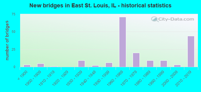
- New bridges - historical statistics
- 3Before 1900
- 51900-1909
- 11910-1919
- 91930-1939
- 21940-1949
- 61950-1959
- 711960-1969
- 201970-1979
- 91980-1989
- 91990-1999
- 32000-2009
- 442010-2019
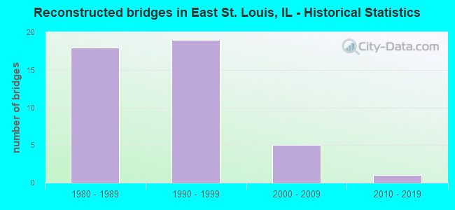
- Reconstructed bridges - Historical Statistics
- 181980-1989
- 191990-1999
- 52000-2009
- 12010-2019
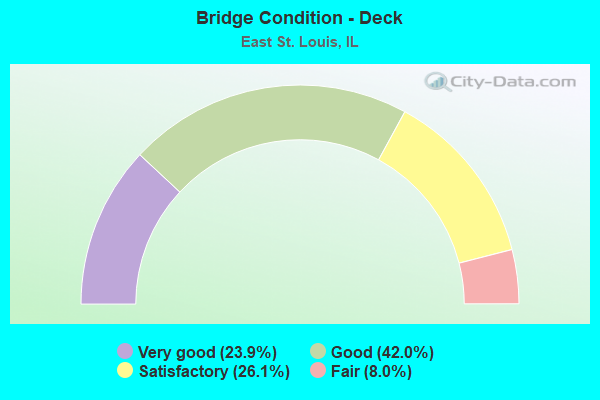
- Bridge Condition - Deck
- 23.9%Very good
- 42.0%Good
- 26.1%Satisfactory
- 8.0%Fair
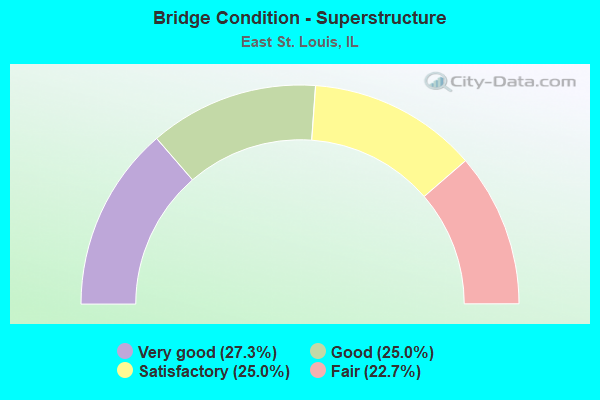
- Bridge Condition - Superstructure
- 27.3%Very good
- 25.0%Good
- 25.0%Satisfactory
- 22.7%Fair
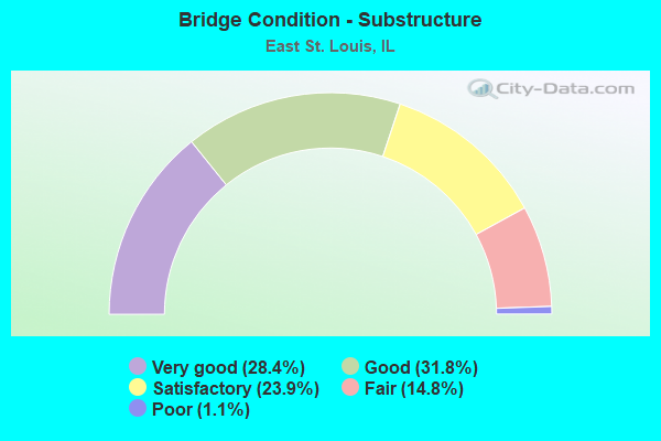
- Bridge Condition - Substructure
- 28.4%Very good
- 31.8%Good
- 23.9%Satisfactory
- 14.8%Fair
- 1.1%Poor
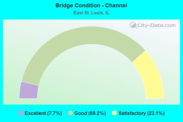
- Bridge Condition - Channel
- 7.7%Excellent
- 69.2%Good
- 23.1%Satisfactory
Find on map >> Show street view
Structure Number: 820325, Location: Flyover to WB I-70 (Lat: 38.633669, Lng: -90.143192), Route carried "under" structure: Other road , Year Built: 2014, Structure Length: 0. m, Average Daily Traffic: 3,150 (year 2018), Truck Traffic: 9%, Features Intersected: 55/70, RR's, and Ramps, Facility Carried by Structure: WB 64 Ramp to WB 7
Minimum Vertical Clearance: 5.28m (17.32ft), Kilometerpoint: 0.048, Lanes on structure: 1, Lanes under structure: 1, Material/Design: Steel continuous, Design/Construction: Stringer/Multi-beam, Length of Maximum Span: 67.8m (222.4ft)
Find on map >> Show street view
Structure Number: 820326, Location: East St. Louis (Lat: 38.631406, Lng: -90.143036), Route carried "under" structure: Interstate 64, Year Built: 2013, Structure Length: 0. m, Average Daily Traffic: 82,900 (year 2021), Truck Traffic: 12%, Features Intersected: FAI 64, Facility Carried by Structure: 9TH STREET
Minimum Vertical Clearance: 5.21m (17.09ft), Kilometerpoint: 4.844, Lanes on structure: 2, Lanes under structure: 8, Material/Design: Steel continuous, Design/Construction: Stringer/Multi-beam, Length of Maximum Span: 49.4m (162.1ft)
Find on map >> Show street view
Structure Number: 820329, Location: 0.8 mi N of I-55/64 (Lat: 38.640511, Lng: -90.155333), Route carried "under" structure: State highway 3, Year Built: 2013, Structure Length: 0. m, Average Daily Traffic: 2,800 (year 2021), Truck Traffic: 13%, Features Intersected: ST CLAIR AV &TRRA RR
Minimum Vertical Clearance: 6.55m (21.49ft), Kilometerpoint: 237.227, Lanes on structure: 2, Lanes under structure: 2, Material/Design: Steel continuous, Design/Construction: Stringer/Multi-beam, Length of Maximum Span: 43.2m (141.7ft)
Find on map >> Show street view
Structure Number: 820349, Location: .70 M E of River (Lat: 38.615325, Lng: -90.173731), Route carried "under" structure: Other road , Year Built: 2015, Structure Length: 0. m, Average Daily Traffic: 1,600 (year 2015), Truck Traffic: 15%, Features Intersected: Reloc IL Rt 3/RR, Facility Carried by Structure: MLK EB to I-55/64
Minimum Vertical Clearance: 5.72m (18.77ft), Kilometerpoint: 5.665, Lanes on structure: 1, Lanes under structure: 4, Material/Design: Steel continuous, Design/Construction: Stringer/Multi-beam, Length of Maximum Span: 46.4m (152.2ft)
Find on map >> Show street view
Structure Number: 820374, Location: .75 E Miss R (Lat: 38.628458, Lng: -90.160611), Route carried "under" structure: Interstate 55, Year Built: 2018, Structure Length: 0. m, Average Daily Traffic: 105,300 (year 2019), Truck Traffic: 10%, Features Intersected: I 55 64WB & MO AV&RR, Facility Carried by Structure: M L King Br Appr
Minimum Vertical Clearance: 7.77m (25.49ft), Kilometerpoint: 2.881, Lanes on structure: 2, Lanes under structure: 3, Material/Design: Steel continuous, Design/Construction: Stringer/Multi-beam, Length of Maximum Span: 86.1m (282.5ft)
Find on map >> Show street view
Structure Number: 820374, Location: .75 E Miss R (Lat: 38.629658, Lng: -90.164467), Route carried "under" structure: Other road , Year Built: 2018, Structure Length: 0. m, Average Daily Traffic: 1,800 (year 2018), Truck Traffic: 14%, Features Intersected: I 55 64WB & MO AV&RR, Facility Carried by Structure: M L King Br Appr
Minimum Vertical Clearance: 5.18m (16.99ft), Kilometerpoint: 3.895, Lanes on structure: 2, Lanes under structure: 4, Material/Design: Steel continuous, Design/Construction: Stringer/Multi-beam, Length of Maximum Span: 86.1m (282.5ft)
Find on map >> Show street view
Structure Number: 820374, Location: .75 E Miss R (Lat: 38.629069, Lng: -90.162319), Route carried "under" structure: Other road , Year Built: 2018, Structure Length: 0. m, Average Daily Traffic: 10 (year 2018), Truck Traffic: 30%, Features Intersected: I 55 64WB & MO AV&RR, Facility Carried by Structure: M L King Br Appr
Minimum Vertical Clearance: 4.90m (16.08ft), Kilometerpoint: 1.110, Lanes on structure: 2, Lanes under structure: 2, Material/Design: Steel continuous, Design/Construction: Stringer/Multi-beam, Length of Maximum Span: 86.1m (282.5ft)
Find on map >> Show street view
Structure Number: 820377, Location: 0.79 E OF FAI 70 (Lat: 38.627181, Lng: -90.138089), Route carried "under" structure: Interstate 64, Year Built: 2012, Structure Length: 0. m, Average Daily Traffic: 82,900 (year 2021), Truck Traffic: 12%, Features Intersected: FAI 64 in E ST Louis, Facility Carried by Structure: 15TH ST-FAU 9155
Minimum Vertical Clearance: 5.69m (18.67ft), Kilometerpoint: 5.472, Lanes on structure: 2, Lanes under structure: 6, Material/Design: Steel continuous, Design/Construction: Stringer/Multi-beam, Length of Maximum Span: 36.2m (118.8ft)
Find on map >> Show street view
Structure Number: 820378, Location: E ST L AT BOWMAN YD (Lat: 38.634197, Lng: -90.140436), Route carried "under" structure: Interstate 55, Year Built: 2011, Structure Length: 0. m, Average Daily Traffic: 67,300 (year 2021), Truck Traffic: 16%, Features Intersected: I-55/70, Facility Carried by Structure: EXCHANGE AVENUE
Minimum Vertical Clearance: 30+ m (98+ ft), Kilometerpoint: 4.796, Lanes on structure: 2, Lanes under structure: 10, Material/Design: Steel continuous, Design/Construction: Stringer/Multi-beam, Length of Maximum Span: 49.7m (163.1ft)
Find on map >> Show street view
Structure Number: 820394, Location: W of 15th STREET (Lat: 38.627956, Lng: -90.138953), Route carried "under" structure: Interstate 64, Year Built: 2010, Structure Length: 0. m, Average Daily Traffic: 82,900 (year 2021), Truck Traffic: 12%, Features Intersected: INTERSTATE 64, Facility Carried by Structure: E ST L PED BRIDGE
Minimum Vertical Clearance: 12.32m (40.42ft), Kilometerpoint: 5.343, Lanes under structure: 6, Material/Design: Steel, Length of Maximum Span: 44.4m (145.7ft)
Find on map >> Show street view
Structure Number: 820399, Location: AT FRENCH VILLAGE (Lat: 38.598822, Lng: -90.053139), Route carried "under" structure: State highway 161, Year Built: 2017, Structure Length: 0. m, Average Daily Traffic: 17,400 (year 2021), Truck Traffic: 6%, Features Intersected: ST CL AVE,METRO,CRK, Facility Carried by Structure: IL 157
Minimum Vertical Clearance: 7.82m (25.66ft), Kilometerpoint: 0.000, Lanes on structure: 4, Lanes under structure: 4, Material/Design: Steel continuous, Design/Construction: Stringer/Multi-beam, Length of Maximum Span: 34.1m (111.9ft)
Find on map >> Show street view
Structure Number: 826001, Location: East St. Louis (Lat: 38.630314, Lng: -90.172392), Route carried "under" structure: City street , Year Built: 1950, Structure Length: 0. m, Average Daily Traffic: 1,250 (year 2018), Truck Traffic: 46%, Features Intersected: Mississippi Rv/RR/MS-600, Facility Carried by Structure: FAP-799
Minimum Vertical Clearance: 30+ m (98+ ft), Kilometerpoint: 0.949, Lanes on structure: 3, Lanes under structure: 2, Material/Design: Steel continuous, Design/Construction: Truss - Thru, Length of Maximum Span: 293.5m (962.9ft)
Find on map >> Show street view
Structure Number: 826001, Location: East St. Louis (Lat: 38.630492, Lng: -90.174661), Route carried "under" structure: City street , Year Built: 1950, Structure Length: 0. m, Average Daily Traffic: 1,000 (year 2018), Truck Traffic: 49%, Features Intersected: Mississippi Rv/RR/MS-600, Facility Carried by Structure: FAP-799
Minimum Vertical Clearance: 8.08m (26.51ft), Kilometerpoint: 1.464, Lanes on structure: 3, Lanes under structure: 2, Material/Design: Steel continuous, Design/Construction: Truss - Thru, Length of Maximum Span: 293.5m (962.9ft)
Find on map >> Show street view
Structure Number: 826006, Location: 0.1 Mi E 3rd ST EXIT (Lat: 38.629264, Lng: -90.158275), Route carried "under" structure: Other road , Year Built: 1961, Structure Length: 0. m, Average Daily Traffic: 800 (year 2020), Features Intersected: RAMP TO WB MLK BR, Facility Carried by Structure: MLK BR APPR EB & W
Minimum Vertical Clearance: 4.65m (15.26ft), Kilometerpoint: 0.225, Lanes on structure: 2, Lanes under structure: 1, Material/Design: Steel, Design/Construction: Stringer/Multi-beam, Length of Maximum Span: 16.7m (54.8ft)
Find on map >> Show street view
Structure Number: 829905, Location: .8 W ILL 111 (Lat: 38.615497, Lng: -90.107222), Route carried "under" structure: Other road , Year Built: 1940, Structure Length: 0. m, Average Daily Traffic: 6,600 (year 2018), Truck Traffic: 6%, Features Intersected: ST CLAIR AVE, Facility Carried by Structure: A & S RR
Minimum Vertical Clearance: 4.45m (14.60ft), Kilometerpoint: 7.869, Lanes under structure: 4, Material/Design: Steel, Design/Construction: Stringer/Multi-beam, Length of Maximum Span: 10.7m (35.1ft)
Find on map >> Show street view
Structure Number: 829911, Location: 1 M NW I-55-70 (Lat: 38.635400, Lng: -90.149094), Route carried "under" structure: State highway 3, Year Built: 1938, Structure Length: 0. m, Average Daily Traffic: 4,250 (year 2021), Truck Traffic: 17%, Features Intersected: ILL 3, Facility Carried by Structure: CSX R.R.
Minimum Vertical Clearance: 4.42m (14.50ft), Kilometerpoint: 236.438, Lanes under structure: 4, Material/Design: Steel, Design/Construction: Girder and Floorbeam System, Length of Maximum Span: 16.5m (54.1ft)
Find on map >> Show street view
Structure Number: 829912, Location: 1 M NW I-55-70 (Lat: 38.634372, Lng: -90.147864), Route carried "under" structure: State highway 3, Year Built: 1938, Structure Length: 0. m, Average Daily Traffic: 4,250 (year 2021), Truck Traffic: 17%, Features Intersected: ILL 3, Facility Carried by Structure: CSX R.R.
Minimum Vertical Clearance: 4.39m (14.40ft), Kilometerpoint: 236.245, Lanes under structure: 4, Material/Design: Steel, Design/Construction: Girder and Floorbeam System, Length of Maximum Span: 14.6m (47.9ft)
Find on map >> Show street view
Structure Number: 829913, Location: .5 M NW I-55-70 (Lat: 38.634283, Lng: -90.147761), Route carried "under" structure: State highway 3, Year Built: 1938, Structure Length: 0. m, Average Daily Traffic: 4,250 (year 2021), Truck Traffic: 17%, Features Intersected: ILL 3, Facility Carried by Structure: CSX R.R
Minimum Vertical Clearance: 4.39m (14.40ft), Kilometerpoint: 236.229, Lanes under structure: 4, Material/Design: Steel, Design/Construction: Girder and Floorbeam System, Length of Maximum Span: 14.6m (47.9ft)
Find on map >> Show street view
Structure Number: 829916, Location: E ST LOUIS (Lat: 38.615844, Lng: -90.166478), Route carried "under" structure: Other road , Year Built: 1936, Structure Length: 0. m, Average Daily Traffic: 3,150 (year 2018), Truck Traffic: 10%, Features Intersected: 8TH ST/ FAU 9217B, Facility Carried by Structure: SOUTHERN RR
Minimum Vertical Clearance: 4.27m (14.01ft), Kilometerpoint: 0.982, Lanes under structure: 2, Material/Design: Steel, Design/Construction: Girder and Floorbeam System, Length of Maximum Span: 17.7m (58.1ft)
Find on map >> Show street view
Structure Number: 829917, Location: E ST LOUIS (Lat: 38.610919, Lng: -90.169872), Route carried "under" structure: Other road , Year Built: 1918, Structure Length: 0. m, Average Daily Traffic: 3,150 (year 2018), Truck Traffic: 10%, Features Intersected: 8TH ST/ FAU 9217, Facility Carried by Structure: A & S RR
Minimum Vertical Clearance: 6.76m (22.18ft), Kilometerpoint: 1.609, Lanes under structure: 2, Material/Design: Steel, Design/Construction: Girder and Floorbeam System, Length of Maximum Span: 20.7m (67.9ft)
Find on map >> Show street view
Structure Number: 829918, Location: 1.3 M S ILL 15 (Lat: 38.607347, Lng: -90.170933), Route carried "under" structure: Other road , Year Built: 1937, Structure Length: 0. m, Average Daily Traffic: 3,150 (year 2018), Truck Traffic: 10%, Features Intersected: 8TH ST/ FAU 9217B, Facility Carried by Structure: IC RR
Minimum Vertical Clearance: 4.34m (14.24ft), Kilometerpoint: 2.012, Lanes under structure: 2, Material/Design: Steel, Design/Construction: Girder and Floorbeam System, Length of Maximum Span: 29.3m (96.1ft)
Find on map >> Show street view
Structure Number: 829919, Location: E.ST.LOUIS (Lat: 38.618011, Lng: -90.132300), Route carried "under" structure: Other road , Year Built: 1900, Structure Length: 0. m, Average Daily Traffic: 7,500 (year 2018), Truck Traffic: 4%, Features Intersected: STATE ST/ FAU 9182, Facility Carried by Structure: TRRA R.R.
Minimum Vertical Clearance: 4.32m (14.17ft), Kilometerpoint: 1.770, Lanes under structure: 4, Material/Design: Steel, Design/Construction: Girder and Floorbeam System, Length of Maximum Span: 11.9m (39.0ft)
Find on map >> Show street view
Structure Number: 829921, Location: E ST LOUIS (Lat: 38.603711, Lng: -90.153628), Route carried "under" structure: Other road , Year Built: 1900, Structure Length: 0. m, Average Daily Traffic: 2,450 (year 2018), Truck Traffic: 5%, Features Intersected: 19TH ST/ FAU 9225, Facility Carried by Structure: A & S RR
Minimum Vertical Clearance: 5.31m (17.42ft), Kilometerpoint: 0.531, Lanes under structure: 2, Material/Design: Steel, Design/Construction: Girder and Floorbeam System, Length of Maximum Span: 16.5m (54.1ft)
Find on map >> Show street view
Structure Number: 829929, Location: E ST LOUIS (Lat: 38.628575, Lng: -90.175036), Route carried "under" structure: City street , Year Built: 1874, Structure Length: 0. m, Average Daily Traffic: 700 (year 2018), Truck Traffic: 2%, Features Intersected: MISS RIV/RR/MSS6000, Facility Carried by Structure: FAU 9187A & MET LI
Minimum Vertical Clearance: 8.92m (29.27ft), Kilometerpoint: 1.674, Lanes on structure: 4, Lanes under structure: 2, Material/Design: Steel, Length of Maximum Span: 158.5m (520.0ft)
Find on map >> Show street view
Structure Number: 829931, Location: E.ST.LOUIS (Lat: 38.627811, Lng: -90.165139), Route carried "under" structure: Other road , Year Built: 1900, Structure Length: 0. m, Average Daily Traffic: 9,600 (year 2018), Truck Traffic: 4%, Features Intersected: BROADWAY/ FAU 9187A, Facility Carried by Structure: TRRA&SOUTHERN R.R.
Minimum Vertical Clearance: 4.34m (14.24ft), Kilometerpoint: 1.191, Lanes under structure: 4, Material/Design: Steel, Design/Construction: Girder and Floorbeam System, Length of Maximum Span: 22.3m (73.2ft)
Find on map >> Show street view
Structure Number: 829932, Location: E.ST.LOUIS (Lat: 38.627697, Lng: -90.164950), Route carried "under" structure: Other road , Year Built: 1900, Structure Length: 0. m, Average Daily Traffic: 9,600 (year 2018), Truck Traffic: 4%, Features Intersected: TRENDLEY/ FAU 9187A, Facility Carried by Structure: TRRA R.R.
Minimum Vertical Clearance: 4.34m (14.24ft), Kilometerpoint: 1.223, Lanes under structure: 4, Material/Design: Steel, Design/Construction: Girder and Floorbeam System, Length of Maximum Span: 22.3m (73.2ft)
Find on map >> Show street view
Structure Number: 829948, Location: .03MI EAST OF 11TH (Lat: 38.629200, Lng: -90.141806), Route carried "under" structure: Other road , Year Built: 1999, Structure Length: 0. m, Average Daily Traffic: 4,700 (year 2018), Truck Traffic: 9%, Features Intersected: ST. CLAIR AVE, Facility Carried by Structure: METRO LINK
Minimum Vertical Clearance: 5.03m (16.50ft), Kilometerpoint: 4.458, Lanes under structure: 3, Material/Design: Steel continuous, Design/Construction: Girder and Floorbeam System, Length of Maximum Span: 27.4m (89.9ft)
Find on map >> Show street view
Structure Number: 829949, Location: 0.01 S OF ST. CLAIR (Lat: 38.603519, Lng: -90.064511), Route carried "under" structure: Other road , Year Built: 1999, Structure Length: 0. m, Average Daily Traffic: 2,850 (year 2018), Truck Traffic: 5%, Features Intersected: 79TH ST, Facility Carried by Structure: METRO LINK
Minimum Vertical Clearance: 5.33m (17.49ft), Kilometerpoint: 0.016, Lanes under structure: 2, Material/Design: Steel continuous, Design/Construction: Girder and Floorbeam System, Length of Maximum Span: 22.9m (75.1ft)
Find on map >> Show street view
Structure Number: 82995, Location: 1-64/BAUGH AVE (Lat: 38.629564, Lng: -90.140781), Route carried "under" structure: Interstate 64, Year Built: 1999, Structure Length: 0. m, Average Daily Traffic: 82,900 (year 2021), Truck Traffic: 12%, Features Intersected: FAI 64&BAUGH AVE, Facility Carried by Structure: METRO LINK
Minimum Vertical Clearance: 9.14m (29.99ft), Kilometerpoint: 5.069, Lanes under structure: 3, Material/Design: Steel continuous, Design/Construction: Girder and Floorbeam System, Length of Maximum Span: 36.6m (120.1ft)
Find on map >> Show street view
Structure Number: 82995, Location: 1-64/BAUGH AVE (Lat: 38.629944, Lng: -90.140236), Route carried "under" structure: Other road , Year Built: 1999, Structure Length: 0. m, Average Daily Traffic: 1,225 (year 2018), Truck Traffic: 12%, Features Intersected: FAI 64&BAUGH AVE, Facility Carried by Structure: METRO LINK
Minimum Vertical Clearance: 9.14m (29.99ft), Kilometerpoint: 0.708, Lanes under structure: 3, Material/Design: Steel continuous, Design/Construction: Girder and Floorbeam System, Length of Maximum Span: 36.6m (120.1ft)
Find on map >> Show street view
Structure Number: 829966, Location: 05M W MAINON TRENDLE (Lat: 38.621508, Lng: -90.169839), Route carried "under" structure: Other road , Year Built: 1890, Structure Length: 0. m, Average Daily Traffic: 300 (year 2018), Truck Traffic: 23%, Features Intersected: TRENDLEY AV/FAU 9188, Facility Carried by Structure: TRRA
Minimum Vertical Clearance: 3.05m (10.01ft), Kilometerpoint: 0.547, Lanes under structure: 2, Material/Design: Concrete, Design/Construction: Girder and Floorbeam System, Length of Maximum Span: 11.0m (36.1ft)