Bridge Statistics for Fayetteville, Arkansas (AR)
Condition, Traffic, Stress, Structural Evaluation, Project Costs
- National Bridge Inventory (NBI) Statistics
- 163Number of bridges
- 1,385ft / 422mTotal length
- $4,309,000Total costs
- 2,294,234Total average daily traffic
- 103,966Total average daily truck traffic
- National Bridge Inventory (NBI) Registered Bridges for Fayetteville
- No street view available for this location
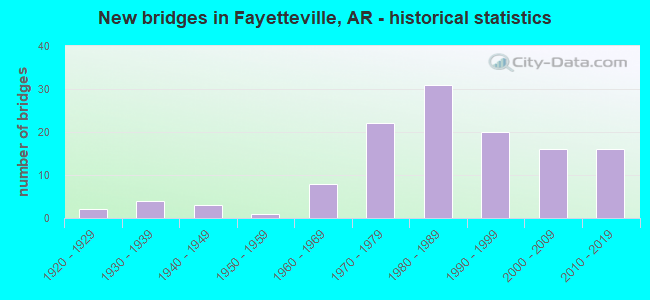
- New bridges - historical statistics
- 21920-1929
- 41930-1939
- 31940-1949
- 11950-1959
- 81960-1969
- 221970-1979
- 311980-1989
- 201990-1999
- 162000-2009
- 162010-2019
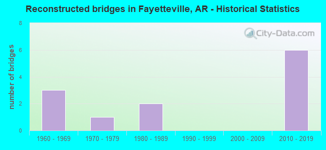
- Reconstructed bridges - Historical Statistics
- 31960-1969
- 11970-1979
- 21980-1989
- 01990-1999
- 02000-2009
- 62010-2019
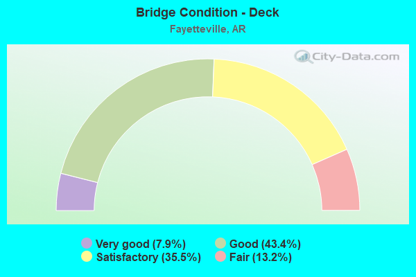
- Bridge Condition - Deck
- 7.9%Very good
- 43.4%Good
- 35.5%Satisfactory
- 13.2%Fair
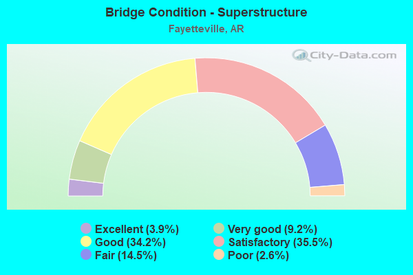
- Bridge Condition - Superstructure
- 3.9%Excellent
- 9.2%Very good
- 34.2%Good
- 35.5%Satisfactory
- 14.5%Fair
- 2.6%Poor
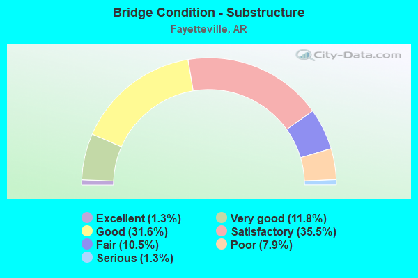
- Bridge Condition - Substructure
- 1.3%Excellent
- 11.8%Very good
- 31.6%Good
- 35.5%Satisfactory
- 10.5%Fair
- 7.9%Poor
- 1.3%Serious
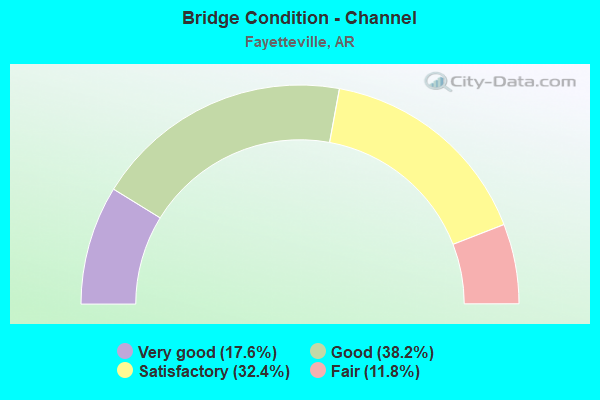
- Bridge Condition - Channel
- 17.6%Very good
- 38.2%Good
- 32.4%Satisfactory
- 11.8%Fair
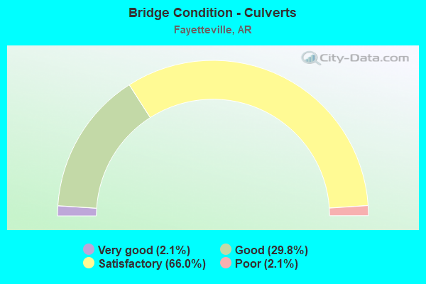
- Bridge Condition - Culverts
- 2.1%Very good
- 29.8%Good
- 66.0%Satisfactory
- 2.1%Poor
Find on map >> Show street view
Structure Number: A0698, Location: 1.98 MI N INT 71 & 71B (Lat: 36.119411, Lng: -94.144800), Route carried "on" structure: Business US 71, Year Built: 1928, Year Reconstructed: 1971, Status: Open, Structure Length: 2.74m (8.99ft), Average Daily Traffic: 31,000 (year 2018), Truck Traffic: 1%, Average Future Daily Traffic: 24,613 (year 2028), Design Load: H 20, Features Intersected: Mud Creek-Washington
Minimum Vertical Clearance: 30+ m (98+ ft), Kilometerpoint: 2.929, Lanes on structure: 3, Base Highway Network: Yes, Owner: State Highway Agency, Approaching Roadway Width: 17.7m (58.1ft), Skew: 10 degrees, Material/Design: Concrete, Design/Construction: Tee Beam, Number Of Spans In Main Unit: 3, Length of Maximum Span: 9.1m (29.9ft), Curb or Sidewalk Widths: Left: 0.1m (0.3ft), Right: 0.1m (0.3ft), Curb-To-Curb Width: 17.4m (57.1ft), Out-to-Out Width: 18.3m (60.0ft)
Condition: Deck: Fair, Superstructure: Fair, Substructure: Fair, Channel: Satisfactory, Operating Rating: 53.5 metric tons, Method Used To Determine Operating Rating: Load Factor (LF), Inventory Rating: 32.7 metric tons, Method Used To Determine Inventory Rating: Load Factor (LF), Structural Evaluation: Somewhat better than minimum adequacy, Deck Geometry: Superior to present desirable criteria, Waterway Adequacy: Equal to present desirable criteria, Approach Roadway Alignment: Equal to present desirable criteria, Designated Inspection Frequency: Every 24 months, Critical Feature Inspection Frequency: Every 24 months, Inspection Date: November 2021, Deck Structure Type: Concrete Cast-file-Place, Wearing Surface/Protective System: Wearing Surface: Bituminous
Find on map >> Show street view
Structure Number: A5392, Location: 5.47 MI S BENTON CO LINE (Lat: 36.132450, Lng: -94.145850), Route carried "on" structure: Business US 71, Year Built: 1972, Status: Open, Structure Length: 3.96m (12.99ft), Average Daily Traffic: 18,500 (year 2018), Truck Traffic: 1%, Average Future Daily Traffic: 23,910 (year 2028), Design Load: HS 20, Features Intersected: Clear Creek- Washington
Minimum Vertical Clearance: 30+ m (98+ ft), Kilometerpoint: 4.394, Lanes on structure: 3, Base Highway Network: Yes, Owner: State Highway Agency, Approaching Roadway Width: 14.0m (45.9ft), Skew: 11 degrees, Material/Design: Concrete continuous, Design/Construction: Slab, Number Of Spans In Main Unit: 3, Length of Maximum Span: 15.5m (50.9ft), Curb or Sidewalk Widths: Left: 0.2m (0.7ft), Right: 0.2m (0.7ft), Curb-To-Curb Width: 13.7m (44.9ft), Out-to-Out Width: 14.7m (48.2ft)
Condition: Deck: Fair, Superstructure: Fair, Substructure: Good, Channel: Very good, Operating Rating: 54.4 metric tons, Method Used To Determine Operating Rating: Load Factor (LF), Inventory Rating: 32.7 metric tons, Method Used To Determine Inventory Rating: Load Factor (LF), Structural Evaluation: Somewhat better than minimum adequacy, Deck Geometry: Somewhat better than minimum adequacy, Waterway Adequacy: Equal to present desirable criteria, Approach Roadway Alignment: Equal to present desirable criteria, Designated Inspection Frequency: Every 24 months, Critical Feature Inspection Frequency: Every 24 months, Inspection Date: November 2021, Deck Structure Type: Concrete Cast-file-Place, Wearing Surface/Protective System: Wearing Surface: Monolithic Concrete
Find on map >> Show street view
Structure Number: A5802, Location: 5.21 NO JCT US 62 & 71 (Lat: 36.111450, Lng: -94.164081), Route carried "on" structure: Business US 71, Year Built: 1979, Status: Open, Structure Length: 9.85m (32.32ft), Average Daily Traffic: 13,000 (year 2018), Truck Traffic: 1%, Average Future Daily Traffic: 29,536 (year 2028), Design Load: HS 20, Features Intersected: Gregg Ave, A&M RR
Minimum Vertical Clearance: 30+ m (98+ ft), Kilometerpoint: 0.869, Lanes on structure: 3, Lanes under structure: 5, Base Highway Network: Yes, Owner: State Highway Agency, Approaching Roadway Width: 14.6m (47.9ft), Skew: 2 degrees, Material/Design: Steel continuous, Design/Construction: Stringer/Multi-beam, Number Of Spans In Main Unit: 4, Length of Maximum Span: 28.7m (94.2ft), Curb-To-Curb Width: 14.6m (47.9ft), Out-to-Out Width: 15.5m (50.9ft)
Condition: Deck: Fair, Superstructure: Satisfactory, Substructure: Very good, Operating Rating: 54.4 metric tons, Method Used To Determine Operating Rating: Load Factor (LF), Inventory Rating: 32.7 metric tons, Method Used To Determine Inventory Rating: Load Factor (LF), Structural Evaluation: Equal to present minimum criteria, Deck Geometry: Meets minimum limits, Underclear: Somewhat better than minimum adequacy, Approach Roadway Alignment: Equal to present desirable criteria, Designated Inspection Frequency: Every 24 months, Critical Feature Inspection Frequency: Every 24 months, Inspection Date: December 2021, Deck Structure Type: Concrete Cast-file-Place, Wearing Surface/Protective System: Wearing Surface: Monolithic Concrete
Find on map >> Show street view
Structure Number: A5818, Location: 0.4 MI N 71 71 B INTER (Lat: 36.031519, Lng: -94.178569), Route carried "on" structure: US 71, Year Built: 1979, Status: Open, Structure Length: 6.31m (20.70ft), Average Daily Traffic: 980 (year 2018), Truck Traffic: 1%, Average Future Daily Traffic: 6,399 (year 2028), Design Load: HS 20, Features Intersected: STL / SF RR - Wash. Co., Facility Carried by Structure: Fulbright Exp.
Minimum Vertical Clearance: 30+ m (98+ ft), Kilometerpoint: 36.653, Lanes on structure: 2, Base Highway Network: Yes, Owner: State Highway Agency, Approaching Roadway Width: 12.2m (40.0ft), Skew: 4 degrees, Material/Design: Steel continuous, Design/Construction: Stringer/Multi-beam, Number Of Spans In Main Unit: 3, Length of Maximum Span: 24.4m (80.1ft), Curb-To-Curb Width: 12.2m (40.0ft), Out-to-Out Width: 13.0m (42.7ft)
Condition: Deck: Satisfactory, Superstructure: Satisfactory, Substructure: Satisfactory, Operating Rating: 54.4 metric tons, Method Used To Determine Operating Rating: Load Factor (LF), Inventory Rating: 32.7 metric tons, Method Used To Determine Inventory Rating: Load Factor (LF), Structural Evaluation: Equal to present minimum criteria, Deck Geometry: Better than present minimum criteria, Underclear: Better than present minimum criteria, Approach Roadway Alignment: Equal to present desirable criteria, Designated Inspection Frequency: Every 24 months, Critical Feature Inspection Frequency: Every 24 months, Inspection Date: August 2021, Deck Structure Type: Concrete Cast-file-Place, Wearing Surface/Protective System: Wearing Surface: Monolithic Concrete
Find on map >> Show street view
Structure Number: A5919, Location: 2.13 MI NO OF I-49 (Lat: 36.134331, Lng: -94.182250), Route carried "on" structure: Interstate 49, Year Built: 1984, Year Reconstructed: 2017, Status: Open, Structure Length: 10.88m (35.70ft), Average Daily Traffic: 13,500 (year 2018), Truck Traffic: 11%, Average Future Daily Traffic: 54,000 (year 2035), Design Load: HS 20+Mod, Features Intersected: Clear Creek - Wash Co.
Minimum Vertical Clearance: 30+ m (98+ ft), Kilometerpoint: 110.506, Lanes on structure: 4, Base Highway Network: Yes, Owner: State Highway Agency, Approaching Roadway Width: 21.3m (69.9ft), Skew: 11 degrees, Material/Design: Prestressed concrete, Design/Construction: Stringer/Multi-beam, Number Of Spans In Main Unit: 5, Length of Maximum Span: 21.6m (70.9ft), Curb-To-Curb Width: 21.3m (69.9ft), Out-to-Out Width: 22.2m (72.8ft)
Condition: Deck: Satisfactory, Superstructure: Satisfactory, Substructure: Satisfactory, Channel: Very good, Operating Rating: 54.4 metric tons, Method Used To Determine Operating Rating: Load Factor (LF), Inventory Rating: 32.7 metric tons, Method Used To Determine Inventory Rating: Load Factor (LF), Structural Evaluation: Equal to present minimum criteria, Deck Geometry: Better than present minimum criteria, Waterway Adequacy: Superior to present desirable criteria, Approach Roadway Alignment: Equal to present desirable criteria, Designated Inspection Frequency: Every 24 months, Critical Feature Inspection Frequency: Every 24 months, Inspection Date: December 2021, Deck Structure Type: Concrete Cast-file-Place, Wearing Surface/Protective System: Wearing Surface: Monolithic Concrete
Find on map >> Show street view
Structure Number: A592, Location: 2.35 N INTER I-49 & 71B (Lat: 36.138331, Lng: -94.182950), Route carried "on" structure: Interstate 49, Year Built: 1984, Year Reconstructed: 2017, Status: Open, Structure Length: 5.97m (19.59ft), Average Daily Traffic: 34,000 (year 2018), Truck Traffic: 11%, Average Future Daily Traffic: 54,000 (year 2033), Design Load: HS 20+Mod, Features Intersected: Johnson Mill Blvd.
Minimum Vertical Clearance: 30.44m (99.87ft), Kilometerpoint: 110.951, Lanes on structure: 3, Lanes under structure: 4, Base Highway Network: Yes, Owner: State Highway Agency, Approaching Roadway Width: 19.2m (63.0ft), Skew: 2 degrees, Material/Design: Steel continuous, Design/Construction: Stringer/Multi-beam, Number Of Spans In Main Unit: 3, Length of Maximum Span: 26.2m (86.0ft), Curb-To-Curb Width: 18.9m (62.0ft), Out-to-Out Width: 19.8m (65.0ft)
Condition: Deck: Satisfactory, Superstructure: Good, Substructure: Good, Operating Rating: 54.4 metric tons, Method Used To Determine Operating Rating: Load Factor (LF), Inventory Rating: 32.7 metric tons, Method Used To Determine Inventory Rating: Load Factor (LF), Structural Evaluation: Better than present minimum criteria, Deck Geometry: Superior to present desirable criteria, Underclear: Better than present minimum criteria, Approach Roadway Alignment: Equal to present desirable criteria, Designated Inspection Frequency: Every 24 months, Critical Feature Inspection Frequency: Every 24 months, Inspection Date: December 2021, Deck Structure Type: Concrete Cast-file-Place, Wearing Surface/Protective System: Wearing Surface: Monolithic Concrete
Find on map >> Show street view
Structure Number: A6243, Location: JCT I 49 & SH 265 (Lat: 36.033331, Lng: -94.188200), Route carried "on" structure: Interstate 49, Year Built: 1994, Status: Open, Structure Length: 7.41m (24.31ft), Average Daily Traffic: 16,056 (year 2018), Truck Traffic: 1%, Average Future Daily Traffic: 23,910 (year 2028), Design Load: HS 20+Mod, Features Intersected: State Highway 265
Minimum Vertical Clearance: 30+ m (98+ ft), Kilometerpoint: 97.365, Lanes on structure: 2, Lanes under structure: 2, Base Highway Network: Yes, Owner: State Highway Agency, Approaching Roadway Width: 12.2m (40.0ft), Skew: 4 degrees, Material/Design: Steel continuous, Design/Construction: Stringer/Multi-beam, Number Of Spans In Main Unit: 3, Length of Maximum Span: 30.5m (100.1ft), Curb-To-Curb Width: 12.2m (40.0ft), Out-to-Out Width: 13.1m (43.0ft)
Condition: Deck: Satisfactory, Superstructure: Good, Substructure: Satisfactory, Operating Rating: 54.4 metric tons, Method Used To Determine Operating Rating: Load Factor (LF), Inventory Rating: 32.7 metric tons, Method Used To Determine Inventory Rating: Load Factor (LF), Structural Evaluation: Equal to present minimum criteria, Deck Geometry: Better than present minimum criteria, Underclear: Superior to present desirable criteria, Approach Roadway Alignment: Equal to present desirable criteria, Designated Inspection Frequency: Every 24 months, Critical Feature Inspection Frequency: Every 24 months, Inspection Date: June 2020, Deck Structure Type: Concrete Cast-file-Place, Wearing Surface/Protective System: Wearing Surface: Monolithic Concrete, Deck Protection: Epoxy Coated Reinforcing
Find on map >> Show street view
Structure Number: A738, Location: I-49 & US 71B (Lat: 36.109061, Lng: -94.170381), Route carried "on" structure: Interstate 49, Year Built: 2017, Status: Open, Structure Length: 11.16m (36.61ft), Average Daily Traffic: 3,500 (year 2018), Truck Traffic: 12%, Average Future Daily Traffic: 135,000 (year 2036), Design Load: HL 93, Features Intersected: US 71B MN LNS - Wash Co
Minimum Vertical Clearance: 30+ m (98+ ft), Kilometerpoint: 107.343, Lanes on structure: 3, Lanes under structure: 3, Base Highway Network: Yes (Inventory Route: 490, Subroute: 1), Owner: State Highway Agency, Approaching Roadway Width: 12.2m (40.0ft), Skew: 4 degrees, Material/Design: Steel continuous, Design/Construction: Stringer/Multi-beam, Number Of Spans In Main Unit: 2, Length of Maximum Span: 55.5m (182.1ft), Curb-To-Curb Width: 17.7m (58.1ft), Out-to-Out Width: 18.6m (61.0ft)
Condition: Deck: Very good, Superstructure: Excellent, Substructure: Very good, Operating Rating: 54.4 metric tons, Method Used To Determine Operating Rating: Load and Resistance Factor (LRFR), Inventory Rating: 32.7 metric tons, Method Used To Determine Inventory Rating: Load and Resistance Factor (LRFR), Structural Evaluation: Equal to present desirable criteria, Deck Geometry: Better than present minimum criteria, Underclear: Somewhat better than minimum adequacy, Approach Roadway Alignment: Superior to present desirable criteria, Designated Inspection Frequency: Every 24 months, Critical Feature Inspection Frequency: Every 24 months, Inspection Date: December 2021, Deck Structure Type: Concrete Cast-file-Place, Wearing Surface/Protective System: Wearing Surface: Monolithic Concrete
Find on map >> Show street view
Structure Number: B5392, Location: 5.47 MI SO BENTON CO LINE (Lat: 36.132511, Lng: -94.145600), Route carried "on" structure: Business US 71, Year Built: 1972, Status: Open, Structure Length: 3.90m (12.80ft), Average Daily Traffic: 18,500 (year 2018), Truck Traffic: 1%, Average Future Daily Traffic: 23,910 (year 2028), Design Load: HS 20, Features Intersected: Clear Creek-Washington
Minimum Vertical Clearance: 30+ m (98+ ft), Kilometerpoint: 4.394, Lanes on structure: 3, Base Highway Network: Yes, Owner: State Highway Agency, Approaching Roadway Width: 15.2m (49.9ft), Skew: 11 degrees, Material/Design: Concrete continuous, Design/Construction: Slab, Number Of Spans In Main Unit: 3, Length of Maximum Span: 15.2m (49.9ft), Curb or Sidewalk Widths: Left: 0.2m (0.7ft), Right: 0.2m (0.7ft), Curb-To-Curb Width: 14.9m (48.9ft), Out-to-Out Width: 15.9m (52.2ft)
Condition: Deck: Fair, Superstructure: Fair, Substructure: Satisfactory, Channel: Very good, Operating Rating: 54.4 metric tons, Method Used To Determine Operating Rating: Load Factor (LF), Inventory Rating: 32.7 metric tons, Method Used To Determine Inventory Rating: Load Factor (LF), Structural Evaluation: Somewhat better than minimum adequacy, Deck Geometry: Equal to present minimum criteria, Waterway Adequacy: Equal to present desirable criteria, Approach Roadway Alignment: Equal to present desirable criteria, Designated Inspection Frequency: Every 24 months, Critical Feature Inspection Frequency: Every 24 months, Inspection Date: November 2021, Deck Structure Type: Concrete Cast-file-Place, Wearing Surface/Protective System: Wearing Surface: Monolithic Concrete
Find on map >> Show street view
Structure Number: B5802, Location: 5.21 NO JCT US 62 & 71 (Lat: 36.111150, Lng: -94.164069), Route carried "on" structure: Business US 71, Year Built: 1979, Status: Open, Structure Length: 9.85m (32.32ft), Average Daily Traffic: 41,000 (year 2018), Truck Traffic: 3%, Average Future Daily Traffic: 54,000 (year 2038), Design Load: HS 20, Features Intersected: Gregg Ave., A&M RR.
Minimum Vertical Clearance: 30+ m (98+ ft), Kilometerpoint: 0.869, Lanes on structure: 2, Lanes under structure: 5, Base Highway Network: Yes, Owner: State Highway Agency, Approaching Roadway Width: 12.2m (40.0ft), Skew: 2 degrees, Material/Design: Steel continuous, Design/Construction: Stringer/Multi-beam, Number Of Spans In Main Unit: 4, Length of Maximum Span: 28.7m (94.2ft), Curb-To-Curb Width: 12.2m (40.0ft), Out-to-Out Width: 13.0m (42.7ft)
Condition: Deck: Satisfactory, Superstructure: Satisfactory, Substructure: Good, Operating Rating: 54.4 metric tons, Method Used To Determine Operating Rating: Load Factor (LF), Inventory Rating: 32.7 metric tons, Method Used To Determine Inventory Rating: Load Factor (LF), Structural Evaluation: Equal to present minimum criteria, Deck Geometry: Better than present minimum criteria, Underclear: Somewhat better than minimum adequacy, Approach Roadway Alignment: Equal to present desirable criteria, Designated Inspection Frequency: Every 24 months, Critical Feature Inspection Frequency: Every 24 months, Inspection Date: December 2021, Deck Structure Type: Concrete Cast-file-Place, Wearing Surface/Protective System: Wearing Surface: Monolithic Concrete
Find on map >> Show street view
Structure Number: B5818, Location: 0.4 MI N 71-71B INTER (Lat: 36.031881, Lng: -94.178639), Route carried "on" structure: US 71, Year Built: 1979, Status: Open, Structure Length: 6.31m (20.70ft), Average Daily Traffic: 13,000 (year 2018), Truck Traffic: 8%, Average Future Daily Traffic: 17,100 (year 2038), Design Load: HS 20, Features Intersected: ST L - SF RAILROAD
Minimum Vertical Clearance: 30+ m (98+ ft), Kilometerpoint: 36.653, Lanes on structure: 2, Base Highway Network: Yes, Owner: State Highway Agency, Approaching Roadway Width: 12.2m (40.0ft), Skew: 4 degrees, Material/Design: Steel continuous, Design/Construction: Stringer/Multi-beam, Number Of Spans In Main Unit: 3, Length of Maximum Span: 24.4m (80.1ft), Curb-To-Curb Width: 12.2m (40.0ft), Out-to-Out Width: 13.0m (42.7ft)
Condition: Deck: Good, Superstructure: Satisfactory, Substructure: Good, Operating Rating: 54.4 metric tons, Method Used To Determine Operating Rating: Load Factor (LF), Inventory Rating: 32.7 metric tons, Method Used To Determine Inventory Rating: Load Factor (LF), Structural Evaluation: Equal to present minimum criteria, Deck Geometry: Better than present minimum criteria, Underclear: Superior to present desirable criteria, Approach Roadway Alignment: Equal to present desirable criteria, Designated Inspection Frequency: Every 24 months, Critical Feature Inspection Frequency: Every 24 months, Inspection Date: August 2021, Deck Structure Type: Concrete Cast-file-Place, Wearing Surface/Protective System: Wearing Surface: Monolithic Concrete
Find on map >> Show street view
Structure Number: B5919, Location: 2.2 MI N INT I-49&71B (Lat: 36.134300, Lng: -94.181911), Route carried "on" structure: Interstate 49, Year Built: 1984, Year Reconstructed: 2017, Status: Open, Structure Length: 10.88m (35.70ft), Average Daily Traffic: 13,500 (year 2018), Truck Traffic: 11%, Average Future Daily Traffic: 54,000 (year 2033), Design Load: HS 20+Mod, Features Intersected: Clear Creek - Wash. Co.
Minimum Vertical Clearance: 30+ m (98+ ft), Kilometerpoint: 110.499, Lanes on structure: 4, Base Highway Network: Yes, Owner: State Highway Agency, Approaching Roadway Width: 19.2m (63.0ft), Skew: 1 degrees, Material/Design: Prestressed concrete, Design/Construction: Stringer/Multi-beam, Number Of Spans In Main Unit: 5, Length of Maximum Span: 21.6m (70.9ft), Curb-To-Curb Width: 18.9m (62.0ft), Out-to-Out Width: 19.8m (65.0ft)
Condition: Deck: Satisfactory, Superstructure: Good, Substructure: Satisfactory, Channel: Very good, Operating Rating: 54.4 metric tons, Method Used To Determine Operating Rating: Load Factor (LF), Inventory Rating: 32.7 metric tons, Method Used To Determine Inventory Rating: Load Factor (LF), Structural Evaluation: Equal to present minimum criteria, Deck Geometry: Meets minimum limits, Waterway Adequacy: Superior to present desirable criteria, Approach Roadway Alignment: Equal to present desirable criteria, Designated Inspection Frequency: Every 24 months, Critical Feature Inspection Frequency: Every 24 months, Inspection Date: December 2021, Deck Structure Type: Concrete Cast-file-Place, Wearing Surface/Protective System: Wearing Surface: Monolithic Concrete
Find on map >> Show street view
Structure Number: B592, Location: 2.35 N INTER I-49 & 71B (Lat: 36.138219, Lng: -94.182611), Route carried "on" structure: Interstate 49, Year Built: 1984, Year Reconstructed: 2017, Status: Open, Structure Length: 5.97m (19.59ft), Average Daily Traffic: 34,000 (year 2018), Truck Traffic: 11%, Average Future Daily Traffic: 54,000 (year 2035), Design Load: HS 20+Mod, Features Intersected: Johnson Mill Blvd.
Minimum Vertical Clearance: 30.44m (99.87ft), Kilometerpoint: 110.940, Lanes on structure: 3, Lanes under structure: 4, Base Highway Network: Yes, Owner: State Highway Agency, Approaching Roadway Width: 19.2m (63.0ft), Skew: 2 degrees, Material/Design: Steel continuous, Design/Construction: Stringer/Multi-beam, Number Of Spans In Main Unit: 3, Length of Maximum Span: 26.2m (86.0ft), Curb-To-Curb Width: 18.9m (62.0ft), Out-to-Out Width: 19.8m (65.0ft)
Condition: Deck: Good, Superstructure: Good, Substructure: Good, Operating Rating: 54.4 metric tons, Method Used To Determine Operating Rating: Load Factor (LF), Inventory Rating: 32.7 metric tons, Method Used To Determine Inventory Rating: Load Factor (LF), Structural Evaluation: Better than present minimum criteria, Deck Geometry: Superior to present desirable criteria, Underclear: Equal to present minimum criteria, Approach Roadway Alignment: Equal to present desirable criteria, Designated Inspection Frequency: Every 24 months, Critical Feature Inspection Frequency: Every 24 months, Inspection Date: December 2021, Deck Structure Type: Concrete Cast-file-Place, Wearing Surface/Protective System: Wearing Surface: Monolithic Concrete
Find on map >> Show street view
Structure Number: B6243, Location: JCT I 49& SH 265 (Lat: 36.033531, Lng: -94.188031), Route carried "on" structure: Interstate 49, Year Built: 1994, Status: Open, Structure Length: 7.41m (24.31ft), Average Daily Traffic: 16,056 (year 2018), Truck Traffic: 20%, Average Future Daily Traffic: 23,910 (year 2028), Design Load: HS 20+Mod, Features Intersected: State Highway 265
Minimum Vertical Clearance: 30+ m (98+ ft), Kilometerpoint: 97.462, Lanes on structure: 2, Lanes under structure: 2, Base Highway Network: Yes, Owner: State Highway Agency, Approaching Roadway Width: 12.2m (40.0ft), Skew: 4 degrees, Material/Design: Steel continuous, Design/Construction: Stringer/Multi-beam, Number Of Spans In Main Unit: 3, Length of Maximum Span: 30.5m (100.1ft), Curb-To-Curb Width: 12.2m (40.0ft), Out-to-Out Width: 13.1m (43.0ft)
Condition: Deck: Satisfactory, Superstructure: Good, Substructure: Satisfactory, Operating Rating: 54.4 metric tons, Method Used To Determine Operating Rating: Load Factor (LF), Inventory Rating: 32.7 metric tons, Method Used To Determine Inventory Rating: Load Factor (LF), Structural Evaluation: Equal to present minimum criteria, Deck Geometry: Better than present minimum criteria, Underclear: Superior to present desirable criteria, Approach Roadway Alignment: Equal to present desirable criteria, Designated Inspection Frequency: Every 24 months, Critical Feature Inspection Frequency: Every 24 months, Inspection Date: June 2020, Deck Structure Type: Concrete Cast-file-Place, Wearing Surface/Protective System: Wearing Surface: Monolithic Concrete, Deck Protection: Epoxy Coated Reinforcing
Find on map >> Show street view
Structure Number: B738, Location: I-49 & US 71B (Lat: 36.108950, Lng: -94.170031), Route carried "on" structure: Interstate 49, Year Built: 2017, Status: Open, Structure Length: 9.49m (31.14ft), Average Daily Traffic: 3,500 (year 2018), Truck Traffic: 12%, Average Future Daily Traffic: 67,500 (year 2036), Design Load: HL 93, Features Intersected: US 71B MN LNS - Wash Co.
Minimum Vertical Clearance: 30+ m (98+ ft), Kilometerpoint: 107.295, Lanes on structure: 3, Lanes under structure: 3, Base Highway Network: Yes, Owner: State Highway Agency, Approaching Roadway Width: 10.0m (32.8ft), Skew: 4 degrees, Material/Design: Steel continuous, Design/Construction: Stringer/Multi-beam, Number Of Spans In Main Unit: 2, Length of Maximum Span: 46.6m (152.9ft), Curb-To-Curb Width: 17.7m (58.1ft), Out-to-Out Width: 18.7m (61.4ft)
Condition: Deck: Very good, Superstructure: Excellent, Substructure: Very good, Operating Rating: 31.8 metric tons, Method Used To Determine Operating Rating: Load and Resistance Factor (LRFR), Inventory Rating: 24.5 metric tons, Method Used To Determine Inventory Rating: Load and Resistance Factor (LRFR), Structural Evaluation: Equal to present minimum criteria, Deck Geometry: Better than present minimum criteria, Underclear: Equal to present minimum criteria, Approach Roadway Alignment: Equal to present desirable criteria, Designated Inspection Frequency: Every 24 months, Critical Feature Inspection Frequency: Every 24 months, Inspection Date: October 2021, Deck Structure Type: Concrete Cast-file-Place, Wearing Surface/Protective System: Wearing Surface: Monolithic Concrete, Deck Protection: Epoxy Coated Reinforcing
Find on map >> Show street view
Structure Number: M0424, Location: E OF JCT SH 265 & 16/3 (Lat: 36.053578, Lng: -94.126289), Route carried "on" structure: State highway 16, Year Built: 1930, Year Reconstructed: 1960, Status: Open, Structure Length: 0.98m (3.22ft), Average Daily Traffic: 19,147 (year 2018), Truck Traffic: 1%, Average Future Daily Traffic: 23,910 (year 2028), Design Load: H 15, Features Intersected: Stream - Wash. Co.
Minimum Vertical Clearance: 30+ m (98+ ft), Kilometerpoint: 5.488, Lanes on structure: 2, Base Highway Network: Yes, Owner: State Highway Agency, Approaching Roadway Width: 12.2m (40.0ft), Material/Design: Concrete, Design/Construction: Culvert, Number Of Spans In Main Unit: 3, Length of Maximum Span: 3.4m (11.2ft)
Condition: Channel: Good, Culverts: Satisfactory, Operating Rating: 35.4 metric tons, Method Used To Determine Operating Rating: Load Factor (LF), Inventory Rating: 21.8 metric tons, Method Used To Determine Inventory Rating: Load Factor (LF), Structural Evaluation: Somewhat better than minimum adequacy, Waterway Adequacy: Equal to present minimum criteria, Approach Roadway Alignment: Equal to present desirable criteria, Designated Inspection Frequency: Every 24 months, Critical Feature Inspection Frequency: Every 24 months, Inspection Date: April 2021, Wearing Surface/Protective System: Wearing Surface: Bituminous
Find on map >> Show street view
Structure Number: M0425, Location: 2.1 MI E JCT SH 265 & 16 (Lat: 36.047039, Lng: -94.094328), Route carried "on" structure: State highway 16, Year Built: 1930, Year Reconstructed: 1960, Status: Open, Structure Length: 0.64m (2.10ft), Average Daily Traffic: 15,872 (year 2018), Truck Traffic: 1%, Average Future Daily Traffic: 18,284 (year 2028), Design Load: H 15, Features Intersected: Stream - Wash. Co.
Minimum Vertical Clearance: 30+ m (98+ ft), Kilometerpoint: 8.674, Lanes on structure: 2, Base Highway Network: Yes, Owner: State Highway Agency, Approaching Roadway Width: 10.4m (34.1ft), Material/Design: Concrete, Design/Construction: Culvert, Number Of Spans In Main Unit: 2, Length of Maximum Span: 3.4m (11.2ft)
Condition: Channel: Fair, Culverts: Satisfactory, Operating Rating: 39.9 metric tons, Method Used To Determine Operating Rating: Load Factor (LF), Inventory Rating: 23.6 metric tons, Method Used To Determine Inventory Rating: Load Factor (LF), Structural Evaluation: Somewhat better than minimum adequacy, Waterway Adequacy: Equal to present minimum criteria, Approach Roadway Alignment: Equal to present desirable criteria, Designated Inspection Frequency: Every 24 months, Critical Feature Inspection Frequency: Every 24 months, Inspection Date: April 2021
Find on map >> Show street view
Structure Number: M1093, Location: 0.9 M W OF I540 (Lat: 36.049750, Lng: -94.211600), Route carried "on" structure: US 62, Year Built: 1983, Status: Open, Structure Length: 0.64m (2.10ft), Average Daily Traffic: 32,966 (year 2018), Truck Traffic: 1%, Average Future Daily Traffic: 35,162 (year 2028), Features Intersected: Creek
Minimum Vertical Clearance: 30+ m (98+ ft), Kilometerpoint: 38.238, Lanes on structure: 4, Base Highway Network: Yes, Owner: State Highway Agency, Approaching Roadway Width: 20.1m (65.9ft), Material/Design: Concrete, Design/Construction: Culvert, Number Of Spans In Main Unit: 2, Length of Maximum Span: 3.4m (11.2ft), Curb or Sidewalk Widths: Left: 1.2m (3.9ft), Right: 1.2m (3.9ft)
Condition: Channel: Fair, Culverts: Satisfactory, Operating Rating: 39.9 metric tons, Method Used To Determine Operating Rating: Load Factor (LF), Inventory Rating: 23.6 metric tons, Method Used To Determine Inventory Rating: Load Factor (LF), Structural Evaluation: Somewhat better than minimum adequacy, Waterway Adequacy: Equal to present minimum criteria, Approach Roadway Alignment: Equal to present desirable criteria, Designated Inspection Frequency: Every 24 months, Critical Feature Inspection Frequency: Every 24 months, Inspection Date: August 2021
Find on map >> Show street view
Structure Number: M1094, Location: 0.3 MI EAST OF SH 112 (Lat: 36.056750, Lng: -94.175061), Route carried "on" structure: State highway 180, Year Built: 1981, Status: Open, Structure Length: 1.10m (3.61ft), Average Daily Traffic: 27,375 (year 2018), Truck Traffic: 1%, Average Future Daily Traffic: 37,975 (year 2028), Features Intersected: Stream-Washington Co.
Minimum Vertical Clearance: 30+ m (98+ ft), Kilometerpoint: 1.722, Lanes on structure: 5, Base Highway Network: Yes, Owner: State Highway Agency, Approaching Roadway Width: 17.7m (58.1ft), Skew: 4 degrees, Material/Design: Concrete, Design/Construction: Culvert, Number Of Spans In Main Unit: 3, Length of Maximum Span: 3.7m (12.1ft), Curb or Sidewalk Widths: Left: 3.0m (9.8ft), Right: 1.2m (3.9ft)
Condition: Channel: Satisfactory, Culverts: Good, Operating Rating: 54.4 metric tons, Method Used To Determine Operating Rating: Load Factor (LF), Inventory Rating: 32.7 metric tons, Method Used To Determine Inventory Rating: Load Factor (LF), Structural Evaluation: Better than present minimum criteria, Waterway Adequacy: Equal to present minimum criteria, Approach Roadway Alignment: Equal to present desirable criteria, Designated Inspection Frequency: Every 24 months, Critical Feature Inspection Frequency: Every 24 months, Inspection Date: October 2021
Find on map >> Show street view
Structure Number: X0174, Location: JCT OF 18TH & BEECHWOOD (Lat: 36.045453, Lng: -94.185561), Route carried "on" structure: City street 4070, Year Built: 1968, Status: Open, Structure Length: 1.04m (3.41ft), Average Daily Traffic: 450 (year 2018), Truck Traffic: 1%, Average Future Daily Traffic: 2,657 (year 2007), Design Load: H 20, Features Intersected: Town Branch-Fayetteville, Facility Carried by Structure: Beechwood Avenue
Minimum Vertical Clearance: 30+ m (98+ ft), Kilometerpoint: 0.499, Lanes on structure: 2, Owner: City or Municipal Highway Agency, Approaching Roadway Width: 12.2m (40.0ft), Skew: 3 degrees, Material/Design: Concrete, Design/Construction: Culvert, Number Of Spans In Main Unit: 3, Length of Maximum Span: 3.7m (12.1ft), Curb-To-Curb Width: 10.7m (35.1ft), Out-to-Out Width: 21.6m (70.9ft)
Condition: Channel: Fair, Culverts: Satisfactory, Operating Rating: 31.8 metric tons, Method Used To Determine Operating Rating: Load Factor (LF), Inventory Rating: 19.1 metric tons, Method Used To Determine Inventory Rating: Load Factor (LF), Structural Evaluation: Somewhat better than minimum adequacy, Deck Geometry: Equal to present minimum criteria, Waterway Adequacy: Equal to present minimum criteria, Approach Roadway Alignment: Equal to present minimum criteria, Designated Inspection Frequency: Every 24 months, Critical Feature Inspection Frequency: Every 24 months, Inspection Date: December 2021
Find on map >> Show street view
Structure Number: X0175, Location: 0.2 MI W JCT US 71B & 16 (Lat: 36.048408, Lng: -94.167953), Route carried "on" structure: State highway 16, Year Built: 1968, Status: Open, Structure Length: 1.14m (3.74ft), Average Daily Traffic: 11,000 (year 2018), Truck Traffic: 1%, Average Future Daily Traffic: 18,284 (year 2028), Design Load: H 20, Features Intersected: Stream - Washington Co
Minimum Vertical Clearance: 30+ m (98+ ft), Kilometerpoint: 1.175, Lanes on structure: 4, Owner: State Highway Agency, Approaching Roadway Width: 13.4m (44.0ft), Skew: 3 degrees, Material/Design: Concrete, Design/Construction: Culvert, Number Of Spans In Main Unit: 3, Length of Maximum Span: 4.0m (13.1ft), Curb or Sidewalk Widths: Left: 1.2m (3.9ft), Right: 0.0m
Condition: Channel: Good, Culverts: Satisfactory, Operating Rating: 39.9 metric tons, Method Used To Determine Operating Rating: Load Factor (LF), Inventory Rating: 23.6 metric tons, Method Used To Determine Inventory Rating: Load Factor (LF), Structural Evaluation: Somewhat better than minimum adequacy, Waterway Adequacy: Equal to present minimum criteria, Approach Roadway Alignment: Equal to present desirable criteria, Length Of Structure Improvement: 1.86m (6.10ft), Designated Inspection Frequency: Every 24 months, Critical Feature Inspection Frequency: Every 24 months, Inspection Date: January 2022, Roadway Improvement Cost: $408,000, Total Project Cost: $862,000, Wearing Surface/Protective System: Wearing Surface: Bituminous
Find on map >> Show street view
Structure Number: X0176, Location: 0.1 MI E JCT US 71B & 16 (Lat: 36.048281, Lng: -94.162311), Route carried "on" structure: State highway 16, Year Built: 1968, Status: Open, Structure Length: 0.64m (2.10ft), Average Daily Traffic: 14,934 (year 2018), Truck Traffic: 8%, Average Future Daily Traffic: 20,000 (year 2038), Design Load: H 20, Features Intersected: Spout Spring Branch
Minimum Vertical Clearance: 30+ m (98+ ft), Kilometerpoint: 1.674, Lanes on structure: 4, Owner: State Highway Agency, Approaching Roadway Width: 13.4m (44.0ft), Material/Design: Concrete, Design/Construction: Culvert, Number Of Spans In Main Unit: 2, Length of Maximum Span: 3.0m (9.8ft), Curb or Sidewalk Widths: Left: 1.2m (3.9ft), Right: 1.5m (4.9ft)
Condition: Channel: Fair, Culverts: Satisfactory, Operating Rating: 30.8 metric tons, Method Used To Determine Operating Rating: Load Factor (LF), Inventory Rating: 18.1 metric tons, Method Used To Determine Inventory Rating: Load Factor (LF), Structural Evaluation: Meets minimum limits, Waterway Adequacy: Equal to present desirable criteria, Approach Roadway Alignment: Equal to present desirable criteria, Length Of Structure Improvement: 1.34m (4.40ft), Designated Inspection Frequency: Every 24 months, Critical Feature Inspection Frequency: Every 24 months, Inspection Date: October 2021, Roadway Improvement Cost: $394,000, Total Project Cost: $724,000, Wearing Surface/Protective System: Wearing Surface: Bituminous
Find on map >> Show street view
Structure Number: X0177, Location: 0.1 MI S JCT SH 265 & 16 (Lat: 36.034939, Lng: -94.184319), Route carried "on" structure: US 71, Year Built: 1971, Year Reconstructed: 1980, Status: Open, Structure Length: 1.01m (3.31ft), Average Daily Traffic: 13,000 (year 2018), Truck Traffic: 1%, Average Future Daily Traffic: 17,100 (year 2038), Design Load: H 20, Features Intersected: Cato Springs Branch
Minimum Vertical Clearance: 30+ m (98+ ft), Kilometerpoint: 37.280, Lanes on structure: 8, Base Highway Network: Yes, Owner: State Highway Agency, Approaching Roadway Width: 32.9m (107.9ft), Skew: 11 degrees, Material/Design: Concrete, Design/Construction: Culvert, Number Of Spans In Main Unit: 3, Length of Maximum Span: 3.4m (11.2ft)
Condition: Channel: Satisfactory, Culverts: Satisfactory, Operating Rating: 54.4 metric tons, Method Used To Determine Operating Rating: Load Factor (LF), Inventory Rating: 32.7 metric tons, Method Used To Determine Inventory Rating: Load Factor (LF), Structural Evaluation: Equal to present minimum criteria, Waterway Adequacy: Equal to present desirable criteria, Approach Roadway Alignment: Equal to present desirable criteria, Designated Inspection Frequency: Every 24 months, Critical Feature Inspection Frequency: Every 24 months, Inspection Date: November 2021
Find on map >> Show street view
Structure Number: X0179, Location: 0.3 MI S JCT US 71 & 265 (Lat: 36.030761, Lng: -94.191369), Route carried "on" structure: State highway 265, Year Built: 1967, Status: Open, Structure Length: 0.64m (2.10ft), Average Daily Traffic: 2,000 (year 2018), Truck Traffic: 1%, Average Future Daily Traffic: 2,672 (year 2028), Design Load: H 20, Features Intersected: Creek-Washington Co.
Minimum Vertical Clearance: 30+ m (98+ ft), Kilometerpoint: 30.957, Lanes on structure: 2, Owner: State Highway Agency, Approaching Roadway Width: 6.7m (22.0ft), Material/Design: Concrete, Design/Construction: Culvert, Number Of Spans In Main Unit: 2, Length of Maximum Span: 3.0m (9.8ft)
Condition: Channel: Fair, Culverts: Satisfactory, Operating Rating: 29.9 metric tons, Method Used To Determine Operating Rating: Load Factor (LF), Inventory Rating: 18.1 metric tons, Method Used To Determine Inventory Rating: Load Factor (LF), Structural Evaluation: Somewhat better than minimum adequacy, Waterway Adequacy: Equal to present minimum criteria, Approach Roadway Alignment: Equal to present desirable criteria, Designated Inspection Frequency: Every 24 months, Critical Feature Inspection Frequency: Every 24 months, Inspection Date: November 2021
Find on map >> Show street view
Structure Number: X0419, Location: 300 Ft South of Porter Rd (Lat: 36.090150, Lng: -94.193569), Route carried "on" structure: Interstate 49, Year Built: 1981, Status: Open, Structure Length: 0.76m (2.49ft), Average Daily Traffic: 3,009 (year 2011), Truck Traffic: 1%, Average Future Daily Traffic: 88,608 (year 2028), Features Intersected: Creek - Washington Co.
Minimum Vertical Clearance: 30+ m (98+ ft), Kilometerpoint: 104.060, Lanes on structure: 1, Base Highway Network: Yes, Owner: State Highway Agency, Approaching Roadway Width: 7.6m (24.9ft), Skew: 3 degrees, Material/Design: Concrete, Design/Construction: Culvert, Number Of Spans In Main Unit: 4, Length of Maximum Span: 1.8m (5.9ft)
Condition: Channel: Very good, Culverts: Good, Operating Rating: 38.1 metric tons, Method Used To Determine Operating Rating: Load Factor (LF), Inventory Rating: 22.7 metric tons, Method Used To Determine Inventory Rating: Load Factor (LF), Structural Evaluation: Somewhat better than minimum adequacy, Waterway Adequacy: Equal to present minimum criteria, Approach Roadway Alignment: Equal to present desirable criteria, Designated Inspection Frequency: Every 24 months, Critical Feature Inspection Frequency: Every 24 months, Inspection Date: December 2021
Find on map >> Show street view
Structure Number: X0529, Location: 0.1 E Gregg Ave. (Lat: 36.108028, Lng: -94.162275), Route carried "on" structure: City street 1780, Year Built: 1984, Status: Open, Structure Length: 1.37m (4.49ft), Average Daily Traffic: 8,100 (year 2018), Truck Traffic: 1%, Average Future Daily Traffic: 283 (year 2007), Features Intersected: Skull Creek - Wash. Co., Facility Carried by Structure: Appleby Road
Minimum Vertical Clearance: 30+ m (98+ ft), Kilometerpoint: 1.722, Lanes on structure: 2, Owner: City or Municipal Highway Agency, Approaching Roadway Width: 9.1m (29.9ft), Skew: 1 degrees, Material/Design: Concrete, Design/Construction: Culvert, Number Of Spans In Main Unit: 4, Length of Maximum Span: 3.7m (12.1ft), Curb-To-Curb Width: 9.1m (29.9ft), Out-to-Out Width: 13.7m (44.9ft)
Condition: Channel: Good, Culverts: Good, Operating Rating: 38.1 metric tons, Method Used To Determine Operating Rating: Load Factor (LF), Inventory Rating: 22.7 metric tons, Method Used To Determine Inventory Rating: Load Factor (LF), Structural Evaluation: Somewhat better than minimum adequacy, Deck Geometry: High priority of corrective action, Waterway Adequacy: Equal to present desirable criteria, Approach Roadway Alignment: Equal to present desirable criteria, Designated Inspection Frequency: Every 24 months, Critical Feature Inspection Frequency: Every 24 months, Inspection Date: June 2020, Wearing Surface/Protective System: Wearing Surface: Bituminous
Find on map >> Show street view
Structure Number: X0652, Location: .8 MI N SH 16(112 SPUR) (Lat: 36.089981, Lng: -94.192819), Route carried "on" structure: City street 46260, Year Built: 1981, Status: Open, Structure Length: 0.70m (2.30ft), Average Daily Traffic: 9,300 (year 2018), Truck Traffic: 1%, Average Future Daily Traffic: 1,705 (year 2007), Design Load: H 20, Features Intersected: Creek - Washington Co., Facility Carried by Structure: Porter Road
Minimum Vertical Clearance: 4.75m (15.58ft), Kilometerpoint: 1.320, Lanes on structure: 3, Owner: State Highway Agency, Approaching Roadway Width: 11.0m (36.1ft), Skew: 2 degrees, Material/Design: Concrete, Design/Construction: Culvert, Number Of Spans In Main Unit: 4, Length of Maximum Span: 1.8m (5.9ft)
Condition: Channel: Very good, Culverts: Satisfactory, Operating Rating: 34.5 metric tons, Method Used To Determine Operating Rating: Load Factor (LF), Inventory Rating: 20.9 metric tons, Method Used To Determine Inventory Rating: Load Factor (LF), Structural Evaluation: Somewhat better than minimum adequacy, Waterway Adequacy: Equal to present desirable criteria, Approach Roadway Alignment: Better than present minimum criteria, Designated Inspection Frequency: Every 24 months, Critical Feature Inspection Frequency: Every 24 months, Inspection Date: December 2021
Find on map >> Show street view
Structure Number: X0657, Location: 200' WEST SH 265 (Lat: 36.105411, Lng: -94.121375), Route carried "on" structure: City street 42640, Year Built: 1986, Status: Open, Structure Length: 1.65m (5.41ft), Average Daily Traffic: 7,542 (year 2018), Truck Traffic: 1%, Average Future Daily Traffic: 1,904 (year 2007), Design Load: H 20, Features Intersected: Mud Creek -Wash. Co., Facility Carried by Structure: Old Wire Road
Minimum Vertical Clearance: 30+ m (98+ ft), Kilometerpoint: 3.927, Lanes on structure: 2, Owner: City or Municipal Highway Agency, Approaching Roadway Width: 9.1m (29.9ft), Material/Design: Concrete, Design/Construction: Culvert, Number Of Spans In Main Unit: 4, Length of Maximum Span: 4.3m (14.1ft)
Condition: Channel: Satisfactory, Culverts: Good, Operating Rating: 41.7 metric tons, Method Used To Determine Operating Rating: Load Factor (LF), Inventory Rating: 25.4 metric tons, Method Used To Determine Inventory Rating: Load Factor (LF), Structural Evaluation: Equal to present minimum criteria, Waterway Adequacy: Equal to present desirable criteria, Approach Roadway Alignment: Equal to present desirable criteria, Designated Inspection Frequency: Every 24 months, Critical Feature Inspection Frequency: Every 24 months, Inspection Date: December 2021
Find on map >> Show street view
Structure Number: X0675, Location: 150 E INT SH 265&45 (Lat: 36.087389, Lng: -94.120750), Route carried "on" structure: State highway 45, Year Built: 1987, Status: Open, Structure Length: 0.67m (2.20ft), Average Daily Traffic: 10,065 (year 2018), Truck Traffic: 1%, Average Future Daily Traffic: 12,658 (year 2028), Design Load: H 20, Features Intersected: Creek - Washington Co.
Minimum Vertical Clearance: 30+ m (98+ ft), Kilometerpoint: 4.764, Lanes on structure: 4, Base Highway Network: Yes, Owner: State Highway Agency, Approaching Roadway Width: 15.5m (50.9ft), Material/Design: Concrete, Design/Construction: Culvert, Number Of Spans In Main Unit: 3, Length of Maximum Span: 2.3m (7.5ft), Curb or Sidewalk Widths: Left: 1.2m (3.9ft), Right: 1.2m (3.9ft)
Condition: Channel: Very good, Culverts: Satisfactory, Operating Rating: 24.5 metric tons, Method Used To Determine Operating Rating: Load Factor (LF), Inventory Rating: 14.5 metric tons, Method Used To Determine Inventory Rating: Load Factor (LF), Structural Evaluation: High priority of corrective action, Waterway Adequacy: Equal to present desirable criteria, Approach Roadway Alignment: Equal to present desirable criteria, Designated Inspection Frequency: Every 24 months, Critical Feature Inspection Frequency: Every 24 months, Inspection Date: Febuary 2022
Find on map >> Show street view
Structure Number: X0676, Location: 250 Ft So Jct Hwy 45 (Lat: 36.086525, Lng: -94.121300), Route carried "on" structure: State highway 265, Year Built: 1987, Status: Open, Structure Length: 0.88m (2.89ft), Average Daily Traffic: 26,882 (year 2018), Truck Traffic: 3%, Average Future Daily Traffic: 29,536 (year 2028), Design Load: HS 20, Features Intersected: Creek
Minimum Vertical Clearance: 30+ m (98+ ft), Kilometerpoint: 3.782, Lanes on structure: 5, Base Highway Network: Yes, Owner: State Highway Agency, Approaching Roadway Width: 15.5m (50.9ft), Skew: 3 degrees, Material/Design: Concrete, Design/Construction: Culvert, Number Of Spans In Main Unit: 3, Length of Maximum Span: 2.7m (8.9ft)
Condition: Channel: Satisfactory, Culverts: Satisfactory, Operating Rating: 49.9 metric tons, Method Used To Determine Operating Rating: Load Factor (LF), Inventory Rating: 29.9 metric tons, Method Used To Determine Inventory Rating: Load Factor (LF), Structural Evaluation: Equal to present minimum criteria, Waterway Adequacy: Equal to present desirable criteria, Approach Roadway Alignment: Equal to present desirable criteria, Designated Inspection Frequency: Every 24 months, Critical Feature Inspection Frequency: Every 24 months, Inspection Date: December 2021
Find on map >> Show street view
Structure Number: X0861, Location: RAMP JUST S OF A&B6243 (Lat: 36.033011, Lng: -94.186639), Route carried "on" structure: Ramp Interstate 49, Year Built: 1994, Status: Open, Structure Length: 1.13m (3.71ft), Average Daily Traffic: 4,513 (year 2011), Truck Traffic: 1%, Average Future Daily Traffic: 1,650 (year 2028), Design Load: HS 20, Features Intersected: Cato Springs Branch
Minimum Vertical Clearance: 30+ m (98+ ft), Kilometerpoint: 97.216, Lanes on structure: 1, Owner: State Highway Agency, Approaching Roadway Width: 8.5m (27.9ft), Skew: 1 degrees, Material/Design: Concrete, Design/Construction: Culvert, Number Of Spans In Main Unit: 3, Length of Maximum Span: 4.0m (13.1ft)
Condition: Channel: Good, Culverts: Satisfactory, Operating Rating: 49.9 metric tons, Method Used To Determine Operating Rating: Load Factor (LF), Inventory Rating: 29.9 metric tons, Method Used To Determine Inventory Rating: Load Factor (LF), Structural Evaluation: Equal to present minimum criteria, Waterway Adequacy: Equal to present desirable criteria, Approach Roadway Alignment: Equal to present desirable criteria, Designated Inspection Frequency: Every 24 months, Critical Feature Inspection Frequency: Every 24 months, Inspection Date: June 2020
Find on map >> Show street view
Structure Number: X0862, Location: 0.1 MI S JCT SH 265 (Lat: 36.032231, Lng: -94.187731), Route carried "on" structure: Interstate 49, Year Built: 1994, Status: Open, Structure Length: 1.22m (4.00ft), Average Daily Traffic: 32,112 (year 2018), Truck Traffic: 20%, Average Future Daily Traffic: 39,381 (year 2028), Design Load: H 20, Features Intersected: Cato Springs Branch
Minimum Vertical Clearance: 30+ m (98+ ft), Kilometerpoint: 97.216, Lanes on structure: 4, Base Highway Network: Yes, Owner: State Highway Agency, Approaching Roadway Width: 24.4m (80.1ft), Skew: 2 degrees, Material/Design: Concrete, Design/Construction: Culvert, Number Of Spans In Main Unit: 3, Length of Maximum Span: 4.3m (14.1ft)
Condition: Channel: Good, Culverts: Satisfactory, Operating Rating: 49.9 metric tons, Method Used To Determine Operating Rating: Load Factor (LF), Inventory Rating: 29.9 metric tons, Method Used To Determine Inventory Rating: Load Factor (LF), Structural Evaluation: Equal to present minimum criteria, Waterway Adequacy: Equal to present desirable criteria, Approach Roadway Alignment: Equal to present desirable criteria, Designated Inspection Frequency: Every 24 months, Critical Feature Inspection Frequency: Every 24 months, Inspection Date: June 2020
Find on map >> Show street view
Structure Number: X0912, Location: 0.7 MI N JCT 71,540&265 (Lat: 36.046119, Lng: -94.181528), Route carried "on" structure: State highway 16, Year Built: 1996, Status: Open, Structure Length: 1.43m (4.69ft), Average Daily Traffic: 7,866 (year 2018), Truck Traffic: 8%, Average Future Daily Traffic: 10,800 (year 2038), Design Load: H 20, Features Intersected: Town Creek-Washington Co, Facility Carried by Structure: State Highway 112
Minimum Vertical Clearance: 30+ m (98+ ft), Kilometerpoint: 1.191, Lanes on structure: 5, Base Highway Network: Yes, Owner: State Highway Agency, Approaching Roadway Width: 17.1m (56.1ft), Material/Design: Concrete, Design/Construction: Culvert, Number Of Spans In Main Unit: 4, Length of Maximum Span: 3.7m (12.1ft), Curb or Sidewalk Widths: Left: 3.1m (10.2ft), Right: 1.8m (5.9ft)
Condition: Channel: Good, Culverts: Satisfactory, Operating Rating: 32.7 metric tons, Method Used To Determine Operating Rating: Load Factor (LF), Inventory Rating: 20.0 metric tons, Method Used To Determine Inventory Rating: Load Factor (LF), Structural Evaluation: Somewhat better than minimum adequacy, Waterway Adequacy: Equal to present minimum criteria, Approach Roadway Alignment: Equal to present desirable criteria, Designated Inspection Frequency: Every 24 months, Critical Feature Inspection Frequency: Every 24 months, Inspection Date: June 2020
Find on map >> Show street view
Structure Number: X1062, Location: 0.1 MI N OF SH 16 (Lat: 36.054339, Lng: -94.127011), Route carried "on" structure: State highway 265, Year Built: 2002, Status: Open, Structure Length: 1.37m (4.49ft), Average Daily Traffic: 20,000 (year 2018), Truck Traffic: 12%, Average Future Daily Traffic: 23,910 (year 2028), Design Load: H 20, Features Intersected: Town Branch-Washington
Minimum Vertical Clearance: 30+ m (98+ ft), Kilometerpoint: 0.097, Lanes on structure: 5, Owner: State Highway Agency, Approaching Roadway Width: 17.7m (58.1ft), Skew: 1 degrees, Material/Design: Concrete, Design/Construction: Culvert, Number Of Spans In Main Unit: 4, Length of Maximum Span: 3.4m (11.2ft), Curb or Sidewalk Widths: Left: 1.5m (4.9ft), Right: 1.5m (4.9ft)
Condition: Channel: Satisfactory, Culverts: Good, Operating Rating: 35.4 metric tons, Method Used To Determine Operating Rating: Load Factor (LF), Inventory Rating: 21.8 metric tons, Method Used To Determine Inventory Rating: Load Factor (LF), Structural Evaluation: Somewhat better than minimum adequacy, Waterway Adequacy: Equal to present desirable criteria, Approach Roadway Alignment: Equal to present desirable criteria, Designated Inspection Frequency: Every 24 months, Critical Feature Inspection Frequency: Every 24 months, Inspection Date: October 2021, Wearing Surface/Protective System: Wearing Surface: Bituminous
Find on map >> Show street view
Structure Number: X1254, Location: 0.57 MI. NW JCT 71B (Lat: 36.097036, Lng: -94.160881), Route carried "on" structure: City street 27910, Year Built: 2007, Status: Open, Structure Length: 3.26m (10.70ft), Average Daily Traffic: 22,000 (year 2018), Truck Traffic: 5%, Average Future Daily Traffic: 14,768 (year 2027), Design Load: H 20, Features Intersected: Skull Creek, Facility Carried by Structure: North Gregg Avenue
Minimum Vertical Clearance: 30+ m (98+ ft), Kilometerpoint: 0.917, Lanes on structure: 2, Owner: City or Municipal Highway Agency, Approaching Roadway Width: 21.9m (71.9ft), Skew: 3 degrees, Material/Design: Concrete, Design/Construction: Culvert, Number Of Spans In Main Unit: 4, Length of Maximum Span: 3.7m (12.1ft), Curb or Sidewalk Widths: Left: 2.4m (7.9ft), Right: 2.4m (7.9ft)
Condition: Channel: Satisfactory, Culverts: Satisfactory, Operating Rating: 26.3 metric tons, Method Used To Determine Operating Rating: Load Factor (LF), Inventory Rating: 16.3 metric tons, Method Used To Determine Inventory Rating: Load Factor (LF), Structural Evaluation: Meets minimum limits, Waterway Adequacy: Better than present minimum criteria, Approach Roadway Alignment: Equal to present desirable criteria, Designated Inspection Frequency: Every 24 months, Critical Feature Inspection Frequency: Every 24 months, Inspection Date: December 2020
Find on map >> Show street view
Structure Number: X1255, Location: 0.5 MI S 71B/17B (Lat: 36.100275, Lng: -94.162803), Route carried "on" structure: City street 27910, Year Built: 2007, Status: Open, Structure Length: 2.35m (7.71ft), Average Daily Traffic: 22,000 (year 2018), Truck Traffic: 5%, Average Future Daily Traffic: 27,286 (year 2026), Design Load: H 20, Features Intersected: Sublet Creek, Facility Carried by Structure: Gregg Street
Minimum Vertical Clearance: 30+ m (98+ ft), Kilometerpoint: 1.320, Lanes on structure: 2, Owner: City or Municipal Highway Agency, Approaching Roadway Width: 11.0m (36.1ft), Skew: 3 degrees, Material/Design: Concrete, Design/Construction: Culvert, Number Of Spans In Main Unit: 6, Length of Maximum Span: 3.5m (11.5ft), Curb-To-Curb Width: 26.2m (86.0ft), Out-to-Out Width: 26.8m (87.9ft)
Condition: Channel: Good, Culverts: Satisfactory, Operating Rating: 30.8 metric tons, Method Used To Determine Operating Rating: Load Factor (LF), Inventory Rating: 18.1 metric tons, Method Used To Determine Inventory Rating: Load Factor (LF), Structural Evaluation: Meets minimum limits, Deck Geometry: Superior to present desirable criteria, Waterway Adequacy: Better than present minimum criteria, Approach Roadway Alignment: Equal to present desirable criteria, Designated Inspection Frequency: Every 24 months, Critical Feature Inspection Frequency: Every 24 months, Inspection Date: December 2020
Find on map >> Show street view
Structure Number: X1312, Location: 0.7 Mi S Jct Hwy 156-5 (Lat: 36.015919, Lng: -94.174047), Route carried "on" structure: US 71, Year Built: 2010, Status: Open, Structure Length: 1.37m (4.49ft), Average Daily Traffic: 9,200 (year 2018), Truck Traffic: 1%, Average Future Daily Traffic: 12,600 (year 2029), Design Load: HS 20+Mod, Features Intersected: Airport Creek Wash. Co.
Minimum Vertical Clearance: 30+ m (98+ ft), Kilometerpoint: 34.360, Lanes on structure: 5, Base Highway Network: Yes, Owner: State Highway Agency, Approaching Roadway Width: 18.0m (59.1ft), Skew: 1 degrees, Material/Design: Concrete, Design/Construction: Culvert, Number Of Spans In Main Unit: 5, Length of Maximum Span: 2.7m (8.9ft), Curb or Sidewalk Widths: Left: 1.5m (4.9ft), Right: 1.5m (4.9ft)
Condition: Channel: Good, Culverts: Satisfactory, Operating Rating: 35.4 metric tons, Method Used To Determine Operating Rating: Load Factor (LF), Inventory Rating: 20.9 metric tons, Method Used To Determine Inventory Rating: Load Factor (LF), Structural Evaluation: Somewhat better than minimum adequacy, Waterway Adequacy: Equal to present desirable criteria, Approach Roadway Alignment: Equal to present minimum criteria, Designated Inspection Frequency: Every 24 months, Critical Feature Inspection Frequency: Every 24 months, Inspection Date: March 2021
Find on map >> Show street view
Structure Number: X1429, Location: 3.76 Mi N JCT 265 & 16 (Lat: 36.107311, Lng: -94.120361), Route carried "on" structure: State highway 265, Year Built: 2013, Status: Open, Structure Length: 2.29m (7.51ft), Average Daily Traffic: 24,449 (year 2018), Truck Traffic: 3%, Average Future Daily Traffic: 33,300 (year 2038), Design Load: HS 20, Features Intersected: Mud Creek Tributary
Minimum Vertical Clearance: 30+ m (98+ ft), Kilometerpoint: 6.116, Lanes on structure: 4, Base Highway Network: Yes, Owner: State Highway Agency, Approaching Roadway Width: 17.2m (56.4ft), Skew: 4 degrees, Material/Design: Concrete, Design/Construction: Culvert, Number Of Spans In Main Unit: 5, Length of Maximum Span: 3.4m (11.2ft), Curb or Sidewalk Widths: Left: 1.5m (4.9ft), Right: 1.5m (4.9ft)
Condition: Channel: Good, Culverts: Good, Operating Rating: 28.1 metric tons, Method Used To Determine Operating Rating: Load Factor (LF), Inventory Rating: 17.2 metric tons, Method Used To Determine Inventory Rating: Load Factor (LF), Structural Evaluation: Meets minimum limits, Waterway Adequacy: Equal to present desirable criteria, Approach Roadway Alignment: Equal to present desirable criteria, Designated Inspection Frequency: Every 24 months, Critical Feature Inspection Frequency: Every 24 months, Inspection Date: October 2021
Find on map >> Show street view
Structure Number: X143, Location: 4.44 Mi N JCT 265 & 16 (Lat: 36.117150, Lng: -94.118639), Route carried "on" structure: State highway 265, Year Built: 2013, Status: Open, Structure Length: 1.78m (5.84ft), Average Daily Traffic: 24,449 (year 2018), Truck Traffic: 3%, Average Future Daily Traffic: 33,300 (year 2038), Design Load: HS 20, Features Intersected: Mud Creek Tributary
Minimum Vertical Clearance: 30+ m (98+ ft), Kilometerpoint: 7.226, Lanes on structure: 5, Base Highway Network: Yes, Owner: State Highway Agency, Approaching Roadway Width: 20.2m (66.3ft), Skew: 3 degrees, Material/Design: Concrete, Design/Construction: Culvert, Number Of Spans In Main Unit: 4, Length of Maximum Span: 3.7m (12.1ft), Curb or Sidewalk Widths: Left: 1.5m (4.9ft), Right: 1.5m (4.9ft)
Condition: Channel: Satisfactory, Culverts: Good, Operating Rating: 31.8 metric tons, Method Used To Determine Operating Rating: Load Factor (LF), Inventory Rating: 19.1 metric tons, Method Used To Determine Inventory Rating: Load Factor (LF), Structural Evaluation: Meets minimum limits, Waterway Adequacy: Equal to present desirable criteria, Approach Roadway Alignment: Equal to present desirable criteria, Designated Inspection Frequency: Every 24 months, Critical Feature Inspection Frequency: Every 24 months, Inspection Date: October 2021
Find on map >> Show street view
Structure Number: X1457, Location: 0.5 Mi. S. Jct. US 412 (Lat: 36.159539, Lng: -94.118947), Route carried "on" structure: State highway 265, Year Built: 2014, Status: Open, Structure Length: 1.25m (4.10ft), Average Daily Traffic: 19,000 (year 2018), Truck Traffic: 3%, Average Future Daily Traffic: 26,000 (year 2032), Design Load: HS 20, Features Intersected: Ditch - Washington Co.
Minimum Vertical Clearance: 30+ m (98+ ft), Kilometerpoint: 12.070, Lanes on structure: 5, Owner: State Highway Agency, Approaching Roadway Width: 20.1m (65.9ft), Skew: 4 degrees, Material/Design: Concrete, Design/Construction: Culvert, Number Of Spans In Main Unit: 4, Length of Maximum Span: 2.6m (8.5ft), Curb or Sidewalk Widths: Left: 1.5m (4.9ft), Right: 1.5m (4.9ft)
Condition: Channel: Good, Culverts: Satisfactory, Operating Rating: 31.8 metric tons, Method Used To Determine Operating Rating: Load Factor (LF), Inventory Rating: 19.1 metric tons, Method Used To Determine Inventory Rating: Load Factor (LF), Structural Evaluation: Meets minimum limits, Waterway Adequacy: Equal to present desirable criteria, Approach Roadway Alignment: Equal to present desirable criteria, Designated Inspection Frequency: Every 24 months, Critical Feature Inspection Frequency: Every 24 months, Inspection Date: June 2020
Find on map >> Show street view
Structure Number: X1459, Location: 2.19 MI N. JCT US 62 & 49 (Lat: 36.083581, Lng: -94.197919), Route carried "on" structure: Interstate 49, Year Built: 2015, Status: Open, Structure Length: 2.05m (6.73ft), Average Daily Traffic: 66,598 (year 2018), Truck Traffic: 12%, Average Future Daily Traffic: 94,000 (year 2034), Design Load: HL 93, Features Intersected: Hamestring Creek
Minimum Vertical Clearance: 30+ m (98+ ft), Kilometerpoint: 103.320, Lanes on structure: 1, Base Highway Network: Yes, Owner: State Highway Agency, Approaching Roadway Width: 32.6m (107.0ft), Skew: 3 degrees, Material/Design: Concrete, Design/Construction: Culvert, Number Of Spans In Main Unit: 5, Length of Maximum Span: 3.5m (11.5ft)
Condition: Channel: Very good, Culverts: Good, Operating Rating: 54.4 metric tons, Method Used To Determine Operating Rating: Load and Resistance Factor (LRFR), Inventory Rating: 32.7 metric tons, Method Used To Determine Inventory Rating: Load and Resistance Factor (LRFR), Structural Evaluation: Better than present minimum criteria, Waterway Adequacy: Equal to present minimum criteria, Approach Roadway Alignment: Equal to present desirable criteria, Designated Inspection Frequency: Every 24 months, Critical Feature Inspection Frequency: Every 24 months, Inspection Date: December 2021
Find on map >> Show street view
Structure Number: X1475, Location: 5.74 MI N JCT HS 265 & 16 (Lat: 36.135028, Lng: -94.117778), Route carried "on" structure: State highway 265, Year Built: 2015, Status: Open, Structure Length: 1.20m (3.94ft), Average Daily Traffic: 21,880 (year 2018), Truck Traffic: 3%, Average Future Daily Traffic: 28,000 (year 2038), Design Load: HL 93, Features Intersected: Hylton Branch
Minimum Vertical Clearance: 30.44m (99.87ft), Kilometerpoint: 9.238, Lanes on structure: 4, Base Highway Network: Yes, Owner: State Highway Agency, Approaching Roadway Width: 30.5m (100.1ft), Skew: 3 degrees, Material/Design: Concrete, Design/Construction: Culvert, Number Of Spans In Main Unit: 4, Length of Maximum Span: 3.0m (9.8ft)
Condition: Channel: Satisfactory, Culverts: Good, Operating Rating: 54.4 metric tons, Method Used To Determine Operating Rating: Load and Resistance Factor (LRFR), Inventory Rating: 32.7 metric tons, Method Used To Determine Inventory Rating: Load and Resistance Factor (LRFR), Structural Evaluation: Better than present minimum criteria, Waterway Adequacy: Equal to present desirable criteria, Approach Roadway Alignment: Equal to present desirable criteria, Designated Inspection Frequency: Every 24 months, Critical Feature Inspection Frequency: Every 24 months, Inspection Date: May 2021
Find on map >> Show street view
Structure Number: 5074, Location: INTERCHANGE US 62 & I-49 (Lat: 36.053689, Lng: -94.194419), Route carried "under" structure: US 62, Structure Length: 0. m, Average Daily Traffic: 33,000 (year 2013), Truck Traffic: 1%, Features Intersected: US 62-SEC 1, Facility Carried by Structure: I-49, NB LNS
Minimum Vertical Clearance: 5.12m (16.80ft), Kilometerpoint: 39.863, Length of Maximum Span: 0.0m
Find on map >> Show street view
Structure Number: 5078, Location: 3.4 MI S JCT US412 E (Lat: 36.116972, Lng: -94.145667), Route carried "under" structure: Business US 71, Structure Length: 0. m, Average Daily Traffic: 32,000 (year 2013), Truck Traffic: 1%, Features Intersected: US 71 SECT 17B, Facility Carried by Structure: NCOLLEGEAVE
Minimum Vertical Clearance: 5.33m (17.49ft), Kilometerpoint: 2.655, Length of Maximum Span: 0.0m
Find on map >> Show street view
Structure Number: 5628, Location: JCT I-49 & SH 16 IN CITY (Lat: 36.078269, Lng: -94.201050), Route carried "under" structure: Interstate 49, Structure Length: 0. m, Average Daily Traffic: 30,500 (year 2014), Truck Traffic: 1%, Features Intersected: I-49 MN LNS, Facility Carried by Structure: SH 16-Washington
Minimum Vertical Clearance: 5.38m (17.65ft), Kilometerpoint: 102.660, Length of Maximum Span: 0.0m