Bridge Statistics for Fayetteville, Arkansas (AR)
Condition, Traffic, Stress, Structural Evaluation, Project Costs
- National Bridge Inventory (NBI) Statistics
- 163Number of bridges
- 1,385ft / 422mTotal length
- $4,309,000Total costs
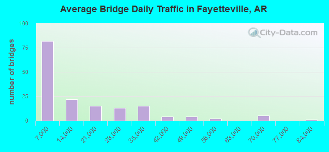
- 2,294,234Total average daily traffic
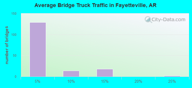
- 103,966Total average daily truck traffic
- National Bridge Inventory (NBI) Registered Bridges for Fayetteville
- No street view available for this location
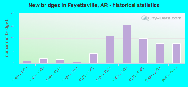
- New bridges - historical statistics
- 21920-1929
- 41930-1939
- 31940-1949
- 11950-1959
- 81960-1969
- 221970-1979
- 311980-1989
- 201990-1999
- 162000-2009
- 162010-2019
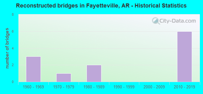
- Reconstructed bridges - Historical Statistics
- 31960-1969
- 11970-1979
- 21980-1989
- 01990-1999
- 02000-2009
- 62010-2019
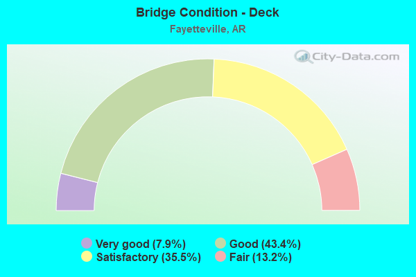
- Bridge Condition - Deck
- 7.9%Very good
- 43.4%Good
- 35.5%Satisfactory
- 13.2%Fair
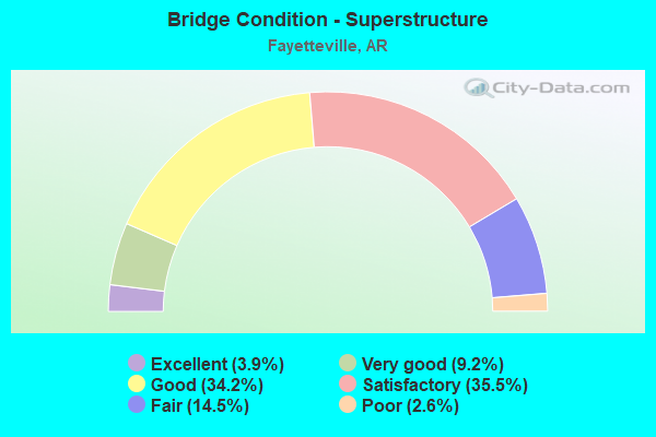
- Bridge Condition - Superstructure
- 3.9%Excellent
- 9.2%Very good
- 34.2%Good
- 35.5%Satisfactory
- 14.5%Fair
- 2.6%Poor
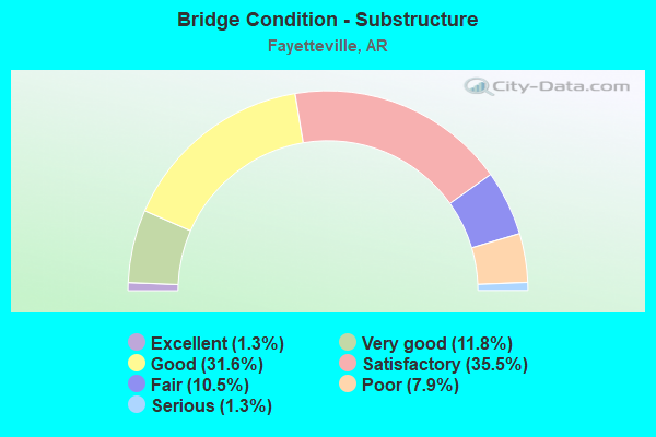
- Bridge Condition - Substructure
- 1.3%Excellent
- 11.8%Very good
- 31.6%Good
- 35.5%Satisfactory
- 10.5%Fair
- 7.9%Poor
- 1.3%Serious
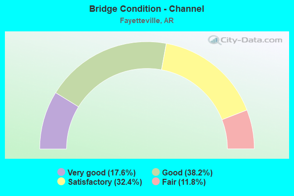
- Bridge Condition - Channel
- 17.6%Very good
- 38.2%Good
- 32.4%Satisfactory
- 11.8%Fair
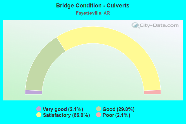
- Bridge Condition - Culverts
- 2.1%Very good
- 29.8%Good
- 66.0%Satisfactory
- 2.1%Poor
Find on map >> Show street view
Structure Number: 5628, Location: JCT I-49 & SH 16 IN CITY (Lat: 36.078269, Lng: -94.201050), Route carried "under" structure: Interstate 49, Structure Length: 0. m, Average Daily Traffic: 30,500 (year 2014), Truck Traffic: 1%, Features Intersected: I-49 MN LNS, Facility Carried by Structure: SH 16-Washington
Minimum Vertical Clearance: 5.07m (16.63ft), Kilometerpoint: 102.660, Length of Maximum Span: 0.0m
Find on map >> Show street view
Structure Number: 5692, Location: 4 MI N US 62 & 71 INTCH (Lat: 36.105331, Lng: -94.179631), Route carried "under" structure: Interstate 49, Structure Length: 0. m, Average Daily Traffic: 42,500 (year 2015), Truck Traffic: 1%, Features Intersected: I 49 MN LNS, Facility Carried by Structure: SH 112-Wash. Co.
Minimum Vertical Clearance: 6.85m (22.47ft), Kilometerpoint: 106.217, Length of Maximum Span: 0.0m
Find on map >> Show street view
Structure Number: 5692, Location: 4 MI N US 62 & 71 INTCH (Lat: 36.105331, Lng: -94.179631), Route carried "under" structure: Interstate 49, Structure Length: 0. m, Average Daily Traffic: 42,500 (year 2015), Truck Traffic: 1%, Features Intersected: I 49 MN LNS, Facility Carried by Structure: SH 112-Wash. Co.
Minimum Vertical Clearance: 6.30m (20.67ft), Kilometerpoint: 106.233, Length of Maximum Span: 0.0m
Find on map >> Show street view
Structure Number: 5692, Location: 4 MI N US 62 & 71 INTCH (Lat: 36.105331, Lng: -94.179631), Route carried "under" structure: Ramp Interstate 49, Structure Length: 0. m, Average Daily Traffic: 42,500 (year 2015), Truck Traffic: 1%, Features Intersected: I49/Hwy 112 Off Ramp, Facility Carried by Structure: SH 112-Wash. Co.
Minimum Vertical Clearance: 5.66m (18.57ft), Kilometerpoint: 106.233, Length of Maximum Span: 0.0m
Find on map >> Show street view
Structure Number: 5819, Location: 0.07 SO JCT US71/I540 (Lat: 36.035739, Lng: -94.186600), Route carried "under" structure: US 71, Structure Length: 0. m, Average Daily Traffic: 2,400 (year 2014), Truck Traffic: 1%, Features Intersected: US 71, Sec 16, Facility Carried by Structure: SH 265-Wash Co.
Minimum Vertical Clearance: 5.15m (16.90ft), Kilometerpoint: 37.522, Length of Maximum Span: 0.0m
Find on map >> Show street view
Structure Number: 5819, Location: 0.07 SO JCT US71/I540 (Lat: 36.035739, Lng: -94.186600), Route carried "under" structure: US 71, Structure Length: 0. m, Average Daily Traffic: 2,400 (year 2014), Truck Traffic: 1%, Features Intersected: US 71, Sec 16, Facility Carried by Structure: SH 265-Wash Co.
Minimum Vertical Clearance: 5.66m (18.57ft), Kilometerpoint: 37.522, Length of Maximum Span: 0.0m
Find on map >> Show street view
Structure Number: 582, Location: INTSEC US 62 & I-49 (Lat: 36.053639, Lng: -94.194619), Route carried "under" structure: US 62, Structure Length: 0. m, Average Daily Traffic: 33,000 (year 2013), Truck Traffic: 1%, Features Intersected: US 62-SEC 1, Facility Carried by Structure: I-49, SB LNS
Minimum Vertical Clearance: 5.02m (16.47ft), Kilometerpoint: 39.815, Length of Maximum Span: 0.0m
Find on map >> Show street view
Structure Number: 5916, Location: I49 & US 71B (Lat: 36.109069, Lng: -94.169689), Route carried "under" structure: Business US 71, Structure Length: 0. m, Average Daily Traffic: 25,000 (year 2016), Truck Traffic: 3%, Features Intersected: US 71B Mn Lns, Facility Carried by Structure: I49 NB MN LN RAMP
Minimum Vertical Clearance: 5.18m (16.99ft), Kilometerpoint: 0.644, Length of Maximum Span: 0.0m
Find on map >> Show street view
Structure Number: 5916, Location: I49 & US 71B (Lat: 36.109069, Lng: -94.169689), Route carried "under" structure: Business US 71, Structure Length: 0. m, Average Daily Traffic: 25,000 (year 2016), Truck Traffic: 3%, Features Intersected: US 71B Mn Lns, Facility Carried by Structure: I49 NB MN LN RAMP
Minimum Vertical Clearance: 5.25m (17.22ft), Kilometerpoint: 0.644, Length of Maximum Span: 0.0m
Find on map >> Show street view
Structure Number: 5917, Location: JCT I-49 & US 71B 17B (Lat: 36.108611, Lng: -94.174550), Route carried "under" structure: Interstate 49, Structure Length: 0. m, Average Daily Traffic: 64,000 (year 2014), Truck Traffic: 1%, Features Intersected: I-49 SB - Hwy 112 Ramp
Minimum Vertical Clearance: 5.30m (17.39ft), Kilometerpoint: 107.295, Length of Maximum Span: 0.0m
Find on map >> Show street view
Structure Number: 5917, Location: JCT I-49 & US 71B 17B (Lat: 36.108611, Lng: -94.174550), Route carried "under" structure: Business US 71, Structure Length: 0. m, Average Daily Traffic: 51,000 (year 2014), Truck Traffic: 1%, Features Intersected: 71B SB to Hwy 112 Ramp, Facility Carried by Structure: I-49 NE RAMP
Minimum Vertical Clearance: 4.99m (16.37ft), Kilometerpoint: 0.225, Length of Maximum Span: 0.0m
Find on map >> Show street view
Structure Number: 5917, Location: JCT I-49 & US 71B 17B (Lat: 36.108611, Lng: -94.174550), Route carried "under" structure: Ramp US 71, Structure Length: 0. m, Average Daily Traffic: 64,000 (year 2014), Truck Traffic: 1%, Features Intersected: 71B 17B SB to I-49 SB, Facility Carried by Structure: I-49 NE RAMP
Minimum Vertical Clearance: 5.09m (16.70ft), Kilometerpoint: 0.225, Length of Maximum Span: 0.0m
Find on map >> Show street view
Structure Number: 5921, Location: 4.6 MI N Jct 71B-17B (Lat: 36.160950, Lng: -94.187111), Route carried "under" structure: Interstate 49, Structure Length: 0. m, Average Daily Traffic: 33,000 (year 2014), Truck Traffic: 11%, Features Intersected: I-49, Facility Carried by Structure: Watkins Avenue
Minimum Vertical Clearance: 5.12m (16.80ft), Kilometerpoint: 113.507, Length of Maximum Span: 0.0m
Find on map >> Show street view
Structure Number: 5921, Location: 4.6 MI N Jct 71B-17B (Lat: 36.160950, Lng: -94.187111), Route carried "under" structure: Interstate 49, Structure Length: 0. m, Average Daily Traffic: 33,000 (year 2014), Truck Traffic: 11%, Features Intersected: I-49, Facility Carried by Structure: Watkins Avenue
Minimum Vertical Clearance: 5.43m (17.81ft), Kilometerpoint: 113.507, Length of Maximum Span: 0.0m
Find on map >> Show street view
Structure Number: 5945, Location: 1.3 MI N INT I-49 &US412 (Lat: 36.193300, Lng: -94.180350), Route carried "under" structure: Interstate 49, Structure Length: 0. m, Average Daily Traffic: 39,000 (year 2014), Truck Traffic: 1%, Features Intersected: I-49, Facility Carried by Structure: Elm Springs Road
Minimum Vertical Clearance: 5.15m (16.90ft), Kilometerpoint: 117.337, Length of Maximum Span: 0.0m
Find on map >> Show street view
Structure Number: 5945, Location: 1.3 MI N INT I-49 &US412 (Lat: 36.193300, Lng: -94.180350), Route carried "under" structure: Interstate 49, Structure Length: 0. m, Average Daily Traffic: 39,000 (year 2014), Truck Traffic: 1%, Features Intersected: I-49, Facility Carried by Structure: Elm Springs Road
Minimum Vertical Clearance: 5.10m (16.73ft), Kilometerpoint: 117.337, Length of Maximum Span: 0.0m
Find on map >> Show street view
Structure Number: 6244, Location: JCT OF I 49 ML & 71 SB (Lat: 36.037031, Lng: -94.188689), Route carried "under" structure: Interstate 49, Structure Length: 0. m, Average Daily Traffic: 16,000 (year 2013), Truck Traffic: 1%, Features Intersected: I 49 Mn Lns
Minimum Vertical Clearance: 5.51m (18.08ft), Kilometerpoint: 97.768, Length of Maximum Span: 0.0m
Find on map >> Show street view
Structure Number: 6244, Location: JCT OF I 49 ML & 71 SB (Lat: 36.037031, Lng: -94.188689), Route carried "under" structure: Interstate 49, Structure Length: 0. m, Average Daily Traffic: 16,000 (year 2013), Truck Traffic: 1%, Features Intersected: I 49 Mn Lns
Minimum Vertical Clearance: 6.76m (22.18ft), Kilometerpoint: 97.768, Length of Maximum Span: 0.0m
Find on map >> Show street view
Structure Number: 6323, Location: 1.24 MI E JCT I540 (Lat: 36.056611, Lng: -94.171972), Route carried "under" structure: State highway 180, Structure Length: 0. m, Average Daily Traffic: 7,400 (year 2014), Truck Traffic: 1%, Features Intersected: SH 180 SEC 0, Facility Carried by Structure: AR-MO RR
Minimum Vertical Clearance: 5.38m (17.65ft), Kilometerpoint: 2.092, Length of Maximum Span: 0.0m
Find on map >> Show street view
Structure Number: 7254, Location: Hwy 71B - Jct Sec 16B&17B (Lat: 36.116875, Lng: -94.144989), Route carried "under" structure: Business US 71, Structure Length: 0. m, Average Daily Traffic: 6,000 (year 2014), Truck Traffic: 1%, Features Intersected: Hwy 71B 16B & 17B
Minimum Vertical Clearance: 10.61m (34.81ft), Kilometerpoint: 2.688, Length of Maximum Span: 0.0m
Find on map >> Show street view
Structure Number: 7254, Location: Hwy 71B - Jct Sec 16B&17B (Lat: 36.116875, Lng: -94.144989), Route carried "under" structure: US 71, Structure Length: 0. m, Average Daily Traffic: 32,000 (year 2013), Truck Traffic: 1%, Features Intersected: Hwy 71B 16B & 17B
Minimum Vertical Clearance: 5.33m (17.49ft), Kilometerpoint: 2.543, Length of Maximum Span: 0.0m
Find on map >> Show street view
Structure Number: 7254, Location: Hwy 71B - Jct Sec 16B&17B (Lat: 36.116875, Lng: -94.144989), Route carried "under" structure: Business US 71, Structure Length: 0. m, Average Daily Traffic: 16,000 (year 2014), Truck Traffic: 1%, Features Intersected: Hwy 71B 16B & 17B
Minimum Vertical Clearance: 5.30m (17.39ft), Kilometerpoint: 10.763, Length of Maximum Span: 0.0m
Find on map >> Show street view
Structure Number: 7287, Location: 2.69 NO JCT 49 & 62 (Lat: 36.089669, Lng: -94.193369), Route carried "under" structure: City street 46260, Structure Length: 0. m, Average Daily Traffic: 700 (year 1983), Truck Traffic: 1%, Features Intersected: Porter Road, Facility Carried by Structure: I-49, SB LNS
Minimum Vertical Clearance: 5.76m (18.90ft), Kilometerpoint: 0.002, Length of Maximum Span: 0.0m
Find on map >> Show street view
Structure Number: 7379, Location: SH112/I-49/71B Intchg (Lat: 36.106469, Lng: -94.172539), Route carried "under" structure: Ramp Interstate 49, Structure Length: 0. m, Average Daily Traffic: 78,000 (year 2017), Truck Traffic: 12%, Features Intersected: I-49 Ramp to 71B
Minimum Vertical Clearance: 5.39m (17.68ft), Kilometerpoint: 107.359, Length of Maximum Span: 0.0m
Find on map >> Show street view
Structure Number: 19534, Location: 0.53MI W 71-B (Lat: 36.062917, Lng: -94.167658), Route carried "under" structure: City street 10050, Structure Length: 0. m, Average Daily Traffic: 3,453 (year 1983), Truck Traffic: 1%, Features Intersected: Center Street, Facility Carried by Structure: Frisco Street RR
Minimum Vertical Clearance: 4.16m (13.65ft), Kilometerpoint: 0.853, Length of Maximum Span: 0.0m
Find on map >> Show street view
Structure Number: 20821, Location: 0.8 MI N SH 112 & 180 JCT (Lat: 36.068139, Lng: -94.180056), Route carried "under" structure: City street 112, Structure Length: 0. m, Average Daily Traffic: 16,000 (year 2013), Truck Traffic: 1%, Features Intersected: SH 112/RAZORBACK DR., Facility Carried by Structure: Ped Bridge (U OF A
Minimum Vertical Clearance: 4.49m (14.73ft), Kilometerpoint: 0.546, Length of Maximum Span: 0.0m
Find on map >> Show street view
Structure Number: A5802, Location: 5.21 NO JCT US 62 & 71 (Lat: 36.111450, Lng: -94.164081), Route carried "under" structure: City street 23760, Structure Length: 0. m, Average Daily Traffic: 30,800 (year 2004), Truck Traffic: 1%, Features Intersected: GREGG AVE, RR, Facility Carried by Structure: US 71-SEC 17B, SB
Minimum Vertical Clearance: 7.23m (23.72ft), Kilometerpoint: 0.002, Length of Maximum Span: 0.0m
Find on map >> Show street view
Structure Number: A592, Location: 2.35 N INTER I-49 & 71B (Lat: 36.138331, Lng: -94.182950), Route carried "under" structure: County highway 54, Structure Length: 0. m, Average Daily Traffic: 85 (year 1987), Truck Traffic: 1%, Features Intersected: CR54-E(GR. HOUSE SP. RD), Facility Carried by Structure: I-49 SB LNS - Wash
Minimum Vertical Clearance: 4.90m (16.08ft), Kilometerpoint: 3.701, Length of Maximum Span: 0.0m
Find on map >> Show street view
Structure Number: A6243, Location: JCT I 49 & SH 265 (Lat: 36.033331, Lng: -94.188200), Route carried "under" structure: State highway 265, Structure Length: 0. m, Average Daily Traffic: 6,800 (year 2014), Truck Traffic: 1%, Features Intersected: SH 265-1, Facility Carried by Structure: I-49 SB LNS
Minimum Vertical Clearance: 5.35m (17.55ft), Kilometerpoint: 31.398, Length of Maximum Span: 0.0m
Find on map >> Show street view
Structure Number: A738, Location: I-49 & US 71B (Lat: 36.109061, Lng: -94.170381), Route carried "under" structure: Business US 71, Structure Length: 0. m, Average Daily Traffic: 25,000 (year 2016), Truck Traffic: 12%, Features Intersected: US 71B MN LN, Facility Carried by Structure: I-49 SB MN LN Ramp
Minimum Vertical Clearance: 5.35m (17.55ft), Kilometerpoint: 0.644, Length of Maximum Span: 0.0m
Find on map >> Show street view
Structure Number: A738, Location: I-49 & US 71B (Lat: 36.109061, Lng: -94.170381), Route carried "under" structure: Business US 71, Structure Length: 0. m, Average Daily Traffic: 25,000 (year 2016), Truck Traffic: 12%, Features Intersected: US 71 MN LN, Facility Carried by Structure: I-49 SB MN LN Ramp
Minimum Vertical Clearance: 4.90m (16.08ft), Kilometerpoint: 0.644, Length of Maximum Span: 0.0m
Find on map >> Show street view
Structure Number: B5802, Location: 5.21 NO JCT US 62 & 71 (Lat: 36.111150, Lng: -94.164069), Route carried "under" structure: City street 23760, Structure Length: 0. m, Average Daily Traffic: 30,800 (year 2004), Truck Traffic: 1%, Features Intersected: GREGG AVE, RR, Facility Carried by Structure: US 71-SEC 17B, NB
Minimum Vertical Clearance: 7.28m (23.88ft), Kilometerpoint: 0.002, Length of Maximum Span: 0.0m
Find on map >> Show street view
Structure Number: B592, Location: 2.35 N INTER I-49 & 71B (Lat: 36.138219, Lng: -94.182611), Route carried "under" structure: City street 54, Structure Length: 0. m, Average Daily Traffic: 100 (year 1985), Truck Traffic: 1%, Features Intersected: Johnson Mill Blvd., Facility Carried by Structure: I-49 North Bound
Minimum Vertical Clearance: 5.83m (19.13ft), Kilometerpoint: 1.996, Length of Maximum Span: 0.0m
Find on map >> Show street view
Structure Number: B6243, Location: JCT I 49& SH 265 (Lat: 36.033531, Lng: -94.188031), Route carried "under" structure: State highway 265, Structure Length: 0. m, Average Daily Traffic: 6,800 (year 2014), Truck Traffic: 1%, Features Intersected: SH 265, Facility Carried by Structure: Interstate 49 NB
Minimum Vertical Clearance: 5.36m (17.59ft), Kilometerpoint: 31.414, Length of Maximum Span: 0.0m
Find on map >> Show street view
Structure Number: B738, Location: I-49 & US 71B (Lat: 36.108950, Lng: -94.170031), Route carried "under" structure: Business US 71, Structure Length: 0. m, Average Daily Traffic: 25,000 (year 2016), Truck Traffic: 12%, Features Intersected: US 71B MNLN, Facility Carried by Structure: I-49 NB MN LN Ramp
Minimum Vertical Clearance: 6.18m (20.28ft), Kilometerpoint: 0.644, Length of Maximum Span: 0.0m
Find on map >> Show street view
Structure Number: B738, Location: I-49 & US 71B (Lat: 36.108950, Lng: -94.170031), Route carried "under" structure: Business US 71, Structure Length: 0. m, Average Daily Traffic: 25,000 (year 2016), Truck Traffic: 12%, Features Intersected: US 71MNLN, Facility Carried by Structure: I-49 NB MN LN Ramp
Minimum Vertical Clearance: 6.22m (20.41ft), Kilometerpoint: 0.644, Length of Maximum Span: 0.0m
Find on map >> Show street view
Structure Number: M4096, Location: 300' S. of Maple St. (Lat: 36.069694, Lng: -94.170000), Route carried "under" structure: State lands road 873, Structure Length: 0. m, Average Daily Traffic: 652 (year 1990), Truck Traffic: 1%, Features Intersected: SH 873, Facility Carried by Structure: U A GRAD ED BLDG
Minimum Vertical Clearance: 2.80m (9.19ft), Kilometerpoint: 0.002, Length of Maximum Span: 0.0m