Bridge Statistics for Fort Payne, Alabama (AL)
Condition, Traffic, Stress, Structural Evaluation, Project Costs
- National Bridge Inventory (NBI) Statistics
- 89Number of bridges
- 856ft / 261mTotal length
- $111,751,000Total costs
- 566,975Total average daily traffic
- 109,915Total average daily truck traffic
- National Bridge Inventory (NBI) Registered Bridges for Fort Payne
- No street view available for this location
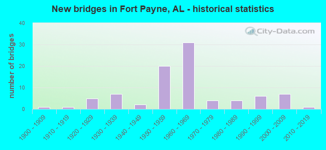
- New bridges - historical statistics
- 11900-1909
- 11910-1919
- 51920-1929
- 71930-1939
- 21940-1949
- 201950-1959
- 311960-1969
- 41970-1979
- 41980-1989
- 61990-1999
- 72000-2009
- 12010-2019

- Reconstructed bridges - Historical Statistics
- 11930-1939
- 01940-1949
- 01950-1959
- 01960-1969
- 01970-1979
- 21980-1989
- 01990-1999
- 12000-2009


- Bridge Condition - Deck
- 2.8%Excellent
- 5.6%Very good
- 27.8%Good
- 36.1%Satisfactory
- 22.2%Fair
- 5.6%Poor

- Bridge Condition - Superstructure
- 2.8%Excellent
- 13.9%Very good
- 33.3%Good
- 27.8%Satisfactory
- 16.7%Fair
- 2.8%Poor
- 2.8%Serious

- Bridge Condition - Substructure
- 2.8%Excellent
- 5.6%Very good
- 44.4%Good
- 25.0%Satisfactory
- 16.7%Fair
- 2.8%Poor
- 2.8%Serious

- Bridge Condition - Channel
- 5.3%Very good
- 28.9%Good
- 52.6%Satisfactory
- 13.2%Fair

- Bridge Condition - Culverts
- 4.3%Very good
- 34.8%Good
- 52.2%Satisfactory
- 8.7%Fair
Find on map >> Show street view
Structure Number: 7196, Location: 200FT N CO RT 85 T6SR9E (Lat: 34.528139, Lng: -85.698858), Route carried "on" structure: County highway 749, Year Built: 1960, Status: Open, Structure Length: 0.63m (2.07ft), Average Daily Traffic: 124 (year 2021), Truck Traffic: 2%, Average Future Daily Traffic: 184 (year 2041), Design Load: H 15, Features Intersected: SMITH BRANCH
Minimum Vertical Clearance: 30+ m (98+ ft), Kilometerpoint: 0.010, Lanes on structure: 2, Owner: County Highway Agency, Approaching Roadway Width: 5.9m (19.4ft), Material/Design: Concrete, Design/Construction: Culvert, Number Of Spans In Main Unit: 2, Length of Maximum Span: 3.0m (9.8ft)
Condition: Channel: Satisfactory, Culverts: Good, Operating Rating: 40.0 metric tons, Method Used To Determine Operating Rating: Load Factor (LF), Inventory Rating: 23.9 metric tons, Method Used To Determine Inventory Rating: Load Factor (LF), Structural Evaluation: Equal to present minimum criteria, Waterway Adequacy: Better than present minimum criteria, Approach Roadway Alignment: Equal to present desirable criteria, Length Of Structure Improvement: 1.24m (4.07ft), Designated Inspection Frequency: Every 24 months, Inspection Date: May 2021, Bridge Improvement Cost: $151,000, Roadway Improvement Cost: $15,000, Total Project Cost: $166,000 ( Estimate for 2022)
Find on map >> Show street view
Structure Number: 7777, Location: 1MI N LEBANON T7SR8E (Lat: 34.375264, Lng: -85.813808), Route carried "on" structure: County highway 87, Year Built: 1962, Status: Open, Structure Length: 0.89m (2.92ft), Average Daily Traffic: 315 (year 2021), Truck Traffic: 4%, Average Future Daily Traffic: 468 (year 2041), Design Load: H 15, Features Intersected: TRIB. TO BIG WILLS CREEK, Facility Carried by Structure: CO RD 88
Minimum Vertical Clearance: 30+ m (98+ ft), Kilometerpoint: 0.010, Lanes on structure: 2, Owner: County Highway Agency, Approaching Roadway Width: 7.9m (25.9ft), Skew: 4 degrees, Material/Design: Concrete, Design/Construction: Culvert, Number Of Spans In Main Unit: 2, Length of Maximum Span: 3.0m (9.8ft)
Condition: Channel: Satisfactory, Culverts: Satisfactory, Operating Rating: 43.5 metric tons, Method Used To Determine Operating Rating: Load Factor (LF), Inventory Rating: 26.1 metric tons, Method Used To Determine Inventory Rating: Load Factor (LF), Structural Evaluation: Equal to present minimum criteria, Waterway Adequacy: Equal to present minimum criteria, Approach Roadway Alignment: Equal to present desirable criteria, Length Of Structure Improvement: 1.56m (5.12ft), Designated Inspection Frequency: Every 24 months, Inspection Date: May 2021, Bridge Improvement Cost: $404,000, Roadway Improvement Cost: $40,000, Total Project Cost: $444,000 ( Estimate for 2022)
Find on map >> Show street view
Structure Number: 8148, Location: 10 MI N JCT I59 * SR 68 (Lat: 34.393175, Lng: -85.788236), Route carried "on" structure: Interstate 59, Year Built: 1964, Status: Open, Structure Length: 1.65m (5.41ft), Average Daily Traffic: 19,076 (year 2018), Truck Traffic: 34%, Average Future Daily Traffic: 26,706 (year 2038), Design Load: HS 20, Features Intersected: VALLEY BRANCH
Minimum Vertical Clearance: 30+ m (98+ ft), Kilometerpoint: 345.814, Lanes on structure: 2, Base Highway Network: Yes, Owner: State Highway Agency, Approaching Roadway Width: 7.3m (24.0ft), Skew: 13 degrees, Material/Design: Concrete, Design/Construction: Culvert, Number Of Spans In Main Unit: 4, Length of Maximum Span: 3.7m (12.1ft)
Condition: Channel: Satisfactory, Culverts: Satisfactory, Operating Rating: 88.9 metric tons, Method Used To Determine Operating Rating: Load Factor (LF), Inventory Rating: 88.9 metric tons, Method Used To Determine Inventory Rating: Load Factor (LF), Structural Evaluation: Equal to present minimum criteria, Waterway Adequacy: Equal to present minimum criteria, Approach Roadway Alignment: Equal to present desirable criteria, Length Of Structure Improvement: 2.33m (7.64ft), Designated Inspection Frequency: Every 24 months, Inspection Date: May 2020, Bridge Improvement Cost: $1,537,000, Roadway Improvement Cost: $154,000, Total Project Cost: $1,691,000 ( Estimate for 2022)
Find on map >> Show street view
Structure Number: 8149, Location: 10 MI N JCT I59 * SR 68 (Lat: 34.393161, Lng: -85.787339), Route carried "on" structure: Interstate 59, Year Built: 1964, Status: Open, Structure Length: 1.65m (5.41ft), Average Daily Traffic: 19,076 (year 2018), Truck Traffic: 34%, Average Future Daily Traffic: 26,706 (year 2038), Design Load: HS 20, Features Intersected: VALLEY BRANCH
Minimum Vertical Clearance: 30+ m (98+ ft), Kilometerpoint: 345.814, Lanes on structure: 2, Base Highway Network: Yes, Owner: State Highway Agency, Approaching Roadway Width: 7.3m (24.0ft), Skew: 13 degrees, Material/Design: Concrete, Design/Construction: Culvert, Number Of Spans In Main Unit: 4, Length of Maximum Span: 3.7m (12.1ft)
Condition: Channel: Satisfactory, Culverts: Satisfactory, Operating Rating: 88.9 metric tons, Method Used To Determine Operating Rating: Load Factor (LF), Inventory Rating: 88.9 metric tons, Method Used To Determine Inventory Rating: Load Factor (LF), Structural Evaluation: Equal to present minimum criteria, Waterway Adequacy: Equal to present minimum criteria, Approach Roadway Alignment: Equal to present desirable criteria, Length Of Structure Improvement: 2.33m (7.64ft), Designated Inspection Frequency: Every 24 months, Inspection Date: May 2020, Bridge Improvement Cost: $1,079,000, Roadway Improvement Cost: $108,000, Total Project Cost: $1,187,000 ( Estimate for 2022)
Find on map >> Show street view
Structure Number: 815, Location: 2 MI S JCT I59 * SR 35 (Lat: 34.415350, Lng: -85.771797), Route carried "on" structure: Interstate 59, Year Built: 1964, Status: Open, Structure Length: 1.31m (4.30ft), Average Daily Traffic: 19,076 (year 2018), Truck Traffic: 34%, Average Future Daily Traffic: 26,706 (year 2038), Design Load: HS 20, Features Intersected: BRANCH
Minimum Vertical Clearance: 30+ m (98+ ft), Kilometerpoint: 348.610, Lanes on structure: 4, Base Highway Network: Yes, Owner: State Highway Agency, Approaching Roadway Width: 14.6m (47.9ft), Skew: 13 degrees, Material/Design: Concrete, Design/Construction: Culvert, Number Of Spans In Main Unit: 3, Length of Maximum Span: 3.7m (12.1ft)
Condition: Channel: Good, Culverts: Fair, Operating Rating: 88.9 metric tons, Method Used To Determine Operating Rating: Load Factor (LF), Inventory Rating: 88.9 metric tons, Method Used To Determine Inventory Rating: Load Factor (LF), Structural Evaluation: Somewhat better than minimum adequacy, Waterway Adequacy: Equal to present desirable criteria, Approach Roadway Alignment: Equal to present desirable criteria, Length Of Structure Improvement: 1.98m (6.50ft), Designated Inspection Frequency: Every 24 months, Inspection Date: March 2020, Bridge Improvement Cost: $2,590,000, Roadway Improvement Cost: $259,000, Total Project Cost: $2,849,000 ( Estimate for 2022)
Find on map >> Show street view
Structure Number: 8151, Location: CO RT 51 OVP MP 216.8 (Lat: 34.417108, Lng: -85.769781), Route carried "on" structure: County highway 51, Year Built: 1964, Status: Open, Structure Length: 9.45m (31.00ft), Average Daily Traffic: 1,450 (year 2020), Truck Traffic: 2%, Average Future Daily Traffic: 2,030 (year 2040), Design Load: H 20, Features Intersected: I-59
Minimum Vertical Clearance: 30+ m (98+ ft), Kilometerpoint: 0.000, Lanes on structure: 2, Lanes under structure: 4, Owner: State Highway Agency, Approaching Roadway Width: 11.0m (36.1ft), Skew: 3 degrees, Material/Design: Concrete continuous, Design/Construction: Tee Beam, Number Of Spans In Main Unit: 4, Length of Maximum Span: 25.9m (85.0ft), Curb or Sidewalk Widths: Left: 0.5m (1.6ft), Right: 0.5m (1.6ft), Curb-To-Curb Width: 7.3m (24.0ft), Out-to-Out Width: 8.8m (28.9ft)
Condition: Deck: Good, Superstructure: Good, Substructure: Good, Operating Rating: 57.4 metric tons, Method Used To Determine Operating Rating: Load Factor (LF), Inventory Rating: 34.4 metric tons, Method Used To Determine Inventory Rating: Load Factor (LF), Structural Evaluation: Better than present minimum criteria, Deck Geometry: Meets minimum limits, Underclear: Somewhat better than minimum adequacy, Approach Roadway Alignment: Equal to present minimum criteria, Length Of Structure Improvement: 10.40m (34.12ft), Designated Inspection Frequency: Every 24 months, Inspection Date: March 2022, Bridge Improvement Cost: $1,997,000, Roadway Improvement Cost: $200,000, Total Project Cost: $2,197,000 ( Estimate for 2022), Deck Structure Type: Concrete Cast-file-Place
Find on map >> Show street view
Structure Number: 841, Location: 0.1 MI N LEBANON T8SR8E (Lat: 34.369156, Lng: -85.815508), Route carried "on" structure: County highway 87, Year Built: 1964, Status: Open, Structure Length: 0.62m (2.03ft), Average Daily Traffic: 324 (year 2022), Truck Traffic: 5%, Average Future Daily Traffic: 481 (year 2042), Design Load: H 15, Features Intersected: HORTON BRANCH, Facility Carried by Structure: CO RD 88
Minimum Vertical Clearance: 30+ m (98+ ft), Kilometerpoint: 0.010, Lanes on structure: 2, Owner: County Highway Agency, Approaching Roadway Width: 7.9m (25.9ft), Material/Design: Concrete, Design/Construction: Culvert, Number Of Spans In Main Unit: 2, Length of Maximum Span: 3.0m (9.8ft)
Condition: Channel: Satisfactory, Culverts: Satisfactory, Operating Rating: 40.6 metric tons, Method Used To Determine Operating Rating: Load Factor (LF), Inventory Rating: 24.3 metric tons, Method Used To Determine Inventory Rating: Load Factor (LF), Structural Evaluation: Equal to present minimum criteria, Waterway Adequacy: Better than present minimum criteria, Approach Roadway Alignment: Equal to present desirable criteria, Length Of Structure Improvement: 1.24m (4.07ft), Designated Inspection Frequency: Every 24 months, Inspection Date: Febuary 2022, Bridge Improvement Cost: $230,000, Roadway Improvement Cost: $23,000, Total Project Cost: $253,000 ( Estimate for 2022)
Find on map >> Show street view
Structure Number: 8436, Location: .3 MI N JCT AL 176 T8SR9E (Lat: 34.343944, Lng: -85.698039), Route carried "on" structure: County highway 127, Year Built: 1964, Status: Open, Structure Length: 0.63m (2.07ft), Average Daily Traffic: 348 (year 2021), Truck Traffic: 4%, Average Future Daily Traffic: 517 (year 2041), Design Load: H 15, Features Intersected: TRIB. TO LITTER RIVER
Minimum Vertical Clearance: 30+ m (98+ ft), Kilometerpoint: 0.010, Lanes on structure: 2, Owner: County Highway Agency, Approaching Roadway Width: 10.7m (35.1ft), Material/Design: Concrete, Design/Construction: Culvert, Number Of Spans In Main Unit: 2, Length of Maximum Span: 3.0m (9.8ft)
Condition: Channel: Satisfactory, Culverts: Satisfactory, Operating Rating: 43.0 metric tons, Method Used To Determine Operating Rating: Load Factor (LF), Inventory Rating: 25.8 metric tons, Method Used To Determine Inventory Rating: Load Factor (LF), Structural Evaluation: Equal to present minimum criteria, Waterway Adequacy: Equal to present minimum criteria, Approach Roadway Alignment: Equal to present minimum criteria, Length Of Structure Improvement: 1.25m (4.10ft), Designated Inspection Frequency: Every 24 months, Inspection Date: July 2021, Bridge Improvement Cost: $260,000, Roadway Improvement Cost: $26,000, Total Project Cost: $286,000 ( Estimate for 2022)
Find on map >> Show street view
Structure Number: 8891, Location: .8MI NE DESOTO PARKT6SR10 (Lat: 34.508561, Lng: -85.608653), Route carried "on" structure: County highway 165, Year Built: 1965, Status: Posted for load, Structure Length: 3.90m (12.80ft), Average Daily Traffic: 477 (year 2020), Truck Traffic: 7%, Average Future Daily Traffic: 709 (year 2040), Design Load: H 15, Features Intersected: WEST FORK LITTLE RIVER
Minimum Vertical Clearance: 30+ m (98+ ft), Kilometerpoint: 0.010, Lanes on structure: 2, Owner: County Highway Agency, Approaching Roadway Width: 6.7m (22.0ft), Material/Design: Steel continuous, Design/Construction: Stringer/Multi-beam, Number Of Spans In Main Unit: 4, Length of Maximum Span: 19.5m (64.0ft), Curb-To-Curb Width: 6.7m (22.0ft), Out-to-Out Width: 7.2m (23.6ft)
Condition: Deck: Good, Superstructure: Good, Substructure: Good, Channel: Good, Operating Rating: 20.0 metric tons, Method Used To Determine Operating Rating: Load Factor (LF), Inventory Rating: 10.6 metric tons, Method Used To Determine Inventory Rating: Load Factor (LF), Structural Evaluation: High priority of replacement, Deck Geometry: Meets minimum limits, Waterway Adequacy: Better than present minimum criteria, Approach Roadway Alignment: Equal to present minimum criteria, Bridge Posting: Required (Relationship of Operating Rating to Maximum Legal Load: > 39.9% below), Length Of Structure Improvement: 4.85m (15.91ft), Designated Inspection Frequency: Every 24 months, Underwater Inspection Frequency: Every 48 months, Other Special Inspection Frequency: Every 12 months, Inspection Date: November 2020, Underwater Inspection Date: June 2019, Other Special Inspection Date: November 2021, Bridge Improvement Cost: $764,000, Roadway Improvement Cost: $76,000, Total Project Cost: $840,000 ( Estimate for 2022), Deck Structure Type: Concrete Cast-file-Place
Find on map >> Show street view
Structure Number: 932, Location: JCT US11*SR35 (Lat: 34.431875, Lng: -85.731103), Route carried "on" structure: US 11, Year Built: 1967, Status: Open, Structure Length: 2.01m (6.59ft), Average Daily Traffic: 16,069 (year 2018), Truck Traffic: 5%, Average Future Daily Traffic: 22,497 (year 2038), Design Load: H 20, Features Intersected: LINE CREEK
Minimum Vertical Clearance: 30+ m (98+ ft), Kilometerpoint: 365.955, Lanes on structure: 2, Base Highway Network: Yes, Owner: State Highway Agency, Approaching Roadway Width: 7.3m (24.0ft), Skew: 1 degrees, Material/Design: Concrete, Design/Construction: Culvert, Number Of Spans In Main Unit: 5, Length of Maximum Span: 3.7m (12.1ft)
Condition: Channel: Satisfactory, Culverts: Satisfactory, Operating Rating: 50.0 metric tons, Method Used To Determine Operating Rating: Load Factor (LF), Inventory Rating: 29.9 metric tons, Method Used To Determine Inventory Rating: Load Factor (LF), Structural Evaluation: Equal to present minimum criteria, Waterway Adequacy: Equal to present minimum criteria, Approach Roadway Alignment: Better than present minimum criteria, Length Of Structure Improvement: 2.76m (9.06ft), Designated Inspection Frequency: Every 24 months, Inspection Date: April 2020, Bridge Improvement Cost: $1,164,000, Roadway Improvement Cost: $116,000, Total Project Cost: $1,280,000 ( Estimate for 2022), Wearing Surface/Protective System: Wearing Surface: Bituminous
Find on map >> Show street view
Structure Number: 9383, Location: 0.2 MI S OF 8TH ST (Lat: 34.431569, Lng: -85.728239), Route carried "on" structure: City street , Year Built: 1967, Status: Open, Structure Length: 0.91m (2.99ft), Average Daily Traffic: 4,900 (year 2022), Truck Traffic: 30%, Average Future Daily Traffic: 6,200 (year 2038), Design Load: H 15, Features Intersected: BRANCH, Facility Carried by Structure: GODFREY AVE
Minimum Vertical Clearance: 30+ m (98+ ft), Kilometerpoint: 0.010, Lanes on structure: 2, Owner: City or Municipal Highway Agency, Approaching Roadway Width: 6.7m (22.0ft), Material/Design: Concrete, Design/Construction: Culvert, Number Of Spans In Main Unit: 2, Length of Maximum Span: 3.7m (12.1ft), Curb or Sidewalk Widths: Left: 0.3m (1.0ft), Right: 0.3m (1.0ft), Curb-To-Curb Width: 6.0m (19.7ft), Out-to-Out Width: 6.6m (21.7ft)
Condition: Channel: Satisfactory, Culverts: Fair, Operating Rating: 43.5 metric tons, Method Used To Determine Operating Rating: Field evaluation and documented engineering judgment, Inventory Rating: 32.7 metric tons, Method Used To Determine Inventory Rating: Field evaluation and documented engineering judgment, Structural Evaluation: Somewhat better than minimum adequacy, Deck Geometry: High priority of replacement, Waterway Adequacy: Equal to present minimum criteria, Approach Roadway Alignment: Equal to present minimum criteria, Length Of Structure Improvement: 1.58m (5.18ft), Designated Inspection Frequency: Every 24 months, Inspection Date: March 2022, Bridge Improvement Cost: $192,000, Roadway Improvement Cost: $19,000, Total Project Cost: $211,000 ( Estimate for 2022), Wearing Surface/Protective System: Wearing Surface: Bituminous
Find on map >> Show street view
Structure Number: 9395, Location: 0.8 MI S OF AIRPORT (Lat: 34.466794, Lng: -85.729136), Route carried "on" structure: City street , Year Built: 1967, Status: Open, Structure Length: 1.58m (5.18ft), Average Daily Traffic: 1,700 (year 2019), Truck Traffic: 40%, Average Future Daily Traffic: 2,300 (year 2034), Design Load: H 15, Features Intersected: BRANCH, Facility Carried by Structure: AIRPORT AVE
Minimum Vertical Clearance: 7.56m (24.80ft), Kilometerpoint: 0.010, Lanes on structure: 2, Owner: City or Municipal Highway Agency, Approaching Roadway Width: 7.6m (24.9ft), Skew: 3 degrees, Material/Design: Concrete, Design/Construction: Culvert, Number Of Spans In Main Unit: 3, Length of Maximum Span: 3.7m (12.1ft), Curb-To-Curb Width: 8.5m (27.9ft), Out-to-Out Width: 9.5m (31.2ft)
Condition: Channel: Good, Culverts: Good, Operating Rating: 49.2 metric tons, Method Used To Determine Operating Rating: Load Factor (LF), Inventory Rating: 29.5 metric tons, Method Used To Determine Inventory Rating: Load Factor (LF), Structural Evaluation: Better than present minimum criteria, Deck Geometry: Somewhat better than minimum adequacy, Approach Roadway Alignment: Equal to present desirable criteria, Length Of Structure Improvement: 2.26m (7.41ft), Designated Inspection Frequency: Every 24 months, Inspection Date: April 2021, Bridge Improvement Cost: $470,000, Roadway Improvement Cost: $47,000, Total Project Cost: $517,000 ( Estimate for 2022), Wearing Surface/Protective System: Wearing Surface: Bituminous
Find on map >> Show street view
Structure Number: 97, Location: IN CITY OF FT PAYNE (Lat: 34.436667, Lng: -85.741667), Route carried "on" structure: State highway 35, Year Built: 1968, Status: Open, Structure Length: 2.01m (6.59ft), Average Daily Traffic: 15,986 (year 2019), Truck Traffic: 5%, Average Future Daily Traffic: 22,380 (year 2039), Design Load: H 20, Features Intersected: BRANCH
Minimum Vertical Clearance: 30+ m (98+ ft), Kilometerpoint: 37.084, Lanes on structure: 4, Base Highway Network: Yes, Owner: State Highway Agency, Approaching Roadway Width: 16.8m (55.1ft), Skew: 2 degrees, Material/Design: Concrete, Design/Construction: Culvert, Number Of Spans In Main Unit: 5, Length of Maximum Span: 3.7m (12.1ft)
Condition: Channel: Good, Culverts: Good, Operating Rating: 51.8 metric tons, Method Used To Determine Operating Rating: Load Factor (LF), Inventory Rating: 31.0 metric tons, Method Used To Determine Inventory Rating: Load Factor (LF), Structural Evaluation: Better than present minimum criteria, Waterway Adequacy: Better than present minimum criteria, Approach Roadway Alignment: Equal to present minimum criteria, Length Of Structure Improvement: 2.76m (9.06ft), Designated Inspection Frequency: Every 24 months, Inspection Date: Febuary 2021, Bridge Improvement Cost: $1,227,000, Roadway Improvement Cost: $123,000, Total Project Cost: $1,350,000 ( Estimate for 2022), Wearing Surface/Protective System: Wearing Surface: Bituminous
Find on map >> Show street view
Structure Number: 9701, Location: IN CITY OF FORT PAYNE (Lat: 34.436819, Lng: -85.743439), Route carried "on" structure: State highway 35, Year Built: 1968, Status: Open, Structure Length: 2.16m (7.09ft), Average Daily Traffic: 21,098 (year 2020), Truck Traffic: 6%, Average Future Daily Traffic: 29,537 (year 2040), Design Load: H 20, Features Intersected: BRANCH
Minimum Vertical Clearance: 30+ m (98+ ft), Kilometerpoint: 38.195, Lanes on structure: 5, Base Highway Network: Yes, Owner: State Highway Agency, Approaching Roadway Width: 18.3m (60.0ft), Skew: 4 degrees, Material/Design: Concrete, Design/Construction: Culvert, Number Of Spans In Main Unit: 4, Length of Maximum Span: 3.7m (12.1ft)
Condition: Channel: Satisfactory, Culverts: Satisfactory, Operating Rating: 57.9 metric tons, Method Used To Determine Operating Rating: Load Factor (LF), Inventory Rating: 34.7 metric tons, Method Used To Determine Inventory Rating: Load Factor (LF), Structural Evaluation: Equal to present minimum criteria, Waterway Adequacy: Better than present minimum criteria, Approach Roadway Alignment: Equal to present desirable criteria, Length Of Structure Improvement: 2.95m (9.68ft), Designated Inspection Frequency: Every 24 months, Inspection Date: Febuary 2022, Bridge Improvement Cost: $1,893,000, Roadway Improvement Cost: $189,000, Total Project Cost: $2,082,000 ( Estimate for 2022), Wearing Surface/Protective System: Wearing Surface: Bituminous
Find on map >> Show street view
Structure Number: 982, Location: 1 MI N CO RT 88 T7SR8E (Lat: 34.385194, Lng: -85.819361), Route carried "on" structure: Spur County highway 31S, Year Built: 1968, Status: Posted for load, Structure Length: 0.67m (2.20ft), Average Daily Traffic: 89 (year 2021), Average Future Daily Traffic: 132 (year 2041), Design Load: H 10, Features Intersected: BRANCH, Facility Carried by Structure: CO RT 290
Minimum Vertical Clearance: 30+ m (98+ ft), Kilometerpoint: 0.010, Lanes on structure: 1, Owner: County Highway Agency, Approaching Roadway Width: 4.3m (14.1ft), Material/Design: Steel, Design/Construction: Stringer/Multi-beam, Number Of Spans In Main Unit: 1, Length of Maximum Span: 6.7m (22.0ft), Curb-To-Curb Width: 3.4m (11.2ft), Out-to-Out Width: 3.7m (12.1ft)
Condition: Deck: Fair, Superstructure: Fair, Substructure: Satisfactory, Channel: Satisfactory, Operating Rating: 22.3 metric tons, Method Used To Determine Operating Rating: Load Factor (LF), Inventory Rating: 15.4 metric tons, Method Used To Determine Inventory Rating: Load Factor (LF), Structural Evaluation: Meets minimum limits, Deck Geometry: High priority of corrective action, Waterway Adequacy: Somewhat better than minimum adequacy, Approach Roadway Alignment: Meets minimum limits, Bridge Posting: Required (Relationship of Operating Rating to Maximum Legal Load: > 39.9% below), Length Of Structure Improvement: 1.30m (4.27ft), Designated Inspection Frequency: Every 24 months, Other Special Inspection Frequency: Every 12 months, Inspection Date: July 2021, Other Special Inspection Date: July 2021, Bridge Improvement Cost: $107,000, Roadway Improvement Cost: $11,000, Total Project Cost: $118,000 ( Estimate for 2022), Deck Structure Type: Wood or Timber, Wearing Surface/Protective System: Wearing Surface: Wood or Timber
Find on map >> Show street view
Structure Number: 10055, Location: BETWEEN GODFREY * SANDERS (Lat: 34.438236, Lng: -85.722439), Route carried "on" structure: City street , Year Built: 1969, Status: Open, Structure Length: 1.19m (3.90ft), Average Daily Traffic: 475 (year 2020), Truck Traffic: 3%, Average Future Daily Traffic: 540 (year 2036), Design Load: H 15, Features Intersected: BRANCH, Facility Carried by Structure: 3RD ST SE
Minimum Vertical Clearance: 7.56m (24.80ft), Kilometerpoint: 0.010, Lanes on structure: 2, Owner: City or Municipal Highway Agency, Approaching Roadway Width: 13.1m (43.0ft), Skew: 1 degrees, Material/Design: Concrete, Design/Construction: Culvert, Number Of Spans In Main Unit: 3, Length of Maximum Span: 4.0m (13.1ft), Curb-To-Curb Width: 12.6m (41.3ft), Out-to-Out Width: 13.1m (43.0ft)
Condition: Channel: Satisfactory, Culverts: Good, Operating Rating: 51.8 metric tons, Method Used To Determine Operating Rating: Load Factor (LF), Inventory Rating: 31.0 metric tons, Method Used To Determine Inventory Rating: Load Factor (LF), Structural Evaluation: Better than present minimum criteria, Deck Geometry: Superior to present desirable criteria, Waterway Adequacy: Somewhat better than minimum adequacy, Approach Roadway Alignment: Equal to present minimum criteria, Length Of Structure Improvement: 1.86m (6.10ft), Designated Inspection Frequency: Every 24 months, Inspection Date: Febuary 2022, Bridge Improvement Cost: $376,000, Roadway Improvement Cost: $38,000, Total Project Cost: $414,000 ( Estimate for 2022), Wearing Surface/Protective System: Wearing Surface: Bituminous
Find on map >> Show street view
Structure Number: 10057, Location: SANDERS AND LOGAN (Lat: 34.438783, Lng: -85.721875), Route carried "on" structure: City street , Year Built: 1969, Status: Open, Structure Length: 0.85m (2.79ft), Average Daily Traffic: 330 (year 2020), Truck Traffic: 1%, Average Future Daily Traffic: 440 (year 2036), Design Load: H 15, Features Intersected: BRANCH, Facility Carried by Structure: LOGAN ST
Minimum Vertical Clearance: 7.56m (24.80ft), Kilometerpoint: 0.010, Lanes on structure: 2, Owner: City or Municipal Highway Agency, Approaching Roadway Width: 6.7m (22.0ft), Material/Design: Concrete, Design/Construction: Culvert, Number Of Spans In Main Unit: 2, Length of Maximum Span: 4.0m (13.1ft), Curb-To-Curb Width: 6.7m (22.0ft), Out-to-Out Width: 7.3m (24.0ft)
Condition: Channel: Good, Culverts: Good, Operating Rating: 32.7 metric tons, Method Used To Determine Operating Rating: Field evaluation and documented engineering judgment, Inventory Rating: 23.6 metric tons, Method Used To Determine Inventory Rating: Field evaluation and documented engineering judgment, Structural Evaluation: Equal to present minimum criteria, Deck Geometry: Meets minimum limits, Waterway Adequacy: Superior to present desirable criteria, Approach Roadway Alignment: Equal to present minimum criteria, Length Of Structure Improvement: 1.51m (4.95ft), Designated Inspection Frequency: Every 24 months, Inspection Date: Febuary 2022, Bridge Improvement Cost: $210,000, Roadway Improvement Cost: $21,000, Total Project Cost: $231,000 ( Estimate for 2022), Wearing Surface/Protective System: Wearing Surface: Bituminous
Find on map >> Show street view
Structure Number: 1006, Location: BETWEEN SANDERS * GODFREY (Lat: 34.438333, Lng: -85.688333), Route carried "on" structure: City street , Year Built: 1969, Status: Open, Structure Length: 1.10m (3.61ft), Average Daily Traffic: 540 (year 2020), Truck Traffic: 3%, Average Future Daily Traffic: 685 (year 2036), Design Load: H 15, Features Intersected: BRANCH, Facility Carried by Structure: 1ST ST SE
Minimum Vertical Clearance: 7.56m (24.80ft), Kilometerpoint: 0.010, Lanes on structure: 2, Owner: City or Municipal Highway Agency, Approaching Roadway Width: 11.0m (36.1ft), Material/Design: Concrete, Design/Construction: Culvert, Number Of Spans In Main Unit: 3, Length of Maximum Span: 3.7m (12.1ft), Curb or Sidewalk Widths: Left: 1.4m (4.6ft), Right: 0.0m, Curb-To-Curb Width: 12.1m (39.7ft), Out-to-Out Width: 14.0m (45.9ft)
Condition: Channel: Good, Culverts: Good, Operating Rating: 47.5 metric tons, Method Used To Determine Operating Rating: Load Factor (LF), Inventory Rating: 28.5 metric tons, Method Used To Determine Inventory Rating: Load Factor (LF), Structural Evaluation: Better than present minimum criteria, Deck Geometry: Better than present minimum criteria, Waterway Adequacy: Equal to present minimum criteria, Approach Roadway Alignment: Equal to present minimum criteria, Length Of Structure Improvement: 1.77m (5.81ft), Designated Inspection Frequency: Every 24 months, Inspection Date: Febuary 2022, Bridge Improvement Cost: $369,000, Roadway Improvement Cost: $37,000, Total Project Cost: $406,000 ( Estimate for 2022)
Find on map >> Show street view
Structure Number: 10093, Location: 2.2 MI S CO RT 89 T7SR9E (Lat: 34.384797, Lng: -85.713953), Route carried "on" structure: County highway 127, Year Built: 1969, Status: Open, Structure Length: 0.63m (2.07ft), Average Daily Traffic: 779 (year 2021), Truck Traffic: 9%, Average Future Daily Traffic: 1,158 (year 2041), Design Load: H 15, Features Intersected: HICKS CREEK
Minimum Vertical Clearance: 30+ m (98+ ft), Kilometerpoint: 0.010, Lanes on structure: 2, Owner: County Highway Agency, Approaching Roadway Width: 7.9m (25.9ft), Material/Design: Concrete, Design/Construction: Culvert, Number Of Spans In Main Unit: 2, Length of Maximum Span: 3.0m (9.8ft)
Condition: Channel: Good, Culverts: Satisfactory, Operating Rating: 70.7 metric tons, Method Used To Determine Operating Rating: Load Factor (LF), Inventory Rating: 42.4 metric tons, Method Used To Determine Inventory Rating: Load Factor (LF), Structural Evaluation: Equal to present minimum criteria, Waterway Adequacy: Better than present minimum criteria, Approach Roadway Alignment: Equal to present minimum criteria, Length Of Structure Improvement: 1.24m (4.07ft), Designated Inspection Frequency: Every 24 months, Inspection Date: April 2021, Bridge Improvement Cost: $344,000, Roadway Improvement Cost: $34,000, Total Project Cost: $378,000 ( Estimate for 2022), Deck Structure Type: Concrete Cast-file-Place
Find on map >> Show street view
Structure Number: 10433, Location: 10 MI N JCT SR273 (Lat: 34.336328, Lng: -85.681836), Route carried "on" structure: County highway 275, Year Built: 1970, Status: Posted for load, Structure Length: 0.97m (3.18ft), Average Daily Traffic: 60 (year 2020), Average Future Daily Traffic: 100 (year 2040), Design Load: H 15, Features Intersected: CHINQUAPIN CREEK
Minimum Vertical Clearance: 30+ m (98+ ft), Kilometerpoint: 0.010, Lanes on structure: 2, Owner: County Highway Agency, Approaching Roadway Width: 7.3m (24.0ft), Skew: 2 degrees, Material/Design: Steel, Design/Construction: Stringer/Multi-beam, Number Of Spans In Main Unit: 1, Length of Maximum Span: 9.7m (31.8ft), Curb-To-Curb Width: 6.9m (22.6ft), Out-to-Out Width: 7.4m (24.3ft)
Condition: Deck: Satisfactory, Superstructure: Satisfactory, Substructure: Satisfactory, Channel: Good, Operating Rating: 33.9 metric tons, Method Used To Determine Operating Rating: Load Factor (LF), Inventory Rating: 21.3 metric tons, Method Used To Determine Inventory Rating: Load Factor (LF), Structural Evaluation: Equal to present minimum criteria, Deck Geometry: Somewhat better than minimum adequacy, Waterway Adequacy: Equal to present desirable criteria, Approach Roadway Alignment: Meets minimum limits, Bridge Posting: Required (Relationship of Operating Rating to Maximum Legal Load: 0.1 - 9.9% below), Length Of Structure Improvement: 1.64m (5.38ft), Designated Inspection Frequency: Every 24 months, Other Special Inspection Frequency: Every 12 months, Inspection Date: July 2021, Other Special Inspection Date: July 2021, Bridge Improvement Cost: $270,000, Roadway Improvement Cost: $27,000, Total Project Cost: $297,000 ( Estimate for 2022), Deck Structure Type: Concrete Cast-file-Place
Find on map >> Show street view
Structure Number: 11458, Location: 0.75 MI E OF US 11 (Lat: 34.516667, Lng: -85.683333), Route carried "on" structure: City street , Year Built: 1975, Status: Open, Structure Length: 2.07m (6.79ft), Average Daily Traffic: 1,200 (year 2018), Truck Traffic: 5%, Average Future Daily Traffic: 1,300 (year 2033), Design Load: H 15, Features Intersected: BIG WILLS CREEK, Facility Carried by Structure: 67TH ST NW
Minimum Vertical Clearance: 30+ m (98+ ft), Kilometerpoint: 0.010, Lanes on structure: 2, Owner: City or Municipal Highway Agency, Approaching Roadway Width: 7.3m (24.0ft), Material/Design: Concrete, Design/Construction: Channel Beam, Number Of Spans In Main Unit: 2, Length of Maximum Span: 10.4m (34.1ft), Curb or Sidewalk Widths: Left: 0.3m (1.0ft), Right: 0.3m (1.0ft), Curb-To-Curb Width: 7.3m (24.0ft), Out-to-Out Width: 8.0m (26.2ft)
Condition: Deck: Satisfactory, Superstructure: Good, Substructure: Fair, Channel: Satisfactory, Operating Rating: 44.3 metric tons, Method Used To Determine Operating Rating: Allowable Stress (AS), Inventory Rating: 26.6 metric tons, Method Used To Determine Inventory Rating: Allowable Stress (AS), Structural Evaluation: Somewhat better than minimum adequacy, Deck Geometry: Meets minimum limits, Waterway Adequacy: Equal to present minimum criteria, Approach Roadway Alignment: High priority of corrective action, Length Of Structure Improvement: 2.84m (9.32ft), Designated Inspection Frequency: Every 24 months, Underwater Inspection Frequency: Every 48 months, Inspection Date: Febuary 2022, Underwater Inspection Date: Febuary 2020, Bridge Improvement Cost: $506,000, Roadway Improvement Cost: $51,000, Total Project Cost: $557,000 ( Estimate for 2022), Deck Structure Type: Concrete Precast Panels, Wearing Surface/Protective System: Wearing Surface: Bituminous
Find on map >> Show street view
Structure Number: 1146, Location: 300 FT N OF SR 35 (Lat: 34.448333, Lng: -85.755000), Route carried "on" structure: City street , Year Built: 1975, Status: Open, Structure Length: 3.11m (10.20ft), Average Daily Traffic: 335 (year 2020), Truck Traffic: 2%, Average Future Daily Traffic: 460 (year 2036), Design Load: H 15, Features Intersected: BIG WILLS CREEK, Facility Carried by Structure: BROOKWOOD DR
Minimum Vertical Clearance: 30+ m (98+ ft), Kilometerpoint: 0.010, Lanes on structure: 2, Owner: City or Municipal Highway Agency, Approaching Roadway Width: 8.2m (26.9ft), Material/Design: Concrete, Design/Construction: Channel Beam, Number Of Spans In Main Unit: 3, Length of Maximum Span: 10.4m (34.1ft), Curb or Sidewalk Widths: Left: 0.2m (0.7ft), Right: 0.2m (0.7ft), Curb-To-Curb Width: 7.6m (24.9ft), Out-to-Out Width: 8.2m (26.9ft)
Condition: Deck: Satisfactory, Superstructure: Good, Substructure: Satisfactory, Channel: Good, Operating Rating: 51.5 metric tons, Method Used To Determine Operating Rating: Load Factor (LF), Inventory Rating: 30.8 metric tons, Method Used To Determine Inventory Rating: Load Factor (LF), Structural Evaluation: Equal to present minimum criteria, Deck Geometry: Somewhat better than minimum adequacy, Waterway Adequacy: Equal to present minimum criteria, Approach Roadway Alignment: High priority of corrective action, Length Of Structure Improvement: 3.96m (12.99ft), Designated Inspection Frequency: Every 24 months, Inspection Date: Febuary 2022, Bridge Improvement Cost: $706,000, Roadway Improvement Cost: $71,000, Total Project Cost: $777,000 ( Estimate for 2022), Deck Structure Type: Concrete Precast Panels
Find on map >> Show street view
Structure Number: 11842, Location: 1.2 MI E CO RT 127T7SR9E (Lat: 34.380886, Lng: -85.697978), Route carried "on" structure: County highway 77, Year Built: 1977, Status: Posted for load, Structure Length: 2.04m (6.69ft), Average Daily Traffic: 213 (year 2021), Truck Traffic: 4%, Average Future Daily Traffic: 317 (year 2041), Design Load: H 15, Features Intersected: BEAR CREEK, Facility Carried by Structure: CO RT 270
Minimum Vertical Clearance: 30+ m (98+ ft), Kilometerpoint: 0.010, Lanes on structure: 2, Owner: County Highway Agency, Approaching Roadway Width: 6.1m (20.0ft), Material/Design: Concrete, Design/Construction: Channel Beam, Number Of Spans In Main Unit: 3, Length of Maximum Span: 7.3m (24.0ft), Curb-To-Curb Width: 7.2m (23.6ft), Out-to-Out Width: 7.7m (25.3ft)
Condition: Deck: Satisfactory, Superstructure: Satisfactory, Substructure: Fair, Channel: Very good, Operating Rating: 36.9 metric tons, Method Used To Determine Operating Rating: Load Factor (LF), Inventory Rating: 22.1 metric tons, Method Used To Determine Inventory Rating: Load Factor (LF), Structural Evaluation: Somewhat better than minimum adequacy, Deck Geometry: Meets minimum limits, Waterway Adequacy: Superior to present desirable criteria, Approach Roadway Alignment: Somewhat better than minimum adequacy, Bridge Posting: Required (Relationship of Operating Rating to Maximum Legal Load: 0.1 - 9.9% below), Length Of Structure Improvement: 2.80m (9.19ft), Designated Inspection Frequency: Every 24 months, Other Special Inspection Frequency: Every 12 months, Inspection Date: December 2021, Other Special Inspection Date: December 2021, Bridge Improvement Cost: $481,000, Roadway Improvement Cost: $48,000, Total Project Cost: $529,000 ( Estimate for 2022), Deck Structure Type: Concrete Precast Panels, Wearing Surface/Protective System: Wearing Surface: Bituminous
Find on map >> Show street view
Structure Number: 12242, Location: 1.5 MI E AL 35 T7SR9E (Lat: 34.433333, Lng: -85.633333), Route carried "on" structure: County highway 80, Year Built: 1900, Year Reconstructed: 1980, Status: Open, Structure Length: 1.46m (4.79ft), Average Daily Traffic: 290 (year 2020), Truck Traffic: 2%, Average Future Daily Traffic: 360 (year 2036), Design Load: H 15, Features Intersected: YELLOW CREEK
Minimum Vertical Clearance: 30+ m (98+ ft), Kilometerpoint: 0.010, Lanes on structure: 2, Owner: City or Municipal Highway Agency, Approaching Roadway Width: 7.9m (25.9ft), Material/Design: Concrete, Design/Construction: Channel Beam, Number Of Spans In Main Unit: 2, Length of Maximum Span: 7.3m (24.0ft), Curb-To-Curb Width: 7.3m (24.0ft), Out-to-Out Width: 7.6m (24.9ft)
Condition: Deck: Good, Superstructure: Good, Substructure: Satisfactory, Channel: Good, Operating Rating: 48.0 metric tons, Method Used To Determine Operating Rating: Allowable Stress (AS), Inventory Rating: 28.9 metric tons, Method Used To Determine Inventory Rating: Allowable Stress (AS), Structural Evaluation: Equal to present minimum criteria, Deck Geometry: Somewhat better than minimum adequacy, Waterway Adequacy: Equal to present minimum criteria, Approach Roadway Alignment: Somewhat better than minimum adequacy, Length Of Structure Improvement: 2.14m (7.02ft), Designated Inspection Frequency: Every 24 months, Inspection Date: Febuary 2022, Bridge Improvement Cost: $352,000, Roadway Improvement Cost: $35,000, Total Project Cost: $387,000 ( Estimate for 2022), Deck Structure Type: Concrete Precast Panels, Wearing Surface/Protective System: Wearing Surface: Bituminous, Deck Protection: Internally Sealed
Find on map >> Show street view
Structure Number: 13668, Location: 300 FT WEST OF SR 35 (Lat: 34.439383, Lng: -85.755808), Route carried "on" structure: City street , Year Built: 1985, Status: Open, Structure Length: 4.94m (16.21ft), Average Daily Traffic: 3,400 (year 2020), Truck Traffic: 4%, Average Future Daily Traffic: 4,150 (year 2036), Design Load: HS 20, Features Intersected: WILLS CREEK, Facility Carried by Structure: ROUTE 71
Minimum Vertical Clearance: 7.56m (24.80ft), Kilometerpoint: 0.010, Lanes on structure: 3, Owner: City or Municipal Highway Agency, Approaching Roadway Width: 12.2m (40.0ft), Skew: 1 degrees, Material/Design: Prestressed concrete continuous, Design/Construction: Stringer/Multi-beam, Number Of Spans In Main Unit: 3, Length of Maximum Span: 16.5m (54.1ft), Curb or Sidewalk Widths: Left: 0.2m (0.7ft), Right: 0.2m (0.7ft), Curb-To-Curb Width: 9.0m (29.5ft), Out-to-Out Width: 10.1m (33.1ft)
Condition: Deck: Good, Superstructure: Very good, Substructure: Good, Channel: Good, Operating Rating: 43.5 metric tons, Method Used To Determine Operating Rating: Field evaluation and documented engineering judgment, Inventory Rating: 32.7 metric tons, Method Used To Determine Inventory Rating: Field evaluation and documented engineering judgment, Structural Evaluation: Better than present minimum criteria, Deck Geometry: High priority of replacement, Waterway Adequacy: Equal to present minimum criteria, Approach Roadway Alignment: Equal to present minimum criteria, Length Of Structure Improvement: 5.96m (19.55ft), Designated Inspection Frequency: Every 24 months, Inspection Date: Febuary 2022, Bridge Improvement Cost: $1,348,000, Roadway Improvement Cost: $135,000, Total Project Cost: $1,483,000 ( Estimate for 2022), Deck Structure Type: Concrete Cast-file-Place, Wearing Surface/Protective System: Deck Protection: Epoxy Coated Reinforcing
Find on map >> Show street view
Structure Number: 13692, Location: 3.7 MI E JCT CO RD 275 (Lat: 34.371667, Lng: -85.693333), Route carried "on" structure: State highway 176, Year Built: 1985, Status: Open, Structure Length: 1.01m (3.31ft), Average Daily Traffic: 208 (year 2019), Truck Traffic: 2%, Average Future Daily Traffic: 292 (year 2039), Design Load: HS 20, Features Intersected: BEAR CREEK
Minimum Vertical Clearance: 30+ m (98+ ft), Kilometerpoint: 27.148, Lanes on structure: 2, Owner: State Highway Agency, Approaching Roadway Width: 6.1m (20.0ft), Material/Design: Concrete, Design/Construction: Culvert, Number Of Spans In Main Unit: 2, Length of Maximum Span: 4.9m (16.1ft)
Condition: Channel: Satisfactory, Culverts: Good, Operating Rating: 88.9 metric tons, Method Used To Determine Operating Rating: Load Factor (LF), Inventory Rating: 88.9 metric tons, Method Used To Determine Inventory Rating: Load Factor (LF), Structural Evaluation: Better than present minimum criteria, Waterway Adequacy: Better than present minimum criteria, Approach Roadway Alignment: Better than present minimum criteria, Length Of Structure Improvement: 1.68m (5.51ft), Designated Inspection Frequency: Every 24 months, Inspection Date: Febuary 2021, Bridge Improvement Cost: $524,000, Roadway Improvement Cost: $52,000, Total Project Cost: $576,000 ( Estimate for 2022), Wearing Surface/Protective System: Wearing Surface: Bituminous
Find on map >> Show street view
Structure Number: 13964, Location: 0.5 MI W OF AIRPORT AVE (Lat: 34.468400, Lng: -85.733400), Route carried "on" structure: City street , Year Built: 1986, Status: Posted for load, Structure Length: 1.52m (4.99ft), Average Daily Traffic: 355 (year 2021), Truck Traffic: 2%, Average Future Daily Traffic: 420 (year 2037), Design Load: H 10, Features Intersected: BIG WILLS CREEK, Facility Carried by Structure: HOUSTON LOOP RD.
Minimum Vertical Clearance: 30+ m (98+ ft), Kilometerpoint: 0.010, Lanes on structure: 2, Owner: City or Municipal Highway Agency, Approaching Roadway Width: 6.1m (20.0ft), Material/Design: Steel, Design/Construction: Stringer/Multi-beam, Number Of Spans In Main Unit: 2, Length of Maximum Span: 15.2m (49.9ft), Curb or Sidewalk Widths: Left: 0.2m (0.7ft), Right: 0.2m (0.7ft), Curb-To-Curb Width: 6.1m (20.0ft), Out-to-Out Width: 6.5m (21.3ft)
Condition: Deck: Fair, Superstructure: Fair, Substructure: Fair, Channel: Fair, Operating Rating: 5.5 metric tons, Method Used To Determine Operating Rating: Allowable Stress (AS), Inventory Rating: 3.6 metric tons, Method Used To Determine Inventory Rating: Allowable Stress (AS), Structural Evaluation: High priority of replacement, Deck Geometry: Meets minimum limits, Waterway Adequacy: Meets minimum limits, Approach Roadway Alignment: High priority of corrective action, Bridge Posting: Required (Relationship of Operating Rating to Maximum Legal Load: > 39.9% below), Length Of Structure Improvement: 2.20m (7.22ft), Designated Inspection Frequency: Every 24 months, Underwater Inspection Frequency: Every 48 months, Other Special Inspection Frequency: Every 12 months, Inspection Date: April 2021, Underwater Inspection Date: April 2019, Other Special Inspection Date: April 2021, Bridge Improvement Cost: $317,000, Roadway Improvement Cost: $32,000, Total Project Cost: $349,000 ( Estimate for 2022), Deck Structure Type: Concrete Cast-file-Place
Find on map >> Show street view
Structure Number: 14613, Location: 50 FT. SOUTH OF SR 35 (Lat: 34.432167, Lng: -85.733508), Route carried "on" structure: City street , Year Built: 1988, Status: Open, Structure Length: 1.89m (6.20ft), Average Daily Traffic: 1,500 (year 2020), Truck Traffic: 4%, Average Future Daily Traffic: 1,800 (year 2036), Design Load: H 15, Features Intersected: DYE BRANCH, Facility Carried by Structure: ALA AVE.
Minimum Vertical Clearance: 30+ m (98+ ft), Kilometerpoint: 0.010, Lanes on structure: 2, Owner: City or Municipal Highway Agency, Approaching Roadway Width: 17.1m (56.1ft), Skew: 1 degrees, Material/Design: Concrete, Design/Construction: Culvert, Number Of Spans In Main Unit: 4, Length of Maximum Span: 4.3m (14.1ft)
Condition: Channel: Good, Culverts: Very good, Operating Rating: 60.5 metric tons, Method Used To Determine Operating Rating: Load Factor (LF), Inventory Rating: 36.2 metric tons, Method Used To Determine Inventory Rating: Load Factor (LF), Structural Evaluation: Equal to present desirable criteria, Waterway Adequacy: Equal to present minimum criteria, Approach Roadway Alignment: Better than present minimum criteria, Length Of Structure Improvement: 2.62m (8.60ft), Designated Inspection Frequency: Every 24 months, Inspection Date: Febuary 2022, Bridge Improvement Cost: $937,000, Roadway Improvement Cost: $94,000, Total Project Cost: $1,031,000 ( Estimate for 2022), Wearing Surface/Protective System: Wearing Surface: Bituminous
Find on map >> Show street view
Structure Number: 15193, Location: 2.3MI N JCT CO RT52T7SR8E (Lat: 34.393411, Lng: -85.789961), Route carried "on" structure: County highway 51, Year Built: 1990, Status: Open, Structure Length: 1.32m (4.33ft), Average Daily Traffic: 1,644 (year 2021), Truck Traffic: 11%, Average Future Daily Traffic: 2,443 (year 2041), Design Load: H 15, Features Intersected: LITTLE WILLS VALLEY BR.
Minimum Vertical Clearance: 30+ m (98+ ft), Kilometerpoint: 0.010, Lanes on structure: 2, Owner: County Highway Agency, Approaching Roadway Width: 11.9m (39.0ft), Skew: 1 degrees, Material/Design: Concrete, Design/Construction: Culvert, Number Of Spans In Main Unit: 4, Length of Maximum Span: 3.0m (9.8ft)
Condition: Channel: Satisfactory, Culverts: Good, Operating Rating: 54.3 metric tons, Method Used To Determine Operating Rating: Load Factor (LF), Inventory Rating: 32.6 metric tons, Method Used To Determine Inventory Rating: Load Factor (LF), Structural Evaluation: Better than present minimum criteria, Waterway Adequacy: Equal to present desirable criteria, Approach Roadway Alignment: Equal to present desirable criteria, Length Of Structure Improvement: 1.99m (6.53ft), Designated Inspection Frequency: Every 24 months, Inspection Date: April 2021, Bridge Improvement Cost: $528,000, Roadway Improvement Cost: $53,000, Total Project Cost: $581,000 ( Estimate for 2022)
Find on map >> Show street view
Structure Number: 15194, Location: 0.2MI S JCT I59 T7SR8E (Lat: 34.416039, Lng: -85.774839), Route carried "on" structure: County highway 51, Year Built: 1990, Status: Open, Structure Length: 1.47m (4.82ft), Average Daily Traffic: 1,644 (year 2021), Truck Traffic: 11%, Average Future Daily Traffic: 2,443 (year 2041), Design Load: H 15, Features Intersected: TRIB. TO BIG WILLS CREEK
Minimum Vertical Clearance: 30+ m (98+ ft), Kilometerpoint: 0.010, Lanes on structure: 2, Owner: County Highway Agency, Approaching Roadway Width: 10.7m (35.1ft), Skew: 3 degrees, Material/Design: Concrete, Design/Construction: Culvert, Number Of Spans In Main Unit: 4, Length of Maximum Span: 3.0m (9.8ft)
Condition: Channel: Fair, Culverts: Good, Operating Rating: 57.1 metric tons, Method Used To Determine Operating Rating: Load Factor (LF), Inventory Rating: 34.2 metric tons, Method Used To Determine Inventory Rating: Load Factor (LF), Structural Evaluation: Better than present minimum criteria, Waterway Adequacy: Better than present minimum criteria, Approach Roadway Alignment: Equal to present desirable criteria, Length Of Structure Improvement: 2.15m (7.05ft), Designated Inspection Frequency: Every 24 months, Inspection Date: April 2021, Bridge Improvement Cost: $558,000, Roadway Improvement Cost: $56,000, Total Project Cost: $614,000 ( Estimate for 2022)
Find on map >> Show street view
Structure Number: 1574, Location: 1 MI N JCT I-59 * SR 35 (Lat: 34.438725, Lng: -85.766519), Route carried "on" structure: State highway 35, Year Built: 1992, Status: Open, Structure Length: 10.15m (33.30ft), Average Daily Traffic: 17,577 (year 2019), Truck Traffic: 7%, Average Future Daily Traffic: 24,608 (year 2039), Design Load: HS 20, Features Intersected: BIG WILLS CREEK
Minimum Vertical Clearance: 30+ m (98+ ft), Kilometerpoint: 40.589, Lanes on structure: 3, Owner: State Highway Agency, Approaching Roadway Width: 16.8m (55.1ft), Skew: 10 degrees, Material/Design: Prestressed concrete continuous, Design/Construction: Stringer/Multi-beam, Number Of Spans In Main Unit: 8, Length of Maximum Span: 12.8m (42.0ft), Curb-To-Curb Width: 15.8m (51.8ft), Out-to-Out Width: 16.6m (54.5ft)
Condition: Deck: Good, Superstructure: Good, Substructure: Good, Channel: Satisfactory, Operating Rating: 57.6 metric tons, Method Used To Determine Operating Rating: Load Factor (LF), Inventory Rating: 32.1 metric tons, Method Used To Determine Inventory Rating: Load Factor (LF), Structural Evaluation: Better than present minimum criteria, Deck Geometry: Better than present minimum criteria, Waterway Adequacy: Equal to present desirable criteria, Approach Roadway Alignment: Equal to present desirable criteria, Length Of Structure Improvement: 11.07m (36.32ft), Designated Inspection Frequency: Every 24 months, Inspection Date: April 2021, Bridge Improvement Cost: $4,100,000, Roadway Improvement Cost: $410,000, Total Project Cost: $4,510,000 ( Estimate for 2022), Deck Structure Type: Concrete Cast-file-Place
Find on map >> Show street view
Structure Number: 15741, Location: 1 MI N JCT I-59 * SR 35 (Lat: 34.438586, Lng: -85.767617), Route carried "on" structure: State highway 35, Year Built: 1992, Status: Open, Structure Length: 10.15m (33.30ft), Average Daily Traffic: 17,577 (year 2019), Truck Traffic: 7%, Average Future Daily Traffic: 24,608 (year 2039), Design Load: HS 20, Features Intersected: BIG WILLS CREEK
Minimum Vertical Clearance: 30+ m (98+ ft), Kilometerpoint: 40.589, Lanes on structure: 3, Owner: State Highway Agency, Approaching Roadway Width: 16.8m (55.1ft), Skew: 10 degrees, Material/Design: Prestressed concrete continuous, Design/Construction: Stringer/Multi-beam, Number Of Spans In Main Unit: 8, Length of Maximum Span: 12.8m (42.0ft), Curb-To-Curb Width: 15.8m (51.8ft), Out-to-Out Width: 16.6m (54.5ft)
Condition: Deck: Good, Superstructure: Good, Substructure: Good, Channel: Satisfactory, Operating Rating: 57.6 metric tons, Method Used To Determine Operating Rating: Load Factor (LF), Inventory Rating: 32.1 metric tons, Method Used To Determine Inventory Rating: Load Factor (LF), Structural Evaluation: Better than present minimum criteria, Deck Geometry: Better than present minimum criteria, Waterway Adequacy: Equal to present desirable criteria, Approach Roadway Alignment: Equal to present desirable criteria, Length Of Structure Improvement: 11.07m (36.32ft), Designated Inspection Frequency: Every 24 months, Inspection Date: April 2021, Bridge Improvement Cost: $4,100,000, Roadway Improvement Cost: $410,000, Total Project Cost: $4,510,000 ( Estimate for 2022), Deck Structure Type: Concrete Cast-file-Place
Find on map >> Show street view
Structure Number: 16164, Location: 0.5 MI E OF US 11 (Lat: 34.405703, Lng: -85.856144), Route carried "on" structure: City street , Year Built: 1994, Status: Open, Structure Length: 1.46m (4.79ft), Average Daily Traffic: 390 (year 2020), Truck Traffic: 3%, Average Future Daily Traffic: 490 (year 2036), Design Load: HS 20, Features Intersected: BIG WILLS CREEK, Facility Carried by Structure: BIG WILLS ROAD
Minimum Vertical Clearance: 30+ m (98+ ft), Kilometerpoint: 0.010, Lanes on structure: 2, Owner: City or Municipal Highway Agency, Approaching Roadway Width: 5.5m (18.0ft), Material/Design: Concrete, Design/Construction: Channel Beam, Number Of Spans In Main Unit: 2, Length of Maximum Span: 7.3m (24.0ft), Curb-To-Curb Width: 7.3m (24.0ft), Out-to-Out Width: 8.2m (26.9ft)
Condition: Deck: Good, Superstructure: Very good, Substructure: Good, Channel: Good, Operating Rating: 69.2 metric tons, Method Used To Determine Operating Rating: Load Factor (LF), Inventory Rating: 41.5 metric tons, Method Used To Determine Inventory Rating: Load Factor (LF), Structural Evaluation: Better than present minimum criteria, Deck Geometry: Somewhat better than minimum adequacy, Waterway Adequacy: Equal to present minimum criteria, Approach Roadway Alignment: High priority of replacement, Length Of Structure Improvement: 2.14m (7.02ft), Designated Inspection Frequency: Every 24 months, Inspection Date: Febuary 2022, Bridge Improvement Cost: $381,000, Roadway Improvement Cost: $38,000, Total Project Cost: $419,000 ( Estimate for 2022), Deck Structure Type: Concrete Precast Panels
Find on map >> Show street view
Structure Number: 17825, Location: .3 M E AL 35 T7S R9E (Lat: 34.403081, Lng: -85.636903), Route carried "on" structure: County highway 78, Year Built: 1999, Status: Open, Structure Length: 2.13m (6.99ft), Average Daily Traffic: 144 (year 2021), Truck Traffic: 3%, Average Future Daily Traffic: 214 (year 2041), Design Load: HS 20, Features Intersected: YELLOW CREEK, Facility Carried by Structure: COUNTY ROAD #295
Minimum Vertical Clearance: 30.18m (99.02ft), Kilometerpoint: 0.010, Lanes on structure: 1, Owner: County Highway Agency, Approaching Roadway Width: 4.3m (14.1ft), Material/Design: Steel continuous, Design/Construction: Stringer/Multi-beam, Number Of Spans In Main Unit: 2, Length of Maximum Span: 10.7m (35.1ft), Curb-To-Curb Width: 3.7m (12.1ft), Out-to-Out Width: 3.8m (12.5ft)
Condition: Deck: Very good, Superstructure: Good, Substructure: Good, Channel: Good, Operating Rating: 88.9 metric tons, Method Used To Determine Operating Rating: Load Factor (LF), Inventory Rating: 64.5 metric tons, Method Used To Determine Inventory Rating: Load Factor (LF), Structural Evaluation: Better than present minimum criteria, Deck Geometry: High priority of replacement, Waterway Adequacy: Better than present minimum criteria, Approach Roadway Alignment: Equal to present minimum criteria, Length Of Structure Improvement: 2.92m (9.58ft), Designated Inspection Frequency: Every 24 months, Inspection Date: June 2021, Bridge Improvement Cost: $240,000, Roadway Improvement Cost: $24,000, Total Project Cost: $264,000 ( Estimate for 2022), Deck Structure Type: Concrete Cast-file-Place
Find on map >> Show street view
Structure Number: 18336, Location: Dekalb &Cherokee Co line (Lat: 34.396083, Lng: -85.627278), Route carried "on" structure: State highway 35, Year Built: 2010, Status: Open, Structure Length: 14.17m (46.49ft), Average Daily Traffic: 3,648 (year 2018), Truck Traffic: 8%, Average Future Daily Traffic: 5,107 (year 2038), Design Load: HS 20, Features Intersected: LITTLE RIVER CANYON
Minimum Vertical Clearance: 30+ m (98+ ft), Kilometerpoint: 22.718, Lanes on structure: 2, Owner: State Highway Agency, Approaching Roadway Width: 15.2m (49.9ft), Material/Design: Steel, Design/Construction: Stringer/Multi-beam, Number Of Spans In Main Unit: 4, Length of Maximum Span: 41.1m (134.8ft), Curb or Sidewalk Widths: Left: 1.8m (5.9ft), Right: 0.0m, Curb-To-Curb Width: 15.2m (49.9ft), Out-to-Out Width: 16.2m (53.1ft)
Condition: Deck: Good, Superstructure: Very good, Substructure: Good, Channel: Very good, Operating Rating: 83.0 metric tons, Method Used To Determine Operating Rating: Load Factor (LF), Inventory Rating: 49.7 metric tons, Method Used To Determine Inventory Rating: Load Factor (LF), Structural Evaluation: Better than present minimum criteria, Deck Geometry: Superior to present desirable criteria, Waterway Adequacy: Equal to present desirable criteria, Approach Roadway Alignment: Equal to present desirable criteria, Length Of Structure Improvement: 14.97m (49.11ft), Designated Inspection Frequency: Every 24 months, Inspection Date: August 2020, Bridge Improvement Cost: $5,439,000, Roadway Improvement Cost: $544,000, Total Project Cost: $5,983,000 ( Estimate for 2022), Deck Structure Type: Concrete Cast-file-Place
Find on map >> Show street view
Structure Number: 18958, Location: .3.MIE.US11 (Lat: 34.535042, Lng: -85.659336), Route carried "on" structure: County highway 606, Year Built: 2003, Status: Open, Structure Length: 3.66m (12.01ft), Average Daily Traffic: 81 (year 2020), Truck Traffic: 3%, Average Future Daily Traffic: 120 (year 2040), Design Load: HS 20, Features Intersected: BIG WILLS CREEK
Minimum Vertical Clearance: 30+ m (98+ ft), Kilometerpoint: 0.483, Lanes on structure: 2, Owner: County Highway Agency, Approaching Roadway Width: 8.5m (27.9ft), Material/Design: Concrete, Design/Construction: Channel Beam, Number Of Spans In Main Unit: 3, Length of Maximum Span: 12.2m (40.0ft), Curb-To-Curb Width: 8.5m (27.9ft), Out-to-Out Width: 9.3m (30.5ft)
Condition: Deck: Very good, Superstructure: Very good, Substructure: Very good, Channel: Satisfactory, Operating Rating: 74.7 metric tons, Method Used To Determine Operating Rating: Load Factor (LF), Inventory Rating: 44.8 metric tons, Method Used To Determine Inventory Rating: Load Factor (LF), Structural Evaluation: Equal to present desirable criteria, Deck Geometry: Better than present minimum criteria, Waterway Adequacy: Superior to present desirable criteria, Approach Roadway Alignment: Equal to present desirable criteria, Length Of Structure Improvement: 4.58m (15.03ft), Designated Inspection Frequency: Every 24 months, Inspection Date: March 2020, Bridge Improvement Cost: $942,000, Roadway Improvement Cost: $94,000, Total Project Cost: $1,036,000 ( Estimate for 2022), Deck Structure Type: Concrete Precast Panels, Wearing Surface/Protective System: Wearing Surface: Bituminous
Find on map >> Show street view
Structure Number: 18964, Location: IN CITY OF FORT PAYNE (Lat: 34.470667, Lng: -85.702722), Route carried "on" structure: US 11, Year Built: 2007, Status: Open, Structure Length: 1.60m (5.25ft), Average Daily Traffic: 11,097 (year 2020), Truck Traffic: 5%, Average Future Daily Traffic: 15,536 (year 2040), Design Load: HS 20, Features Intersected: BRANCH
Minimum Vertical Clearance: 30+ m (98+ ft), Kilometerpoint: 371.404, Lanes on structure: 5, Base Highway Network: Yes, Owner: State Highway Agency, Approaching Roadway Width: 21.2m (69.6ft), Skew: 4 degrees, Material/Design: Concrete, Design/Construction: Culvert, Number Of Spans In Main Unit: 3, Length of Maximum Span: 5.3m (17.4ft), Curb-To-Curb Width: 19.4m (63.6ft), Out-to-Out Width: 42.3m (138.8ft)
Condition: Channel: Satisfactory, Culverts: Satisfactory, Operating Rating: 50.6 metric tons, Method Used To Determine Operating Rating: Load Factor (LF), Inventory Rating: 30.3 metric tons, Method Used To Determine Inventory Rating: Load Factor (LF), Structural Evaluation: Equal to present minimum criteria, Deck Geometry: Meets minimum limits, Waterway Adequacy: Better than present minimum criteria, Approach Roadway Alignment: Better than present minimum criteria, Length Of Structure Improvement: 2.29m (7.51ft), Designated Inspection Frequency: Every 24 months, Inspection Date: December 2021, Bridge Improvement Cost: $2,415,000, Roadway Improvement Cost: $242,000, Total Project Cost: $2,657,000 ( Estimate for 2022)
Find on map >> Show street view
Structure Number: 19429, Location: .4MI W. JCT US11 49TH ST. (Lat: 34.504722, Lng: -85.688611), Route carried "on" structure: City street 49, Year Built: 2009, Status: Open, Structure Length: 10.39m (34.09ft), Average Daily Traffic: 150 (year 2020), Average Future Daily Traffic: 255 (year 2040), Design Load: HS 20, Features Intersected: 49TH ST BIG WILLS CREEK
Minimum Vertical Clearance: 30+ m (98+ ft), Kilometerpoint: 0.644, Lanes on structure: 5, Owner: City or Municipal Highway Agency, Approaching Roadway Width: 23.2m (76.1ft), Material/Design: Prestressed concrete, Design/Construction: Stringer/Multi-beam, Number Of Spans In Main Unit: 4, Length of Maximum Span: 25.9m (85.0ft), Curb-To-Curb Width: 23.7m (77.8ft), Out-to-Out Width: 24.6m (80.7ft)
Condition: Deck: Excellent, Superstructure: Excellent, Substructure: Excellent, Channel: Very good, Operating Rating: 74.4 metric tons, Method Used To Determine Operating Rating: Load Factor (LF), Inventory Rating: 41.9 metric tons, Method Used To Determine Inventory Rating: Load Factor (LF), Structural Evaluation: Superior to present desirable criteria, Deck Geometry: Better than present minimum criteria, Waterway Adequacy: Equal to present desirable criteria, Approach Roadway Alignment: Equal to present desirable criteria, Length Of Structure Improvement: 11.31m (37.11ft), Designated Inspection Frequency: Every 24 months, Inspection Date: Febuary 2022, Bridge Improvement Cost: $6,203,000, Roadway Improvement Cost: $620,000, Total Project Cost: $6,823,000 ( Estimate for 2022), Deck Structure Type: Concrete Cast-file-Place
Find on map >> Show street view
Structure Number: 1943, Location: 1.2 MI E OF I59 (Lat: 34.494722, Lng: -85.676667), Route carried "on" structure: City street 49, Year Built: 2009, Status: Open, Structure Length: 1.28m (4.20ft), Average Daily Traffic: 200 (year 2021), Truck Traffic: 5%, Average Future Daily Traffic: 300 (year 2039), Design Load: HS 20, Features Intersected: BIG WILLS CREEK
Minimum Vertical Clearance: 30+ m (98+ ft), Kilometerpoint: 0.161, Lanes on structure: 6, Owner: City or Municipal Highway Agency, Approaching Roadway Width: 24.2m (79.4ft), Skew: 4 degrees, Material/Design: Concrete, Design/Construction: Culvert, Number Of Spans In Main Unit: 3, Length of Maximum Span: 4.2m (13.8ft), Curb-To-Curb Width: 46.3m (151.9ft), Out-to-Out Width: 46.9m (153.9ft)
Condition: Channel: Very good, Culverts: Very good, Operating Rating: 71.2 metric tons, Method Used To Determine Operating Rating: Load Factor (LF), Inventory Rating: 42.7 metric tons, Method Used To Determine Inventory Rating: Load Factor (LF), Structural Evaluation: Equal to present desirable criteria, Deck Geometry: Superior to present desirable criteria, Waterway Adequacy: Equal to present desirable criteria, Approach Roadway Alignment: Equal to present desirable criteria, Length Of Structure Improvement: 1.95m (6.40ft), Designated Inspection Frequency: Every 24 months, Inspection Date: Febuary 2021, Bridge Improvement Cost: $1,726,000, Roadway Improvement Cost: $173,000, Total Project Cost: $1,899,000 ( Estimate for 2022)
Find on map >> Show street view
Structure Number: 19473, Location: JCT I59 * US 11 (Lat: 34.477278, Lng: -85.711694), Route carried "on" structure: US 11, Year Built: 2006, Status: Open, Structure Length: 8.23m (27.00ft), Average Daily Traffic: 11,004 (year 2018), Truck Traffic: 5%, Average Future Daily Traffic: 15,406 (year 2038), Design Load: HS 20, Features Intersected: I-59
Minimum Vertical Clearance: 30+ m (98+ ft), Kilometerpoint: 372.565, Lanes on structure: 6, Lanes under structure: 4, Base Highway Network: Yes, Owner: State Highway Agency, Approaching Roadway Width: 27.3m (89.6ft), Skew: 1 degrees, Material/Design: Prestressed concrete continuous, Design/Construction: Stringer/Multi-beam, Number Of Spans In Main Unit: 2, Length of Maximum Span: 40.5m (132.9ft), Curb-To-Curb Width: 27.3m (89.6ft), Out-to-Out Width: 28.1m (92.2ft)
Condition: Deck: Good, Superstructure: Very good, Substructure: Very good, Operating Rating: 76.5 metric tons, Method Used To Determine Operating Rating: Load Factor (LF), Inventory Rating: 43.5 metric tons, Method Used To Determine Inventory Rating: Load Factor (LF), Structural Evaluation: Equal to present desirable criteria, Deck Geometry: Better than present minimum criteria, Underclear: Equal to present minimum criteria, Approach Roadway Alignment: Equal to present desirable criteria, Length Of Structure Improvement: 9.23m (30.28ft), Designated Inspection Frequency: Every 24 months, Inspection Date: August 2020, Bridge Improvement Cost: $5,822,000, Roadway Improvement Cost: $582,000, Total Project Cost: $6,404,000 ( Estimate for 2022), Deck Structure Type: Concrete Cast-file-Place