Bridge Statistics for Fort Payne, Alabama (AL)
Condition, Traffic, Stress, Structural Evaluation, Project Costs
- National Bridge Inventory (NBI) Statistics
- 89Number of bridges
- 856ft / 261mTotal length
- $111,751,000Total costs
- 566,975Total average daily traffic
- 109,915Total average daily truck traffic
- National Bridge Inventory (NBI) Registered Bridges for Fort Payne
- No street view available for this location
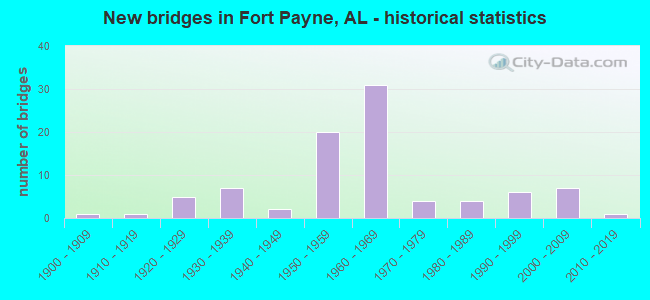
- New bridges - historical statistics
- 11900-1909
- 11910-1919
- 51920-1929
- 71930-1939
- 21940-1949
- 201950-1959
- 311960-1969
- 41970-1979
- 41980-1989
- 61990-1999
- 72000-2009
- 12010-2019

- Reconstructed bridges - Historical Statistics
- 11930-1939
- 01940-1949
- 01950-1959
- 01960-1969
- 01970-1979
- 21980-1989
- 01990-1999
- 12000-2009


- Bridge Condition - Deck
- 2.8%Excellent
- 5.6%Very good
- 27.8%Good
- 36.1%Satisfactory
- 22.2%Fair
- 5.6%Poor

- Bridge Condition - Superstructure
- 2.8%Excellent
- 13.9%Very good
- 33.3%Good
- 27.8%Satisfactory
- 16.7%Fair
- 2.8%Poor
- 2.8%Serious

- Bridge Condition - Substructure
- 2.8%Excellent
- 5.6%Very good
- 44.4%Good
- 25.0%Satisfactory
- 16.7%Fair
- 2.8%Poor
- 2.8%Serious

- Bridge Condition - Channel
- 5.3%Very good
- 28.9%Good
- 52.6%Satisfactory
- 13.2%Fair

- Bridge Condition - Culverts
- 4.3%Very good
- 34.8%Good
- 52.2%Satisfactory
- 8.7%Fair
Find on map >> Show street view
Structure Number: 19816, Location: 12 MI N JCT SR273 * SR68 (Lat: 34.317081, Lng: -85.646800), Route carried "on" structure: State highway 273, Year Built: 1960, Status: Open, Structure Length: 1.37m (4.49ft), Average Daily Traffic: 729 (year 2018), Truck Traffic: 5%, Average Future Daily Traffic: 1,021 (year 2038), Design Load: HS 20, Features Intersected: BRANCH
Minimum Vertical Clearance: 30+ m (98+ ft), Kilometerpoint: 19.232, Lanes on structure: 2, Owner: State Highway Agency, Approaching Roadway Width: 6.1m (20.0ft), Skew: 4 degrees, Material/Design: Concrete, Design/Construction: Culvert, Number Of Spans In Main Unit: 3, Length of Maximum Span: 4.6m (15.1ft)
Condition: Channel: Good, Culverts: Satisfactory, Operating Rating: 57.6 metric tons, Method Used To Determine Operating Rating: Load Factor (LF), Inventory Rating: 34.6 metric tons, Method Used To Determine Inventory Rating: Load Factor (LF), Structural Evaluation: Equal to present minimum criteria, Waterway Adequacy: Better than present minimum criteria, Approach Roadway Alignment: Equal to present desirable criteria, Length Of Structure Improvement: 2.05m (6.73ft), Designated Inspection Frequency: Every 24 months, Inspection Date: July 2020, Bridge Improvement Cost: $591,000, Roadway Improvement Cost: $59,000, Total Project Cost: $650,000 ( Estimate for 2022), Deck Structure Type: Concrete Cast-file-Place
Find on map >> Show street view
Structure Number: 6437, Location: JCT I59 * SR 35 (Lat: 34.437083, Lng: -85.749000), Route carried "under" structure: State highway 35, Year Built: 1959, Structure Length: 0. m, Average Daily Traffic: 21,505 (year 2018), Truck Traffic: 6%, Features Intersected: SR 35, Facility Carried by Structure: I-59
Minimum Vertical Clearance: 4.75m (15.58ft), Kilometerpoint: 38.597, Lanes on structure: 2, Lanes under structure: 5, Material/Design: Concrete continuous, Design/Construction: Tee Beam, Length of Maximum Span: 20.7m (67.9ft)
Find on map >> Show street view
Structure Number: 6438, Location: JCT I59 * SR 35 (Lat: 34.437056, Lng: -85.748639), Route carried "under" structure: State highway 35, Year Built: 1959, Structure Length: 0. m, Average Daily Traffic: 21,505 (year 2018), Truck Traffic: 6%, Features Intersected: SR 35, Facility Carried by Structure: I-59
Minimum Vertical Clearance: 4.75m (15.58ft), Kilometerpoint: 38.565, Lanes on structure: 2, Lanes under structure: 4, Material/Design: Concrete continuous, Design/Construction: Tee Beam, Length of Maximum Span: 20.7m (67.9ft)
Find on map >> Show street view
Structure Number: 677, Location: CR 608 OVP. MM 227.7 (Lat: 34.550667, Lng: -85.679617), Route carried "under" structure: Interstate 59, Year Built: 1960, Structure Length: 0. m, Average Daily Traffic: 16,217 (year 2018), Truck Traffic: 36%, Features Intersected: I-59, Facility Carried by Structure: CO RD 608
Minimum Vertical Clearance: 5.18m (16.99ft), Kilometerpoint: 366.443, Lanes on structure: 2, Lanes under structure: 4, Material/Design: Concrete continuous, Design/Construction: Tee Beam, Length of Maximum Span: 22.3m (73.2ft)
Find on map >> Show street view
Structure Number: 6935, Location: US11 OVP MP 224.7 (Lat: 34.508333, Lng: -85.691667), Route carried "under" structure: Interstate 59, Year Built: 1960, Structure Length: 0. m, Average Daily Traffic: 19,646 (year 2018), Truck Traffic: 36%, Features Intersected: I-59, Facility Carried by Structure: US 11; SR 7
Minimum Vertical Clearance: 5.03m (16.50ft), Kilometerpoint: 361.528, Lanes on structure: 2, Lanes under structure: 4, Material/Design: Concrete continuous, Design/Construction: Tee Beam, Length of Maximum Span: 32.0m (105.0ft)
Find on map >> Show street view
Structure Number: 8151, Location: CO RT 51 OVP MP 216.8 (Lat: 34.417108, Lng: -85.769781), Route carried "under" structure: Interstate 59, Year Built: 1964, Structure Length: 0. m, Average Daily Traffic: 16,286 (year 2020), Truck Traffic: 32%, Features Intersected: I-59, Facility Carried by Structure: CO RD 51
Minimum Vertical Clearance: 4.95m (16.24ft), Kilometerpoint: 348.837, Lanes on structure: 2, Lanes under structure: 4, Material/Design: Concrete continuous, Design/Construction: Tee Beam, Length of Maximum Span: 25.9m (85.0ft)
Find on map >> Show street view
Structure Number: 19459, Location: JNT OF I59 * 49TH STREET (Lat: 34.505064, Lng: -85.693333), Route carried "under" structure: City street 59, Year Built: 2009, Structure Length: 0. m, Average Daily Traffic: 19,801 (year 2019), Truck Traffic: 26%, Features Intersected: I 59, Facility Carried by Structure: 49TH STREET
Minimum Vertical Clearance: 5.49m (18.01ft), Kilometerpoint: 361.137, Lanes on structure: 5, Lanes under structure: 5, Material/Design: Prestressed concrete, Design/Construction: Stringer/Multi-beam, Length of Maximum Span: 41.4m (135.8ft)
Find on map >> Show street view
Structure Number: 19473, Location: JCT I59 * US 11 (Lat: 34.477278, Lng: -85.711694), Route carried "under" structure: Interstate 59, Year Built: 2006, Structure Length: 0. m, Average Daily Traffic: 19,646 (year 2018), Truck Traffic: 26%, Features Intersected: I-59, Facility Carried by Structure: US 11,SR 7
Minimum Vertical Clearance: 5.19m (17.03ft), Kilometerpoint: 357.599, Lanes on structure: 6, Lanes under structure: 4, Toll: Toll bridge is a segment, Material/Design: Prestressed concrete continuous, Design/Construction: Stringer/Multi-beam, Length of Maximum Span: 40.5m (132.9ft)