Bridge Statistics for Hot Springs, Arkansas (AR)
Condition, Traffic, Stress, Structural Evaluation, Project Costs
- National Bridge Inventory (NBI) Statistics
- 158Number of bridges
- 2,054ft / 626mTotal length
- $23,554,000Total costs
- 1,130,695Total average daily traffic
- 31,762Total average daily truck traffic
- National Bridge Inventory (NBI) Registered Bridges for Hot Springs
- No street view available for this location
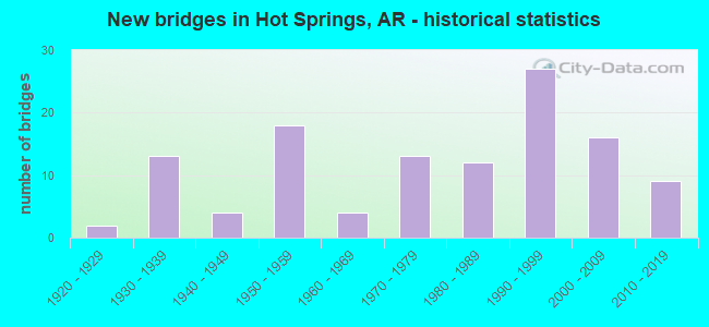
- New bridges - historical statistics
- 21920-1929
- 131930-1939
- 41940-1949
- 181950-1959
- 41960-1969
- 131970-1979
- 121980-1989
- 271990-1999
- 162000-2009
- 92010-2019

- Reconstructed bridges - Historical Statistics
- 21950-1959
- 41960-1969
- 21970-1979
- 11980-1989
- 21990-1999
- 12000-2009


- Bridge Condition - Deck
- 8.3%Very good
- 59.4%Good
- 25.0%Satisfactory
- 7.3%Fair

- Bridge Condition - Superstructure
- 1.0%Excellent
- 26.0%Very good
- 34.4%Good
- 24.0%Satisfactory
- 13.5%Fair
- 1.0%Poor

- Bridge Condition - Substructure
- 2.1%Excellent
- 13.5%Very good
- 34.4%Good
- 31.3%Satisfactory
- 18.8%Fair

- Bridge Condition - Channel
- 1.1%Excellent
- 21.3%Very good
- 26.6%Good
- 39.4%Satisfactory
- 11.7%Fair

- Bridge Condition - Culverts
- 9.1%Very good
- 40.9%Good
- 45.5%Satisfactory
- 4.5%Fair
Find on map >> Show street view
Structure Number: A6808, Location: 3.6 Mi. E SH 7 (Lat: 34.477989, Lng: -92.985106), Route carried "on" structure: US 70, Year Built: 2002, Status: Open, Structure Length: 7.25m (23.79ft), Average Daily Traffic: 7,500 (year 2018), Truck Traffic: 1%, Average Future Daily Traffic: 7,229 (year 2028), Design Load: HS 20, Features Intersected: East Gulpha Creek
Minimum Vertical Clearance: 30+ m (98+ ft), Kilometerpoint: 1.255, Lanes on structure: 2, Owner: State Highway Agency, Approaching Roadway Width: 12.2m (40.0ft), Skew: 3 degrees, Material/Design: Steel continuous, Design/Construction: Stringer/Multi-beam, Number Of Spans In Main Unit: 5, Length of Maximum Span: 15.5m (50.9ft), Curb-To-Curb Width: 12.0m (39.4ft), Out-to-Out Width: 12.9m (42.3ft)
Condition: Deck: Good, Superstructure: Very good, Substructure: Good, Channel: Very good, Operating Rating: 54.4 metric tons, Method Used To Determine Operating Rating: Load Factor (LF), Inventory Rating: 32.7 metric tons, Method Used To Determine Inventory Rating: Load Factor (LF), Structural Evaluation: Better than present minimum criteria, Deck Geometry: Equal to present minimum criteria, Waterway Adequacy: Equal to present desirable criteria, Approach Roadway Alignment: Equal to present desirable criteria, Designated Inspection Frequency: Every 24 months, Critical Feature Inspection Frequency: Every 24 months, Inspection Date: September 2020, Deck Structure Type: Concrete Cast-file-Place, Wearing Surface/Protective System: Wearing Surface: Monolithic Concrete, Deck Protection: Epoxy Coated Reinforcing
Find on map >> Show street view
Structure Number: A6809, Location: 4.1 Mi. E SH 7 (Lat: 34.484850, Lng: -92.981481), Route carried "on" structure: US 70, Year Built: 2002, Status: Open, Structure Length: 15.73m (51.61ft), Average Daily Traffic: 7,500 (year 2018), Truck Traffic: 1%, Average Future Daily Traffic: 7,229 (year 2028), Design Load: HS 20, Features Intersected: Bald Mt. Rd. & Gulpha Cr
Minimum Vertical Clearance: 30+ m (98+ ft), Kilometerpoint: 2.092, Lanes on structure: 2, Lanes under structure: 2, Owner: State Highway Agency, Approaching Roadway Width: 12.2m (40.0ft), Skew: 3 degrees, Material/Design: Steel continuous, Design/Construction: Stringer/Multi-beam, Number Of Spans In Main Unit: 8, Length of Maximum Span: 21.9m (71.9ft), Curb-To-Curb Width: 12.0m (39.4ft), Out-to-Out Width: 12.9m (42.3ft)
Condition: Deck: Good, Superstructure: Very good, Substructure: Good, Channel: Satisfactory, Operating Rating: 54.4 metric tons, Method Used To Determine Operating Rating: Load Factor (LF), Inventory Rating: 32.7 metric tons, Method Used To Determine Inventory Rating: Load Factor (LF), Structural Evaluation: Better than present minimum criteria, Deck Geometry: Equal to present minimum criteria, Underclear: Equal to present desirable criteria, Waterway Adequacy: Equal to present desirable criteria, Approach Roadway Alignment: Equal to present desirable criteria, Designated Inspection Frequency: Every 24 months, Critical Feature Inspection Frequency: Every 24 months, Inspection Date: July 2020, Deck Structure Type: Concrete Cast-file-Place, Wearing Surface/Protective System: Wearing Surface: Monolithic Concrete, Deck Protection: Epoxy Coated Reinforcing
Find on map >> Show street view
Structure Number: A7135, Location: 6.19 MI E of SH 7 (Lat: 34.506547, Lng: -92.965189), Route carried "on" structure: US 70, Year Built: 2018, Status: Open, Structure Length: 9.67m (31.73ft), Average Daily Traffic: 14,000 (year 2018), Truck Traffic: 7%, Average Future Daily Traffic: 13,500 (year 2036), Design Load: HL 93, Features Intersected: Cedar Creek
Minimum Vertical Clearance: 30+ m (98+ ft), Kilometerpoint: 5.198, Lanes on structure: 2, Base Highway Network: Yes (Inventory Route: 700, Subroute: 10), Owner: State Highway Agency, Approaching Roadway Width: 12.2m (40.0ft), Material/Design: Steel continuous, Design/Construction: Stringer/Multi-beam, Number Of Spans In Main Unit: 4, Length of Maximum Span: 25.6m (84.0ft), Curb or Sidewalk Widths: Left: 2.4m (7.9ft), Right: 2.4m (7.9ft), Curb-To-Curb Width: 12.2m (40.0ft), Out-to-Out Width: 13.2m (43.3ft)
Condition: Deck: Very good, Superstructure: Excellent, Substructure: Excellent, Channel: Excellent, Operating Rating: 54.4 metric tons, Method Used To Determine Operating Rating: Load and Resistance Factor (LRFR), Inventory Rating: 32.7 metric tons, Method Used To Determine Inventory Rating: Load and Resistance Factor (LRFR), Structural Evaluation: Superior to present desirable criteria, Deck Geometry: Better than present minimum criteria, Waterway Adequacy: Superior to present desirable criteria, Approach Roadway Alignment: Better than present minimum criteria, Designated Inspection Frequency: Every 24 months, Critical Feature Inspection Frequency: Every 24 months, Inspection Date: May 2020, Deck Structure Type: Concrete Cast-file-Place, Wearing Surface/Protective System: Deck Protection: Epoxy Coated Reinforcing
Find on map >> Show street view
Structure Number: B2942, Location: 1.94 MI E OF SH 7 HOT SPR (Lat: 34.518861, Lng: -93.032369), Route carried "on" structure: ServiceUS 70, Year Built: 1958, Status: Open, Structure Length: 4.57m (14.99ft), Average Daily Traffic: 500 (year 2018), Truck Traffic: 1%, Average Future Daily Traffic: 550 (year 2034), Design Load: H 20, Features Intersected: GULPHA CREEK, Facility Carried by Structure: E B FRONTAGE RD
Minimum Vertical Clearance: 30+ m (98+ ft), Kilometerpoint: 3.121, Lanes on structure: 2, Owner: State Highway Agency, Approaching Roadway Width: 8.8m (28.9ft), Material/Design: Concrete, Design/Construction: Slab, Number Of Spans In Main Unit: 6, Length of Maximum Span: 7.6m (24.9ft), Curb or Sidewalk Widths: Left: 0.5m (1.6ft), Right: 0.5m (1.6ft), Curb-To-Curb Width: 7.9m (25.9ft), Out-to-Out Width: 9.0m (29.5ft)
Condition: Deck: Fair, Superstructure: Fair, Substructure: Fair, Channel: Good, Operating Rating: 46.3 metric tons, Method Used To Determine Operating Rating: Load Factor (LF), Inventory Rating: 27.2 metric tons, Method Used To Determine Inventory Rating: Load Factor (LF), Structural Evaluation: Somewhat better than minimum adequacy, Deck Geometry: Somewhat better than minimum adequacy, Waterway Adequacy: Equal to present desirable criteria, Approach Roadway Alignment: Equal to present desirable criteria, Length Of Structure Improvement: 5.49m (18.01ft), Designated Inspection Frequency: Every 24 months, Critical Feature Inspection Frequency: Every 24 months, Inspection Date: December 2021, Roadway Improvement Cost: $341,000, Total Project Cost: $959,000, Deck Structure Type: Concrete Cast-file-Place, Wearing Surface/Protective System: Wearing Surface: Monolithic Concrete
Find on map >> Show street view
Structure Number: B2943, Location: 3.52 MI E OF SH 7 HOT SPR (Lat: 34.508083, Lng: -93.009750), Route carried "on" structure: ServiceUS 70, Year Built: 1958, Status: Open, Structure Length: 4.57m (14.99ft), Average Daily Traffic: 500 (year 2018), Truck Traffic: 5%, Average Future Daily Traffic: 550 (year 2034), Design Load: H 20, Features Intersected: Br. Gulpha Creek
Minimum Vertical Clearance: 30+ m (98+ ft), Kilometerpoint: 5.663, Lanes on structure: 2, Owner: State Highway Agency, Approaching Roadway Width: 8.5m (27.9ft), Skew: 3 degrees, Material/Design: Concrete, Design/Construction: Slab, Number Of Spans In Main Unit: 6, Length of Maximum Span: 7.6m (24.9ft), Curb or Sidewalk Widths: Left: 0.5m (1.6ft), Right: 0.5m (1.6ft), Curb-To-Curb Width: 7.9m (25.9ft), Out-to-Out Width: 9.0m (29.5ft)
Condition: Deck: Good, Superstructure: Good, Substructure: Fair, Channel: Satisfactory, Operating Rating: 45.4 metric tons, Method Used To Determine Operating Rating: Load Factor (LF), Inventory Rating: 27.2 metric tons, Method Used To Determine Inventory Rating: Load Factor (LF), Structural Evaluation: Somewhat better than minimum adequacy, Deck Geometry: Somewhat better than minimum adequacy, Waterway Adequacy: Equal to present desirable criteria, Approach Roadway Alignment: Equal to present desirable criteria, Length Of Structure Improvement: 5.49m (18.01ft), Designated Inspection Frequency: Every 24 months, Critical Feature Inspection Frequency: Every 24 months, Inspection Date: July 2021, Roadway Improvement Cost: $341,000, Total Project Cost: $959,000, Deck Structure Type: Concrete Cast-file-Place, Wearing Surface/Protective System: Wearing Surface: Monolithic Concrete
Find on map >> Show street view
Structure Number: B6376, Location: 1.7 MI WEST SH 7 (Lat: 34.468411, Lng: -93.088253), Route carried "on" structure: US 270, Year Built: 1992, Status: Open, Structure Length: 5.43m (17.81ft), Average Daily Traffic: 20,058 (year 2018), Truck Traffic: 3%, Average Future Daily Traffic: 13,801 (year 2028), Design Load: HS 20, Features Intersected: Lakeshore Dr.
Minimum Vertical Clearance: 30+ m (98+ ft), Kilometerpoint: 34.102, Lanes on structure: 2, Lanes under structure: 2, Base Highway Network: Yes, Owner: State Highway Agency, Approaching Roadway Width: 12.2m (40.0ft), Skew: 1 degrees, Material/Design: Steel, Design/Construction: Stringer/Multi-beam, Number Of Spans In Main Unit: 3, Length of Maximum Span: 24.7m (81.0ft), Curb-To-Curb Width: 14.4m (47.2ft), Out-to-Out Width: 21.0m (68.9ft)
Condition: Deck: Good, Superstructure: Good, Substructure: Good, Operating Rating: 54.4 metric tons, Method Used To Determine Operating Rating: Load Factor (LF), Inventory Rating: 32.7 metric tons, Method Used To Determine Inventory Rating: Load Factor (LF), Structural Evaluation: Better than present minimum criteria, Deck Geometry: Superior to present desirable criteria, Underclear: Better than present minimum criteria, Approach Roadway Alignment: Equal to present desirable criteria, Designated Inspection Frequency: Every 24 months, Critical Feature Inspection Frequency: Every 24 months, Inspection Date: May 2021, Deck Structure Type: Concrete Cast-file-Place, Wearing Surface/Protective System: Wearing Surface: Epoxy Overlay, Deck Protection: Epoxy Coated Reinforcing
Find on map >> Show street view
Structure Number: B6426, Location: 0.88 MI E SH 7 (Lat: 34.464125, Lng: -93.044219), Route carried "on" structure: US 270, Year Built: 1993, Status: Open, Structure Length: 10.61m (34.81ft), Average Daily Traffic: 17,449 (year 2018), Truck Traffic: 4%, Average Future Daily Traffic: 22,345 (year 2028), Design Load: HS 20, Features Intersected: HOT SPRINGS CREEK
Minimum Vertical Clearance: 30+ m (98+ ft), Kilometerpoint: 1.416, Lanes on structure: 2, Base Highway Network: Yes, Owner: State Highway Agency, Approaching Roadway Width: 12.5m (41.0ft), Skew: 3 degrees, Material/Design: Steel continuous, Design/Construction: Stringer/Multi-beam, Number Of Spans In Main Unit: 5, Length of Maximum Span: 22.9m (75.1ft), Curb-To-Curb Width: 12.0m (39.4ft), Out-to-Out Width: 12.9m (42.3ft)
Condition: Deck: Good, Superstructure: Good, Substructure: Good, Channel: Good, Operating Rating: 54.4 metric tons, Method Used To Determine Operating Rating: Load Factor (LF), Inventory Rating: 32.7 metric tons, Method Used To Determine Inventory Rating: Load Factor (LF), Structural Evaluation: Better than present minimum criteria, Deck Geometry: Equal to present minimum criteria, Waterway Adequacy: Equal to present desirable criteria, Approach Roadway Alignment: Equal to present desirable criteria, Designated Inspection Frequency: Every 24 months, Critical Feature Inspection Frequency: Every 24 months, Inspection Date: October 2020, Deck Structure Type: Concrete Cast-file-Place, Wearing Surface/Protective System: Wearing Surface: Monolithic Concrete, Deck Protection: Epoxy Coated Reinforcing
Find on map >> Show street view
Structure Number: B6427, Location: 1.9 MI E SH7(Bypass) (Lat: 34.464011, Lng: -93.027558), Route carried "on" structure: US 270, Year Built: 1993, Status: Open, Structure Length: 4.63m (15.19ft), Average Daily Traffic: 17,449 (year 2018), Truck Traffic: 4%, Average Future Daily Traffic: 22,345 (year 2028), Design Load: HS 20, Features Intersected: SHADY GROVE RD
Minimum Vertical Clearance: 30+ m (98+ ft), Kilometerpoint: 3.026, Lanes on structure: 2, Lanes under structure: 2, Base Highway Network: Yes, Owner: State Highway Agency, Approaching Roadway Width: 12.5m (41.0ft), Skew: 1 degrees, Material/Design: Steel continuous, Design/Construction: Stringer/Multi-beam, Number Of Spans In Main Unit: 3, Length of Maximum Span: 20.1m (65.9ft), Curb-To-Curb Width: 12.0m (39.4ft), Out-to-Out Width: 12.9m (42.3ft)
Condition: Deck: Good, Superstructure: Very good, Substructure: Very good, Operating Rating: 54.4 metric tons, Method Used To Determine Operating Rating: Load Factor (LF), Inventory Rating: 32.7 metric tons, Method Used To Determine Inventory Rating: Load Factor (LF), Structural Evaluation: Equal to present desirable criteria, Deck Geometry: Equal to present minimum criteria, Underclear: Equal to present minimum criteria, Approach Roadway Alignment: Equal to present desirable criteria, Designated Inspection Frequency: Every 24 months, Critical Feature Inspection Frequency: Every 24 months, Inspection Date: July 2020, Deck Structure Type: Concrete Cast-file-Place, Wearing Surface/Protective System: Wearing Surface: Monolithic Concrete, Deck Protection: Epoxy Coated Reinforcing
Find on map >> Show street view
Structure Number: B6493, Location: 2.3 MI E SH 7 (Lat: 34.465589, Lng: -93.021250), Route carried "on" structure: US 270, Year Built: 1993, Status: Open, Structure Length: 7.89m (25.89ft), Average Daily Traffic: 17,449 (year 2018), Truck Traffic: 4%, Average Future Daily Traffic: 22,345 (year 2028), Design Load: HS 20, Features Intersected: SH 128
Minimum Vertical Clearance: 30+ m (98+ ft), Kilometerpoint: 3.636, Lanes on structure: 2, Lanes under structure: 4, Base Highway Network: Yes, Owner: State Highway Agency, Approaching Roadway Width: 12.5m (41.0ft), Material/Design: Steel continuous, Design/Construction: Stringer/Multi-beam, Number Of Spans In Main Unit: 3, Length of Maximum Span: 29.6m (97.1ft), Curb-To-Curb Width: 12.0m (39.4ft), Out-to-Out Width: 13.0m (42.7ft)
Condition: Deck: Good, Superstructure: Very good, Substructure: Good, Operating Rating: 54.4 metric tons, Method Used To Determine Operating Rating: Load Factor (LF), Inventory Rating: 32.7 metric tons, Method Used To Determine Inventory Rating: Load Factor (LF), Structural Evaluation: Better than present minimum criteria, Deck Geometry: Equal to present minimum criteria, Underclear: Better than present minimum criteria, Approach Roadway Alignment: Equal to present desirable criteria, Designated Inspection Frequency: Every 24 months, Critical Feature Inspection Frequency: Every 24 months, Inspection Date: July 2020, Deck Structure Type: Concrete Cast-file-Place, Wearing Surface/Protective System: Wearing Surface: Monolithic Concrete, Deck Protection: Epoxy Coated Reinforcing
Find on map >> Show street view
Structure Number: B6806, Location: 3.1 mi. E Sh 7 (Lat: 34.470822, Lng: -92.989533), Route carried "on" structure: US 70, Year Built: 2002, Status: Open, Structure Length: 8.78m (28.81ft), Average Daily Traffic: 7,500 (year 2018), Truck Traffic: 12%, Average Future Daily Traffic: 7,229 (year 2028), Design Load: HS 20, Features Intersected: US 270B
Minimum Vertical Clearance: 30+ m (98+ ft), Kilometerpoint: 0.370, Lanes on structure: 2, Lanes under structure: 5, Owner: State Highway Agency, Approaching Roadway Width: 12.2m (40.0ft), Skew: 1 degrees, Material/Design: Steel continuous, Design/Construction: Stringer/Multi-beam, Number Of Spans In Main Unit: 4, Length of Maximum Span: 27.7m (90.9ft), Curb-To-Curb Width: 12.2m (40.0ft), Out-to-Out Width: 12.9m (42.3ft)
Condition: Deck: Good, Superstructure: Very good, Substructure: Very good, Operating Rating: 53.5 metric tons, Method Used To Determine Operating Rating: Load Factor (LF), Inventory Rating: 31.8 metric tons, Method Used To Determine Inventory Rating: Load Factor (LF), Structural Evaluation: Better than present minimum criteria, Deck Geometry: Better than present minimum criteria, Underclear: Equal to present desirable criteria, Approach Roadway Alignment: Equal to present desirable criteria, Designated Inspection Frequency: Every 24 months, Critical Feature Inspection Frequency: Every 24 months, Inspection Date: July 2020, Deck Structure Type: Concrete Cast-file-Place, Wearing Surface/Protective System: Wearing Surface: Monolithic Concrete, Deck Protection: Epoxy Coated Reinforcing
Find on map >> Show street view
Structure Number: B6807, Location: 3.3 Mi. E SH 7 (Lat: 34.474042, Lng: -92.987428), Route carried "on" structure: US 70, Year Built: 2002, Status: Open, Structure Length: 18.53m (60.79ft), Average Daily Traffic: 7,500 (year 2018), Truck Traffic: 12%, Average Future Daily Traffic: 7,229 (year 2028), Design Load: HS 20, Features Intersected: Gulpha Cr.,Westinghouse
Minimum Vertical Clearance: 30+ m (98+ ft), Kilometerpoint: 0.756, Lanes on structure: 3, Lanes under structure: 2, Owner: State Highway Agency, Approaching Roadway Width: 14.5m (47.6ft), Skew: 4 degrees, Material/Design: Steel continuous, Design/Construction: Stringer/Multi-beam, Number Of Spans In Main Unit: 6, Length of Maximum Span: 36.6m (120.1ft), Curb-To-Curb Width: 14.5m (47.6ft), Out-to-Out Width: 15.2m (49.9ft)
Condition: Deck: Good, Superstructure: Good, Substructure: Very good, Channel: Very good, Operating Rating: 54.4 metric tons, Method Used To Determine Operating Rating: Load Factor (LF), Inventory Rating: 32.7 metric tons, Method Used To Determine Inventory Rating: Load Factor (LF), Structural Evaluation: Better than present minimum criteria, Deck Geometry: Meets minimum limits, Underclear: High priority of corrective action, Waterway Adequacy: Equal to present desirable criteria, Approach Roadway Alignment: Equal to present desirable criteria, Designated Inspection Frequency: Every 24 months, Critical Feature Inspection Frequency: Every 24 months, Inspection Date: September 2020, Deck Structure Type: Concrete Cast-file-Place, Wearing Surface/Protective System: Wearing Surface: Monolithic Concrete, Deck Protection: Epoxy Coated Reinforcing
Find on map >> Show street view
Structure Number: B6808, Location: 3.6 Mi. E SH 7 (Lat: 34.477892, Lng: -92.985039), Route carried "on" structure: US 70, Year Built: 2002, Status: Open, Structure Length: 7.25m (23.79ft), Average Daily Traffic: 7,500 (year 2018), Truck Traffic: 12%, Average Future Daily Traffic: 19,400 (year 2038), Design Load: HS 20, Features Intersected: East Gulpha Creek
Minimum Vertical Clearance: 30+ m (98+ ft), Kilometerpoint: 1.255, Lanes on structure: 2, Owner: State Highway Agency, Approaching Roadway Width: 12.2m (40.0ft), Skew: 3 degrees, Material/Design: Steel continuous, Design/Construction: Stringer/Multi-beam, Number Of Spans In Main Unit: 5, Length of Maximum Span: 15.5m (50.9ft), Curb-To-Curb Width: 12.0m (39.4ft), Out-to-Out Width: 12.9m (42.3ft)
Condition: Deck: Very good, Superstructure: Very good, Substructure: Good, Channel: Very good, Operating Rating: 54.4 metric tons, Method Used To Determine Operating Rating: Load Factor (LF), Inventory Rating: 32.7 metric tons, Method Used To Determine Inventory Rating: Load Factor (LF), Structural Evaluation: Better than present minimum criteria, Deck Geometry: Equal to present minimum criteria, Waterway Adequacy: Equal to present desirable criteria, Approach Roadway Alignment: Equal to present desirable criteria, Designated Inspection Frequency: Every 24 months, Critical Feature Inspection Frequency: Every 24 months, Inspection Date: September 2020, Deck Structure Type: Concrete Cast-file-Place, Wearing Surface/Protective System: Wearing Surface: Monolithic Concrete, Deck Protection: Epoxy Coated Reinforcing
Find on map >> Show street view
Structure Number: B6809, Location: 4.1 Mi. E SH 7 (Lat: 34.484822, Lng: -92.981378), Route carried "on" structure: US 70, Year Built: 2002, Status: Open, Structure Length: 16.46m (54.00ft), Average Daily Traffic: 7,500 (year 2018), Truck Traffic: 12%, Average Future Daily Traffic: 7,229 (year 2028), Design Load: HS 20, Features Intersected: Bald Mt. Rd & Gulpha Cr
Minimum Vertical Clearance: 30+ m (98+ ft), Kilometerpoint: 2.092, Lanes on structure: 2, Lanes under structure: 2, Owner: State Highway Agency, Approaching Roadway Width: 12.2m (40.0ft), Skew: 3 degrees, Material/Design: Steel continuous, Design/Construction: Stringer/Multi-beam, Number Of Spans In Main Unit: 8, Length of Maximum Span: 21.9m (71.9ft), Curb-To-Curb Width: 12.0m (39.4ft), Out-to-Out Width: 12.9m (42.3ft)
Condition: Deck: Good, Superstructure: Very good, Substructure: Good, Channel: Satisfactory, Operating Rating: 54.4 metric tons, Method Used To Determine Operating Rating: Load Factor (LF), Inventory Rating: 32.7 metric tons, Method Used To Determine Inventory Rating: Load Factor (LF), Structural Evaluation: Better than present minimum criteria, Deck Geometry: Equal to present minimum criteria, Underclear: Superior to present desirable criteria, Waterway Adequacy: Equal to present desirable criteria, Approach Roadway Alignment: Equal to present desirable criteria, Designated Inspection Frequency: Every 24 months, Critical Feature Inspection Frequency: Every 24 months, Inspection Date: July 2020, Deck Structure Type: Concrete Cast-file-Place, Wearing Surface/Protective System: Wearing Surface: Monolithic Concrete, Deck Protection: Epoxy Coated Reinforcing
Find on map >> Show street view
Structure Number: C2942, Location: 1.94 MI EAST OF SH 7 (Lat: 34.519450, Lng: -93.032561), Route carried "on" structure: ServiceUS 70, Year Built: 1958, Status: Open, Structure Length: 4.57m (14.99ft), Average Daily Traffic: 1,451 (year 2018), Truck Traffic: 1%, Average Future Daily Traffic: 550 (year 2034), Design Load: H 20, Features Intersected: GULPHA CREEK
Minimum Vertical Clearance: 30+ m (98+ ft), Kilometerpoint: 3.121, Lanes on structure: 2, Owner: State Highway Agency, Approaching Roadway Width: 8.8m (28.9ft), Material/Design: Concrete, Design/Construction: Slab, Number Of Spans In Main Unit: 6, Length of Maximum Span: 7.6m (24.9ft), Curb or Sidewalk Widths: Left: 0.5m (1.6ft), Right: 0.5m (1.6ft), Curb-To-Curb Width: 7.9m (25.9ft), Out-to-Out Width: 9.0m (29.5ft)
Condition: Deck: Satisfactory, Superstructure: Satisfactory, Substructure: Fair, Channel: Good, Operating Rating: 46.3 metric tons, Method Used To Determine Operating Rating: Load Factor (LF), Inventory Rating: 27.2 metric tons, Method Used To Determine Inventory Rating: Load Factor (LF), Structural Evaluation: Somewhat better than minimum adequacy, Deck Geometry: Meets minimum limits, Waterway Adequacy: Equal to present desirable criteria, Approach Roadway Alignment: Equal to present desirable criteria, Length Of Structure Improvement: 5.49m (18.01ft), Designated Inspection Frequency: Every 24 months, Critical Feature Inspection Frequency: Every 24 months, Inspection Date: December 2021, Roadway Improvement Cost: $341,000, Total Project Cost: $959,000, Deck Structure Type: Concrete Cast-file-Place, Wearing Surface/Protective System: Wearing Surface: Monolithic Concrete
Find on map >> Show street view
Structure Number: C2943, Location: 3.52 MI EAST OF SH 7 (Lat: 34.508831, Lng: -93.009381), Route carried "on" structure: ServiceUS 70, Year Built: 1958, Status: Open, Structure Length: 4.57m (14.99ft), Average Daily Traffic: 1,451 (year 2018), Truck Traffic: 4%, Average Future Daily Traffic: 550 (year 2034), Design Load: H 20, Features Intersected: Br. Gulpha Creek
Minimum Vertical Clearance: 30+ m (98+ ft), Kilometerpoint: 5.663, Lanes on structure: 2, Owner: State Highway Agency, Approaching Roadway Width: 8.5m (27.9ft), Skew: 3 degrees, Material/Design: Concrete, Design/Construction: Slab, Number Of Spans In Main Unit: 6, Length of Maximum Span: 7.6m (24.9ft), Curb or Sidewalk Widths: Left: 0.5m (1.6ft), Right: 0.5m (1.6ft), Curb-To-Curb Width: 7.9m (25.9ft), Out-to-Out Width: 9.0m (29.5ft)
Condition: Deck: Good, Superstructure: Good, Substructure: Satisfactory, Channel: Good, Operating Rating: 45.4 metric tons, Method Used To Determine Operating Rating: Load Factor (LF), Inventory Rating: 27.2 metric tons, Method Used To Determine Inventory Rating: Load Factor (LF), Structural Evaluation: Equal to present minimum criteria, Deck Geometry: Meets minimum limits, Waterway Adequacy: Equal to present desirable criteria, Approach Roadway Alignment: Equal to present desirable criteria, Length Of Structure Improvement: 5.49m (18.01ft), Designated Inspection Frequency: Every 24 months, Critical Feature Inspection Frequency: Every 24 months, Inspection Date: July 2021, Roadway Improvement Cost: $341,000, Total Project Cost: $959,000, Deck Structure Type: Concrete Cast-file-Place, Wearing Surface/Protective System: Wearing Surface: Monolithic Concrete
Find on map >> Show street view
Structure Number: C6376, Location: 1.7 MI WEST SH 7 (Lat: 34.468500, Lng: -93.087869), Route carried "on" structure: Ramp US 270, Year Built: 1992, Status: Open, Structure Length: 3.66m (12.01ft), Average Daily Traffic: 1,789 (year 2011), Truck Traffic: 1%, Average Future Daily Traffic: 2,750 (year 2028), Design Load: HS 20, Features Intersected: LAKESHORE DRIVE
Minimum Vertical Clearance: 30+ m (98+ ft), Kilometerpoint: 34.102, Lanes on structure: 1, Lanes under structure: 2, Base Highway Network: Yes, Owner: State Highway Agency, Approaching Roadway Width: 7.6m (24.9ft), Material/Design: Steel, Design/Construction: Stringer/Multi-beam, Number Of Spans In Main Unit: 2, Length of Maximum Span: 24.4m (80.1ft), Curb-To-Curb Width: 7.6m (24.9ft), Out-to-Out Width: 8.5m (27.9ft)
Condition: Deck: Good, Superstructure: Good, Substructure: Good, Operating Rating: 54.4 metric tons, Method Used To Determine Operating Rating: Load Factor (LF), Inventory Rating: 32.7 metric tons, Method Used To Determine Inventory Rating: Load Factor (LF), Structural Evaluation: Better than present minimum criteria, Deck Geometry: Better than present minimum criteria, Underclear: Better than present minimum criteria, Approach Roadway Alignment: Equal to present desirable criteria, Designated Inspection Frequency: Every 24 months, Critical Feature Inspection Frequency: Every 24 months, Inspection Date: May 2021, Deck Structure Type: Concrete Cast-file-Place, Wearing Surface/Protective System: Wearing Surface: Epoxy Overlay, Deck Protection: Epoxy Coated Reinforcing
Find on map >> Show street view
Structure Number: M1314, Location: .29 MI E OF SH 7 HOT SPRG (Lat: 34.502850, Lng: -93.050611), Route carried "on" structure: Business US 70, Year Built: 1929, Status: Open, Structure Length: 1.13m (3.71ft), Average Daily Traffic: 20,000 (year 2018), Truck Traffic: 1%, Average Future Daily Traffic: 30,232 (year 2028), Features Intersected: HOT SPRINGS CREEK
Minimum Vertical Clearance: 30+ m (98+ ft), Kilometerpoint: 0.467, Lanes on structure: 4, Base Highway Network: Yes, Owner: State Highway Agency, Approaching Roadway Width: 15.2m (49.9ft), Material/Design: Concrete continuous, Design/Construction: Slab, Number Of Spans In Main Unit: 3, Length of Maximum Span: 3.7m (12.1ft), Curb or Sidewalk Widths: Left: 1.5m (4.9ft), Right: 1.5m (4.9ft), Curb-To-Curb Width: 24.4m (80.1ft), Out-to-Out Width: 27.4m (89.9ft)
Condition: Deck: Satisfactory, Superstructure: Satisfactory, Substructure: Satisfactory, Channel: Satisfactory, Operating Rating: 29.0 metric tons, Method Used To Determine Operating Rating: Load Factor (LF), Inventory Rating: 17.2 metric tons, Method Used To Determine Inventory Rating: Load Factor (LF), Structural Evaluation: Meets minimum limits, Deck Geometry: Superior to present desirable criteria, Waterway Adequacy: Equal to present desirable criteria, Approach Roadway Alignment: Equal to present desirable criteria, Designated Inspection Frequency: Every 24 months, Critical Feature Inspection Frequency: Every 24 months, Inspection Date: July 2021, Deck Structure Type: Concrete Cast-file-Place, Wearing Surface/Protective System: Wearing Surface: Bituminous
Find on map >> Show street view
Structure Number: M1319, Location: 1.37 MI S OF SH 7 HOT SPR (Lat: 34.521889, Lng: -93.034639), Route carried "on" structure: Spur State highway 7, Year Built: 1938, Status: Open, Structure Length: 1.38m (4.53ft), Average Daily Traffic: 7,900 (year 2018), Truck Traffic: 1%, Average Future Daily Traffic: 11,567 (year 2028), Design Load: H 15, Features Intersected: GULPHA CREEK
Minimum Vertical Clearance: 30+ m (98+ ft), Kilometerpoint: 0.402, Lanes on structure: 2, Owner: State Highway Agency, Approaching Roadway Width: 8.2m (26.9ft), Skew: 1 degrees, Material/Design: Concrete, Design/Construction: Arch - Deck, Number Of Spans In Main Unit: 1, Length of Maximum Span: 12.6m (41.3ft), Curb or Sidewalk Widths: Left: 0.1m (0.3ft), Right: 0.1m (0.3ft), Curb-To-Curb Width: 8.2m (26.9ft), Out-to-Out Width: 9.1m (29.9ft)
Condition: Deck: Good, Superstructure: Good, Substructure: Satisfactory, Channel: Satisfactory, Operating Rating: 36.3 metric tons, Method Used To Determine Operating Rating: Load Factor (LF), Inventory Rating: 21.8 metric tons, Method Used To Determine Inventory Rating: Load Factor (LF), Structural Evaluation: Somewhat better than minimum adequacy, Deck Geometry: High priority of replacement, Waterway Adequacy: Better than present minimum criteria, Approach Roadway Alignment: Equal to present minimum criteria, Length Of Structure Improvement: 2.13m (6.99ft), Designated Inspection Frequency: Every 24 months, Critical Feature Inspection Frequency: Every 24 months, Inspection Date: April 2020, Roadway Improvement Cost: $324,000, Total Project Cost: $599,000, Wearing Surface/Protective System: Wearing Surface: Bituminous
Find on map >> Show street view
Structure Number: M132, Location: 1.0 MI S OF SH 7 AT HOT S (Lat: 34.526519, Lng: -93.036078), Route carried "on" structure: Spur State highway 7, Year Built: 1939, Status: Open, Structure Length: 1.25m (4.10ft), Average Daily Traffic: 7,900 (year 2018), Truck Traffic: 1%, Average Future Daily Traffic: 9,400 (year 2038), Features Intersected: GULPHA CREEK
Minimum Vertical Clearance: 30+ m (98+ ft), Kilometerpoint: 1.014, Lanes on structure: 2, Owner: State Highway Agency, Approaching Roadway Width: 7.0m (23.0ft), Skew: 4 degrees, Material/Design: Concrete, Design/Construction: Arch - Deck, Number Of Spans In Main Unit: 1, Length of Maximum Span: 11.9m (39.0ft), Curb or Sidewalk Widths: Left: 0.1m (0.3ft), Right: 0.1m (0.3ft), Curb-To-Curb Width: 8.5m (27.9ft), Out-to-Out Width: 9.1m (29.9ft)
Condition: Deck: Satisfactory, Superstructure: Satisfactory, Substructure: Satisfactory, Channel: Good, Operating Rating: 38.1 metric tons, Method Used To Determine Operating Rating: Load Factor (LF), Inventory Rating: 22.7 metric tons, Method Used To Determine Inventory Rating: Load Factor (LF), Structural Evaluation: Somewhat better than minimum adequacy, Deck Geometry: High priority of replacement, Waterway Adequacy: Equal to present desirable criteria, Approach Roadway Alignment: Equal to present minimum criteria, Length Of Structure Improvement: 1.98m (6.50ft), Designated Inspection Frequency: Every 24 months, Critical Feature Inspection Frequency: Every 24 months, Inspection Date: April 2020, Roadway Improvement Cost: $324,000, Total Project Cost: $587,000, Wearing Surface/Protective System: Wearing Surface: Bituminous
Find on map >> Show street view
Structure Number: M1321, Location: .8 MI S OF SH 7 HOT SPRNG (Lat: 34.528689, Lng: -93.033458), Route carried "on" structure: Spur State highway 7, Year Built: 1938, Status: Open, Structure Length: 1.25m (4.10ft), Average Daily Traffic: 7,900 (year 2018), Truck Traffic: 1%, Average Future Daily Traffic: 9,400 (year 2038), Features Intersected: GULPHA CREEK
Minimum Vertical Clearance: 30+ m (98+ ft), Kilometerpoint: 1.368, Lanes on structure: 2, Owner: State Highway Agency, Approaching Roadway Width: 7.0m (23.0ft), Skew: 4 degrees, Material/Design: Concrete, Design/Construction: Arch - Deck, Number Of Spans In Main Unit: 1, Length of Maximum Span: 11.9m (39.0ft), Curb or Sidewalk Widths: Left: 0.1m (0.3ft), Right: 0.1m (0.3ft), Curb-To-Curb Width: 8.5m (27.9ft), Out-to-Out Width: 9.1m (29.9ft)
Condition: Deck: Satisfactory, Superstructure: Satisfactory, Substructure: Satisfactory, Channel: Satisfactory, Operating Rating: 37.2 metric tons, Method Used To Determine Operating Rating: Load Factor (LF), Inventory Rating: 21.8 metric tons, Method Used To Determine Inventory Rating: Load Factor (LF), Structural Evaluation: Somewhat better than minimum adequacy, Deck Geometry: High priority of replacement, Waterway Adequacy: Equal to present desirable criteria, Approach Roadway Alignment: Equal to present minimum criteria, Length Of Structure Improvement: 1.98m (6.50ft), Designated Inspection Frequency: Every 24 months, Critical Feature Inspection Frequency: Every 24 months, Inspection Date: April 2020, Roadway Improvement Cost: $324,000, Total Project Cost: $587,000, Wearing Surface/Protective System: Wearing Surface: Bituminous
Find on map >> Show street view
Structure Number: M1322, Location: 0.5 MI SO OF JCT SH 7 (Lat: 34.533989, Lng: -93.029819), Route carried "on" structure: Spur State highway 7, Year Built: 1938, Year Reconstructed: 1973, Status: Open, Structure Length: 0.67m (2.20ft), Average Daily Traffic: 7,300 (year 2018), Truck Traffic: 3%, Average Future Daily Traffic: 8,149 (year 2028), Design Load: H 15, Features Intersected: GULPHA CREEK
Minimum Vertical Clearance: 30+ m (98+ ft), Kilometerpoint: 2.366, Lanes on structure: 2, Owner: State Highway Agency, Approaching Roadway Width: 7.3m (24.0ft), Skew: 3 degrees, Material/Design: Concrete, Design/Construction: Arch - Deck, Number Of Spans In Main Unit: 1, Length of Maximum Span: 6.1m (20.0ft), Curb or Sidewalk Widths: Left: 0.1m (0.3ft), Right: 0.1m (0.3ft), Curb-To-Curb Width: 8.5m (27.9ft), Out-to-Out Width: 9.1m (29.9ft)
Condition: Deck: Satisfactory, Superstructure: Fair, Substructure: Fair, Channel: Good, Operating Rating: 37.2 metric tons, Method Used To Determine Operating Rating: Load Factor (LF), Inventory Rating: 21.8 metric tons, Method Used To Determine Inventory Rating: Load Factor (LF), Structural Evaluation: Somewhat better than minimum adequacy, Deck Geometry: High priority of replacement, Waterway Adequacy: Equal to present desirable criteria, Approach Roadway Alignment: Equal to present desirable criteria, Length Of Structure Improvement: 1.37m (4.49ft), Designated Inspection Frequency: Every 24 months, Critical Feature Inspection Frequency: Every 24 months, Inspection Date: April 2020, Roadway Improvement Cost: $324,000, Total Project Cost: $534,000, Wearing Surface/Protective System: Wearing Surface: Bituminous
Find on map >> Show street view
Structure Number: M1609, Location: 0.2 MI S JCT US 70 (Lat: 34.475344, Lng: -93.116461), Route carried "on" structure: City street 31890, Year Built: 1935, Status: Open, Structure Length: 0.85m (2.79ft), Average Daily Traffic: 2,100 (year 2018), Truck Traffic: 1%, Average Future Daily Traffic: 3,345 (year 2011), Features Intersected: CREEK, Facility Carried by Structure: LAKESHORE DR 1.93
Minimum Vertical Clearance: 30+ m (98+ ft), Kilometerpoint: 3.104, Lanes on structure: 2, Owner: City or Municipal Highway Agency, Approaching Roadway Width: 7.3m (24.0ft), Material/Design: Concrete, Design/Construction: Slab, Number Of Spans In Main Unit: 2, Length of Maximum Span: 4.3m (14.1ft), Curb or Sidewalk Widths: Left: 0.2m (0.7ft), Right: 0.2m (0.7ft), Curb-To-Curb Width: 5.5m (18.0ft), Out-to-Out Width: 6.2m (20.3ft)
Condition: Deck: Good, Superstructure: Good, Substructure: Satisfactory, Channel: Satisfactory, Operating Rating: 27.2 metric tons, Method Used To Determine Operating Rating: Load Factor (LF), Inventory Rating: 16.3 metric tons, Method Used To Determine Inventory Rating: Load Factor (LF), Structural Evaluation: Meets minimum limits, Deck Geometry: High priority of replacement, Waterway Adequacy: Equal to present desirable criteria, Approach Roadway Alignment: Equal to present desirable criteria, Length Of Structure Improvement: 1.55m (5.09ft), Designated Inspection Frequency: Every 24 months, Critical Feature Inspection Frequency: Every 24 months, Inspection Date: April 2021, Roadway Improvement Cost: $187,000, Total Project Cost: $316,000, Deck Structure Type: Concrete Cast-file-Place, Wearing Surface/Protective System: Wearing Surface: Bituminous
Find on map >> Show street view
Structure Number: M161, Location: .2 W JCT US 270 & McLoed (Lat: 34.469881, Lng: -93.093375), Route carried "on" structure: City street 31890, Year Built: 1935, Status: Open, Structure Length: 1.34m (4.40ft), Average Daily Traffic: 2,100 (year 2018), Truck Traffic: 1%, Average Future Daily Traffic: 3,345 (year 2011), Features Intersected: STOKES CREEK, Facility Carried by Structure: LAKESHORE DR 3.80
Minimum Vertical Clearance: 30+ m (98+ ft), Kilometerpoint: 6.114, Lanes on structure: 2, Owner: City or Municipal Highway Agency, Approaching Roadway Width: 6.7m (22.0ft), Material/Design: Concrete, Design/Construction: Slab, Number Of Spans In Main Unit: 3, Length of Maximum Span: 4.3m (14.1ft), Curb or Sidewalk Widths: Left: 0.2m (0.7ft), Right: 0.2m (0.7ft), Curb-To-Curb Width: 5.5m (18.0ft), Out-to-Out Width: 6.3m (20.7ft)
Condition: Deck: Satisfactory, Superstructure: Satisfactory, Substructure: Satisfactory, Channel: Satisfactory, Operating Rating: 27.2 metric tons, Method Used To Determine Operating Rating: Load Factor (LF), Inventory Rating: 16.3 metric tons, Method Used To Determine Inventory Rating: Load Factor (LF), Structural Evaluation: Meets minimum limits, Deck Geometry: High priority of replacement, Waterway Adequacy: Equal to present minimum criteria, Approach Roadway Alignment: Equal to present minimum criteria, Length Of Structure Improvement: 2.07m (6.79ft), Designated Inspection Frequency: Every 24 months, Critical Feature Inspection Frequency: Every 24 months, Inspection Date: April 2021, Roadway Improvement Cost: $187,000, Total Project Cost: $343,000, Deck Structure Type: Concrete Cast-file-Place, Wearing Surface/Protective System: Wearing Surface: Bituminous
Find on map >> Show street view
Structure Number: M2637, Location: 270 @ Weston Rd. (Lat: 34.492961, Lng: -93.115111), Route carried "on" structure: US 270, Year Built: 1937, Year Reconstructed: 1985, Status: Open, Structure Length: 0.64m (2.10ft), Average Daily Traffic: 34,000 (year 2018), Truck Traffic: 3%, Average Future Daily Traffic: 46,268 (year 2027), Design Load: H 15, Features Intersected: DITCH
Minimum Vertical Clearance: 30+ m (98+ ft), Kilometerpoint: 28.984, Lanes on structure: 6, Base Highway Network: Yes, Owner: State Highway Agency, Approaching Roadway Width: 15.2m (49.9ft), Material/Design: Concrete, Design/Construction: Culvert, Number Of Spans In Main Unit: 2, Length of Maximum Span: 3.0m (9.8ft)
Condition: Channel: Fair, Culverts: Satisfactory, Operating Rating: 39.9 metric tons, Method Used To Determine Operating Rating: Load Factor (LF), Inventory Rating: 23.6 metric tons, Method Used To Determine Inventory Rating: Load Factor (LF), Structural Evaluation: Somewhat better than minimum adequacy, Waterway Adequacy: Equal to present minimum criteria, Approach Roadway Alignment: Equal to present desirable criteria, Designated Inspection Frequency: Every 24 months, Critical Feature Inspection Frequency: Every 24 months, Inspection Date: July 2021
Find on map >> Show street view
Structure Number: X0101, Location: 4.78 MI SE JCT SH 7 & 290 (Lat: 34.406639, Lng: -93.030100), Route carried "on" structure: State highway 290, Year Built: 1971, Status: Open, Structure Length: 0.82m (2.69ft), Average Daily Traffic: 2,100 (year 2018), Truck Traffic: 1%, Average Future Daily Traffic: 2,103 (year 2028), Design Load: H 20, Features Intersected: WHITE OAK CREEK
Minimum Vertical Clearance: 30+ m (98+ ft), Kilometerpoint: 7.691, Lanes on structure: 2, Owner: State Highway Agency, Approaching Roadway Width: 6.7m (22.0ft), Skew: 4 degrees, Material/Design: Concrete, Design/Construction: Culvert, Number Of Spans In Main Unit: 2, Length of Maximum Span: 3.7m (12.1ft)
Condition: Channel: Satisfactory, Culverts: Satisfactory, Operating Rating: 50.8 metric tons, Method Used To Determine Operating Rating: Load Factor (LF), Inventory Rating: 30.8 metric tons, Method Used To Determine Inventory Rating: Load Factor (LF), Structural Evaluation: Equal to present minimum criteria, Waterway Adequacy: Equal to present desirable criteria, Approach Roadway Alignment: Equal to present desirable criteria, Designated Inspection Frequency: Every 24 months, Critical Feature Inspection Frequency: Every 24 months, Inspection Date: November 2021
Find on map >> Show street view
Structure Number: X0102, Location: 8.39 MI SE JCT SH 7 & 290 (Lat: 34.426681, Lng: -92.989731), Route carried "on" structure: State highway 290, Year Built: 1971, Status: Open, Structure Length: 0.82m (2.69ft), Average Daily Traffic: 3,000 (year 2018), Truck Traffic: 2%, Average Future Daily Traffic: 3,549 (year 2028), Design Load: H 20, Features Intersected: CREEK
Minimum Vertical Clearance: 30+ m (98+ ft), Kilometerpoint: 13.501, Lanes on structure: 2, Owner: State Highway Agency, Approaching Roadway Width: 6.7m (22.0ft), Material/Design: Concrete, Design/Construction: Culvert, Number Of Spans In Main Unit: 3, Length of Maximum Span: 2.4m (7.9ft)
Condition: Channel: Satisfactory, Culverts: Satisfactory, Operating Rating: 49.9 metric tons, Method Used To Determine Operating Rating: Load Factor (LF), Inventory Rating: 29.9 metric tons, Method Used To Determine Inventory Rating: Load Factor (LF), Structural Evaluation: Equal to present minimum criteria, Waterway Adequacy: Equal to present desirable criteria, Approach Roadway Alignment: Equal to present desirable criteria, Designated Inspection Frequency: Every 24 months, Critical Feature Inspection Frequency: Every 24 months, Inspection Date: November 2021
Find on map >> Show street view
Structure Number: X0584, Location: 2.6 MI NE JCT 7S (Lat: 34.556719, Lng: -93.006700), Route carried "on" structure: State highway 7, Year Built: 1988, Status: Open, Structure Length: 1.16m (3.81ft), Average Daily Traffic: 9,400 (year 2018), Truck Traffic: 1%, Average Future Daily Traffic: 13,144 (year 2028), Design Load: H 20, Features Intersected: CREEK
Minimum Vertical Clearance: 30+ m (98+ ft), Kilometerpoint: 24.929, Lanes on structure: 2, Base Highway Network: Yes, Owner: State Highway Agency, Approaching Roadway Width: 12.2m (40.0ft), Material/Design: Concrete, Design/Construction: Culvert, Number Of Spans In Main Unit: 4, Length of Maximum Span: 2.7m (8.9ft)
Condition: Channel: Fair, Culverts: Satisfactory, Operating Rating: 32.7 metric tons, Method Used To Determine Operating Rating: Load Factor (LF), Inventory Rating: 19.1 metric tons, Method Used To Determine Inventory Rating: Load Factor (LF), Structural Evaluation: Meets minimum limits, Waterway Adequacy: Equal to present desirable criteria, Approach Roadway Alignment: Equal to present desirable criteria, Designated Inspection Frequency: Every 24 months, Critical Feature Inspection Frequency: Every 24 months, Inspection Date: October 2021
Find on map >> Show street view
Structure Number: X0585, Location: 2.6 MI NE JCT 7S (Lat: 34.555639, Lng: -93.009350), Route carried "on" structure: State highway 7, Year Built: 1988, Status: Open, Structure Length: 1.31m (4.30ft), Average Daily Traffic: 9,400 (year 2018), Truck Traffic: 1%, Average Future Daily Traffic: 13,144 (year 2028), Design Load: H 20, Features Intersected: CREEK
Minimum Vertical Clearance: 30+ m (98+ ft), Kilometerpoint: 24.657, Lanes on structure: 2, Base Highway Network: Yes, Owner: State Highway Agency, Approaching Roadway Width: 12.2m (40.0ft), Skew: 4 degrees, Material/Design: Concrete, Design/Construction: Culvert, Number Of Spans In Main Unit: 4, Length of Maximum Span: 3.0m (9.8ft)
Condition: Channel: Satisfactory, Culverts: Satisfactory, Operating Rating: 41.7 metric tons, Method Used To Determine Operating Rating: Load Factor (LF), Inventory Rating: 25.4 metric tons, Method Used To Determine Inventory Rating: Load Factor (LF), Structural Evaluation: Equal to present minimum criteria, Waterway Adequacy: Equal to present desirable criteria, Approach Roadway Alignment: Equal to present desirable criteria, Designated Inspection Frequency: Every 24 months, Critical Feature Inspection Frequency: Every 24 months, Inspection Date: October 2021
Find on map >> Show street view
Structure Number: X0586, Location: 2.5 MI NE JCT 7S (Lat: 34.556350, Lng: -93.007769), Route carried "on" structure: State highway 7, Year Built: 1988, Status: Open, Structure Length: 1.68m (5.51ft), Average Daily Traffic: 9,400 (year 2018), Truck Traffic: 1%, Average Future Daily Traffic: 13,144 (year 2028), Design Load: H 20, Features Intersected: CREEK
Minimum Vertical Clearance: 30+ m (98+ ft), Kilometerpoint: 24.832, Lanes on structure: 2, Base Highway Network: Yes, Owner: State Highway Agency, Approaching Roadway Width: 12.2m (40.0ft), Skew: 4 degrees, Material/Design: Concrete, Design/Construction: Culvert, Number Of Spans In Main Unit: 4, Length of Maximum Span: 3.7m (12.1ft)
Condition: Channel: Satisfactory, Culverts: Satisfactory, Operating Rating: 41.7 metric tons, Method Used To Determine Operating Rating: Load Factor (LF), Inventory Rating: 25.4 metric tons, Method Used To Determine Inventory Rating: Load Factor (LF), Structural Evaluation: Equal to present minimum criteria, Waterway Adequacy: Equal to present desirable criteria, Approach Roadway Alignment: Equal to present desirable criteria, Designated Inspection Frequency: Every 24 months, Critical Feature Inspection Frequency: Every 24 months, Inspection Date: October 2021
Find on map >> Show street view
Structure Number: X0711, Location: .9 MI W JCT SH 171 (Lat: 34.421400, Lng: -92.979931), Route carried "on" structure: State highway 290, Year Built: 1971, Status: Open, Structure Length: 0.64m (2.10ft), Average Daily Traffic: 3,000 (year 2018), Truck Traffic: 2%, Average Future Daily Traffic: 3,549 (year 2028), Design Load: H 20, Features Intersected: CREEK
Minimum Vertical Clearance: 30+ m (98+ ft), Kilometerpoint: 14.613, Lanes on structure: 2, Owner: State Highway Agency, Approaching Roadway Width: 6.7m (22.0ft), Skew: 3 degrees, Material/Design: Concrete, Design/Construction: Culvert, Number Of Spans In Main Unit: 2, Length of Maximum Span: 3.0m (9.8ft)
Condition: Channel: Satisfactory, Culverts: Satisfactory, Operating Rating: 39.9 metric tons, Method Used To Determine Operating Rating: Load Factor (LF), Inventory Rating: 23.6 metric tons, Method Used To Determine Inventory Rating: Load Factor (LF), Structural Evaluation: Equal to present minimum criteria, Waterway Adequacy: Equal to present desirable criteria, Approach Roadway Alignment: Equal to present desirable criteria, Designated Inspection Frequency: Every 24 months, Critical Feature Inspection Frequency: Every 24 months, Inspection Date: November 2021
Find on map >> Show street view
Structure Number: X0836, Location: .2 MI WEST SH 7 (Lat: 34.465622, Lng: -93.064331), Route carried "on" structure: US 270, Year Built: 1992, Status: Open, Structure Length: 0.76m (2.49ft), Average Daily Traffic: 28,000 (year 2018), Truck Traffic: 4%, Average Future Daily Traffic: 36,300 (year 2038), Design Load: H 20, Features Intersected: CREEK
Minimum Vertical Clearance: 30+ m (98+ ft), Kilometerpoint: 36.484, Lanes on structure: 6, Base Highway Network: Yes, Owner: State Highway Agency, Approaching Roadway Width: 30.5m (100.1ft), Skew: 34 degrees, Material/Design: Concrete, Design/Construction: Culvert, Number Of Spans In Main Unit: 3, Length of Maximum Span: 2.1m (6.9ft)
Condition: Channel: Good, Culverts: Good, Operating Rating: 38.1 metric tons, Method Used To Determine Operating Rating: Load Factor (LF), Inventory Rating: 22.7 metric tons, Method Used To Determine Inventory Rating: Load Factor (LF), Structural Evaluation: Somewhat better than minimum adequacy, Waterway Adequacy: Equal to present desirable criteria, Approach Roadway Alignment: Equal to present desirable criteria, Designated Inspection Frequency: Every 24 months, Critical Feature Inspection Frequency: Every 24 months, Inspection Date: Febuary 2022
Find on map >> Show street view
Structure Number: X0864, Location: .01 MI W OF US 270 (Lat: 34.471211, Lng: -92.990350), Route carried "on" structure: Ramp US 270, Year Built: 1994, Status: Open, Structure Length: 1.34m (4.40ft), Average Daily Traffic: 7,688 (year 2011), Truck Traffic: 1%, Average Future Daily Traffic: 2,750 (year 2028), Design Load: H 20, Features Intersected: DITCH
Minimum Vertical Clearance: 30+ m (98+ ft), Kilometerpoint: 6.872, Lanes on structure: 1, Base Highway Network: Yes, Owner: State Highway Agency, Approaching Roadway Width: 7.6m (24.9ft), Material/Design: Concrete, Design/Construction: Culvert, Number Of Spans In Main Unit: 4, Length of Maximum Span: 3.0m (9.8ft)
Condition: Channel: Fair, Culverts: Good, Operating Rating: 35.4 metric tons, Method Used To Determine Operating Rating: Load Factor (LF), Inventory Rating: 21.8 metric tons, Method Used To Determine Inventory Rating: Load Factor (LF), Structural Evaluation: Somewhat better than minimum adequacy, Waterway Adequacy: Equal to present desirable criteria, Approach Roadway Alignment: Equal to present desirable criteria, Designated Inspection Frequency: Every 24 months, Critical Feature Inspection Frequency: Every 24 months, Inspection Date: Febuary 2022
Find on map >> Show street view
Structure Number: X0865, Location: AT JCT. OF US 270B (Lat: 34.470931, Lng: -92.988381), Route carried "on" structure: Ramp US 270, Year Built: 1994, Status: Open, Structure Length: 1.07m (3.51ft), Average Daily Traffic: 24,850 (year 2018), Truck Traffic: 1%, Average Future Daily Traffic: 2,750 (year 2028), Design Load: H 20, Features Intersected: DITCH
Minimum Vertical Clearance: 30+ m (98+ ft), Kilometerpoint: 6.888, Lanes on structure: 2, Base Highway Network: Yes, Owner: State Highway Agency, Approaching Roadway Width: 10.4m (34.1ft), Skew: 1 degrees, Material/Design: Concrete, Design/Construction: Culvert, Number Of Spans In Main Unit: 5, Length of Maximum Span: 1.8m (5.9ft)
Condition: Channel: Fair, Culverts: Satisfactory, Operating Rating: 54.4 metric tons, Method Used To Determine Operating Rating: Load Factor (LF), Inventory Rating: 32.7 metric tons, Method Used To Determine Inventory Rating: Load Factor (LF), Structural Evaluation: Equal to present minimum criteria, Waterway Adequacy: Equal to present desirable criteria, Approach Roadway Alignment: Equal to present desirable criteria, Designated Inspection Frequency: Every 24 months, Critical Feature Inspection Frequency: Every 24 months, Inspection Date: Febuary 2022
Find on map >> Show street view
Structure Number: X0866, Location: 1.7 MI E SH 7 (Lat: 34.462789, Lng: -93.031131), Route carried "on" structure: US 270, Year Built: 1993, Status: Open, Structure Length: 0.85m (2.79ft), Average Daily Traffic: 610 (year 2018), Truck Traffic: 5%, Average Future Daily Traffic: 44,690 (year 2028), Design Load: H 20, Features Intersected: CREEK
Minimum Vertical Clearance: 30+ m (98+ ft), Kilometerpoint: 2.672, Lanes on structure: 6, Base Highway Network: Yes, Owner: State Highway Agency, Approaching Roadway Width: 32.3m (106.0ft), Skew: 31 degrees, Material/Design: Concrete, Design/Construction: Culvert, Number Of Spans In Main Unit: 3, Length of Maximum Span: 2.4m (7.9ft)
Condition: Channel: Satisfactory, Culverts: Good, Operating Rating: 49.9 metric tons, Method Used To Determine Operating Rating: Load Factor (LF), Inventory Rating: 29.9 metric tons, Method Used To Determine Inventory Rating: Load Factor (LF), Structural Evaluation: Better than present minimum criteria, Waterway Adequacy: Equal to present desirable criteria, Approach Roadway Alignment: Equal to present desirable criteria, Designated Inspection Frequency: Every 24 months, Critical Feature Inspection Frequency: Every 24 months, Inspection Date: Febuary 2022
Find on map >> Show street view
Structure Number: X089, Location: .2 MI S US 70 (Lat: 34.475239, Lng: -93.114753), Route carried "on" structure: US 270, Year Built: 1990, Status: Open, Structure Length: 1.01m (3.31ft), Average Daily Traffic: 36,636 (year 2018), Truck Traffic: 1%, Average Future Daily Traffic: 53,100 (year 2038), Design Load: H 20, Features Intersected: Creek
Minimum Vertical Clearance: 30+ m (98+ ft), Kilometerpoint: 31.205, Lanes on structure: 6, Base Highway Network: Yes, Owner: State Highway Agency, Approaching Roadway Width: 36.6m (120.1ft), Skew: 30 degrees, Material/Design: Concrete, Design/Construction: Culvert, Number Of Spans In Main Unit: 4, Length of Maximum Span: 2.1m (6.9ft)
Condition: Channel: Fair, Culverts: Satisfactory, Operating Rating: 33.6 metric tons, Method Used To Determine Operating Rating: Load Factor (LF), Inventory Rating: 20.0 metric tons, Method Used To Determine Inventory Rating: Load Factor (LF), Structural Evaluation: Somewhat better than minimum adequacy, Waterway Adequacy: Equal to present desirable criteria, Approach Roadway Alignment: Equal to present desirable criteria, Designated Inspection Frequency: Every 24 months, Critical Feature Inspection Frequency: Every 24 months, Inspection Date: Febuary 2022
Find on map >> Show street view
Structure Number: X1183, Location: 0.68 MI E WESTINGHOUSE DR (Lat: 34.507617, Lng: -92.972869), Route carried "on" structure: ServiceUS 70, Year Built: 2003, Status: Open, Structure Length: 0.79m (2.59ft), Average Daily Traffic: 1,451 (year 2018), Truck Traffic: 1%, Average Future Daily Traffic: 27,603 (year 2028), Design Load: H 20, Features Intersected: Ditch
Minimum Vertical Clearance: 30.17m (98.98ft), Kilometerpoint: 9.173, Lanes on structure: 2, Owner: State Highway Agency, Approaching Roadway Width: 8.5m (27.9ft), Skew: 4 degrees, Material/Design: Concrete, Design/Construction: Culvert, Number Of Spans In Main Unit: 2, Length of Maximum Span: 3.5m (11.5ft)
Condition: Channel: Satisfactory, Culverts: Good, Operating Rating: 47.2 metric tons, Method Used To Determine Operating Rating: Load Factor (LF), Inventory Rating: 28.1 metric tons, Method Used To Determine Inventory Rating: Load Factor (LF), Structural Evaluation: Better than present minimum criteria, Waterway Adequacy: Equal to present desirable criteria, Approach Roadway Alignment: Equal to present desirable criteria, Designated Inspection Frequency: Every 24 months, Critical Feature Inspection Frequency: Every 24 months, Inspection Date: August 2021
Find on map >> Show street view
Structure Number: X1185, Location: 2.0 Mi N US 270 (Lat: 34.497181, Lng: -92.975633), Route carried "on" structure: US 70, Year Built: 2005, Status: Open, Structure Length: 0.87m (2.85ft), Average Daily Traffic: 15,000 (year 2018), Truck Traffic: 12%, Average Future Daily Traffic: 19,400 (year 2038), Design Load: H 20, Features Intersected: Creek
Minimum Vertical Clearance: 30+ m (98+ ft), Kilometerpoint: 3.219, Lanes on structure: 4, Owner: State Highway Agency, Approaching Roadway Width: 12.2m (40.0ft), Skew: 33 degrees, Material/Design: Concrete, Design/Construction: Culvert, Number Of Spans In Main Unit: 2, Length of Maximum Span: 4.4m (14.4ft)
Condition: Channel: Satisfactory, Culverts: Good, Operating Rating: 41.7 metric tons, Method Used To Determine Operating Rating: Load Factor (LF), Inventory Rating: 25.4 metric tons, Method Used To Determine Inventory Rating: Load Factor (LF), Structural Evaluation: Equal to present minimum criteria, Waterway Adequacy: Equal to present desirable criteria, Approach Roadway Alignment: Equal to present desirable criteria, Designated Inspection Frequency: Every 24 months, Critical Feature Inspection Frequency: Every 24 months, Inspection Date: Febuary 2022
Find on map >> Show street view
Structure Number: X1248, Location: 1.1 Mi S Jct US 270 (Lat: 34.458722, Lng: -93.026572), Route carried "on" structure: State highway 128, Year Built: 2007, Status: Open, Structure Length: 1.08m (3.54ft), Average Daily Traffic: 7,988 (year 2018), Truck Traffic: 6%, Average Future Daily Traffic: 9,300 (year 2038), Design Load: H 20, Features Intersected: Creek
Minimum Vertical Clearance: 30+ m (98+ ft), Kilometerpoint: 4.506, Lanes on structure: 2, Owner: State Highway Agency, Approaching Roadway Width: 12.2m (40.0ft), Material/Design: Concrete, Design/Construction: Culvert, Number Of Spans In Main Unit: 4, Length of Maximum Span: 2.4m (7.9ft)
Condition: Channel: Fair, Culverts: Good, Operating Rating: 49.9 metric tons, Method Used To Determine Operating Rating: Load Factor (LF), Inventory Rating: 29.9 metric tons, Method Used To Determine Inventory Rating: Load Factor (LF), Structural Evaluation: Better than present minimum criteria, Waterway Adequacy: Equal to present desirable criteria, Approach Roadway Alignment: Equal to present desirable criteria, Designated Inspection Frequency: Every 24 months, Critical Feature Inspection Frequency: Every 24 months, Inspection Date: June 2021, Deck Structure Type: Concrete Cast-file-Place
Find on map >> Show street view
Structure Number: X1325, Location: At Jct. Fox Pass CO (Lat: 34.543700, Lng: -93.023250), Route carried "on" structure: State highway 7, Year Built: 1933, Year Reconstructed: 1998, Status: Open, Structure Length: 0.76m (2.49ft), Average Daily Traffic: 11,142 (year 2018), Truck Traffic: 1%, Average Future Daily Traffic: 17,000 (year 2038), Features Intersected: Gulpha Creek
Minimum Vertical Clearance: 30+ m (98+ ft), Kilometerpoint: 22.772, Lanes on structure: 2, Owner: State Highway Agency, Approaching Roadway Width: 12.2m (40.0ft), Skew: 5 degrees, Material/Design: Concrete, Design/Construction: Culvert, Number Of Spans In Main Unit: 1, Length of Maximum Span: 7.0m (23.0ft)
Condition: Channel: Fair, Culverts: Fair, Operating Rating: 40.8 metric tons, Method Used To Determine Operating Rating: Load Factor (LF), Inventory Rating: 24.5 metric tons, Method Used To Determine Inventory Rating: Load Factor (LF), Structural Evaluation: Somewhat better than minimum adequacy, Waterway Adequacy: Better than present minimum criteria, Approach Roadway Alignment: Equal to present desirable criteria, Designated Inspection Frequency: Every 24 months, Critical Feature Inspection Frequency: Every 24 months, Inspection Date: October 2021, Deck Structure Type: Concrete Cast-file-Place, Wearing Surface/Protective System: Wearing Surface: Bituminous
Find on map >> Show street view
Structure Number: 2943, Location: 3.54 MI E JCT OF SH 7 (Lat: 34.508661, Lng: -93.009569), Route carried "under" structure: City street 38640, Structure Length: 0. m, Average Daily Traffic: 118 (year 1998), Truck Traffic: 1%, Features Intersected: Gulpha CR, McClendon St., Facility Carried by Structure: US 70B WB Log 3.54
Minimum Vertical Clearance: 4.81m (15.78ft), Kilometerpoint: 0.048, Length of Maximum Span: 0.0m
Find on map >> Show street view
Structure Number: 3081, Location: 1.89 MI E SH 7 JCT (Lat: 34.519100, Lng: -93.033531), Route carried "under" structure: Spur State highway 7, Structure Length: 0. m, Average Daily Traffic: 6,600 (year 2014), Truck Traffic: 1%, Features Intersected: SH 7 Spur
Minimum Vertical Clearance: 4.51m (14.80ft), Kilometerpoint: 0.048, Length of Maximum Span: 0.0m
Find on map >> Show street view
Structure Number: 3082, Location: 2.78 MI E SH 7 (Lat: 34.516072, Lng: -93.018981), Route carried "under" structure: Business US 70, Structure Length: 0. m, Average Daily Traffic: 3,600 (year 2014), Truck Traffic: 1%, Features Intersected: US 70B Log 2.78, Facility Carried by Structure: Mill Creek Road
Minimum Vertical Clearance: 4.75m (15.58ft), Kilometerpoint: 4.472, Length of Maximum Span: 0.0m
Find on map >> Show street view
Structure Number: 3082, Location: 2.78 MI E SH 7 (Lat: 34.516072, Lng: -93.018981), Route carried "under" structure: Business US 70, Structure Length: 0. m, Average Daily Traffic: 3,600 (year 2014), Truck Traffic: 1%, Features Intersected: US 70B Log 2.78, Facility Carried by Structure: Mill Creek Road
Minimum Vertical Clearance: 5.02m (16.47ft), Kilometerpoint: 4.472, Length of Maximum Span: 0.0m
Find on map >> Show street view
Structure Number: 5781, Location: 4.85MI SE JCT US 70 (Lat: 34.471661, Lng: -92.984433), Route carried "under" structure: City street 61683, Structure Length: 0. m, Average Daily Traffic: 1,700 (year 1983), Truck Traffic: 1%, Features Intersected: WESTINGHOUSE RD, RR, Facility Carried by Structure: US 270- 6 Log 4.93
Minimum Vertical Clearance: 6.37m (20.90ft), Kilometerpoint: 0.002, Length of Maximum Span: 0.0m
Find on map >> Show street view
Structure Number: 6277, Location: JCT US 270B & US 270 (Lat: 34.492706, Lng: -93.112022), Route carried "under" structure: Business US 270, Structure Length: 0. m, Average Daily Traffic: 20,000 (year 2014), Truck Traffic: 1%, Features Intersected: US 270B Log 0.07
Minimum Vertical Clearance: 4.96m (16.27ft), Kilometerpoint: 0.113, Length of Maximum Span: 0.0m
Find on map >> Show street view
Structure Number: 6318, Location: JCT US 270,70 (Lat: 34.478161, Lng: -93.114967), Route carried "under" structure: US 70, Structure Length: 0. m, Average Daily Traffic: 18,000 (year 2014), Truck Traffic: 1%, Features Intersected: US 70B Log 0.04
Minimum Vertical Clearance: 5.27m (17.29ft), Kilometerpoint: 0.064, Length of Maximum Span: 0.0m
Find on map >> Show street view
Structure Number: 6369, Location: .75 MI WEST SH 7 (Lat: 34.465797, Lng: -93.072767), Route carried "under" structure: State highway 88, Structure Length: 0. m, Average Daily Traffic: 21,000 (year 2014), Truck Traffic: 1%, Features Intersected: SH 88-4 log 1.51, Facility Carried by Structure: US 270-5 Log 22.16
Minimum Vertical Clearance: 4.80m (15.75ft), Kilometerpoint: 2.430, Length of Maximum Span: 0.0m