Bridge Statistics for Hot Springs, Arkansas (AR)
Condition, Traffic, Stress, Structural Evaluation, Project Costs
- National Bridge Inventory (NBI) Statistics
- 158Number of bridges
- 2,054ft / 626mTotal length
- $23,554,000Total costs
- 1,130,695Total average daily traffic
- 31,762Total average daily truck traffic
- National Bridge Inventory (NBI) Registered Bridges for Hot Springs
- No street view available for this location
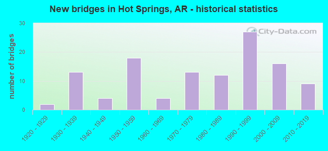
- New bridges - historical statistics
- 21920-1929
- 131930-1939
- 41940-1949
- 181950-1959
- 41960-1969
- 131970-1979
- 121980-1989
- 271990-1999
- 162000-2009
- 92010-2019

- Reconstructed bridges - Historical Statistics
- 21950-1959
- 41960-1969
- 21970-1979
- 11980-1989
- 21990-1999
- 12000-2009


- Bridge Condition - Deck
- 8.3%Very good
- 59.4%Good
- 25.0%Satisfactory
- 7.3%Fair

- Bridge Condition - Superstructure
- 1.0%Excellent
- 26.0%Very good
- 34.4%Good
- 24.0%Satisfactory
- 13.5%Fair
- 1.0%Poor

- Bridge Condition - Substructure
- 2.1%Excellent
- 13.5%Very good
- 34.4%Good
- 31.3%Satisfactory
- 18.8%Fair

- Bridge Condition - Channel
- 1.1%Excellent
- 21.3%Very good
- 26.6%Good
- 39.4%Satisfactory
- 11.7%Fair

- Bridge Condition - Culverts
- 9.1%Very good
- 40.9%Good
- 45.5%Satisfactory
- 4.5%Fair
Find on map >> Show street view
Structure Number: 6372, Location: .25 MI E Lakeshore Dr. (Lat: 34.470400, Lng: -93.089850), Route carried "under" structure: City street 37595, Structure Length: 0. m, Average Daily Traffic: 475 (year 1991), Truck Traffic: 1%, Features Intersected: STOKES CR & McCLOED DR, Facility Carried by Structure: US 270- 5 McCloed
Minimum Vertical Clearance: 4.78m (15.68ft), Kilometerpoint: 0.853, Length of Maximum Span: 0.0m
Find on map >> Show street view
Structure Number: 6425, Location: JCT US 270 BYPS&SH 7 (Lat: 34.464997, Lng: -93.060386), Route carried "under" structure: State highway 7, Structure Length: 0. m, Average Daily Traffic: 22,000 (year 2014), Truck Traffic: 1%, Features Intersected: SH 7
Minimum Vertical Clearance: 5.27m (17.29ft), Kilometerpoint: 12.534, Length of Maximum Span: 0.0m
Find on map >> Show street view
Structure Number: 6947, Location: 2.61 M N US 270 (Lat: 34.502528, Lng: -92.974711), Route carried "under" structure: County highway 88, Structure Length: 0. m, Average Daily Traffic: 1,324 (year 1994), Truck Traffic: 1%, Features Intersected: Spring St., Facility Carried by Structure: US 70 Log 2.61
Minimum Vertical Clearance: 5.33m (17.49ft), Kilometerpoint: 16.705, Length of Maximum Span: 0.0m
Find on map >> Show street view
Structure Number: 6948, Location: US 70 Bypass @ Spring St. (Lat: 34.502669, Lng: -92.975861), Route carried "under" structure: Ramp US 70, Structure Length: 0. m, Average Daily Traffic: 6,500 (year 2014), Truck Traffic: 1%, Features Intersected: US 70 & US 70B, Spring S
Minimum Vertical Clearance: 6.27m (20.57ft), Kilometerpoint: 4.200, Length of Maximum Span: 0.0m
Find on map >> Show street view
Structure Number: 6948, Location: US 70 Bypass @ Spring St. (Lat: 34.502669, Lng: -92.975861), Route carried "under" structure: Ramp US 70, Structure Length: 0. m, Average Daily Traffic: 6,500 (year 2014), Truck Traffic: 1%, Features Intersected: US 70 & US 70B, Spring S
Minimum Vertical Clearance: 5.05m (16.57ft), Kilometerpoint: 4.200, Length of Maximum Span: 0.0m
Find on map >> Show street view
Structure Number: 6948, Location: US 70 Bypass @ Spring St. (Lat: 34.502669, Lng: -92.975861), Route carried "under" structure: County highway 88, Structure Length: 0. m, Average Daily Traffic: 100 (year 2004), Features Intersected: US 70 & US 70B, Spring S, Facility Carried by Structure: US 70 Flyover
Minimum Vertical Clearance: 8.56m (28.08ft), Kilometerpoint: 16.818, Length of Maximum Span: 0.0m
Find on map >> Show street view
Structure Number: 6948, Location: US 70 Bypass @ Spring St. (Lat: 34.502669, Lng: -92.975861), Route carried "under" structure: Business US 70, Structure Length: 0. m, Average Daily Traffic: 3,150 (year 2008), Truck Traffic: 1%, Features Intersected: US 70 & US 70B, Spring S
Minimum Vertical Clearance: 14.38m (47.18ft), Kilometerpoint: 8.916, Length of Maximum Span: 0.0m
Find on map >> Show street view
Structure Number: 6948, Location: US 70 Bypass @ Spring St. (Lat: 34.502669, Lng: -92.975861), Route carried "under" structure: Business US 70, Structure Length: 0. m, Average Daily Traffic: 3,150 (year 2008), Truck Traffic: 1%, Features Intersected: US 70 & US 70B, Spring S
Minimum Vertical Clearance: 13.50m (44.29ft), Kilometerpoint: 8.916, Length of Maximum Span: 0.0m
Find on map >> Show street view
Structure Number: 6949, Location: US 70 WB Ramp & Spring St (Lat: 34.502956, Lng: -92.976189), Route carried "under" structure: County highway 88, Structure Length: 0. m, Average Daily Traffic: 100 (year 2004), Truck Traffic: 1%, Features Intersected: Spring St., Facility Carried by Structure: US 70B Log 5.54
Minimum Vertical Clearance: 8.26m (27.10ft), Kilometerpoint: 16.850, Length of Maximum Span: 0.0m
Find on map >> Show street view
Structure Number: 6974, Location: 1 Mi E Hot Spring City Li (Lat: 34.504631, Lng: -92.984769), Route carried "under" structure: Business US 70, Structure Length: 0. m, Average Daily Traffic: 3,350 (year 2014), Truck Traffic: 12%, Features Intersected: US 70B Log 5.02, Facility Carried by Structure: Westinghouse Drive
Minimum Vertical Clearance: 5.02m (16.47ft), Kilometerpoint: 8.079, Length of Maximum Span: 0.0m
Find on map >> Show street view
Structure Number: 6974, Location: 1 Mi E Hot Spring City Li (Lat: 34.504631, Lng: -92.984769), Route carried "under" structure: Business US 70, Structure Length: 0. m, Average Daily Traffic: 3,350 (year 2014), Truck Traffic: 12%, Features Intersected: US 70B Log 5.02, Facility Carried by Structure: Westinghouse Drive
Minimum Vertical Clearance: 5.12m (16.80ft), Kilometerpoint: 8.079, Length of Maximum Span: 0.0m
Find on map >> Show street view
Structure Number: 7206, Location: 2.61M N US 270 (Lat: 34.502589, Lng: -92.975050), Route carried "under" structure: County highway 88, Structure Length: 0. m, Average Daily Traffic: 1,324 (year 1994), Truck Traffic: 1%, Features Intersected: Spring Street, Facility Carried by Structure: US 70 - 9 Log 2.61
Minimum Vertical Clearance: 5.05m (16.57ft), Kilometerpoint: 16.753, Length of Maximum Span: 0.0m
Find on map >> Show street view
Structure Number: 7207, Location: 2.80 M N US 270 (Lat: 34.504511, Lng: -92.974869), Route carried "under" structure: Business US 70, Structure Length: 0. m, Average Daily Traffic: 2,900 (year 2011), Truck Traffic: 1%, Features Intersected: US 70B
Minimum Vertical Clearance: 7.19m (23.59ft), Kilometerpoint: 8.980, Length of Maximum Span: 0.0m
Find on map >> Show street view
Structure Number: 7207, Location: 2.80 M N US 270 (Lat: 34.504511, Lng: -92.974869), Route carried "under" structure: Business US 70, Structure Length: 0. m, Features Intersected: US 70B
Minimum Vertical Clearance: 6.52m (21.39ft), Kilometerpoint: 8.980, Length of Maximum Span: 0.0m
Structure Number: 7207, Location: 2.80 M N US 270 (Lat: 34.504511, Lng: -92.974869), Route carried "under" structure: Business US 70, Structure Length: 0. m, Features Intersected: US 70B
Minimum Vertical Clearance: 6.52m (21.39ft), Kilometerpoint: 8.980, Length of Maximum Span: 0.0m
Find on map >> Show street view
Structure Number: 7207, Location: 2.80 M N US 270 (Lat: 34.504511, Lng: -92.974869), Route carried "under" structure: Business US 70, Structure Length: 0. m, Average Daily Traffic: 2,900 (year 2011), Truck Traffic: 1%, Features Intersected: US 70B
Minimum Vertical Clearance: 6.70m (21.98ft), Kilometerpoint: 8.980, Length of Maximum Span: 0.0m
Find on map >> Show street view
Structure Number: 19154, Location: 0.23MI S BELDING ST (Lat: 34.492692, Lng: -93.048356), Route carried "under" structure: City street 54320, Structure Length: 0. m, Average Daily Traffic: 1,959 (year 1983), Truck Traffic: 1%, Features Intersected: SHADY GROVE, Facility Carried by Structure: AR MIDLAND RR
Minimum Vertical Clearance: 3.50m (11.48ft), Kilometerpoint: 0.370, Length of Maximum Span: 0.0m
Find on map >> Show street view
Structure Number: 19154, Location: 0.23MI S BELDING ST (Lat: 34.492692, Lng: -93.048356), Route carried "under" structure: City street 54320, Structure Length: 0. m, Truck Traffic: 1%, Features Intersected: SHADY GROVE, Facility Carried by Structure: AR MIDLAND RR
Minimum Vertical Clearance: 3.52m (11.55ft), Kilometerpoint: 0.370, Length of Maximum Span: 0.0m
Find on map >> Show street view
Structure Number: A2943, Location: 3.54 MI E SH7 (Lat: 34.508419, Lng: -93.009700), Route carried "under" structure: City street 38640, Structure Length: 0. m, Average Daily Traffic: 146 (year 1998), Truck Traffic: 1%, Features Intersected: Br. GulphaCrk, McClendon, Facility Carried by Structure: US 70B EB Log 3.5
Minimum Vertical Clearance: 5.10m (16.73ft), Kilometerpoint: 0.048, Length of Maximum Span: 0.0m
Find on map >> Show street view
Structure Number: A3081, Location: 1.89 MI E SH 7 HOT SPRING (Lat: 34.518931, Lng: -93.033500), Route carried "under" structure: Spur State highway 7, Structure Length: 0. m, Average Daily Traffic: 6,600 (year 2014), Truck Traffic: 1%, Features Intersected: SH 7 Spur
Minimum Vertical Clearance: 4.51m (14.80ft), Kilometerpoint: 0.048, Length of Maximum Span: 0.0m
Find on map >> Show street view
Structure Number: A6376, Location: 1.7 MI W OF SH 7 (Lat: 34.468439, Lng: -93.088111), Route carried "under" structure: City street 31890, Structure Length: 0. m, Average Daily Traffic: 3,322 (year 1991), Truck Traffic: 1%, Features Intersected: LAKESHORE DRIVE, Facility Carried by Structure: 270-5 WB Lakeshore
Minimum Vertical Clearance: 5.54m (18.18ft), Kilometerpoint: 9.334, Length of Maximum Span: 0.0m
Find on map >> Show street view
Structure Number: A6427, Location: 1.9 MI E SH 7 (Lat: 34.464100, Lng: -93.027631), Route carried "under" structure: City street 52430, Structure Length: 0. m, Average Daily Traffic: 25 (year 1991), Truck Traffic: 1%, Features Intersected: SHADY GROVE RD, Facility Carried by Structure: US 270,WB Log 1.88
Minimum Vertical Clearance: 5.05m (16.57ft), Kilometerpoint: 4.490, Length of Maximum Span: 0.0m
Find on map >> Show street view
Structure Number: A6493, Location: 2.3 MI E SH 7 (Lat: 34.465689, Lng: -93.021250), Route carried "under" structure: State highway 128, Structure Length: 0. m, Average Daily Traffic: 13,000 (year 2014), Truck Traffic: 1%, Features Intersected: SH 128, Facility Carried by Structure: US 270, WB LNS
Minimum Vertical Clearance: 6.68m (21.92ft), Kilometerpoint: 5.520, Length of Maximum Span: 0.0m
Find on map >> Show street view
Structure Number: A6806, Location: 3.1 mi. E SH 7 (Lat: 34.470839, Lng: -92.989639), Route carried "under" structure: Business US 270, Structure Length: 0. m, Average Daily Traffic: 11,000 (year 2014), Truck Traffic: 1%, Features Intersected: US 270B, Facility Carried by Structure: US 70 WB
Minimum Vertical Clearance: 5.39m (17.68ft), Kilometerpoint: 7.371, Length of Maximum Span: 0.0m
Find on map >> Show street view
Structure Number: A6807, Location: 3.3 Mi. E Sh 7 (Lat: 34.474178, Lng: -92.987503), Route carried "under" structure: City street 61683, Structure Length: 0. m, Average Daily Traffic: 100 (year 2000), Truck Traffic: 1%, Features Intersected: Gulpha Cr.,Westinghouse, Facility Carried by Structure: US 70 WB log 0.47
Minimum Vertical Clearance: 4.85m (15.91ft), Kilometerpoint: 0.483, Length of Maximum Span: 0.0m
Find on map >> Show street view
Structure Number: A6809, Location: 4.1 Mi. E SH 7 (Lat: 34.484850, Lng: -92.981481), Route carried "under" structure: County highway 91, Structure Length: 0. m, Average Daily Traffic: 100 (year 2000), Truck Traffic: 1%, Features Intersected: Bald Mt. Rd. & Gulpha Cr, Facility Carried by Structure: US 70 WB log 1.30
Minimum Vertical Clearance: 5.02m (16.47ft), Kilometerpoint: 0.483, Length of Maximum Span: 0.0m
Find on map >> Show street view
Structure Number: B6376, Location: 1.7 MI WEST SH 7 (Lat: 34.468411, Lng: -93.088253), Route carried "under" structure: City street 31890, Structure Length: 0. m, Average Daily Traffic: 3,322 (year 1991), Truck Traffic: 1%, Features Intersected: Lakeshore Dr., Facility Carried by Structure: 270-5 EB Lakeshore
Minimum Vertical Clearance: 5.63m (18.47ft), Kilometerpoint: 9.333, Length of Maximum Span: 0.0m
Find on map >> Show street view
Structure Number: B6427, Location: 1.9 MI E SH7(Bypass) (Lat: 34.464011, Lng: -93.027558), Route carried "under" structure: City street 52430, Structure Length: 0. m, Average Daily Traffic: 25 (year 1991), Truck Traffic: 1%, Features Intersected: SHADY GROVE RD, Facility Carried by Structure: US 270,EB Log 1.88
Minimum Vertical Clearance: 5.10m (16.73ft), Kilometerpoint: 4.506, Length of Maximum Span: 0.0m
Find on map >> Show street view
Structure Number: B6493, Location: 2.3 MI E SH 7 (Lat: 34.465589, Lng: -93.021250), Route carried "under" structure: State highway 128, Structure Length: 0. m, Average Daily Traffic: 13,000 (year 2014), Truck Traffic: 1%, Features Intersected: SH 128, Facility Carried by Structure: US 270, EB LNS
Minimum Vertical Clearance: 5.15m (16.90ft), Kilometerpoint: 5.504, Length of Maximum Span: 0.0m
Find on map >> Show street view
Structure Number: B6806, Location: 3.1 mi. E Sh 7 (Lat: 34.470822, Lng: -92.989533), Route carried "under" structure: Business US 270, Structure Length: 0. m, Average Daily Traffic: 11,000 (year 2014), Truck Traffic: 1%, Features Intersected: US 270B, Facility Carried by Structure: US 70 EB
Minimum Vertical Clearance: 5.33m (17.49ft), Kilometerpoint: 7.403, Length of Maximum Span: 0.0m
Find on map >> Show street view
Structure Number: B6807, Location: 3.3 Mi. E SH 7 (Lat: 34.474042, Lng: -92.987428), Route carried "under" structure: City street 61683, Structure Length: 0. m, Average Daily Traffic: 100 (year 2000), Truck Traffic: 1%, Features Intersected: Gulpha Cr.,Westinghouse, Facility Carried by Structure: US 70 EB log 0.47
Minimum Vertical Clearance: 5.76m (18.90ft), Kilometerpoint: 0.483, Length of Maximum Span: 0.0m
Find on map >> Show street view
Structure Number: B6809, Location: 4.1 Mi. E SH 7 (Lat: 34.484822, Lng: -92.981378), Route carried "under" structure: County highway 91, Structure Length: 0. m, Average Daily Traffic: 100 (year 2000), Truck Traffic: 1%, Features Intersected: Bald Mt. Rd & Gulpha Cr, Facility Carried by Structure: US 70 EB log 1.3
Minimum Vertical Clearance: 5.76m (18.90ft), Kilometerpoint: 0.483, Length of Maximum Span: 0.0m
Find on map >> Show street view
Structure Number: C6376, Location: 1.7 MI WEST SH 7 (Lat: 34.468500, Lng: -93.087869), Route carried "under" structure: City street 31890, Structure Length: 0. m, Average Daily Traffic: 590 (year 1991), Truck Traffic: 1%, Features Intersected: LAKESHORE DRIVE, Facility Carried by Structure: 270-5 Aviation Rmp
Minimum Vertical Clearance: 5.15m (16.90ft), Kilometerpoint: 9.334, Length of Maximum Span: 0.0m