Bridge Statistics for Opelousas, Louisiana (LA)
Condition, Traffic, Stress, Structural Evaluation, Project Costs
- National Bridge Inventory (NBI) Statistics
- 100Number of bridges
- 1,198ft / 365mTotal length
- $4,782,000Total costs
- 715,036Total average daily traffic
- 112,559Total average daily truck traffic
- National Bridge Inventory (NBI) Registered Bridges for Opelousas
- No street view available for this location
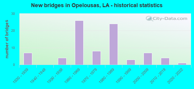
- New bridges - historical statistics
- 71930-1939
- 41950-1959
- 261960-1969
- 81970-1979
- 241980-1989
- 31990-1999
- 72000-2009
- 42010-2019
- 12020-2022


- Bridge Condition - Deck
- 6.1%Very good
- 40.8%Good
- 34.7%Satisfactory
- 16.3%Fair
- 2.0%Serious

- Bridge Condition - Superstructure
- 8.2%Very good
- 42.9%Good
- 32.7%Satisfactory
- 14.3%Fair
- 2.0%Poor

- Bridge Condition - Substructure
- 6.1%Very good
- 46.9%Good
- 28.6%Satisfactory
- 8.2%Fair
- 8.2%Poor
- 2.0%Imminent failure

- Bridge Condition - Channel
- 1.4%Excellent
- 37.5%Very good
- 45.8%Good
- 13.9%Satisfactory
- 1.4%Fair

- Bridge Condition - Culverts
- 8.6%Very good
- 42.9%Good
- 42.9%Satisfactory
- 5.7%Fair
Find on map >> Show street view
Structure Number: 34930344920311, Location: 0.2 Mi. S. Of I49 Srvc Rd (Lat: 30.575019, Lng: -92.053581), Route carried "on" structure: County highway , Year Built: 1971, Status: Posted for load, Structure Length: 2.32m (7.61ft), Average Daily Traffic: 575 (year 2020), Average Future Daily Traffic: 632 (year 2040), Design Load: HS 20, Features Intersected: Bayou Kennison, Facility Carried by Structure: Kennerson Rd
Minimum Vertical Clearance: 30+ m (98+ ft), Kilometerpoint: 0.000, Lanes on structure: 2, Owner: County Highway Agency, Approaching Roadway Width: 12.2m (40.0ft), Material/Design: Concrete, Design/Construction: Slab, Number Of Spans In Main Unit: 4, Length of Maximum Span: 5.8m (19.0ft), Curb-To-Curb Width: 8.5m (27.9ft), Out-to-Out Width: 9.4m (30.8ft)
Condition: Deck: Fair, Superstructure: Fair, Substructure: Poor, Channel: Good, Operating Rating: 18.5 metric tons, Method Used To Determine Operating Rating: Load and Resistance Factor Rating (LRFR) rating reported by rating factor(RF) method using HL-93 loadings, Inventory Rating: 14.3 metric tons, Method Used To Determine Inventory Rating: Load and Resistance Factor Rating (LRFR) rating reported by rating factor(RF) method using HL-93 loadings, Structural Evaluation: Meets minimum limits, Deck Geometry: Somewhat better than minimum adequacy, Waterway Adequacy: Better than present minimum criteria, Approach Roadway Alignment: Equal to present minimum criteria, Bridge Posting: Required (Relationship of Operating Rating to Maximum Legal Load: 30.0 - 39.9% below), Designated Inspection Frequency: Every 24 months, Other Special Inspection Frequency: Every 12 months, Inspection Date: January 2021, Other Special Inspection Date: January 2022, Deck Structure Type: Concrete Precast Panels, Wearing Surface/Protective System: Wearing Surface: Bituminous
Find on map >> Show street view
Structure Number: 34930361920851, Location: 1.5 Mi. SW of US 167 (Lat: 30.598669, Lng: -92.144061), Route carried "on" structure: County highway , Year Built: 1994, Status: Open, Structure Length: 0.94m (3.08ft), Average Daily Traffic: 125 (year 2020), Average Future Daily Traffic: 137 (year 2040), Design Load: HS 20, Features Intersected: Drainage Canal, Facility Carried by Structure: Thomas Ave
Minimum Vertical Clearance: 30+ m (98+ ft), Kilometerpoint: 0.000, Lanes on structure: 2, Base Highway Network: Yes, Owner: County Highway Agency, Approaching Roadway Width: 6.1m (20.0ft), Skew: 1 degrees, Material/Design: Steel, Design/Construction: Culvert, Number Of Spans In Main Unit: 3, Length of Maximum Span: 2.1m (6.9ft)
Condition: Channel: Very good, Culverts: Good, Operating Rating: 97.2 metric tons, Method Used To Determine Operating Rating: Load and Resistance Factor Rating (LRFR) rating reported by rating factor(RF) method using HL-93 loadings, Inventory Rating: 74.5 metric tons, Method Used To Determine Inventory Rating: Load and Resistance Factor Rating (LRFR) rating reported by rating factor(RF) method using HL-93 loadings, Structural Evaluation: Better than present minimum criteria, Waterway Adequacy: Equal to present desirable criteria, Approach Roadway Alignment: Equal to present minimum criteria, Designated Inspection Frequency: Every 24 months, Inspection Date: January 2021
Find on map >> Show street view
Structure Number: 34900121301431, Location: 0.5 MI E OF I-49 (Lat: 30.535781, Lng: -92.058461), Route carried "under" structure: Ramp US 190, Structure Length: 0. m, Average Daily Traffic: 1,900 (year 2016), Features Intersected: US 190 FRONTAGE RD. UNDE
Minimum Vertical Clearance: 4.27m (14.01ft), Kilometerpoint: 0.026, Lanes on structure: 2, Lanes under structure: 2, Length of Maximum Span: 0.0m
Find on map >> Show street view
Structure Number: 34900121301431, Location: 0.5 MI E OF I-49 (Lat: 30.535781, Lng: -92.058461), Route carried "under" structure: Ramp US 190, Structure Length: 0. m, Average Daily Traffic: 1,900 (year 2016), Features Intersected: US 190 FRONTAGE RD UNDER
Minimum Vertical Clearance: 4.30m (14.11ft), Kilometerpoint: 1.854, Lanes on structure: 2, Lanes under structure: 2, Length of Maximum Span: 0.0m
Find on map >> Show street view
Structure Number: 34900121301432, Location: 0.5 MI E OF I-49 (Lat: 30.535950, Lng: -92.058689), Route carried "under" structure: Ramp US 190, Structure Length: 0. m, Average Daily Traffic: 1,900 (year 2016), Features Intersected: US 190 FRONTAGE RD UNDER
Minimum Vertical Clearance: 4.18m (13.71ft), Kilometerpoint: 0.003, Lanes on structure: 2, Lanes under structure: 2, Length of Maximum Span: 0.0m
Find on map >> Show street view
Structure Number: 34900121301432, Location: 0.5 MI E OF I-49 (Lat: 30.535950, Lng: -92.058689), Route carried "under" structure: Ramp US 190, Structure Length: 0. m, Average Daily Traffic: 1,900 (year 2016), Features Intersected: US 190 FRONTAGE RD UNDER
Minimum Vertical Clearance: 4.24m (13.91ft), Kilometerpoint: 0.257, Lanes on structure: 2, Lanes under structure: 2, Length of Maximum Span: 0.0m
Find on map >> Show street view
Structure Number: 34904550207221, Location: 1.1 MI E OF LA 182 (Lat: 30.478050, Lng: -92.076561), Route carried "under" structure: State highway 3233, Structure Length: 0. m, Average Daily Traffic: 4,600 (year 2014), Features Intersected: LA 3233 E UNDER I-49 N
Minimum Vertical Clearance: 4.85m (15.91ft), Kilometerpoint: 1.773, Lanes on structure: 2, Lanes under structure: 2, Length of Maximum Span: 0.0m
Find on map >> Show street view
Structure Number: 34904550207221, Location: 1.1 MI E OF LA 182 (Lat: 30.478269, Lng: -90.076361), Route carried "under" structure: State highway 3233, Structure Length: 0. m, Average Daily Traffic: 4,600 (year 2014), Features Intersected: LA 3233 W UNDER I-49 N
Minimum Vertical Clearance: 5.15m (16.90ft), Kilometerpoint: 0.232, Lanes on structure: 2, Lanes under structure: 2, Length of Maximum Span: 0.0m
Find on map >> Show street view
Structure Number: 34904550207222, Location: 1.1 MI E OF LA 182 (Lat: 30.478211, Lng: -92.076669), Route carried "under" structure: State highway 3233, Structure Length: 0. m, Average Daily Traffic: 4,600 (year 2014), Features Intersected: LA 3233 W UNDER I-49 S
Minimum Vertical Clearance: 5.21m (17.09ft), Kilometerpoint: 0.262, Lanes on structure: 2, Lanes under structure: 2, Length of Maximum Span: 0.0m
Find on map >> Show street view
Structure Number: 34904550207222, Location: 1.1 MI E OF LA 182 (Lat: 30.477981, Lng: -92.076869), Route carried "under" structure: State highway 3233, Structure Length: 0. m, Average Daily Traffic: 4,600 (year 2014), Features Intersected: LA 3233 E UNDER I-49 S
Minimum Vertical Clearance: 4.79m (15.72ft), Kilometerpoint: 1.745, Lanes on structure: 2, Lanes under structure: 2, Length of Maximum Span: 0.0m
Find on map >> Show street view
Structure Number: 34904550210041, Location: 0.8 MI E OF LA 182 (Lat: 30.518531, Lng: -92.068411), Route carried "under" structure: State highway 31, Structure Length: 0. m, Average Daily Traffic: 17,200 (year 2015), Features Intersected: LA 31 EB UNDER I-49 NB
Minimum Vertical Clearance: 4.97m (16.31ft), Kilometerpoint: 1.337, Lanes on structure: 2, Length of Maximum Span: 0.0m
Find on map >> Show street view
Structure Number: 34904550210041, Location: 0.8 MI E OF LA 182 (Lat: 30.518669, Lng: -92.068239), Route carried "under" structure: State highway 31, Structure Length: 0. m, Average Daily Traffic: 17,200 (year 2015), Features Intersected: LA 31 WB UNDER I-49 NB
Minimum Vertical Clearance: 5.00m (16.40ft), Kilometerpoint: 13.546, Lanes on structure: 2, Length of Maximum Span: 0.0m
Find on map >> Show street view
Structure Number: 34904550210042, Location: 0.8 MI E OF LA 182 (Lat: 30.518561, Lng: -92.068700), Route carried "under" structure: State highway 31, Structure Length: 0. m, Average Daily Traffic: 17,200 (year 2015), Features Intersected: LA 31 EB UNDER I-49 SB
Minimum Vertical Clearance: 4.82m (15.81ft), Kilometerpoint: 1.308, Lanes on structure: 2, Length of Maximum Span: 0.0m
Find on map >> Show street view
Structure Number: 34904550210042, Location: 0.8 MI E OF LA 182 (Lat: 30.518711, Lng: -92.068531), Route carried "under" structure: State highway 31, Structure Length: 0. m, Average Daily Traffic: 17,200 (year 2015), Features Intersected: LA 31 WB UNDER I-49 SB
Minimum Vertical Clearance: 4.79m (15.72ft), Kilometerpoint: 13.573, Lanes on structure: 2, Length of Maximum Span: 0.0m
Find on map >> Show street view
Structure Number: 34904550210951, Location: US 190 UNDER I-49 (Lat: 30.531989, Lng: -92.065219), Route carried "under" structure: US 190, Structure Length: 0. m, Average Daily Traffic: 23,800 (year 2014), Features Intersected: US 190 WB UNDER I-49 NB
Minimum Vertical Clearance: 5.82m (19.09ft), Kilometerpoint: 24.608, Lanes on structure: 2, Length of Maximum Span: 0.0m
Find on map >> Show street view
Structure Number: 34904550210951, Location: US 190 UNDER I-49 (Lat: 30.531700, Lng: -92.065439), Route carried "under" structure: US 190, Structure Length: 0. m, Average Daily Traffic: 23,800 (year 2014), Features Intersected: US 190 EB UNDER I-49 NB
Minimum Vertical Clearance: 5.49m (18.01ft), Kilometerpoint: 1.540, Lanes on structure: 2, Length of Maximum Span: 0.0m
Find on map >> Show street view
Structure Number: 34904550210952, Location: US 190 UNDER I-49 (Lat: 30.531581, Lng: -92.065800), Route carried "under" structure: US 190, Structure Length: 0. m, Average Daily Traffic: 23,800 (year 2014), Features Intersected: US 190 EB UNDER I-49 SB
Minimum Vertical Clearance: 5.15m (16.90ft), Kilometerpoint: 1.503, Lanes on structure: 2, Length of Maximum Span: 0.0m
Find on map >> Show street view
Structure Number: 34904550210952, Location: US 190 UNDER I-49 (Lat: 30.531881, Lng: -92.065561), Route carried "under" structure: US 190, Structure Length: 0. m, Average Daily Traffic: 23,800 (year 2014), Features Intersected: US 190 WB UNDER I-49 SB
Minimum Vertical Clearance: 5.64m (18.50ft), Kilometerpoint: 24.644, Lanes on structure: 2, Length of Maximum Span: 0.0m